EP2287566A1 - Procédé de transmission d'informations de position sur une carte et son appareil - Google Patents
Procédé de transmission d'informations de position sur une carte et son appareil Download PDFInfo
- Publication number
- EP2287566A1 EP2287566A1 EP10181076A EP10181076A EP2287566A1 EP 2287566 A1 EP2287566 A1 EP 2287566A1 EP 10181076 A EP10181076 A EP 10181076A EP 10181076 A EP10181076 A EP 10181076A EP 2287566 A1 EP2287566 A1 EP 2287566A1
- Authority
- EP
- European Patent Office
- Prior art keywords
- data
- node
- information
- road
- position information
- Prior art date
- Legal status (The legal status is an assumption and is not a legal conclusion. Google has not performed a legal analysis and makes no representation as to the accuracy of the status listed.)
- Granted
Links
Images


Classifications
-
- G—PHYSICS
- G08—SIGNALLING
- G08G—TRAFFIC CONTROL SYSTEMS
- G08G1/00—Traffic control systems for road vehicles
- G08G1/01—Detecting movement of traffic to be counted or controlled
-
- G—PHYSICS
- G09—EDUCATION; CRYPTOGRAPHY; DISPLAY; ADVERTISING; SEALS
- G09B—EDUCATIONAL OR DEMONSTRATION APPLIANCES; APPLIANCES FOR TEACHING, OR COMMUNICATING WITH, THE BLIND, DEAF OR MUTE; MODELS; PLANETARIA; GLOBES; MAPS; DIAGRAMS
- G09B29/00—Maps; Plans; Charts; Diagrams, e.g. route diagram
- G09B29/10—Map spot or coordinate position indicators; Map reading aids
-
- G—PHYSICS
- G01—MEASURING; TESTING
- G01C—MEASURING DISTANCES, LEVELS OR BEARINGS; SURVEYING; NAVIGATION; GYROSCOPIC INSTRUMENTS; PHOTOGRAMMETRY OR VIDEOGRAMMETRY
- G01C21/00—Navigation; Navigational instruments not provided for in groups G01C1/00 - G01C19/00
- G01C21/26—Navigation; Navigational instruments not provided for in groups G01C1/00 - G01C19/00 specially adapted for navigation in a road network
- G01C21/28—Navigation; Navigational instruments not provided for in groups G01C1/00 - G01C19/00 specially adapted for navigation in a road network with correlation of data from several navigational instruments
- G01C21/30—Map- or contour-matching
-
- G—PHYSICS
- G08—SIGNALLING
- G08G—TRAFFIC CONTROL SYSTEMS
- G08G1/00—Traffic control systems for road vehicles
- G08G1/09—Arrangements for giving variable traffic instructions
- G08G1/0962—Arrangements for giving variable traffic instructions having an indicator mounted inside the vehicle, e.g. giving voice messages
- G08G1/0968—Systems involving transmission of navigation instructions to the vehicle
- G08G1/0969—Systems involving transmission of navigation instructions to the vehicle having a display in the form of a map
Definitions
- the present invention relates to a method of transmitting position information of a digital map and an apparatus utilized for the method, particularly, enabling to transmit a position on a digital map efficiently and precisely.
- the navigation vehicle-mounted apparatus holds a data base of a digital map and displays traffic jam or position of traffic accident on a map based on traffic jam information or traffic accident information provided from a traffic information center or the like, further, executes search for route by adding these information to conditions therefor.
- the database of the digital map is formed by several companies in Japan, due to a difference in basic drawings and digitizing technology, the map data includes error and the error differs by the digital maps of the respective companies.
- a node number is defined at a node such as a crossroads present in a road network
- a link number is defined for a link representing a road between nodes, according to the digital map data base of the respective companies, respective crossroads and roads are stored in correspondence with node numbers and link numbers, further, in traffic information, a road is specified by a link number and a spot on the road is displayed by an expression method stating some meters from a head thereof.
- a node number or a link number defined in a road network needs to switch to a new number in accordance with newly laying or changing roads, further, when a node number or a link number is changed, the digital map data of the respective companies must be updated. Therefore, according to a system of transmitting position information of a digital map by using a node number or a link number, enormous social cost is required for maintenance thereof.
- a system of also transmitting "additional information" such as kind of road, road number, a number of crossing links of nodes, angles of crossing links, name of crossroads and so on in a road section such that map matching on the receiving side can accurately be executed even when a transmission data amount of the "road shape data” is reduced further, proposed a system of thinning the transmission data amount of the "road shape data” within a range by which erroneous matching on the receiving side is not brought about.
- the map matching on the receiving side is carried out, for example, as follows.
- Fig. 45 when as "road shape data" representing a road shape of a road bringing about traffic jam in section A through B, longitude and latitude data of spots P 0 (x 0 , y 0 ), P 1 (x 1 , y 1 ), ⁇ ⁇ , P k (x k , y k ) are transmitted as follows, x 0 ⁇ y 0 ⁇ x 1 ⁇ y 1 ⁇ ⁇ x k ⁇ y k , as shown by Fig.
- the receiving side selects roads included in a range of error centering on spot P 0 (x 0 , y 0 ) by using map data read from a digital map data base of its own as candidates and narrows down candidates therefrom by using transmitted "additional information".
- map data read from a digital map data base of its own as candidates
- narrows down candidates therefrom by using transmitted "additional information”.
- positions most proximate to (x 0 , y 0 ) and (x k , y k ) of the road are calculated and the section is defined as a road section represented by "road shape data".
- positions Q 0 and Ro on the respective candidate roads most proximate to P 0 (x 0 , y 0 ) are calculated and distances between P 0 through Q 0 and P 0 through R 0 are calculated.
- the operation is executed for respective points P 1 (x 1 , y 1 ) ⁇ , P k (x k , y k ).
- a road section minimizing a value produced by adding square means of the distances from respective points P 0 , P 1 , ⁇ , P k is calculated and the road section is specified by a method of determining the road section as a road section represented by the "road shape data".
- the traffic jam section of A through B is specified based on the transmitted "relative position data" with a position of starting the road section calculated from the "road shape data” as onset.
- the invention responds to such problems and it is an object thereof to provide a method of transmitting position information of a digital map for further improving a method of transmitting position information of a digital map by using "shape data" specifying a map shape on the digital map and "relative position data” specifying a relative position in the map shape specified by the "shape data", capable of transmitting a position on the digital map efficiently and accurately, further, capable of transmitting also position information other than a road shape of a spot on a road, further, provide an apparatus used therefor.
- a method of transmitting position information in which transmitting side transmits position information including coordinate series information for specifying a vector shape on a digital map and a receiving side executes map matching by the coordinate series information to thereby identify the vector shape on the digital map wherein the coordinate series information is transmitted by adding intercept azimuth information of a coordinate point included in the coordinate series information thereto.
- the coordinate series information is transmitted by adding information of a height of a coordinate point included in the coordinate series information thereto.
- the coordinate series information includes position information of a coordinate point and information of a function approximating the vector information passing through the coordinate point.
- the coordinate series information is constituted by information designating coordinate series information of a reference and information prescribing a distance and a direction of offset with regard to the coordinate series information of the reference.
- a coordinate value of a digital map representing the vector shape is included in the coordinate series information by making the coordinate value transit in a range by which erroneous matching is not produced.
- relative distance information from a reference point set at a middle of the vector shape is included in the position information.
- event information made to directly correspond to a coordinate point of the coordinate series information is included in the position information.
- a direction identifying flag is included in the position information and a vehicle advancing direction influenced by an event produced at a road is clearly indicated by the direction identifying flag.
- a direction identifying flag is included in the coordinate series information and a situation of one way traffic regulation of a road specified by the coordinate series information is clearly indicated by the direction identifying flag.
- a plurality of reference points are set in the road shape and information of travel time between the reference points is included in the position information.
- a vector shape of other than a road is specified by the coordinate series information.
- the transmitting side transmits the position information by including coordinate series information and reference point relative position information for specifying one or more of reference points and relative position information of a target position with respect to the reference points thereto and the receiving side identifies the vector shape on the digital map by executing the match mapping by the coordinate series information, specifies positions of the reference points in the vector shape by using the reference point relative position information and specifies the target position by using the relative position information of the target position with respect to the reference points.
- the receiving side restores coordinate series information of coordinate points at equal intervals from the coordinate series information and executes map matching by using the restored coordinate series information.
- an apparatus of restoring a coordinate series for restoring coordinate series information of coordinate points at equal intervals from coordinate series information subjected to data compression for specifying a vector shape on a digital map there is constituted an apparatus of restoring a coordinate series for restoring coordinate series information of coordinate points at equal intervals from coordinate series information subjected to data compression for specifying a vector shape on a digital map.
- the position on the digital map can efficiently and accurately be transmitted.
- a vehicle advancing direction influenced by an event can be specified.
- data can be transmitted by modifying the data in the form of transmitting travel time or not infringing copyright of map data.
- the invention is applicable also to transmission of vector data of other than a road, further, a position outside of a road on the digital map can also be transmitted.
- the method and the apparatus for restoring data at equal intervals from a compressed shape data series can promote a matching efficiency on the receiving side.
- the numerals in the drawings are 10, 20 position information transmitting/receiving apparatus, 11, 22 position information receiving portion,12 node series restoring portion, 13 map matching portion, 14 digital map data base, 15 digital map displaying portion, 16 event information inputting portion, 17 position information converting portion, and 18, 21 position information transmitting portion.
- FIG. 1 An explanation will be given of an example of a case of transmitting longitude data and latitude data of respective spots indicated by black circles as shape data in order to transmit a road shape from P 1 to P N of a road 2 shown in Fig. 1 .
- the black circles represent nodes and interpolation points of nodes on the roads included in a digital map database.
- a node is set in correspondence with a crossroads, an inlet or an outlet of a tunnel, an inlet or an outlet of a bridge, a boundary of administrative sections or the like and is attached with a node number.
- An interpolation point is a point set for reproducing a road shape between nodes.
- a node and an interpolation point are inclusively referred to as nodes so far as not particularly specified otherwise.
- longitude data and latitude data of respective nodes are stored in digital map databases on a transmitting side and a receiving side, as mentioned above, data respectively include error.
- the transmitting side transmits shape data indicating road shape by including longitude and latitude data of P 1 , P 2 , ⁇ , P N , in order to reduce a data amount, longitude and latitude data of P 1 is displayed by absolute coordinate values (longitude, latitude) and longitude and latitude data of P 2 , ⁇ , P N are displayed by relative coordinate values indicating differences from the longitude and latitude data of P 1 , or differences from longitude and latitude data of a preceding node.
- intercept azimuth information included in the shape data is information of azimuth of an intercept at a position of the respective node, that is, azimuth of a tangential line in contact with a road curve at node p x .
- the intercept azimuth at the node position is displayed in a range of 0 degree through 360 degrees in the clockwise direction by defining an absolute azimuth of due north as 0 degree.
- the intercept azimuth of the node P x can be calculated as follows when a contiguous node disposed on the upstream side of the node p x is defined as p x-1 and a contiguous node disposed on the downstream side of the node p x is defined as p x+1 , by averaging an azimuth ⁇ x-1 of a straight line connecting node p x-1 and node p x and an azimuth ⁇ x of a straight line connecting node p x and p x+1 .
- Fig. 2 shows a procedure of calculating an intercept azimuth of respective node on a transmitting side as follows.
- Intercept azimuths of respective nodes sampled in this way are summarized as node series information representing shape data along with longitude and latitude data of respective nodes as shown by Fig. 3 .
- the node series information is aligned with kinds of vector data represented by node series (in this case, "road"), a total number of nodes (N pieces) and longitude and latitude data and intercept azimuth data with regard to respective nodes starting from node No. P 1 .
- longitude and latitude data and intercept azimuth data of node No. P 1 are displayed by absolute coordinates and an absolute azimuth
- longitude and latitude data and intercept azimuth data of from node No. P 2 through node No. P N are displayed by relative coordinates and relative azimuths in order to reduce a data amount.
- the node series information is converted into a transmission format along with relative position data representing positions of events in the road section represented by the node series information and is transmitted.
- the receiving side receiving the node series information and relative position data executes map matching and specifies the road section represented by the node series information.
- Fig. 5 shows a procedure in map matching.
- step 121 samples a next proximate one as a matching candidate and executes the procedure of step 122.
- spot P x on road 2 is liable to be erroneously matched to road 1 constituting the most proximate road, as shown by Fig. 4 , on the receiving side, in matching, by comparing intercept azimuths of matching candidate point 1 on road 1 most proximate to spot P x and spot P x , matching candidate point 1 can be excluded from the candidate and matching candidate 2 on road 2 next proximate to spot P x can remain as the candidate.
- the method of transmitting position information of the embodiment by including the intercept azimuth information to the position information, matching accuracy on the receiving side is promoted and the candidate can be narrowed down in a short period of time. Therefore, on the receiving side, the transmitted position on the digital map can accurately and swiftly be recognized.
- coordinate points may be resampled at constant intervals on the road shape and the shape data indicating the road shape may include coordinate data of the coordinate points.
- Second Embodiment an explanation will be given of a method of transmitting position information for transmitting shape data by adding data of height.
- Fig. 6 schematically shows vector data series representing a road in the case of representing digital map data in three dimensions of longitude, latitude and height.
- the transmitting side transmits node series information of shape data by including X direction coordinate (longitude), Y direction coordinate (latitude) and Z direction coordinate (altitude) of respective node as shown by Fig. 7 .
- candidate points can be narrowed down by referring to Z direction coordinate of matching candidate points selected based on distances on X-Y plane and transmitted positions on the digital map can accurately and swiftly be recognized.
- Z direction coordinate of respective node is represented by altitude
- the Z direction coordinate may be displayed by a height from the surface of the ground.
- the Z direction coordinate of respective node may be displayed by a slope between the node and a preceding node.
- P 1 through P m2 can be represented by coordinates data of P 1 , P m1 and P m2 , a function approximating an interval of P 1 through P m1 indicated by F (a, b, c) and parameters thereof and a function approximating an interval of P m1 through P m2 indicated by F (d, e, f) and parameters thereof to thereby enable to reduce the data amount.
- Fig. 10 shows node series information in this case.
- a shape represented by F (a, b, c) and F (d, e, f) from coordinates data of P 1 , P m1 and P m2 and parameters thereof and map matching is executed by setting spots at arbitrary intervals on the shape.
- the shape represented by F (a, b, c) and F (d, e, f) may not coincide accurately with the shapes from P 1 through P m1 and P m1 through P m2 of Fig. 9 (a) but may be approximated thereto to a degree of not causing erroneous matching on the receiving side.
- the transmitted data amount can considerably be reduced and efficient formation of data transmission can be achieved.
- an express way or a toll road is expressed by a road separating up and down ways in a number of digital maps and is referred to as double-streaked line.
- road shape data of one road (road 2) utilizes road shape data of other road (road 1) to thereby enable to compress a data amount.
- node spots P 1 ', P 2 ', ⁇ , P n ' of road 2 can be approximated as spots produced by moving road spots P 1 , P 2 , ⁇ , P n in road 1 to a right side (or left side) of road 1 by a constant offset distance (L).
- a direction of offset is a direction orthogonal to a intercept direction of each of the node spots P 1 , P 2 , ⁇ , P n of road 1.
- a shape vector series identifying number constituting an identifying number of shape data at top thereof and a reference vector series number representing shape data to be referred.
- the reference vector series number becomes "none" and there are described longitude and latitude data and intercept azimuth data for respective nodes similar to the first embodiment ( Fig. 3 ).
- node series information of road 2 referring to the shape data of road 1 describes a shape vector series identifying number of road 2, a reference vector series number representing the shape data of road 1 of the reference, an offset distance and an offset direction (right or left of node series constituting master).
- the system of the embodiment is also applicable by constituting an object by roads in a lattice shape in which the number of roads run in parallel.
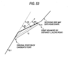
- a producer of the map sets a map shape by achieving original devise and the producer is provided with copyright with regard to the map shape. Therefore, when the map shape is transmitted by shape data as it is, there is a concern of infringing the copyright of the digital map. According to the method of transmitting position information of the embodiment, in order to remove such concern, original map shape is more ore less deformed to a degree of not causing erroneous matching on the receiving side and transmitted.
- Fig. 17 schematically shows deformation of shape data in this case.
- P x an original position provided to map data
- the position is modified to a position of P x '.
- a distance (transition value B) from P x to P x ' is set based on a distance L from spot P x to a contiguous road, further, an azimuth (transition azimuth ⁇ ) P x to P x ' is determined by a random number.
- Fig. 18 shows a procedure of calculating P x '.
- step 272 when B ⁇ ⁇ 2 , the value calculated at step 271 is determined as B.
- notation R designates a random number generating function and is a uniform random number of 0 through 1.
- notation ⁇ represents an absolute azimuth of 0 degree through 360 degrees in the clockwise direction by defining an absolute azimuth of due north by 0 degree.
- the map data can be deformed to a degree of not causing erroneous matching on the receiving side.
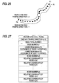
- a node P 4 of a crossroads in the midst of a node series is defined as a reference point and the position of traffic accident is displayed by a relative distance from P 4 .
- traffic jam caused in the road section is displayed by a relative distance from a node P x of a T-road as a reference point.
- Relative position information displayed by using the reference point defined in the road section in this way is transmitted to the receiving side by data shown in Figs. 21(a), 21(b), and 21(c) .
- Fig. 21(a) is node series information specifying the road section.
- Fig. 21(b) is road additional information proposed by Japanese Patent Application No. 242166/1999 displaying a node number linked to the node series information, a number of connection links of crossroads and connection link angles of the respective connection links with respect to crossroads nodes included in the road section for respective crossroads nodes along with a road kind code, a road number and a toll road code of the road constituting an object.
- Fig. 21(c) shows event information for displaying a relative position in the road section and event content of event occurring at the position and the relative position is displayed by a relative distance from a reference point indicated clearly.
- the receiving side can precisely grasp a position at which an event occurs.
- a corresponding event occurring at a corresponding node is described by a corresponding event code and as shown by Fig. 12(b) , event content represented by the respective corresponding event code is described as event details information.
- Fig. 23(a) in the node series information, only a code number and coordinate data are described, and as shown by Fig. 23(b) , as event information, event content and a node number at which event occurs are described.
- the event occurring position can be reproduced with high accuracy.
- Fig. 24 schematically shows a state in which an event A (traffic stop) influencing a vehicle running in a direction of a vehicle advancing direction 1 on a road and an event B (traffic lain regulation) influencing a vehicle running in a direction of a vehicle advancing direction 2, occur.
- event A traffic stop
- event B traffic lain regulation
- position information on the road is transmitted to the receiving side by data shown in Figs. 25(a), 25(b), and 25(c) .
- Fig. 25(a) shows node series information specifying a road section.
- the node series information there is prescribed a definition of direction in which a forward direction with respect to an order of aligning node series is defined as 2 and a rearward direction with respect to the order of aligning the node series is defined as 1.
- Fig. 25(b) is road addition information similar to that in Sixth Embodiment ( Figs. 21(a), 21(b), and 21(c) ).
- Fig. 25(c) shows event information displaying an event content, a relative distance from a reference point as well as a vehicle advancing direction influenced by the event by a direction identifying flag indicating the definition of direction with regard to respective event. That is, a vehicle running in a direction of a vehicle advancing direction 1 is influenced by an event A and therefore, 1 defining a rearward direction is displayed at the direction identifying flag and a vehicle running in a direction of a vehicle advancing direction 2 is influenced by an event B and therefore, the direction identifying flag is displayed with 2 defining a forward direction.
- the road section can be specified by map matching with regard to an alignment in one direction of nodes P 1 , P 2 , ⁇ , P n displayed by the node series information and an event occurring position in the road section including the vehicle advancing direction can be specified based on relative information and the direction identifying flag described in the event information. Therefore, events in two directions can be expressed by map data in one direction and a data amount can be compressed.
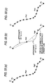
- Fig. 30 two reference points (P 4 , P x ) are set and travel time between the reference points is transmitted by data shown in Figs. 31(a), 31(b), and 31(c) .
- Fig. 31(a) shows node series information for specifying a traffic section including the two reference points.
- Fig. 31(b) shows road additional information similar to that of Fig. 21(b) explained in Sixth Embodiment.
- Fig. 31(c) shows necessary time information displaying travel time, describing a start end side node number (P 4 ), a finish end side road number (P x ) and travel time therebetween.
- the road section can be specified by map matching and the travel time between the reference points can be recognized from the necessary time information.
- Fig. 32 shows a position information transmitting/receiving apparatus 10 receiving and reproducing position information, further, generating and transmitting position information informing event occurrence.
- the apparatus 10 is provided with a position information receiving portion 11 for receiving position information transmitted from a position information transmitting portion 21 of other apparatus 20, a node series restoring portion 12 for converting shape data included in the position information into a vector data series which is easy to execute map matching, a digital map data base 14 for accumulating digital map data, a map matching portion 13 for specifying a road section represented by the position information by executing map matching, a digital map displaying portion 15 for displaying the road section represented by the position information and an event position, an event inputting portion 16 for inputting information of an event which occurs, a position information converting portion 17 for generating position information for transmitting an even occurring position and a position information transmitting portion 18 for transmitting the generated position information to a position information receiving portion 22 of the other apparatus 20.
- the position information receiving portion 11 receives the position information and the node series restoring portion 12 converts shape data subjected to data compression by approximation by a function included therein or thinning into a shape vector data series at equal intervals.
- Fig. 33(a) shows a shape vector data series before compression and Fig. 33(b) shows data compressed by thinning and function approximation.
- the node series restoring portion 12 restores a shape data series at equal intervals from data of Fig. 33(b) as shown by Fig. 33(c) .
- the map matching portion 13 detects a road section matched to the restored shape vector data series from map data accumulated in the digital map data base 14, further, specifies an event occurring position of the road section and displays these to the digital map displaying portion 15.
- the position information converting portion 17 when even information is inputted from the event information inputting portion 16, the position information converting portion 17 generates position information for designating the road section including the event occurring position and the even occurring position in the road section and the position information is transmitted from the position information transmitting portion 18.
- nodes included in the road section nodes having a low degree of contributing to map matching are thinned and for such purpose, with regard to an azimuth from a contiguous node to a corresponding node, when a change in an azimuth from the corresponding node to a successive node is equal to or smaller than predetermined angle and a distance from the contiguous node to the corresponding node is less than a predetermined distance, the corresponding node is thinned.
- the node series restoring portion 12 restores data at equal intervals as follows. In this case, data is restored such that the respective interval does not shift from a constant distance A (meter) by ⁇ b (meter) or more.
- an interval between P n-1 (X n-1 , Y n-1 ) and P n (X n , Y n ) is regarded as a straight line and points are generated at an interval of A meter. Such a pattern is shown in Fig. 47 .
- P n1 F(P n1 ')
- P n1 F(P n1 ')
- the compressed data is converted into a coordinate series at equal intervals. Therefore, matching processing of the map matching portion 13 is facilitated.
- the processing of the node series restoring portion 12 may be realized by software or may be realized by hardware formed by IC.
- a data series at equal intervals is restored from a data series subjected to data compression and therefore, the matching processing is facilitated and accuracy of map matching can be promoted.
- Digital map data include a vector series (V) representing a shape of a facility as shown by Fig. 34 , a vector series (X) representing a shape of a prefectural boundary, a vector series (Y) representing a shape of a lake or marsh and a vector series (W) representing a shape of contour lines as shown by Fig. 35 .
- V vector series
- X representing a shape of a prefectural boundary
- Y representing a shape of a lake or marsh
- W vector series representing a shape of contour lines as shown by Fig. 35 .
- Fig. 36 shows shape data representing a shape of a house.
- a shape vector kind is described as house and an identification code of a building or a general house each described as detailed information. Successively, a node total number and respective node coordinates representing a shape of a house are described and an event occurring position is prescribed by a relative distance from a top node position.
- Fig. 37 shows shape data representing a shape of a water area.
- a shape vector kind is described as water area and as detailed information, an identification code of a face expressing water area such as lake or a line expressing water area such as river is described. The other is the same as that in the case of a shape of a house.
- Fig. 38 shows shape data representing a shape of an administrative boundary.
- a shape vector kind is described as administrative boundary and as detailed information, an identification code of a prefectural boundary, a city boundary, or town boundary is described.
- Fig. 39 shows shape data representing a shape of a contour line.
- a shape vector kind is described as contour line and as detailed information, an identification code of contour line meters above sea level is described.
- the transmitting side sets three reference points (event point 1, event point 2, event point 3) and transmits to the receiving side, shape data of a road section (map matching data 1) including the event point 1, data of a distance r 1 and an azimuth ⁇ 1 from the event point 1 to the reproduced position, shape data of a road section (map matching data 2) including the event point 2, data of a distance r 2 and an azimuth ⁇ 2 from the event point 2 to the reproduced position, as well as, shape data of a road section (map matching data 3) including the event point 3 and data of a distance r 3 and an azimuth ⁇ 3 from the event point 3 to the reproduced position.
- the reproduced position is reproduced by a procedure shown in Fig. 41 .
- the event point 2 is specified from the map matching data 2
- a spot P 2 disposed at the distance r 2 and the azimuth ⁇ 2 from the event point 2 is calculated
- the event point 3 is specified from the map matching data 3 and the spot P 3 disposed at the distance and r 3 and the azimuth ⁇ 3 from the event point 3 is calculated.
- the three event points may be set on a single road (map matching data).
- the reproduced position viewed from the respective event point can be expressed by using reference data ( ⁇ x n , ⁇ y n ) of an x coordinate and a y coordinate.
- the reproduced position is reproduced by a procedure shown in Fig. 43 .
- step 502 and step 503 are repeated and the spot P 2 at ⁇ x 2 , ⁇ y 2 , from the event point 2 and the spot P 3 at ⁇ x 3 , ⁇ y 3 , from the event point 3 are calculated.
- map matching data other than that of road, there can also be utilized vector series representing a shape of a facility explained in Third Embodiment, vector series representing a shape of a prefectural boundary, vector series representing a shape of a lake or marsh, or a vector series representing a shape of a contour line.
- the reference points can be specified with high accuracy on a digital map of its own and therefore, by the relative information from the reference points, the target position can be calculated statistically.
- coordinates data of respective nodes included in shape data are represented by absolute values or relative values of longitude and latitude data
- the coordinates data of the respective nodes may be represented by using other parameters.
- a distance of a straight line P j-1 ⁇ P j is designated by notation L j
- an absolute azimuth (angle in clockwise direction with north as a reference) of the straight line P j-1 ⁇ P j is designated by notation ⁇ j-1
- a distance of a straight line P j ⁇ P j+1 is designated by notation L j+1
- an absolute azimuth of the straight line P ⁇ P j+1 is designated by notation ⁇ j
- the node P j can be specified by using the distance L j from the preceding node P j-1 and the absolute azimuth ⁇ j-1 .
- L j and ⁇ j-1 can be calculated from xy coordinate values of P j-1 and P j by the following equations.
- the node P j+1 can similarly be specified by using the distance L j+1 from the preceding node P j and the absolute azimuth ⁇ j .
- the node P j+1 can also be specified by using the distance L j+1 and an argument from the preceding node P j , that is, an azimuth difference ⁇ j between the absolute azimuth ⁇ j of P j ⁇ P j+1 and the absolute azimuth ⁇ j-1 of P j-1 ⁇ P j .
- the argument ⁇ j can be calculated from respective coordinate values of P j-1 , P j and P j+1 by the following equation.
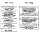
- Figs. 50(a) , 50(b), and 50(c) exemplify transmitted data representing node series information included in shape data by using a distance and an argument from a preceding node.
- the transmission data of Fig. 50(a) includes data of interpolation points #1 through #a between a node p 1 and a node p 2 and the data of the interpolation points are constituted by data of distances and arguments from preceding nodes or preceding interpolation points.
- the node p 1 includes data of absolute coordinates (longitude, latitude) representing a position and an absolute azimuth in a intercept direction (absolute azimuth of a straight line connecting p 1 and the interpolation point #1).
- data of the interpolation point #1 includes an argument data representing an argument difference between an absolute azimuth of a straight line extending from the interpolation point #1 to the interpolation point #2 and the absolute azimuth in the intercept direction
- distance data from p 1 to the interpolation point #1 and data of the interpolation point #2 is similarly constituted by using an argument data of an absolute azimuth of a straight line extended from the interpolation point #2 to the interpolation point #3 and the absolute azimuth of the straight line extended from the interpolation point #1 to the interpolation point #2 and distance data from the interpolation point #1 to the interpolation point #2.
- data of respective nodes excluding the node p 1 at the start end are constituted by distances and arguments from preceding nodes.
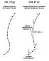
- Figs. 51(a) and 51(b) schematically show a shape (a) of an object road section of original map data and a coordinate series (b) representing the shape by distances and arguments from preceding nodes. Further, as shown by F igs. 51 (a) and 51(b) , the nodes capable of reproducing the shape of the object road section by a smaller number from the original map data of the object road section may be resampled and the resampled nodes may be expressed by the distances and arguments from the preceding nodes.
- Fig. 52 schematically shows a map matching processing on the receiving side receiving the transmitted data.
- map matching on a digital map of its own, firstly, candidate points in correspondence with a start end node p 1 of shape data are set. For that purpose, n pieces of candidates are set on n pieces of contiguous nodes substantially within 200 m from a latitude and longitude data position of the start end node p 1 .
- a point P j+1,1 advanced from a current candidate point P j,1 of respective road by a distance L j of an interval p j ⁇ p j+1 of shape data along the road there are calculated an angle ⁇ j,1 made by a straight line connecting P j-1,1 ⁇ P j,1 and a straight line connecting P j,1 ⁇ P j+1,1 and a difference
- ⁇ j , 1 ⁇ ⁇ D 1 + ⁇ ⁇ ⁇ ⁇ ⁇ ⁇ j , 1
- the candidate point P j,1 is moved to the candidate point P j+1,1 .
- Such a processing is repeated for all of the candidate points, further, a similar processing is executed for all of nodes included in the shape data.
- a candidate having the least operation value ⁇ i is selected as the object load.
- map matching processing by using "distance L 1 from the preceding node" included in shape data, a successive candidate point can easily be calculated, further, the evaluation value can be calculated by directly using "relative azimuth” included in the shape data. Therefore, processing load of the map matching on the receiving side is alleviated.
- the present invention is based on Japanese Patent Applications No. 2000-375320 filed on December 8, 2000 , and No. 2001-220062 filed on July 19, 2001 , which are incorporated herein by references.
- positions of the digital map can efficiently and accurately be transmitted.
- a transmitting method for approximating a shape data series by a function or displaying shape data of a double-streaked line by an offset distance a data amount can be reduced and a data transmission efficiency can be promoted.
- a transmitting method for displaying a relative distance up to an event position by setting a reference point at a crossroads or the like in a road section, or prescribing an event position by a node number accuracy of specifying the event position on the receiving side can be promoted.
- a direction of advancing a vehicle influenced by an event can be specified.
- a matching efficiency on the receiving side can be promoted.
- travel time can be transmitted, further, data can be transmitted in the form of not infringing copyright of map data.
- the invention is applicable also to transmission of vector data other than that of a road, further, a position outside of a road on a digital map can also be transmitted.
Applications Claiming Priority (4)
| Application Number | Priority Date | Filing Date | Title |
|---|---|---|---|
| JP2000375320 | 2000-12-08 | ||
| JP2001220062A JP5041638B2 (ja) | 2000-12-08 | 2001-07-19 | デジタル地図の位置情報伝達方法とそれに使用する装置 |
| EP05020541A EP1632750A1 (fr) | 2000-12-08 | 2001-12-07 | Methode et dispositif de transmission d'information de position pour cartes numériques |
| EP01999786A EP1256781A4 (fr) | 2000-12-08 | 2001-12-07 | Procede de transmission d'informations de position sur une carte numerique et dispositif afferent |
Related Parent Applications (2)
| Application Number | Title | Priority Date | Filing Date |
|---|---|---|---|
| EP01999786.5 Division | 2001-12-07 | ||
| EP05020541.8 Division | 2005-09-21 |
Publications (2)
| Publication Number | Publication Date |
|---|---|
| EP2287566A1 true EP2287566A1 (fr) | 2011-02-23 |
| EP2287566B1 EP2287566B1 (fr) | 2012-11-07 |
Family
ID=26605563
Family Applications (8)
| Application Number | Title | Priority Date | Filing Date |
|---|---|---|---|
| EP10181068A Expired - Lifetime EP2287565B1 (fr) | 2000-12-08 | 2001-12-07 | Procédé pour la transmission d'informations de position sur une carte numérique et appareil correspondant |
| EP05020541A Withdrawn EP1632750A1 (fr) | 2000-12-08 | 2001-12-07 | Methode et dispositif de transmission d'information de position pour cartes numériques |
| EP10181053.9A Expired - Lifetime EP2287564B1 (fr) | 2000-12-08 | 2001-12-07 | Procédé de transmission d'informations de position sur une carte et son appareil |
| EP01999786A Withdrawn EP1256781A4 (fr) | 2000-12-08 | 2001-12-07 | Procede de transmission d'informations de position sur une carte numerique et dispositif afferent |
| EP10181076A Expired - Lifetime EP2287566B1 (fr) | 2000-12-08 | 2001-12-07 | Procédé de transmission d'informations de position sur une carte et son appareil |
| EP09153536.9A Expired - Lifetime EP2077434B1 (fr) | 2000-12-08 | 2001-12-07 | Procédé pour la transmission d'informations de position sur une carte numérique et appareil correspondant |
| EP10181023.2A Expired - Lifetime EP2306150B1 (fr) | 2000-12-08 | 2001-12-07 | Procédé pour la transmission d'informations de position sur une carte numérique et appareil correspondant |
| EP09153534.4A Expired - Lifetime EP2077433B1 (fr) | 2000-12-08 | 2001-12-07 | Procédé pour la transmission d'informations de position sur une carte numérique et appareil correspondant |
Family Applications Before (4)
| Application Number | Title | Priority Date | Filing Date |
|---|---|---|---|
| EP10181068A Expired - Lifetime EP2287565B1 (fr) | 2000-12-08 | 2001-12-07 | Procédé pour la transmission d'informations de position sur une carte numérique et appareil correspondant |
| EP05020541A Withdrawn EP1632750A1 (fr) | 2000-12-08 | 2001-12-07 | Methode et dispositif de transmission d'information de position pour cartes numériques |
| EP10181053.9A Expired - Lifetime EP2287564B1 (fr) | 2000-12-08 | 2001-12-07 | Procédé de transmission d'informations de position sur une carte et son appareil |
| EP01999786A Withdrawn EP1256781A4 (fr) | 2000-12-08 | 2001-12-07 | Procede de transmission d'informations de position sur une carte numerique et dispositif afferent |
Family Applications After (3)
| Application Number | Title | Priority Date | Filing Date |
|---|---|---|---|
| EP09153536.9A Expired - Lifetime EP2077434B1 (fr) | 2000-12-08 | 2001-12-07 | Procédé pour la transmission d'informations de position sur une carte numérique et appareil correspondant |
| EP10181023.2A Expired - Lifetime EP2306150B1 (fr) | 2000-12-08 | 2001-12-07 | Procédé pour la transmission d'informations de position sur une carte numérique et appareil correspondant |
| EP09153534.4A Expired - Lifetime EP2077433B1 (fr) | 2000-12-08 | 2001-12-07 | Procédé pour la transmission d'informations de position sur une carte numérique et appareil correspondant |
Country Status (11)
| Country | Link |
|---|---|
| US (3) | US6931319B2 (fr) |
| EP (8) | EP2287565B1 (fr) |
| JP (1) | JP5041638B2 (fr) |
| KR (1) | KR20030070051A (fr) |
| CN (2) | CN101551251B (fr) |
| AU (1) | AU2002222591A1 (fr) |
| CA (1) | CA2428347C (fr) |
| DK (1) | DK2287566T3 (fr) |
| ES (2) | ES2411131T3 (fr) |
| MY (2) | MY154963A (fr) |
| WO (1) | WO2002046697A1 (fr) |
Cited By (2)
| Publication number | Priority date | Publication date | Assignee | Title |
|---|---|---|---|---|
| CN106128275A (zh) * | 2016-08-24 | 2016-11-16 | 鞍钢集团矿业有限公司 | 一种模拟露天转井采岩体垮落及坑底防水试验装置及方法 |
| CN106128268A (zh) * | 2016-08-24 | 2016-11-16 | 鞍钢集团矿业有限公司 | 一种实际矿体挖掘的模拟装置及方法 |
Families Citing this family (73)
| Publication number | Priority date | Publication date | Assignee | Title |
|---|---|---|---|---|
| JP5041638B2 (ja) | 2000-12-08 | 2012-10-03 | パナソニック株式会社 | デジタル地図の位置情報伝達方法とそれに使用する装置 |
| FR2826292B1 (fr) * | 2001-06-22 | 2004-01-23 | Rhodia Chimie Sa | Emulsions huile dans huile comprenant une silicone, dispersions de telles emulsions et utilisation |
| CN100383834C (zh) * | 2002-08-28 | 2008-04-23 | 谢开章 | 城市地图及公交车站站牌 |
| US6925380B1 (en) * | 2002-10-30 | 2005-08-02 | Acuere Technologies Corporation | Navigation control system |
| JP2004264326A (ja) * | 2003-01-22 | 2004-09-24 | Matsushita Electric Ind Co Ltd | 形状情報符号化方法及び装置、形状情報復号化方法及び装置、並びにプログラム |
| JP2004280521A (ja) * | 2003-03-17 | 2004-10-07 | Matsushita Electric Ind Co Ltd | プローブカーシステムでの走行軌跡の伝送方法と装置 |
| EP1632925A1 (fr) * | 2003-06-11 | 2006-03-08 | Matsushita Electric Industrial Co., Ltd. | Procede et dispositif de compression d'informations de position d'une carte numerique |
| DE10337621B4 (de) * | 2003-08-16 | 2007-10-25 | Daimlerchrysler Ag | Verfahren zur Aktualisierung einer digitalen Karte |
| JP4543637B2 (ja) * | 2003-08-26 | 2010-09-15 | 三菱電機株式会社 | 地図情報処理装置 |
| AT500123B1 (de) * | 2003-08-28 | 2007-01-15 | Oesterreichisches Forschungs U | Verfahren und anordnung zur ermittlung von wegen von verkehrsteilnehmern |
| JP2005121518A (ja) * | 2003-10-17 | 2005-05-12 | Matsushita Electric Ind Co Ltd | 経路情報の伝達方法と装置 |
| JP4506862B2 (ja) * | 2004-04-05 | 2010-07-21 | ソニー株式会社 | ナビゲーション装置、およびデータ処理方法、並びにコンピュータ・プログラム |
| JP2005321370A (ja) * | 2004-04-05 | 2005-11-17 | Sony Corp | ナビゲーション装置、およびデータ処理方法、並びにコンピュータ・プログラム |
| JP3875697B2 (ja) * | 2004-05-06 | 2007-01-31 | 松下電器産業株式会社 | 車載情報処理装置 |
| KR100628592B1 (ko) | 2004-08-31 | 2006-09-26 | 한국과학기술원 | 위치기반서비스를 위한 의미숙성 방식의 위치정보저장시스템 및 그 방법 |
| KR100674506B1 (ko) * | 2005-06-01 | 2007-01-25 | 주식회사 현대오토넷 | 원터치 맵매칭 보정 기능을 가지는 네비게이션 시스템 및그 방법 |
| BRPI0514811A (pt) * | 2005-07-07 | 2008-06-24 | Matsushita Electric Ind Co Ltd | aparelho para correção de informações de mapa, método para correção de informações de mapa, programa, e, aparelho fornecedor de informações e aparelho de aquisição de informações utilizando aparelho para correção de informações de mapa |
| WO2007007377A1 (fr) * | 2005-07-07 | 2007-01-18 | Matsushita Electric Industrial Co., Ltd. | Dispositif fournissant des informations de position et dispositif de terminal utilisant les informations de position |
| JP4363371B2 (ja) * | 2005-07-08 | 2009-11-11 | ブラザー工業株式会社 | 画像形成データ生成装置、その方法、及び、そのプログラム |
| KR100782822B1 (ko) * | 2005-10-18 | 2007-12-06 | 삼성전자주식회사 | 위치 정보 제공 방법 및 장치, 위치 정보 처리 방법 및장치 |
| DE102006004130B4 (de) * | 2006-01-27 | 2012-02-16 | Audi Ag | Verfahren zur Bestimmung eines zukünftigen Straßenverlaufs durch Kommunikaiton zwischen Kraftfahrzeugen |
| DE502006007840D1 (de) * | 2006-06-29 | 2010-10-21 | Navigon Ag | Verfahren zur automatischen, rechnergestützten Bestimmung einer für Fahrzeuge befahrbaren Route |
| JP4694443B2 (ja) * | 2006-08-17 | 2011-06-08 | 本田技研工業株式会社 | ナビサーバ、ナビ装置およびナビシステム |
| US10605610B2 (en) * | 2007-04-09 | 2020-03-31 | Ian Cummings | Apparatus and methods for reducing data transmission in wireless client-server navigation systems |
| CN101680765B (zh) * | 2007-05-11 | 2012-05-30 | 皇家飞利浦电子股份有限公司 | 用于将人员引导到目的地的方法和设备 |
| TW200900655A (en) * | 2007-06-21 | 2009-01-01 | Mitac Int Corp | Navigation device and method calibrated by map position-matching |
| JP4345897B2 (ja) * | 2007-07-05 | 2009-10-14 | 本田技研工業株式会社 | ナビ装置、ナビシステム |
| CN101082501B (zh) * | 2007-07-13 | 2011-02-09 | 瑞典维方达软件技术有限公司 | 基于相对坐标定位的实时地图匹配方法及系统 |
| US10083607B2 (en) | 2007-09-07 | 2018-09-25 | Green Driver, Inc. | Driver safety enhancement using intelligent traffic signals and GPS |
| US20130131980A1 (en) * | 2007-09-07 | 2013-05-23 | On Time Systems, Inc. | Resolving gps ambiguity in electronic maps |
| US9043138B2 (en) * | 2007-09-07 | 2015-05-26 | Green Driver, Inc. | System and method for automated updating of map information |
| US9852624B2 (en) | 2007-09-07 | 2017-12-26 | Connected Signals, Inc. | Network security system with application for driver safety system |
| CN102016508B (zh) | 2008-04-01 | 2014-04-09 | 德卡尔塔公司 | 使用路径id在客户端和服务器端之间传送路径 |
| US9134133B2 (en) | 2008-05-30 | 2015-09-15 | Here Global B.V. | Data mining to identify locations of potentially hazardous conditions for vehicle operation and use thereof |
| US10648817B2 (en) * | 2008-05-30 | 2020-05-12 | Here Global B.V. | Data mining in a digital map database to identify speed changes on upcoming curves along roads and enabling precautionary actions in a vehicle |
| US20090299616A1 (en) * | 2008-05-30 | 2009-12-03 | Navteq North America, Llc | Data mining in a digital map database to identify intersections located over hills and enabling precautionary actions in a vehicle |
| US8698649B2 (en) | 2008-05-30 | 2014-04-15 | Navteq B.V. | Data mining in a digital map database to identify decreasing radius of curvature along roads and enabling precautionary actions in a vehicle |
| US9182241B2 (en) | 2008-05-30 | 2015-11-10 | Here Global B.V. | Data mining in a digital map database to identify unusually narrow lanes or roads and enabling precautionary actions in a vehicle |
| US8775073B2 (en) * | 2008-05-30 | 2014-07-08 | Navteq B.V. | Data mining in a digital map database to identify insufficient merge lanes along roads and enabling precautionary actions in a vehicle |
| US8466810B2 (en) | 2008-05-30 | 2013-06-18 | Navteq B.V. | Data mining in a digital map database to identify intersections located at hill bottoms and enabling precautionary actions in a vehicle |
| US9121716B2 (en) * | 2008-05-30 | 2015-09-01 | Here Global B.V. | Data mining in a digital map database to identify insufficient superelevation along roads and enabling precautionary actions in a vehicle |
| US8688369B2 (en) | 2008-05-30 | 2014-04-01 | Navteq B.V. | Data mining in a digital map database to identify blind intersections along roads and enabling precautionary actions in a vehicle |
| KR101049817B1 (ko) * | 2008-10-06 | 2011-07-15 | 엔에이치엔(주) | 이종 장치에 관심 지점 정보를 제공하는 방법 및 그 시스템 |
| KR200465479Y1 (ko) * | 2008-11-26 | 2013-02-21 | 주식회사 메닉스 | 스타일러스 펜 |
| DE102010002093B4 (de) * | 2009-06-03 | 2024-03-14 | Continental Automotive Technologies GmbH | C2X-Kommunikation mit reduzierter Datenmenge |
| US10198942B2 (en) | 2009-08-11 | 2019-02-05 | Connected Signals, Inc. | Traffic routing display system with multiple signal lookahead |
| CN101876549B (zh) * | 2010-01-25 | 2013-04-10 | 青岛海信移动通信技术股份有限公司 | 一种通过地理位置进行导航的方法和移动终端 |
| JP2011179883A (ja) * | 2010-02-26 | 2011-09-15 | Fujitsu Ten Ltd | ナビゲーションシステム、車載機、プログラム、及び、ナビゲーション方法 |
| CN102252685A (zh) * | 2010-05-21 | 2011-11-23 | 科菱航睿空间信息技术有限公司 | 导航电子地图数据处理方法及基于该处理方法的存储方法 |
| JP5511534B2 (ja) * | 2010-06-16 | 2014-06-04 | 三菱電機株式会社 | 地図情報処理装置 |
| GB201018815D0 (en) * | 2010-11-08 | 2010-12-22 | Tomtom Int Bv | High-definition weather for improved routing and navigation systems |
| CN102542901B (zh) * | 2010-12-17 | 2015-04-08 | 上海博泰悦臻电子设备制造有限公司 | 用于电子地图的线段抽稀装置及其方法 |
| KR101397710B1 (ko) * | 2011-02-08 | 2014-05-23 | 주식회사 팬택 | 위치 기반 데이터 제공 장치 및 방법 |
| EP2500887B1 (fr) * | 2011-03-17 | 2020-09-09 | Harman Becker Automotive Systems GmbH | Description d'un segment de route au moyen de la norme ISO 17572-3 |
| CN103492837B (zh) * | 2011-04-11 | 2016-04-27 | 歌乐株式会社 | 位置计算方法和位置计算装置 |
| US8718932B1 (en) * | 2011-06-01 | 2014-05-06 | Google Inc. | Snapping GPS tracks to road segments |
| EP2602591B1 (fr) * | 2011-12-06 | 2016-04-20 | Telenav GmbH | Procédé de stockage simplifié de données représentant des formes |
| CN103838240B (zh) * | 2012-11-27 | 2018-02-27 | 联想(北京)有限公司 | 控制方法和电子设备 |
| DE102012223780A1 (de) * | 2012-12-19 | 2014-06-26 | Bayerische Motoren Werke Aktiengesellschaft | Verfahren und System zum Erzeugen von Verkehrsinformationen für mindestens ein Fahrzeug |
| DE102014221777A1 (de) * | 2014-10-27 | 2016-04-28 | Robert Bosch Gmbh | Verfahren und Vorrichtung zum Betreiben eines Fahrzeugs |
| DE112017001917T5 (de) * | 2016-04-06 | 2018-12-13 | Mitsubishi Electric Corporation | Kartendaten-Erzeugungssystem und Verfahren zur Erzeugung von Kartendaten |
| CN107655487B (zh) * | 2016-07-25 | 2020-05-08 | 高德软件有限公司 | 一种路段方向识别方法及装置 |
| JP6583322B2 (ja) | 2017-03-17 | 2019-10-02 | カシオ計算機株式会社 | 位置推定装置、位置推定方法及びプログラム |
| KR102612960B1 (ko) * | 2018-01-23 | 2023-12-13 | 삼성전자주식회사 | 지도 수신 방법 및 이를 위한 장치 |
| JP7190813B2 (ja) * | 2018-01-31 | 2022-12-16 | 三菱電機株式会社 | 地図データ生成プログラム、コンピュータ読取可能な記録媒体及び地図データ生成装置 |
| JP6633125B2 (ja) * | 2018-04-26 | 2020-01-22 | 株式会社Vip | 車載装置、判定システム、プログラム及び判定方法 |
| DE102018208207A1 (de) * | 2018-05-24 | 2019-11-28 | Bayerische Motoren Werke Aktiengesellschaft | Steuerung eines Kraftfahrzeugs |
| DE102018005869A1 (de) * | 2018-07-25 | 2020-01-30 | Zf Active Safety Gmbh | System zur Erstellung eines Umgebungsmodells eines Fahrzeugs |
| JP2020101466A (ja) * | 2018-12-21 | 2020-07-02 | 株式会社クボタ | 圃場形状生成システム及び圃場形状生成装置 |
| CN109947890A (zh) * | 2019-03-27 | 2019-06-28 | 重庆卡佐科技有限公司 | 地图实时轨迹的绘制动画实现方法以及装置 |
| CN111556581B (zh) * | 2020-04-21 | 2024-01-19 | 上海海事大学 | 消除隐藏与暴露终端及实施定位的介质访问控制方法 |
| CN112835080B (zh) * | 2021-01-21 | 2024-03-19 | 成都路行通信息技术有限公司 | 车辆静止状态的轨迹修复方法、装置及电子设备 |
| CN115602041B (zh) * | 2021-07-09 | 2024-04-09 | 华为技术有限公司 | 信息生成方法和装置、信息使用方法和装置 |
Citations (4)
| Publication number | Priority date | Publication date | Assignee | Title |
|---|---|---|---|---|
| US5406642A (en) * | 1988-12-23 | 1995-04-11 | Nec Corporation | Image matching method using direction sensitivity and vector smoothing functions for correcting matches |
| US5488559A (en) * | 1993-08-02 | 1996-01-30 | Motorola, Inc. | Map-matching with competing sensory positions |
| WO1998054682A1 (fr) * | 1997-05-30 | 1998-12-03 | Booth David S | Generation et transmission d'informations liees au deplacement et en fonction d'un emplacement geographique |
| EP0921509A2 (fr) * | 1997-10-16 | 1999-06-09 | Navigation Technologies Corporation | Système et méthode de mise à jour, d'amélioration et d'affinage d'une base de données géographique par rétroaction |
Family Cites Families (202)
| Publication number | Priority date | Publication date | Assignee | Title |
|---|---|---|---|---|
| US4196474A (en) | 1974-02-11 | 1980-04-01 | The Johns Hopkins University | Information display method and apparatus for air traffic control |
| DE2408333C2 (de) | 1974-02-21 | 1985-05-23 | Robert Bosch Gmbh, 7000 Stuttgart | Einrichtung zur Abstandsmessung |
| DE2431630C2 (de) | 1974-07-02 | 1985-06-27 | Robert Bosch Gmbh, 7000 Stuttgart | Optoelektronischer Aufnehmer |
| DE2631543A1 (de) | 1976-07-14 | 1978-01-19 | Blaupunkt Werke Gmbh | Zielfuehrungssystem fuer kraftfahrzeuge |
| US4151656A (en) | 1977-09-12 | 1979-05-01 | Eastman Kodak Company | Manually manipulatable gyroscope-stabilized indicating apparatus and method for its use |
| DE2853978A1 (de) | 1978-12-14 | 1980-07-03 | Bosch Gmbh Robert | Entfernungsmesser |
| DE3334093A1 (de) | 1983-09-21 | 1985-04-11 | Robert Bosch Gmbh, 7000 Stuttgart | Verfahren und schaltung zur ermittlung des verbauchsoptimalen getriebeganges eines kraftfahrzeugantriebes |
| DE3345818A1 (de) | 1983-12-17 | 1985-06-27 | Robert Bosch Gmbh, 7000 Stuttgart | Verfahren zur ermittlung von stoerfeldern in fahrzeugen mit einem elektronischen kompass |
| DE3345712A1 (de) | 1983-12-17 | 1985-06-27 | Robert Bosch Gmbh, 7000 Stuttgart | Magnetometer mit zeitverschluesselung zur messung von magnetfeldern |
| DE3422490A1 (de) | 1984-06-16 | 1985-12-19 | Robert Bosch Gmbh, 7000 Stuttgart | Verfahren zur korrektur von winkelfehlern bei einem elektronischen kompass in fahrzeugen |
| DE3422491A1 (de) | 1984-06-16 | 1985-12-19 | Robert Bosch Gmbh, 7000 Stuttgart | Verfahren zur ermittlung der fahrtrichtung eines fahrzeuges mit elektronischem kompass |
| DE3532016A1 (de) | 1985-09-07 | 1987-03-19 | Bosch Gmbh Robert | Vorrichtung zur messung von entfernung und richtung von fahrzielen auf strassenkarten |
| DE3532768A1 (de) | 1985-09-13 | 1987-03-19 | Bosch Gmbh Robert | Schaltungsanordnung zur addition, speicherung und wiedergabe elektrischer zaehlimpulse |
| DE3534480A1 (de) | 1985-09-27 | 1987-04-02 | Bosch Gmbh Robert | Verfahren zur bestimmung des einbauortes eines magnetfeldsensors in kraftfahrzeugen |
| CA1295737C (fr) * | 1986-03-14 | 1992-02-11 | Akira Ichikawa | Appareil d'affichage des trajets de voyage |
| DE3609839A1 (de) | 1986-03-22 | 1987-09-24 | Bosch Gmbh Robert | Vorrichtung zum selbsttaetigen ausloesen von insassenschutzvorrichtungen bei einem unfall |
| ES2019912B3 (es) * | 1986-09-25 | 1991-07-16 | Siemens Ag | Dispositivo de navegacion para un vehiculo. |
| JPH07107548B2 (ja) * | 1986-10-13 | 1995-11-15 | 株式会社日立製作所 | 人工衛星による測位方法 |
| US4807127A (en) * | 1986-12-10 | 1989-02-21 | Sumitomo Electric Industries, Ltd. | Vehicle location detecting system |
| JPS63150618A (ja) * | 1986-12-15 | 1988-06-23 | Honda Motor Co Ltd | 走行経路表示装置 |
| DE3644683A1 (de) | 1986-12-30 | 1988-07-14 | Bosch Gmbh Robert | Navigationsverfahren fuer fahrzeuge mit elektronischem kompass |
| DE3644681A1 (de) | 1986-12-30 | 1988-07-14 | Bosch Gmbh Robert | Navigationsverfahren fuer fahrzeuge mit elektronischem kompass |
| DE3700552B4 (de) | 1987-01-10 | 2005-06-02 | Robert Bosch Gmbh | Verfahren zur Ausgabe von Wegeinformationen für Fahrer von Landfahrzeugen und Informationsausgabesystem |
| DE3712360A1 (de) | 1987-04-11 | 1988-10-27 | Bosch Gmbh Robert | Verfahren und vorrichtung zur auswahl oder eingabe des zieles bei einem navigationssystem im kraftfahrzeug |
| DE3715007A1 (de) * | 1987-05-06 | 1988-11-17 | Bosch Gmbh Robert | Verfahren und vorrichtung zur kursbestimmung eines landfahrzeugs |
| DE3719017A1 (de) * | 1987-06-06 | 1988-12-15 | Bosch Gmbh Robert | Verfahren und vorrichtung zur bestimmung einer fahrtroute zwischen einem startpunkt und einem zielpunkt |
| CA1326273C (fr) * | 1987-08-07 | 1994-01-18 | Akira Iihoshi | Dispositif d'affichage de parcours |
| DE3737972A1 (de) * | 1987-11-07 | 1989-05-24 | Messerschmitt Boelkow Blohm | Helm-lagedarstellungsgeraet |
| US5184123A (en) | 1988-03-03 | 1993-02-02 | Robert Bosch Gmbh | Method of and arrangement for representing travel guiding information |
| DE3810177C2 (de) | 1988-03-25 | 1999-06-17 | Bosch Gmbh Robert | Rundfunkempfänger, insbesondere Fahrzeugempfänger |
| JPH07119617B2 (ja) * | 1988-07-05 | 1995-12-20 | マツダ株式会社 | 車両用ナビゲーシヨン装置 |
| US5067082A (en) * | 1988-08-11 | 1991-11-19 | Aisin Aw Co., Ltd. | Navigation apparatus |
| DE3843143A1 (de) | 1988-12-22 | 1990-06-28 | Bosch Gmbh Robert | Sensor zur bestimmung der winkelgeschwindigkeit |
| DE3939410A1 (de) | 1989-11-29 | 1991-06-06 | Bosch Gmbh Robert | Sensor |
| US5193214A (en) | 1989-12-29 | 1993-03-09 | Robert Bosch Gmbh | Vehicular radio receiver with standard traffic problem database |
| US5095532A (en) | 1989-12-29 | 1992-03-10 | Robert Bosch Gmbh | Method and apparatus for route-selective reproduction of broadcast traffic announcements |
| DE4008460A1 (de) | 1990-03-16 | 1991-09-19 | Bosch Gmbh Robert | Navigationssystem |
| US5279040A (en) | 1990-05-18 | 1994-01-18 | Robert Bosch Gmbh | Fluid-based acceleration and tilt sensor |
| DE4016471A1 (de) | 1990-05-22 | 1991-11-28 | Bosch Gmbh Robert | Mikromechanischer neigungssensor |
| JPH0434653A (ja) * | 1990-05-31 | 1992-02-05 | Toshiba Corp | 図面処理装置 |
| US5173691A (en) | 1990-07-26 | 1992-12-22 | Farradyne Systems, Inc. | Data fusion process for an in-vehicle traffic congestion information system |
| US5182555A (en) | 1990-07-26 | 1993-01-26 | Farradyne Systems, Inc. | Cell messaging process for an in-vehicle traffic congestion information system |
| US5214757A (en) * | 1990-08-07 | 1993-05-25 | Georesearch, Inc. | Interactive automated mapping system |
| US5177685A (en) | 1990-08-09 | 1993-01-05 | Massachusetts Institute Of Technology | Automobile navigation system using real time spoken driving instructions |
| NL9001810A (nl) * | 1990-08-13 | 1992-03-02 | Philips Nv | Werkwijze voor de positiebepaling van een voertuig, inrichting voor de positiebepaling van een voertuig, alsmede voertuig voorzien van de inrichting. |
| FR2667423B1 (fr) | 1990-09-28 | 1995-05-24 | Sagem | Recepteur de bord d'aide a la navigation automobile. |
| US5867804A (en) * | 1993-09-07 | 1999-02-02 | Harold R. Pilley | Method and system for the control and management of a three dimensional space envelope |
| DE4035370A1 (de) | 1990-11-07 | 1992-05-14 | Bosch Gmbh Robert | Verfahren zur bestimmung des standortes eines landfahrzeugs |
| DE4039887A1 (de) | 1990-12-13 | 1992-06-17 | Bosch Gmbh Robert | Fahrzeugleit- und zielfuehrungssystem |
| DE4106932A1 (de) | 1991-03-05 | 1992-09-10 | Bosch Gmbh Robert | Neigungssensor |
| US5311195A (en) * | 1991-08-30 | 1994-05-10 | Etak, Inc. | Combined relative and absolute positioning method and apparatus |
| DE4129085A1 (de) | 1991-09-02 | 1993-03-04 | Bosch Gmbh Robert | Optischer sensor fuer rotationsbewegungen |
| US6107941A (en) | 1991-10-09 | 2000-08-22 | R. D. Jones, Right Of Way, Inc. | Traffic control system and kit |
| DE4135369A1 (de) | 1991-10-26 | 1993-05-13 | Bosch Gmbh Robert | Testbarer piezoelektrischer beschleunigungssensor |
| US5283575A (en) | 1991-11-08 | 1994-02-01 | Zexel Corporation | System and method for locating a travelling vehicle |
| JPH05173481A (ja) * | 1991-12-25 | 1993-07-13 | Daihatsu Motor Co Ltd | マップマッチングにおける道路認識方法 |
| DE4208277A1 (de) | 1992-03-13 | 1993-09-16 | Bosch Gmbh Robert | Verkehrsrundfunkempfaenger |
| US5396429A (en) | 1992-06-30 | 1995-03-07 | Hanchett; Byron L. | Traffic condition information system |
| DE4230294A1 (de) | 1992-09-10 | 1994-03-17 | Bosch Gmbh Robert | Verfahren zur Auswahl routenrelevante Meldungen bei RDS Radios |
| JP3221746B2 (ja) * | 1992-10-14 | 2001-10-22 | パイオニア株式会社 | ナビゲーション装置 |
| JP3157923B2 (ja) * | 1992-10-20 | 2001-04-23 | パイオニア株式会社 | ナビゲーション装置の距離誤差補正方法 |
| US5332180A (en) | 1992-12-28 | 1994-07-26 | Union Switch & Signal Inc. | Traffic control system utilizing on-board vehicle information measurement apparatus |
| US6208268B1 (en) | 1993-04-30 | 2001-03-27 | The United States Of America As Represented By The Secretary Of The Navy | Vehicle presence, speed and length detecting system and roadway installed detector therefor |
| DE4318109A1 (de) | 1993-06-01 | 1994-12-08 | Bosch Gmbh Robert | Verfahren und Vorrichtung zur Durchführung eines drahtlosen Datenaustausches zwischen einer Feststation und sich bewegenden Objekten |
| DE4318108C1 (de) | 1993-06-01 | 1995-01-05 | Bosch Gmbh Robert | Verfahren zur Durchführung eines drahtlosen Datenaustauschs zwischen einer Feststation und Sende-/Empfangsgeräten |
| JPH06347278A (ja) | 1993-06-10 | 1994-12-20 | Alpine Electron Inc | 車両の存在リンク検出方法 |
| US5504482A (en) | 1993-06-11 | 1996-04-02 | Rockwell International Corporation | Automobile navigation guidance, control and safety system |
| US5515042A (en) | 1993-08-23 | 1996-05-07 | Nelson; Lorry | Traffic enforcement device |
| DE4332945A1 (de) * | 1993-09-28 | 1995-03-30 | Bosch Gmbh Robert | Ortungs- und Navigationsgerät mit Satellitenstützung |
| DE4333357A1 (de) | 1993-09-30 | 1995-04-06 | Bosch Gmbh Robert | Einparkhilfe mit Radsensor |
| US5416711A (en) | 1993-10-18 | 1995-05-16 | Grumman Aerospace Corporation | Infra-red sensor system for intelligent vehicle highway systems |
| DE4410895B4 (de) | 1994-03-29 | 2004-11-25 | Robert Bosch Gmbh | Verfahren und Vorrichtung zum verdeckten Einbau eines Ultraschallsensors in einem Kraftfahrzeug-Außenteil |
| JP3003905B2 (ja) * | 1994-04-20 | 2000-01-31 | 三菱電機株式会社 | 地図表示装置および画像処理方法 |
| DE4415993A1 (de) * | 1994-05-06 | 1995-11-09 | Bosch Gmbh Robert | Korrekturverfahren und Navigationssystem für die Koppelortung eines Kraftfahrzeuges |
| US6321158B1 (en) | 1994-06-24 | 2001-11-20 | Delorme Publishing Company | Integrated routing/mapping information |
| EP0715749B1 (fr) * | 1994-07-04 | 2002-04-17 | Siemens Aktiengesellschaft | Determination de changement de direction d'un vehicule en navigation, dispositif de mise en oeuvre et vehicule equipe du dispositif |
| DE69521783T2 (de) | 1994-08-08 | 2002-04-25 | Siemens Ag | Navigationsvorrichtung für ein landfahrzeug mit mitteln zur erzeugung einer frühzeitigen sprachnachricht mit mehreren elementen, sowie fahrzeug damit |
| JP2674521B2 (ja) | 1994-09-21 | 1997-11-12 | 日本電気株式会社 | 移動体誘導装置 |
| DE4433982C1 (de) | 1994-09-23 | 1995-10-19 | Bosch Gmbh Robert | Vorrichtung zum Auffinden eines verfügbaren Parkplatzes oder Parkhauses |
| US5826212A (en) | 1994-10-25 | 1998-10-20 | Honda Giken Kogyo Kabushiki Kaisha | Current-position map and three dimensional guiding objects displaying device for vehicle |
| US5581259A (en) * | 1994-11-03 | 1996-12-03 | Trimble Navigation Limited | Life for old maps |
| US5659476A (en) | 1994-12-22 | 1997-08-19 | Motorola Inc. | Land vehicle navigation apparatus and method for planning a recovery route |
| US5848374A (en) * | 1995-03-06 | 1998-12-08 | Nippon Telegraph And Telephone Corporation | Map information processing method and apparatus for correlating road location on a road network map |
| HU227907B1 (en) | 1995-03-23 | 2012-05-29 | Deutsche Telekom Mobil | Method and system for determining dynamic traffic information |
| JP3578512B2 (ja) * | 1995-04-21 | 2004-10-20 | 株式会社ザナヴィ・インフォマティクス | 現在位置算出装置およびその距離係数補正方法 |
| JP3578511B2 (ja) * | 1995-04-21 | 2004-10-20 | 株式会社ザナヴィ・インフォマティクス | 現在位置算出装置 |
| DE19516477A1 (de) | 1995-05-05 | 1996-11-07 | Bosch Gmbh Robert | Einrichtung zur Aufbereitung und Ausgabe von Informationen für einen Fahrzeugführer |
| DE19516696A1 (de) | 1995-05-06 | 1996-11-07 | Hans Joachim Dipl Ing Eberhard | Verfahren zur Identifizierung und Kontrolle der Anlieferung und der Rücklieferung von Presseerzeugnissen |
| DE19519488B4 (de) | 1995-05-27 | 2005-03-10 | Bosch Gmbh Robert | Drehratensensor mit zwei Beschleunigungssensoren |
| US5614913A (en) * | 1995-06-07 | 1997-03-25 | Trimble Navigation | Optimization of survey coordinate transformations |
| JP3545839B2 (ja) * | 1995-06-09 | 2004-07-21 | 株式会社ザナヴィ・インフォマティクス | 現在位置算出装置 |
| JPH0914984A (ja) | 1995-06-28 | 1997-01-17 | Aisin Aw Co Ltd | 車両用ナビゲーション装置 |
| DE19526148C2 (de) | 1995-07-07 | 1997-06-05 | Mannesmann Ag | Verfahren und System zur Prognose von Verkehrsströmen |
| KR960042490A (ko) * | 1995-11-09 | 1996-12-21 | 모리 하루오 | 차량용 네비게이션(navigation) 장치 및 그를 위한 기록매체 |
| US6111523A (en) | 1995-11-20 | 2000-08-29 | American Traffic Systems, Inc. | Method and apparatus for photographing traffic in an intersection |
| US5933100A (en) | 1995-12-27 | 1999-08-03 | Mitsubishi Electric Information Technology Center America, Inc. | Automobile navigation system with dynamic traffic data |
| US5862511A (en) * | 1995-12-28 | 1999-01-19 | Magellan Dis, Inc. | Vehicle navigation system and method |
| US5745865A (en) | 1995-12-29 | 1998-04-28 | Lsi Logic Corporation | Traffic control system utilizing cellular telephone system |
| JP3499357B2 (ja) * | 1996-01-31 | 2004-02-23 | 三菱電機株式会社 | 地図帳接合表示方法 |
| JP3174265B2 (ja) * | 1996-04-19 | 2001-06-11 | 三菱電機株式会社 | 交通情報表示装置 |
| DE19616038A1 (de) | 1996-04-23 | 1997-10-30 | Bosch Gmbh Robert | Verfahren und Meßeinrichtung zur Bestimmung der Lage eines Objekts |
| JP3406144B2 (ja) | 1996-04-24 | 2003-05-12 | 株式会社デンソー | 車両用経路案内装置 |
| JP3451162B2 (ja) * | 1996-05-09 | 2003-09-29 | アルパイン株式会社 | ナビゲーション装置及び移動体の現在位置修正方式 |
| US5842146A (en) | 1996-05-10 | 1998-11-24 | Honda Giken Kogyo Kabushiki Kaisha | Method and apparatus of setting clock time and using time data in a vehicle navigation system |
| EP0807803B1 (fr) * | 1996-05-16 | 2005-02-23 | Matsushita Electric Industrial Co., Ltd. | Appareil pour la reproduction d'information de cartes routières, support d'enregistrement et méthode de transmission |
| US6006161A (en) | 1996-08-02 | 1999-12-21 | Aisin Aw Co., Ltd. | Land vehicle navigation system with multi-screen mode selectivity |
| KR100269069B1 (ko) | 1996-08-30 | 2000-10-16 | 모리 하루오 | 차량용네비게이션장치및기억매체 |
| DE19637053C2 (de) | 1996-09-12 | 2000-03-09 | Bosch Gmbh Robert | Verfahren und Vorrichtung zur automatischen Erkennung von Rechts- oder Linksverkehr |
| US6111521A (en) | 1996-09-18 | 2000-08-29 | Mannesmann Vdo Ag | Apparatus for supplying traffic-related information |
| KR100376895B1 (ko) * | 1996-09-20 | 2003-03-19 | 도요다 지도샤 가부시끼가이샤 | 위치 정보 제공 시스템 및 장치 |
| DE19645209B4 (de) * | 1996-11-02 | 2005-07-28 | Robert Bosch Gmbh | Ortungsvorrichtung für ein Kraftfahrzeug mit einem Satellitenempfänger und Ortungsverfahren |
| US5948043A (en) * | 1996-11-08 | 1999-09-07 | Etak, Inc. | Navigation system using GPS data |
| WO1998027529A1 (fr) * | 1996-12-16 | 1998-06-25 | Mannesmann Ag | Procede pour transmettre d'un central d'informations routieres a un terminal monte dans un vehicule des informations routieres qui definissent un trajet d'un vehicule dans un reseau routier, central d'informations routieres et terminal |
| WO1998027530A1 (fr) | 1996-12-16 | 1998-06-25 | Mannesmann Ag | Procede pour transmettre entre un central d'informations routieres et un terminal monte dans un vehicule des informations routieres concernant un trajet recommande d'un vehicule dans un reseau routier, terminal et central d'informations routieres |
| DE19653021A1 (de) | 1996-12-19 | 1998-06-25 | Bosch Gmbh Robert | Vorrichtung zur Ermittlung einer Drehrate |
| EP0885519B1 (fr) * | 1996-12-25 | 2004-05-12 | Casio Computer Co., Ltd. | Systeme et methode servant a traiter des donnees d'image |
| US6230100B1 (en) * | 1997-01-31 | 2001-05-08 | Motorola, Inc. | Method and apparatus for differential scale factor calibration in differential odometry systems integrated with GPS |
| DE19808111B4 (de) * | 1997-02-28 | 2007-04-05 | Aisin AW Co., Ltd., Anjo | Fahrzeugnavigationssystem |
| US5850190A (en) | 1997-03-06 | 1998-12-15 | Sony Corporation | Traffic information pager |
| DE69824218T2 (de) * | 1997-03-07 | 2005-06-23 | Pioneer Electronic Corp. | Navigationsvorrichtung |
| US5974356A (en) | 1997-03-14 | 1999-10-26 | Qualcomm Incorporated | System and method for determining vehicle travel routes and mileage |
| DE19714600B4 (de) | 1997-04-09 | 2004-05-27 | Robert Bosch Gmbh | Ortungsvorrichtung für Fahrzeuge |
| US6021371A (en) | 1997-04-16 | 2000-02-01 | Trimble Navigation Limited | Communication and navigation system incorporating position determination |
| JPH10307037A (ja) | 1997-05-02 | 1998-11-17 | Pioneer Electron Corp | ナビゲーション装置 |
| DE19719780B4 (de) | 1997-05-10 | 2006-09-07 | Robert Bosch Gmbh | Beschleunigungserfassungseinrichtung |
| DE19730452A1 (de) * | 1997-07-16 | 1999-01-21 | Bosch Gmbh Robert | Verfahren zur Selektion von digitalen Verkehrsmeldungen |
| JPH1151679A (ja) | 1997-08-01 | 1999-02-26 | Fujitsu Ten Ltd | ナビゲーション装置 |
| EP0899703B1 (fr) | 1997-08-25 | 2002-10-30 | Texas Instruments France | Système de navigation |
| DE19737256B4 (de) * | 1997-08-27 | 2005-02-24 | Robert Bosch Gmbh | Fahrzeugleit- und Zielführungssystem |
| DE19741033A1 (de) | 1997-09-18 | 1999-03-25 | Bosch Gmbh Robert | Übermitteln von Verkehrsinformationen für den Fahrer eines Fahrzeuges |
| DE19743568A1 (de) | 1997-10-02 | 1999-04-08 | Bosch Gmbh Robert | Winkelmeßgerät |
| DE19747230A1 (de) | 1997-10-25 | 1999-05-12 | Bosch Gmbh Robert | Verfahren zur Berücksichtigung ergänzender Verkehrsinformationen in einer fahrzeugfesten Zielführungseinrichtung |
| DE19748127A1 (de) | 1997-10-31 | 1999-05-06 | Bosch Gmbh Robert | Navigationseinrichtung für Kraftfahrzeuge |
| JP3547300B2 (ja) | 1997-12-04 | 2004-07-28 | 株式会社日立製作所 | 情報交換システム |
| JPH11214068A (ja) | 1998-01-21 | 1999-08-06 | Japan Aviation Electronics Ind Ltd | 多ブロックコネクタ |
| DE19803662C2 (de) * | 1998-01-30 | 1999-12-02 | Siemens Ag | Navigationsgerät und Verfahren zur Positionsbestimmung mittels Koppelnavigation |
| DE19804051B4 (de) | 1998-02-03 | 2004-10-28 | Robert Bosch Gmbh | Entfernungsmeßgerät |
| JPH11242166A (ja) | 1998-02-26 | 1999-09-07 | Canon Inc | 接眼レンズ、ファインダー光学系及びそれを有する光学機器 |
| DE19815035B4 (de) | 1998-03-05 | 2006-06-22 | Volkswagen Ag | Verfahren und Vorrichtung zur Darstellung von Informationen für ein Navigationsgerät |
| DE19809683B4 (de) | 1998-03-06 | 2006-08-10 | Robert Bosch Gmbh | Zusatzgehäuse zur Halterung eines Entfernungsmeßgerätes |
| US6038559A (en) * | 1998-03-16 | 2000-03-14 | Navigation Technologies Corporation | Segment aggregation in a geographic database and methods for use thereof in a navigation application |
| US6192314B1 (en) | 1998-03-25 | 2001-02-20 | Navigation Technologies Corp. | Method and system for route calculation in a navigation application |
| JP3015337B2 (ja) * | 1998-03-30 | 2000-03-06 | 松下電器産業株式会社 | 車両緊急通報システム及び車両緊急通報装置 |
| JP3040973B2 (ja) * | 1998-03-30 | 2000-05-15 | 松下電器産業株式会社 | 車両位置検出方法及び車両緊急通報システム |
| US5990809A (en) | 1998-03-31 | 1999-11-23 | Howard; David M. | Underwater surveying system |
| US6108603A (en) * | 1998-04-07 | 2000-08-22 | Magellan Dis, Inc. | Navigation system using position network for map matching |
| JPH11304512A (ja) * | 1998-04-20 | 1999-11-05 | Sharp Corp | ナビゲーションシステム |
| DE19818473C2 (de) | 1998-04-24 | 2000-03-30 | Siemens Ag | Verfahren zur Bestimmung der Position eines Fahrzeugs |
| JPH11311533A (ja) * | 1998-04-28 | 1999-11-09 | Xanavi Informatics Corp | 経路探索装置 |
| EP1020832A1 (fr) | 1998-04-28 | 2000-07-19 | Robert Bosch Gmbh | Méthode de génération d'un ensemble de locations de référence dans un carte numérique |
| JP3776591B2 (ja) | 1998-05-13 | 2006-05-17 | 株式会社日立製作所 | 地図情報更新方法および装置 |
| DE19823123C2 (de) | 1998-05-23 | 2000-05-25 | Opel Adam Ag | Verfahren zum Betrieb eines Navigationssystems für Kraftfahrzeuge |
| JPH11352880A (ja) * | 1998-06-09 | 1999-12-24 | Mitsubishi Electric Corp | 広域地図と道路図面間のデータリンクおよび検索方法と道路図面管理システム |
| DE19835051A1 (de) | 1998-08-04 | 2000-02-10 | Bosch Gmbh Robert | Einrichtung zur Codierung und zur Decodierung von Orten |
| JP3801358B2 (ja) | 1998-08-06 | 2006-07-26 | アイシン・エィ・ダブリュ株式会社 | 車両用ナビゲーション装置及び方法 |
| DE19836485A1 (de) | 1998-08-12 | 2000-02-17 | Bosch Gmbh Robert | Verfahren zum Bestimmen einer Route von einem Ausgangspunkt zu einem Zielpunkt auf einem Routennetz |
| DE19847013A1 (de) | 1998-10-13 | 2000-04-20 | Bosch Gmbh Robert | Einparkhilfesystem |
| DE19847754A1 (de) | 1998-10-16 | 2000-04-27 | Bosch Gmbh Robert | Navigationsverfahren und Navigationsgerät für Fortbewegungsmittel |
| US6064319A (en) | 1998-10-22 | 2000-05-16 | Matta; David M. | Method and system for regulating switching of a traffic light |
| DE19850066B4 (de) | 1998-10-30 | 2008-05-21 | Robert Bosch Gmbh | Mikromechanischer Neigungssensor |
| JP2000146607A (ja) * | 1998-11-10 | 2000-05-26 | Clarion Co Ltd | ナビゲ−ション装置 |
| WO2000031706A1 (fr) | 1998-11-23 | 2000-06-02 | Nestor, Inc. | Systeme d'evitement de collision pour intersections avec feux de circulation |
| EP2009606B1 (fr) | 1998-11-23 | 2010-10-20 | Integrated Transport Information Services Limited | Système instantané de surveillance de trafic |
| US6333703B1 (en) * | 1998-11-24 | 2001-12-25 | International Business Machines Corporation | Automated traffic mapping using sampling and analysis |
| US6150961A (en) | 1998-11-24 | 2000-11-21 | International Business Machines Corporation | Automated traffic mapping |
| DE19856478C1 (de) | 1998-12-02 | 2000-06-21 | Ddg Ges Fuer Verkehrsdaten Mbh | Parkraumerfassung |
| JP3607516B2 (ja) | 1999-01-20 | 2005-01-05 | 松下電器産業株式会社 | 移動体マップマッチング装置 |
| US6223125B1 (en) | 1999-02-05 | 2001-04-24 | Brett O. Hall | Collision avoidance system |
| SE520822C2 (sv) | 1999-02-17 | 2003-09-02 | Telia Ab | System för presentation av användaranpassad positionsberoende information på terminalutrustning |
| US6236336B1 (en) | 1999-02-24 | 2001-05-22 | Cobra Electronics Corp. | Traffic information warning system with single modulated carrier |
| JP4060974B2 (ja) | 1999-02-25 | 2008-03-12 | 株式会社ザナヴィ・インフォマティクス | 経路誘導装置 |
| EP1035531B1 (fr) * | 1999-03-05 | 2006-04-26 | Hitachi, Ltd. | Système fournissant de l'information pour unités mobiles |
| DE19914540C2 (de) | 1999-03-31 | 2003-12-11 | Bosch Gmbh Robert | Nivelliervorrichtung |
| DE19915212A1 (de) * | 1999-04-03 | 2000-10-05 | Bosch Gmbh Robert | Verfahren und Vorrichtung zur Bestimmung der Position eines Fahrzeugs |
| DE10030455B4 (de) * | 1999-06-21 | 2010-04-08 | Nissan Motor Co., Ltd., Yokohama-shi | Vorrichtung zum Erzeugen von Straßeninformationen aus einer gespeicherten digitalen Kartendatenbank |
| JP3568108B2 (ja) | 1999-07-28 | 2004-09-22 | 松下電器産業株式会社 | デジタル地図の位置情報伝達方法とそれを実施する装置 |
| US20040215387A1 (en) * | 2002-02-14 | 2004-10-28 | Matsushita Electric Industrial Co., Ltd. | Method for transmitting location information on a digital map, apparatus for implementing the method, and traffic information provision/reception system |
| JP3481168B2 (ja) | 1999-08-27 | 2003-12-22 | 松下電器産業株式会社 | デジタル地図の位置情報伝達方法 |
| AU768488B2 (en) | 1999-09-07 | 2003-12-11 | Robert Bosch Gmbh | Method for coding and decoding objects in a road traffic network |
| DE19942522A1 (de) | 1999-09-07 | 2001-03-08 | Bosch Gmbh Robert | Verfahren zur Codierung und Decodierung von Objekten mit Bezug auf ein Verkehrswegenetz |
| US6212473B1 (en) | 1999-09-20 | 2001-04-03 | Ford Global Technologies, Inc. | Vehicle navigation system having inferred user preferences |
| US6674434B1 (en) | 1999-10-25 | 2004-01-06 | Navigation Technologies Corp. | Method and system for automatic generation of shape and curvature data for a geographic database |
| JP3589124B2 (ja) | 1999-11-18 | 2004-11-17 | トヨタ自動車株式会社 | ナビゲーション装置 |
| JP4080123B2 (ja) * | 1999-12-07 | 2008-04-23 | パイオニア株式会社 | ナビゲーションシステム |
| DE19963766A1 (de) | 1999-12-30 | 2001-07-05 | Bosch Gmbh Robert | Verfahren zum Betrieb eines Navigationssystems |
| DE19963765A1 (de) | 1999-12-30 | 2001-07-05 | Bosch Gmbh Robert | Verfahren zum Betrieb eines Navigationssystems |
| DE19963764A1 (de) * | 1999-12-30 | 2001-07-05 | Bosch Gmbh Robert | Verfahren, Bedienteil, Navigationssystem und Schnittstelle zur Darstellung von Ausschnitten einer digitalen Kartenbasis |
| DE10004163A1 (de) | 2000-02-01 | 2001-08-02 | Bosch Gmbh Robert | Navigationssystem und Verfahren zur nutzerspezifischen Anpassung eines Navigationssystems |
| JP3471003B2 (ja) * | 2000-02-02 | 2003-11-25 | 松下電器産業株式会社 | 交差点表示方法およびその地図表示装置並びに記録媒体 |
| US6449557B2 (en) * | 2000-02-14 | 2002-09-10 | Matsushita Electric Industrial Co., Ltd. | Device and method for changing map information |
| DE10016674A1 (de) | 2000-04-04 | 2001-10-18 | Bosch Gmbh Robert | Verfahren zur Ausgabe von Daten in einem Fahrzeug und Fahrerinformationsvorrichtung |
| US6292747B1 (en) | 2000-04-20 | 2001-09-18 | International Business Machines Corporation | Heterogeneous wireless network for traveler information |
| JP3816299B2 (ja) * | 2000-04-28 | 2006-08-30 | パイオニア株式会社 | ナビゲーションシステム |
| DE10021373A1 (de) | 2000-05-02 | 2001-11-08 | Siemens Ag | Verfahren zur Positionsbestimmung und Navigationsgerät |
| DE10030896A1 (de) | 2000-06-23 | 2002-01-03 | Bosch Gmbh Robert | Digitale Straßenkarte und Navigationsverfahren unter Benutzung einer digitalen Straßenkarte |
| DE10033193A1 (de) | 2000-07-07 | 2002-01-17 | Bosch Gmbh Robert | Verfahren und Anordnung zur Codierung, zur Decodierung und/oder zur Übertragung von Ortsinformationen |
| DE10039235C2 (de) | 2000-08-11 | 2003-01-30 | Bosch Gmbh Robert | Verfahren zur Darstellung einer Fahrstrecke |
| WO2002016874A1 (fr) | 2000-08-24 | 2002-02-28 | Siemens Aktiengesellschaft | Procede permettant d'obtenir une representation cartographique, et appareil de navigation y relatif |
| JP5041638B2 (ja) * | 2000-12-08 | 2012-10-03 | パナソニック株式会社 | デジタル地図の位置情報伝達方法とそれに使用する装置 |
| JP4749594B2 (ja) * | 2001-04-27 | 2011-08-17 | パナソニック株式会社 | デジタル地図の位置情報伝達方法 |
| JP3642514B2 (ja) * | 2001-09-13 | 2005-04-27 | 松下電器産業株式会社 | 簡易型交通情報の生成方法と装置 |
| CA2479322A1 (fr) * | 2002-03-28 | 2003-10-23 | Matsushita Electric Industrial Co., Ltd. | Dispositif de correction de donnees de position relative, procede de correction de donnees de position relative, programme de correction de donnees de position relative, dispositif de generation de vecteurs de forme, procede de generation de vecteurs de forme, et programme de genetation de vecteurs de forme |
-
2001
- 2001-07-19 JP JP2001220062A patent/JP5041638B2/ja not_active Expired - Lifetime
- 2001-12-07 EP EP10181068A patent/EP2287565B1/fr not_active Expired - Lifetime
- 2001-12-07 CA CA2428347A patent/CA2428347C/fr not_active Expired - Lifetime
- 2001-12-07 CN CN2009101319757A patent/CN101551251B/zh not_active Expired - Lifetime
- 2001-12-07 EP EP05020541A patent/EP1632750A1/fr not_active Withdrawn
- 2001-12-07 ES ES10181053T patent/ES2411131T3/es not_active Expired - Lifetime
- 2001-12-07 EP EP10181053.9A patent/EP2287564B1/fr not_active Expired - Lifetime
- 2001-12-07 KR KR10-2003-7007545A patent/KR20030070051A/ko not_active Application Discontinuation
- 2001-12-07 WO PCT/JP2001/010748 patent/WO2002046697A1/fr not_active Application Discontinuation
- 2001-12-07 EP EP01999786A patent/EP1256781A4/fr not_active Withdrawn
- 2001-12-07 EP EP10181076A patent/EP2287566B1/fr not_active Expired - Lifetime
- 2001-12-07 DK DK10181076.0T patent/DK2287566T3/da active
- 2001-12-07 EP EP09153536.9A patent/EP2077434B1/fr not_active Expired - Lifetime
- 2001-12-07 MY MYPI20070599A patent/MY154963A/en unknown
- 2001-12-07 EP EP10181023.2A patent/EP2306150B1/fr not_active Expired - Lifetime
- 2001-12-07 AU AU2002222591A patent/AU2002222591A1/en not_active Abandoned
- 2001-12-07 EP EP09153534.4A patent/EP2077433B1/fr not_active Expired - Lifetime
- 2001-12-07 US US10/169,644 patent/US6931319B2/en not_active Expired - Lifetime
- 2001-12-07 ES ES10181076T patent/ES2394306T3/es not_active Expired - Lifetime
- 2001-12-07 CN CNB018220177A patent/CN100489455C/zh not_active Expired - Lifetime
- 2001-12-07 MY MYPI20015584A patent/MY128965A/en unknown
-
2005
- 2005-05-20 US US11/133,591 patent/US8086401B2/en not_active Expired - Fee Related
-
2011
- 2011-11-23 US US13/303,522 patent/US8655580B2/en not_active Expired - Fee Related
Patent Citations (4)
| Publication number | Priority date | Publication date | Assignee | Title |
|---|---|---|---|---|
| US5406642A (en) * | 1988-12-23 | 1995-04-11 | Nec Corporation | Image matching method using direction sensitivity and vector smoothing functions for correcting matches |
| US5488559A (en) * | 1993-08-02 | 1996-01-30 | Motorola, Inc. | Map-matching with competing sensory positions |
| WO1998054682A1 (fr) * | 1997-05-30 | 1998-12-03 | Booth David S | Generation et transmission d'informations liees au deplacement et en fonction d'un emplacement geographique |
| EP0921509A2 (fr) * | 1997-10-16 | 1999-06-09 | Navigation Technologies Corporation | Système et méthode de mise à jour, d'amélioration et d'affinage d'une base de données géographique par rétroaction |
Cited By (4)
| Publication number | Priority date | Publication date | Assignee | Title |
|---|---|---|---|---|
| CN106128275A (zh) * | 2016-08-24 | 2016-11-16 | 鞍钢集团矿业有限公司 | 一种模拟露天转井采岩体垮落及坑底防水试验装置及方法 |
| CN106128268A (zh) * | 2016-08-24 | 2016-11-16 | 鞍钢集团矿业有限公司 | 一种实际矿体挖掘的模拟装置及方法 |
| CN106128275B (zh) * | 2016-08-24 | 2022-04-15 | 鞍钢集团矿业有限公司 | 一种模拟露天转井采岩体垮落及坑底防水试验装置及方法 |
| CN106128268B (zh) * | 2016-08-24 | 2022-04-15 | 鞍钢集团矿业有限公司 | 一种实际矿体挖掘的模拟装置及方法 |
Also Published As
Similar Documents
| Publication | Publication Date | Title |
|---|---|---|
| EP2287566B1 (fr) | Procédé de transmission d'informations de position sur une carte et son appareil | |
| EP2259022B1 (fr) | Système, méthode et dispositif de transmission et réception d'information de position pour une carte numérique | |
| CN102918358A (zh) | 从表示位置的数据解析位置的方法 | |
| JP5328944B2 (ja) | デジタル地図の位置情報伝達方法と装置 |
Legal Events
| Date | Code | Title | Description |
|---|---|---|---|
| PUAI | Public reference made under article 153(3) epc to a published international application that has entered the european phase |
Free format text: ORIGINAL CODE: 0009012 |
|
| 17P | Request for examination filed |
Effective date: 20100928 |
|
| AC | Divisional application: reference to earlier application |
Ref document number: 1632750 Country of ref document: EP Kind code of ref document: P Ref document number: 1256781 Country of ref document: EP Kind code of ref document: P |
|
| AK | Designated contracting states |
Kind code of ref document: A1 Designated state(s): AT BE CH CY DE DK ES FI FR GB GR IE IT LI LU MC NL PT SE TR |
|
| GRAP | Despatch of communication of intention to grant a patent |
Free format text: ORIGINAL CODE: EPIDOSNIGR1 |
|
| GRAS | Grant fee paid |
Free format text: ORIGINAL CODE: EPIDOSNIGR3 |
|
| GRAA | (expected) grant |
Free format text: ORIGINAL CODE: 0009210 |
|
| AC | Divisional application: reference to earlier application |
Ref document number: 1256781 Country of ref document: EP Kind code of ref document: P Ref document number: 1632750 Country of ref document: EP Kind code of ref document: P |
|
| AK | Designated contracting states |
Kind code of ref document: B1 Designated state(s): AT BE CH CY DE DK ES FI FR GB GR IE IT LI LU MC NL PT SE TR |
|
| REG | Reference to a national code |
Ref country code: GB Ref legal event code: FG4D |
|
| REG | Reference to a national code |
Ref country code: CH Ref legal event code: EP Ref country code: AT Ref legal event code: REF Ref document number: 583186 Country of ref document: AT Kind code of ref document: T Effective date: 20121115 |
|
| REG | Reference to a national code |
Ref country code: IE Ref legal event code: FG4D |
|
| REG | Reference to a national code |
Ref country code: NL Ref legal event code: T3 |
|
| REG | Reference to a national code |
Ref country code: CH Ref legal event code: NV Representative=s name: NOVAGRAAF INTERNATIONAL SA, CH |
|
| REG | Reference to a national code |
Ref country code: SE Ref legal event code: TRGR Ref country code: DK Ref legal event code: T3 |
|
| REG | Reference to a national code |
Ref country code: DE Ref legal event code: R096 Ref document number: 60147351 Country of ref document: DE Effective date: 20130103 |
|
| REG | Reference to a national code |
Ref country code: ES Ref legal event code: FG2A Ref document number: 2394306 Country of ref document: ES Kind code of ref document: T3 Effective date: 20130130 |
|
| REG | Reference to a national code |
Ref country code: AT Ref legal event code: MK05 Ref document number: 583186 Country of ref document: AT Kind code of ref document: T Effective date: 20121107 |
|
| PG25 | Lapsed in a contracting state [announced via postgrant information from national office to epo] |
Ref country code: FI Free format text: LAPSE BECAUSE OF FAILURE TO SUBMIT A TRANSLATION OF THE DESCRIPTION OR TO PAY THE FEE WITHIN THE PRESCRIBED TIME-LIMIT Effective date: 20121107 |
|
| PG25 | Lapsed in a contracting state [announced via postgrant information from national office to epo] |
Ref country code: PT Free format text: LAPSE BECAUSE OF FAILURE TO SUBMIT A TRANSLATION OF THE DESCRIPTION OR TO PAY THE FEE WITHIN THE PRESCRIBED TIME-LIMIT Effective date: 20130307 Ref country code: GR Free format text: LAPSE BECAUSE OF FAILURE TO SUBMIT A TRANSLATION OF THE DESCRIPTION OR TO PAY THE FEE WITHIN THE PRESCRIBED TIME-LIMIT Effective date: 20130208 |
|
| PG25 | Lapsed in a contracting state [announced via postgrant information from national office to epo] |
Ref country code: AT Free format text: LAPSE BECAUSE OF FAILURE TO SUBMIT A TRANSLATION OF THE DESCRIPTION OR TO PAY THE FEE WITHIN THE PRESCRIBED TIME-LIMIT Effective date: 20121107 |
|
| PG25 | Lapsed in a contracting state [announced via postgrant information from national office to epo] |
Ref country code: MC Free format text: LAPSE BECAUSE OF NON-PAYMENT OF DUE FEES Effective date: 20121231 |
|
| PLBE | No opposition filed within time limit |
Free format text: ORIGINAL CODE: 0009261 |
|
| STAA | Information on the status of an ep patent application or granted ep patent |
Free format text: STATUS: NO OPPOSITION FILED WITHIN TIME LIMIT |
|
| REG | Reference to a national code |
Ref country code: IE Ref legal event code: MM4A |
|
| 26N | No opposition filed |
Effective date: 20130808 |
|
| PG25 | Lapsed in a contracting state [announced via postgrant information from national office to epo] |
Ref country code: IE Free format text: LAPSE BECAUSE OF NON-PAYMENT OF DUE FEES Effective date: 20121207 |
|
| PG25 | Lapsed in a contracting state [announced via postgrant information from national office to epo] |
Ref country code: CY Free format text: LAPSE BECAUSE OF FAILURE TO SUBMIT A TRANSLATION OF THE DESCRIPTION OR TO PAY THE FEE WITHIN THE PRESCRIBED TIME-LIMIT Effective date: 20121107 |
|
| REG | Reference to a national code |
Ref country code: DE Ref legal event code: R097 Ref document number: 60147351 Country of ref document: DE Effective date: 20130808 |
|
| PG25 | Lapsed in a contracting state [announced via postgrant information from national office to epo] |
Ref country code: TR Free format text: LAPSE BECAUSE OF FAILURE TO SUBMIT A TRANSLATION OF THE DESCRIPTION OR TO PAY THE FEE WITHIN THE PRESCRIBED TIME-LIMIT Effective date: 20121107 |
|
| PG25 | Lapsed in a contracting state [announced via postgrant information from national office to epo] |
Ref country code: LU Free format text: LAPSE BECAUSE OF NON-PAYMENT OF DUE FEES Effective date: 20121207 |
|
| REG | Reference to a national code |
Ref country code: GB Ref legal event code: 732E Free format text: REGISTERED BETWEEN 20140619 AND 20140625 |
|
| REG | Reference to a national code |
Ref country code: DE Ref legal event code: R081 Ref document number: 60147351 Country of ref document: DE Owner name: PANASONIC INTELLECTUAL PROPERTY CORPORATION OF, US Free format text: FORMER OWNER: PANASONIC CORPORATION, KADOMA, OSAKA, JP Effective date: 20140711 |
|
| REG | Reference to a national code |
Ref country code: FR Ref legal event code: TP Owner name: PANASONIC INTELLECTUAL PROPERTY CORPORATION OF, US Effective date: 20140722 |
|
| REG | Reference to a national code |
Ref country code: CH Ref legal event code: PUE Owner name: PANASONIC INTELLECTUAL PROPERTY CORPORATION OF, US Free format text: FORMER OWNER: PANASONIC CORPORATION, JP |
|
| REG | Reference to a national code |
Ref country code: ES Ref legal event code: PC2A Owner name: PANASONIC INTELLECTUAL PROPERTY CORPORATION OF AME Effective date: 20140924 |
|
| REG | Reference to a national code |
Ref country code: NL Ref legal event code: SD Effective date: 20141103 |
|
| REG | Reference to a national code |
Ref country code: FR Ref legal event code: PLFP Year of fee payment: 15 |
|
| REG | Reference to a national code |
Ref country code: FR Ref legal event code: PLFP Year of fee payment: 16 |
|
| REG | Reference to a national code |
Ref country code: FR Ref legal event code: PLFP Year of fee payment: 17 |
|
| REG | Reference to a national code |
Ref country code: FR Ref legal event code: PLFP Year of fee payment: 18 |
|
| REG | Reference to a national code |
Ref country code: DE Ref legal event code: R084 Ref document number: 60147351 Country of ref document: DE |
|
| PGFP | Annual fee paid to national office [announced via postgrant information from national office to epo] |
Ref country code: FR Payment date: 20200309 Year of fee payment: 20 |
|
| PGFP | Annual fee paid to national office [announced via postgrant information from national office to epo] |
Ref country code: NL Payment date: 20201113 Year of fee payment: 20 |
|
| PGFP | Annual fee paid to national office [announced via postgrant information from national office to epo] |
Ref country code: DK Payment date: 20201210 Year of fee payment: 20 Ref country code: CH Payment date: 20201215 Year of fee payment: 20 Ref country code: GB Payment date: 20201126 Year of fee payment: 20 Ref country code: SE Payment date: 20201211 Year of fee payment: 20 Ref country code: DE Payment date: 20200304 Year of fee payment: 20 Ref country code: IT Payment date: 20201110 Year of fee payment: 20 |
|
| PGFP | Annual fee paid to national office [announced via postgrant information from national office to epo] |
Ref country code: BE Payment date: 20201116 Year of fee payment: 20 |
|
| PGFP | Annual fee paid to national office [announced via postgrant information from national office to epo] |
Ref country code: ES Payment date: 20210118 Year of fee payment: 20 |
|
| REG | Reference to a national code |
Ref country code: DE Ref legal event code: R071 Ref document number: 60147351 Country of ref document: DE |
|
| REG | Reference to a national code |
Ref country code: NL Ref legal event code: MK Effective date: 20211206 |
|
| REG | Reference to a national code |
Ref country code: DK Ref legal event code: EUP Expiry date: 20211207 |
|
| REG | Reference to a national code |
Ref country code: CH Ref legal event code: PL |
|
| REG | Reference to a national code |
Ref country code: GB Ref legal event code: PE20 Expiry date: 20211206 |
|
| REG | Reference to a national code |
Ref country code: BE Ref legal event code: MK Effective date: 20211207 |
|
| REG | Reference to a national code |
Ref country code: SE Ref legal event code: EUG |
|
| PG25 | Lapsed in a contracting state [announced via postgrant information from national office to epo] |
Ref country code: GB Free format text: LAPSE BECAUSE OF EXPIRATION OF PROTECTION Effective date: 20211206 |
|
| REG | Reference to a national code |
Ref country code: ES Ref legal event code: FD2A Effective date: 20220406 |
|
| PG25 | Lapsed in a contracting state [announced via postgrant information from national office to epo] |
Ref country code: ES Free format text: LAPSE BECAUSE OF EXPIRATION OF PROTECTION Effective date: 20211208 |