EP2069720B1 - Procédé et appareil permettant d'organiser des données de correction de carte - Google Patents
Procédé et appareil permettant d'organiser des données de correction de carte Download PDFInfo
- Publication number
- EP2069720B1 EP2069720B1 EP07801748.0A EP07801748A EP2069720B1 EP 2069720 B1 EP2069720 B1 EP 2069720B1 EP 07801748 A EP07801748 A EP 07801748A EP 2069720 B1 EP2069720 B1 EP 2069720B1
- Authority
- EP
- European Patent Office
- Prior art keywords
- map
- correction data
- user
- categorisation
- map correction
- Prior art date
- Legal status (The legal status is an assumption and is not a legal conclusion. Google has not performed a legal analysis and makes no representation as to the accuracy of the status listed.)
- Active
Links
- 238000012937 correction Methods 0.000 title claims description 182
- 238000000034 method Methods 0.000 title claims description 15
- 238000003032 molecular docking Methods 0.000 description 22
- 230000006870 function Effects 0.000 description 11
- 239000013598 vector Substances 0.000 description 11
- 238000004422 calculation algorithm Methods 0.000 description 10
- 239000000047 product Substances 0.000 description 10
- 230000008859 change Effects 0.000 description 8
- 230000009471 action Effects 0.000 description 7
- 238000004458 analytical method Methods 0.000 description 6
- 238000004364 calculation method Methods 0.000 description 6
- 238000013461 design Methods 0.000 description 6
- 230000002093 peripheral effect Effects 0.000 description 6
- 238000013439 planning Methods 0.000 description 6
- 230000002776 aggregation Effects 0.000 description 5
- 238000004220 aggregation Methods 0.000 description 5
- 238000007726 management method Methods 0.000 description 4
- 238000004519 manufacturing process Methods 0.000 description 4
- 238000010586 diagram Methods 0.000 description 3
- 238000009826 distribution Methods 0.000 description 3
- 230000006872 improvement Effects 0.000 description 3
- 238000009434 installation Methods 0.000 description 3
- 230000004048 modification Effects 0.000 description 3
- 238000012986 modification Methods 0.000 description 3
- 230000008569 process Effects 0.000 description 3
- 238000003860 storage Methods 0.000 description 3
- 230000001360 synchronised effect Effects 0.000 description 3
- YREOLPGEVLLKMB-UHFFFAOYSA-N 3-methylpyridin-1-ium-2-amine bromide hydrate Chemical compound O.[Br-].Cc1ccc[nH+]c1N YREOLPGEVLLKMB-UHFFFAOYSA-N 0.000 description 2
- 235000019504 cigarettes Nutrition 0.000 description 2
- 238000005516 engineering process Methods 0.000 description 2
- 230000003993 interaction Effects 0.000 description 2
- 229910001416 lithium ion Inorganic materials 0.000 description 2
- 238000013507 mapping Methods 0.000 description 2
- 230000007246 mechanism Effects 0.000 description 2
- 230000002085 persistent effect Effects 0.000 description 2
- 230000002441 reversible effect Effects 0.000 description 2
- 238000012360 testing method Methods 0.000 description 2
- 101150064138 MAP1 gene Proteins 0.000 description 1
- 241001272996 Polyphylla fullo Species 0.000 description 1
- 230000004931 aggregating effect Effects 0.000 description 1
- 230000003796 beauty Effects 0.000 description 1
- 230000006399 behavior Effects 0.000 description 1
- 230000008901 benefit Effects 0.000 description 1
- 230000015556 catabolic process Effects 0.000 description 1
- 230000001413 cellular effect Effects 0.000 description 1
- 238000004891 communication Methods 0.000 description 1
- 230000002860 competitive effect Effects 0.000 description 1
- 238000004883 computer application Methods 0.000 description 1
- 238000013144 data compression Methods 0.000 description 1
- 238000013500 data storage Methods 0.000 description 1
- 238000006731 degradation reaction Methods 0.000 description 1
- 230000000694 effects Effects 0.000 description 1
- 230000007613 environmental effect Effects 0.000 description 1
- 230000008676 import Effects 0.000 description 1
- 239000002184 metal Substances 0.000 description 1
- 230000003278 mimic effect Effects 0.000 description 1
- 238000012544 monitoring process Methods 0.000 description 1
- 238000012913 prioritisation Methods 0.000 description 1
- 230000000717 retained effect Effects 0.000 description 1
- 230000000630 rising effect Effects 0.000 description 1
- 239000007787 solid Substances 0.000 description 1
- 230000003068 static effect Effects 0.000 description 1
- 239000013589 supplement Substances 0.000 description 1
- 238000012546 transfer Methods 0.000 description 1
- 238000010200 validation analysis Methods 0.000 description 1
Images


Classifications
-
- G—PHYSICS
- G01—MEASURING; TESTING
- G01C—MEASURING DISTANCES, LEVELS OR BEARINGS; SURVEYING; NAVIGATION; GYROSCOPIC INSTRUMENTS; PHOTOGRAMMETRY OR VIDEOGRAMMETRY
- G01C21/00—Navigation; Navigational instruments not provided for in groups G01C1/00 - G01C19/00
- G01C21/26—Navigation; Navigational instruments not provided for in groups G01C1/00 - G01C19/00 specially adapted for navigation in a road network
-
- G—PHYSICS
- G01—MEASURING; TESTING
- G01C—MEASURING DISTANCES, LEVELS OR BEARINGS; SURVEYING; NAVIGATION; GYROSCOPIC INSTRUMENTS; PHOTOGRAMMETRY OR VIDEOGRAMMETRY
- G01C21/00—Navigation; Navigational instruments not provided for in groups G01C1/00 - G01C19/00
- G01C21/38—Electronic maps specially adapted for navigation; Updating thereof
- G01C21/3804—Creation or updating of map data
- G01C21/3859—Differential updating map data
-
- G—PHYSICS
- G01—MEASURING; TESTING
- G01C—MEASURING DISTANCES, LEVELS OR BEARINGS; SURVEYING; NAVIGATION; GYROSCOPIC INSTRUMENTS; PHOTOGRAMMETRY OR VIDEOGRAMMETRY
- G01C21/00—Navigation; Navigational instruments not provided for in groups G01C1/00 - G01C19/00
- G01C21/26—Navigation; Navigational instruments not provided for in groups G01C1/00 - G01C19/00 specially adapted for navigation in a road network
- G01C21/34—Route searching; Route guidance
- G01C21/3407—Route searching; Route guidance specially adapted for specific applications
- G01C21/3415—Dynamic re-routing, e.g. recalculating the route when the user deviates from calculated route or after detecting real-time traffic data or accidents
-
- G—PHYSICS
- G01—MEASURING; TESTING
- G01C—MEASURING DISTANCES, LEVELS OR BEARINGS; SURVEYING; NAVIGATION; GYROSCOPIC INSTRUMENTS; PHOTOGRAMMETRY OR VIDEOGRAMMETRY
- G01C21/00—Navigation; Navigational instruments not provided for in groups G01C1/00 - G01C19/00
- G01C21/26—Navigation; Navigational instruments not provided for in groups G01C1/00 - G01C19/00 specially adapted for navigation in a road network
- G01C21/34—Route searching; Route guidance
- G01C21/36—Input/output arrangements for on-board computers
- G01C21/3667—Display of a road map
- G01C21/367—Details, e.g. road map scale, orientation, zooming, illumination, level of detail, scrolling of road map or positioning of current position marker
-
- G—PHYSICS
- G01—MEASURING; TESTING
- G01C—MEASURING DISTANCES, LEVELS OR BEARINGS; SURVEYING; NAVIGATION; GYROSCOPIC INSTRUMENTS; PHOTOGRAMMETRY OR VIDEOGRAMMETRY
- G01C21/00—Navigation; Navigational instruments not provided for in groups G01C1/00 - G01C19/00
- G01C21/38—Electronic maps specially adapted for navigation; Updating thereof
- G01C21/3804—Creation or updating of map data
- G01C21/3833—Creation or updating of map data characterised by the source of data
- G01C21/3837—Data obtained from a single source
-
- G—PHYSICS
- G01—MEASURING; TESTING
- G01C—MEASURING DISTANCES, LEVELS OR BEARINGS; SURVEYING; NAVIGATION; GYROSCOPIC INSTRUMENTS; PHOTOGRAMMETRY OR VIDEOGRAMMETRY
- G01C21/00—Navigation; Navigational instruments not provided for in groups G01C1/00 - G01C19/00
- G01C21/38—Electronic maps specially adapted for navigation; Updating thereof
- G01C21/3804—Creation or updating of map data
- G01C21/3833—Creation or updating of map data characterised by the source of data
- G01C21/3856—Data obtained from user input
-
- G—PHYSICS
- G01—MEASURING; TESTING
- G01C—MEASURING DISTANCES, LEVELS OR BEARINGS; SURVEYING; NAVIGATION; GYROSCOPIC INSTRUMENTS; PHOTOGRAMMETRY OR VIDEOGRAMMETRY
- G01C21/00—Navigation; Navigational instruments not provided for in groups G01C1/00 - G01C19/00
- G01C21/38—Electronic maps specially adapted for navigation; Updating thereof
- G01C21/3885—Transmission of map data to client devices; Reception of map data by client devices
-
- G—PHYSICS
- G06—COMPUTING; CALCULATING OR COUNTING
- G06Q—INFORMATION AND COMMUNICATION TECHNOLOGY [ICT] SPECIALLY ADAPTED FOR ADMINISTRATIVE, COMMERCIAL, FINANCIAL, MANAGERIAL OR SUPERVISORY PURPOSES; SYSTEMS OR METHODS SPECIALLY ADAPTED FOR ADMINISTRATIVE, COMMERCIAL, FINANCIAL, MANAGERIAL OR SUPERVISORY PURPOSES, NOT OTHERWISE PROVIDED FOR
- G06Q50/00—Systems or methods specially adapted for specific business sectors, e.g. utilities or tourism
- G06Q50/01—Social networking
Definitions
- This invention relates to a method of generating improved map data for use in navigation devices.
- Navigation devices include GPS based electronic personal navigation devices.
- Map data for electronic navigation devices such as GPS based personal navigation devices like the GOTM from TomTom International BV, comes from specialist map vendors such as Tele Atlas NV.
- This map data is specially designed to be used by route guidance algorithms, typically using location data from the GPS system.
- roads can be described as lines - i.e. vectors (e.g. start point, end point, direction for a road, with an entire road being made up of many hundreds of such sections, each uniquely defined by start point/end point direction parameters).
- a map is then a set of such road vectors, data associated with each vector (speed limit; travel direction etc.) plus points of interest (POIs), plus road names, plus other geographic features like park boundaries, river boundaries etc, all of which are defined in terms of vectors.
- POIs points of interest
- map features e.g. road vectors, POIs etc.
- All map features are typically defined in a co-ordinate system that corresponds with or relates to the GPS co-ordinate system, enabling a device's position as determined through a GPS system to be located onto the relevant road shown in a map and for an optimal route to be planned to a destination.
- Tele Atlas starts with basic road information from various sources, such as the Ordnance Survey for roads in England. It also has a large, dedicated team of vehicles driving on roads, plus personnel checking other maps and aerial photographs, to update and check its data. This data constitutes the core of the Tele Atlas map database. This map database is being continuously enhanced with geo-referenced data. It is then checked and published four times a year to device manufacturers like TomTom.
- the data for some geographic areas may be a year or more out of date.
- This trace is a record of the complete route taken by a vehicle, using geo-coded data.
- the user can then send this trace data back to the device vendor; it is then used to improve the accuracy and completeness of the map database. For example, the precise position of a road or a turning may not be accurately captured on a map used by a device; the aggregated tracks for people taking that road or turning will enable a more accurate position to be determined; future map releases by the device vendor can incorporate the correction.
- Wikimaps do not however generate 'map data' as we define that term - i.e. map data that is suitable for route guidance algorithms to plot a route on a road system to a destination.
- EP-A-1 530 025 shows a method of and an apparatus for updating a digital map using map correction data.
- the map correction data is received, categorized and stored at a server.
- the stored map correction data is then used to update a digital map.
- the navigation device can be a portable stand-alone GPS navigation device with route guidance capability, such as the GO series device from TomTom International BV, or any other kind of portable information device, such as a mobile telephone or PDA. But equally, it could be a device integrated into a vehicle, or a computing device such as a static desktop PC (including a laptop) running navigation software (which term includes mapping software which does not actually deliver dynamic route guidance but instead simply mapping - where the user is. Also, the navigation software could run locally on the client device or run on a server remote from the client device). The PC can then dock with a portable navigation device with a route guidance capability and transfer the corrections to the portable navigation device.
- Typical features of such a navigation device are:
- a navigation device collects and analyses statistical data relating to driver behaviour and, typically when certain threshold criteria are met, suggests map corrections to the user. For example, if the user does not turn into a road that the device planned a route down, it may be because the actual road has a 'no entry' sign, but the map stored on the device is not up to date. The device can then automatically display a message such as 'Sorry, was the map incorrect?' with 'yes' and 'no' buttons displayed by the message. If the user presses 'yes', the device might then display the user interface allowing users to create corrections to the map stored on the device. The user can then correct the map by marking the road as a 'no entry' road. That correction is immediately available to the route planning algorithms running on the navigation device.
- a system analyses map corrections using one or more of the following:
- Map ShareTM will allow users to fix and also to share and report map errors using GO personal navigation devices from TomTom International B.V.
- the user enters the correction (or map fix) into the navigation device.
- the map fix is then applied locally in the device to supplement the map data used by the device in routing and displaying roads, POIs etc.
- the map fix is immediately available.
- the map fix can be reported to a TomTom server by the device in a number of ways: the device may have an integral communications capability (e.g.
- wireless cellular system that can send data to the server
- the server can then aggregate all corrections from all users, validate corrections, and distribute the corrections to other users, and share the corrections with one or more map vendors.
- Map Share The scope of one implementation of Map Share is to provide user friendly, on-device tools allowing the user to:
- Map Share also allows the user to:
- the same correction features for all the above correction types can be made available using a desktop computer application that is capable of connecting to the device, e.g. in order to store corrections.
- the menu item 'Exchange Changes' allows the user to initiate an upload of the user's own changes, and download other people's changes to the device.
- Upload can be via a mobile telephone with a GPRS wireless link that links to the GO device over a Bluetooth network or via an Internet connected PC that the GO device is docked with.
- the menu item 'Preferences About changes' determines which changes to enable. Selecting this item can cause the device to display a menu screen, with check boxes for the user to indicate applicable types of changes to enable:
- the device could, for example, display a list of names of POIs currently being displayed by the map (or that would be displayed if the device were in the normal navigation mode); the user could select the relevant POI and then edit or delete that POI.
- These POIs are typically those supplied by the map vendor but can include POIs downloaded by the user (e.g. speed cameras).
- a further menu item is to 'Report other error'. This enables complaints, missing roads etc. to be reported. Typical functions will enable the user to pick a location, select from a list of typical issues, allow user to add free text commentary etc.
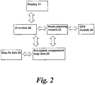
- FIG. 2 shows schematically the core software modules deployed in a navigation device implementing the invention.
- the display 21 is a touch screen display that the user enters a destination address into in the conventional manner. That address data input is handled by the UI module 22 and sent to the navigation/route planning module 23.
- Route planning module 23 taking a GPS feed from GPS module 24, plans a route using map data from the encrypted, compressed map data that the device was shipped with (or was otherwise supplied from the map vendor, such as Tele Atlas).
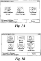
- the present invention is then implemented as follows: the user enters a map correction as and when needed, using a touch screen interaction, touching large graphical icons, as exemplified by Figures 1A and 1B , into display 21.
- the UI module 22 captures the map fix and sends it to a map fix store 26.
- the map fix As soon as the map fix is in the map fix 26 store, it is made available to the route planning module 22 and the UI module 22. If the map fix requires re-planning of even the current route being driven, then that will happen automatically (if the user configures that option). For example, the device might plan a route that requires the user to turn into a street: when the turning is approached, the user finds that it has recently been made a 'no entry' street. The user can enter an appropriate map correction: a new route, taking into account the no entry street, is then immediately planned and appropriate route guidance given. Likewise, if the user plans a completely new route to another destination, the new route will also take the map fix into account.
- map fix should affect how the map should appear (for example, re-naming a road, showing a new POI, such as a speed camera), then that new appearance will be immediately present. Automatic use of the correction is not mandatory though; some users may prefer for route calculation etc. to exclude map corrections.
- Appendix 1 describes a typical device that can implement the present invention.
- Appendix 2 are the high level requirements for Map Share.
- the present invention can be implemented in an integrated navigation device from TomTom B.V. called GO.
- GO deploys navigation software called Navigator (or Navcore) and has an internal GPS receiver; Navigator software can also run on a touch screen (i.e. stylus controlled) Pocket PC powered PDA device, such as the Compaq iPaq. It then provides a GPS based navigation system when the PDA is coupled with a GPS receiver.
- the combined PDA and GPS receiver system is designed to be used as an in-vehicle navigation system.
- the invention may also be implemented in any other arrangement of navigation device, such as one with an integral GPS receiver/computer/display, or a device designed for non-vehicle use (e.g. for walkers) or vehicles other than cars (e.g. aircraft).
- the navigation device may implement any kind of position sensing technology and is not limited to GPS; it can hence be implemented using other kinds of GNSS (global navigation satellite system) such as the European Galileo system. Equally, it is not limited to satellite based location/velocity systems but can be deployed using ground-based beacons or any other kind of system that enables the device to determine its geographic location.
- Navigator software when running on a PDA, results in a navigation device that causes the normal navigation mode screen shown in Figure 3 to be displayed.
- This view provides driving instructions using a combination of text, symbols, voice guidance and a moving map.
- Key user interface elements are the following: a 2-D map 1 occupies most of the screen. The map shows the user's car and its immediate surroundings, rotated in such a way that the direction in which the car is moving is always "up". Running across the bottom quarter of the screen is the status bar 2.
- the current location of the device, as the device itself determines using conventional GPS location finding and its orientation (as inferred from its direction of travel) is depicted by an arrow 3.
- the route calculated by the device (using route calculation algorithms stored in device memory as applied to map data stored in a map database in device memory) is shown as darkened path 4 superimposed with arrows giving the travel direction. On the darkened path 4, all major actions (e.g. turning corners, crossroads, roundabouts etc.) are schematically depicted by arrows 5 overlaying the path 4.
- the status bar 2 also includes at its left hand side a schematic 6 depicting the next action (here, a right turn).
- the status bar 2 also shows the distance to the next action (i.e. the right turn - here the distance is 220 meters) as extracted from a database of the entire route calculated by the device (i.e. a list of all roads and related actions defining the route to be taken).
- Status bar 2 also shows the name of the current road 8, the estimated time before arrival 9 (here 2 minutes and 40 seconds), the actual estimated arrival time 10 (11.36am) and the distance to the destination 11 (1.4Km).
- the GPS signal strength is shown in a mobile-phone style signal strength indicator 12.
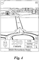
- a 3-D map view is also possible, as shown in Figure 4 .
- a navigation screen main menu (not shown) is displayed; from this menu, other core navigation functions within the Navigator application can be initiated or controlled. Allowing core navigation functions to be selected from a menu screen that is itself very readily called up (e.g. one step away from the map display to the menu screen) greatly simplifies the user interaction and makes it faster and easier.
- the area of the touch zone which needs to be touched by a user is far larger than in most stylus based touch screen systems. It is designed to be large enough to be reliably selected by a single finger without special accuracy; i.e. to mimic the real-life conditions for a driver when controlling a vehicle; he or she will have little time to look at a highly detailed screen with small control icons, and still less time to accurately press one of those small control icons.
- using a very large touch screen area associated with a given soft key (or hidden soft key, as in the centre of the screen 13) is a deliberate design feature of this implementation. Unlike other stylus based applications, this design feature is consistently deployed throughout Navigator to select core functions that are likely to be needed by a driver whilst actually driving.
- the device displays a map. Touching the map (i.e. the touch sensitive display) once (or twice in a different implementation) near to the screen centre (or any part of the screen in another implementation) will then call up either directly (i.e. the next level down) or indirectly (i.e.
- a navigation menu (see Figure 5 ) with large icons corresponding to various navigation functions, such as the option to calculate an alternative route, and recalculate the route so as to avoid the next section of road (useful when faced with an obstruction or heavy congestion); or recalculate the route so as to avoid specific, listed roads.
- memory stores the route calculation algorithms, map database and user interface software; a microprocessor interprets and processes user input (e.g. using a device touch screen to input the start and destination addresses and all other control inputs) and deploys the route calculation algorithms to calculate the optimal route.
- a microprocessor interprets and processes user input (e.g. using a device touch screen to input the start and destination addresses and all other control inputs) and deploys the route calculation algorithms to calculate the optimal route.
- 'Optimal' may refer to criteria such as shortest time or shortest distance, or some other user-related factors.
- the user inputs his start position and required destination in the normal manner into the Navigator software running on the PDA using a virtual keyboard.
- the user selects the manner in which a travel route is calculated: various modes are offered, such as a 'fast' mode that calculates the route very rapidly, but the route might not be the shortest; a 'full' mode that looks at all possible routes and locates the shortest, but takes longer to calculate etc.
- Other options are possible, with a user defining a route that is scenic - e.g. passes the most POI (points of interest) marked as views of outstanding beauty, or passes the most POIs of possible interest to children or uses the fewest junctions etc.
- Roads themselves are described in the map database that is part of Navigator (or is otherwise accessed by it) running on the PDA as lines - i.e. vectors (e.g. start point, end point, direction for a road, with an entire road being made up of many hundreds of such sections, each uniquely defined by start point/end point direction parameters).
- a map is then a set of such road vectors, plus points of interest (POIs), plus road names, plus other geographic features like park boundaries, river boundaries etc, all of which are defined in terms of vectors. All map features (e.g. road vectors, POIs etc.) are defined in a co-ordinate system that corresponds or relates to the GPS co-ordinate system, enabling a device's position as determined through a GPS system to be located onto the relevant road shown in a map.
- Route calculation uses complex algorithms that are part of the Navigator software.
- the algorithms are applied to score large numbers of potential different routes.
- the Navigator software then evaluates them against the user defined criteria (or device defaults), such as a full mode scan, with scenic route, past museums, and no speed camera.
- the route which best meets the defined criteria is then calculated by a processor in the PDA and then stored in a database in RAM as a sequence of vectors, road names and actions to be done at vector end-points (e.g. corresponding to pre-determined distances along each road of the route, such as after 100 meters, turn left into street x).
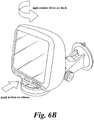
- FIGS. 6A and 6B are perspective views of an actual implementation of a navigation device.
- the navigation device is a unit that includes display, internal GPS receiver, microprocessor, power supply and memory systems.
- the device sites on an arm, which itself is secured to the car dashboard using a large suction cup.
- FIG. 7 schematically depicts the device.
- the device indicated generally at 51, includes conventional items such as a microprocessor 56, power source 57, display and related rivers 58.
- a SD card reader 53 In addition, it includes a SD card 52 is shown slotted into position.
- the device 51 has internal DRAM 54 and XIP Flash 55 and.
- the device hence uses three different forms of memory:
- the proprietary boot loader 55 will prompt for the user to insert the supplied SD card 52.
- the device will copy a special system file from the SD card 52 into RAM 54. This file will contain the Operating System and navigation application. Once this is complete control will be passed to the application.
- the application then starts and access non-volatile data e.g. maps from the SD card 52.
- GO is a stand-alone fully integrated personal navigation device. It will operate independently from any connection to the vehicle.
- GO is intended to address the general personal navigation market. In particular it is designed to extend the market for personal navigation beyond the "early adopter" market. As such it is a complete stand-alone solution; it does not require access to a PC, PDA or Internet connection. The emphasis will be on completeness and ease of use.
- GO is an in-vehicle personal navigation device. It is designed as an appliance, that is, for a specific function rather than a general purpose one. It is designed for the consumer after-sales automotive market. It will be simple to use and install by the end user, although a professional fitting kit will be optionally supplied.
- GO will use a customised version of embedded Linux. This will be loaded from an SD card by a custom boot-loader program which resides in Flash memory
- GO will have only one hard button, the power button. It is pressed once to turn on or off GO.
- the UI will be designed so that all other operations are easily accessible through the pen based UI.
- GO architecture is based around a highly integrated single chip processor designed for mobile computing devices. This device delivers approximately 200 MIPs of performance from an industry standard ARM920T processor. It also contains all the peripherals required excluding the GPS base-band. These peripherals include DRAM controller, timer/counters, UARTs, SD interface and LCD controller.
- the main elements of this architecture are:
- Figure 8 is the GO block diagram.
- GO will be powered from an integrated Li-Ion 2200 mAH rechargeable battery.
- This battery can be charged, and the device powered (even if the battery contains no charge) from an externally supplied +5V power source.
- This external +5V power source is supplied via the docking connector or a DC jack socket.
- This +5V supply will be generated from the vehicle's main supply rail or from a mains adapter externally.
- the device will be turned on and off by a single button. When the device is turned off the DRAM contents will be preserved by placing the RAM in self-refresh so that when switched on GO will resume from where it was switched off. There will also be a wake-up signal available through he docking connector, this can be used to auto-switch on GO when the vehicle ignition is switched on.
- a 52 mm diameter speaker is housed in GO to give good quality spoken instructions. This will be driven by an internal amplifier and audio codec. Audio line out will also be present on the docking connector.
- GO will contain one standard SD card socket. These are used to load system software and to access map data.
- GO will use a transflective 3.5" TFT backlit display It will be a 'standard' 1 ⁇ 4VGA display as used by PocketPC PDA's. It will also contain a touch panel and bright CCFL backlight.
- the product design should include Bluetooth although it is not populated in the standard variant to minimise BOM cost.
- the design should ensure that all other functions (including GPS RF performance) operate without degradation when the Bluetooth function is operating.
- the product design should ensure it is possible to fit 64Mbyte RAM instead of 32Mbyte.
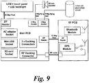
- GO consists of the following electrical subassemblies, shown in Figure 9 .
- the RF cable feeds the RF signal from an external GPS antenna (which connects to GO via the RF docking connector) to the RF PCB where the GPS module is situated.
- Two Docking Connectors provide an interface to external Docking Stations.
- Docking Connector #1 pinout Pin Signal Dir Type Description 1 GND - - Signal and power GND 2 GND - - 3 DOCKSNS1 I/P PU Docking Station Sense [0,1] - These signals are connected to pull-up resistors within the unit. The Docking Station pulls either or both of these signals to GND to indicate the presence and type of Docking Station.
- 4 DOCKSNSO I/P PU 5 AUDIOL O/P Audio line outputs (Left and Right) to connect to car audio system.
- the RF Docking Connector allows connection of an external active GPS antenna via a Docking Station.
- the AC adapter socket allows power to be supplied from a low cost AC adapter or CLA (Cigarette Lighter Adapter).
- CLA Cigarette Lighter Adapter
- the USB connector allows connection to a PC by means of a standard mini USB cable.
- a hard locking SD card socket suitable for high vibration applications supports SDIO, SD memory and MMC cards.
- the processor is the ARM920T based SOC (System on chip) operating at approx 200Mhz.
- Type SDRAM with low-power refresh (“mobile” SDRAM) Total memory 32 Mbyte (standard) or 64 Mbyte (future option) Bus width 32-bit Minimum speed 100Mhz Maximum self refresh current 500 ⁇ A per device Configuration 2 x 16-bit wide CSP sites
- GO will be fitted with a minimum of 256kbyte of 16-bit wide Flash Memory to contain the following:
- the GPS internal antenna is attached directly to the RF PCB.
- the GPS antenna source is automatically switched to the external antenna.
- a solid state accelerometer is connected directly to the processor to provide information about change of speed and direction.
- the IGNITION signal may be connected to a 12V or 24V vehicle battery.
- the state of the Docking Station IGNITION signal is detected and fed to a GPIO pin to allow software to turn off the unit when the ignition signal goes low.
- peripherals will be included as standard with GO.
- map errors can be corrected immediately by the user. This section describes the user requirements relating to map corrections.
- the user shall be able to make map corrections on their NavCore device.
- the user shall be able to make map corrections within the Navigator control of the TomTom Home application.
- This section describes the user requirements relating to the types of map correction that can be made.
- the user shall be able to add the locations of safety cameras on the map.
- the user shall be able to block roads on the map.
- the user shall be able to un-block roads on the map.
- the user shall be able to modify the traffic direction properties of roads on the map. Specifically the user shall be able to:
- the user shall be able to add a road (consisting of one or more nodes) on the map.
- the user shall be able to connect 2 points on the map and define this new link as a new road.
- the user shall be able to add street names to un-named roads on the map.
- the user shall be able to modify the names of roads on the map.
- the user shall be able to modify the maximum speed of roads on the map.
- map corrections are present on the NavCore device, they must be made available to the user. This section describes the user requirements relating to the availability of on-device corrections.
- the user shall be able to use private corrections as soon as they are recorded.
- the user shall be able to use public corrections as soon as they have been downloaded to the device.
- map corrections may have been made by other TomTom owners, the user must be able to select which corrections to use when calculating routes. This section describes the user requirements relating to the use of map corrections on the user's device.
- the user shall be able to choose whether to receive warnings for private and/or public reported safety cameras.
- the user shall be able to use or ignore their Private map corrections whenever they plan a route that includes a correction.
- the user shall be able to use or ignore their Public map corrections whenever they plan a route that includes a correction.
- the user shall be able to configure their device such that private and/or public corrections from one or more categories are automatically included within route calculations.
- the user shall be informed that they are using corrections.
- the user shall be able to recalculate routes to include or exclude map corrections.
- the user shall be able to remove a map correction from their device.
- map errors are too complicated or large in scale to make corrections on the device itself. These errors need to be reported to TomTom, so that we (or our map suppliers) can take corrective action. This section describes the user requirements relating to map error reporting.
- the user shall be able to create map error reports on their device and upload these to the TomTom PLUS server.
- the user shall be able to create map error reports within the Navigator control of the TomTom Home and upload these to the TomTom PLUS server.
- the user shall be able to import map error reports captured on their device to the TomTom Home application.
- the user shall be able to edit these reports and then upload them to the TomTom PLUS server.
- the user shall be given feedback regarding their map error reports.
- the user shall be prompted to block roads that they chose to avoid within route plans on multiple occasions.
- the user shall be prompted to add a road on the map if they drive through a map area that is not marked as a road on multiple occasions.
- the user shall be prompted to add a name to unnamed roads on the map if they plan routes to such a road on multiple occasions.
- the user shall be prompted to modify the speed limit of a road if they drive along it at a significantly different speed from that stated in the map data on multiple occasions.
- Map Share Users of Map Share may wish to share their corrections with other TomTom owners. This section describes the user requirements relating to the user's ability to share map corrections with other TomTom owners.
- the user shall be able to create corrections for their personal use only. These corrections shall NOT be sent to the TomTom PLUS server.
- the user shall be able to create corrections that are shared with other TomTom owners. These corrections shall be uploaded to the TomTom PLUS server and made available to other Map Share users.
- the user shall be able to categorise their public map corrections according to the user community for which it is applicable.
- the following community categories shall be made available:
- the user shall be able to acquire "trusted user” status, based upon the number and quality of map corrections that they upload.
- the user shall be informed if they attempt to report a map correction that has been corrected in a newer version of the map data that they are using.
- the user shall also be informed how they can purchase the updated map.
- the user shall be able to download public map corrections from the TomTom PLUS server to their device, and to the TomTom Home application.
- the user shall be able to download public map corrections from one or more community categories.
- the user shall be able to download public map corrections from one or more community source categories.
- Public correction source categories are defined in section 2.2.1.5.
- the user shall be able to download public map corrections from one or more map supplier source categories.
- a supplier category shall be provided for each TomTom map supplier.
- the user shall be able to download public map corrections from one or more location categories.
- Map Share Some features within Map Share must be implemented in a specific way in order to address the user's requirements and protect TomTom's interests. This section describes all known technical constraints placed upon the V1 scope of Map Share.
- Map Share In order to allow users to make informed decisions relating to public map corrections, Map Share must manage these corrections. This section describes the constraints relating to map correction categorisation.
- TomTom shall aggregate all public map corrections sent to the TomTom PLUS server.
- Public map corrections shall be analysed in order to assess their source, applicability and trustworthiness.
- TomTom shall distribute all public map corrections to Map Share users upon request.
- TomTom shall assess the applicability of each map correction with respect to each map supplied to users. If a map correction is found not to be applicable for a given map then it shall be removed from the aggregated map corrections and NOT distributed to users of this map.
- Map corrections held on the TomTom PLUS server shall be categorised by source so that the user can be informed of the relative trustworthiness of the correction's source.
- TomTom shall be able to endorse specific map corrections and these shall be represented to the user in a specific category.
- Map corrections that have been reported by a single user shall be represented to other users in a specific category.
- Map corrections that have been reported by more than one user shall be represented to other users in specific categories. Specifically, the following categories shall be represented:
- Map corrections that have been reported by trusted users shall be represented to other users in a specific category.
- Map Share users shall be able to endorse map corrections made by other TomTom owners and evidence of these endorsements shall be represented to the user.
- map correction data is held in a structured, re-usable and secure way. This section describes the constraints relating to security.
- Each map correction shall be uniquely identified.
- Each map correction captured on the device shall be time stamped with the time at which it was input and/or reported.
- Each map correction shall be stored in a form that allows it to be applied to the map independently of all other map corrections (i.e. NavCore shall be able to decide on a per-correction basis whether the correction should be applied to the map and represented to the user).
- Map corrections shall NOT make a permanent modification to the user's map data.
- Map corrections shall be highly compressible to allow fast and cheap distribution over wireless networks.
- Map corrections shall be highly encrypted such that it is not possible for the data format to be reverse engineered.
- Map corrections shall be stored in such a way that they are retained though a map upgrade process.
- Map corrections shall be compatible with future map versions, such that corrections made on older versions of a map can be applied to the latest version.
- Map corrections shall NOT be compatible with previous map versions. It shall NOT be possible to apply a map correction made on the current map version with a previous map version.
- Map corrections shall be independent of map suppler, such that map corrections can be applied to maps from different suppliers.
- Map corrections shall be stored in a format that is compatible with the Tele Atlas map reporting API such that TomTom is capable of sending correctly formatted reports to Tele Atlas if it wishes to do so.
- Map corrections created on previous map versions shall be checked to see if they are applicable to the currently loaded map on the user's device. Map corrections that are not applicable shall NOT be used within route calculations.
- map error reports shall be created in a format that is compatible with the Tele Atlas map error reporting API.
- TomTom shall aggregate all map error reports from user devices, TomTom Home and the TomTom website.
- TomTom shall assess all map error reports and assign priorities to these, such that the most serious errors are clearly highlighted. These priorities shall be communicated to TomTom map suppliers when submitting error reports to them.
- Map error reports shall be stored in a format that is compatible with the Tele Atlas map reporting API such that TomTom is capable of sending correctly formatted reports to Tele Atlas if it wishes to do so.
- the user shall be able to modify the names of cities (and other places) on the map.
- the user shall be able to block access to a road for one or more transportation types. Specifically the user shall be able to block access for the following transportation types:
- the user shall be able to un-block access to a road for one or more transportation types. Specifically the user shall be able to un-block access for the following transportation types:
- the user shall be able to modify the "class" of roads on the map.
- road classes are used to define the properties of roads and are used within route calculation.
- the user shall be able to add turn restrictions to roads on the map.
- the user shall be able to remove turn restrictions applied to roads on the map.
- the user shall be able to add house numbers (either a single number or a range) to roads on the map.
- the user shall be able to modify the location of house numbers (either a single number or a range) applied to roads on the map.
- the user shall be able to modify the average speed of roads on the map.
- the user shall be able to mark a road on the map as a toll road.
- the user shall be able to remove the presence of a toll from roads on the map.
- the user shall be able to add signpost information to roads on the map.
- the user shall be able to modify the properties of signpost information associated with roads on the map.
- the user shall be able to remove signpost information associated with roads on the map.
- the user shall be able to modify the location of POI on the map.
- the user shall be able to modify the names of POI on the map.
- the user shall be able to modify the category of POI on the map.
- the user shall be able to remove POI from the map.
- the user shall be able to modify the exit numbers of motorways on the map.
- the user shall be able to modify the post code associated with a road on the map.
- the user shall be able to add road height restrictions to roads on the map.
- the user shall be able to add road width restrictions to roads on the map.
- the user shall be able to add road weight restrictions to roads on the map.
- map errors are too complicated or large in scale to make corrections on the device itself. These errors need to be reported to TomTom, so that we (or our map suppliers) can take corrective action. This section describes the user requirements relating to map error reporting.
- the user shall be able to create map error reports within TomTom Support Website and upload these to the TomTom PLUS server.
- Map Share Some features within Map Share must be implemented in a specific way in order to address the user's requirements and protect TomTom's interests. This section describes all known technical constraints that have been omitted from the V1 scope of Map Share.
- TomTom shall implement the Tele Atlas map error reporting API and use this as the reporting mechanism for all reports to Tele Atlas.
Landscapes
- Engineering & Computer Science (AREA)
- Radar, Positioning & Navigation (AREA)
- Remote Sensing (AREA)
- Physics & Mathematics (AREA)
- General Physics & Mathematics (AREA)
- Automation & Control Theory (AREA)
- Business, Economics & Management (AREA)
- Marketing (AREA)
- General Business, Economics & Management (AREA)
- Economics (AREA)
- General Health & Medical Sciences (AREA)
- Human Resources & Organizations (AREA)
- Computing Systems (AREA)
- Primary Health Care (AREA)
- Strategic Management (AREA)
- Tourism & Hospitality (AREA)
- Health & Medical Sciences (AREA)
- Theoretical Computer Science (AREA)
- Navigation (AREA)
- Instructional Devices (AREA)
- Traffic Control Systems (AREA)
- Information Retrieval, Db Structures And Fs Structures Therefor (AREA)
- Management, Administration, Business Operations System, And Electronic Commerce (AREA)
- Information Transfer Between Computers (AREA)
Claims (11)
- Un procédé de mise à jour d'une carte numérique utilisant les données cartographiques rectifiées, incluant les étapes de :réception des données cartographiques rectifiées sur un serveur à partir de différents dispositifs de navigation ;validation desdites données cartographiques rectifiées ;classement desdites données cartographiques rectifiées dans au moins une catégorie ; etstockage desdites données cartographiques rectifiées, qui ont été validées et classées sur le serveur, ainsi que l'utilisation des données cartographiques rectifiées et stockées afin de mettre à jour une carte numérique, où au moins une desdites étapes de validation et classement se fonde sur au moins la source des données cartographiques rectifiées et reçues.
- Le procédé selon la revendication 1, où ladite étape de réception inclut également l'étape de réception desdites données cartographiques rectifiées à partir d'une connexion sans fil pour le transfert des données.
- Le procédé selon les revendications 1 ou 2, où ladite étape de réception inclut également l'étape de réception desdites données cartographiques rectifiées sur Internet.
- Le procédé selon les revendications précédentes, où l'étape de validation inclut également au moins une des étapes de recherche de termes malveillants, pour vérifier les corrections doubles et divergentes.
- Le procédé selon les revendications précédentes, où au moins une catégorie inclut au moins un classement par communauté, un classement par correction, un classement par source, un classement par localisation, un classement par langue, un classement par validité, un classement par importance, un classement par catégorie des points d'intérêt/information, un classement par priorité et un classement cartographique par fournisseur.
- Un serveur pour mettre à jour une carte numérique utilisant les données cartographiques rectifiées, incluant les moyens de :réception des données cartographiques rectifiées à partir de différents dispositifs de navigation ;validation desdites données cartographiques rectifiées ;classement desdites données cartographiques rectifiées dans au moins une catégorie ; etstockage desdites données cartographiques rectifiées, qui ont été validées et classées, ainsi que l'utilisation des données cartographiques rectifiées et stockées afin de mettre à jour une carte numérique, où au moins un desdits moyens de validation et classement se fonde sur au moins la source des données cartographiques rectifiées et reçues.
- Le serveur selon la revendication 6, où lesdits moyens de réception desdites données cartographiques rectifiées incluent les moyens de réception desdites données cartographiques rectifiées à partir d'une connexion sans fil pour le transfert des données.
- Le serveur selon les revendications 6 ou 7, où lesdits moyens de réception desdites données cartographiques rectifiées incluent les moyens de réception desdites données cartographiques rectifiées sur Internet.
- Le serveur selon les revendications 6 à 8, où lesdits moyens de validation des données cartographiques rectifiées incluent les moyens de réception desdites données cartographiques rectifiées par le biais d'au moins une des étapes de recherche de termes malveillants, pour vérifier les corrections doubles et divergentes.
- Le serveur selon les revendications 6 à 9, où au moins une catégorie inclut au moins un classement par communauté, un classement par correction, un classement par source, un classement par localisation, un classement par langue, un classement par validité, un classement par importance, un classement par catégorie des points d'intérêt/information, un classement par priorité et un classement cartographique par fournisseur.
- Logiciel qui, lors de son exécution sur un dispositif serveur, entraîne le dispositif serveur à exécuter le procédé de l'une des revendications 1 à 5.
Applications Claiming Priority (3)
| Application Number | Priority Date | Filing Date | Title |
|---|---|---|---|
| GB0616211A GB2440958A (en) | 2006-08-15 | 2006-08-15 | Method of correcting map data for use in navigation systems |
| US90130907P | 2007-02-15 | 2007-02-15 | |
| PCT/EP2007/007308 WO2008019882A1 (fr) | 2006-08-15 | 2007-08-15 | Procédé et appareil permettant d'organiser des données de correction de carte |
Publications (2)
| Publication Number | Publication Date |
|---|---|
| EP2069720A1 EP2069720A1 (fr) | 2009-06-17 |
| EP2069720B1 true EP2069720B1 (fr) | 2017-01-18 |
Family
ID=37081024
Family Applications (8)
| Application Number | Title | Priority Date | Filing Date |
|---|---|---|---|
| EP07801746A Withdrawn EP2052207A1 (fr) | 2006-08-15 | 2007-08-15 | Procédé de création de données de carte améliorées destinées à un usage dans des dispositifs de navigation |
| EP07801749.8A Active EP2052210B1 (fr) | 2006-08-15 | 2007-08-15 | Procédé et système permettant de distribuer des données de correction de carte classées par catégories |
| EP07801747.2A Active EP2052214B1 (fr) | 2006-08-15 | 2007-08-15 | Procédé de création de données de carte améliorées destinées à un usage dans des dispositifs de navigation |
| EP07801750A Withdrawn EP2052211A1 (fr) | 2006-08-15 | 2007-08-15 | Procédé de création de données de carte améliorées destinées à un usage dans des dispositifs de navigation et dispositif de navigation comprenant des données de carte améliorées |
| EP07801748.0A Active EP2069720B1 (fr) | 2006-08-15 | 2007-08-15 | Procédé et appareil permettant d'organiser des données de correction de carte |
| EP11155632.0A Active EP2327961B1 (fr) | 2006-08-15 | 2007-08-15 | Procédé de génération d'une carte améliorée pour une utilisation dans des dispositifs de navigation |
| EP07801745.6A Active EP2052209B1 (fr) | 2006-08-15 | 2007-08-15 | Procédé de création de données de carte améliorées destinées à un usage dans des dispositifs de navigation et dispositif de navigation associé |
| EP07801751A Withdrawn EP2052212A1 (fr) | 2006-08-15 | 2007-08-15 | Procédé de création de données de carte destinées à un usage dans des dispositifs de navigation |
Family Applications Before (4)
| Application Number | Title | Priority Date | Filing Date |
|---|---|---|---|
| EP07801746A Withdrawn EP2052207A1 (fr) | 2006-08-15 | 2007-08-15 | Procédé de création de données de carte améliorées destinées à un usage dans des dispositifs de navigation |
| EP07801749.8A Active EP2052210B1 (fr) | 2006-08-15 | 2007-08-15 | Procédé et système permettant de distribuer des données de correction de carte classées par catégories |
| EP07801747.2A Active EP2052214B1 (fr) | 2006-08-15 | 2007-08-15 | Procédé de création de données de carte améliorées destinées à un usage dans des dispositifs de navigation |
| EP07801750A Withdrawn EP2052211A1 (fr) | 2006-08-15 | 2007-08-15 | Procédé de création de données de carte améliorées destinées à un usage dans des dispositifs de navigation et dispositif de navigation comprenant des données de carte améliorées |
Family Applications After (3)
| Application Number | Title | Priority Date | Filing Date |
|---|---|---|---|
| EP11155632.0A Active EP2327961B1 (fr) | 2006-08-15 | 2007-08-15 | Procédé de génération d'une carte améliorée pour une utilisation dans des dispositifs de navigation |
| EP07801745.6A Active EP2052209B1 (fr) | 2006-08-15 | 2007-08-15 | Procédé de création de données de carte améliorées destinées à un usage dans des dispositifs de navigation et dispositif de navigation associé |
| EP07801751A Withdrawn EP2052212A1 (fr) | 2006-08-15 | 2007-08-15 | Procédé de création de données de carte destinées à un usage dans des dispositifs de navigation |
Country Status (10)
| Country | Link |
|---|---|
| US (8) | US20100131189A1 (fr) |
| EP (8) | EP2052207A1 (fr) |
| JP (10) | JP2010500586A (fr) |
| KR (7) | KR20090040467A (fr) |
| CN (9) | CN101517367B (fr) |
| AU (7) | AU2007286433A1 (fr) |
| GB (1) | GB2440958A (fr) |
| RU (7) | RU2482540C2 (fr) |
| TW (7) | TW200829875A (fr) |
| WO (7) | WO2008019885A1 (fr) |
Families Citing this family (259)
| Publication number | Priority date | Publication date | Assignee | Title |
|---|---|---|---|---|
| USRE47986E1 (en) | 2003-05-15 | 2020-05-12 | Speedgauge, Inc. | System and method for evaluating vehicle and operator performance |
| US20040243307A1 (en) * | 2003-06-02 | 2004-12-02 | Pieter Geelen | Personal GPS navigation device |
| JP4669331B2 (ja) * | 2005-06-24 | 2011-04-13 | アルパイン株式会社 | 車両用走行誘導装置及び車両用走行誘導装置の更新地図データ生成方法 |
| US7634354B2 (en) * | 2005-08-31 | 2009-12-15 | Microsoft Corporation | Location signposting and orientation |
| US20070239353A1 (en) * | 2006-03-03 | 2007-10-11 | David Vismans | Communication device for updating current navigation contents |
| US8532678B2 (en) * | 2006-03-08 | 2013-09-10 | Tomtom International B.V. | Portable GPS navigation device |
| US20080294690A1 (en) * | 2007-05-22 | 2008-11-27 | Mcclellan Scott | System and Method for Automatically Registering a Vehicle Monitoring Device |
| US8630768B2 (en) | 2006-05-22 | 2014-01-14 | Inthinc Technology Solutions, Inc. | System and method for monitoring vehicle parameters and driver behavior |
| US9067565B2 (en) * | 2006-05-22 | 2015-06-30 | Inthinc Technology Solutions, Inc. | System and method for evaluating driver behavior |
| CN101467003A (zh) * | 2006-06-30 | 2009-06-24 | 电子地图北美公司 | 用于收集关于地理数据的用户更新请求以支持自动化分析、处理和地理数据更新的方法和系统 |
| GB2440958A (en) * | 2006-08-15 | 2008-02-20 | Tomtom Bv | Method of correcting map data for use in navigation systems |
| US8180558B1 (en) | 2007-04-04 | 2012-05-15 | Xm Satellite Radio Inc. | System and method for improved traffic flow reporting using satellite digital audio radio service (SDARS) and vehicle communications, navigation and tracking system |
| US9129460B2 (en) | 2007-06-25 | 2015-09-08 | Inthinc Technology Solutions, Inc. | System and method for monitoring and improving driver behavior |
| US8818618B2 (en) * | 2007-07-17 | 2014-08-26 | Inthinc Technology Solutions, Inc. | System and method for providing a user interface for vehicle monitoring system users and insurers |
| US9117246B2 (en) | 2007-07-17 | 2015-08-25 | Inthinc Technology Solutions, Inc. | System and method for providing a user interface for vehicle mentoring system users and insurers |
| US8095248B2 (en) | 2007-09-04 | 2012-01-10 | Modular Mining Systems, Inc. | Method and system for GPS based navigation and hazard avoidance in a mining environment |
| US7876205B2 (en) | 2007-10-02 | 2011-01-25 | Inthinc Technology Solutions, Inc. | System and method for detecting use of a wireless device in a moving vehicle |
| US8521430B2 (en) * | 2007-12-28 | 2013-08-27 | Navteq B.V. | Managing differences between geographic database versions |
| US20090177987A1 (en) * | 2008-01-04 | 2009-07-09 | Prasantha Jayakody | Efficient display of objects of interest to a user through a graphical user interface |
| US20090177378A1 (en) * | 2008-01-07 | 2009-07-09 | Theo Kamalski | Navigation device and method |
| US20090216442A1 (en) * | 2008-02-26 | 2009-08-27 | Nokia Corporation | Method, apparatus and computer program product for map feature detection |
| US9495386B2 (en) | 2008-03-05 | 2016-11-15 | Ebay Inc. | Identification of items depicted in images |
| EP2250623A4 (fr) | 2008-03-05 | 2011-03-23 | Ebay Inc | Procédé et appareil de services de reconnaissance d'images |
| CN101946157A (zh) * | 2008-03-14 | 2011-01-12 | 通腾科技股份有限公司 | 改进的导航装置及方法 |
| DE102009017731A1 (de) * | 2008-04-30 | 2009-11-05 | Continental Teves Ag & Co. Ohg | Selbstlernende Karte auf Basis von Umfeldsensoren |
| CN102007377A (zh) | 2008-05-02 | 2011-04-06 | 通腾科技股份有限公司 | 用于强调地图路线的导航装置及方法 |
| US8856671B2 (en) * | 2008-05-11 | 2014-10-07 | Navteq B.V. | Route selection by drag and drop |
| US7483786B1 (en) | 2008-05-15 | 2009-01-27 | International Business Machines Corporation | Method and system for selective route search on satellite navigators |
| FR2931230A1 (fr) * | 2008-05-19 | 2009-11-20 | Peugeot Citroen Automobiles Sa | Procede de mise a jour automatique de donnees d'etat associees a des donnees cartographiques, pour un vehicule automobile, et dispositif associe |
| BRPI0822712A2 (pt) * | 2008-05-29 | 2015-07-07 | Tomtom Internac B V | Geração de uma imagem de exibição |
| US8775073B2 (en) | 2008-05-30 | 2014-07-08 | Navteq B.V. | Data mining in a digital map database to identify insufficient merge lanes along roads and enabling precautionary actions in a vehicle |
| US8688369B2 (en) * | 2008-05-30 | 2014-04-01 | Navteq B.V. | Data mining in a digital map database to identify blind intersections along roads and enabling precautionary actions in a vehicle |
| US9121716B2 (en) | 2008-05-30 | 2015-09-01 | Here Global B.V. | Data mining in a digital map database to identify insufficient superelevation along roads and enabling precautionary actions in a vehicle |
| US20090296990A1 (en) * | 2008-05-30 | 2009-12-03 | United Parcel Service Of America, Inc. | Evaluating driver walk distances and building types using overhead imagery |
| US9134133B2 (en) | 2008-05-30 | 2015-09-15 | Here Global B.V. | Data mining to identify locations of potentially hazardous conditions for vehicle operation and use thereof |
| US9182241B2 (en) | 2008-05-30 | 2015-11-10 | Here Global B.V. | Data mining in a digital map database to identify unusually narrow lanes or roads and enabling precautionary actions in a vehicle |
| US10648817B2 (en) | 2008-05-30 | 2020-05-12 | Here Global B.V. | Data mining in a digital map database to identify speed changes on upcoming curves along roads and enabling precautionary actions in a vehicle |
| US8698649B2 (en) | 2008-05-30 | 2014-04-15 | Navteq B.V. | Data mining in a digital map database to identify decreasing radius of curvature along roads and enabling precautionary actions in a vehicle |
| US8466810B2 (en) | 2008-05-30 | 2013-06-18 | Navteq B.V. | Data mining in a digital map database to identify intersections located at hill bottoms and enabling precautionary actions in a vehicle |
| TW200949211A (en) * | 2008-06-04 | 2009-12-01 | Tomtom Int Bv | Method and apparatus for preparing map data |
| US8700301B2 (en) | 2008-06-19 | 2014-04-15 | Microsoft Corporation | Mobile computing devices, architecture and user interfaces based on dynamic direction information |
| US9200901B2 (en) | 2008-06-19 | 2015-12-01 | Microsoft Technology Licensing, Llc | Predictive services for devices supporting dynamic direction information |
| US8467991B2 (en) * | 2008-06-20 | 2013-06-18 | Microsoft Corporation | Data services based on gesture and location information of device |
| US20090315775A1 (en) * | 2008-06-20 | 2009-12-24 | Microsoft Corporation | Mobile computing services based on devices with dynamic direction information |
| US20090319166A1 (en) * | 2008-06-20 | 2009-12-24 | Microsoft Corporation | Mobile computing services based on devices with dynamic direction information |
| KR20110026433A (ko) | 2008-06-25 | 2011-03-15 | 톰톰 인터내셔날 비.브이. | 주차시설 찾기를 탐지하는 내비게이션 장치 및 방법 |
| TWI374255B (en) | 2008-07-24 | 2012-10-11 | Htc Corp | Method and system for synchronizing mark on electronic map and computer program product using the same |
| EP2154482A1 (fr) * | 2008-07-31 | 2010-02-17 | Samsung Electronics Co., Ltd. | Système de navigation, procédé et base de données utilisant des dispositifs mobiles |
| DE102008045994A1 (de) * | 2008-09-05 | 2010-03-11 | Volkswagen Ag | Verfahren und Vorrichtung zum Anzeigen von Informationen in einem Fahrzeug |
| US8416067B2 (en) | 2008-09-09 | 2013-04-09 | United Parcel Service Of America, Inc. | Systems and methods for utilizing telematics data to improve fleet management operations |
| US11482058B2 (en) | 2008-09-09 | 2022-10-25 | United Parcel Service Of America, Inc. | Systems and methods for utilizing telematics data to improve fleet management operations |
| CN104764456B (zh) * | 2008-10-07 | 2018-02-16 | 通腾科技股份有限公司 | 验证地图数据校正 |
| AU2008362574A1 (en) * | 2008-10-07 | 2010-04-15 | Tomtom International B.V. | Validating map data corrections |
| DE102009045761B4 (de) | 2008-10-21 | 2022-12-22 | Continental Automotive Technologies GmbH | Verfahren zur Aktualisierung einer in einer digitalen Karte enthaltenen Geschwindigkeitsbegrenzung |
| DE102008053150B4 (de) | 2008-10-24 | 2022-06-09 | Rohde & Schwarz GmbH & Co. Kommanditgesellschaft | Verfahren zur Ermittlung von Information zu einer Wegkarte |
| US8219316B2 (en) * | 2008-11-14 | 2012-07-10 | Google Inc. | System and method for storing and providing routes |
| US8538688B2 (en) | 2008-11-18 | 2013-09-17 | Nokia Corporation | User generated pedestrian and indoor shortcut routes for navigation systems |
| US20100125406A1 (en) * | 2008-11-19 | 2010-05-20 | Nokia Corporation | Methods, apparatuses, and computer program products for providing point of interest navigation services |
| CN102272552A (zh) * | 2008-12-31 | 2011-12-07 | 电子地图北美公司 | 用于处理与地理区域相关的信息的系统及方法 |
| US9250331B2 (en) * | 2008-12-31 | 2016-02-02 | At&T Intellectual Property I, L.P. | Method and apparatus for providing mapping data |
| WO2010081544A1 (fr) * | 2009-01-14 | 2010-07-22 | Tomtom International B.V. | Système et procédé de cartographie |
| US8890715B2 (en) | 2009-01-14 | 2014-11-18 | Tomtom International B.V. | Navigation apparatus, server apparatus and method of collecting parking location information |
| EP2406583B1 (fr) * | 2009-01-14 | 2017-03-15 | Tomtom Traffic B.V. | Appareil pour valoriser la représentation d'un emplacement de stationnement et procédé de valorisation de la représentation d'un emplacement de stationnement |
| KR101011984B1 (ko) | 2009-02-06 | 2011-01-31 | 팅크웨어(주) | 3차원 모델 데이터 편집 장치 및 방법 |
| US8963702B2 (en) | 2009-02-13 | 2015-02-24 | Inthinc Technology Solutions, Inc. | System and method for viewing and correcting data in a street mapping database |
| US9075938B2 (en) * | 2009-02-27 | 2015-07-07 | Sri International | Method and apparatus for mapping of multiple-floor structures |
| US20100228612A1 (en) * | 2009-03-09 | 2010-09-09 | Microsoft Corporation | Device transaction model and services based on directional information of device |
| US20120047087A1 (en) | 2009-03-25 | 2012-02-23 | Waldeck Technology Llc | Smart encounters |
| US8756006B2 (en) * | 2009-03-26 | 2014-06-17 | Toyota Mapmaster Incorporated | Device and method for generating route restriction information of intersection, computer program for generating route restriction information of intersection, and recording medium for recording computer program |
| US9020745B2 (en) * | 2009-03-30 | 2015-04-28 | Microsoft Technology Licensing, Llc | Business data display and position correction in street-side imagery |
| TWI395928B (zh) * | 2009-05-20 | 2013-05-11 | Mitac Int Corp | 人工智慧規劃導航路線之方法 |
| US20100332324A1 (en) * | 2009-06-25 | 2010-12-30 | Microsoft Corporation | Portal services based on interactions with points of interest discovered via directional device information |
| US20100333040A1 (en) * | 2009-06-30 | 2010-12-30 | Honeywell International Inc. | Aircraft special notice display system and method |
| CN101944030A (zh) * | 2009-07-07 | 2011-01-12 | 英业达股份有限公司 | 开机方法 |
| US8872767B2 (en) | 2009-07-07 | 2014-10-28 | Microsoft Corporation | System and method for converting gestures into digital graffiti |
| EP2746727B1 (fr) | 2009-07-09 | 2016-09-07 | TomTom International B.V. | Procédé et dispositif pour le calcul de route avec dépendance temporelle |
| US8335990B2 (en) * | 2009-08-18 | 2012-12-18 | Nokia Corporation | Method and apparatus for grouping points-of-interest on a map |
| US9154560B2 (en) | 2009-10-12 | 2015-10-06 | Qualcomm Incorporated | Method and system for building annotation layers based on location aware user context information |
| US8306729B2 (en) * | 2009-10-13 | 2012-11-06 | Telenav, Inc. | Navigation system with user generated content mechanism and method of operation thereof |
| JP5409252B2 (ja) * | 2009-10-21 | 2014-02-05 | トヨタ自動車株式会社 | 車載機、情報提供装置、及びシステム並びに方法 |
| US9164577B2 (en) | 2009-12-22 | 2015-10-20 | Ebay Inc. | Augmented reality system, method, and apparatus for displaying an item image in a contextual environment |
| WO2011098195A1 (fr) * | 2010-02-15 | 2011-08-18 | Tomtom International B.V. | Procédés et systèmes d'obtention d'informations d'emplacement de charge |
| JP5471626B2 (ja) * | 2010-03-09 | 2014-04-16 | ソニー株式会社 | 情報処理装置、マップ更新方法、プログラム及び情報処理システム |
| DE102010003255A1 (de) * | 2010-03-25 | 2011-09-29 | Bayerische Motoren Werke Aktiengesellschaft | Verarbeitung von Korrekturdaten in einem Fahrzeug |
| US8812585B2 (en) * | 2010-03-29 | 2014-08-19 | Google Inc. | Trusted maps: updating map locations using trust-based social graphs |
| JP2011215206A (ja) * | 2010-03-31 | 2011-10-27 | Fujitsu Ten Ltd | 表示装置、及び、表示方法 |
| CN102947676B (zh) * | 2010-04-23 | 2016-06-01 | 通腾科技股份有限公司 | 导航装置及在其上实行的方法 |
| US8315799B2 (en) * | 2010-05-11 | 2012-11-20 | International Business Machines Corporation | Location based full address entry via speech recognition |
| US20110282573A1 (en) * | 2010-05-12 | 2011-11-17 | Globalsat Technology Corporation | Route planning method |
| US10066948B2 (en) | 2010-06-04 | 2018-09-04 | Nokia Technologies Oy | Method and apparatus for generating map-based snippets |
| US20110313779A1 (en) * | 2010-06-17 | 2011-12-22 | Microsoft Corporation | Augmentation and correction of location based data through user feedback |
| WO2011160731A1 (fr) * | 2010-06-23 | 2011-12-29 | Tomtom International B.V. | Processus de création de carte électronique |
| US8650193B1 (en) * | 2010-07-23 | 2014-02-11 | Google Inc. | Road splitting in a map editor |
| US8849867B1 (en) * | 2010-07-23 | 2014-09-30 | Google Inc. | Intersection clustering in a map editor |
| US9140573B2 (en) * | 2010-07-23 | 2015-09-22 | Google Inc. | Path finding in a map editor |
| CN102346259A (zh) * | 2010-08-02 | 2012-02-08 | 奚伟祖 | 基于gps全球定位系统的lbs位置相关服务定位误差自适应校准方法 |
| US8754777B1 (en) | 2010-08-13 | 2014-06-17 | Google Inc. | System and method for predicting user route and destination |
| US8849552B2 (en) | 2010-09-29 | 2014-09-30 | Ford Global Technologies, Llc | Advanced map information delivery, processing and updating |
| US10127606B2 (en) | 2010-10-13 | 2018-11-13 | Ebay Inc. | Augmented reality system and method for visualizing an item |
| US8571722B2 (en) * | 2010-10-22 | 2013-10-29 | Toyota Motor Engineering & Manufacturing North America, Inc. | Method for safely parking vehicle near obstacles |
| US8723888B2 (en) | 2010-10-29 | 2014-05-13 | Core Wireless Licensing, S.a.r.l. | Method and apparatus for determining location offset information |
| KR20120087225A (ko) * | 2010-11-29 | 2012-08-07 | 한국전자통신연구원 | 솔리드 압축을 이용한 타일 맵 서비스 방법 및 이를 위한 시스템 |
| EP2646781B1 (fr) * | 2010-11-30 | 2018-12-26 | TomTom Navigation B.V. | Procédés et systèmes de navigation |
| US20120188698A1 (en) * | 2011-01-21 | 2012-07-26 | E-Lead Electronic Co., Ltd. | Car audio system with changeable plug-in computer |
| US9146126B2 (en) * | 2011-01-27 | 2015-09-29 | Here Global B.V. | Interactive geographic feature |
| CN102170427A (zh) * | 2011-03-09 | 2011-08-31 | 深圳市凯立德科技股份有限公司 | 一种位置报错方法、位置服务终端及服务器 |
| US11763212B2 (en) | 2011-03-14 | 2023-09-19 | Amgine Technologies (Us), Inc. | Artificially intelligent computing engine for travel itinerary resolutions |
| CA2830224C (fr) | 2011-03-14 | 2017-12-05 | Amgine Technologies Limited | Procedes et systemes pour effectuer des transactions sur des biens et services lies aux voyages |
| US9659099B2 (en) | 2011-03-14 | 2017-05-23 | Amgine Technologies (Us), Inc. | Translation of user requests into itinerary solutions |
| US9070100B2 (en) | 2011-03-31 | 2015-06-30 | United Parcel Service Of America, Inc. | Calculating speed and travel times with travel delays |
| US9953468B2 (en) | 2011-03-31 | 2018-04-24 | United Parcel Service Of America, Inc. | Segmenting operational data |
| US9117190B2 (en) | 2011-03-31 | 2015-08-25 | United Parcel Service Of America, Inc. | Calculating speed and travel times with travel delays |
| US9208626B2 (en) | 2011-03-31 | 2015-12-08 | United Parcel Service Of America, Inc. | Systems and methods for segmenting operational data |
| EP2511662B1 (fr) * | 2011-04-11 | 2014-06-11 | Harman Becker Automotive Systems GmbH | Procédé pour guider un utilisateur d'un dispositif de navigation |
| DE102011007267A1 (de) * | 2011-04-13 | 2012-10-18 | Robert Bosch Gmbh | Verfahren zum Betreiben eines Navigationssystems eines Fahrzeugs und Navigationssystem |
| TWI425442B (zh) * | 2011-04-14 | 2014-02-01 | Univ Nat Central | Method of Reconstructing Three - dimensional Housing Model on Aeronautical Mapping System |
| JP5845616B2 (ja) * | 2011-04-20 | 2016-01-20 | 日産自動車株式会社 | 運転支援装置及び運転支援方法 |
| US8620032B2 (en) * | 2011-05-10 | 2013-12-31 | GM Global Technology Operations LLC | System and method for traffic signal detection |
| CN102222445A (zh) * | 2011-05-18 | 2011-10-19 | 深圳市凯立德科技股份有限公司 | 一种地图数据的更新方法、装置及位置服务终端 |
| US20120299962A1 (en) * | 2011-05-27 | 2012-11-29 | Nokia Corporation | Method and apparatus for collaborative augmented reality displays |
| US8683008B1 (en) | 2011-08-04 | 2014-03-25 | Google Inc. | Management of pre-fetched mapping data incorporating user-specified locations |
| ITTO20110850A1 (it) * | 2011-09-23 | 2013-03-24 | Sisvel Technology Srl | Metodo per gestire una mappa di un dispositivo di navigazione personale e relativo dispositivo |
| US8204966B1 (en) | 2011-09-26 | 2012-06-19 | Google Inc. | Map tile data pre-fetching based on user activity analysis |
| US8280414B1 (en) | 2011-09-26 | 2012-10-02 | Google Inc. | Map tile data pre-fetching based on mobile device generated event analysis |
| US9449342B2 (en) | 2011-10-27 | 2016-09-20 | Ebay Inc. | System and method for visualization of items in an environment using augmented reality |
| US9257056B2 (en) | 2011-10-31 | 2016-02-09 | Google Inc. | Proactive user-based content correction and enrichment for geo data |
| US9275374B1 (en) | 2011-11-15 | 2016-03-01 | Google Inc. | Method and apparatus for pre-fetching place page data based upon analysis of user activities |
| US8676506B1 (en) | 2011-11-15 | 2014-03-18 | Google Inc. | Systems and methods for identifying missing signage |
| US9063951B1 (en) | 2011-11-16 | 2015-06-23 | Google Inc. | Pre-fetching map data based on a tile budget |
| US8711181B1 (en) | 2011-11-16 | 2014-04-29 | Google Inc. | Pre-fetching map data using variable map tile radius |
| US8886715B1 (en) | 2011-11-16 | 2014-11-11 | Google Inc. | Dynamically determining a tile budget when pre-fetching data in a client device |
| US9305107B2 (en) | 2011-12-08 | 2016-04-05 | Google Inc. | Method and apparatus for pre-fetching place page data for subsequent display on a mobile computing device |
| US9197713B2 (en) | 2011-12-09 | 2015-11-24 | Google Inc. | Method and apparatus for pre-fetching remote resources for subsequent display on a mobile computing device |
| US9389088B2 (en) | 2011-12-12 | 2016-07-12 | Google Inc. | Method of pre-fetching map data for rendering and offline routing |
| US8803920B2 (en) | 2011-12-12 | 2014-08-12 | Google Inc. | Pre-fetching map tile data along a route |
| US8660735B2 (en) * | 2011-12-14 | 2014-02-25 | General Motors Llc | Method of providing information to a vehicle |
| CN102564435A (zh) * | 2012-01-06 | 2012-07-11 | 天津师范大学 | 一种导航电子地图的增量包及自校验方法 |
| WO2014172380A1 (fr) * | 2013-04-15 | 2014-10-23 | Flextronics Ap, Llc | Modification de comportement par l'intermédiaire de trajets de carte modifiés sur la base d'informations de profil d'utilisateur |
| US9332387B2 (en) | 2012-05-02 | 2016-05-03 | Google Inc. | Prefetching and caching map data based on mobile network coverage |
| US9031779B2 (en) * | 2012-05-30 | 2015-05-12 | Toyota Motor Engineering & Manufacturing North America, Inc. | System and method for hazard detection and sharing |
| US9152295B2 (en) * | 2012-06-05 | 2015-10-06 | Apple Inc. | Triage tool for problem reporting in maps |
| USD730364S1 (en) | 2012-06-05 | 2015-05-26 | Apple Inc. | Display screen or portion thereof with a graphical user interface |
| US9482296B2 (en) | 2012-06-05 | 2016-11-01 | Apple Inc. | Rendering road signs during navigation |
| US9418672B2 (en) | 2012-06-05 | 2016-08-16 | Apple Inc. | Navigation application with adaptive instruction text |
| US9230556B2 (en) | 2012-06-05 | 2016-01-05 | Apple Inc. | Voice instructions during navigation |
| US20130321400A1 (en) | 2012-06-05 | 2013-12-05 | Apple Inc. | 3D Map Views for 3D Maps |
| US9052197B2 (en) | 2012-06-05 | 2015-06-09 | Apple Inc. | Providing navigation instructions while device is in locked mode |
| US9997069B2 (en) | 2012-06-05 | 2018-06-12 | Apple Inc. | Context-aware voice guidance |
| US9886794B2 (en) | 2012-06-05 | 2018-02-06 | Apple Inc. | Problem reporting in maps |
| US10176633B2 (en) | 2012-06-05 | 2019-01-08 | Apple Inc. | Integrated mapping and navigation application |
| USD719973S1 (en) * | 2012-06-06 | 2014-12-23 | Apple Inc. | Display screen or portion thereof with graphical user interface |
| USD739859S1 (en) | 2012-06-06 | 2015-09-29 | Apple Inc. | Display screen or portion thereof with graphical user interface |
| USD709915S1 (en) | 2012-06-11 | 2014-07-29 | Apple Inc. | Display screen or portion thereof with graphical user interface |
| US10846766B2 (en) * | 2012-06-29 | 2020-11-24 | Ebay Inc. | Contextual menus based on image recognition |
| CN103542855A (zh) * | 2012-07-12 | 2014-01-29 | 北京四维图新科技股份有限公司 | 修改警告点信息的方法、装置与导航设备 |
| US8849942B1 (en) | 2012-07-31 | 2014-09-30 | Google Inc. | Application programming interface for prefetching map data |
| US8676500B1 (en) * | 2012-08-30 | 2014-03-18 | Mitac International Corp. | Method of providing intersection assistance and related portable electronic device |
| US8892360B2 (en) * | 2012-09-13 | 2014-11-18 | Mitac International Corp. | Method of generating a suggested navigation route based on touch input received from a user and related portable electronic device |
| US20150154630A1 (en) * | 2012-09-14 | 2015-06-04 | Google Inc. | Use of incentives to encourage contribution of content in a controlled manner |
| DE102012219595A1 (de) * | 2012-10-26 | 2014-05-15 | Robert Bosch Gmbh | Verfahren zum Aktualisieren eines Datensatzes einer Navigationsdatenbank und Verfahren zum Prüfen eines Datensatzes einer Navigationsdatenbank |
| USD837232S1 (en) | 2012-11-30 | 2019-01-01 | Waymo Llc | Display screen or a portion thereof with graphical user interface |
| USD746836S1 (en) * | 2012-11-30 | 2016-01-05 | Google Inc. | Display screen or portion thereof with transitional graphical user interface |
| CN103884348A (zh) * | 2012-12-24 | 2014-06-25 | 昆达电脑科技(昆山)有限公司 | 导航装置规划路径的方法 |
| CN103902392B (zh) * | 2012-12-25 | 2018-09-25 | 上海博泰悦臻电子设备制造有限公司 | 导航软件现场还原方法及装置 |
| KR101962729B1 (ko) * | 2012-12-26 | 2019-03-27 | 현대모비스 주식회사 | 내비게이션 도로정보 오류 보정 장치 및 방법과 이를 이용한 차량 적응형 전조등 제어 시스템 |
| US9389147B1 (en) * | 2013-01-08 | 2016-07-12 | Lytx, Inc. | Device determined bandwidth saving in transmission of events |
| US9761063B2 (en) | 2013-01-08 | 2017-09-12 | Lytx, Inc. | Server determined bandwidth saving in transmission of events |
| US20140244167A1 (en) * | 2013-02-28 | 2014-08-28 | Nokia Corporation | Methods, apparatuses and computer program products for providing a location correction cache |
| US8676431B1 (en) | 2013-03-12 | 2014-03-18 | Google Inc. | User interface for displaying object-based indications in an autonomous driving system |
| USD750663S1 (en) | 2013-03-12 | 2016-03-01 | Google Inc. | Display screen or a portion thereof with graphical user interface |
| USD754189S1 (en) | 2013-03-13 | 2016-04-19 | Google Inc. | Display screen or portion thereof with graphical user interface |
| USD754190S1 (en) * | 2013-03-13 | 2016-04-19 | Google Inc. | Display screen or portion thereof with graphical user interface |
| JP5971619B2 (ja) * | 2013-03-27 | 2016-08-17 | アイシン・エィ・ダブリュ株式会社 | 経路案内装置、及び経路案内プログラム |
| KR102133365B1 (ko) * | 2013-05-09 | 2020-07-13 | 삼성전자 주식회사 | 정보를 사용자에게 제공하기 위한 전자 장치 |
| US9635517B2 (en) | 2013-06-28 | 2017-04-25 | Globalfoundries Inc. | Identification of location of a target address using position information transmitted by position identifying transmitter in vicinity of target address |
| US8965410B2 (en) | 2013-07-09 | 2015-02-24 | TravelStorysGPS, LLC | Systems and methods for creating and providing location-based content |
| US9757054B2 (en) | 2013-08-30 | 2017-09-12 | Elwha Llc | Systems and methods for warning of a protruding body part of a wheelchair occupant |
| US9488482B2 (en) | 2013-08-30 | 2016-11-08 | Elwha Llc | Systems and methods for adjusting a contour of a vehicle based on a protrusion |
| EP2848892B1 (fr) | 2013-09-13 | 2017-12-27 | Elektrobit Automotive GmbH | Technique de correction de données de carte numérisée |
| US9630631B2 (en) * | 2013-10-03 | 2017-04-25 | Honda Motor Co., Ltd. | System and method for dynamic in-vehicle virtual reality |
| US9536353B2 (en) | 2013-10-03 | 2017-01-03 | Honda Motor Co., Ltd. | System and method for dynamic in-vehicle virtual reality |
| US9547173B2 (en) | 2013-10-03 | 2017-01-17 | Honda Motor Co., Ltd. | System and method for dynamic in-vehicle virtual reality |
| US9558408B2 (en) * | 2013-10-15 | 2017-01-31 | Ford Global Technologies, Llc | Traffic signal prediction |
| DE102013221187A1 (de) * | 2013-10-18 | 2015-04-23 | Robert Bosch Gmbh | Verfahren zum Bearbeiten von Daten einer digitalen Karte |
| JP6062839B2 (ja) * | 2013-10-21 | 2017-01-18 | アイシン・エィ・ダブリュ株式会社 | 支援地点管理システム、方法およびプログラム |
| US20150127254A1 (en) * | 2013-11-06 | 2015-05-07 | Naver Corporation | Apparatus and method for providing search service |
| US9668086B2 (en) | 2013-11-29 | 2017-05-30 | At&T Intellectual Property I, L.P. | Methods, devices, and computer readable storage devices for providing optimized location information |
| US9805521B1 (en) | 2013-12-03 | 2017-10-31 | United Parcel Service Of America, Inc. | Systems and methods for assessing turns made by a vehicle |
| USD746331S1 (en) * | 2013-12-20 | 2015-12-29 | Sanford, L.P. | Display screen or portion thereof with icon |
| US20150185029A1 (en) * | 2013-12-31 | 2015-07-02 | Hyundai Motor Company | Map version synchronization path search method |
| WO2015153776A1 (fr) | 2014-04-01 | 2015-10-08 | Amgine Technologies (Us), Inc. | Modele d'inference pour la classification de voyageurs |
| US9510154B2 (en) | 2014-04-28 | 2016-11-29 | Samsung Electronics Co., Ltd | Location determination, mapping, and data management through crowdsourcing |
| US9402189B2 (en) | 2014-07-02 | 2016-07-26 | Here Global B.V. | Method and apparatus for providing activity-based map job |
| DE102014212781A1 (de) | 2014-07-02 | 2016-01-07 | Continental Automotive Gmbh | Verfahren zum Ermitteln und Bereitstellen einer Landmarke zur Positionsbestimmung für ein Fahrzeug |
| CN105444772A (zh) * | 2014-08-22 | 2016-03-30 | 环达电脑(上海)有限公司 | 导航装置及其方法 |
| CN105352519A (zh) * | 2014-08-22 | 2016-02-24 | 环达电脑(上海)有限公司 | 短路径模糊导航方法 |
| WO2016030803A2 (fr) | 2014-08-28 | 2016-03-03 | Koninklijke Philips N.V. | Dispositifs intravasculaires possédant des orifices d'échange rapide renforcés, et systèmes et procédés associés |
| US9959289B2 (en) * | 2014-08-29 | 2018-05-01 | Telenav, Inc. | Navigation system with content delivery mechanism and method of operation thereof |
| JP6084598B2 (ja) | 2014-11-17 | 2017-02-22 | 本田技研工業株式会社 | 標識情報表示システム及び標識情報表示方法 |
| CN104501822B (zh) * | 2014-12-15 | 2017-10-31 | 沈阳美行科技有限公司 | 一种导航用禁止转向信息提示方法 |
| EP3045867B1 (fr) * | 2015-01-16 | 2018-05-30 | Volvo Car Corporation | Unité de navigation et procédé permettant de fournir des instructions de navigation d'un véhicule autonome |
| US20160216131A1 (en) * | 2015-01-22 | 2016-07-28 | Panasonic Automotive Systems Company Of America, Division Of Panasonic Corporation Of North America | Landmark-based navigational system |
| US20160334221A1 (en) * | 2015-05-11 | 2016-11-17 | United Parcel Service Of America, Inc. | Determining street segment headings |
| US20160342632A1 (en) * | 2015-05-20 | 2016-11-24 | Here Global B.V. | Method, Apparatus And Computer Program Product For Generating Summaries And Automated Reports Describing Changes To A Database |
| US11049047B2 (en) | 2015-06-25 | 2021-06-29 | Amgine Technologies (Us), Inc. | Multiattribute travel booking platform |
| US10041803B2 (en) | 2015-06-18 | 2018-08-07 | Amgine Technologies (Us), Inc. | Scoring system for travel planning |
| US11941552B2 (en) | 2015-06-25 | 2024-03-26 | Amgine Technologies (Us), Inc. | Travel booking platform with multiattribute portfolio evaluation |
| KR101704567B1 (ko) * | 2015-08-27 | 2017-02-08 | 현대자동차주식회사 | 차량 연동 앱 관리 방법, 장치 및 시스템 |
| CN107925580B (zh) * | 2015-08-31 | 2021-06-11 | 三菱电机株式会社 | 地图信息管理系统 |
| JP6515773B2 (ja) * | 2015-10-09 | 2019-05-22 | 株式会社デンソー | 情報処理装置 |
| JP6629040B2 (ja) * | 2015-10-27 | 2020-01-15 | 株式会社日立製作所 | 交通情報提供装置及びシステム及び方法 |
| CN105890603A (zh) * | 2015-10-30 | 2016-08-24 | 乐卡汽车智能科技(北京)有限公司 | 导航装置和车辆 |
| RU2706606C1 (ru) * | 2015-11-09 | 2019-11-19 | ФОРД ГЛОУБАЛ ТЕКНОЛОДЖИЗ, ЭлЭлСи | Способ, система и устройство для помечания событий разворота и маршрутизации транспортного средства |
| IL243187A (en) * | 2015-12-17 | 2017-07-31 | Shlomo Chen Itay | A system and method for detecting and monitoring advertisements on broadcast media |
| WO2017111908A1 (fr) | 2015-12-21 | 2017-06-29 | Hewlett-Packard Development Company, L.P. | Adsorption de liquide |
| US9786171B2 (en) | 2016-01-26 | 2017-10-10 | Toyota Motor Engineering & Manufacturing North America, Inc. | Systems and methods for detecting and distributing hazard data by a vehicle |
| US20170227366A1 (en) * | 2016-02-10 | 2017-08-10 | Delphi Technologies, Inc. | Automated Vehicle Map Updates Based On Human Verification |
| JP6654923B2 (ja) * | 2016-02-16 | 2020-02-26 | 株式会社Subaru | 地図情報出力装置 |
| US20170249870A1 (en) * | 2016-02-29 | 2017-08-31 | Humanetics Innovative Solutions, Inc. | Customized neck response finite element model for crash test dummy and method |
| DE102016008175A1 (de) | 2016-07-01 | 2018-01-04 | Audi Ag | Aktualisierung einer elektronischen Landkarte |
| GB201613105D0 (en) * | 2016-07-29 | 2016-09-14 | Tomtom Navigation Bv | Methods and systems for map matching |
| DE102016214868A1 (de) * | 2016-08-10 | 2018-02-15 | Volkswagen Aktiengesellschaft | Verfahren und Vorrichtung zum Erstellen oder Ergänzen einer Karte für ein Kraftfahrzeug |
| US10663311B2 (en) | 2016-08-22 | 2020-05-26 | Microsoft Technology Licensing, Llc | Generating personalized routes with user route preferences |
| US10274328B2 (en) * | 2016-08-22 | 2019-04-30 | Microsoft Technology Licensing, Llc | Generating personalized routes with route deviation information |
| USD846575S1 (en) * | 2016-12-02 | 2019-04-23 | Lyft, Inc. | Display screen or portion thereof with graphical user interface |
| CN106767870B (zh) * | 2016-12-23 | 2019-06-14 | 北京世纪高通科技有限公司 | 一种施工解除道路发现方法、装置及终端 |
| CN108286984A (zh) * | 2017-01-09 | 2018-07-17 | 北京四维图新科技股份有限公司 | 一种地图区域信息的更新方法和装置、及混合导航系统 |
| CN106781444B (zh) * | 2017-01-24 | 2019-04-02 | 东莞市中港通电子科技有限公司 | 一种公共自行车实时动态智能交通调度系统 |
| KR101822966B1 (ko) * | 2017-04-06 | 2018-02-05 | 권요한 | 격자와 단어를 이용한 위치 표시와 검색을 위한 장치 및 방법 |
| US11215464B2 (en) * | 2017-04-10 | 2022-01-04 | Mitsubishi Electric Corporation | Map management device and autonomous mobile body control device |
| US10657565B2 (en) * | 2017-05-04 | 2020-05-19 | Walmart Apollo, Llc | Systems and methods for updating website modules |
| USD846594S1 (en) | 2017-07-10 | 2019-04-23 | Apple Inc. | Display screen or portion thereof with icon |
| CN107941225A (zh) * | 2017-10-29 | 2018-04-20 | 南京坤艮信息科技有限公司 | 一种地图数据的自助收集模式 |
| US10895460B2 (en) * | 2017-11-06 | 2021-01-19 | Cybernet Systems Corporation | System and method for generating precise road lane map data |
| CN109870158B (zh) * | 2017-12-01 | 2022-05-06 | 上海博泰悦臻网络技术服务有限公司 | 导航终端及其导航路线修正方法、及无人驾驶车辆 |
| US10401182B2 (en) * | 2017-12-13 | 2019-09-03 | Google Llc | Systems and methods for avoiding location-dependent driving restrictions |
| CN109961646B (zh) * | 2017-12-22 | 2020-12-29 | 北京搜狗科技发展有限公司 | 一种路况信息的纠错方法及装置 |
| US11120213B2 (en) * | 2018-01-25 | 2021-09-14 | Vmware, Inc. | Intelligent verification of presentation of a user interface |
| DE102018201417A1 (de) * | 2018-01-30 | 2019-08-01 | Volkswagen Aktiengesellschaft | Verfahren zum Bereitstellen verifizierter Informationen über ein Verkehrszeichen, Verkehrszeichenanlage sowie Verfahren für ein Navigationssystem zur Verifikation eines Verkehrszeichens |
| US11041728B2 (en) * | 2018-03-14 | 2021-06-22 | Microsoft Technology Licensing, Llc | Intra-route feedback system |
| US11475182B1 (en) | 2018-05-04 | 2022-10-18 | Apple Inc. | Simulation-based map validation |
| CN110659338A (zh) * | 2018-06-13 | 2020-01-07 | 百度在线网络技术(北京)有限公司 | 地图路测问题记录方法、装置、计算机设备及存储介质 |
| CN110674233B (zh) * | 2018-07-03 | 2022-09-06 | 百度在线网络技术(北京)有限公司 | 基于电子地图的操作视图的生成方法及设备 |
| US11181384B2 (en) | 2018-07-23 | 2021-11-23 | Waymo Llc | Verifying map data using challenge questions |
| CN109189872B (zh) * | 2018-08-13 | 2021-06-04 | 武汉中海庭数据技术有限公司 | 高精度地图数据验证装置及方法 |
| CN109783588A (zh) | 2018-12-10 | 2019-05-21 | 北京百度网讯科技有限公司 | 地图的错误信息检测方法、装置、设备、车辆及存储介质 |
| US11466994B2 (en) | 2019-02-08 | 2022-10-11 | Uber Technologies, Inc. | Optimized issue reporting system |
| US20210396526A1 (en) * | 2019-02-15 | 2021-12-23 | Lg Electronics Inc. | Vehicular electronic device, operation method of vehicular electronic device, and system |
| US11787558B2 (en) * | 2019-04-29 | 2023-10-17 | Rockwell Collins, Inc. | Flight interval management graphical speed performance monitor |
| US11248914B2 (en) * | 2019-06-20 | 2022-02-15 | Lyft, Inc. | Systems and methods for progressive semantic mapping |
| CN112213752A (zh) * | 2020-08-20 | 2021-01-12 | 南京中智腾飞航空科技研究院有限公司 | 一种基于北斗导航的导航系统 |
| US11928641B2 (en) * | 2020-09-30 | 2024-03-12 | International Business Machines Corporation | Self adaptive delivery based on simulated disruption |
| US11761590B2 (en) * | 2020-10-06 | 2023-09-19 | Abb Schweiz Ag | Technologies for producing efficient investigation routes for identifying gas leak locations |
| CN113049004A (zh) * | 2021-02-28 | 2021-06-29 | 哈尔滨工业大学 | 一种航磁补偿校准质量的自动评估方法及装置 |
| CN112988788B (zh) | 2021-05-20 | 2021-07-27 | 四川省林业和草原调查规划院 | 国土空间规划空间数据突变检查方法、应用系统及云平台 |
| US20220390255A1 (en) * | 2021-06-07 | 2022-12-08 | Apple Inc. | Map data adjustments for anomaly correction |
| USD1002647S1 (en) | 2021-10-13 | 2023-10-24 | Waymo Llc | Display screen or portion thereof with graphical user interface |
| USD1002649S1 (en) | 2021-10-13 | 2023-10-24 | Waymo Llc | Display screen or portion thereof with graphical user interface |
| USD1002648S1 (en) | 2021-10-13 | 2023-10-24 | Waymo Llc | Display screen or portion thereof with graphical user interface |
Family Cites Families (88)
| Publication number | Priority date | Publication date | Assignee | Title |
|---|---|---|---|---|
| US5243528A (en) * | 1990-09-12 | 1993-09-07 | Motorola, Inc. | Land vehicle navigation apparatus with visual display |
| US5867804A (en) * | 1993-09-07 | 1999-02-02 | Harold R. Pilley | Method and system for the control and management of a three dimensional space envelope |
| DE69217311T2 (de) * | 1991-09-25 | 1997-07-24 | Philips Electronics Nv | Gerät und Verfahren für Kartenanzeige in der Fahrzeugnavigation |
| US5504482A (en) * | 1993-06-11 | 1996-04-02 | Rockwell International Corporation | Automobile navigation guidance, control and safety system |
| JP2863118B2 (ja) | 1995-09-26 | 1999-03-03 | 日立ソフトウエアエンジニアリング株式会社 | 地図関連情報配信システム |
| JP3391171B2 (ja) | 1995-11-21 | 2003-03-31 | 松下電器産業株式会社 | 地図編集表示装置 |
| US5951620A (en) * | 1996-01-26 | 1999-09-14 | Navigation Technologies Corporation | System and method for distributing information for storage media |
| US6138072A (en) * | 1997-04-24 | 2000-10-24 | Honda Giken Kogyo Kabushiki Kaisha | Navigation device |
| US6042879A (en) * | 1997-07-02 | 2000-03-28 | United Technologies Corporation | Method for preparing an apertured article to be recoated |
| JPH1165436A (ja) * | 1997-08-21 | 1999-03-05 | Toyota Motor Corp | 地図データ選択支援装置、その支援装置を含む地図データ処理システムおよび処理装置 |
| DE19742414C2 (de) * | 1997-09-22 | 2000-06-29 | Mannesmann Ag | Verfahren und Endgerät zur Aktualisierung und/oder Ergänzung einer digitalen Straßenkarte eines Verkehrsnetzes |
| JPH11184375A (ja) * | 1997-12-25 | 1999-07-09 | Toyota Motor Corp | デジタル地図データ処理装置及びデジタル地図データ処理方法 |
| JP3832105B2 (ja) | 1998-09-24 | 2006-10-11 | トヨタ自動車株式会社 | 地図情報更新システム |
| JP3397146B2 (ja) | 1998-10-07 | 2003-04-14 | 株式会社デンソー | 経路設定装置及びナビゲーション装置 |
| JP2000180193A (ja) | 1998-12-10 | 2000-06-30 | Sumitomo Electric Ind Ltd | ナビゲーション装置 |
| JP3441674B2 (ja) | 1999-05-24 | 2003-09-02 | アイシン・エィ・ダブリュ株式会社 | ナビゲーション装置および記憶媒体 |
| JP2001012957A (ja) * | 1999-06-29 | 2001-01-19 | Mitsubishi Electric Corp | カーナビゲーション用地図更新システムおよびカーナビゲーション端末 |
| US7590538B2 (en) | 1999-08-31 | 2009-09-15 | Accenture Llp | Voice recognition system for navigating on the internet |
| JP2001075967A (ja) * | 1999-08-31 | 2001-03-23 | Denso Corp | 地図データの更新用情報作成方法及び地図データの差分更新システム |
| JP3148747B1 (ja) | 1999-09-10 | 2001-03-26 | 正 山本 | 地図情報入力装置及び該装置を用いた物流支援装置並びにこれらの制御プログラムを記録した記憶媒体 |
| DE19945431A1 (de) | 1999-09-22 | 2001-04-05 | Siemens Ag | Verfahren zum Anordnen von Streckeninformation innerhalb einer Straßenkarte und Navigationsgerät |
| JP2001227977A (ja) | 2000-02-21 | 2001-08-24 | Junji Omori | ルートナビゲーションシステム及びルートナビゲーション装置 |
| US6317685B1 (en) * | 2000-03-13 | 2001-11-13 | Navigation Technologies Corp. | Method and system for providing alternate routes with a navigation system |
| WO2001071484A1 (fr) * | 2000-03-17 | 2001-09-27 | Vicinity Corp. | Systeme et procede de cartographie a echelles non uniformes |
| TW490571B (en) | 2000-04-03 | 2002-06-11 | Ibm | Integrated GPS system with the web for personalized content delivery, like weather and advertisements, based on the location of a mobile device |
| JP3908437B2 (ja) * | 2000-04-14 | 2007-04-25 | アルパイン株式会社 | ナビゲーションシステム |
| US6718258B1 (en) * | 2000-06-08 | 2004-04-06 | Navigation Technologies Corp | Method and system for obtaining user feedback regarding geographic data |
| US6253151B1 (en) * | 2000-06-23 | 2001-06-26 | Navigation Technologies Corp. | Navigation system with feature for reporting errors |
| US6873998B1 (en) * | 2000-10-18 | 2005-03-29 | Navteq North America, Llc | System and method for updating a geographic database using satellite imagery |
| JP4348503B2 (ja) * | 2000-12-21 | 2009-10-21 | 三菱電機株式会社 | ナビゲーション装置 |
| JP4588225B2 (ja) * | 2001-01-17 | 2010-11-24 | パイオニア株式会社 | 通信ナビゲーションシステムにおける地図データの修正装置 |
| JP2002340594A (ja) | 2001-03-09 | 2002-11-27 | Matsushita Electric Ind Co Ltd | 経路案内情報配信システム |
| DE10113736A1 (de) | 2001-03-21 | 2002-10-10 | Am3 Automotive Multimedia Ag | Verfahren und Vorrichtung zur Ermittlung der für einen Strassenabschnitt geltenden Verkehrszeichen |
| JP2003004461A (ja) * | 2001-06-20 | 2003-01-08 | Matsushita Electric Ind Co Ltd | 電子地図表示装置及び方法 |
| JP4132741B2 (ja) * | 2001-07-25 | 2008-08-13 | アルパイン株式会社 | ナビゲーション装置 |
| JP2003035553A (ja) | 2001-07-25 | 2003-02-07 | Nec Corp | 位置情報変換装置及びその方法、位置関連情報提供サーバ並びに位置関連情報提供システム |
| US6904263B2 (en) * | 2001-08-01 | 2005-06-07 | Paul Grudnitski | Method and system for interactive case and video-based teacher training |
| DE10148224A1 (de) | 2001-09-28 | 2003-04-30 | Bosch Gmbh Robert | Verfahren und System zur Ermittlung von Kartendaten |
| US6954766B2 (en) | 2001-12-21 | 2005-10-11 | Juniper Networks, Inc. | Systems and methods for organizing and validating data in documents |
| JP4096607B2 (ja) | 2002-04-25 | 2008-06-04 | アイシン・エィ・ダブリュ株式会社 | ナビゲーション装置 |
| US7584049B2 (en) * | 2002-07-17 | 2009-09-01 | Xanavi Informatics Corporation | Navigation method, processing method for navigation system, map data management device, map data management program, and computer program |
| US6859723B2 (en) | 2002-08-13 | 2005-02-22 | Alpine Electronics, Inc. | Display method and apparatus for navigation system |
| US7734684B2 (en) * | 2002-09-26 | 2010-06-08 | Haivision Network Video Inc. | Digital content delivery and viewing system and method |
| JP2004132830A (ja) * | 2002-10-10 | 2004-04-30 | Clarion Co Ltd | 情報収集システム |
| TWI235309B (en) | 2002-10-16 | 2005-07-01 | E Ten Information Sys Co Ltd | System for two-way update of built-in drawing in information device and method thereof and computer recording medium stored with software program for two-way update of built-in drawing in information device |
| JP2004361324A (ja) | 2003-06-06 | 2004-12-24 | Denso Corp | ナビゲーション装置 |
| JP2005003700A (ja) | 2003-06-09 | 2005-01-06 | Matsushita Electric Ind Co Ltd | 地図更新システム |
| KR100620238B1 (ko) | 2003-06-18 | 2006-09-13 | 팅크웨어(주) | 이동 통신 단말기를 이용한 지도 데이터 제공 방법 및시스템 |
| US6961216B2 (en) * | 2003-06-25 | 2005-11-01 | Hitachi Global Storage Technologies Netherlands B.V. | Hard disk drive with disk clamp inner wall engaging bearing sleeve outer wall |
| JP2005070220A (ja) * | 2003-08-21 | 2005-03-17 | Navitime Japan Co Ltd | 地図提供装置、携帯端末、地図提供方法、地図表示方法、地図提供プログラム、および地図表示プログラム |
| TW200509001A (en) | 2003-08-28 | 2005-03-01 | Matsushita Electric Tw Co Ltd | Dynamic roadway navigating method and system |
| JP2005077642A (ja) * | 2003-08-29 | 2005-03-24 | Mitsubishi Electric Corp | 地図情報処理装置、地図修正情報記憶媒体、地図修正情報データ構造、地図修正情報作成システム及び地図情報更新システム |
| US7079946B2 (en) * | 2003-08-29 | 2006-07-18 | Denso Corporation | Iterative logical renewal of navigable map database |
| JP2005077619A (ja) | 2003-08-29 | 2005-03-24 | Hitachi Ltd | 情報配信システム |
| US7634352B2 (en) * | 2003-09-05 | 2009-12-15 | Navteq North America, Llc | Method of displaying traffic flow conditions using a 3D system |
| US20050102098A1 (en) * | 2003-11-07 | 2005-05-12 | Montealegre Steve E. | Adaptive navigation system with artificial intelligence |
| JP4138637B2 (ja) * | 2003-11-19 | 2008-08-27 | 株式会社ザナヴィ・インフォマティクス | ナビゲーション装置、更新データ提供装置、更新データ提供方法 |
| JP4606036B2 (ja) * | 2004-02-12 | 2011-01-05 | アルパイン株式会社 | ナビゲーションシステム及び地図データ更新方法 |
| JP4083694B2 (ja) | 2004-03-18 | 2008-04-30 | 株式会社ザナヴィ・インフォマティクス | ナビゲーション装置 |
| JP4684565B2 (ja) | 2004-03-23 | 2011-05-18 | 三菱電機株式会社 | 案内情報検索装置およびこれを用いた案内情報検索システム |
| JP2005291872A (ja) | 2004-03-31 | 2005-10-20 | Clarion Co Ltd | 地図データ処理装置、方法及びプログラム、並びにそれらを備えたナビゲーション装置、方法及びプログラム |
| JP2005292024A (ja) * | 2004-04-02 | 2005-10-20 | Denso Corp | 地図情報提供システム |
| JP4515139B2 (ja) | 2004-04-22 | 2010-07-28 | 株式会社デンソー | 地図情報更新システム |
| JP2005339514A (ja) | 2004-04-26 | 2005-12-08 | Denso Corp | 地図配信予約システム |
| JP4855654B2 (ja) * | 2004-05-31 | 2012-01-18 | ソニー株式会社 | 車載装置、車載装置の情報提供方法、車載装置の情報提供方法のプログラム及び車載装置の情報提供方法のプログラムを記録した記録媒体 |
| JP4130441B2 (ja) * | 2004-07-16 | 2008-08-06 | 三菱電機株式会社 | 地図情報処理装置 |
| EP1770366A1 (fr) | 2004-07-16 | 2007-04-04 | Matsushita Electric Industrial Co., Ltd. | Système de mise à jour de cartes |
| JP4357386B2 (ja) | 2004-08-10 | 2009-11-04 | アルパイン株式会社 | 車載用電子装置 |
| JP4581564B2 (ja) * | 2004-08-31 | 2010-11-17 | 株式会社デンソー | 地図表示装置 |
| US7403851B2 (en) * | 2004-09-30 | 2008-07-22 | Navteq North America, Llc | Method of operating a navigation system to report effects of updated portions of a geographic database |
| JP2006113836A (ja) * | 2004-10-15 | 2006-04-27 | Fuji Heavy Ind Ltd | 道路情報提供システム |
| JP4814507B2 (ja) * | 2004-11-01 | 2011-11-16 | 日立オートモティブシステムズ株式会社 | 差分地図データ配信方法 |
| JP4476789B2 (ja) | 2004-11-18 | 2010-06-09 | クラリオン株式会社 | 地図更新システム、ナビゲーション装置、配信装置 |
| JP5265077B2 (ja) | 2005-01-18 | 2013-08-14 | パイオニア株式会社 | 地図配信装置、地図取得装置、地図処理システム、地図配信方法、地図取得方法、地図配信プログラム、地図取得プログラム、および記録媒体 |
| JP4615338B2 (ja) | 2005-03-16 | 2011-01-19 | クラリオン株式会社 | 地図表示装置、およびナビゲーション装置 |
| JP4533201B2 (ja) * | 2005-03-22 | 2010-09-01 | 日立オートモティブシステムズ株式会社 | ナビゲーション装置、ナビゲーション方法、ナビゲーションプログラム、サーバ装置およびナビゲーション情報配信システム |
| US20060253246A1 (en) * | 2005-04-18 | 2006-11-09 | Cera Christopher D | Data-driven combined traffic/weather views |
| RU2272255C1 (ru) | 2005-05-11 | 2006-03-20 | Общество с ограниченной ответственностью "АЛЬТОНИКА" (ООО "АЛЬТОНИКА") | Устройство для определения местоположения транспортного средства |
| KR100674506B1 (ko) * | 2005-06-01 | 2007-01-25 | 주식회사 현대오토넷 | 원터치 맵매칭 보정 기능을 가지는 네비게이션 시스템 및그 방법 |
| US20070073562A1 (en) * | 2005-09-28 | 2007-03-29 | Sabre Inc. | System, method, and computer program product for providing travel information using information obtained from other travelers |
| US7571029B2 (en) * | 2005-10-04 | 2009-08-04 | Gm Global Technology Operations, Inc. | Method and apparatus for reporting road conditions |
| JP4812415B2 (ja) * | 2005-11-30 | 2011-11-09 | 富士通株式会社 | 地図情報更新システム、中央装置、地図情報更新方法、及びコンピュータプログラム |
| US8396657B2 (en) * | 2005-12-22 | 2013-03-12 | Hewlett-Packard Development Company, L.P. | Techniques to improve location accuracy for a map |
| US7486201B2 (en) * | 2006-01-10 | 2009-02-03 | Myweather, Llc | Combined personalized traffic and weather report and alert system and method |
| US7450003B2 (en) * | 2006-02-24 | 2008-11-11 | Yahoo! Inc. | User-defined private maps |
| US7590488B2 (en) * | 2006-08-10 | 2009-09-15 | Alpine Electronics, Inc. | Route condition evaluation method and apparatus for navigation system |
| US20080082225A1 (en) | 2006-08-15 | 2008-04-03 | Tomtom International B.V. | A method of reporting errors in map data used by navigation devices |
| GB2440958A (en) | 2006-08-15 | 2008-02-20 | Tomtom Bv | Method of correcting map data for use in navigation systems |
-
2006
- 2006-08-15 GB GB0616211A patent/GB2440958A/en not_active Withdrawn
-
2007
- 2007-08-15 EP EP07801746A patent/EP2052207A1/fr not_active Withdrawn
- 2007-08-15 EP EP07801749.8A patent/EP2052210B1/fr active Active
- 2007-08-15 TW TW096130255A patent/TW200829875A/zh unknown
- 2007-08-15 CN CN200780034481.6A patent/CN101517367B/zh active Active
- 2007-08-15 WO PCT/EP2007/007311 patent/WO2008019885A1/fr active Application Filing
- 2007-08-15 US US12/310,064 patent/US20100131189A1/en not_active Abandoned
- 2007-08-15 EP EP07801747.2A patent/EP2052214B1/fr active Active
- 2007-08-15 CN CNA2007800344337A patent/CN101517365A/zh active Pending
- 2007-08-15 US US11/889,729 patent/US8635017B2/en active Active
- 2007-08-15 JP JP2009524138A patent/JP2010500586A/ja active Pending
- 2007-08-15 AU AU2007286433A patent/AU2007286433A1/en not_active Abandoned
- 2007-08-15 KR KR1020097005200A patent/KR20090040467A/ko not_active Application Discontinuation
- 2007-08-15 EP EP07801750A patent/EP2052211A1/fr not_active Withdrawn
- 2007-08-15 JP JP2009524135A patent/JP5054107B2/ja active Active
- 2007-08-15 JP JP2009524139A patent/JP2010500587A/ja active Pending
- 2007-08-15 RU RU2009109239/08A patent/RU2482540C2/ru active
- 2007-08-15 WO PCT/EP2007/007307 patent/WO2008019881A1/fr active Application Filing
- 2007-08-15 TW TW096130253A patent/TWI417521B/zh not_active IP Right Cessation
- 2007-08-15 EP EP07801748.0A patent/EP2069720B1/fr active Active
- 2007-08-15 AU AU2007286429A patent/AU2007286429A1/en not_active Abandoned
- 2007-08-15 TW TW096130256A patent/TW200825379A/zh unknown
- 2007-08-15 WO PCT/EP2007/007309 patent/WO2008019883A1/fr active Application Filing
- 2007-08-15 CN CNA2007800345005A patent/CN101517368A/zh active Pending
- 2007-08-15 KR KR1020097005197A patent/KR20090040382A/ko not_active Application Discontinuation
- 2007-08-15 RU RU2009109241/28A patent/RU2009109241A/ru unknown
- 2007-08-15 RU RU2009109231/28A patent/RU2009109231A/ru unknown
- 2007-08-15 WO PCT/EP2007/007306 patent/WO2008019880A1/fr active Application Filing
- 2007-08-15 AU AU2007286427A patent/AU2007286427B2/en not_active Ceased
- 2007-08-15 JP JP2009524141A patent/JP2010500589A/ja not_active Withdrawn
- 2007-08-15 RU RU2009109232/28A patent/RU2009109232A/ru not_active Application Discontinuation
- 2007-08-15 CN CNA2007800344407A patent/CN101517364A/zh active Pending
- 2007-08-15 WO PCT/EP2007/007308 patent/WO2008019882A1/fr active Application Filing
- 2007-08-15 AU AU2007286430A patent/AU2007286430A1/en not_active Abandoned
- 2007-08-15 KR KR1020097005202A patent/KR20090041431A/ko not_active Application Discontinuation
- 2007-08-15 AU AU2007286432A patent/AU2007286432A1/en not_active Abandoned
- 2007-08-15 EP EP11155632.0A patent/EP2327961B1/fr active Active
- 2007-08-15 JP JP2009524137A patent/JP5415267B2/ja active Active
- 2007-08-15 US US12/310,069 patent/US20100030459A1/en not_active Abandoned
- 2007-08-15 TW TW096130252A patent/TWI425191B/zh not_active IP Right Cessation
- 2007-08-15 KR KR1020097005196A patent/KR20090043560A/ko not_active Application Discontinuation
- 2007-08-15 US US12/310,102 patent/US8407003B2/en active Active
- 2007-08-15 TW TW096130258A patent/TW200817933A/zh unknown
- 2007-08-15 US US11/889,711 patent/US8972188B2/en active Active
- 2007-08-15 RU RU2009109237/28A patent/RU2009109237A/ru not_active Application Discontinuation
- 2007-08-15 KR KR1020097005198A patent/KR20090041430A/ko not_active Application Discontinuation
- 2007-08-15 JP JP2009524136A patent/JP2010502939A/ja active Pending
- 2007-08-15 EP EP07801745.6A patent/EP2052209B1/fr active Active
- 2007-08-15 EP EP07801751A patent/EP2052212A1/fr not_active Withdrawn
- 2007-08-15 RU RU2009109234/28A patent/RU2009109234A/ru unknown
- 2007-08-15 AU AU2007286431A patent/AU2007286431A1/en not_active Abandoned
- 2007-08-15 JP JP2009524140A patent/JP2010500588A/ja not_active Withdrawn
- 2007-08-15 WO PCT/EP2007/007310 patent/WO2008019884A1/fr active Application Filing
- 2007-08-15 US US11/889,713 patent/US20080177469A1/en not_active Abandoned
- 2007-08-15 WO PCT/EP2007/007305 patent/WO2008019879A2/fr active Application Filing
- 2007-08-15 CN CN2007800344708A patent/CN101517371B/zh active Active
- 2007-08-15 AU AU2007286428A patent/AU2007286428A1/en not_active Abandoned
- 2007-08-15 CN CN2007800344727A patent/CN101517366B/zh active Active
- 2007-08-15 KR KR1020097005201A patent/KR20090043561A/ko not_active Application Discontinuation
- 2007-08-15 CN CNA2007800344322A patent/CN101517370A/zh active Pending
- 2007-08-15 US US11/889,728 patent/US7873465B2/en active Active
- 2007-08-15 KR KR1020097005199A patent/KR20090051094A/ko not_active Application Discontinuation
- 2007-08-15 CN CN2012105923409A patent/CN103090877A/zh active Pending
- 2007-08-15 CN CN201410169320.XA patent/CN103940437B/zh active Active
- 2007-08-15 RU RU2009109209/28A patent/RU2009109209A/ru unknown
- 2007-08-15 TW TW096130257A patent/TWI420079B/zh not_active IP Right Cessation
- 2007-08-15 TW TW096130254A patent/TW200825377A/zh unknown
-
2013
- 2013-10-15 JP JP2013215098A patent/JP2014055962A/ja active Pending
-
2014
- 2014-08-18 JP JP2014166076A patent/JP6283281B2/ja active Active
-
2015
- 2015-02-09 US US14/617,262 patent/US10156448B2/en active Active
-
2016
- 2016-07-28 JP JP2016148986A patent/JP6219460B2/ja active Active
Non-Patent Citations (1)
| Title |
|---|
| None * |
Also Published As
Similar Documents
| Publication | Publication Date | Title |
|---|---|---|
| EP2069720B1 (fr) | Procédé et appareil permettant d'organiser des données de correction de carte | |
| US20080082225A1 (en) | A method of reporting errors in map data used by navigation devices |
Legal Events
| Date | Code | Title | Description |
|---|---|---|---|
| PUAI | Public reference made under article 153(3) epc to a published international application that has entered the european phase |
Free format text: ORIGINAL CODE: 0009012 |
|
| 17P | Request for examination filed |
Effective date: 20090209 |
|
| AK | Designated contracting states |
Kind code of ref document: A1 Designated state(s): AT BE BG CH CY CZ DE DK EE ES FI FR GB GR HU IE IS IT LI LT LU LV MC MT NL PL PT RO SE SI SK TR |
|
| AX | Request for extension of the european patent |
Extension state: AL BA HR MK RS |
|
| RAP1 | Party data changed (applicant data changed or rights of an application transferred) |
Owner name: TOMTOM INTERNATIONAL B.V. |
|
| 17Q | First examination report despatched |
Effective date: 20120203 |
|
| DAX | Request for extension of the european patent (deleted) | ||
| RAP1 | Party data changed (applicant data changed or rights of an application transferred) |
Owner name: TOMTOM INTERNATIONAL B.V. |
|
| REG | Reference to a national code |
Ref country code: DE Ref legal event code: R079 Ref document number: 602007049594 Country of ref document: DE Free format text: PREVIOUS MAIN CLASS: G01C0021360000 Ipc: G01C0021320000 |
|
| GRAP | Despatch of communication of intention to grant a patent |
Free format text: ORIGINAL CODE: EPIDOSNIGR1 |
|
| RIC1 | Information provided on ipc code assigned before grant |
Ipc: G06Q 50/00 20120101ALI20160614BHEP Ipc: G01C 21/32 20060101AFI20160614BHEP |
|
| INTG | Intention to grant announced |
Effective date: 20160707 |
|
| GRAS | Grant fee paid |
Free format text: ORIGINAL CODE: EPIDOSNIGR3 |
|
| GRAJ | Information related to disapproval of communication of intention to grant by the applicant or resumption of examination proceedings by the epo deleted |
Free format text: ORIGINAL CODE: EPIDOSDIGR1 |
|
| GRAL | Information related to payment of fee for publishing/printing deleted |
Free format text: ORIGINAL CODE: EPIDOSDIGR3 |
|
| GRAR | Information related to intention to grant a patent recorded |
Free format text: ORIGINAL CODE: EPIDOSNIGR71 |
|
| GRAA | (expected) grant |
Free format text: ORIGINAL CODE: 0009210 |
|
| INTC | Intention to grant announced (deleted) | ||
| AK | Designated contracting states |
Kind code of ref document: B1 Designated state(s): AT BE BG CH CY CZ DE DK EE ES FI FR GB GR HU IE IS IT LI LT LU LV MC MT NL PL PT RO SE SI SK TR |
|
| INTG | Intention to grant announced |
Effective date: 20161212 |
|
| REG | Reference to a national code |
Ref country code: GB Ref legal event code: FG4D |
|
| REG | Reference to a national code |
Ref country code: CH Ref legal event code: EP |
|
| REG | Reference to a national code |
Ref country code: AT Ref legal event code: REF Ref document number: 863160 Country of ref document: AT Kind code of ref document: T Effective date: 20170215 |
|
| REG | Reference to a national code |
Ref country code: IE Ref legal event code: FG4D |
|
| REG | Reference to a national code |
Ref country code: DE Ref legal event code: R096 Ref document number: 602007049594 Country of ref document: DE |
|
| REG | Reference to a national code |
Ref country code: NL Ref legal event code: FP |
|
| REG | Reference to a national code |
Ref country code: LT Ref legal event code: MG4D |
|
| REG | Reference to a national code |
Ref country code: AT Ref legal event code: MK05 Ref document number: 863160 Country of ref document: AT Kind code of ref document: T Effective date: 20170118 |
|
| PG25 | Lapsed in a contracting state [announced via postgrant information from national office to epo] |
Ref country code: IS Free format text: LAPSE BECAUSE OF FAILURE TO SUBMIT A TRANSLATION OF THE DESCRIPTION OR TO PAY THE FEE WITHIN THE PRESCRIBED TIME-LIMIT Effective date: 20170518 Ref country code: LT Free format text: LAPSE BECAUSE OF FAILURE TO SUBMIT A TRANSLATION OF THE DESCRIPTION OR TO PAY THE FEE WITHIN THE PRESCRIBED TIME-LIMIT Effective date: 20170118 Ref country code: GR Free format text: LAPSE BECAUSE OF FAILURE TO SUBMIT A TRANSLATION OF THE DESCRIPTION OR TO PAY THE FEE WITHIN THE PRESCRIBED TIME-LIMIT Effective date: 20170419 Ref country code: FI Free format text: LAPSE BECAUSE OF FAILURE TO SUBMIT A TRANSLATION OF THE DESCRIPTION OR TO PAY THE FEE WITHIN THE PRESCRIBED TIME-LIMIT Effective date: 20170118 |
|
| REG | Reference to a national code |
Ref country code: FR Ref legal event code: PLFP Year of fee payment: 11 |
|
| PG25 | Lapsed in a contracting state [announced via postgrant information from national office to epo] |
Ref country code: LV Free format text: LAPSE BECAUSE OF FAILURE TO SUBMIT A TRANSLATION OF THE DESCRIPTION OR TO PAY THE FEE WITHIN THE PRESCRIBED TIME-LIMIT Effective date: 20170118 Ref country code: PT Free format text: LAPSE BECAUSE OF FAILURE TO SUBMIT A TRANSLATION OF THE DESCRIPTION OR TO PAY THE FEE WITHIN THE PRESCRIBED TIME-LIMIT Effective date: 20170518 Ref country code: PL Free format text: LAPSE BECAUSE OF FAILURE TO SUBMIT A TRANSLATION OF THE DESCRIPTION OR TO PAY THE FEE WITHIN THE PRESCRIBED TIME-LIMIT Effective date: 20170118 Ref country code: AT Free format text: LAPSE BECAUSE OF FAILURE TO SUBMIT A TRANSLATION OF THE DESCRIPTION OR TO PAY THE FEE WITHIN THE PRESCRIBED TIME-LIMIT Effective date: 20170118 Ref country code: BG Free format text: LAPSE BECAUSE OF FAILURE TO SUBMIT A TRANSLATION OF THE DESCRIPTION OR TO PAY THE FEE WITHIN THE PRESCRIBED TIME-LIMIT Effective date: 20170418 Ref country code: ES Free format text: LAPSE BECAUSE OF FAILURE TO SUBMIT A TRANSLATION OF THE DESCRIPTION OR TO PAY THE FEE WITHIN THE PRESCRIBED TIME-LIMIT Effective date: 20170118 Ref country code: SE Free format text: LAPSE BECAUSE OF FAILURE TO SUBMIT A TRANSLATION OF THE DESCRIPTION OR TO PAY THE FEE WITHIN THE PRESCRIBED TIME-LIMIT Effective date: 20170118 |
|
| REG | Reference to a national code |
Ref country code: DE Ref legal event code: R097 Ref document number: 602007049594 Country of ref document: DE |
|
| PG25 | Lapsed in a contracting state [announced via postgrant information from national office to epo] |
Ref country code: EE Free format text: LAPSE BECAUSE OF FAILURE TO SUBMIT A TRANSLATION OF THE DESCRIPTION OR TO PAY THE FEE WITHIN THE PRESCRIBED TIME-LIMIT Effective date: 20170118 Ref country code: SK Free format text: LAPSE BECAUSE OF FAILURE TO SUBMIT A TRANSLATION OF THE DESCRIPTION OR TO PAY THE FEE WITHIN THE PRESCRIBED TIME-LIMIT Effective date: 20170118 Ref country code: IT Free format text: LAPSE BECAUSE OF FAILURE TO SUBMIT A TRANSLATION OF THE DESCRIPTION OR TO PAY THE FEE WITHIN THE PRESCRIBED TIME-LIMIT Effective date: 20170118 Ref country code: RO Free format text: LAPSE BECAUSE OF FAILURE TO SUBMIT A TRANSLATION OF THE DESCRIPTION OR TO PAY THE FEE WITHIN THE PRESCRIBED TIME-LIMIT Effective date: 20170118 Ref country code: CZ Free format text: LAPSE BECAUSE OF FAILURE TO SUBMIT A TRANSLATION OF THE DESCRIPTION OR TO PAY THE FEE WITHIN THE PRESCRIBED TIME-LIMIT Effective date: 20170118 |
|
| PLBE | No opposition filed within time limit |
Free format text: ORIGINAL CODE: 0009261 |
|
| STAA | Information on the status of an ep patent application or granted ep patent |
Free format text: STATUS: NO OPPOSITION FILED WITHIN TIME LIMIT |
|
| PG25 | Lapsed in a contracting state [announced via postgrant information from national office to epo] |
Ref country code: DK Free format text: LAPSE BECAUSE OF FAILURE TO SUBMIT A TRANSLATION OF THE DESCRIPTION OR TO PAY THE FEE WITHIN THE PRESCRIBED TIME-LIMIT Effective date: 20170118 |
|
| 26N | No opposition filed |
Effective date: 20171019 |
|
| PG25 | Lapsed in a contracting state [announced via postgrant information from national office to epo] |
Ref country code: SI Free format text: LAPSE BECAUSE OF FAILURE TO SUBMIT A TRANSLATION OF THE DESCRIPTION OR TO PAY THE FEE WITHIN THE PRESCRIBED TIME-LIMIT Effective date: 20170118 |
|
| REG | Reference to a national code |
Ref country code: CH Ref legal event code: PL |
|
| PG25 | Lapsed in a contracting state [announced via postgrant information from national office to epo] |
Ref country code: MC Free format text: LAPSE BECAUSE OF FAILURE TO SUBMIT A TRANSLATION OF THE DESCRIPTION OR TO PAY THE FEE WITHIN THE PRESCRIBED TIME-LIMIT Effective date: 20170118 |
|
| PG25 | Lapsed in a contracting state [announced via postgrant information from national office to epo] |
Ref country code: CH Free format text: LAPSE BECAUSE OF NON-PAYMENT OF DUE FEES Effective date: 20170831 Ref country code: LI Free format text: LAPSE BECAUSE OF NON-PAYMENT OF DUE FEES Effective date: 20170831 |
|
| REG | Reference to a national code |
Ref country code: IE Ref legal event code: MM4A |
|
| REG | Reference to a national code |
Ref country code: BE Ref legal event code: MM Effective date: 20170831 |
|
| PG25 | Lapsed in a contracting state [announced via postgrant information from national office to epo] |
Ref country code: LU Free format text: LAPSE BECAUSE OF NON-PAYMENT OF DUE FEES Effective date: 20170815 |
|
| REG | Reference to a national code |
Ref country code: FR Ref legal event code: PLFP Year of fee payment: 12 |
|
| PG25 | Lapsed in a contracting state [announced via postgrant information from national office to epo] |
Ref country code: IE Free format text: LAPSE BECAUSE OF NON-PAYMENT OF DUE FEES Effective date: 20170815 |
|
| PG25 | Lapsed in a contracting state [announced via postgrant information from national office to epo] |
Ref country code: BE Free format text: LAPSE BECAUSE OF NON-PAYMENT OF DUE FEES Effective date: 20170831 |
|
| PG25 | Lapsed in a contracting state [announced via postgrant information from national office to epo] |
Ref country code: MT Free format text: LAPSE BECAUSE OF NON-PAYMENT OF DUE FEES Effective date: 20170815 |
|
| PG25 | Lapsed in a contracting state [announced via postgrant information from national office to epo] |
Ref country code: HU Free format text: LAPSE BECAUSE OF FAILURE TO SUBMIT A TRANSLATION OF THE DESCRIPTION OR TO PAY THE FEE WITHIN THE PRESCRIBED TIME-LIMIT; INVALID AB INITIO Effective date: 20070815 |
|
| PG25 | Lapsed in a contracting state [announced via postgrant information from national office to epo] |
Ref country code: CY Free format text: LAPSE BECAUSE OF NON-PAYMENT OF DUE FEES Effective date: 20170118 |
|
| PG25 | Lapsed in a contracting state [announced via postgrant information from national office to epo] |
Ref country code: TR Free format text: LAPSE BECAUSE OF FAILURE TO SUBMIT A TRANSLATION OF THE DESCRIPTION OR TO PAY THE FEE WITHIN THE PRESCRIBED TIME-LIMIT Effective date: 20170118 |
|
| P01 | Opt-out of the competence of the unified patent court (upc) registered |
Effective date: 20230520 |
|
| PGFP | Annual fee paid to national office [announced via postgrant information from national office to epo] |
Ref country code: NL Payment date: 20230719 Year of fee payment: 17 |
|
| PGFP | Annual fee paid to national office [announced via postgrant information from national office to epo] |
Ref country code: GB Payment date: 20230706 Year of fee payment: 17 |
|
| PGFP | Annual fee paid to national office [announced via postgrant information from national office to epo] |
Ref country code: FR Payment date: 20230721 Year of fee payment: 17 Ref country code: DE Payment date: 20230705 Year of fee payment: 17 |