EP0782118A1 - Système de navigation pour véhicules - Google Patents
Système de navigation pour véhicules Download PDFInfo
- Publication number
- EP0782118A1 EP0782118A1 EP96119899A EP96119899A EP0782118A1 EP 0782118 A1 EP0782118 A1 EP 0782118A1 EP 96119899 A EP96119899 A EP 96119899A EP 96119899 A EP96119899 A EP 96119899A EP 0782118 A1 EP0782118 A1 EP 0782118A1
- Authority
- EP
- European Patent Office
- Prior art keywords
- guidance
- route
- vehicle
- intersection
- road
- Prior art date
- Legal status (The legal status is an assumption and is not a legal conclusion. Google has not performed a legal analysis and makes no representation as to the accuracy of the status listed.)
- Granted
Links
Images


Classifications
-
- G—PHYSICS
- G08—SIGNALLING
- G08G—TRAFFIC CONTROL SYSTEMS
- G08G1/00—Traffic control systems for road vehicles
- G08G1/09—Arrangements for giving variable traffic instructions
- G08G1/0962—Arrangements for giving variable traffic instructions having an indicator mounted inside the vehicle, e.g. giving voice messages
- G08G1/0968—Systems involving transmission of navigation instructions to the vehicle
- G08G1/096805—Systems involving transmission of navigation instructions to the vehicle where the transmitted instructions are used to compute a route
- G08G1/096827—Systems involving transmission of navigation instructions to the vehicle where the transmitted instructions are used to compute a route where the route is computed onboard
-
- G—PHYSICS
- G01—MEASURING; TESTING
- G01C—MEASURING DISTANCES, LEVELS OR BEARINGS; SURVEYING; NAVIGATION; GYROSCOPIC INSTRUMENTS; PHOTOGRAMMETRY OR VIDEOGRAMMETRY
- G01C21/00—Navigation; Navigational instruments not provided for in groups G01C1/00 - G01C19/00
- G01C21/26—Navigation; Navigational instruments not provided for in groups G01C1/00 - G01C19/00 specially adapted for navigation in a road network
- G01C21/34—Route searching; Route guidance
- G01C21/36—Input/output arrangements for on-board computers
- G01C21/3626—Details of the output of route guidance instructions
- G01C21/3644—Landmark guidance, e.g. using POIs or conspicuous other objects
-
- G—PHYSICS
- G01—MEASURING; TESTING
- G01C—MEASURING DISTANCES, LEVELS OR BEARINGS; SURVEYING; NAVIGATION; GYROSCOPIC INSTRUMENTS; PHOTOGRAMMETRY OR VIDEOGRAMMETRY
- G01C21/00—Navigation; Navigational instruments not provided for in groups G01C1/00 - G01C19/00
- G01C21/26—Navigation; Navigational instruments not provided for in groups G01C1/00 - G01C19/00 specially adapted for navigation in a road network
- G01C21/34—Route searching; Route guidance
- G01C21/36—Input/output arrangements for on-board computers
- G01C21/3626—Details of the output of route guidance instructions
- G01C21/3647—Guidance involving output of stored or live camera images or video streams
-
- G—PHYSICS
- G01—MEASURING; TESTING
- G01C—MEASURING DISTANCES, LEVELS OR BEARINGS; SURVEYING; NAVIGATION; GYROSCOPIC INSTRUMENTS; PHOTOGRAMMETRY OR VIDEOGRAMMETRY
- G01C21/00—Navigation; Navigational instruments not provided for in groups G01C1/00 - G01C19/00
- G01C21/26—Navigation; Navigational instruments not provided for in groups G01C1/00 - G01C19/00 specially adapted for navigation in a road network
- G01C21/34—Route searching; Route guidance
- G01C21/36—Input/output arrangements for on-board computers
- G01C21/3626—Details of the output of route guidance instructions
- G01C21/3655—Timing of guidance instructions
-
- G—PHYSICS
- G08—SIGNALLING
- G08G—TRAFFIC CONTROL SYSTEMS
- G08G1/00—Traffic control systems for road vehicles
- G08G1/09—Arrangements for giving variable traffic instructions
- G08G1/0962—Arrangements for giving variable traffic instructions having an indicator mounted inside the vehicle, e.g. giving voice messages
- G08G1/09623—Systems involving the acquisition of information from passive traffic signs by means mounted on the vehicle
-
- G—PHYSICS
- G08—SIGNALLING
- G08G—TRAFFIC CONTROL SYSTEMS
- G08G1/00—Traffic control systems for road vehicles
- G08G1/09—Arrangements for giving variable traffic instructions
- G08G1/0962—Arrangements for giving variable traffic instructions having an indicator mounted inside the vehicle, e.g. giving voice messages
- G08G1/0968—Systems involving transmission of navigation instructions to the vehicle
- G08G1/096833—Systems involving transmission of navigation instructions to the vehicle where different aspects are considered when computing the route
- G08G1/096838—Systems involving transmission of navigation instructions to the vehicle where different aspects are considered when computing the route where the user preferences are taken into account or the user selects one route out of a plurality
-
- G—PHYSICS
- G08—SIGNALLING
- G08G—TRAFFIC CONTROL SYSTEMS
- G08G1/00—Traffic control systems for road vehicles
- G08G1/09—Arrangements for giving variable traffic instructions
- G08G1/0962—Arrangements for giving variable traffic instructions having an indicator mounted inside the vehicle, e.g. giving voice messages
- G08G1/0968—Systems involving transmission of navigation instructions to the vehicle
- G08G1/096833—Systems involving transmission of navigation instructions to the vehicle where different aspects are considered when computing the route
- G08G1/096844—Systems involving transmission of navigation instructions to the vehicle where different aspects are considered when computing the route where the complete route is dynamically recomputed based on new data
-
- G—PHYSICS
- G08—SIGNALLING
- G08G—TRAFFIC CONTROL SYSTEMS
- G08G1/00—Traffic control systems for road vehicles
- G08G1/09—Arrangements for giving variable traffic instructions
- G08G1/0962—Arrangements for giving variable traffic instructions having an indicator mounted inside the vehicle, e.g. giving voice messages
- G08G1/0968—Systems involving transmission of navigation instructions to the vehicle
- G08G1/096855—Systems involving transmission of navigation instructions to the vehicle where the output is provided in a suitable form to the driver
- G08G1/096861—Systems involving transmission of navigation instructions to the vehicle where the output is provided in a suitable form to the driver where the immediate route instructions are output to the driver, e.g. arrow signs for next turn
-
- G—PHYSICS
- G08—SIGNALLING
- G08G—TRAFFIC CONTROL SYSTEMS
- G08G1/00—Traffic control systems for road vehicles
- G08G1/09—Arrangements for giving variable traffic instructions
- G08G1/0962—Arrangements for giving variable traffic instructions having an indicator mounted inside the vehicle, e.g. giving voice messages
- G08G1/0968—Systems involving transmission of navigation instructions to the vehicle
- G08G1/096855—Systems involving transmission of navigation instructions to the vehicle where the output is provided in a suitable form to the driver
- G08G1/096866—Systems involving transmission of navigation instructions to the vehicle where the output is provided in a suitable form to the driver where the complete route is shown to the driver
-
- G—PHYSICS
- G08—SIGNALLING
- G08G—TRAFFIC CONTROL SYSTEMS
- G08G1/00—Traffic control systems for road vehicles
- G08G1/09—Arrangements for giving variable traffic instructions
- G08G1/0962—Arrangements for giving variable traffic instructions having an indicator mounted inside the vehicle, e.g. giving voice messages
- G08G1/0968—Systems involving transmission of navigation instructions to the vehicle
- G08G1/096855—Systems involving transmission of navigation instructions to the vehicle where the output is provided in a suitable form to the driver
- G08G1/096872—Systems involving transmission of navigation instructions to the vehicle where the output is provided in a suitable form to the driver where instructions are given per voice
Definitions
- the present invention relates to a navigation system for vehicles, by which route guidance is provided to an inputted destination along a route set in advance.
- the estimated present position is obtained by map matching processing based on data from sensors in a present position detecting unit. Based on the present position of the vehicle obtained by this processing, guidance indicating distance to an intersection where the vehicle is to turn right or left or guidance for the next intersection or branch point after the vehicle has passed through an intersection is output by voice or other means. When the vehicle approaches close to the branch point, guidance is provided such as: "Turn right at the point about 300 meters ahead" or "Turn right at the next traffic signal.”
- the above map matching processing must correct for positional deviation because detection errors of sensors are added and accumulated, and positional deviation between the calculated present position and the actual position would otherwise increase with time.
- traffic signal lights, traffic signs, or signboards such as those of a filling station, convenience store, etc.
- traffic signal lights, traffic signs and signboards are often removed or additionally installed and, therefore, will differ from the situation at the time when the data base was prepared.
- the present invention provides a navigation system which, by way of guidance, identifies a characteristic feature of or a distinctive object at an intersection or branch point so that the driver can utilize that identification to recognize that intersection or branch point and the route taken by the vehicle in exiting the intersection or branch point is determined from the direction of relative movement of the characteristic or distinctive object in an image of the road area ahead of the vehicle.
- Another version of the invention provides guidance for a preset optimal route to a destination along a preset route, and wherein a characteristic or distinctive object at the intersection or the branch point already registered is automatically recognized by imaging of the road ahead and the direction of advance at the intersection or the branch point is determined according to the direction the distinctive object has relatively moved in the image, and the driver can thereby judge whether or not the vehicle is travelling the preset route.
- Yet another version of the invention provides guidance for an optimal route to a destination along a preset route, wherein a characteristic or distinctive object at the intersection or the branch point already registered in stored data is recognized by image, judgement is made as to whether or not the vehicle has exited the intersection or branch point along the route set in advance based on relative direction of movement of the distinctive object in the image and, when it is found that the vehicle has adhered to the set route, the guidance message to be next provided is prepared.
- a search is made to determine a new optimal route from the detected present position to the destination.
- Yet another version of the present invention includes present position detecting means for detecting the present position of the vehicle, information storage means for storing route data and data identifying distinctive objects at intersections and branch points, output means for providing guidance information, and guidance control means for executing a navigation program utilizing the data stored in the information storage means and for outputting the guidance information to the output means.
- Imaging photographing, filming, electronic video, etc.
- image recognition means scans the obtained image and recognizes any distinctive object at an intersection or branch point within the obtained image.
- Road identification means determines relative direction of movement of a recognized distinctive object in the image and identifies the road taken by the vehicle in exiting the intersection or the branch point ("advancing road") and, the guidance control means outputs guidance information to the output means according to the road identified by the road identification means.
- this embodiment may also provide guidance along a preset route. In this latter case guidance information for the preset route is continued beyond an intersection or branch point only if it is confirmed that the vehicle has remained on the preset route in exiting the intersection.
- the system may be adapted to output a message advising the driver of detection of deviation from a set route.
- the system of the present invention optionally further includes route researching means, whereby, in the case of a judgement that the road taken by the vehicle in exiting an intersection or branch point is not consistent with the reset route, the route re-search means searches the route data to determine a new route, and the guidance control means provides route guidance based on the new route.
- the image recognition means may determine coordinates of the position of the recognized distinctive object at the intersection or the branch point, and the road identification means determines the direction of relative movement of the distinctive object in the obtained image based on the coordinates of its position. This may involve calculation of a moving vector based on difference between at least two coordinates of different imaged positions of the distinctive object, and then determination of the direction of movement of the distinctive object in the image based on this determined moving vector.
- the road identification means may utilize a table of coordinates for the recognized position of a distinctive object stored in the information storage means.
- objects located at an intersection or a branch point are recognized in an image of same, and the direction of advance exiting the intersection or the branch point is determined from the direction in which the image of the recognized object relatively moves in the image.
- a judgement may be made as to whether or not this advancing road is along the preset route.
- the user can confirm that he or she has driven the vehicle correctly along the route, immediately after passing through the intersection, and can learn of deviation from the preset route immediately after passing through the intersection.
- the system of the present invention includes present position detecting means for calculating the present position of the vehicle, input means for inputting the information necessary for a search of stored route data and determination of an optimal route, output means for outputting route guidance information pertaining to the optimal route, information storage means for storing the route data, route setting means for searching the information input by the input means and the route data prestored in the information storage unit, route storage means for storing the route set by the route setting means, guidance control means for outputting guidance information to the output means along the set route, imaging means for obtaining an image of a road area ahead of the advancing vehicle, and image recognition means for recognizing distinctive objects in the thus obtained image.
- guidance expression setting means reads the data relating to a point ahead of the present position, for which guidance is to be provided ("guidance point"), from the information storage unit and prepares a guidance message relating to the guidance point.
- Judging means judges the position of a distinctive object recognized by the image recognition relative to the guidance point, and guidance information correcting means provides correct guidance information by correcting the guidance message set by the guidance expression setting means, based on the judgment of the judging means.
- the guidance information correcting means may prepare a new guidance message by adding to the guidance message initially prepared by the guidance message setting means, based on the judgment of the judging means.
- the present invention may further include guidance message output position determining means for determining the proper location in advance of the guidance point, e.g. intersection, for output of the guidance message set by the guidance expression setting means, responsive to the judgment of the judging means.
- distinctive objects such as traffic signals
- guidance can be added or corrected according to the current condition of the distinctive objects and it is thereby possible to provide easily understandable guidance even where other intersections are present immediately before or after the guidance intersection and even when a distinctive object such as a traffic signal has been newly installed or removed.
- guidance can be provided at proper timing.
- data relating to the distinctive object can be written into the stored database and proper guidance can be provided based on the new data.
- Figs. 1-7 are of general application, Figs. 8-19 are specifically directed to a first embodiment and Figs. 20-31 are specifically directed to a second embodiment.
- Fig. 1 shows an embodiment of a navigation system for a vehicle according to the present invention including an input/output unit 1 for inputting and outputting information relating to route guidance, a present position detecting unit 2 for detecting and receiving information relating to the present position of the vehicle, and an information storage unit 3 for storing navigation data necessary for calculation of an optimal route and guidance data for operation of a display/voice route guidance program (OS and/or application), etc., and a central processing unit 4 for carrying out processing for route search and display/voice route guidance and for controlling the entire system.
- OS display/voice route guidance program
- the input/output unit 1 functions to instruct the central processing unit 4 to execute navigation processing in accordance with the intention of the user and to printout data after processing so that the destination can be input or the user can receive guidance information, as necessary, by at least one of voice and screen display.
- the input unit includes a touch switch 11 or an operation switch for input of the destination as a telephone number or map coordinates or to request route guidance.
- a remote controller may also be used as an input unit.
- a video camera 15 for photographing or filming the area ahead of the vehicle is provided.
- the output unit includes a display unit 12 for screen display of input data or automatic screen display of route guidance in response to a request of the user, a printer 13 for printing out the data processed by the central processing unit 4 or the data stored in the information storage unit 3, and a speaker 16 for outputting route guidance by voice.
- a voice recognition unit for inputting information by voice or a card reader, for reading the recorded data such as that stored in an IC card or magnetic card, may be added. Also, it is possible to add a data communication device for exchange of data with an external information source such as a personal computer wherein data specific to the user such as map data, destination data, etc. are stored in advance.
- the display unit 12 includes a color CRT or a color liquid crystal display unit and outputs in color all pictures necessary for navigation, such as a route setting screen, a sector view screen, an intersection view screen, etc., based on map data and guidance data processed by the central processing unit 4. Further, buttons are displayed for setting the route guidance or for switching over to guidance or picture on the screen. In particular, information for a transit intersection such as the name of the transit intersection is given in pop up color display on the sector view screen as necessary.
- the display unit 12 is installed in the instrument panel near the driver's seat, and the user can confirm the present position of the vehicle by watching the displayed map and can obtain information on the route ahead.
- the display unit 12 includes a touch switch (input unit) 11, i.e. a display of function buttons. By touching the buttons, the above operation can be carried out according to the input signal.
- the input signal generating means comprising the buttons and the touch switch constitutes the input unit.
- the present position detecting unit 2 detects or receives information relating to the present position of the vehicle, and includes an absolute heading sensor 24 (a geomagnetic sensor or the like), a relative heading sensor 25 (a steering sensor, gyro, or the like), a distance sensor 26 for detecting the distance traveled from the number of wheel revolutions, a GPS receiver 21 utilizing the global positioning system (GPS), and a VICS receiver 22 serving as traffic information acquiring means or a data transceiver 23.
- the VICS receiver 22 receives road traffic information via FM multiplex, radio beacon, or optical beacon.
- the data transceiver 23 is, for example, a portable telephone or a personal computer, which transmits and receives information necessary for navigation to and from a remote traffic information center (such as ATIS), at the request of the user.
- the information storage unit 3 is an external storage unit for storing navigation programs and data in external storage media such as CD-ROM ( "CD" ), optical CD, IC card, etc.
- the navigation program includes a map drawing unit, a route searching unit, a route guidance unit, a present position calculating unit, a destination setting operation control unit, etc., and also has an application unit for executing navigation signal processing and an OS unit.
- programs for routines such as route searching and display output control necessary for route guidance and voice output control necessary for providing voice guidance and data necessary for operation of these programs, as well as display information data necessary for route guidance and map display are stored. All types of data necessary for navigation such as map data, intersection data, road data, various guidance data, etc., are stored in the information storage unit 3.
- the stored programs include: a program for setting a destination or transit point based on position information from the present position detecting unit 2 and on input signals from the input unit 11 and for executing route searching using the road data, a program for converting the searched road data when the vehicle is off of the suggested route and for conducting a new route search, a program for determining voice output timing or content of voice phrases based map matching, etc., en route, and a program for recognizing distinctive objects from the images recorded by the video camera 15, serving as an image photographing or filming means, for judging relative direction of movement the recognized distinctive object in the recorded image and for determining the road travelled from the relative direction of movement of the distinctive object.
- the central processing unit (CPU) 4 includes a CPU 40 for carrying out various computations and a flash memory 41 for reading and storing programs from a CD loaded in the information storage unit 3.
- the flash memory 41 makes it possible to collectively erase the existing programs and to reload even when the CD program has been changed.
- CPU 4 further includes a first ROM 43a for storing programs for program checks and updating of the flash memory 41 (program reading means), a RAM 42 for temporarily storing route guidance information such as coordinates of the preset destination, road code No., etc. or the data under computation, and a second ROM 43b for storing display information data necessary for route guidance and map display.
- the program for carrying out updating as described above may be stored in the external storage unit.
- An image memory 44 stores image data used for screen display on the display unit and an image processor 45 retrieves image data from image memory based on display control signals from the CPU 40 and processes and outputs the retrieved image data to the display unit 12.
- a voice processor 46 synthesizes voice phrases, collected sentences, etc., read from RAM 42, based on the voice output control signals from CPU 40, and outputs the synthesized voice message to the speaker 16 after conversion to analog signals.
- a communication interface 47 transmits and receives input/output data to/from the communication device 5, and a sensor input interface 48 receives sensor signals from the present position detecting unit 2.
- the clock 49 is for entering date and/or time for internal dialog information.
- Images of the road area ahead are converted from analog signals to digital signals by CPU 40 and are stored in RAM 42. From this image data, distinctive objects at intersections and branch points are recognized and image recognition processing is carried out. In the image recognition processing, the distinctive object is recognized by comparison with information on color and shape in the image data file stored in the information storage unit 3.
- the CPU 40 calculates coordinates of the present position at fixed time intervals, and the data is written temporarily on RAM 42.
- the present position coordinates are processed by map matching processing by taking detection errors in the various data into account. Output values of the various sensors are constantly corrected. In this case, route guidance is carried out by screen display and/or voice output, at the option of the user.
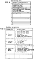
- Fig. 2 and Fig. 3 show examples of arrangement of major data files stored in the information storage unit 3 shown in Fig. 1.
- Fig. 2(A) shows a guidance road data file where data for the route calculated by the route calculating means and data necessary for route guidance is stored.
- roads For each of the roads ("n" in quantity), road number, length, road attribute data, address and size of shape data, and address and size of guidance data are provided.
- a road number is set for each road segment between branch points and for both an outward course and a return course.
- the road attribute data are as shown in Fig. 3 (A) and are the data for information such as overpass, road alongside overpass, underpass, road alongside underpass, or number of lanes.
- the shape data includes, as shown in Fig. 2(B), coordinate data such as eastern longitude or northern latitude for each of plural nodes ("m" in quantity), with each road being divided into a plurality of nodes.
- the guidance data consists of data for intersection (or branch point) name, presence or absence of traffic signal, pedestrians' crossing, distinctive object at branch point or landmark (traffic signal, traffic sign, signboard of filling station or convenience store), precaution information (railroad crossing, tunnel entrance, tunnel exit, road width reduced point, etc.), name of road (such as expressway, general road road type such as national road, prefectural road, and others), address and size of road name sound, address and size of destination data, etc.
- the precaution data includes data for railroad crossing, tunnel entrance, tunnel exit, road narrowing (lane reduction) point, or no information.
- the road name data includes information on type of road such as expressway, municipal expressway, toll road, general road (national road, prefectural road, others) and through lanes or local lanes in expressway, municipal expressway and toll road.
- the destination data includes information as to destination road number, destination name, address and size of destination name sound data, and destination direction data and driving guidance data, i.e. guidance messages such as "bear right", “bear left”, or "bear toward center”.
- the destination direction data includes information such as invalid (destination direction data is not used), not necessary (no guidance provided), straight ahead, rightward direction, diagonally rightward direction, direction to return to right, leftward direction, diagonally leftward direction, and direction to return to left.
- the driving guidance data includes, as shown in Fig. 3(D), data for providing guidance as to which lane the vehicle should be driven in and for guidance messages such as "bear right", “bear left”, “bear toward center”, or "no information”.
- traffic signals and landmarks are recognized by their image, and information such as presence or absence of traffic signals or landmarks (data of Fig. 2) and the driving guidance data of Fig. 3(D) need not necessarily be provided. If these data are stored, they should be rewritable.
- information relating to the shape and color of the feature is stored as acquired image data in the image data file.
- information relating to the shape and color of the feature is stored as acquired image data in the image data file.
- distinctive objects data for shape patterns correlated with shape pattern numbers are stored, and this data is searched to judge whether or not the acquired image data includes one of the distinctive objects identified as such in the stored data.
- intersection data In the data structure shown in Fig. 2, information relating to intersections is stored in the road data, while intersection data may be stored in a separate file, and information such as presence or absence of traffic signals and connecting roads may also be stored in separate files.
- it is better to include information on connecting roads within the road data because it is thereby easier to provide information such as "no entry" being allowed to a road from another road, and the amount of data stored may be reduced.
- Fig. 5 shows examples of guidance phrase data.
- Guidance is provided divided into phrases such as distance phrases, direction phrases, distinctive object phrases, etc.
- these phrases are combined together, and a message such as "Turn right about 300 meters ahead" is output at the preset guidance point in advance of where the turn it to be made.
- Fig. 6 is a flow chart of the main routine for operating the entire navigation system of the present invention.
- execution of the navigation program is started by CPU 40 of the central processing unit 4, the present position is detected by the present position detecting unit 2, and a map of the vicinity around the present position is displayed, along with display of the name and other information pertaining to the present position (Step S1).
- a destination is set by input of a telephone number, address, name of facility, registered point, etc. (Step S2), and the optimal route from the present position to the destination is determined by search (Step S3).
- the route to the destination is set as a guidance road with the numbers of the roads to be travelled arranged as shown in Fig. 7.
- the route to reach the destination is displayed (Step S4).
- the present invention relates to processing of guidance information pertaining to an intersection in the guidance and display of Step S4.
- Fig. 8 to Fig. 19 all pertain to a first embodiment of the present invention.
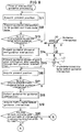
- Fig. 8 and Fig. 9 together are a flow chart of a routine for processing of intersection guidance by guidance control means in the guidance and display step S4 of Fig. 6.
- Fig. 10 shows a screen display representing the output of that processing.
- Step S14 When the vehicle reaches the point at the first predetermined distance in advance of the intersection (L1), a guidance phrase for that next intersection (3) is prepared (S14).
- a guidance message is output to provide guidance along the preset route, such as "Turn left at about 300 meters ahead,” derived from the guidance voice data of Fig. 5.
- Step S15 when it is judged that the vehicle has passed through the intersection for which guidance information has been provided, the message of guidance information relating to the route to be output next is prepared, e.g. a message such as "Turn right about 2 kilometers ahead", or "Drive along this road for a while", etc.
- Step S16 after the present position of the vehicle is again acquired, the distance is calculated from the present position of the vehicle to the next intersection for which guidance is to be provided and it is judged whether or not that calculated distance is at or within a second predetermined distance in advance of that next intersection (S17).
- guidance information for that intersection (3) is output (S18).
- the guidance statement for the next intersection (4) may be prepared at the first predetermined distance preceding the approaching intersection (3), and the guidance message for that next intersection (4) may be output when it is judged that the vehicle has passed through the intersection (3) for which guidance information has been most recently provided.
- Step S19 the data for the traffic signal at the upcoming intersection is retrieved from the guidance data stored in the information storage unit 3 based on the road numbers included in the preset route, and it is judged whether or not there are traffic signals ((3)F and (3)R in Fig. 10) on either the entrance side or the exit side of the upcoming intersection on the entry road (S20). If there is no traffic signal on either side, the processing is completed. In case it is judged that there are traffic signals on both sides in Step S20, the routine advances to Step S21 of Fig. 9.
- the traffic signal (3)F before the intersection is recognized, and the distance to the recognized traffic signal (before the intersection) is compared with the distance from the present position on the map to that traffic signal (S22), and it is judged whether or not this is within the predetermined distance (S23).
- the judgment in Step S23 is made to prevent erroneous recognition in the case where there is a traffic signal at another intersection preceding the next guidance intersection (intersection for which guidance is to be provided).
- Step S23 movement of the vehicle relative to the traffic signal (before the intersection) is traced (S24), and it is judged whether or not the vehicle has passed that traffic signal in Step S25.
- a judgment that a traffic signal has been passed should be accompanied by movement of an image of the traffic signal to the upper portion of the display (recognition) screen and off of the screen.
- the traffic signal (3)R (before the intersection) is recognized (S26), and advancing road judgment (identification of road travelled) processing is performed to determine how the traffic signal (3)R on the exit side of the intersection has moved on the recognition screen of Fig. 10 (S27).
- S28 preset route
- S29 next guidance message
- off-route processing is performed (S30).
- Fig. 11 is a flow chart of a subroutine for detection of a traffic signal in Step S19 of Fig. 8.
- light sources having colors (blue, yellow and red) and luminance within the predetermined range are identified (S31).
- data for the three colors and the luminance range are stored in advance in the information storage unit 3.
- size of the light source is determined (S32), and those sources having a size indicating them to be outside of the predetermined range are eliminated (S33).
- distance from the present position to each of the light sources identified as being within the predetermined range is calculated according to the size of the acquired light source (S34).
- the height of the light source may be identified and those light sources having heights outside of a predetermined range eliminated.
- the shape (circular) of a traffic signal may be stored, and light sources may be categorized by comparison with the stored shape.
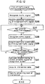
- Fig. 12 is a subroutine for identification of the road travelled based on relative movement of the traffic signal in Step S27 of Fig. 9.
- the traffic signal (on exit side of the intersection) is recognized on the recognition screen (S35), and positional coordinate a 0 for the image of the recognized traffic signal is acquired (S36).
- the traffic signal (on exit side of the intersection) is recognized (S38), and positional coordinate a 1 of the recognized traffic signal is acquired (S39).
- the subroutine (Fig. 12) for determining the road advanced on from the intersection will now be described.
- the stored guidance road data (Fig. 3) or the stored intersection data (Fig. 4) includes data for the connecting relationship of the roads at the intersection. Based on the connecting relationship, the road taken in advancing from the intersection and shape of that road may be identified. Based on the shape of that road, a table is prepared to identify the road taken upon exiting the intersection, based on relative direction (vector) of movement of the traffic signal on the recognition screen.
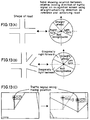
- Figs. 13(A) and (B) each represents a table to identify the road taken exiting the intersection based on direction of relative movement (vector) of the traffic signal and image recognition of the road shape.
- Fig. 13(A) shows the case of a 4-way intersection
- Fig. 13(B) shows the case of a 5-way intersection.
- the relative direction of movement (vector) of the traffic signal based on image recognition is obtained, and it is judged whether it is "straight ahead", “right turn”, “left turn”, or “not recognizable,” depending upon the area in which the vector is directed, using the direction of straight advance (direction of the arrow in the table) as reference. For example, in case the recognized position of the traffic signal moves relatively to the right as shown in Fig.
- the tables shown in Figs. 13(A) and (B) may be stored in advance for each intersection on the preset road, or calculation may be made when providing guidance for an intersection.
- Fig. 14 to Fig. 17 represent flow charts of the routine for off-route processing, i.e. Step S30 of Fig. 9.
- Step S51 of Fig. 14 it is judged whether or not the auto re-route mode has been activated. This is a judgement as to whether or not the user has selected the switch for the automatic re-searching mode. If the automatic re-search switch is ON, re-search processing is automatically performed (S52), and the new route is displayed (S53). If not in the auto re-search mode, the routine advances to Step S54 of Fig. 15, and re-search processing is performed. Next, it is judged whether or not the re-search switch is on. If it is NOT, the routine returns to S54.
- Step S56 it is judged whether or not the vehicle is on new route determined by the re-search (S56). If it is on the newly determined route, the new route is displayed (S57). If it is not on the newly suggested route, the routine returns to Step S54. Thus, if it is in the auto re-route mode, re-search processing is performed before the re-search switch is turned on, and the newly determined route can be output as soon as the re-search switch is turned on.
- Fig. 16 is a flow chart showing an example of re-search processing of Fig. 14 (step S52) and Fig. 15 (step S54).
- search data related to the vicinity of the present position of the vehicle is read (S58), and the previous guidance route (guidance road number data of Fig. 7) is acquired (S59), and the direction of advance and penalty (cost) at each intersection on the route to return to the previous guidance route are calculated (S60).
- the penalties are usually set based on required travel time, distance, ease of driving (road width, or road type such as national road), road tolls, etc., for each numbered road segment.
- the penalties are assessed based on the distance, the ease of the drive based on road width, road type, etc., are converted to equivalent distance values.
- the adjusted distance is shorter for an expressway than for a main road of the same length but with access not so limited, while the adjusted distance is longer yet for a branch road.
- a correcting route for return to the previous guidance route a given value or a multiplying factor is subtracted from the converted distance.
- the optimal route is easily selected from among the candidates.
- the road and the direction of travel at the present position of the vehicle are determined (S61), and intersections connecting with the road in advance of the present position are selected. Based on the direction of advance and the penalties accumulated at each intersection, the route for return to the previous guidance route is determined (S62), and a series of guidance route roads is again connected (S63).
- Fig. 17 is a flow chart of another routine for re-searching processing.
- searching is performed only with search data related to the vicinity of the present location of the vehicle, and a route may not be obtainable because of conditions such as closing of a road. For this reason, all routes leading to the destination are re-searched in the present embodiment.
- the road and the direction at the present position of the vehicle are determined (S64), and the destination road is acquired (S65).
- road data for a route between the present position and the destination is read (S66).
- intersections connecting with the road of the present location in the direction of advance are identified and penalties therefor are evaluated and all routes leading to the destination are evaluated in this manner to select a new optimal route in the form of a series of numbered guidance route roads.
- the original route may be left on the display screen and may be indicated as the leading road, or the area of the vicinity for which search data is currently stored may be enlarged, or the search mode may be switched to a search of all routes leading to the destination as shown in Fig. 17.
- execution of the re-search routine may be initiated when it is judged that the vehicle has advanced onto a road which is off of the route determined and set in advance, thus eliminating loss of time in output of a new guidance route.
- Fig. 18 and Fig. 19 show a routine for branch point guidance by the guidance control means.
- data for the branch point for which guidance is to be next provided is retrieved from the route data (S72).
- the distance from the present position of the vehicle to the branch point is calculated, and it is judged whether or not the present position is in advance of the branch point by the first predetermined distance (S73).
- the guidance message for the next branch point is prepared (S74).
- a guidance message such as "Turn left about 300 meters ahead" is prepared based on the guidance voice data of Fig. 5.
- Step S75 after the vehicle has passed through the branch point as instructed, the guidance message relating to the route to be next communicated to the driver is prepared.
- a message providing guidance after a turn is prepared, such as "Turn right at about 2 kilometers ahead” or “Drive along this road for a while", etc.
- Step S76 after the present position of the vehicle has been again determined, the distance from the present position of the vehicle to the intersection where guidance is to be provided is calculated, and it is judged whether or not it is within a second predetermined distance in advance of the branch point (S77), and when the vehicle reaches a point in the second predetermined distance in advance of the branch point, the guidance for the branch point is output (S78).
- Step S79 the data for a distinctive feature at the branch point is retrieved based on the image of the area ahead.
- the distinctive feature (object) may be a yellow flashing lamp on a divider strip at the branch point, a mark appearing on a divider strip (painted on concrete), a signboard of a filling station, pedestrians' crossing, etc.
- Step S80 it is judged whether or not there is a distinctive object shown on the recognition screen (S80). If not, the routine is completed. In the case where it is decided that there is no distinctive object, the routine advances to Step S81 of Fig. 19. Then, a distinctive object at the branch point is recognized, and the distance to the recognized distinctive object is compared with the distance between the present position of the vehicle on the map and the position of the distinctive object (S82), and it is judged whether this distance is within the predetermined distance (S83). If it is judged to be within the predetermined distance (step S83), travel relative to the distinctive object is traced (S84), and a determination is made as to how the distinctive object has moved on the recognition screen (S85). Next, it is judged whether or not the road of advancing travel is consistent with the preset route (S86). If it is consistent, the next guidance message is output (S87). If not, the off route routine is executed (S88).
- the fact that the vehicle is off of the suggested route may be communicated by voice or by display.
- the driver can take the necessary action at an earlier point in time.
- the driver may be notified that the route will be re-searched and that the vehicle will be guided along a new route.
- map matching is usually performed based on the present position detected by the present position detecting means and road data stored in the information storage unit, and route guidance is provided based on the present position obtained by the map matching. Only in the case where there is data for a distinctive object at the intersection or branch point immediately ahead of the vehicle, the driver is instructed to turn right or left, based on image recognition. The driver may also be notified whether route guidance is based only on the usual map matching or on image recognition, by display or by voice.
- Fig. 13 shows a table illustrating the path of advance through intersection relative to each road entering the intersection, based on the relative direction of movement of the distinctive object on the recognition screen. While only a range for relative direction of movement of the recognized image may be determined to identify the direction of advance along the present determined route ("suggested route") in order to determine whether or not the vehicle has advanced along the suggested route at each intersection, and if outside of the range for such a determination, operation may be switched to the off route search routine.
- a vector of the direction of movement is obtained from the difference between coordinates at two points.
- the direction in which the camera is pointed may be moved in such manner that the first recognized position of the recognized distinctive object is brought to the center of the recognition screen and this position is fixed, and then the direction of movement may be obtained, depending upon the direction and distance of movement of the image the distinctive object out of the camera's field of view.
- the direction of movement of the distinctive object can be determined on the recognition screen (display screen).
- the above embodiment has been described as providing guidance by voice messages such as "right turn” or “left turn” at the intersection or the branch point where the vehicle must turn right or left to follow the suggested route.
- this can be applied to a location type navigation system, in which no route is preset and guidance is provided simply by overlapping the present position of the vehicle on a map, or to a simplified navigation system, in which no map is displayed and the name of the currently travelled road, name of the next intersection and/or distance to the next intersection is output based on the present position of the vehicle.
- this invention can be applied to a system for route guidance, sequentially providing arrow indicators for right turn, left turn, etc., at the next intersection, or to a system where guidance by voice and guidance by display are simultaneously provided.
- the present invention can be applied to any type of navigation system, by addition of the capability for recognition of a distinctive object at intersection or branch point in an image, for determination of direction of advance of the vehicle by determination of the direction of relative movement of the object in the image, and for biasing output of guidance information upon identification of the road taken in advancing through the intersection or branch point.
- Fig. 20 to Fig. 31 all relate to a second embodiment of the present invention.
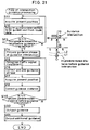
- Fig. 20 is a block diagram of hardware for providing the route guidance for an intersection (Step S4).
- the route setting means 4A calculates a route based on the information input through the input means 11 and on the guidance road data 3A stored in the information storage unit 3, and the route thus set is stored in the route storage means 4B.
- the present position detected by the present position detecting unit 2 is on the route currently under guidance and stored in the route storage means 4B, the data relating to intersections for which guidance is needed ahead of the present position is read from the guidance road data 3A and the guidance expression data 3B in the information storage unit 3, and a guidance message such as "Turn right about 300 meters ahead” or “Turn right at the next traffic signal” relating to the next intersection for which guidance is to be provided is set by the guidance expression setting means 4D which controls the timing of output of the guidance message by the display means 12 and voice output means 16 of the output unit.
- traffic signals, signboards of filling stations, family restaurants, convenience stores, etc., road signs indicating driving lanes, "no entry", etc. are recognized in the image of the road area ahead of the vehicle by the image recognition means ("distinctive object recognizing means") 4G. Based on the size of characters and images, distance between the vehicle and the distinctive object at an intersection is calculated. In case of a traffic signal, operating with the colors of red, yellow and green, the color of the light currently turned on at the signal is recognized and detected. In the case of signboards for filling stations and the like or road signs, characters and images are recognized and detected.
- the judging means 4F judges the position of the distinctive object, e.g. traffic signal, thus recognized relative to the guidance point such as an intersection, and the guidance information correcting means 4E appropriately corrects the guidance information. For example, if the guidance message set according to the foregoing judgment process is "Turn right about 300 meters ahead", the message may be corrected to a more easily understandable message such as "Turn right at the next traffic signal". If, for example, the set guidance message is "Turn right at the next traffic signal" but another traffic signal has been installed, the message is corrected to one such as "Turn right about 300 meters ahead" or "Turn right at the second traffic signal".
- the guidance expression output position determining means 4H determines the position for output of the guidance message set by the guidance expression setting means 4D, based on the judgment of the judging means 4F.
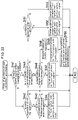
- Fig. 21 illustrates a routine for operation of the guidance control means of Fig. 20 and serves to explain the generation of intersection guidance.
- the present position of the vehicle is determined (Step S111), and data for the guidance intersection for which guidance is to be next provided is acquired from the route data (Step S112). Then, based on the present position information thus acquired and the retrieved route data, distance from the present position to the next guidance intersection (intersection for which guidance is to be provided) is determined, and a judgement is made as to whether or not that determined distance is within the first predetermined distance in advance of the guidance intersection (Step S113).
- a guidance message for the guidance intersection is prepared (Step S114).
- a message based on the guidance voice data of Fig. 5 is prepared to provide guidance based on the determined route, such as "Turn left about 300 meters ahead.”
- Step S115 traffic signals or signboards for filling stations or the like are detected in the video image of the area ahead of the vehicle (by the routine of Fig. 11).
- the previously prepared guidance message is corrected to provide a more easily understandable message such as "Turn left at the signal", "Turn left at the next filling station", etc. (routine illustrated in Fig. 22) (Step S116).
- the present position is determined (Step S117), and the guidance distance is corrected (routine of Fig. 24) in Step S118.
- Steps S117 - S119 distance is determined from the present position information thus acquired and the route data, and it is judged whether or not that determined distance is within the second predetermined distance preceding the next guidance intersection. Until the vehicle reaches the point (L2) a second predetermined distance ahead of the intersection, the procedure of Steps S115 - S118 is repeated. When the vehicle reaches the point (L2), the corrected guidance phrase is output, and further, additional guidance output (routine of Fig. 27) is executed.
- a guidance message is prepared at the predetermined distance before the guidance intersection; however, the guidance message may be prepared immediately after the completion of guidance output at the guidance intersection which precedes the guidance intersection in question, and it may be retained in means such as RAM, or it may be prepared in advance after the route has been set.
- Signboards for filling stations or the like may also be recognized.
- information relating to the image, size, height, etc. of signboards for each (oil) company may be stored in the information storage unit 3 in advance.
- the signboards located within a predetermined range from the scenery image ahead of the vehicle are detected, and the distance to each of the signboards is calculated.
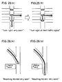
- Fig. 22 shows a routine for guidance message correction (step S116 Fig. 21), and Figs. 23(A)-23(F) are a series of drawings illustrating specific examples.
- Step S141 it is judged whether there is a traffic signal within the predetermined range (distance to the guidance intersection) (Step S141). If not, it is judged in Step S142 whether there is a signboard for a filling station or the like. If there is, it is judged whether or not it is within the predetermined range from the guidance intersection (Step S143). If it is within the predetermined range, the guidance message is changed in Step S144 to "Turn at the intersection where the filling station is located" (Fig. 23 (A)).
- Step S145 it is judged in Step S145 whether or not the traffic signal is within the predetermined range from the guidance intersection. If it is within the predetermined 10 range, it is judged in Step S146 whether or not that traffic signal is before the guidance intersection. If not, the guidance message is changed to "Turn right at the next traffic signal" in Step S147 (Fig. 23 (B)).
- Step S146 If it is judged in Step S146 that there is a traffic signal before the guidance intersection, the number (n) of the traffic signals is determined. After the guidance message is changed to "Turn right at n-th traffic signal" in Step S149 (Fig. 23 (C)), the message “Turn right at the next traffic signal," for additional guidance, is prepared in Step S150 (Fig. 23 (D)), and the predetermined distance from the guidance intersection is set.
- the purpose of this additional guidance is to provide reliable guidance in the case that two or more intersections are located within relatively short distance of each other.
- Step S151 If the detected traffic signal is not within the predetermined range from the guidance intersection, it is judged in Step S151 whether or not it is before the guidance intersection. If it is before the intersection, the guidance message is changed in Step S151 to "Turn right at the next intersection after the traffic signal" (Fig. 23 (E)). If it is not before the intersection, the guidance phrase is changed in Step S153 to "Turn right at the intersection before the traffic signal" (Fig. 23 (F)).
- Fig. 24 shows the routine for guidance distance correction in Step S118 of Fig. 21.
- the remaining distance (1) to the guidance intersection is determined (Step S161), and the distance (2) to the traffic signal of the guidance intersection is determined by recognition of a traffic signal in the image for the area ahead of the vehicle (Step S162).
- Step S163 it is judged whether or not the absolute value of the difference between the distances (1) and (2) is within a predetermined range (Step S163). If it is within the predetermined range, it is left unchanged. If it is not within the predetermined range, the distance (2) is adopted as the second predetermined distance to provide guidance for the guidance intersection.
- Figs. 25(A)-25(B) An example of guidance distance correction in accordance with the routine of Fig. 24 is shown in Figs. 25(A)-25(B).
- the timing for guidance may be off. Therefore, to provide reliable guidance, the traffic signal at the guidance intersection is recognized in the image of the area of the road ahead, the guidance distance is corrected, and a guidance message such as "Turn right at the next traffic signal," is output as shown in Fig. 25 (B) at proper timing for this guidance distance.
- the guidance message "Turn right about 50 meters ahead" may be output depending on the distance to the traffic signal.
- the timing of guidance for that expressway exit may be delayed. Therefore, by recognizing the actual exit sign in the video image and by providing guidance based on that detection of the actual exit sign, reliable guidance can be provided sufficiently in advance of the exit as shown in Fig. 26(B). In case the position of intersection or branch point as stored in the data base has changed or is otherwise inaccurate, the data base may be re-written and maintenance may be performed.
- Fig. 27 shows a routine for providing additional guidance output (Step S121 of Fig. 21). Firstly, a judgement is made as to whether or not an additional guidance message has been set in Step S150 of Fig. 22. If set, it is judged whether or not the vehicle is within the predetermined distance. When the vehicle reaches the point at the predetermined distance, the preset additional guidance message is output.
- Figs. 28(A) and 28(B) The case where correction of the guidance message is required by installation or removal of a traffic signal is illustrated in Figs. 28(A) and 28(B).
- Fig. 28(A) the intersection (1) of the road data "a" of the guidance route is stored in a data base as “without traffic signal”, and it is described as “without traffic signal” in guidance. Thus, guidance is provided as "Turn right at the next traffic signal".
- Fig. 28(B) in case a traffic signal is newly installed at the intersection (1), the guidance message will not agree with the actual situation.
- the guidance message may be changed to "Turn right at the second traffic signal" by taking the new traffic signal into account or a general guidance message such as "Turn right about 300 meters ahead” is issued at an appropriate distance from the guidance intersection (2).
- the data base When the contents stored in the data base are different from the data obtained by the image recognition, the data base should be updated.
- a traffic signal has been added at intersection (1).
- the data for the traffic signal in the stored guidance data - Fig. 2(C)
- the data for the traffic signal is changed from "absent" to "present”.
- landmarks stored in the data base in advance as patterns, if a newly constructed landmark is detected in the video image, data for the new landmark is added to the guidance data.
- landmark in case of landmark is present in the data base which can not be recognized in the video image, it may be deleted from the data base.
- a landmark present in the data base which can not be recognized in the video image, it may be behind some object hiding it from view, in which case the data base may be left unchanged, and it may remain stored in the road data to provide general guidance as described above in connection with the intersection in question.
- Fig. 29 illustrates another example of a guidance message change in the present invention.
- the lane where the vehicle is currently driven is recognized.
- guidance data may be changed or added.
- the guidance message "right turn” is provided at the intersection (with traffic signal) after the intersection in Fig. 29, and guidance is provided such as "Turn right at the next intersection. Take special care to enter the lane for right turn at the intersection before" or "Turn right at the next intersection. You are driving in the right-turn lane. Confirm this, and move to through lane". If the intersection of Fig.
- the traffic signs for the lanes may be recognized and lane guidance may be provided by specifying the lane where the vehicle is currently driven. Even when lane information is stored in the data base, the actual lane configuration may be changed by expansion of the road or otherwise, and more accurate guidance may be provided by image recognition of the current lane conditions. The information obtained by image recognition may be stored in the data base and may be output in the next route guidance based on the result of this learning.
- Fig. 30 and Fig. 31 relate to another example of a guidance message change in the present invention.
- traffic regulation of the road has been changed to newly create a one-way road, and the route leading to one-way road is part of the preset guidance route.
- this road is discarded and re-searching is automatically performed.
- the data for the road on which the vehicle is currently travelling is acquired (Step S190), and the "no entry" sign along the route is recognized (Step S191). If there is such a sign, the position closest to the sign on the route is acquired (Step S192). As shown in Fig.
- Step S193 it is judged whether or not the search has successfully identified a new route. If not, a "no entry" precaution message is output as shown in Fig. 31(A) (Step S195). If a new route has been identified by searching, the new route is output as shown in Fig. 31(C) (Step S196). In the case of a one-way road, there will be a sign such as "no right turn” shown in Fig. 31(D), in addition to the "no entry” sign. In such a case, the "right turn” road is discarded, and re-searching is performed.
- a distinctive object such as a traffic signal at a guidance point is imaged, and guidance is added or corrected based on the present status of the distinctive objects such as traffic signals.
- guidance can be provided in a more easily understandable manner.
- the location for output of the guidance is determined according to position of the vehicle relative to the distinctive object and the guidance point, and guidance can be provided adequately in advance.
Landscapes
- Engineering & Computer Science (AREA)
- Radar, Positioning & Navigation (AREA)
- Remote Sensing (AREA)
- Physics & Mathematics (AREA)
- General Physics & Mathematics (AREA)
- Automation & Control Theory (AREA)
- Mathematical Physics (AREA)
- Multimedia (AREA)
- Navigation (AREA)
- Traffic Control Systems (AREA)
Applications Claiming Priority (6)
| Application Number | Priority Date | Filing Date | Title |
|---|---|---|---|
| JP7338662A JPH09178497A (ja) | 1995-12-26 | 1995-12-26 | 車両用ナビゲーション装置 |
| JP33866295 | 1995-12-26 | ||
| JP338662/95 | 1995-12-26 | ||
| JP134545/96 | 1996-05-29 | ||
| JP13454596 | 1996-05-29 | ||
| JP13454596 | 1996-05-29 |
Publications (2)
| Publication Number | Publication Date |
|---|---|
| EP0782118A1 true EP0782118A1 (fr) | 1997-07-02 |
| EP0782118B1 EP0782118B1 (fr) | 2003-05-21 |
Family
ID=26468632
Family Applications (1)
| Application Number | Title | Priority Date | Filing Date |
|---|---|---|---|
| EP96119899A Expired - Lifetime EP0782118B1 (fr) | 1995-12-26 | 1996-12-11 | Système de navigation pour véhicules |
Country Status (4)
| Country | Link |
|---|---|
| US (1) | US6018697A (fr) |
| EP (1) | EP0782118B1 (fr) |
| KR (1) | KR100224326B1 (fr) |
| DE (1) | DE69628274T2 (fr) |
Cited By (34)
| Publication number | Priority date | Publication date | Assignee | Title |
|---|---|---|---|---|
| EP1096228A1 (fr) * | 1998-06-18 | 2001-05-02 | Sanyo Electric Co., Ltd. | Dispositif de navigation |
| WO2001057475A1 (fr) * | 2000-02-04 | 2001-08-09 | Robert Bosch Gmbh | Procede et dispositif de gestion de perturbations de la circulation pour appareils de navigation |
| EP1130356A1 (fr) * | 2000-02-21 | 2001-09-05 | BECKER GmbH | Système de navigation pour véhicule |
| EP1134549A2 (fr) | 2000-03-15 | 2001-09-19 | Robert Bosch Gmbh | Système de navigation |
| WO2001099079A1 (fr) * | 2000-06-23 | 2001-12-27 | Robert Bosch Gmbh | Systeme et procede d'information sur la circulation routiere |
| EP1215469A1 (fr) * | 2000-12-14 | 2002-06-19 | Pioneer Corporation | Appareil de navigation, méthode de navigation et support d'information sur lequel est enregistré un programme de navigation lisible par ordinateur |
| EP1229306A1 (fr) * | 2001-02-06 | 2002-08-07 | Honda Giken Kogyo Kabushiki Kaisha | Appareil de navigation donnant la direction de déplacement d'un mobile |
| EP1271446A1 (fr) * | 2001-06-18 | 2003-01-02 | Origin Technologies Limited | Système d'avertissement et de détection de la présence d'un appareil de contrôle de vitesse |
| EP1271448A1 (fr) * | 2001-06-20 | 2003-01-02 | Siemens Aktiengesellschaft | Procédé pour un tachygraphe de véhicule au moyen de communication radio |
| EP1343129A1 (fr) * | 2002-03-08 | 2003-09-10 | Navigation Technologies Corporation | Procédé et système utilisant les camions de livraison pour le recueil des données de localisation d'adresse |
| EP1359557A1 (fr) * | 2002-04-30 | 2003-11-05 | Matsushita Electric Industrial Co., Ltd. | Système de navigation pour un véhicule qui traduit automatiquement les panneaux et les objets de routiers |
| EP1491857A1 (fr) * | 2003-06-26 | 2004-12-29 | Harman Becker Automotive Systems GmbH | Procédé d'assistance de navigation et système de navigation |
| FR2866951A1 (fr) * | 2004-02-26 | 2005-09-02 | Bosch Gmbh Robert | Procede de guidage d'utilisateur d'un systeme de navigation ainsi que systeme de navigation pour la mise en oeuvre du procede |
| EP1659029A1 (fr) * | 2004-11-17 | 2006-05-24 | Aisin Aw Co., Ltd. | Appareil et méthode d'alerte de proximité de véhicule |
| US7183942B2 (en) | 2000-01-26 | 2007-02-27 | Origin Technologies Limited | Speed trap detection and warning system |
| EP1909247A1 (fr) * | 2005-09-30 | 2008-04-09 | Aisin Aw Co., Ltd. | Système de création de base de données de cartes |
| EP1975564A2 (fr) | 2007-03-30 | 2008-10-01 | Aisin AW Co., Ltd. | Appareil d'apprentissage du comportement de véhicule et programme d'apprentissage du comportement de véhicule |
| EP1975565A3 (fr) * | 2007-03-30 | 2009-11-04 | Aisin AW Co., Ltd. | Appareil de collecte d'informations caractéristiques et procédé de collecte d'informations caractéristiques |
| EP1975563A3 (fr) * | 2007-03-30 | 2009-11-04 | Aisin AW Co., Ltd. | Appareil de collecte d'informations de caractéristiques et procédé de collecte d'informations de caractéristiques |
| EP2113746A1 (fr) | 2007-12-27 | 2009-11-04 | Aisin AW Co., Ltd. | Dispositif de collecte d'informations de propriétés et programme de collecte d'informations de propriétés, et dispositif de reconnaissance de la position du véhicule et dispositif de navigation |
| EP1975558A3 (fr) * | 2007-03-30 | 2009-11-04 | Aisin AW Co., Ltd. | Appareil et procédé de reconnaissance d'image |
| EP2208967A1 (fr) | 2009-01-20 | 2010-07-21 | Alpine Electronics, Inc. | Système de navigation comprenant une fonction d'orientation routière et procédé de recherche d'itinéraires |
| EP2214122A1 (fr) | 2009-02-03 | 2010-08-04 | Harman Becker Automotive Systems GmbH | Procédés et dispositifs pour aider le conducteur d'un véhicule |
| EP2241859A1 (fr) * | 2007-12-31 | 2010-10-20 | STMicroelectronics Design and Application GmbH | Système amélioré de navigation de véhicule |
| EP2472229A1 (fr) * | 2010-12-28 | 2012-07-04 | Aisin AW Co., Ltd. | Dispositif de navigation, procédé et support de programme informatique associés |
| WO2012111258A1 (fr) * | 2011-02-16 | 2012-08-23 | Aisin Aw Co.,Ltd. | Dispositif, procédé et programme de guidage |
| WO2012132619A1 (fr) * | 2011-03-31 | 2012-10-04 | Aisin Aw Co., Ltd. | Système de guidage de parcours, appareil de guidage de parcours, procédé de guidage de parcours et programme d'ordinateur |
| US8825353B2 (en) | 2007-09-28 | 2014-09-02 | Aisin Aw Co., Ltd. | Parking support systems, parking support methods, and parking support programs |
| US8892517B2 (en) | 2006-06-09 | 2014-11-18 | Aisin Aw Co., Ltd. | Data updating system, navigation device, server, and method of data updating |
| EP3018448A1 (fr) * | 2014-11-04 | 2016-05-11 | Volvo Car Corporation | Procédés et systèmes permettant d'améliorer le positionnement d'un véhicule |
| EP1114371B2 (fr) † | 1998-09-15 | 2018-10-31 | Robert Bosch Gmbh | Procédé et dispositif pour la reconnaissance de signaux routiers et la navigation |
| CN108955712A (zh) * | 2017-05-18 | 2018-12-07 | 佛山市顺德区顺达电脑厂有限公司 | 预览拍摄影像的方法及多镜头行车记录系统 |
| US20190179331A1 (en) * | 2017-12-08 | 2019-06-13 | Lg Electronics Inc. | Vehicle control device mounted on vehicle and method for controlling the vehicle |
| DE102018210528A1 (de) | 2018-06-27 | 2020-01-02 | Bayerische Motoren Werke Aktiengesellschaft | Verfahren zum Betreiben eines Dialogsystems |
Families Citing this family (134)
| Publication number | Priority date | Publication date | Assignee | Title |
|---|---|---|---|---|
| KR100291088B1 (ko) * | 1997-02-07 | 2001-09-17 | 가시오 가즈오 | 이동단말장치에정보를제공하기위한네트워크시스템 |
| EP0922201B1 (fr) * | 1997-07-01 | 2002-09-11 | Siemens Aktiengesellschaft | Systeme de navigation a utiliser dans un vehicule |
| GB2328744B (en) * | 1997-08-28 | 2002-02-13 | Denso Corp | Route guidance apparatus |
| JP3371768B2 (ja) * | 1997-08-29 | 2003-01-27 | 株式会社デンソー | 車両用走行経路案内装置およびその地図データ記録媒体 |
| US6256582B1 (en) * | 1997-11-18 | 2001-07-03 | Mannesmann Vdo Ag | Method and device for navigation support of a vehicle driver |
| JP3535724B2 (ja) * | 1997-12-25 | 2004-06-07 | キヤノン株式会社 | 画像撮像装置およびその方法、並びに記憶媒体 |
| JP3511570B2 (ja) * | 1998-03-06 | 2004-03-29 | パイオニア株式会社 | 地図情報表示装置及びナビゲーション用プログラムを記録した記録媒体 |
| US6697103B1 (en) | 1998-03-19 | 2004-02-24 | Dennis Sunga Fernandez | Integrated network for monitoring remote objects |
| US8543372B1 (en) | 1998-05-18 | 2013-09-24 | Dennis S. Fernandez | System design rights management |
| US6266442B1 (en) * | 1998-10-23 | 2001-07-24 | Facet Technology Corp. | Method and apparatus for identifying objects depicted in a videostream |
| JP2000258179A (ja) * | 1999-03-12 | 2000-09-22 | Denso Corp | 車載用ナビゲーション装置 |
| AU3892100A (en) * | 1999-03-19 | 2000-10-09 | Rct Systems, Inc. | System for indexing pedestrian traffic |
| JP3076026B1 (ja) * | 1999-03-30 | 2000-08-14 | 松下電器産業株式会社 | ナビゲーション装置 |
| JP2000283781A (ja) * | 1999-03-31 | 2000-10-13 | Matsushita Electric Ind Co Ltd | カーナビゲーション装置及びその案内表示方法 |
| US6559865B1 (en) * | 1999-05-21 | 2003-05-06 | Tele Atlas North America, Inc. | Computing sign text for branches of an electronic map network |
| JP2001050767A (ja) * | 1999-08-06 | 2001-02-23 | Aisin Aw Co Ltd | ナビゲーション装置および記憶媒体 |
| US6516273B1 (en) * | 1999-11-04 | 2003-02-04 | Veridian Engineering, Inc. | Method and apparatus for determination and warning of potential violation of intersection traffic control devices |
| DE10103714A1 (de) * | 2000-01-26 | 2001-08-16 | Daimler Chrysler Ag | Verfahren zum Erhalten präziser Straßenkarten |
| CN1261911C (zh) * | 2000-03-14 | 2006-06-28 | 爱信Aw株式会社 | 道路地图显示装置 |
| US6654682B2 (en) * | 2000-03-23 | 2003-11-25 | Siemens Transportation Systems, Inc. | Transit planning system |
| JP3967061B2 (ja) * | 2000-03-28 | 2007-08-29 | アルパイン株式会社 | ナビゲーション装置 |
| JP2001289654A (ja) | 2000-04-11 | 2001-10-19 | Equos Research Co Ltd | ナビゲーション装置、ナビゲーション装置の制御方法、及びそのプログラムを記録した記録媒体 |
| JP3908437B2 (ja) * | 2000-04-14 | 2007-04-25 | アルパイン株式会社 | ナビゲーションシステム |
| US7100825B2 (en) * | 2000-04-20 | 2006-09-05 | Levine Alfred B | Non-computing navigation system |
| US6405131B1 (en) * | 2000-05-22 | 2002-06-11 | Navigation Technologies Corp. | Method and system for providing route guidance with multiple progress bars |
| US8073565B2 (en) | 2000-06-07 | 2011-12-06 | Apple Inc. | System and method for alerting a first mobile data processing system nearby a second mobile data processing system |
| US6456234B1 (en) | 2000-06-07 | 2002-09-24 | William J. Johnson | System and method for proactive content delivery by situation location |
| US6292745B1 (en) * | 2000-07-24 | 2001-09-18 | Navigation Technologies Corp. | Method and system for forming a database of geographic data for distribution to navigation system units |
| US6891960B2 (en) | 2000-08-12 | 2005-05-10 | Facet Technology | System for road sign sheeting classification |
| US6526348B1 (en) | 2000-08-25 | 2003-02-25 | Navigation Technologies Corp. | Method and system for compact representation of routes |
| US7865306B2 (en) * | 2000-09-28 | 2011-01-04 | Michael Mays | Devices, methods, and systems for managing route-related information |
| US6351710B1 (en) * | 2000-09-28 | 2002-02-26 | Michael F. Mays | Method and system for visual addressing |
| US7135961B1 (en) * | 2000-09-29 | 2006-11-14 | International Business Machines Corporation | Method and system for providing directions for driving |
| JP3599698B2 (ja) * | 2001-10-03 | 2004-12-08 | 怡利電子工業股▲ふん▼有限公司 | 指針式カーナビゲーション画面表示方法 |
| US6609063B1 (en) * | 2001-10-12 | 2003-08-19 | Navigation Technologies Corp. | System and method for using a map database with attributed no-outlet and circular segments |
| US8392457B1 (en) | 2001-10-12 | 2013-03-05 | Navteq B.V. | System and method for forming a map database with no-outlet and circular segments |
| JP3895155B2 (ja) * | 2001-11-15 | 2007-03-22 | アルパイン株式会社 | ナビゲーション装置 |
| JP4208487B2 (ja) * | 2002-05-29 | 2009-01-14 | キヤノン株式会社 | 情報処理装置及び位置の表示方法 |
| JP4092976B2 (ja) * | 2002-08-05 | 2008-05-28 | ソニー株式会社 | ガイドシステム、コンテンツサーバ、及び情報処理プログラム |
| US8797402B2 (en) * | 2002-11-19 | 2014-08-05 | Hewlett-Packard Development Company, L.P. | Methods and apparatus for imaging and displaying a navigable path |
| FI115668B (fi) * | 2003-03-25 | 2005-06-15 | Sandvik Tamrock Oy | Kaivosajoneuvon paikan ja suunnan alustaminen |
| US7526718B2 (en) * | 2003-04-30 | 2009-04-28 | Hewlett-Packard Development Company, L.P. | Apparatus and method for recording “path-enhanced” multimedia |
| JP4076905B2 (ja) * | 2003-05-15 | 2008-04-16 | アルパイン株式会社 | ナビゲーション装置 |
| US9341485B1 (en) | 2003-06-19 | 2016-05-17 | Here Global B.V. | Method and apparatus for representing road intersections |
| US8892356B1 (en) * | 2003-06-19 | 2014-11-18 | Here Global B.V. | Method and system for representing traffic signals in a road network database |
| EP1544829B1 (fr) * | 2003-12-19 | 2017-02-15 | Samsung Electronics Co., Ltd. | Méthode et système de navigation |
| US7050909B2 (en) * | 2004-01-29 | 2006-05-23 | Northrop Grumman Corporation | Automatic taxi manager |
| US7133775B2 (en) * | 2004-02-17 | 2006-11-07 | Delphi Technologies, Inc. | Previewing points of interest in navigation system |
| US7590310B2 (en) | 2004-05-05 | 2009-09-15 | Facet Technology Corp. | Methods and apparatus for automated true object-based image analysis and retrieval |
| JP4423114B2 (ja) * | 2004-06-02 | 2010-03-03 | アルパイン株式会社 | ナビゲーション装置およびその交差点案内方法 |
| US7149626B1 (en) * | 2004-06-30 | 2006-12-12 | Navteq North America, Llc | Method of operating a navigation system |
| US8751156B2 (en) | 2004-06-30 | 2014-06-10 | HERE North America LLC | Method of operating a navigation system using images |
| US7421341B1 (en) * | 2004-06-30 | 2008-09-02 | Navteq North America, Llc | Method of collecting information for a geographic database for use with a navigation system |
| JP4466238B2 (ja) * | 2004-07-07 | 2010-05-26 | 株式会社デンソー | 車両用ナビゲーション装置 |
| JP4722433B2 (ja) * | 2004-08-25 | 2011-07-13 | アルパイン株式会社 | 車載用ナビゲーション装置 |
| JP4696248B2 (ja) * | 2004-09-28 | 2011-06-08 | 国立大学法人 熊本大学 | 移動体ナビゲート情報表示方法および移動体ナビゲート情報表示装置 |
| DE102004060432B4 (de) * | 2004-12-14 | 2008-04-10 | Daimler Ag | Verfahren zur Früherkennung von Straßen-Ausfahrten |
| KR101047719B1 (ko) * | 2005-02-16 | 2011-07-08 | 엘지전자 주식회사 | 네비게이션 시스템에서 이동체의 주행경로 안내방법 및 장치 |
| WO2006121986A2 (fr) * | 2005-05-06 | 2006-11-16 | Facet Technology Corp. | Systeme de navigation base sur un reseau presentant des annonces de passage virtuelles integrees a l'imagerie reelle obtenue le long d'une route physique |
| JP4645516B2 (ja) * | 2005-08-24 | 2011-03-09 | 株式会社デンソー | ナビゲーション装置及びプログラム |
| JP2007094045A (ja) * | 2005-09-29 | 2007-04-12 | Matsushita Electric Ind Co Ltd | ナビゲーション装置、ナビゲート方法および車両 |
| JP4470873B2 (ja) * | 2005-11-30 | 2010-06-02 | アイシン・エィ・ダブリュ株式会社 | 経路案内システム及び経路案内方法 |
| JP2007155352A (ja) * | 2005-11-30 | 2007-06-21 | Aisin Aw Co Ltd | 経路案内システム及び経路案内方法 |
| DE102006002376A1 (de) * | 2006-01-17 | 2007-07-19 | Robert Bosch Gmbh | Verfahren und Vorrichtung zur Durchgangsverkehrserkennung |
| JP2007232690A (ja) * | 2006-03-03 | 2007-09-13 | Denso Corp | 現在地検出装置、地図表示装置、および現在地検出方法 |
| JP4631750B2 (ja) * | 2006-03-06 | 2011-02-16 | トヨタ自動車株式会社 | 画像処理システム |
| JP4575491B2 (ja) * | 2006-03-10 | 2010-11-04 | パイオニア株式会社 | ナビゲーション装置及びナビゲーション方法 |
| JP4935145B2 (ja) * | 2006-03-29 | 2012-05-23 | 株式会社デンソー | カーナビゲーション装置 |
| JP4938351B2 (ja) * | 2006-05-16 | 2012-05-23 | トヨタ自動車株式会社 | 車両用測位情報更新装置 |
| JP4724043B2 (ja) * | 2006-05-17 | 2011-07-13 | トヨタ自動車株式会社 | 対象物認識装置 |
| JP2007316018A (ja) * | 2006-05-29 | 2007-12-06 | Denso Corp | 車両用ナビゲーション装置 |
| JP2008009915A (ja) * | 2006-06-30 | 2008-01-17 | Pioneer Electronic Corp | 道路標識判定装置、方法及びプログラム |
| US8566028B2 (en) * | 2006-11-27 | 2013-10-22 | International Business Machines Corporation | Apparatus, system, and method for autonomously determining a set of destinations |
| DE102006062061B4 (de) * | 2006-12-29 | 2010-06-10 | Fraunhofer-Gesellschaft zur Förderung der angewandten Forschung e.V. | Vorrichtung, Verfahren und Computerprogramm zum Bestimmen einer Position basierend auf einem Kamerabild von einer Kamera |
| US20100030462A1 (en) * | 2007-02-15 | 2010-02-04 | Pioneer Corporation | Display control apparatus, display control method, display control program, and recording medium |
| DE102007030345A1 (de) * | 2007-02-28 | 2008-09-04 | Navigon Ag | Navigationseinrichtung und Verfahren zur grafischen Ausgabe von Navigationsanweisungen |
| DE102007015926A1 (de) * | 2007-04-02 | 2008-10-09 | Continental Automotive Gmbh | Erkennung der Einfahrt eines Fahrzeugs in verbotene Bereiche |
| JP4980118B2 (ja) * | 2007-04-06 | 2012-07-18 | アルパイン株式会社 | 車載用ナビゲーション装置 |
| DE102007023765A1 (de) * | 2007-05-22 | 2008-11-27 | Robert Bosch Gmbh | Verfahren und Anordnung zur Ausgabe von Zielführungshinweisen |
| US8290513B2 (en) | 2007-06-28 | 2012-10-16 | Apple Inc. | Location-based services |
| US9066199B2 (en) | 2007-06-28 | 2015-06-23 | Apple Inc. | Location-aware mobile device |
| US8108144B2 (en) | 2007-06-28 | 2012-01-31 | Apple Inc. | Location based tracking |
| US8385946B2 (en) | 2007-06-28 | 2013-02-26 | Apple Inc. | Disfavored route progressions or locations |
| US8762056B2 (en) | 2007-06-28 | 2014-06-24 | Apple Inc. | Route reference |
| US9109904B2 (en) * | 2007-06-28 | 2015-08-18 | Apple Inc. | Integration of map services and user applications in a mobile device |
| US8774825B2 (en) * | 2007-06-28 | 2014-07-08 | Apple Inc. | Integration of map services with user applications in a mobile device |
| US20090005964A1 (en) * | 2007-06-28 | 2009-01-01 | Apple Inc. | Intelligent Route Guidance |
| US8155877B2 (en) * | 2007-11-29 | 2012-04-10 | Microsoft Corporation | Location-to-landmark |
| JP5186903B2 (ja) * | 2007-11-30 | 2013-04-24 | ソニー株式会社 | 地図表示装置と地図表示方法および撮像装置 |
| ES2306616B1 (es) | 2008-02-12 | 2009-07-24 | Fundacion Cidaut | Procedimiento de determinacion de la luminancia de señales de trafico y dispositivo para su realizacion. |
| JPWO2009122633A1 (ja) * | 2008-04-02 | 2011-07-28 | 三菱電機株式会社 | ナビゲーション装置 |
| US8359157B2 (en) * | 2008-04-07 | 2013-01-22 | Microsoft Corporation | Computing navigation device with enhanced route directions view |
| US8751154B2 (en) * | 2008-04-24 | 2014-06-10 | GM Global Technology Operations LLC | Enhanced clear path detection in the presence of traffic infrastructure indicator |
| US20090276153A1 (en) * | 2008-05-01 | 2009-11-05 | Chun-Huang Lee | Navigating method and navigation apparatus using road image identification |
| US20090326815A1 (en) * | 2008-05-02 | 2009-12-31 | Apple Inc. | Position Fix Indicator |
| US9250092B2 (en) | 2008-05-12 | 2016-02-02 | Apple Inc. | Map service with network-based query for search |
| US8644843B2 (en) * | 2008-05-16 | 2014-02-04 | Apple Inc. | Location determination |
| DE102008043756B4 (de) | 2008-11-14 | 2022-09-01 | Robert Bosch Gmbh | Verfahren und Steuergerät zum Bereitstellen einer Verkehrszeicheninformation |
| JP5461065B2 (ja) * | 2009-05-21 | 2014-04-02 | クラリオン株式会社 | 現在位置特定装置とその現在位置特定方法 |
| US9291463B2 (en) * | 2009-08-03 | 2016-03-22 | Tomtom North America, Inc. | Method of verifying or deriving attribute information of a digital transport network database using interpolation and probe traces |
| CN102473347B (zh) * | 2009-09-24 | 2014-06-11 | 三菱电机株式会社 | 行驶模式生成装置 |
| US9070305B1 (en) * | 2010-01-22 | 2015-06-30 | Google Inc. | Traffic light detecting system and method |
| KR101049372B1 (ko) * | 2010-03-03 | 2011-07-14 | 팅크웨어(주) | 내비게이션 시스템, 및 차량용 내비게이션의 제어방법 |
| JP2012002595A (ja) * | 2010-06-15 | 2012-01-05 | Sony Corp | 情報処理装置、情報処理方法、情報処理システム、及びプログラム |
| CN102346481A (zh) * | 2010-07-28 | 2012-02-08 | 何仁城 | 一种车辆的自动驾驶系统 |
| JP5569365B2 (ja) * | 2010-11-30 | 2014-08-13 | アイシン・エィ・ダブリュ株式会社 | 案内装置、案内方法、及び案内プログラム |
| JP5565296B2 (ja) * | 2010-12-21 | 2014-08-06 | アイシン・エィ・ダブリュ株式会社 | 経路案内装置、経路案内方法及びコンピュータプログラム |
| TWI437210B (zh) * | 2011-04-14 | 2014-05-11 | Inst Information Industry | 藉由即時交通規則判斷資訊進行導航之電子裝置、方法以及儲存其之電腦可讀取記錄媒體 |
| US8620032B2 (en) * | 2011-05-10 | 2013-12-31 | GM Global Technology Operations LLC | System and method for traffic signal detection |
| KR20130080186A (ko) * | 2012-01-04 | 2013-07-12 | 삼성전자주식회사 | 위치 정보 태깅을 위한 방법 및 장치 |
| JP5918004B2 (ja) * | 2012-04-27 | 2016-05-18 | 株式会社東海理化電機製作所 | 電子キー登録システム |
| USD730364S1 (en) | 2012-06-05 | 2015-05-26 | Apple Inc. | Display screen or portion thereof with a graphical user interface |
| USD740832S1 (en) * | 2012-06-06 | 2015-10-13 | Apple Inc. | Display screen or portion thereof with a graphical user interface |
| USD739859S1 (en) | 2012-06-06 | 2015-09-29 | Apple Inc. | Display screen or portion thereof with graphical user interface |
| WO2014162797A1 (fr) | 2013-04-04 | 2014-10-09 | 日産自動車株式会社 | Dispositif de reconnaissance de signal |
| US10546441B2 (en) | 2013-06-04 | 2020-01-28 | Raymond Anthony Joao | Control, monitoring, and/or security, apparatus and method for premises, vehicles, and/or articles |
| JP5939230B2 (ja) * | 2013-11-05 | 2016-06-22 | トヨタ自動車株式会社 | 車両位置同定システム及び車両位置同定方法 |
| JP6397827B2 (ja) * | 2013-12-27 | 2018-09-26 | 株式会社シーズ・ラボ | 地図データ更新装置 |
| US9151626B1 (en) * | 2014-04-11 | 2015-10-06 | Nissan North America, Inc. | Vehicle position estimation system |
| JP6318823B2 (ja) * | 2014-04-25 | 2018-05-09 | 株式会社リコー | 自動移動装置 |
| US9707960B2 (en) | 2014-07-31 | 2017-07-18 | Waymo Llc | Traffic signal response for autonomous vehicles |
| US9483937B2 (en) * | 2014-10-16 | 2016-11-01 | Paypal, Inc. | Wireless beacon devices providing crosswalk management through communication device connections |
| DE102014222836A1 (de) * | 2014-11-10 | 2016-05-12 | Robert Bosch Gmbh | Verfahren zum Betreiben eines Fahrerassistenzsystems und Fahrerassistenzsystem |
| USD758390S1 (en) * | 2014-12-30 | 2016-06-07 | Toyota Jidosha Kabushiki Kaisha | Display screen with graphical user interface |
| US9816830B2 (en) | 2015-05-20 | 2017-11-14 | Uber Technologies, Inc. | Navigation lane guidance |
| KR102464587B1 (ko) * | 2015-11-30 | 2022-11-08 | 현대오토에버 주식회사 | 영상 인식 시스템을 이용한 교차로에서의 주행 경로 이탈 및 재탐색 방법 |
| US9909894B2 (en) | 2016-01-07 | 2018-03-06 | Here Global B.V. | Componentized junction models |
| US10234294B2 (en) | 2016-04-01 | 2019-03-19 | Here Global B.V. | Road geometry matching with componentized junction models |
| US10670418B2 (en) * | 2016-05-04 | 2020-06-02 | International Business Machines Corporation | Video based route recognition |
| US10845199B2 (en) * | 2016-06-10 | 2020-11-24 | Apple Inc. | In-venue transit navigation |
| US11486717B1 (en) * | 2017-03-13 | 2022-11-01 | Mapbox, Inc. | Generating navigation instructions based on digital map context |
| CN110274594B (zh) * | 2018-03-14 | 2021-04-23 | 京东方科技集团股份有限公司 | 一种室内定位设备及方法 |
| JP7413035B2 (ja) * | 2020-01-16 | 2024-01-15 | 本田技研工業株式会社 | 表示制御装置、表示制御装置の制御方法、移動体並びにプログラム |
| CN113428081B (zh) * | 2020-03-19 | 2023-08-29 | 荷兰移动驱动器公司 | 交通安全管控方法、车载装置及可读存储介质 |
Citations (4)
| Publication number | Priority date | Publication date | Assignee | Title |
|---|---|---|---|---|
| EP0390052A2 (fr) * | 1989-03-31 | 1990-10-03 | Honeywell Inc. | Méthode et système de reconnaissance d'amers |
| EP0488828A2 (fr) * | 1990-11-30 | 1992-06-03 | Honda Giken Kogyo Kabushiki Kaisha | Appareil de commande d'un mobile se déplaçant de façon autonome et méthode d'évaluation de donnés de celui-ci |
| DE4138270A1 (de) * | 1991-11-21 | 1993-05-27 | Rheinmetall Gmbh | Verfahren zur navigation eines selbstfahrenden landfahrzeugs |
| DE19505487A1 (de) * | 1994-03-09 | 1995-09-14 | Mannesmann Ag | Einrichtung in einem Fahrzeug zur Bestimmung der aktuellen Fahrzeugposition |
Family Cites Families (4)
| Publication number | Priority date | Publication date | Assignee | Title |
|---|---|---|---|---|
| NL8901695A (nl) * | 1989-07-04 | 1991-02-01 | Koninkl Philips Electronics Nv | Werkwijze voor het weergeven van navigatiegegevens voor een voertuig in een omgevingsbeeld van het voertuig, navigatiesysteem voor het uitvoeren van de werkwijze, alsmede voertuig voorzien van een navigatiesysteem. |
| DE4332612C2 (de) * | 1992-09-25 | 1996-02-22 | Yazaki Corp | Außenansichts-Überwachungsverfahren für Kraftfahrzeuge |
| US5757289A (en) * | 1994-09-14 | 1998-05-26 | Aisin Aw Co., Ltd. | Vehicular navigation system |
| US5642106A (en) * | 1994-12-27 | 1997-06-24 | Siemens Corporate Research, Inc. | Visual incremental turn detector |
-
1996
- 1996-11-22 KR KR1019960056389A patent/KR100224326B1/ko not_active IP Right Cessation
- 1996-12-11 EP EP96119899A patent/EP0782118B1/fr not_active Expired - Lifetime
- 1996-12-11 US US08/764,010 patent/US6018697A/en not_active Expired - Lifetime
- 1996-12-11 DE DE69628274T patent/DE69628274T2/de not_active Expired - Fee Related
Patent Citations (4)
| Publication number | Priority date | Publication date | Assignee | Title |
|---|---|---|---|---|
| EP0390052A2 (fr) * | 1989-03-31 | 1990-10-03 | Honeywell Inc. | Méthode et système de reconnaissance d'amers |
| EP0488828A2 (fr) * | 1990-11-30 | 1992-06-03 | Honda Giken Kogyo Kabushiki Kaisha | Appareil de commande d'un mobile se déplaçant de façon autonome et méthode d'évaluation de donnés de celui-ci |
| DE4138270A1 (de) * | 1991-11-21 | 1993-05-27 | Rheinmetall Gmbh | Verfahren zur navigation eines selbstfahrenden landfahrzeugs |
| DE19505487A1 (de) * | 1994-03-09 | 1995-09-14 | Mannesmann Ag | Einrichtung in einem Fahrzeug zur Bestimmung der aktuellen Fahrzeugposition |
Cited By (62)
| Publication number | Priority date | Publication date | Assignee | Title |
|---|---|---|---|---|
| US6385534B1 (en) | 1998-06-18 | 2002-05-07 | Sanyo Electronic Co., Ltd. | Navigation apparatus |
| EP1096228A1 (fr) * | 1998-06-18 | 2001-05-02 | Sanyo Electric Co., Ltd. | Dispositif de navigation |
| EP1096228A4 (fr) * | 1998-06-18 | 2001-08-22 | Sanyo Electric Co | Dispositif de navigation |
| EP1114371B2 (fr) † | 1998-09-15 | 2018-10-31 | Robert Bosch Gmbh | Procédé et dispositif pour la reconnaissance de signaux routiers et la navigation |
| US7183942B2 (en) | 2000-01-26 | 2007-02-27 | Origin Technologies Limited | Speed trap detection and warning system |
| US6873908B2 (en) | 2000-02-04 | 2005-03-29 | Robert Bosch Gmbh | Methods and device for managing traffic disturbances for navigation devices |
| WO2001057475A1 (fr) * | 2000-02-04 | 2001-08-09 | Robert Bosch Gmbh | Procede et dispositif de gestion de perturbations de la circulation pour appareils de navigation |
| EP1130356A1 (fr) * | 2000-02-21 | 2001-09-05 | BECKER GmbH | Système de navigation pour véhicule |
| EP1134549A2 (fr) | 2000-03-15 | 2001-09-19 | Robert Bosch Gmbh | Système de navigation |
| EP1134549A3 (fr) * | 2000-03-15 | 2004-02-04 | Robert Bosch Gmbh | Système de navigation |
| WO2001099079A1 (fr) * | 2000-06-23 | 2001-12-27 | Robert Bosch Gmbh | Systeme et procede d'information sur la circulation routiere |
| EP1215469A1 (fr) * | 2000-12-14 | 2002-06-19 | Pioneer Corporation | Appareil de navigation, méthode de navigation et support d'information sur lequel est enregistré un programme de navigation lisible par ordinateur |
| US6510385B2 (en) | 2000-12-14 | 2003-01-21 | Pioneer Corporation | Navigation apparatus, navigation method, and information recording medium in which program for navigation is computer-readably recorded |
| EP1229306A1 (fr) * | 2001-02-06 | 2002-08-07 | Honda Giken Kogyo Kabushiki Kaisha | Appareil de navigation donnant la direction de déplacement d'un mobile |
| US6662102B2 (en) | 2001-02-06 | 2003-12-09 | Honda Giken Kogyo Kabushiki Kaisha | Movable body progress direction navigating apparatus |
| EP1271446A1 (fr) * | 2001-06-18 | 2003-01-02 | Origin Technologies Limited | Système d'avertissement et de détection de la présence d'un appareil de contrôle de vitesse |
| EP1271448A1 (fr) * | 2001-06-20 | 2003-01-02 | Siemens Aktiengesellschaft | Procédé pour un tachygraphe de véhicule au moyen de communication radio |
| US6816784B1 (en) | 2002-03-08 | 2004-11-09 | Navteq North America, Llc | Method and system using delivery trucks to collect address location data |
| US6990409B2 (en) | 2002-03-08 | 2006-01-24 | Navteq North America, Llc. | Method and system using delivery trucks to collect address location data |
| EP1343129A1 (fr) * | 2002-03-08 | 2003-09-10 | Navigation Technologies Corporation | Procédé et système utilisant les camions de livraison pour le recueil des données de localisation d'adresse |
| EP1359557A1 (fr) * | 2002-04-30 | 2003-11-05 | Matsushita Electric Industrial Co., Ltd. | Système de navigation pour un véhicule qui traduit automatiquement les panneaux et les objets de routiers |
| EP1491857A1 (fr) * | 2003-06-26 | 2004-12-29 | Harman Becker Automotive Systems GmbH | Procédé d'assistance de navigation et système de navigation |
| FR2866951A1 (fr) * | 2004-02-26 | 2005-09-02 | Bosch Gmbh Robert | Procede de guidage d'utilisateur d'un systeme de navigation ainsi que systeme de navigation pour la mise en oeuvre du procede |
| EP1659029A1 (fr) * | 2004-11-17 | 2006-05-24 | Aisin Aw Co., Ltd. | Appareil et méthode d'alerte de proximité de véhicule |
| EP1909247A4 (fr) * | 2005-09-30 | 2014-11-12 | Aisin Aw Co | Système de création de base de données de cartes |
| EP1909247A1 (fr) * | 2005-09-30 | 2008-04-09 | Aisin Aw Co., Ltd. | Système de création de base de données de cartes |
| US9142147B2 (en) | 2005-09-30 | 2015-09-22 | Aisin Aw Co., Ltd. | Map database generating systems, methods, and programs |
| US8892517B2 (en) | 2006-06-09 | 2014-11-18 | Aisin Aw Co., Ltd. | Data updating system, navigation device, server, and method of data updating |
| US8229169B2 (en) | 2007-03-30 | 2012-07-24 | Aisin Aw Co., Ltd. | Feature information collecting apparatus and feature information collecting method |
| EP1975558A3 (fr) * | 2007-03-30 | 2009-11-04 | Aisin AW Co., Ltd. | Appareil et procédé de reconnaissance d'image |
| EP1975563A3 (fr) * | 2007-03-30 | 2009-11-04 | Aisin AW Co., Ltd. | Appareil de collecte d'informations de caractéristiques et procédé de collecte d'informations de caractéristiques |
| EP1975565A3 (fr) * | 2007-03-30 | 2009-11-04 | Aisin AW Co., Ltd. | Appareil de collecte d'informations caractéristiques et procédé de collecte d'informations caractéristiques |
| US8155826B2 (en) | 2007-03-30 | 2012-04-10 | Aisin Aw Co., Ltd. | Vehicle behavior learning apparatuses, methods, and programs |
| US8184861B2 (en) | 2007-03-30 | 2012-05-22 | Aisin Aw Co., Ltd. | Feature information management apparatuses, methods, and programs |
| US8213682B2 (en) | 2007-03-30 | 2012-07-03 | Aisin Aw Co., Ltd. | Feature information collecting apparatuses, methods, and programs |
| EP1975564A3 (fr) * | 2007-03-30 | 2009-11-04 | Aisin AW Co., Ltd. | Appareil d'apprentissage du comportement de véhicule et programme d'apprentissage du comportement de véhicule |
| CN101275839B (zh) * | 2007-03-30 | 2012-07-18 | 爱信艾达株式会社 | 地物信息收集装置与地物信息收集方法 |
| EP1975564A2 (fr) | 2007-03-30 | 2008-10-01 | Aisin AW Co., Ltd. | Appareil d'apprentissage du comportement de véhicule et programme d'apprentissage du comportement de véhicule |
| US8825353B2 (en) | 2007-09-28 | 2014-09-02 | Aisin Aw Co., Ltd. | Parking support systems, parking support methods, and parking support programs |
| EP2113746A1 (fr) | 2007-12-27 | 2009-11-04 | Aisin AW Co., Ltd. | Dispositif de collecte d'informations de propriétés et programme de collecte d'informations de propriétés, et dispositif de reconnaissance de la position du véhicule et dispositif de navigation |
| US8379923B2 (en) | 2007-12-27 | 2013-02-19 | Aisin Aw Co., Ltd. | Image recognition processing device, method, and program for processing of image information obtained by imaging the surrounding area of a vehicle |
| EP2241859A1 (fr) * | 2007-12-31 | 2010-10-20 | STMicroelectronics Design and Application GmbH | Système amélioré de navigation de véhicule |
| EP2208967A1 (fr) | 2009-01-20 | 2010-07-21 | Alpine Electronics, Inc. | Système de navigation comprenant une fonction d'orientation routière et procédé de recherche d'itinéraires |
| US9129164B2 (en) | 2009-02-03 | 2015-09-08 | Harman Becker Automotive Systems Gmbh | Vehicle driver assist system |
| EP2214122A1 (fr) | 2009-02-03 | 2010-08-04 | Harman Becker Automotive Systems GmbH | Procédés et dispositifs pour aider le conducteur d'un véhicule |
| EP2472229A1 (fr) * | 2010-12-28 | 2012-07-04 | Aisin AW Co., Ltd. | Dispositif de navigation, procédé et support de programme informatique associés |
| US8924153B2 (en) | 2010-12-28 | 2014-12-30 | Aisin Aw Co., Ltd. | Navigation device, navigation method, and navigation program |
| CN102589560B (zh) * | 2010-12-28 | 2015-05-06 | 爱信艾达株式会社 | 导航装置、导航方法及导航程序 |
| CN102589560A (zh) * | 2010-12-28 | 2012-07-18 | 爱信艾达株式会社 | 导航装置、导航方法及导航程序 |
| WO2012111258A1 (fr) * | 2011-02-16 | 2012-08-23 | Aisin Aw Co.,Ltd. | Dispositif, procédé et programme de guidage |
| US9064155B2 (en) | 2011-02-16 | 2015-06-23 | Aisin Aw Co., Ltd. | Guidance device, guidance method, and guidance program |
| WO2012132619A1 (fr) * | 2011-03-31 | 2012-10-04 | Aisin Aw Co., Ltd. | Système de guidage de parcours, appareil de guidage de parcours, procédé de guidage de parcours et programme d'ordinateur |
| US9151636B2 (en) | 2011-03-31 | 2015-10-06 | Aisin Aw Co., Ltd. | Travel guidance system, travel guidance apparatus, travel guidance method and computer program |
| EP3018448A1 (fr) * | 2014-11-04 | 2016-05-11 | Volvo Car Corporation | Procédés et systèmes permettant d'améliorer le positionnement d'un véhicule |
| US9965699B2 (en) | 2014-11-04 | 2018-05-08 | Volvo Car Corporation | Methods and systems for enabling improved positioning of a vehicle |
| CN108955712A (zh) * | 2017-05-18 | 2018-12-07 | 佛山市顺德区顺达电脑厂有限公司 | 预览拍摄影像的方法及多镜头行车记录系统 |
| US20190179331A1 (en) * | 2017-12-08 | 2019-06-13 | Lg Electronics Inc. | Vehicle control device mounted on vehicle and method for controlling the vehicle |
| CN109895788A (zh) * | 2017-12-08 | 2019-06-18 | Lg电子株式会社 | 安装在车辆上的车辆控制装置以及用于控制车辆的方法 |
| EP3495777A3 (fr) * | 2017-12-08 | 2019-07-10 | LG Electronics Inc. | Dispositif de commande de véhicule monté sur un véhicule et procédé de commande du véhicule |
| US10809738B2 (en) | 2017-12-08 | 2020-10-20 | Lg Electronics Inc. | Vehicle control device mounted on vehicle and method for controlling the vehicle |
| CN109895788B (zh) * | 2017-12-08 | 2022-04-08 | Lg电子株式会社 | 安装在车辆上的车辆控制装置以及用于控制车辆的方法 |
| DE102018210528A1 (de) | 2018-06-27 | 2020-01-02 | Bayerische Motoren Werke Aktiengesellschaft | Verfahren zum Betreiben eines Dialogsystems |
Also Published As
| Publication number | Publication date |
|---|---|
| KR100224326B1 (ko) | 1999-10-15 |
| DE69628274T2 (de) | 2004-03-25 |
| EP0782118B1 (fr) | 2003-05-21 |
| KR970002798A (ko) | 1997-01-28 |
| DE69628274D1 (de) | 2003-06-26 |
| US6018697A (en) | 2000-01-25 |
Similar Documents
| Publication | Publication Date | Title |
|---|---|---|
| US6018697A (en) | Navigation system for vehicles | |
| EP0773525B1 (fr) | Appareil de navigation pour véhicule prenant un considération la largeur de la route | |
| US5928308A (en) | Navigation system for vehicles | |
| EP0803853B1 (fr) | Système de navigation pour véhicule | |
| US5874905A (en) | Navigation system for vehicles | |
| US6047235A (en) | Vehicular navigation system | |
| JP3582560B2 (ja) | 車両用ナビゲーション装置及び記録媒体 | |
| EP0762362B1 (fr) | Système de navigation pour véhicules | |
| US5459667A (en) | Navigation apparatus for informing vehicle driver of information regarding travel route | |
| US6169956B1 (en) | Vehicle navigation system providing for determination of a point on the border of a map stored in memory on the basis of a destination remote from the area covered by the map | |
| EP0756153B1 (fr) | Système de navigation pour véhicules | |
| US5842147A (en) | Navigation display device which indicates goal and route direction information | |
| US6226590B1 (en) | Vehicular navigation system and storage medium | |
| JP2003214879A (ja) | ナビゲーション装置 | |
| JP3791196B2 (ja) | 車両用ナビゲーション装置 | |
| JP2003279363A (ja) | 車載用ナビゲーション装置 | |
| JP3629885B2 (ja) | 車両用ナビゲーション装置及びナビゲーション処理のためのコンピュータプログラムを記憶した媒体 | |
| JP3512073B2 (ja) | 車両用ナビゲーション装置及びナビゲーションプログラムを格納する記憶媒体 | |
| JPH0580697A (ja) | 車両誘導装置 | |
| JP2001165688A (ja) | ナビゲーション装置 | |
| JPH08304094A (ja) | ナビゲーション装置 | |
| JPH1082651A (ja) | 車両用ナビゲーション装置 | |
| JP2010181265A (ja) | ナビゲーション装置及びナビゲーション用プログラム | |
| JP2004317390A (ja) | 車両用ナビゲーション装置並びに該装置用プログラム及び記録媒体 | |
| JPH10227652A (ja) | ナビゲーション装置 |
Legal Events
| Date | Code | Title | Description |
|---|---|---|---|
| PUAI | Public reference made under article 153(3) epc to a published international application that has entered the european phase |
Free format text: ORIGINAL CODE: 0009012 |
|
| 17P | Request for examination filed |
Effective date: 19970109 |
|
| AK | Designated contracting states |
Kind code of ref document: A1 Designated state(s): DE FR GB IT |
|
| 17Q | First examination report despatched |
Effective date: 20000621 |
|
| GRAG | Despatch of communication of intention to grant |
Free format text: ORIGINAL CODE: EPIDOS AGRA |
|
| RIN1 | Information on inventor provided before grant (corrected) |
Inventor name: YANAGIKUBO, TAKESHI, C/O AISIN AW CO., LTD. Inventor name: MORIMOTO, KYOMI, C/O AISIN AW CO., LTD. |
|
| GRAG | Despatch of communication of intention to grant |
Free format text: ORIGINAL CODE: EPIDOS AGRA |
|
| GRAH | Despatch of communication of intention to grant a patent |
Free format text: ORIGINAL CODE: EPIDOS IGRA |
|
| GRAH | Despatch of communication of intention to grant a patent |
Free format text: ORIGINAL CODE: EPIDOS IGRA |
|
| GRAA | (expected) grant |
Free format text: ORIGINAL CODE: 0009210 |
|
| AK | Designated contracting states |
Designated state(s): DE FR GB IT |
|
| PG25 | Lapsed in a contracting state [announced via postgrant information from national office to epo] |
Ref country code: IT Free format text: LAPSE BECAUSE OF FAILURE TO SUBMIT A TRANSLATION OF THE DESCRIPTION OR TO PAY THE FEE WITHIN THE PRE;WARNING: LAPSES OF ITALIAN PATENTS WITH EFFECTIVE DATE BEFORE 2007 MAY HAVE OCCURRED AT ANY TIME BEFORE 2007. THE CORRECT EFFECTIVE DATE MAY BE DIFFERENT FROM THE ONE RECORDED.SCRIBED TIME-LIMIT Effective date: 20030521 Ref country code: FR Free format text: LAPSE BECAUSE OF FAILURE TO SUBMIT A TRANSLATION OF THE DESCRIPTION OR TO PAY THE FEE WITHIN THE PRESCRIBED TIME-LIMIT Effective date: 20030521 |
|
| REG | Reference to a national code |
Ref country code: GB Ref legal event code: FG4D |
|
| REF | Corresponds to: |
Ref document number: 69628274 Country of ref document: DE Date of ref document: 20030626 Kind code of ref document: P |
|
| PG25 | Lapsed in a contracting state [announced via postgrant information from national office to epo] |
Ref country code: GB Free format text: LAPSE BECAUSE OF NON-PAYMENT OF DUE FEES Effective date: 20031211 |
|
| PLBE | No opposition filed within time limit |
Free format text: ORIGINAL CODE: 0009261 |
|
| STAA | Information on the status of an ep patent application or granted ep patent |
Free format text: STATUS: NO OPPOSITION FILED WITHIN TIME LIMIT |
|
| 26N | No opposition filed |
Effective date: 20040224 |
|
| EN | Fr: translation not filed | ||
| GBPC | Gb: european patent ceased through non-payment of renewal fee |
Effective date: 20031211 |
|
| PGFP | Annual fee paid to national office [announced via postgrant information from national office to epo] |
Ref country code: DE Payment date: 20081205 Year of fee payment: 13 |
|
| PG25 | Lapsed in a contracting state [announced via postgrant information from national office to epo] |
Ref country code: DE Free format text: LAPSE BECAUSE OF NON-PAYMENT OF DUE FEES Effective date: 20100701 |