EP0922201B1 - Systeme de navigation a utiliser dans un vehicule - Google Patents
Systeme de navigation a utiliser dans un vehicule Download PDFInfo
- Publication number
- EP0922201B1 EP0922201B1 EP98921689A EP98921689A EP0922201B1 EP 0922201 B1 EP0922201 B1 EP 0922201B1 EP 98921689 A EP98921689 A EP 98921689A EP 98921689 A EP98921689 A EP 98921689A EP 0922201 B1 EP0922201 B1 EP 0922201B1
- Authority
- EP
- European Patent Office
- Prior art keywords
- problem location
- chain
- storage medium
- chains
- information
- Prior art date
- Legal status (The legal status is an assumption and is not a legal conclusion. Google has not performed a legal analysis and makes no representation as to the accuracy of the status listed.)
- Expired - Lifetime
Links
Images

Classifications
-
- G—PHYSICS
- G08—SIGNALLING
- G08G—TRAFFIC CONTROL SYSTEMS
- G08G1/00—Traffic control systems for road vehicles
- G08G1/09—Arrangements for giving variable traffic instructions
- G08G1/0962—Arrangements for giving variable traffic instructions having an indicator mounted inside the vehicle, e.g. giving voice messages
- G08G1/0968—Systems involving transmission of navigation instructions to the vehicle
- G08G1/096805—Systems involving transmission of navigation instructions to the vehicle where the transmitted instructions are used to compute a route
- G08G1/096827—Systems involving transmission of navigation instructions to the vehicle where the transmitted instructions are used to compute a route where the route is computed onboard
-
- G—PHYSICS
- G01—MEASURING; TESTING
- G01C—MEASURING DISTANCES, LEVELS OR BEARINGS; SURVEYING; NAVIGATION; GYROSCOPIC INSTRUMENTS; PHOTOGRAMMETRY OR VIDEOGRAMMETRY
- G01C21/00—Navigation; Navigational instruments not provided for in groups G01C1/00 - G01C19/00
- G01C21/26—Navigation; Navigational instruments not provided for in groups G01C1/00 - G01C19/00 specially adapted for navigation in a road network
- G01C21/34—Route searching; Route guidance
- G01C21/3453—Special cost functions, i.e. other than distance or default speed limit of road segments
- G01C21/3461—Preferred or disfavoured areas, e.g. dangerous zones, toll or emission zones, intersections, manoeuvre types, segments such as motorways, toll roads, ferries
-
- G—PHYSICS
- G08—SIGNALLING
- G08G—TRAFFIC CONTROL SYSTEMS
- G08G1/00—Traffic control systems for road vehicles
- G08G1/09—Arrangements for giving variable traffic instructions
- G08G1/0962—Arrangements for giving variable traffic instructions having an indicator mounted inside the vehicle, e.g. giving voice messages
- G08G1/0968—Systems involving transmission of navigation instructions to the vehicle
- G08G1/096833—Systems involving transmission of navigation instructions to the vehicle where different aspects are considered when computing the route
- G08G1/096844—Systems involving transmission of navigation instructions to the vehicle where different aspects are considered when computing the route where the complete route is dynamically recomputed based on new data
-
- G—PHYSICS
- G08—SIGNALLING
- G08G—TRAFFIC CONTROL SYSTEMS
- G08G1/00—Traffic control systems for road vehicles
- G08G1/09—Arrangements for giving variable traffic instructions
- G08G1/0962—Arrangements for giving variable traffic instructions having an indicator mounted inside the vehicle, e.g. giving voice messages
- G08G1/0968—Systems involving transmission of navigation instructions to the vehicle
- G08G1/096855—Systems involving transmission of navigation instructions to the vehicle where the output is provided in a suitable form to the driver
- G08G1/096872—Systems involving transmission of navigation instructions to the vehicle where the output is provided in a suitable form to the driver where instructions are given per voice
Definitions
- the invention relates to a navigation system for guiding a driver in a vehicle, the system comprising:
- the invention further relates to a storage medium for use in a navigation system, the storage medium comprising a first storage unit with chains and nodes, a chain representing a road element and being connected to another chain via a node.
- This computer assisted driver information system comprises a digital map representing the roads and junctions on which the driver can travel.
- the digital map resides on some storage medium that can be read by the navigation system. Based on the information in the map, the navigation system guides the driver during his journey.
- the digital map on the storage medium is static in that it reflects the information of roads at the moment the data for the storage medium is released. Later changes to the roads after the storage medium has been manufactured are not present.
- the known system includes a receiver for the reception of traffic messages that are broadcast according to the Radio Data System (RDS).
- RDS Radio Data System
- the message is broadcast together with the audio signals of a radio program and the RDS receiver in the vehicle can receive the combined signals and separate the message from the audio.
- the Traffic Message Channel (TMC) is a set of coded traffic messages, agreed by the European Conference of Ministers of Transport (ECMT) and laid down in the pre-standard prENV/278/4/1/0010.
- ECMT European Conference of Ministers of Transport
- the traffic message according to TMC provides, among others, an event and a location.
- An event relates to a happening or circumstance of importance to a driver, like a temporary road closure, slow traffic on a road or fog.
- the message contains a code indicating such standardised event.
- the location in the traffic message indicates the area, highway segment or point location where the source of the problem is situated. In a country, the respective authority has defined a number of potential problem locations in advance and has given these locations a unique number. The traffic message contains such problem location number to identify the problem location at hand.
- the system consults on the basis of the code and problem location number a local table to establish the event and the problem location of the traffic message. Subsequently the driver is informed through a spoken message and/or a written message.
- the traffic messages are typically intended directly for the driver and have been coded in isolation from the digital map of the navigation system. Therefore, the messages cannot be processed by the navigation system and cannot be used to update the static digital map on the storage medium, but are only supplied to the driver.
- This object is achieved according to the invention in a navigation system which is characterised in that the read means are arranged to read from the storage medium additional information indicating to what problem location a particular chain leads or which particular chain is connected to a problem location. Thanks to the additional information, the navigation system of the invention can easily combine the received traffic information and the information stored on the storage medium.
- An embodiment of the navigation system according to the invention is characterised in Claim 2.
- the system can easily establish to which problem location a chain of which the system exploits the information relates. If a traffic message is received, the system can then compare the problem location to which the message relates with the problem location to which the chain relates. If these are different problem locations, the system may discard the message else the system may further interpret the message in order to determine its consequences.
- An embodiment of the navigation system according to the invention is characterised in Claim 3.
- the system determines whether the identification of the problem location to which the traffic message relates is present in the list related to chains that are in the search area and thus have been considered when the route was planned. If the identification is not present, then the system may discard the traffic message since it relates to a problem location that has no effect on the planned route. If the identification is present, then this means that the traffic message is related to a problem location in the search area and the system may decide to plan a new route. Thanks to the list, the system can quickly determine whether a traffic message is relevant for the planned route without having to access all the chains of the search area.
- An embodiment of the navigation system according to the invention is characterised in Claim 4.
- the system can through accessing the sub-list quickly determine whether the problem location of the traffic message is related to a problem location on the planned route. If this is the case, the system may decide to re-plan the route between the current vehicle position and the destination, taking into account the newly received information in the traffic message.
- An embodiment of the navigation system according to the invention is characterised in Claim 5.
- This allows the storage of the additional chain information on a separate place on the storage medium, independent from the first storage unit.
- This has the advantage that a version of a storage medium including the second storage unit is compatible with an earlier version of a storage medium with only the first storage unit, i.e. a system designed for reading the earlier version need not be adapted in order to be able to read the later version and vice versa.
- An embodiment of the navigation system according to the invention is characterised in Claim 6.
- the system By reading the identification of the chain connected to the problem location, the system is able to directly determine the relevant chain related to a received traffic message. When a traffic message is received, the system can directly act on the relevant chain or chains without accessing other chains to see if they are related to the message.
- An application is where the system has displayed a map of roads and subsequently receives a traffic message concerning a traffic queue at a certain problem location, whereby the road on which the traffic queue is present must be highlighted.
- the system can directly locate the chain connected to the certain problem location and highlight it. Subsequently, the system can determine, based on the knowledge of the connection of chains and the specification given in the message, which further chains are affected and must be highlighted.
- An embodiment of the navigation system according to the invention is characterised in Claim 7.
- the pre-defined problem locations are specified in a certain order with respect to each other, whereby the order corresponds to a certain direction of travelling. So a problem location has a previous problem location and a next problem location.
- a category of traffic messages can relate to an event in one of two different directions with respect to the problem location.
- An example is a traffic message related to a traffic queue at a specific problem location: the traffic queue may extent from that specific problem location in the direction of the previous problem location or from that specific problem location in the direction of the next problem location. Therefore, it is advantageous to specify for a problem location a chain in each direction of travelling so that for both directions the relevant chain can be directly identified.
- This object is achieved according to the invention in a storage medium which is characterised in that the storage medium comprises additional information indicating to what problem location a particular chain leads or which particular chain is connected to a problem location.
- the additional information allows a navigation system using the storage medium according to the invention, to easily combine received traffic information and the information stored on the storage medium.
- a system accessing the storage medium can establish the identification of the problem location corresponding to the node of a given chain or chains of which information has been used. When a traffic message is received concerning a specific problem location, the system can easily determine whether this specific problem location relates to the chain or chains used.
- the first identification provides an efficient mechanism to integrate the information on chains and nodes with the information received through traffic messages.
- An embodiment of the storage medium according to the invention is characterised in Claim 11.
- the first storage unit is not influenced by this storing.
- This has the advantage that the storage medium with the stored identifications of problem locations is compatible with the storage medium without the identifications.
- a system designed for reading the version of the storage medium without the identifications need not be modified in order to be able to read the later version of the storage medium with the identifications of problem locations.
- a later version of the system can easily be designed in such a way that it can read both versions of the storage medium.
- An embodiment of the storage medium according to the invention is characterised in Claim 12.
- the system accessing the storage medium can efficiently establish which of the chains is connected to the node which corresponds to the problem location in the traffic message.
- This chain can then be processed in accordance with the traffic message. For example, a system displaying a map can, after a traffic message has been received concerning a traffic queue at a problem location, indicate this on the displayed map starting at the respective chain.
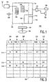
- FIG. 1 schematically shows some of the elements of a system according to the invention.
- the system 100 comprises a central unit 102 which controls the operation of the system and which includes various modules for performing specific tasks.
- the central unit can be implemented on a computer comprising a central processor and working memory loaded with software programs for carrying out the specific tasks.
- the system 100 has read means 104 to read information from a map database stored on a data carrier, like CD-ROM 106. Other types of carrier can also be used, e.g. magnetic disk and IC Card.
- the map database comprises information on roads of the area to which the particular map relates, e.g. the roads of a country or of a state. In the map database, a chain is used to represent a road element identifying an elementary part of a road.
- Chains are used to represent the road in a discrete way.
- Examples of road elements are: a part of the road between two junctions, a part of the road with a certain direction, a part of the road with a certain name, and a part of the road at an intersection.
- the map database has nodes, representing the begin and end points of a road element. So a chain terminates at a node and a next chain starts at that node, thus forming a network of routes.
- a node may be a junction between roads, so more than two chains are connected to that node, or may be an intermediate point where two chains are connected.
- the system 100 is equipped with an interface 108 suitable for receiving information concerning the current position of the vehicle in which the system is employed.
- This information can be supplied by a position determining system like a GPS receiver, using information broadcast by dedicated satellites.
- the position information can also be determined in another way, for instance using a locating system with one or more distance sensors, for measuring the distance travelled by the vehicle, and a compass, for measuring the heading of the vehicle.
- the system 100 further comprises a planning module 110 that is suitable to plan a route between an origin, e.g. the current position of the vehicle, and a desired destination.
- the desired destination is entered into the system in a convenient way, e.g. by entering the post code via a keyboard, by entering road names, by entering coordinates or by pointing to a position on a map displayed by the system.
- the planning module 110 searches through the map database for a route that is optimal according to some criterion.
- the planning module creates a large number of possible routes, each comprising a number of road elements, between the origin and the desired destination.
- the criterion can be the travel time, the travel distance, a combination of time and distance, or some other criterion that can be derived from information in the map database.
- the resulting route, comprising a number of selected chains, is stored in memory space 112 and the driver of the vehicle is given guidance to follow this route.
- the system comprises a guidance module 114 and an interface 116 for sending the guidance information to display 118 and/or loudspeaker 120.
- the system 100 may further comprise a display module 122 to display the chains of a section of the map on display 118. This section is displayed in a suitable scale and may indicate the planned route, the current position of the vehicle and the destination.
- the system 100 comprises a receiver 124 for the reception of traffic messages.
- the traffic message is interpreted by the system and information from the message, like the event and the problem location, may be stored in list 126.
- the planning module 110 may be arranged to search only a limited selection of the chains in the database when planning a route between the origin and the destination.
- a limitation of the number of chains to be taken into account results in a considerable saving of computational effort and time required to plan a route.
- the justification for the limitation is that roads far away from the origin and destination will probably never be part of the optimal route and can therefore be safely discarded by the planning module.
- the planning module then only searches for chains in the so-called search area, which is an area including the origin and the destination and which is formed on the basis of heuristic rules.
- the storage medium 106 may include an identification of a problem location to which a chain relates.
- the system is arranged to create a list 128 for these identifications relating to the chains in the search area.
- the system may be arranged to create a sub-list 130 of the identifications that relate to chains that are part of the planned route.
- the system can consult the list 128 to verify whether this particular problem location relates to a chain that is within the search area, i.e. has been considered by the planning module while creating the planned route. If the chain relating to the particular problem location is outside the search area, the message relates to an event that is not relevant for the planned route and may safely be discarded. If the chain relating to the particular problem location is inside the search area, the system must interpret the message and it may be necessary to re-plan a route to the destination now taking into account the circumstances indicated in the traffic message. The following situations can occur:
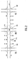
- Figure 2 shows an example of problem locations and interconnecting chains.
- An authority of a state or a country determines which locations on the roads for which it is responsible qualify as locations for which it must be possible to broadcast an event in a traffic message. These locations are called problem locations and are given a unique problem location number to identify them in the traffic message. Furthermore, the problem locations are ordered with respect to a pre-defined direction of travelling, by specifying for a problem location a previous problem location and a next problem location.
- the example shows a problem location 202, with problem location number 75, a problem location 204, with problem location number 80, and a problem location 206, with problem location number 15.
- Roads are represented in the database of the system by a series of chains, each having an identification, e.g.
- chain 208 has identification c2.
- the roads between the problem locations have different lanes for the different directions of travelling and this is represented by a different series of chains for each direction.
- the series c1-c2-c3 is used to travel from problem location 202 to problem location 204
- the series c7-c8-c9 is used to travel from problem location 204 to problem location 202.
- a problem location may indicate a certain relatively small region instead of a single point position.
- a junction of highways may be in the form of a clover leaf with various exits and fly-overs and still be identified as a single problem location. Then the chains of such a junction are considered as part of the problem location and not as road elements between problem locations.
- chains c20, c21 and c22 are within the region 210 of problem location 204 and are considered internal chains of that problem location.
- the database of the system contains information about a chain, like its start and end node, its direction, its name and many more items. This information is exploited by the system in various ways, e.g. for route planning and for drawing a map on the display.
- the storage medium contains additional information for a chain indicating to what problem location this chain leads.
- chain 208 leads to problem location 204 and this is represented by the additional chain information 212.
- the information present in the database which information is related to the chains, can be linked to the information received in the traffic messages, which information is related to problem location numbers.
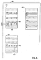
- Figure 3 shows an example of identifications of chains for given problem locations.
- the storage medium comprises information on the pre-defined problem locations. This can be in the form of a table 302, wherein a column represents a certain type of information about the problem location and a row corresponds to a record with the various fields of information for a given problem location.
- the example shows the following type of information:
- Figure 4 shows an example of additional chain information for 2-directional chains.
- a chain in the database has a node A and a node B, wherein by definition the x-co-ordinate of the node A is the smallest of the two nodes.
- An example is chain 402 with node 401 as its node A and with node 403 as its node B.
- the additional chain information comprises three items: the number of the problem location to which the chain leads, an indication whether the direction to reach that problem location is positive or negative, and the node in the direction of the referred problem location.
- chain 402 has additional chain information 404 comprising '20+B'.
- chain 402 leads towards problem location number 20, which is in the direction defined as positive and that this is in the direction of the node B of the chain. Since chain 402 can be travelled in two directions, there is another additional information item 406 for this chain comprising '10-A'. This means that chain 402 leads, if travelled in the reverse direction, to problem location 10, in the negative direction towards node A of the chain.
- Figure 5 shows an example of additional chain information for 1-directional chains. Now there are different chains for the different directions of travelling, e.g. the different lanes on a highway, and each chain has one additional information item, e.g. item 502 of chain 504.
- FIG. 6 shows the organisation of the information on the storage medium.
- the storage medium 600 has a first storage unit 602 comprising the information of the chains and nodes.
- the first storage unit 602 is divided into blocks each corresponding to a rectangular area of the map.
- a block in that embodiment has a maximum size of 16 Kbytes and the size of the covered rectangular area depends on the amount of road information in that area.
- the storage medium has a second storage unit 604 comprising the additional chain information. If a chain has such additional chain information there is an entry for that chain in the second storage unit.
- the additional chain information includes the identification of a problem location to which the chain leads. For example chain 402, with identification c100, has additional chain information 404 including the first identification 606 of the related problem location.
- a second additional information item 406 including a second identification 608 of the problem location to which the chain leads when travelled in the other direction.
- the structure of the first storage unit 602 remains unchanged, despite the addition of the identifications.
- An advantage is that the basic map information remains the same and that no new division into rectangular areas is required, which could be necessary if the identifications of the problem location would be stored directly with the chains in the first storage unit.
- a further advantage is that a later version of the storage medium including the identifications of problem locations is compatible with the previous version of the storage medium without the identifications, as far as the first storage unit with the chains and nodes is concerned. This means that a previous version of the navigation system, i.e. a version which is not designed to read the identification of the problem location, is still able to read the later version of the storage medium.
- the storage medium may further comprise a storage unit like table 302, that provides the identification of the chains connected to given problem location.
- a storage unit like table 302, that provides the identification of the chains connected to given problem location.
- a second identification 612 is stored, this one identifying a chain connected to the problem location and leading away from it in the negative direction.
- This storage unit is also separate from the first storage unit, so as to not change the structure of the first storage unit.
- the second storage unit 604 and the table 302 both provide a mechanism for integrating the information received in a traffic message with the information available in the database of the navigation system. These mechanisms function independently from each other and one may be present on the storage medium without requiring the presence of the other.
Landscapes
- Engineering & Computer Science (AREA)
- Radar, Positioning & Navigation (AREA)
- Remote Sensing (AREA)
- Physics & Mathematics (AREA)
- General Physics & Mathematics (AREA)
- Mathematical Physics (AREA)
- Automation & Control Theory (AREA)
- Navigation (AREA)
- Traffic Control Systems (AREA)
Abstract
Claims (13)
- Système de navigation (100) permettant de guider le conducteur d'un véhicule, le système comprenant :caractérisé en ce que les moyens de lecture (104) sont organisés afin de lire, à partir du support de stockage (302), des informations supplémentaires indiquant vers quel lieu à problème une chaíne particulière conduit ou quelle chaíne particulière est reliée à un lieu à problème.des moyens de lecture (104) permettant de lire des informations de chaíne à partir d'un support de stockage (106) comprenant une première unité de stockage avec les chaínes et les noeuds, une chaíne représentant un tronçon de route et étant reliée à une autre chaíne par l'intermédiaire d'un noeud,des moyens de traitement (110) permettant d'exploiter lesdites informations de chaíne, par exemple un module de préparation permettant de préparer un itinéraire ou un module d'affichage permettant d'afficher une carte sur un affichage, etun récepteur (24) permettant de recevoir un message de trafic qui se rapporte à un lieu à problème prédéfini ;
- Système de navigation (100) selon la revendication 1, dans lequel les moyens de lecture (104) sont organisés afin de lire, à partir du support de stockage, les informations supplémentaires d'une chaíne particulière (208) en rapport avec un noeud particulier correspondant à un lieu à problème (202), les informations supplémentaires comprenant une identification de ce lieu à problème.
- Système de navigation (100) selon la revendication 2, le système comprenant un module de préparation (100) permettant de préparer un itinéraire entre une origine et une destination, dans lequel le module de préparation est organisé afin de tenir compte des chaínes particulières qui font partie d'un secteur prédéterminé de recherche, le système étant organisé afin de créer une liste (128) contenant les identifications des lieux à problème en rapport avec les chaínes particulières du secteur de recherche, dans la mesure où elles sont présentes.
- Système de navigation (100) selon la revendication 3, le système étant organisé afin de créer une sous-liste contenant les identifications des lieux à problème en rapport avec les chaínes particulières de l'itinéraire prévu, dans la mesure où elles sont présentes.
- Système de navigation (100) selon la revendication 2, dans lequel les moyens de lecture (104) sont organisés afin de lire les informations supplémentaires de chaíne à partir d'une seconde unité de stockage (604) du support de stockage (600).
- Système de navigation (100) selon la revendication 1, dans lequel les moyens de lecture sont organisés afin de lire, à partir du support de stockage (106), les informations supplémentaires (302) du lieu à problème (314) en rapport avec le message de trafic, les informations supplémentaires (302) comprenant une première identification d'une première (310) des chaínes reliée à un noeud particulier correspondant au lieu à problème.
- Système de navigation (100) selon la revendication 6, dans lequel les moyens de lecture (104) sont organisés afin de lire, à partir du support de stockage (106), pour le lieu à problème en rapport avec le message de trafic, une deuxième identification d'une seconde (312) des chaínes reliée à un noeud particulier correspondant au lieu à problème, la seconde chaíne s'étendant dans une direction opposée à la première.
- Support de stockage (600) destiné à être utilisé dans un système de navigation, le support de stockage comprenant une première unité de stockage (602) avec des chaínes et des noeuds, une chaíne représentant un tronçon de route et étant reliée à une autre chaíne par l'intermédiaire d'un noeud, caractérisé en ce que le support de stockage (600) comprend des informations supplémentaires (302) indiquant vers quel lieu à problème une chaíne particulière conduit ou quelle chaíne particulière est reliée à un lieu à problème.
- Support de stockage (600) selon la réclamation 8, dans lequel les informations supplémentaires comprennent, pour une chaíne particulière, une première identification d'un premier lieu à problème, lequel premier lieu à problème correspond à un noeud particulier en rapport avec la chaíne particulière.
- Support de stockage (600) selon la revendication 9, dans lequel les informations supplémentaires (302) comprennent, pour la chaíne particulière, une seconde identification d'un second lieu à problème, lequel second lieu à problème correspond à un noeud particulier en rapport avec la chaíne particulière et concerne la direction de trajet opposée par rapport au premier lieu à problème.
- Support de stockage (600) selon la revendication 9, le support de stockage (600) comprenant une seconde unité de stockage (604) comprenant la première identification.
- Support de stockage (600) selon la revendication 8, dans lequel les informations supplémentaires (302) comprennent, pour un lieu à problème prédéfini particulier (314), une première identification (310) d'une première des chaínes, laquelle chaíne est reliée au noeud correspondant prédéfini du lieu à problème.
- Support de stockage (600) selon la revendication 12, dans lequel les informations supplémentaires (302) comprennent, pour le lieu à problème particulier, une seconde identification (312) d'une seconde des chaínes, laquelle seconde des chaínes est reliée au noeud correspondant prédéfini du lieu à problème et laquelle seconde des chaínes concerne une direction de trajet opposée à la première.
Priority Applications (1)
| Application Number | Priority Date | Filing Date | Title |
|---|---|---|---|
| EP98921689A EP0922201B1 (fr) | 1997-07-01 | 1998-06-05 | Systeme de navigation a utiliser dans un vehicule |
Applications Claiming Priority (4)
| Application Number | Priority Date | Filing Date | Title |
|---|---|---|---|
| EP97202003 | 1997-07-01 | ||
| EP97202003 | 1997-07-01 | ||
| PCT/IB1998/000882 WO1999001017A2 (fr) | 1997-07-01 | 1998-06-05 | Systeme de navigation a utiliser dans un vehicule |
| EP98921689A EP0922201B1 (fr) | 1997-07-01 | 1998-06-05 | Systeme de navigation a utiliser dans un vehicule |
Publications (2)
| Publication Number | Publication Date |
|---|---|
| EP0922201A2 EP0922201A2 (fr) | 1999-06-16 |
| EP0922201B1 true EP0922201B1 (fr) | 2002-09-11 |
Family
ID=8228504
Family Applications (1)
| Application Number | Title | Priority Date | Filing Date |
|---|---|---|---|
| EP98921689A Expired - Lifetime EP0922201B1 (fr) | 1997-07-01 | 1998-06-05 | Systeme de navigation a utiliser dans un vehicule |
Country Status (5)
| Country | Link |
|---|---|
| US (1) | US6298302B2 (fr) |
| EP (1) | EP0922201B1 (fr) |
| JP (1) | JP4121157B2 (fr) |
| DE (1) | DE69807828T2 (fr) |
| WO (1) | WO1999001017A2 (fr) |
Families Citing this family (71)
| Publication number | Priority date | Publication date | Assignee | Title |
|---|---|---|---|---|
| US8352400B2 (en) | 1991-12-23 | 2013-01-08 | Hoffberg Steven M | Adaptive pattern recognition based controller apparatus and method and human-factored interface therefore |
| US10361802B1 (en) | 1999-02-01 | 2019-07-23 | Blanding Hovenweep, Llc | Adaptive pattern recognition based control system and method |
| US7912645B2 (en) * | 1997-10-22 | 2011-03-22 | Intelligent Technologies International, Inc. | Information transfer arrangement and method for vehicles |
| US7418346B2 (en) * | 1997-10-22 | 2008-08-26 | Intelligent Technologies International, Inc. | Collision avoidance methods and systems |
| US7629899B2 (en) * | 1997-10-22 | 2009-12-08 | Intelligent Technologies International, Inc. | Vehicular communication arrangement and method |
| US7110880B2 (en) * | 1997-10-22 | 2006-09-19 | Intelligent Technologies International, Inc. | Communication method and arrangement |
| US7426437B2 (en) * | 1997-10-22 | 2008-09-16 | Intelligent Technologies International, Inc. | Accident avoidance systems and methods |
| US8255144B2 (en) * | 1997-10-22 | 2012-08-28 | Intelligent Technologies International, Inc. | Intra-vehicle information conveyance system and method |
| US8965677B2 (en) | 1998-10-22 | 2015-02-24 | Intelligent Technologies International, Inc. | Intra-vehicle information conveyance system and method |
| US7904187B2 (en) | 1999-02-01 | 2011-03-08 | Hoffberg Steven M | Internet appliance system and method |
| DE19947790A1 (de) * | 1999-10-05 | 2001-04-12 | Mannesmann Vdo Ag | Navigationssystem mit automatischem Datenträgerwechsel |
| JP2002152067A (ja) * | 2000-11-08 | 2002-05-24 | Nissan Motor Co Ltd | 番組自動構成装置 |
| US6804524B1 (en) * | 2000-11-21 | 2004-10-12 | Openwave Systems Inc. | System and method for the acquisition of automobile traffic data through wireless networks |
| US6898432B1 (en) * | 2000-11-21 | 2005-05-24 | Daimlerchrysler Research And Technology North America, Inc. | Route-based communication planning architecture and method for wireless communication |
| US10298735B2 (en) | 2001-04-24 | 2019-05-21 | Northwater Intellectual Property Fund L.P. 2 | Method and apparatus for dynamic configuration of a multiprocessor health data system |
| US7146260B2 (en) | 2001-04-24 | 2006-12-05 | Medius, Inc. | Method and apparatus for dynamic configuration of multiprocessor system |
| US6792351B2 (en) * | 2001-06-26 | 2004-09-14 | Medius, Inc. | Method and apparatus for multi-vehicle communication |
| JP2003016339A (ja) * | 2001-06-28 | 2003-01-17 | Pioneer Electronic Corp | 情報配信装置及びシステム並びに方法 |
| US20050113113A1 (en) * | 2001-11-15 | 2005-05-26 | Reed Mark J. | Enhanced wireless phone |
| US7221287B2 (en) | 2002-03-05 | 2007-05-22 | Triangle Software Llc | Three-dimensional traffic report |
| US7178049B2 (en) | 2002-04-24 | 2007-02-13 | Medius, Inc. | Method for multi-tasking multiple Java virtual machines in a secure environment |
| US6963800B1 (en) | 2002-05-10 | 2005-11-08 | Solider Vision | Routing soldiers around enemy attacks and battlefield obstructions |
| JP3937939B2 (ja) * | 2002-06-14 | 2007-06-27 | アイシン・エィ・ダブリュ株式会社 | ナビゲーションシステム及び経路案内データ記録方法のプログラム |
| US7027915B2 (en) * | 2002-10-09 | 2006-04-11 | Craine Dean A | Personal traffic congestion avoidance system |
| US7756635B2 (en) * | 2003-04-09 | 2010-07-13 | Primordial, Inc. | Method and system for generating and presenting off-road travel routes |
| WO2005013063A2 (fr) | 2003-07-25 | 2005-02-10 | Landsonar, Inc. | Systeme et procede pour determiner une heure de depart recommandee |
| US7050903B1 (en) * | 2003-09-23 | 2006-05-23 | Navteq North America, Llc | Method and system for developing traffic messages |
| US7319931B2 (en) * | 2004-04-06 | 2008-01-15 | Honda Motor Co., Ltd. | Methods for filtering and providing traffic information |
| US7222018B2 (en) | 2004-04-06 | 2007-05-22 | Honda Motor Co., Ltd. | Bandwidth and memory conserving methods for a vehicle navigation system |
| US7289904B2 (en) | 2004-04-06 | 2007-10-30 | Honda Motor Co., Ltd. | Vehicle navigation system and methods for incorporating user preferences into same |
| US7366606B2 (en) | 2004-04-06 | 2008-04-29 | Honda Motor Co., Ltd. | Method for refining traffic flow data |
| US7337650B1 (en) | 2004-11-09 | 2008-03-04 | Medius Inc. | System and method for aligning sensors on a vehicle |
| DE102005012269B4 (de) * | 2005-03-17 | 2013-05-16 | Robert Bosch Gmbh | Verfahren und Anordnung zur Führung eines Fahrzeugs sowie ein entsprechendes Computerprogramm und ein entsprechendes computerlesbares Speichermedium |
| US20060212507A1 (en) * | 2005-03-18 | 2006-09-21 | Clark Darren L | Location-based historical performance information for entertainment devices |
| US20060247852A1 (en) * | 2005-04-29 | 2006-11-02 | Kortge James M | System and method for providing safety-optimized navigation route planning |
| US20070179702A1 (en) * | 2006-01-27 | 2007-08-02 | Garmin Ltd., A Cayman Islands Corporation | Combined receiver and power adapter |
| US7610151B2 (en) | 2006-06-27 | 2009-10-27 | Microsoft Corporation | Collaborative route planning for generating personalized and context-sensitive routing recommendations |
| US8793066B2 (en) | 2006-06-27 | 2014-07-29 | Microsoft Corporation | Route monetization |
| US7706964B2 (en) * | 2006-06-30 | 2010-04-27 | Microsoft Corporation | Inferring road speeds for context-sensitive routing |
| US8126641B2 (en) * | 2006-06-30 | 2012-02-28 | Microsoft Corporation | Route planning with contingencies |
| US7739040B2 (en) | 2006-06-30 | 2010-06-15 | Microsoft Corporation | Computation of travel routes, durations, and plans over multiple contexts |
| US7617042B2 (en) | 2006-06-30 | 2009-11-10 | Microsoft Corporation | Computing and harnessing inferences about the timing, duration, and nature of motion and cessation of motion with applications to mobile computing and communications |
| US7668653B2 (en) | 2007-05-31 | 2010-02-23 | Honda Motor Co., Ltd. | System and method for selectively filtering and providing event program information |
| US9852624B2 (en) | 2007-09-07 | 2017-12-26 | Connected Signals, Inc. | Network security system with application for driver safety system |
| US20110037619A1 (en) * | 2009-08-11 | 2011-02-17 | On Time Systems, Inc. | Traffic Routing Using Intelligent Traffic Signals, GPS and Mobile Data Devices |
| US10083607B2 (en) | 2007-09-07 | 2018-09-25 | Green Driver, Inc. | Driver safety enhancement using intelligent traffic signals and GPS |
| US9043138B2 (en) * | 2007-09-07 | 2015-05-26 | Green Driver, Inc. | System and method for automated updating of map information |
| US8442477B2 (en) * | 2007-11-09 | 2013-05-14 | Garmin Switzerland Gmbh | Traffic receiver and power adapter for portable navigation devices |
| US20090157540A1 (en) * | 2007-12-14 | 2009-06-18 | Microsoft Corporation | Destination auctioned through business of interest |
| US20090157498A1 (en) * | 2007-12-14 | 2009-06-18 | Microsoft Corporation | Generational intelligent navigation synchronization or update |
| US20090210302A1 (en) * | 2008-02-19 | 2009-08-20 | Microsoft Corporation | Route reward augmentation |
| US20090210242A1 (en) * | 2008-02-19 | 2009-08-20 | Microsoft Corporation | Load balance payment |
| US20090210142A1 (en) * | 2008-02-19 | 2009-08-20 | Microsoft Corporation | Safe route configuration |
| WO2010005424A1 (fr) | 2008-07-07 | 2010-01-14 | Primordial, Inc. | Système et procédé de génération de trajets tactiques |
| US9046924B2 (en) | 2009-03-04 | 2015-06-02 | Pelmorex Canada Inc. | Gesture based interaction with traffic data |
| US8619072B2 (en) | 2009-03-04 | 2013-12-31 | Triangle Software Llc | Controlling a three-dimensional virtual broadcast presentation |
| US8982116B2 (en) | 2009-03-04 | 2015-03-17 | Pelmorex Canada Inc. | Touch screen based interaction with traffic data |
| US9358924B1 (en) | 2009-05-08 | 2016-06-07 | Eagle Harbor Holdings, Llc | System and method for modeling advanced automotive safety systems |
| US8417490B1 (en) | 2009-05-11 | 2013-04-09 | Eagle Harbor Holdings, Llc | System and method for the configuration of an automotive vehicle with modeled sensors |
| US10198942B2 (en) | 2009-08-11 | 2019-02-05 | Connected Signals, Inc. | Traffic routing display system with multiple signal lookahead |
| JP5535711B2 (ja) * | 2010-03-24 | 2014-07-02 | アルパイン株式会社 | 車載用ナビゲーション装置及び交通情報表示方法 |
| WO2012065188A2 (fr) | 2010-11-14 | 2012-05-18 | Triangle Software Llc | Rapport de trafic d'externalisation à grande échelle |
| US8412445B2 (en) * | 2011-02-18 | 2013-04-02 | Honda Motor Co., Ltd | Predictive routing system and method |
| CA2839866C (fr) | 2011-05-18 | 2021-04-13 | Triangle Software Llc | Systeme permettant d'utiliser des donnees de trafic et des donnees d'efficacite de conduite |
| US8886392B1 (en) | 2011-12-21 | 2014-11-11 | Intellectual Ventures Fund 79 Llc | Methods, devices, and mediums associated with managing vehicle maintenance activities |
| US8781718B2 (en) | 2012-01-27 | 2014-07-15 | Pelmorex Canada Inc. | Estimating time travel distributions on signalized arterials |
| US10223909B2 (en) | 2012-10-18 | 2019-03-05 | Uber Technologies, Inc. | Estimating time travel distributions on signalized arterials |
| US9053636B2 (en) | 2012-12-30 | 2015-06-09 | Robert Gordon | Management center module for advanced lane management assist for automated vehicles and conventionally driven vehicles |
| US9286800B2 (en) | 2012-12-30 | 2016-03-15 | Robert Gordon | Guidance assist vehicle module |
| US9799218B1 (en) | 2016-05-09 | 2017-10-24 | Robert Gordon | Prediction for lane guidance assist |
| US9911329B1 (en) | 2017-02-23 | 2018-03-06 | Robert Gordon | Enhanced traffic sign information messaging system |
Family Cites Families (21)
| Publication number | Priority date | Publication date | Assignee | Title |
|---|---|---|---|---|
| DE3752122T3 (de) * | 1987-05-09 | 2004-07-29 | Koninklijke Philips Electronics N.V. | Einrichtung für Empfang und Verarbeitung von Strassennachrichtenmeldungen |
| DE3810177C2 (de) * | 1988-03-25 | 1999-06-17 | Bosch Gmbh Robert | Rundfunkempfänger, insbesondere Fahrzeugempfänger |
| US5193214A (en) * | 1989-12-29 | 1993-03-09 | Robert Bosch Gmbh | Vehicular radio receiver with standard traffic problem database |
| US5428544A (en) * | 1990-11-05 | 1995-06-27 | Norm Pacific Automation Corporation | Traffic information inter-vehicle transference and navigation system |
| DE4208277A1 (de) * | 1992-03-13 | 1993-09-16 | Bosch Gmbh Robert | Verkehrsrundfunkempfaenger |
| FR2689667B1 (fr) * | 1992-04-01 | 1995-10-20 | Sagem | Recepteur de bord d'aide a la navigation d'un vehicule automobile. |
| JP2999339B2 (ja) * | 1993-01-11 | 2000-01-17 | 三菱電機株式会社 | 車両用経路案内装置 |
| JP3385657B2 (ja) * | 1993-08-10 | 2003-03-10 | トヨタ自動車株式会社 | 車載用ナビゲーション装置 |
| JP3045013B2 (ja) * | 1994-09-16 | 2000-05-22 | 住友電気工業株式会社 | ナビゲーション装置 |
| US5610821A (en) * | 1994-11-18 | 1997-03-11 | Ibm Corporation | Optimal and stable route planning system |
| US5850193A (en) * | 1995-03-30 | 1998-12-15 | Sumitomo Electric Industries, Ltd. | Apparatus for assisting driver in carefully driving |
| JP2826079B2 (ja) * | 1995-04-21 | 1998-11-18 | 株式会社ザナヴィ・インフォマティクス | 車載用地図データベース装置 |
| DE19516477A1 (de) * | 1995-05-05 | 1996-11-07 | Bosch Gmbh Robert | Einrichtung zur Aufbereitung und Ausgabe von Informationen für einen Fahrzeugführer |
| US5911773A (en) * | 1995-07-24 | 1999-06-15 | Aisin Aw Co., Ltd. | Navigation system for vehicles |
| DE19527188A1 (de) * | 1995-07-26 | 1997-01-30 | Philips Patentverwaltung | RDS-TMC-Rundfunkempfänger |
| DE19527187A1 (de) * | 1995-07-26 | 1997-01-30 | Philips Patentverwaltung | RDS-TMC-Rundfunkempfänger |
| JP3483672B2 (ja) * | 1995-09-06 | 2004-01-06 | 三菱電機株式会社 | ナビゲーション装置 |
| DE19538453A1 (de) * | 1995-10-16 | 1997-04-17 | Bayerische Motoren Werke Ag | Funksignalempfänger für Kraftfahrzeuge mit einem RDS-Dekoder für digitale Signale |
| KR100224326B1 (ko) * | 1995-12-26 | 1999-10-15 | 모리 하루오 | 차량용 네비게이션장치 |
| JPH1082647A (ja) * | 1996-09-05 | 1998-03-31 | Mitsubishi Electric Corp | 移動体用ナビゲーション装置 |
| JP3698835B2 (ja) * | 1996-10-25 | 2005-09-21 | 三菱電機株式会社 | 交通情報表示装置及びその表示方法並びに交通情報表示装置用表示制御プログラムを記録した媒体 |
-
1998
- 1998-06-05 WO PCT/IB1998/000882 patent/WO1999001017A2/fr active IP Right Grant
- 1998-06-05 JP JP50676999A patent/JP4121157B2/ja not_active Expired - Fee Related
- 1998-06-05 DE DE69807828T patent/DE69807828T2/de not_active Expired - Lifetime
- 1998-06-05 EP EP98921689A patent/EP0922201B1/fr not_active Expired - Lifetime
- 1998-06-30 US US09/107,530 patent/US6298302B2/en not_active Expired - Lifetime
Also Published As
| Publication number | Publication date |
|---|---|
| EP0922201A2 (fr) | 1999-06-16 |
| JP4121157B2 (ja) | 2008-07-23 |
| DE69807828T2 (de) | 2003-02-20 |
| JP2001506390A (ja) | 2001-05-15 |
| WO1999001017A2 (fr) | 1999-01-14 |
| WO1999001017A3 (fr) | 1999-04-01 |
| US6298302B2 (en) | 2001-10-02 |
| DE69807828D1 (de) | 2002-10-17 |
| US20010014848A1 (en) | 2001-08-16 |
Similar Documents
| Publication | Publication Date | Title |
|---|---|---|
| EP0922201B1 (fr) | Systeme de navigation a utiliser dans un vehicule | |
| EP0886846B1 (fr) | Procede pour guider le conducteur d'un vehicule et systeme de navigation pour la realisation de ce procede | |
| US7257484B2 (en) | Method for searching car navigation path by using log file | |
| EP1589511B1 (fr) | Appareil et procédé pour le traitement d'informations routières | |
| JP4148580B2 (ja) | ナビゲーションシステムと共に実時間交通情報放送を使用する方法及びシステム | |
| EP0833291B2 (fr) | Appareil de navigation pour véhicule et moyen de mémorisation | |
| EP0689034B1 (fr) | Méthode d'identification des bretelles d'accès d'autoroute servant au calcul de route dans un système de navigation véhiculaire | |
| US8634984B2 (en) | Navigation system | |
| US6269303B1 (en) | Vehicle navigation system and recording medium | |
| US6226590B1 (en) | Vehicular navigation system and storage medium | |
| US20020129020A1 (en) | Map database apparatus | |
| GB2306738A (en) | Vehicle guidance as a function of the traffic situation | |
| EP0664007B1 (fr) | Systeme de navigation pour vehicule | |
| US20090234572A1 (en) | Surrounding Search Data Generating System, Surrounding Search System, Surrounding Search Data Generating Method, Surrounding Search Method, and Navigation Apparatus | |
| US5974357A (en) | Sign text display for vehicle navigation system | |
| US7219010B2 (en) | Vehicle navigation apparatus and a program for controlling vehicle navigation apparatus | |
| JPH11304517A (ja) | 経路探索装置 | |
| JP3732008B2 (ja) | ナビゲーション装置 | |
| US6216085B1 (en) | Navigation system for a vehicle | |
| JP3511902B2 (ja) | 経路情報提供装置、経路案内装置および通信型ナビゲーションシステム | |
| US20100145604A1 (en) | Navigation device and navigation road data creating device | |
| JPH11161157A (ja) | 地図データ処理装置 | |
| JPH0715386B2 (ja) | 車載ナビゲーション装置 | |
| KR19990058326A (ko) | 차량항법장치의 경로안내장치 | |
| JPH11304515A (ja) | 経路探索装置 |
Legal Events
| Date | Code | Title | Description |
|---|---|---|---|
| PUAI | Public reference made under article 153(3) epc to a published international application that has entered the european phase |
Free format text: ORIGINAL CODE: 0009012 |
|
| 17P | Request for examination filed |
Effective date: 19990401 |
|
| AK | Designated contracting states |
Kind code of ref document: A2 Designated state(s): DE FR GB |
|
| 17Q | First examination report despatched |
Effective date: 20001023 |
|
| GRAG | Despatch of communication of intention to grant |
Free format text: ORIGINAL CODE: EPIDOS AGRA |
|
| GRAG | Despatch of communication of intention to grant |
Free format text: ORIGINAL CODE: EPIDOS AGRA |
|
| GRAH | Despatch of communication of intention to grant a patent |
Free format text: ORIGINAL CODE: EPIDOS IGRA |
|
| RAP1 | Party data changed (applicant data changed or rights of an application transferred) |
Owner name: SIEMENS AKTIENGESELLSCHAFT |
|
| GRAH | Despatch of communication of intention to grant a patent |
Free format text: ORIGINAL CODE: EPIDOS IGRA |
|
| GRAA | (expected) grant |
Free format text: ORIGINAL CODE: 0009210 |
|
| AK | Designated contracting states |
Kind code of ref document: B1 Designated state(s): DE FR GB |
|
| REG | Reference to a national code |
Ref country code: GB Ref legal event code: FG4D |
|
| REF | Corresponds to: |
Ref document number: 69807828 Country of ref document: DE Date of ref document: 20021017 |
|
| ET | Fr: translation filed | ||
| PLBE | No opposition filed within time limit |
Free format text: ORIGINAL CODE: 0009261 |
|
| STAA | Information on the status of an ep patent application or granted ep patent |
Free format text: STATUS: NO OPPOSITION FILED WITHIN TIME LIMIT |
|
| 26N | No opposition filed |
Effective date: 20030612 |
|
| REG | Reference to a national code |
Ref country code: FR Ref legal event code: TP |
|
| REG | Reference to a national code |
Ref country code: GB Ref legal event code: 732E Free format text: REGISTERED BETWEEN 20110825 AND 20110831 |
|
| PGFP | Annual fee paid to national office [announced via postgrant information from national office to epo] |
Ref country code: GB Payment date: 20120622 Year of fee payment: 15 |
|
| GBPC | Gb: european patent ceased through non-payment of renewal fee |
Effective date: 20130605 |
|
| PG25 | Lapsed in a contracting state [announced via postgrant information from national office to epo] |
Ref country code: GB Free format text: LAPSE BECAUSE OF NON-PAYMENT OF DUE FEES Effective date: 20130605 |
|
| PGFP | Annual fee paid to national office [announced via postgrant information from national office to epo] |
Ref country code: FR Payment date: 20140619 Year of fee payment: 17 |
|
| REG | Reference to a national code |
Ref country code: DE Ref legal event code: R084 Ref document number: 69807828 Country of ref document: DE |
|
| REG | Reference to a national code |
Ref country code: DE Ref legal event code: R084 Ref document number: 69807828 Country of ref document: DE Effective date: 20150323 |
|
| REG | Reference to a national code |
Ref country code: FR Ref legal event code: ST Effective date: 20160229 |
|
| PG25 | Lapsed in a contracting state [announced via postgrant information from national office to epo] |
Ref country code: FR Free format text: LAPSE BECAUSE OF NON-PAYMENT OF DUE FEES Effective date: 20150630 |
|
| PGFP | Annual fee paid to national office [announced via postgrant information from national office to epo] |
Ref country code: DE Payment date: 20170630 Year of fee payment: 20 |
|
| REG | Reference to a national code |
Ref country code: DE Ref legal event code: R071 Ref document number: 69807828 Country of ref document: DE |