EP0664007B1 - Systeme de navigation pour vehicule - Google Patents
Systeme de navigation pour vehicule Download PDFInfo
- Publication number
- EP0664007B1 EP0664007B1 EP93922017A EP93922017A EP0664007B1 EP 0664007 B1 EP0664007 B1 EP 0664007B1 EP 93922017 A EP93922017 A EP 93922017A EP 93922017 A EP93922017 A EP 93922017A EP 0664007 B1 EP0664007 B1 EP 0664007B1
- Authority
- EP
- European Patent Office
- Prior art keywords
- vehicle
- links
- stored
- data
- nodes
- Prior art date
- Legal status (The legal status is an assumption and is not a legal conclusion. Google has not performed a legal analysis and makes no representation as to the accuracy of the status listed.)
- Expired - Lifetime
Links
Images
Classifications
-
- G—PHYSICS
- G01—MEASURING; TESTING
- G01C—MEASURING DISTANCES, LEVELS OR BEARINGS; SURVEYING; NAVIGATION; GYROSCOPIC INSTRUMENTS; PHOTOGRAMMETRY OR VIDEOGRAMMETRY
- G01C21/00—Navigation; Navigational instruments not provided for in groups G01C1/00 - G01C19/00
- G01C21/26—Navigation; Navigational instruments not provided for in groups G01C1/00 - G01C19/00 specially adapted for navigation in a road network
- G01C21/34—Route searching; Route guidance
- G01C21/3453—Special cost functions, i.e. other than distance or default speed limit of road segments
- G01C21/3492—Special cost functions, i.e. other than distance or default speed limit of road segments employing speed data or traffic data, e.g. real-time or historical
-
- G—PHYSICS
- G08—SIGNALLING
- G08G—TRAFFIC CONTROL SYSTEMS
- G08G1/00—Traffic control systems for road vehicles
- G08G1/09—Arrangements for giving variable traffic instructions
- G08G1/0962—Arrangements for giving variable traffic instructions having an indicator mounted inside the vehicle, e.g. giving voice messages
- G08G1/0968—Systems involving transmission of navigation instructions to the vehicle
- G08G1/0969—Systems involving transmission of navigation instructions to the vehicle having a display in the form of a map
Definitions
- the present invention relates to a navigation system for a motor vehicle.
- RDS-TMC systems which assist drivers to avoid bottlenecks by transmitting a digital message over a radio channel to the driver to warn of traffic jams.
- EP 0 478 438 The closest prior art known to the Applicants is EP 0 478 438.
- This patent describes the use of RDS-TMC in conjunction with signal from a satellite global positioning system (GPS), odometer and compass measurements and a map database, and is similar to the present application in these respects.
- GPS global positioning system
- this reference relies on the use of a raster map and employs colour overlays on this map to highlight problems reported by RDS-TMC.
- a raster map is one stored in memory as a series of colour pixels, which, when presented on a screen, provides, a colour picture similar to a printed map. There is no way of cross-relating the position of a vehicle to the roads drawn on the map, and the memory storage requirements are high.
- differential GPS an accurate version of GPS called differential GPS is used in the patent, where corrections are broadcast to the vehicle from a fixed site.
- the compass and odometer are used to track the vehicle's progress across the map picture.
- EP-A-0 323 229 describes a route searching system of a navigation apparatus, which relies on the use of a vector map to provide the driver with navigational guidance.
- the vector map employed to enable accurate route guidance to be given to the driver records the position of the centreline of each road over its entire length to allow progress of the vehicle to be monitored. At each node or road intersection, each combination of entry and exit point is recorded as a different vector and once again the complexity of the system is such as to require large amounts of memory.
- Route planning systems have also been developed that require less storage of data.
- the intersections between roads constitute nodes and the data stored is made up of nodes, having known coordinates, and links connecting the nodes.
- Data is stored for each link to enable routes to be selected so that the length, average speed, type of road (e.g. motorway, dual carriage way etc), weight limit, height limit or width limit may be stored in addition to the nodes connected by the link, but no attempt is made to define map coordinates for each point on a link.
- the present invention seeks to provide an improved navigation system which combines the advantages of the individual systems mentioned above while minimising the hardware requirements for data storage and processing.
- the present invention relies on a very simple map database that is carried in the vehicle.
- This is a vector map, so called because it consists of nodes at junctions whose coordinates are known, connected by vectors of unspecified shape which connect the nodes and define attributes such as the actual road distance and typical drive times together with constraints such as banned turns and width and weight restrictions.
- the present invention therefore differs from EP 0 478 438 by the fact that it is sufficiently inexpensive and robust to find practical application in a vehicle environment, which is not well suited to disk based memories, be they CD-ROM or hard disk.
- the invention does not seek to indicate to the driver his position on a map. Apart from being complex to achieve, this does not provide the driver with the easiest of instructions. What the invention does provide is clear, preferably textual rather than graphic, instructions at each junction as to the direction by which the driver should leave the junction to arrive in the quickest time at his desired destination, even taking into consideration changing data such as traffic information.
- the navigation system includes means for detecting such deviation from the instructed route while working within the constraints imposed by the use of a limited vector map.
- the length of link is stored and the measured distance travelled after each node is subtracted from the length of the link.
- the remaining length of the link is then compared with the distance in a straight line between the current position of the vehicle and the position of the next node. If the distance in a straight line to the next node exceeds the remaining length of the link, then it is assumed that the incorrect route has been followed and a new route is determined connecting the current vehicle position to the desired destination.
- the database in this case carries the length of a road joining two junctions but does not know its shape.
- the GPS in the vehicle can calculate where the vehicle is at any time and the database carries the position of the next junction.
- the in-vehicle computer can therefore calculate the straight line distance between the GPS position and the position of the next junction and compare it with the length of the road link less the odometer distance already travelled from the previous junction. If this distance is less than the straight line distance at any time, allowing for tolerances, the vehicle must be off-route.
- a compass is not used, nor is the differential correction of GPS, the system being designed to accept the poorer tolerances of uncorrected GPS.
- the output means may be a voice synthesiser or a visual display.
- the system further comprises means for entering data into the system by the driver to indicate, for example, desired destination, current position, height limits etc.
- Such input means may be a keyboard, a light pen a mouse, tracker ball or the like input device.
- the information stored on links may preferably include expected times to traverse the entire length of the link under different traffic conditions, such as normal conditions, rush hours etc.
- traffic conditions such as normal conditions, rush hours etc.
- the driver may be routed through city centre if travelling at night but directed to follow a ring road if travelling during rush hours.
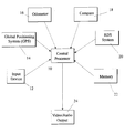
- central processor 10 is a programmed computer that may be based on an industry standard micro-computer, for example one based on an Intel 80386 processing chip.
- the RDS-TMC system 20 may be of known construction, and its function is to extract from a radio signal encoded traffic message information. This information is currently transmitted in digital form and includes information identifying the links affected by the traffic message as well as data identifying the extent of the delay.
- the GPS satellite navigation system 14 is also known per se but one may use other positioning systems to determine the absolute map coordinates of the vehicle, for example one may use a system relying on land beacons.
- the data is not continuously available and the purpose of the odometer 16 and compass 18 connected to the central processor 10 is to permit the position of the vehicle to be estimated by dead reckoning between readings from the GPS system.
- the central processor 10 connected to a memory 22 which contains both program information and navigation data, an output device for giving the driver directions either by displaying text on a screen or by using a voice synthesiser, and an input device 12 to allow the driver to communicate with the central processor, for example to indicate the desired destination.
- This may be a keyboard or more conveniently a pointing device such as a light pen or a tracker ball.
- the memory 22 stores data on nodes which correspond to road intersections and vectors connecting these nodes.
- vector is used to represent each link connecting two nodes but the information stored about these links does not provide map coordinates and a bearing for each point on the link but data indicating the length of the road and other scalar data such as the average road speed at different times of day, weight and width limits along the road and so on. From this information the processor can determine the combination of links that results in the shortest time between the origin and the desired destination.
- This data and the program for processing the data may be similar to those currently used on route planning programs that operate on a personal desktop computer.
- RDS-TMC messages are decoded from their RDS groups by the in-vehicle radio receiver 20, the coded messages being stored in a buffer until called by the vehicle navigation system.
- the processor 10 Whenever the processor 10 is not servicing other interrupts, it transfers these coded messages into a file, overwriting old copies of the same message, uses databases stored in memory to translate the messages and locations and cross-reference tables to convert the messages into changed travel times for the equivalent links in the route planner network which are then redefined.
- the TMC file is regularly updated to ensure that the message is still valid according to its duration.
- each link is also further modified by the time-of-day information according to a road type attribute. To adjust the link times according to the time of day, each road type attribute carries a set of times and related percentages of free-flow link speed. Once the planner has established when the link will be reached, the time for that link is interpolated from this information.
- the locations affected are checked against the links and nodes of the existing planned route. If any location matches, the converted message is announced to the screen and/or by the speech synthesiser 24. The effect on the link times is also calculated.
- the relative performance of the vehicle on the links it has covered are also used to adjust predicted times for future links and the route replanned.
- the processor 10 processes the stored data to modify the predicted speed along the links still remaining in dependence upon the deviation of the actual vehicle speed from the predicted vehicle speed along links already covered during the journey. If an alternative route is found which is a predetermined number of minutes better than the modified existing route, it is offered to the driver. The route is also recalculated every time the vehicle passes a node. An estimated time of arrival and remaining distance to the destination are continually updated.
- Route guidance instructions are stored as text and displayed and announced when the vehicle is first within a radial distance of the node determined by the class of road and speed of the vehicle. Where lines of text contain distance information, this is evaluated and the odometer input is used to announce these instructions at the appropriate position.
- the vehicle If the odometer reading since passing through a node exceeds the difference between the length of the node and distance in a straight line from the present position of the vehicle (as determined by the GPS system 14) to the next node, allowing for tolerance, or if a node is reached which does not lie on the planned route, the vehicle is declared to be "Off-Route". On acknowledgement by the driver, the driver is asked directed to the nearest node on the stored network and a new route is planned to the desired destination from that node.
Landscapes
- Engineering & Computer Science (AREA)
- Radar, Positioning & Navigation (AREA)
- Remote Sensing (AREA)
- Automation & Control Theory (AREA)
- Physics & Mathematics (AREA)
- General Physics & Mathematics (AREA)
- Navigation (AREA)
Abstract
Claims (6)
- Système de navigation de véhicule, comprenant un système de positionnement absolu (14) destiné à déterminer les coordonnées en cours du véhicule sur la carte, un moyen de mesure de distance et de direction (16, 18) destiné à permettre d'estimer la position réelle du véhicule lorsque les données obtenues à partir du système de positionnement absolu ne sont pas disponibles, un moyen de mémorisation (22) destiné à mémoriser les données cartographiques, un moyen (20) destiné à recevoir et à décoder des signaux émis sur un canal radio de messages de trafic, un moyen de traitement (10) destiné à calculer un itinéraire optimum entre la position actuelle du véhicule et la destination souhaitée, et un moyen de sortie (24) sous la commande du moyen de traitement (10) destiné à procurer un guidage de navigation au conducteur du véhicule, caractérisé en ce que les données cartographiques mémorisées dans le moyen de mémorisation (22) ne comprennent que des informations concernant les noeuds représentant des intersections de routes, et les liaisons reliant les noeuds, en ce que le moyen de traitement (10) peut être mis en oeuvre pour traiter les données mémorisées se rapportant aux liaisons entre les noeuds suivant les données du canal de messages de trafic, et en ce que le moyen de sortie (24) comprend un moyen destiné à indiquer au conducteur une direction de parcours recommandée à chaque intersection de route correspondant à un noeud mémorisé.
- Système selon la revendication 1, dans lequel les informations mémorisées concernant les liaisons comprennent les temps prévus pour parcourir la longueur entière de la liaison dans différentes conditions de trafic.
- Système de navigation selon la revendication 2, dans lequel le moyen de traitement (10) peut être en outre mis en oeuvre pour traiter les données mémorisées afin de modifier la vitesse moyenne suivant les liaisons en fonction de l'heure du jour.
- Système de navigation selon la revendication 2 ou 3, dans lequel le moyen de traitement (10) peut être en outre mis en oeuvre pour traiter les données mémorisées afin de modifier la vitesse prévue le long des liaisons en fonction de l'écart de la vitesse réelle du véhicule par rapport à la vitesse prévue du véhicule suivant les liaisons déjà couvertes pendant un voyage.
- Système selon la revendication 1, dans lequel le moyen de sortie (24) comprend un synthétiseur vocal et/ou un dispositif d'affichage visuel.
- Système selon la revendication 1, dans lequel la longueur de chaque liaison est mémorisée et le moyen de traitement (10) peut être mis en oeuvre pour soustraire la distance mesurée parcourue après chaque noeud, de la longueur de la liaison et de comparer la longueur restante de la liaison, à la distance en ligne droite entre la position en cours du véhicule et la position du noeud suivant, de façon à déterminer si le véhicule est toujours sur son itinéraire.
Applications Claiming Priority (3)
| Application Number | Priority Date | Filing Date | Title |
|---|---|---|---|
| GB9221107A GB2271420A (en) | 1992-10-07 | 1992-10-07 | Vehicle navigation system |
| GB9221107 | 1992-10-07 | ||
| PCT/GB1993/002071 WO1994008250A1 (fr) | 1992-10-07 | 1993-10-06 | Systeme de navigation pour vehicule |
Publications (2)
| Publication Number | Publication Date |
|---|---|
| EP0664007A1 EP0664007A1 (fr) | 1995-07-26 |
| EP0664007B1 true EP0664007B1 (fr) | 1997-03-26 |
Family
ID=10723115
Family Applications (1)
| Application Number | Title | Priority Date | Filing Date |
|---|---|---|---|
| EP93922017A Expired - Lifetime EP0664007B1 (fr) | 1992-10-07 | 1993-10-06 | Systeme de navigation pour vehicule |
Country Status (4)
| Country | Link |
|---|---|
| EP (1) | EP0664007B1 (fr) |
| DE (1) | DE69309295T2 (fr) |
| GB (1) | GB2271420A (fr) |
| WO (1) | WO1994008250A1 (fr) |
Families Citing this family (23)
| Publication number | Priority date | Publication date | Assignee | Title |
|---|---|---|---|---|
| US5559520A (en) * | 1994-09-26 | 1996-09-24 | Lucent Technologies Inc. | Wireless information system for acquiring location related information |
| DE19637258A1 (de) * | 1996-09-13 | 1998-03-19 | Philips Patentverwaltung | RDS-TMC-Rundfunkempfänger zur Verarbeitung von regionalspezifischen und überregionalen Straßen- oder Bereichsbezeichnungen |
| DE19741116B4 (de) * | 1997-09-12 | 2004-02-26 | Mannesmann Ag | Verfahren zur Übertragung von Wegedaten, Verfahren zur Analyse eines Verkehrswegenetzes, Verkehrserfassungszentrale und Endgerät |
| DE19829538A1 (de) † | 1998-07-02 | 2000-01-05 | Bosch Gmbh Robert | Verfahren zur Beeinflussung von Quelldaten zur Bestimmung einer Route bei einem Navigationssystem |
| DE19905431A1 (de) * | 1999-02-10 | 2000-08-17 | Bosch Gmbh Robert | Verfahren zur Übertragung von auf Orte bezogenen Informationen |
| DE10015936C2 (de) | 2000-03-30 | 2002-06-13 | Bosch Gmbh Robert | Verfahren zur Strassenklassenbewertung in Navigationssystemen |
| US8489669B2 (en) | 2000-06-07 | 2013-07-16 | Apple Inc. | Mobile data processing system moving interest radius |
| US6456234B1 (en) | 2000-06-07 | 2002-09-24 | William J. Johnson | System and method for proactive content delivery by situation location |
| US7353034B2 (en) | 2005-04-04 | 2008-04-01 | X One, Inc. | Location sharing and tracking using mobile phones or other wireless devices |
| US9066199B2 (en) | 2007-06-28 | 2015-06-23 | Apple Inc. | Location-aware mobile device |
| US9109904B2 (en) | 2007-06-28 | 2015-08-18 | Apple Inc. | Integration of map services and user applications in a mobile device |
| US8108144B2 (en) | 2007-06-28 | 2012-01-31 | Apple Inc. | Location based tracking |
| US8311526B2 (en) | 2007-06-28 | 2012-11-13 | Apple Inc. | Location-based categorical information services |
| US8385946B2 (en) | 2007-06-28 | 2013-02-26 | Apple Inc. | Disfavored route progressions or locations |
| US8290513B2 (en) | 2007-06-28 | 2012-10-16 | Apple Inc. | Location-based services |
| US8977294B2 (en) | 2007-10-10 | 2015-03-10 | Apple Inc. | Securely locating a device |
| US8442477B2 (en) | 2007-11-09 | 2013-05-14 | Garmin Switzerland Gmbh | Traffic receiver and power adapter for portable navigation devices |
| US9250092B2 (en) | 2008-05-12 | 2016-02-02 | Apple Inc. | Map service with network-based query for search |
| US8369867B2 (en) | 2008-06-30 | 2013-02-05 | Apple Inc. | Location sharing |
| US8670748B2 (en) | 2009-05-01 | 2014-03-11 | Apple Inc. | Remotely locating and commanding a mobile device |
| DE102011081148A1 (de) * | 2011-08-17 | 2013-02-21 | Bayerische Motoren Werke Aktiengesellschaft | Verfahren und Vorrichtung zum Betreiben einer Navigationseinrichtung |
| CN110579781B (zh) * | 2018-06-11 | 2023-05-23 | 上海汽车集团股份有限公司 | 一种车辆定位方法、装置及电子设备 |
| CN116685872A (zh) * | 2020-12-18 | 2023-09-01 | 罗伯特·博世有限公司 | 用于移动设备的定位系统和方法 |
Family Cites Families (5)
| Publication number | Priority date | Publication date | Assignee | Title |
|---|---|---|---|---|
| DE2801142C2 (de) * | 1978-01-12 | 1981-06-19 | Werner Ing.(Grad.) 8131 Andechs Weisser | Verfahren zur Navigation und Standortbestimmung eines Fahrzeuges |
| JP2680318B2 (ja) * | 1987-12-28 | 1997-11-19 | アイシン・エィ・ダブリュ株式会社 | ナビゲーション装置 |
| JPH0470584A (ja) * | 1990-07-11 | 1992-03-05 | Mitsubishi Electric Corp | 衛星航法装置 |
| GB2247128A (en) * | 1990-08-17 | 1992-02-19 | Philips Electronic Associated | Method of, and system for, transmitting beacon signals for use in an in-vehicle navigation system |
| FR2667423B1 (fr) * | 1990-09-28 | 1995-05-24 | Sagem | Recepteur de bord d'aide a la navigation automobile. |
-
1992
- 1992-10-07 GB GB9221107A patent/GB2271420A/en not_active Withdrawn
-
1993
- 1993-10-06 DE DE69309295T patent/DE69309295T2/de not_active Expired - Fee Related
- 1993-10-06 WO PCT/GB1993/002071 patent/WO1994008250A1/fr active IP Right Grant
- 1993-10-06 EP EP93922017A patent/EP0664007B1/fr not_active Expired - Lifetime
Also Published As
| Publication number | Publication date |
|---|---|
| EP0664007A1 (fr) | 1995-07-26 |
| GB2271420A (en) | 1994-04-13 |
| DE69309295D1 (de) | 1997-04-30 |
| DE69309295T2 (de) | 1997-07-10 |
| GB9221107D0 (en) | 1992-11-18 |
| WO1994008250A1 (fr) | 1994-04-14 |
Similar Documents
| Publication | Publication Date | Title |
|---|---|---|
| EP0664007B1 (fr) | Systeme de navigation pour vehicule | |
| US5359527A (en) | Navigation system for vehicle | |
| US5486822A (en) | Optimum route determination | |
| US5902350A (en) | Generating a maneuver at the intersection through a turn lane | |
| US6519528B2 (en) | Vehicle navigation apparatus proving proper guidance for off-road net conditions | |
| US6226590B1 (en) | Vehicular navigation system and storage medium | |
| US5119301A (en) | Vehicle location detecting system | |
| US7398155B2 (en) | Car navigation system | |
| US8232900B2 (en) | Navigation system and route guidance method | |
| US7539574B2 (en) | Vehicular navigation system | |
| US6061630A (en) | Navigation system and method for guiding a road vehicle | |
| EP0543543A1 (fr) | Appareil pour la détection de la position avec des moyens pour la prédiction de survitesse | |
| US6542815B1 (en) | Route setting device and navigation device | |
| US20120215441A1 (en) | Map data creating device, navigation device, and map processing system using these devices | |
| EP1752949A1 (fr) | Dispositif de contrôle de l'affichage, procédé d'affichage, programme pour le contrôle de l'affichage, support d'enregistrement des informations et support d'enregistrement | |
| JP4651511B2 (ja) | ナビゲーション装置および車両位置確定方法 | |
| US7346450B2 (en) | Vehicle navigation apparatus for controlling map-matching areas | |
| US20040267447A1 (en) | Vehicle navigation system and method | |
| JP2544855B2 (ja) | 車両誘導装置 | |
| JP2002310696A (ja) | ナビゲーション装置 | |
| KR19990058332A (ko) | 차량항법장치의 경로이탈 안내방법 | |
| JP3082293B2 (ja) | ナビゲーション装置 | |
| JPH07113652A (ja) | 走行経路案内装置 | |
| JPH0567295A (ja) | ビーコンから取得した道路情報の選別表示方法 | |
| JP2800405B2 (ja) | 車両用走行誘導装置 |
Legal Events
| Date | Code | Title | Description |
|---|---|---|---|
| PUAI | Public reference made under article 153(3) epc to a published international application that has entered the european phase |
Free format text: ORIGINAL CODE: 0009012 |
|
| 17P | Request for examination filed |
Effective date: 19950313 |
|
| AK | Designated contracting states |
Kind code of ref document: A1 Designated state(s): DE FR GB |
|
| GRAG | Despatch of communication of intention to grant |
Free format text: ORIGINAL CODE: EPIDOS AGRA |
|
| 17Q | First examination report despatched |
Effective date: 19960628 |
|
| GRAH | Despatch of communication of intention to grant a patent |
Free format text: ORIGINAL CODE: EPIDOS IGRA |
|
| GRAH | Despatch of communication of intention to grant a patent |
Free format text: ORIGINAL CODE: EPIDOS IGRA |
|
| GRAA | (expected) grant |
Free format text: ORIGINAL CODE: 0009210 |
|
| AK | Designated contracting states |
Kind code of ref document: B1 Designated state(s): DE FR GB |
|
| ET | Fr: translation filed | ||
| REF | Corresponds to: |
Ref document number: 69309295 Country of ref document: DE Date of ref document: 19970430 |
|
| PGFP | Annual fee paid to national office [announced via postgrant information from national office to epo] |
Ref country code: GB Payment date: 19970926 Year of fee payment: 5 |
|
| PLBQ | Unpublished change to opponent data |
Free format text: ORIGINAL CODE: EPIDOS OPPO |
|
| PLBI | Opposition filed |
Free format text: ORIGINAL CODE: 0009260 |
|
| PLBF | Reply of patent proprietor to notice(s) of opposition |
Free format text: ORIGINAL CODE: EPIDOS OBSO |
|
| 26 | Opposition filed |
Opponent name: MANNESMANN VDO AG Effective date: 19971223 |
|
| PLBF | Reply of patent proprietor to notice(s) of opposition |
Free format text: ORIGINAL CODE: EPIDOS OBSO |
|
| PG25 | Lapsed in a contracting state [announced via postgrant information from national office to epo] |
Ref country code: GB Free format text: LAPSE BECAUSE OF NON-PAYMENT OF DUE FEES Effective date: 19981006 |
|
| GBPC | Gb: european patent ceased through non-payment of renewal fee |
Effective date: 19981006 |
|
| PLBO | Opposition rejected |
Free format text: ORIGINAL CODE: EPIDOS REJO |
|
| PLBN | Opposition rejected |
Free format text: ORIGINAL CODE: 0009273 |
|
| STAA | Information on the status of an ep patent application or granted ep patent |
Free format text: STATUS: OPPOSITION REJECTED |
|
| REG | Reference to a national code |
Ref country code: FR Ref legal event code: TP Ref country code: FR Ref legal event code: CD |
|
| 27O | Opposition rejected |
Effective date: 20000110 |
|
| REG | Reference to a national code |
Ref country code: FR Ref legal event code: CD Ref country code: FR Ref legal event code: CA |
|
| PGFP | Annual fee paid to national office [announced via postgrant information from national office to epo] |
Ref country code: DE Payment date: 20081031 Year of fee payment: 16 |
|
| PGFP | Annual fee paid to national office [announced via postgrant information from national office to epo] |
Ref country code: FR Payment date: 20081006 Year of fee payment: 16 |
|
| REG | Reference to a national code |
Ref country code: FR Ref legal event code: ST Effective date: 20100630 |
|
| PG25 | Lapsed in a contracting state [announced via postgrant information from national office to epo] |
Ref country code: FR Free format text: LAPSE BECAUSE OF NON-PAYMENT OF DUE FEES Effective date: 20091102 Ref country code: DE Free format text: LAPSE BECAUSE OF NON-PAYMENT OF DUE FEES Effective date: 20100501 |