US8090491B2 - Guidance, navigation, and control system for a vehicle - Google Patents
Guidance, navigation, and control system for a vehicle Download PDFInfo
- Publication number
- US8090491B2 US8090491B2 US11/922,706 US92270606A US8090491B2 US 8090491 B2 US8090491 B2 US 8090491B2 US 92270606 A US92270606 A US 92270606A US 8090491 B2 US8090491 B2 US 8090491B2
- Authority
- US
- United States
- Prior art keywords
- vehicle
- path
- speed
- self
- sensors
- Prior art date
- Legal status (The legal status is an assumption and is not a legal conclusion. Google has not performed a legal analysis and makes no representation as to the accuracy of the status listed.)
- Active, expires
Links
- 230000004807 localization Effects 0.000 claims description 21
- 230000006870 function Effects 0.000 claims description 11
- 230000005540 biological transmission Effects 0.000 claims description 10
- 238000005259 measurement Methods 0.000 claims description 10
- 238000012545 processing Methods 0.000 claims description 10
- 230000005055 memory storage Effects 0.000 claims description 9
- 238000012549 training Methods 0.000 claims description 7
- 230000001133 acceleration Effects 0.000 claims description 4
- 238000004891 communication Methods 0.000 claims description 4
- 230000003993 interaction Effects 0.000 claims description 3
- 230000000977 initiatory effect Effects 0.000 claims 2
- 238000000034 method Methods 0.000 abstract description 79
- 238000005065 mining Methods 0.000 abstract description 16
- 230000033001 locomotion Effects 0.000 abstract description 6
- 238000013459 approach Methods 0.000 description 7
- 230000008569 process Effects 0.000 description 4
- 230000008859 change Effects 0.000 description 3
- 230000008901 benefit Effects 0.000 description 2
- 238000012937 correction Methods 0.000 description 2
- 238000007726 management method Methods 0.000 description 2
- 230000004044 response Effects 0.000 description 2
- 230000005355 Hall effect Effects 0.000 description 1
- 241000270295 Serpentes Species 0.000 description 1
- 230000004888 barrier function Effects 0.000 description 1
- 235000019994 cava Nutrition 0.000 description 1
- 125000004122 cyclic group Chemical group 0.000 description 1
- 230000000694 effects Effects 0.000 description 1
- 238000005516 engineering process Methods 0.000 description 1
- 238000000605 extraction Methods 0.000 description 1
- 238000012544 monitoring process Methods 0.000 description 1
- 230000008450 motivation Effects 0.000 description 1
- 230000007935 neutral effect Effects 0.000 description 1
- 230000003287 optical effect Effects 0.000 description 1
- 230000008520 organization Effects 0.000 description 1
- 239000002245 particle Substances 0.000 description 1
- 230000008092 positive effect Effects 0.000 description 1
- 238000013139 quantization Methods 0.000 description 1
- 238000011160 research Methods 0.000 description 1
- 239000000523 sample Substances 0.000 description 1
Images


Classifications
-
- G—PHYSICS
- G08—SIGNALLING
- G08G—TRAFFIC CONTROL SYSTEMS
- G08G1/00—Traffic control systems for road vehicles
- G08G1/20—Monitoring the location of vehicles belonging to a group, e.g. fleet of vehicles, countable or determined number of vehicles
-
- G—PHYSICS
- G05—CONTROLLING; REGULATING
- G05D—SYSTEMS FOR CONTROLLING OR REGULATING NON-ELECTRIC VARIABLES
- G05D1/00—Control of position, course or altitude of land, water, air, or space vehicles, e.g. automatic pilot
- G05D1/02—Control of position or course in two dimensions
- G05D1/021—Control of position or course in two dimensions specially adapted to land vehicles
- G05D1/0231—Control of position or course in two dimensions specially adapted to land vehicles using optical position detecting means
- G05D1/0238—Control of position or course in two dimensions specially adapted to land vehicles using optical position detecting means using obstacle or wall sensors
- G05D1/024—Control of position or course in two dimensions specially adapted to land vehicles using optical position detecting means using obstacle or wall sensors in combination with a laser
-
- G—PHYSICS
- G05—CONTROLLING; REGULATING
- G05D—SYSTEMS FOR CONTROLLING OR REGULATING NON-ELECTRIC VARIABLES
- G05D1/00—Control of position, course or altitude of land, water, air, or space vehicles, e.g. automatic pilot
- G05D1/02—Control of position or course in two dimensions
- G05D1/021—Control of position or course in two dimensions specially adapted to land vehicles
- G05D1/0268—Control of position or course in two dimensions specially adapted to land vehicles using internal positioning means
- G05D1/0274—Control of position or course in two dimensions specially adapted to land vehicles using internal positioning means using mapping information stored in a memory device
-
- G—PHYSICS
- G05—CONTROLLING; REGULATING
- G05D—SYSTEMS FOR CONTROLLING OR REGULATING NON-ELECTRIC VARIABLES
- G05D1/00—Control of position, course or altitude of land, water, air, or space vehicles, e.g. automatic pilot
- G05D1/02—Control of position or course in two dimensions
- G05D1/021—Control of position or course in two dimensions specially adapted to land vehicles
- G05D1/0287—Control of position or course in two dimensions specially adapted to land vehicles involving a plurality of land vehicles, e.g. fleet or convoy travelling
- G05D1/0291—Fleet control
- G05D1/0297—Fleet control by controlling means in a control room
-
- G—PHYSICS
- G08—SIGNALLING
- G08G—TRAFFIC CONTROL SYSTEMS
- G08G1/00—Traffic control systems for road vehicles
- G08G1/20—Monitoring the location of vehicles belonging to a group, e.g. fleet of vehicles, countable or determined number of vehicles
- G08G1/202—Dispatching vehicles on the basis of a location, e.g. taxi dispatching
-
- B—PERFORMING OPERATIONS; TRANSPORTING
- B60—VEHICLES IN GENERAL
- B60W—CONJOINT CONTROL OF VEHICLE SUB-UNITS OF DIFFERENT TYPE OR DIFFERENT FUNCTION; CONTROL SYSTEMS SPECIALLY ADAPTED FOR HYBRID VEHICLES; ROAD VEHICLE DRIVE CONTROL SYSTEMS FOR PURPOSES NOT RELATED TO THE CONTROL OF A PARTICULAR SUB-UNIT
- B60W10/00—Conjoint control of vehicle sub-units of different type or different function
- B60W10/04—Conjoint control of vehicle sub-units of different type or different function including control of propulsion units
-
- B—PERFORMING OPERATIONS; TRANSPORTING
- B60—VEHICLES IN GENERAL
- B60W—CONJOINT CONTROL OF VEHICLE SUB-UNITS OF DIFFERENT TYPE OR DIFFERENT FUNCTION; CONTROL SYSTEMS SPECIALLY ADAPTED FOR HYBRID VEHICLES; ROAD VEHICLE DRIVE CONTROL SYSTEMS FOR PURPOSES NOT RELATED TO THE CONTROL OF A PARTICULAR SUB-UNIT
- B60W10/00—Conjoint control of vehicle sub-units of different type or different function
- B60W10/20—Conjoint control of vehicle sub-units of different type or different function including control of steering systems
-
- B—PERFORMING OPERATIONS; TRANSPORTING
- B60—VEHICLES IN GENERAL
- B60W—CONJOINT CONTROL OF VEHICLE SUB-UNITS OF DIFFERENT TYPE OR DIFFERENT FUNCTION; CONTROL SYSTEMS SPECIALLY ADAPTED FOR HYBRID VEHICLES; ROAD VEHICLE DRIVE CONTROL SYSTEMS FOR PURPOSES NOT RELATED TO THE CONTROL OF A PARTICULAR SUB-UNIT
- B60W50/00—Details of control systems for road vehicle drive control not related to the control of a particular sub-unit, e.g. process diagnostic or vehicle driver interfaces
- B60W2050/0001—Details of the control system
- B60W2050/0019—Control system elements or transfer functions
- B60W2050/0028—Mathematical models, e.g. for simulation
-
- B—PERFORMING OPERATIONS; TRANSPORTING
- B60—VEHICLES IN GENERAL
- B60W—CONJOINT CONTROL OF VEHICLE SUB-UNITS OF DIFFERENT TYPE OR DIFFERENT FUNCTION; CONTROL SYSTEMS SPECIALLY ADAPTED FOR HYBRID VEHICLES; ROAD VEHICLE DRIVE CONTROL SYSTEMS FOR PURPOSES NOT RELATED TO THE CONTROL OF A PARTICULAR SUB-UNIT
- B60W2552/00—Input parameters relating to infrastructure
-
- B—PERFORMING OPERATIONS; TRANSPORTING
- B60—VEHICLES IN GENERAL
- B60W—CONJOINT CONTROL OF VEHICLE SUB-UNITS OF DIFFERENT TYPE OR DIFFERENT FUNCTION; CONTROL SYSTEMS SPECIALLY ADAPTED FOR HYBRID VEHICLES; ROAD VEHICLE DRIVE CONTROL SYSTEMS FOR PURPOSES NOT RELATED TO THE CONTROL OF A PARTICULAR SUB-UNIT
- B60W2556/00—Input parameters relating to data
- B60W2556/45—External transmission of data to or from the vehicle
- B60W2556/50—External transmission of data to or from the vehicle for navigation systems
-
- G—PHYSICS
- G05—CONTROLLING; REGULATING
- G05B—CONTROL OR REGULATING SYSTEMS IN GENERAL; FUNCTIONAL ELEMENTS OF SUCH SYSTEMS; MONITORING OR TESTING ARRANGEMENTS FOR SUCH SYSTEMS OR ELEMENTS
- G05B2219/00—Program-control systems
- G05B2219/30—Nc systems
- G05B2219/40—Robotics, robotics mapping to robotics vision
- G05B2219/40555—Orientation and distance
-
- G—PHYSICS
- G05—CONTROLLING; REGULATING
- G05B—CONTROL OR REGULATING SYSTEMS IN GENERAL; FUNCTIONAL ELEMENTS OF SUCH SYSTEMS; MONITORING OR TESTING ARRANGEMENTS FOR SUCH SYSTEMS OR ELEMENTS
- G05B2219/00—Program-control systems
- G05B2219/30—Nc systems
- G05B2219/45—Nc applications
- G05B2219/45004—Mining
-
- G—PHYSICS
- G05—CONTROLLING; REGULATING
- G05D—SYSTEMS FOR CONTROLLING OR REGULATING NON-ELECTRIC VARIABLES
- G05D1/00—Control of position, course or altitude of land, water, air, or space vehicles, e.g. automatic pilot
- G05D1/02—Control of position or course in two dimensions
- G05D1/021—Control of position or course in two dimensions specially adapted to land vehicles
- G05D1/0259—Control of position or course in two dimensions specially adapted to land vehicles using magnetic or electromagnetic means
- G05D1/0261—Control of position or course in two dimensions specially adapted to land vehicles using magnetic or electromagnetic means using magnetic plots
-
- G—PHYSICS
- G05—CONTROLLING; REGULATING
- G05D—SYSTEMS FOR CONTROLLING OR REGULATING NON-ELECTRIC VARIABLES
- G05D1/00—Control of position, course or altitude of land, water, air, or space vehicles, e.g. automatic pilot
- G05D1/02—Control of position or course in two dimensions
- G05D1/021—Control of position or course in two dimensions specially adapted to land vehicles
- G05D1/0268—Control of position or course in two dimensions specially adapted to land vehicles using internal positioning means
- G05D1/027—Control of position or course in two dimensions specially adapted to land vehicles using internal positioning means comprising intertial navigation means, e.g. azimuth detector
Definitions
- Underground mining is a complex operation whose goal is to extract as much resource as possible at the lowest possible cost. For example, in many mines, a network of rooms and pillars is carved out to maximize the amount of extracted ore while maintaining adequate roof support in order to avoid cave-ins.
- the set of interlinking nodes is described as representing the topology of the passageway environment (e.g., straight, dead end, left corner, four-way intersection).
- the links indicate the connections between various passageway sections.
- the steering information that is said to be contained in the interlinking nodes is discrete in that it only directs the vehicle at a high-level whether to go straight, turn left, or turn right at each intersection.
- the lower-level task of steering to avoid hitting the walls is left to a reactive scheme that tries to center the vehicle in the passageway based on the distances to the side walls determined by the receiver.
- no metric information about the path e.g., distances to various wall points or a local metric submap wherein the notion of distance is defined
- U.S. Pat. No. 6,694,233 issued to Duff et al. discloses a system for relative vehicle navigation.
- the patent has three independent claims relating to localizing a vehicle without infrastructure, guiding a vehicle along a route without infrastructure, and a type of nodal map that can be used for localizing without infrastructure.
- the patent clearly defines a nodal map as a topological representation of a walled (i.e., passageway) environment.
- No metric information e.g., local metric submap
- the method for guiding the vehicle describes a specific approach using active contours, or snakes, to automatically generate a path for the vehicle on-the-fly. This on-the-fly path-planning is beyond the scope of the current application.
- Patent No. 2004/085968 issued to Makela discloses a method and control system for positioning a mine vehicle.
- the patent claims a method of counting the number of wheel revolutions and multiplying by a factor to obtain the distance traveled by the vehicle. It also claims a means of correcting the multiplication factor when the diameter of the wheel changes, which is beyond the scope of the current application.
- the current invention is comprised of an alternative system to guide, navigate, and control a mining vehicle operating in an underground passageway environment based on a geometric map representation.
- This system can help enable the overall goal of robust and reliable mine automation.
- the present invention provides an automation system for the problem of driving a transport vehicle through an underground mining environment.
- the system makes use of an on-board computer with a memory to which vehicle-mounted odometric sensors and rangefinder sensors are connected.
- a method for automating the operation of a self-propelled vehicle in a passageway environment including one or more odometric sensors, one or more rangefinder sensors mounted on said vehicle, and a microprocessor including memory storage, said one or more odometric sensors and one or more rangefinder sensors being connected to said microprocessor, said vehicle being configured for microprocessor controlled operation with said microprocessor being interfaced with the vehicle's throttle/engine system, transmission system, braking system, and steering system, said method including the steps of:
- the present invention also provides a self-propelled vehicle with a guidance, navigation and control system for automated operation in a passageway environment, comprising:
- a vehicle including one or more odometric sensors, one or more rangefinder sensors mounted on said vehicle, and a microprocessor including memory storage, said one or more odometric sensors and one or more rangefinder sensors being connected to said microprocessor, said vehicle being configured for microprocessor controlled operation with said microprocessor being interfaced with the vehicle's throttle/engine system, transmission system, and braking system through a drive control means to adjust a speed of travel of said vehicle, and said microprocessor being interfaced to the vehicle's steering system through a steering control means to adjust a direction of travel of said vehicle;
- profiling means for processing said raw sensor data contained in said log file and producing therefrom a route profile and storing said route profile in said microprocessor memory, said route profile including information representing
- the system is comprised of methods for
- the purpose of the teaching method is to allow an operator to define the route to be subsequently played back. This could be done, for example, by having the operator manually drive the vehicle (e.g., manutram) or remotely drive the vehicle (e.g., tele-operation).
- a data logging system records information from odometric sensors (e.g., drive-shaft encoder and hinge-angle encoder) and rangefinder sensors (e.g., SICK Optic Laser Scanner) to a log file, which resides on the memory of the on-board computer.
- the profiling method is used to process the raw sensor data contained in the log file into a route profile which is comprised of a vehicle path, a sequence of local metric submaps located along and defined relative to the path, and a speed profile defined as a function of the distance along the path.
- the path itself is generated using the data from the odometric sensors and a kinematics model of the vehicle.
- the local submaps are generated using both the odometric sensor data and the rangefinder sensor data.
- the current application discloses a different method of representing a map of the passageway environment, using a sequence of local metric submaps, which better represents the raw shape of the passageways and can offer better vehicle localization in an unstructured passageway environment than other systems that use topological representations.
- metric maps are used, it is a sequence of these maps attached along the vehicle's path that forms the overall route profile; which is to say, the system does not rely on one monolithic map and an absolute frame of reference.
- This approach is far more flexible than a system that must recognize tunnel topology in that it will work regardless of the shape of the walls, so long as the maps are of sufficient resolution.
- the speed profile is generated automatically to suit the particular vehicle path. For example, lower speeds are assigned to sections of the path with higher curvature such that during playback the vehicle will slow down in corners.
- the route profiling method could be executed using the on-board computer or the data log file could be moved to an off-board computer for processing and the resulting route profile file returned to the on-board computer memory for playback.
- the playback method is used to automatically drive the vehicle along the route represented by the route profile. It is further comprised of
- the present invention uses a localization method which specifically estimates both orientation and position of vehicles with respect to the path.
- the present localization method disclosed herein incorporates odometric sensors for dead-reckoning and rangefinder sensors for correcting said dead-reckoning using the local metric submaps located along the vehicle path in the route profile.
- the steering control method determines how much the vehicle must steer to return to the path and sends the steering command to the vehicle.
- the speed of the vehicle is estimated and the drive control method compares this speed to the speed contained in the speed profile at the current position along the path to determine whether the vehicle should speed up or slow down.
- the drive commands are then sent to the vehicle.
- a safety method detects obstructions along the vehicle's path and stops the vehicle in such an eventuality. At the end of a route the vehicle stops.
- FIG. 1 shows a preferable configuration of the sensors on a schematic load-haul-dump mining vehicle
- FIG. 2 shows the operational steps of teaching, route profiling, and playback
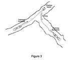
- FIG. 3 shows the typical maneuvers involved in a route for a mining vehicle
- FIG. 4 provides an example of the information stored in a route profile
- FIG. 5 shows the architecture of the playback control system
- FIG. 6 shows the how the rangefinder data is used to help determine the position and orientation of the vehicle with respect to the desired path.
- passageway environment means any space where vehicles might travel that contains walls, barriers, or obstacles such that said vehicles must travel amongst these objects.
- Examples of passageway environments include streets among buildings, building hallways, office spaces, underground mines, tunnels, caves, etc.
- passageway environments can be represented by maps.
- a “map” refers to a representation of a region of a passageway environment.
- metric map means a map in which the notion of distances between points on the map is defined.
- topological map means a map in which the notion of distances between points on the map is not defined.
- a “consistent map” refers to a map in which:
- global map or “globally consistent map” both mean a map of an environment that is consistent in the region expressed by the map, but which may have been created by combining one or more local maps.
- a local map is a global map in the region it expresses.
- range sensing device means a device for accurately measuring the distance to targets within a certain viewing scope of the device.
- the distance measurements can be based on any of a number of principles, including time-of-flight, triangulation, phase difference, etc.
- a “scan” refers to a set of distance data collected from the range sensing device at a particular instance.
- rangefinder is sometimes used as a synonym to “range sensing device,” and a “laser rangefinder” is a range sensing device that uses lasers and the time-of-flight principle to measure distance.
- position and orientation refers to an object's coordinates with respect to a fixed point together with its alignment (or bearing) with respect to a fixed axis.
- position and orientation of a vehicle in a passageway environment might be the coordinates of a point on the vehicle together with the bearing of the vehicle (e.g., in degrees).
- the word “pose” is used as a short form for “position and orientation.”
- kinematics model and “vehicle kinematics” typically refer to a model for the vehicle that considers only the rate of change of the vehicle's configuration. This is in contrast to a “dynamics model” or “vehicle dynamics,” which typically consider the forces and resulting accelerations that describe the vehicle's motion. In the same way, the words “kinematics” and “dynamics” are also used to describe the characteristics of different models for individual vehicle components or subsystems, such as actuators.
- inertial measurement unit means a device that comprises both accelerometers, for measuring acceleration along perpendicular axes, and angular rate sensors (e.g., gyroscopes), for measuring the pitch, roll, and yaw rates of the body to which the sensors are affixed.
- accelerometers for measuring acceleration along perpendicular axes
- angular rate sensors e.g., gyroscopes
- the phrase “odometric sensor(s)” means a device used to estimate the position and orientation of a vehicle using “dead-reckoning”. This dead-reckoned estimate is obtained by incrementally adding to a known initial position and orientation and can be based on data from one or more sensors, including data from an inertial measurement unit, optical encoders, toothed-gear and hall-effect sensor pairs, and a hinge-angle sensor. Moreover, this dead-reckoned estimate can use knowledge about the vehicle's kinematics to fuse data from the one or more odometric sensors.
- the word “odometry” is sometimes used as a short form for “estimate of vehicle position and orientation using odometric sensors”.
- path means a continuous set of points in a passageway environment that is traced out by a reference point on a vehicle during movement.
- route is used as a synonym for “path”.
- the present invention provides an automation system for the problem of driving a vehicle 10 as depicted in FIG. 1 through an underground mining environment defined by mine walls 17 and 18 .
- FIG. 2 there are three main operational steps to the invention: teaching, route profiling, and playback.
- a vehicle 10 for underground mining applications includes a front section 12 with wheels 14 and a rear section 16 having wheels 18 , an operator cab 15 and a bucket 13 for carrying ore mounted to the front of front section 12 .
- One or more rangefinder sensors e.g., laser rangefinders
- rangefinder 20 mounted in the rear vehicle section 16 and a rangefinder 22 mounted in front section 12 of vehicle 10 , are used to generate a profile of ranges around vehicle 10 .
- a computer processor 26 mounted on vehicle 10 is connected to rangefinders 20 and 22 for acquiring the range data from the rangefinders.
- the vehicle 10 includes one or more odometric sensors and may include for example wheel encoders 30 for measuring the rotation of the wheels 18 .
- Wheels 14 of front vehicle section 12 may include wheel encoders as well (not shown).
- a hinge 34 connecting vehicle sections 12 and 16 may include steering sensors 36 .
- Inertial measurement units may also be incorporated into vehicle 10 and computer processor 26 is configured to acquire data from the various odometric sensors.
- Cameras 40 may be mounted on the vehicle for image acquisition for remote operation of vehicle 10 for example.
- the vehicle 10 also optionally includes a radio receiver and computer processing means 26 may be configured to acquire information relating to radio frequency identification (RFID) tags as well to acquire information relating to communication infrastructure (e.g., signal strength to wireless Ethernet nodes).
- Vehicle 10 also preferably includes a capability to acquire information relating to the pitch/roll of the vehicle (e.g., from inclinometer sensors mounted on strategic parts of the vehicle), transmission gear of the vehicle, engine speed of the vehicle, and if present, pressures in any hydraulic cylinders required to steer the vehicle 10 , and a means to determine the acquisition times of all the aforementioned data and store them in the on-board memory of said computer processor 26 in a log file.
- RFID radio frequency identification
- a route can be comprised of a number of different maneuvers for the vehicle including: tramming forwards, tramming backwards, switching directions, turning, and pausing to carry out activities.
- a typical route will be between 30 meters and 3 kilometers in length but the present invention is not limited to any particular length of route.
- the route is defined by driving the vehicle 10 along it and logging all the available sensor data to a file.
- the vehicle 10 could be driven manually, wherein an operator sits in the cab 15 of the vehicle ( FIG. 1 ) and uses the vehicle's manual controls to operate the vehicle 10 .
- the operator could drive the vehicle remotely either by line-of-sight or tele-operation using cameras 40 mounted on the vehicle 10 .
- Remote operation requires the use of remote controls, which could include the use of a tele-operation station with a screen to display the output of vehicle-mounted cameras and similar controls to those found in the vehicle cab to operate the vehicle.
- the teaching should not require the operator to perform any actions in addition to those actions required to normally operate the vehicle 10 from the cab, with the exception of starting the data logging system before commencing the route and stopping the data logging system after completing the route.
- the present system includes a route profiling method to create a route profile of a passageway environment from one or more logs.
- a log is a file on a mass storage device accessible by the vehicle's computer processor 26 , which contains time-stamped sensor readings that were recorded during a teaching run along the route.
- the profiling method is used to process the raw sensor data contained in the log file into a route profile which is comprised of a vehicle path 1 , a sequence of local metric submaps 2 located along and defined relative to the path, and a speed profile 3 defined as a function of the distance along the path.
- the path 1 itself is determined using the logged data from the odometric sensors and a kinematics model.
- a hinge angle sensor and wheel odometer may be used to estimate the vehicle's hinge angle rate and translational speeds, respectively.
- the kinematics model consists of a mathematical relationship (i.e., an ordinary differential equation) that relates the logged hinge angle rate and translational speed to the position and orientation of the vehicle, as expressed in a frame of reference ( FIG. 4 ).
- the path itself is a contiguous set of points visited by a reference point on the vehicle during movement.
- the local metric submaps 2 are determined using both the odometric sensor data and the rangefinder sensor data.
- the current application discloses a different method of representing a map of the passageway environment than has been done before, using the sequence of local metric submaps, which better represents the raw shape of the passageways and can offer better vehicle localization in a passageway environment than other systems that use topological representations.
- metric maps are used, it is a sequence of these maps attached along the vehicle's path that forms the overall route profile; which is to say, the system does not rely on one monolithic map and an absolute frame of reference in which to express maps.
- the local submaps are grids of cells, wherein each cell takes on a value of either ‘occupied’ or ‘not occupied’.
- a cell is assigned to be ‘occupied’ if the region of the passageway environment represented by the cell contains an obstacle, such as a wall or other object.
- a cell is assigned to be ‘not occupied’ if the region it represents contains free space that is possibly traversable by the vehicle.
- This type of submap is sometimes called an occupancy grid. In this case, the resolution of the cells is at the centimeter scale.
- the laser rangefinder sensor readings logged while the vehicle was on the segment of the path contained within the boundary of the local submap are used to determine the cell values for the local submap.
- the spacing and boundaries of the sequence of local metric submaps are constructed using knowledge of the sensing range of the rangefinder sensors and such that there is sufficient overlap in the regions expressed by contiguous local metric submaps. This is to ensure, when the vehicle switches from one map to the next, that data from its one or more rangefinder sensors always lie within the boundary of a local metric submap.
- the speed profile 3 serves to provide the target speed for the vehicle during playback at all points along the path. This is necessary to ensure the vehicle slows down along certain portions of the path including approaching direction switches, turns, and approaching the end of the path.
- the speed profile is generated automatically to suit the particular vehicle path using preprogrammed rules. High speeds are assigned to sections of the path that are relatively straight. Lower speeds are assigned to sections of the path with higher curvature such that during playback the vehicle will slow down in corners. In one embodiment, the curvature of the path is estimated using the kinematics model described above and the logged vehicle hinge angle along the path. Lower speeds can also be assigned to sections of the path that come close to the wall. The wall distance can be determined by the logged laser rangefinder data along the path.
- the speed profile is constructed so as to provide smooth accelerations from a stop and smooth decelerations to a stop.
- the speed profile also contains information pertaining to which transmission gear the vehicle should be using at each point on the path. If present in the log, information pertaining to RFID tags and communication infrastructure can also be included in the route profile all expressed as functions, of distance along the path.
- the route profiling method could be executed using the on-board computer or the data log file could be moved to an off-board computer for processing and the resulting route profile file returned to the on-board computer memory for playback.
- the system is ready to play back the route.
- This is accomplished by way of a playback control system as depicted in FIG. 2 .
- the architecture of the playback control system is depicted in FIG. 5 . It is comprised of a localization method, a speed estimation method, a steering control method, a drive control method, and a safety method.
- a localization method e.g. 10 to 100 times per second.
- the first step is to use the localization method to determine where the vehicle is relative to the path contained in the route profile. This includes estimating the longitudinal distance along the path and the lateral and heading errors with respect to the path. When the vehicle is perfectly on the path and oriented so as to be parallel to the path's tangent, the lateral and heading errors are said to be zero. If the vehicle is slightly to one side of the path or the other, the lateral error is either positive (left) or negative (right). If the vehicle is slightly rotated with respect to the path's tangent, the heading error is either positive (anti-clockwise) or negative (clockwise). The lateral and heading errors determined by the localization method are passed to the steering control method.
- the localization method also serves to look up the desired speed for the vehicle using the estimate of its longitudinal position relative to the path (i.e., how far the vehicle is along the path).
- the desired. speed is passed to the drive control method.
- the speed estimation method serves to measure the actual speed of the vehicle using sensors and pass this speed estimate to the drive control method.
- the drive control method compares the actual speed to the desired speed and adjusts the drive commands sent to the vehicle so as to make the difference between the actual and desired speeds as small as possible.
- the steering control method adjusts the steering commands sent to the vehicle so as to make the lateral and heading errors as small as possible.
- the safety method acts as an independent check by looking for obstructions along the vehicle path and sending an emergency stop signal to the vehicle if such an obstruction is detected. Details of how all these steps are accomplished will now be provided, broken down by the main blocks of the playback control system architecture.
- the task of the localization method is to determine where the vehicle is relative to the path contained in the route profile. This includes estimating the longitudinal distance along the path and the lateral and heading errors with respect to the path. This is accomplished using the odometric sensors for dead-reckoning and rangefinder sensors for correcting said dead-reckoning using the local metric submaps located along the vehicle path in the route profile.
- a dead-reckoned estimate of the vehicle's position and orientation is determined using odometric sensors and a kinematics model for the vehicle, in a manner similar to that used for estimating the vehicle path described in the section on route profiling above.
- a hinge angle sensor and wheel odometer may be used to estimate the vehicle's hinge angle rate and translational speeds, respectively.
- the kinematics model comprises a mathematical relationship (i.e., an ordinary differential equation) that relates the logged hinge angle rate and translational speed to the position and orientation of the vehicle, as expressed in a frame of reference ( FIG. 4 ).
- corrections to the dead-reckoned estimate are made using the local metric submaps located along the path in the route profile and the sensor readings from the laser rangefinders.
- the dead-reckoned estimate serves as an initial guess for the position/orientation of the vehicle with respect to the path.
- a correction method starts with this initial guess and refines it so as to ensure the sensor readings from the laser rangefinder are well-matched to the currently active local metric submap. This scenario is depicted in FIG. 6 , wherein the laser rangefinder sensor readings 3 have been aligned to the local metric submap 2 . Because the local metric submap is defined with respect to the vehicle path 1 , it is a simple matter of geometry to determine the position and orientation of the vehicle with respect to the path.
- the (corrected) vehicle estimate is reasonably parallel to the path but shifted to the left of the path.
- the vehicle will have two laser rangefinders, one pointing forwards and one pointing backwards.
- only the laser rangefinder pointing in the direction of current movement is used to correct the vehicle position/orientation.
- both laser rangefinders are used.
- the squared error for an individual laser rangefinder range measurement is the square of the difference between the measured range and the expected range.
- the sum of squared errors is this quantity, summed over all the range measurements.
- a weighted sum of squared errors places more weight on some of the range measurements than others by considering the uncertainty associated with the individual sensor readings.
- the expected range is the range one would expect to measure from the dead-reckoned estimate of the vehicle position and orientation, using the local metric submap and a ray-tracing algorithm to probe along the scan line.
- the ray-tracing algorithm steps along the scan line outwards from the vehicle's rangefinder sensor location in the scan direction in small increments until an occupied grid cell is found on the local metric submap.
- the expected range is the distance from the vehicle's rangefinder sensor to the occupied grid cell.
- the popular Iterative Closest Point algorithm is used to perform the alignment.
- a particle filter is used to perform the alignment.
- a Kalman filter is used to perform the alignment.
- the identity of the currently active local metric submap is determined using the longitudinal position of the vehicle from the previous iteration of the control system (as defined in the playback overview above).
- a handoff scheme is used to ensure the system progresses through the sequence of local metric submaps as the vehicle moves along the path.
- the speed estimation method serves to measure the actual translational speed of the vehicle using sensors and passes this speed estimate to the drive control method.
- a wheel encoder 30 is used to estimate the vehicle's longitudinal speed.
- the wheel encoder 30 is mounted on the wheel axle.
- the wheel encoder 30 is mounted on the drive shaft.
- the wheel encoder 30 is mounted on its own shaft equipped with a wheel and is held against the vehicle wheel using a spring. Regardless of the embodiment, the speed is estimated by first estimating the distance traveled and then differentiating this signal. The distance traveled is estimated by multiplying the number of encoder revolutions by a calibrated factor.
- the calibrated factor is determined by driving the vehicle a known distance (as measured using, for example, a tape measure) in a straight line and dividing this distance by the number of resulting wheel encoder turns.
- the distance traveled is turned into a speed measurement using a differentiator.
- the differentiator takes the distance traveled over a short time interval and divides by this time interval.
- a filter is used to smooth out the speed estimate, which will inevitably be noisy due to the quantization introduced by the encoder and the time interval.
- the speed estimate is positive for forwards tramming and negative for backwards tramming.
- the estimated speed is passed to the drive control method for comparison with the desired speed.
- the drive control method is used to regulate the speed of the vehicle, similarly to the cruise control function in a standard automobile.
- the inputs required by the drive control method are an estimate of the vehicle's actual speed, which is provided by the speed estimation method described above, and the desired speed of the vehicle at the current distance along the path, which is provided by the localization method.
- the first step in this method is to compute the speed error, which is the difference of the desired vehicle speed and the actual vehicle speed. If the desired speed and the actual speed are the same, the speed error is zero.
- the drive control method uses this speed error to alter the drive commands being sent to the vehicle.
- the drive commands are comprised of throttle brake, and possibly the transmissions gear.
- a standard controller is used to update the drive commands based on the current speed error.
- a gear-switching logic and a standard proportional-integral-derivative (PID) controller is used to update the drive commands based on the current speed error.
- the PID controller is derived based on knowledge of the vehicle's driveline dynamics including such components as engine dynamics, transmission and gear switching dynamics, torque converter dynamics, vehicle translational dynamics, passageway grade (as sensed by inclinometers), driveshaft-axle dynamics, and wheel-ground interaction dynamics. Knowledge of these dynamics is based on vehicle specifications and system identification. Key controller parameters, known as controller gains, can be adjusted once the drive control method is executing on the vehicle, so as to achieve the desired response of the vehicle to a change in the desired speed. For example, the desired speed should be tracked as quickly as possible without the actual speed overshooting the desired speed.
- the steering control method adjusts the steering commands sent to the vehicle so as to make the vehicle track the path defined in the route profile as closely as possible. This is accomplished by first receiving the lateral and heading errors from the localization method, as described above. When the vehicle is perfectly on the path and oriented so as to be parallel to the path's tangent, the lateral and heading errors are said to be zero. If the vehicle is slightly to one side of the path or the other, the lateral error is either positive (left) or negative (right). If the vehicle is slightly rotated with respect to the path's tangent the heading error is either positive (anti-clockwise) or negative (clockwise). The role of the steering control method is to use these lateral and heading errors to adjust the steering commands sent to the vehicle.
- the steering commands are comprised of a signal sent to a proportional hydraulic valve which in turn causes hydraulic cylinders to actuate the hinge joint.
- a path-tracking controller is used to update the steering commands based on the current lateral and heading errors.
- the path-tracking controller is derived based on knowledge of the vehicle's steering kinematics and dynamics including such components as hydraulic dynamics (i.e., steering valve, steering cylinders, hydraulic pump, pressure relief valves), vehicle rotational dynamics, and wheel-ground interaction dynamics. Knowledge of these kinematics and dynamics is based on vehicle specifications and system identification. Key controller parameters can be adjusted once the steering control method is executing on the vehicle so as to achieve the desired response of the vehicle when tracking a path. For example, the vehicle should not oscillate or wobble about the path and should not take turns too widely.
- the safety method acts as an independent check by looking for obstructions along the vehicle path and sending an emergency stop signal to the vehicle if such an obstruction is detected. This is accomplished by monitoring the sensor readings from the laser rangefinders, particularly from the sensor pointing in the direction of travel of the mining vehicle.
- a fixed region is defined relative to the vehicle a distance ahead of the vehicle and any laser rangefinders sensor readings that fall within this region indicate an obstruction.
- a dynamic region is used wherein the vehicle looks further ahead along the path for obstructions when its speed is higher.
- an obstruction is indicated when the actual laser rangefinder sensor readings and the expected laser rangefinder sensor readings, as determined using the local metric submap, differ by a predetermined amount.
- an emergency stop signal is sent to the vehicle in the event an obstruction is detected, which should fully engage the brakes, set the throttle to zero, and put vehicle in neutral.
- the safety method could be considered part of an overall safety system for autotramming. Although this safety method provides an independent check, additional measures such as looking for the presence and/or absence of signals arising from RFID tags/readers and/or communication infrastructure access points can help to confirm the position/orientation information generated by the localization method described herein.
- the guidance, navigation, and control system for a mining vehicle disclosed herein is very advantageous because of its ability to enable operatorless and infrastructureless tramming through underground passageways, thereby reducing the risk and cost of tramming when compared to manual operations.
- the terms “comprises”, “comprising”, “including” and “includes” are to be construed as being inclusive and open-ended. Specifically, when used in this document, the terms “comprises”, “comprising”, “including”, “includes” and variations thereof, mean the specified features, steps or components are included in the described invention. These terms are not to be interpreted to exclude the presence of other features, steps or components.
Priority Applications (1)
| Application Number | Priority Date | Filing Date | Title |
|---|---|---|---|
| US11/922,706 US8090491B2 (en) | 2005-07-26 | 2006-07-26 | Guidance, navigation, and control system for a vehicle |
Applications Claiming Priority (3)
| Application Number | Priority Date | Filing Date | Title |
|---|---|---|---|
| US70228505P | 2005-07-26 | 2005-07-26 | |
| US11/922,706 US8090491B2 (en) | 2005-07-26 | 2006-07-26 | Guidance, navigation, and control system for a vehicle |
| PCT/CA2006/001261 WO2007012198A1 (en) | 2005-07-26 | 2006-07-26 | Guidance, navigation, and control system for a vehicle |
Related Parent Applications (1)
| Application Number | Title | Priority Date | Filing Date |
|---|---|---|---|
| PCT/CA2006/001261 A-371-Of-International WO2007012198A1 (en) | 2005-07-26 | 2006-07-26 | Guidance, navigation, and control system for a vehicle |
Related Child Applications (1)
| Application Number | Title | Priority Date | Filing Date |
|---|---|---|---|
| US13/209,247 Division US8260483B2 (en) | 2005-07-26 | 2011-08-12 | Guidance, navigation, and control system for a vehicle |
Publications (2)
| Publication Number | Publication Date |
|---|---|
| US20090043439A1 US20090043439A1 (en) | 2009-02-12 |
| US8090491B2 true US8090491B2 (en) | 2012-01-03 |
Family
ID=37682969
Family Applications (3)
| Application Number | Title | Priority Date | Filing Date |
|---|---|---|---|
| US11/493,027 Active 2028-12-19 US7756615B2 (en) | 2005-07-26 | 2006-07-26 | Traffic management system for a passageway environment |
| US11/922,706 Active 2028-10-24 US8090491B2 (en) | 2005-07-26 | 2006-07-26 | Guidance, navigation, and control system for a vehicle |
| US13/209,247 Active US8260483B2 (en) | 2005-07-26 | 2011-08-12 | Guidance, navigation, and control system for a vehicle |
Family Applications Before (1)
| Application Number | Title | Priority Date | Filing Date |
|---|---|---|---|
| US11/493,027 Active 2028-12-19 US7756615B2 (en) | 2005-07-26 | 2006-07-26 | Traffic management system for a passageway environment |
Family Applications After (1)
| Application Number | Title | Priority Date | Filing Date |
|---|---|---|---|
| US13/209,247 Active US8260483B2 (en) | 2005-07-26 | 2011-08-12 | Guidance, navigation, and control system for a vehicle |
Country Status (8)
| Country | Link |
|---|---|
| US (3) | US7756615B2 (de) |
| EP (3) | EP1913235B1 (de) |
| AT (1) | ATE504872T1 (de) |
| AU (3) | AU2006274421B2 (de) |
| CA (2) | CA2612921C (de) |
| DE (1) | DE602006021188D1 (de) |
| WO (2) | WO2007012199A2 (de) |
| ZA (2) | ZA200800635B (de) |
Cited By (8)
| Publication number | Priority date | Publication date | Assignee | Title |
|---|---|---|---|---|
| US20110282581A1 (en) * | 2010-05-12 | 2011-11-17 | Gm Global Technology Operations, Inc. | Object and vehicle detection and tracking using 3-d laser rangefinder |
| US20120185112A1 (en) * | 2011-01-19 | 2012-07-19 | Electronics And Telecommunications Research Institute | Apparatus and method for detecting location of vehicle |
| US20130060456A1 (en) * | 2011-09-02 | 2013-03-07 | Peyman Pourparhizkar | Synchronizing car movements in road to reduce traffic |
| US8783784B2 (en) | 2011-08-27 | 2014-07-22 | Logan Hydraulics Co. | Material and equipment recovery system |
| US20140297182A1 (en) * | 2013-03-29 | 2014-10-02 | Modular Mining Systems, Inc. | Contention avoidance |
| US8905487B2 (en) | 2011-10-28 | 2014-12-09 | Robert Wayne Graham | Mine equipment recovery system |
| US10713954B2 (en) * | 2015-09-11 | 2020-07-14 | Robert Bosch Gmbh | Method and apparatus for operating a vehicle |
| US11772687B1 (en) * | 2022-03-21 | 2023-10-03 | China University Of Mining And Technology | Low-energy-consumption grading and positioning method for coal mine auxiliary transportation vehicle and system thereof |
Families Citing this family (276)
| Publication number | Priority date | Publication date | Assignee | Title |
|---|---|---|---|---|
| US11835343B1 (en) * | 2004-08-06 | 2023-12-05 | AI Incorporated | Method for constructing a map while performing work |
| US7409295B2 (en) * | 2004-08-09 | 2008-08-05 | M/A-Com, Inc. | Imminent-collision detection system and process |
| US20060224318A1 (en) * | 2005-03-30 | 2006-10-05 | Wilson Robert C Jr | Trajectory prediction |
| CA2634961A1 (en) * | 2005-12-30 | 2007-07-12 | Bhp Billiton Innovation Pty Ltd. | Waste disposal during pit mining |
| DE102006031580A1 (de) | 2006-07-03 | 2008-01-17 | Faro Technologies, Inc., Lake Mary | Verfahren und Vorrichtung zum dreidimensionalen Erfassen eines Raumbereichs |
| US7801644B2 (en) | 2006-07-05 | 2010-09-21 | Battelle Energy Alliance, Llc | Generic robot architecture |
| US7974738B2 (en) * | 2006-07-05 | 2011-07-05 | Battelle Energy Alliance, Llc | Robotics virtual rail system and method |
| US7620477B2 (en) * | 2006-07-05 | 2009-11-17 | Battelle Energy Alliance, Llc | Robotic intelligence kernel |
| US8271132B2 (en) * | 2008-03-13 | 2012-09-18 | Battelle Energy Alliance, Llc | System and method for seamless task-directed autonomy for robots |
| US7668621B2 (en) * | 2006-07-05 | 2010-02-23 | The United States Of America As Represented By The United States Department Of Energy | Robotic guarded motion system and method |
| US8073564B2 (en) | 2006-07-05 | 2011-12-06 | Battelle Energy Alliance, Llc | Multi-robot control interface |
| US8355818B2 (en) | 2009-09-03 | 2013-01-15 | Battelle Energy Alliance, Llc | Robots, systems, and methods for hazard evaluation and visualization |
| US8965578B2 (en) * | 2006-07-05 | 2015-02-24 | Battelle Energy Alliance, Llc | Real time explosive hazard information sensing, processing, and communication for autonomous operation |
| US7587260B2 (en) * | 2006-07-05 | 2009-09-08 | Battelle Energy Alliance, Llc | Autonomous navigation system and method |
| US8005100B2 (en) * | 2006-09-21 | 2011-08-23 | Active Control Technology Inc. | Network for confined hazardous or other extreme environments |
| DE102006047131A1 (de) * | 2006-10-05 | 2008-04-10 | Robert Bosch Gmbh | Verfahren zum automatischen Steuern eines Fahrzeugs |
| EP2482209A1 (de) | 2006-10-05 | 2012-08-01 | Splunk Inc. | Zeitreihensuchmaschine |
| US7814978B2 (en) | 2006-12-14 | 2010-10-19 | Halliburton Energy Services, Inc. | Casing expansion and formation compression for permeability plane orientation |
| KR100910114B1 (ko) * | 2007-07-09 | 2009-08-03 | 팅크웨어(주) | 네비게이션 시스템 및 구간별 속도 제한정보 안내방법 |
| US7792710B2 (en) * | 2007-09-21 | 2010-09-07 | Sunrise R&D Holdings, Llc | Methods of influencing shoppers at the first moment of truth in a retail establishment |
| US7742952B2 (en) | 2008-03-21 | 2010-06-22 | Sunrise R&D Holdings, Llc | Systems and methods of acquiring actual real-time shopper behavior data approximate to a moment of decision by a shopper |
| US7783527B2 (en) * | 2007-09-21 | 2010-08-24 | Sunrise R&D Holdings, Llc | Systems of influencing shoppers at the first moment of truth in a retail establishment |
| US7739157B2 (en) | 2008-01-15 | 2010-06-15 | Sunrise R&D Holdings, Llc | Method of tracking the real time location of shoppers, associates, managers and vendors through a communication multi-network within a store |
| US7734513B2 (en) * | 2007-07-13 | 2010-06-08 | Sunrise R&D Holdings, Llc | System of tracking the real time location of shoppers, associates, managers and vendors through a communication multi-network within a store |
| KR100883520B1 (ko) * | 2007-07-23 | 2009-02-13 | 한국전자통신연구원 | 실내 환경지도 작성 시스템 및 방법 |
| JP5114123B2 (ja) * | 2007-07-24 | 2013-01-09 | トヨタ自動車株式会社 | 車載装置制御システム |
| US7640975B2 (en) | 2007-08-01 | 2010-01-05 | Halliburton Energy Services, Inc. | Flow control for increased permeability planes in unconsolidated formations |
| US20090062958A1 (en) * | 2007-08-31 | 2009-03-05 | Morris Aaron C | Autonomous mobile robot |
| US8428918B2 (en) * | 2007-09-19 | 2013-04-23 | Utc Fire & Security Corporation | System and method for occupancy estimation |
| WO2009038561A1 (en) * | 2007-09-19 | 2009-03-26 | United Technologies Corporation | System and method for threat propagation estimation |
| WO2009038558A1 (en) * | 2007-09-19 | 2009-03-26 | United Technologies Corporation | System and method for occupancy estimation |
| US20100299116A1 (en) * | 2007-09-19 | 2010-11-25 | United Technologies Corporation | System and method for occupancy estimation |
| WO2009038563A1 (en) * | 2007-09-20 | 2009-03-26 | United Technologies Corporation | Model-based egress support system |
| US8103438B2 (en) | 2007-09-26 | 2012-01-24 | Trimble Navigation Limited | Method and system for automatically directing traffic on a site |
| US8144000B2 (en) * | 2007-09-26 | 2012-03-27 | Trimble Navigation Limited | Collision avoidance |
| US20090105939A1 (en) * | 2007-10-22 | 2009-04-23 | Toyota Motor Engineering & Manufacturing North America, Inc. | Vehicle navigation system with obstacle avoidance |
| KR101372482B1 (ko) * | 2007-12-11 | 2014-03-26 | 삼성전자주식회사 | 이동 로봇의 경로 계획 방법 및 장치 |
| US7832477B2 (en) | 2007-12-28 | 2010-11-16 | Halliburton Energy Services, Inc. | Casing deformation and control for inclusion propagation |
| KR101457148B1 (ko) * | 2008-05-21 | 2014-10-31 | 삼성전자 주식회사 | 로봇의 위치 추정 장치 및 그 방법 |
| SE532431C2 (sv) | 2008-05-30 | 2010-01-19 | Atlas Copco Rock Drills Ab | Metod och anordning för bestämning av en överensstämmelse mellan en representation av en omgivning och nämnda omgivning |
| US8396755B2 (en) | 2008-07-14 | 2013-03-12 | Sunrise R&D Holdings, Llc | Method of reclaiming products from a retail store |
| US20100106344A1 (en) * | 2008-10-27 | 2010-04-29 | Edwards Dean B | Unmanned land vehicle having universal interfaces for attachments and autonomous operation capabilities and method of operation thereof |
| US20100135178A1 (en) | 2008-11-21 | 2010-06-03 | Qualcomm Incorporated | Wireless position determination using adjusted round trip time measurements |
| US8892127B2 (en) * | 2008-11-21 | 2014-11-18 | Qualcomm Incorporated | Wireless-based positioning adjustments using a motion sensor |
| US9645225B2 (en) * | 2008-11-21 | 2017-05-09 | Qualcomm Incorporated | Network-centric determination of node processing delay |
| US20100130230A1 (en) * | 2008-11-21 | 2010-05-27 | Qualcomm Incorporated | Beacon sectoring for position determination |
| US9125153B2 (en) * | 2008-11-25 | 2015-09-01 | Qualcomm Incorporated | Method and apparatus for two-way ranging |
| US8886453B2 (en) | 2008-12-11 | 2014-11-11 | Telogis, Inc. | System and method for efficient routing on a network in the presence of multiple-edge restrictions and other constraints |
| MX2011006174A (es) * | 2008-12-11 | 2012-02-28 | Telogis Inc | Sistema y metodo para enrutamiento eficiente en una red en la presencia de restricciones de multiples bordes y otras limitaciones. |
| US8768344B2 (en) | 2008-12-22 | 2014-07-01 | Qualcomm Incorporated | Post-deployment calibration for wireless position determination |
| US8750267B2 (en) * | 2009-01-05 | 2014-06-10 | Qualcomm Incorporated | Detection of falsified wireless access points |
| US8315802B2 (en) * | 2009-02-11 | 2012-11-20 | Telogis, Inc. | Systems and methods for analyzing the use of mobile resources |
| DE102009010465B3 (de) | 2009-02-13 | 2010-05-27 | Faro Technologies, Inc., Lake Mary | Laserscanner |
| US9551575B2 (en) | 2009-03-25 | 2017-01-24 | Faro Technologies, Inc. | Laser scanner having a multi-color light source and real-time color receiver |
| DE102009015920B4 (de) | 2009-03-25 | 2014-11-20 | Faro Technologies, Inc. | Vorrichtung zum optischen Abtasten und Vermessen einer Umgebung |
| US8384776B2 (en) * | 2009-04-22 | 2013-02-26 | Toyota Motor Engineering And Manufacturing North America, Inc. | Detection of topological structure from sensor data with application to autonomous driving in semi-structured environments |
| FI20095712A (fi) * | 2009-06-24 | 2010-12-25 | Sandvik Mining & Constr Oy | Ohjaustietojen määrittäminen liikkuvan kaivoskoneen automaattista ohjaamista varten |
| FI20095713A (fi) | 2009-06-24 | 2010-12-25 | Sandvik Mining & Constr Oy | Ajoreitin määrittäminen liikkuvan kaivoskoneen automaattisen ohjaamisen järjestämiseksi |
| FI20095714A (fi) * | 2009-06-24 | 2010-12-25 | Sandvik Mining & Constr Oy | Ajoreitin määrittäminen liikkuvan kaivoskoneen automaattisen ohjaamisen järjestämiseksi |
| FI20095715A (fi) * | 2009-06-24 | 2010-12-25 | Sandvik Mining & Constr Oy | Liikkuvan kaivoskoneen automaattista ohjaamista varten käytettävän mallin opettaminen |
| FI20095716L (fi) * | 2009-06-24 | 2010-12-25 | Sandvik Mining & Constr Oy | Liikkuvan kaivoskoneen automaattista ohjaamista varten tarvittavien tietojen määrittäminen |
| DE102009035337A1 (de) | 2009-07-22 | 2011-01-27 | Faro Technologies, Inc., Lake Mary | Verfahren zum optischen Abtasten und Vermessen eines Objekts |
| DE102009035336B3 (de) * | 2009-07-22 | 2010-11-18 | Faro Technologies, Inc., Lake Mary | Vorrichtung zum optischen Abtasten und Vermessen einer Umgebung |
| AU2010282260B2 (en) | 2009-08-14 | 2015-02-19 | Telogis, Inc. | Real time map rendering with data clustering and expansion and overlay |
| DE102009040800B4 (de) * | 2009-09-09 | 2017-03-23 | Knorr-Bremse Systeme für Nutzfahrzeuge GmbH | Vorrichtung zur Geschwindigkeitskontrolle eines Fahrzeugs mit Geschwindigkeitsdirekteinstellungsbedienelement |
| TW201113544A (en) * | 2009-10-06 | 2011-04-16 | Univ Nat Taiwan | Method to forecast location of object |
| US9210288B2 (en) | 2009-11-20 | 2015-12-08 | Faro Technologies, Inc. | Three-dimensional scanner with dichroic beam splitters to capture a variety of signals |
| DE102009055988B3 (de) | 2009-11-20 | 2011-03-17 | Faro Technologies, Inc., Lake Mary | Vorrichtung zum optischen Abtasten und Vermessen einer Umgebung |
| US9113023B2 (en) | 2009-11-20 | 2015-08-18 | Faro Technologies, Inc. | Three-dimensional scanner with spectroscopic energy detector |
| DE102009055989B4 (de) | 2009-11-20 | 2017-02-16 | Faro Technologies, Inc. | Vorrichtung zum optischen Abtasten und Vermessen einer Umgebung |
| US9529083B2 (en) | 2009-11-20 | 2016-12-27 | Faro Technologies, Inc. | Three-dimensional scanner with enhanced spectroscopic energy detector |
| DE102009057101A1 (de) | 2009-11-20 | 2011-05-26 | Faro Technologies, Inc., Lake Mary | Vorrichtung zum optischen Abtasten und Vermessen einer Umgebung |
| US9230292B2 (en) * | 2012-11-08 | 2016-01-05 | Uber Technologies, Inc. | Providing on-demand services through use of portable computing devices |
| AU2010325793B2 (en) | 2009-12-04 | 2015-03-12 | Uber Technologies, Inc. | System and method for arranging transport amongst parties through use of mobile devices |
| US9607239B2 (en) | 2010-01-20 | 2017-03-28 | Faro Technologies, Inc. | Articulated arm coordinate measurement machine having a 2D camera and method of obtaining 3D representations |
| US9628775B2 (en) | 2010-01-20 | 2017-04-18 | Faro Technologies, Inc. | Articulated arm coordinate measurement machine having a 2D camera and method of obtaining 3D representations |
| US9163922B2 (en) | 2010-01-20 | 2015-10-20 | Faro Technologies, Inc. | Coordinate measurement machine with distance meter and camera to determine dimensions within camera images |
| GB2490452A (en) | 2010-01-20 | 2012-10-31 | Faro Tech Inc | Integrated part temperature measurement system |
| US9879976B2 (en) | 2010-01-20 | 2018-01-30 | Faro Technologies, Inc. | Articulated arm coordinate measurement machine that uses a 2D camera to determine 3D coordinates of smoothly continuous edge features |
| JP5200297B2 (ja) * | 2010-01-25 | 2013-06-05 | 株式会社小松製作所 | 車両の走行システムおよびその走行方法 |
| US8836490B2 (en) | 2010-04-09 | 2014-09-16 | Dsg Tag Systems Inc. | Vehicle management |
| US9280902B2 (en) | 2010-04-09 | 2016-03-08 | DSG TAG Systems, Inc. | Facilities management |
| US8781492B2 (en) | 2010-04-30 | 2014-07-15 | Qualcomm Incorporated | Device for round trip time measurements |
| FI121762B (fi) * | 2010-05-10 | 2011-03-31 | Sandvik Mining & Constr Oy | Menetelmä ja laitteisto kaivosajoneuvon paikantamisen järjestämiseksi |
| DE102010020925B4 (de) | 2010-05-10 | 2014-02-27 | Faro Technologies, Inc. | Verfahren zum optischen Abtasten und Vermessen einer Umgebung |
| FI122157B (fi) | 2010-05-10 | 2011-09-15 | Sandvik Mining & Constr Oy | Menetelmä ja laitteisto kaivosajoneuvon turvajärjestelyitä varten |
| FI124051B (fi) | 2010-05-25 | 2014-02-28 | Sandvik Mining & Constr Oy | Kallionporauslaite ja menetelmä sen paikoittamiseksi |
| US20130103302A1 (en) * | 2010-06-23 | 2013-04-25 | Stephen T'Siobbel | Electronic map creation process |
| DE102010032723B3 (de) | 2010-07-26 | 2011-11-24 | Faro Technologies, Inc. | Vorrichtung zum optischen Abtasten und Vermessen einer Umgebung |
| DE102010032726B3 (de) | 2010-07-26 | 2011-11-24 | Faro Technologies, Inc. | Vorrichtung zum optischen Abtasten und Vermessen einer Umgebung |
| DE102010032725B4 (de) | 2010-07-26 | 2012-04-26 | Faro Technologies, Inc. | Vorrichtung zum optischen Abtasten und Vermessen einer Umgebung |
| DE102010033561B3 (de) | 2010-07-29 | 2011-12-15 | Faro Technologies, Inc. | Vorrichtung zum optischen Abtasten und Vermessen einer Umgebung |
| US8275508B1 (en) | 2011-03-03 | 2012-09-25 | Telogis, Inc. | History timeline display for vehicle fleet management |
| US8972149B2 (en) | 2010-10-27 | 2015-03-03 | Caterpillar Inc. | Control system implementing derate based on air characteristics |
| US9168654B2 (en) | 2010-11-16 | 2015-10-27 | Faro Technologies, Inc. | Coordinate measuring machines with dual layer arm |
| US8751103B2 (en) * | 2010-11-22 | 2014-06-10 | Caterpillar Inc. | Object detection system having interference avoidance strategy |
| US8744693B2 (en) * | 2010-11-22 | 2014-06-03 | Caterpillar Inc. | Object detection system having adjustable focus |
| KR20120072124A (ko) * | 2010-12-23 | 2012-07-03 | 한국전자통신연구원 | 실내 전자지도 데이터 생성 방법 |
| BR112013026178A2 (pt) * | 2011-04-11 | 2019-10-01 | Crown Equipment Ltd | método e sistema para coordenar o planejamento de trajeto |
| US11334092B2 (en) * | 2011-07-06 | 2022-05-17 | Peloton Technology, Inc. | Devices, systems, and methods for transmitting vehicle data |
| US9594772B2 (en) | 2011-07-27 | 2017-03-14 | International Business Machines Corporation | Multi-modal journey planner |
| RU2617498C2 (ru) | 2011-08-03 | 2017-04-25 | ДЖОЙ ЭмЭм ДЕЛАВЭР, ИНК. | Автоматизированные операции горной машины |
| WO2013028221A1 (en) | 2011-08-19 | 2013-02-28 | Aerovironment Inc. | Deep stall aircraft landing |
| WO2013062608A2 (en) | 2011-08-19 | 2013-05-02 | Aerovironment Inc. | Inverted-landing aircraft |
| US20140058634A1 (en) | 2012-08-24 | 2014-02-27 | Crown Equipment Limited | Method and apparatus for using unique landmarks to locate industrial vehicles at start-up |
| US9056754B2 (en) | 2011-09-07 | 2015-06-16 | Crown Equipment Limited | Method and apparatus for using pre-positioned objects to localize an industrial vehicle |
| WO2013043928A2 (en) | 2011-09-20 | 2013-03-28 | Telogis, Inc. | Vehicle fleet work order management system |
| SE536333C2 (sv) | 2011-11-18 | 2013-08-27 | Atlas Copco Rock Drills Ab | Förfarande och anordning för att framföra en gruv- och/elleranläggningsmaskin |
| SE537371C2 (sv) * | 2011-11-18 | 2015-04-14 | Atlas Copco Rock Drills Ab | Förfarande och anordning vid framförande av en gruv- och/eller anläggningsmaskin |
| US10846497B2 (en) | 2011-12-05 | 2020-11-24 | Adasa Inc. | Holonomic RFID reader |
| US10476130B2 (en) | 2011-12-05 | 2019-11-12 | Adasa Inc. | Aerial inventory antenna |
| US9780435B2 (en) | 2011-12-05 | 2017-10-03 | Adasa Inc. | Aerial inventory antenna |
| US11093722B2 (en) | 2011-12-05 | 2021-08-17 | Adasa Inc. | Holonomic RFID reader |
| US9747480B2 (en) | 2011-12-05 | 2017-08-29 | Adasa Inc. | RFID and robots for multichannel shopping |
| US10050330B2 (en) | 2011-12-05 | 2018-08-14 | Adasa Inc. | Aerial inventory antenna |
| KR20130068249A (ko) * | 2011-12-15 | 2013-06-26 | 한국전자통신연구원 | 이동체의 위치 추정 장치 및 방법 |
| DE102012100609A1 (de) | 2012-01-25 | 2013-07-25 | Faro Technologies, Inc. | Vorrichtung zum optischen Abtasten und Vermessen einer Umgebung |
| US9760092B2 (en) | 2012-03-16 | 2017-09-12 | Waymo Llc | Actively modifying a field of view of an autonomous vehicle in view of constraints |
| EP2648060A1 (de) * | 2012-04-04 | 2013-10-09 | ABB Research Ltd. | Verfahren zur Verfolgung eines Materialloses in einem Prozess zur Herstellung von Rohmaterial oder teilverarbeitetem Material |
| SE537163C2 (sv) | 2012-05-02 | 2015-02-24 | Atlas Copco Rock Drills Ab | Metod och system för manövrering av en mobil gruvmaskin i entunnel och en mobil gruvmaskin |
| SE536499C2 (sv) * | 2012-05-28 | 2014-01-02 | Scania Cv Ab | Autonom lastbil utan förarhytt och förfarande för lastbilsanvändning |
| US9669828B2 (en) | 2012-06-01 | 2017-06-06 | Toyota Motor Engineering & Manufacturing North America, Inc. | Cooperative driving and collision avoidance by distributed receding horizon control |
| US20130339098A1 (en) | 2012-06-15 | 2013-12-19 | Telogis, Inc. | Vehicle fleet routing system |
| US20130339266A1 (en) | 2012-06-15 | 2013-12-19 | Telogis, Inc. | Vehicle fleet routing system |
| US8997362B2 (en) | 2012-07-17 | 2015-04-07 | Faro Technologies, Inc. | Portable articulated arm coordinate measuring machine with optical communications bus |
| US9958272B2 (en) | 2012-08-10 | 2018-05-01 | Telogis, Inc. | Real-time computation of vehicle service routes |
| DE102012107544B3 (de) | 2012-08-17 | 2013-05-23 | Faro Technologies, Inc. | Vorrichtung zum optischen Abtasten und Vermessen einer Umgebung |
| WO2014039623A1 (en) | 2012-09-06 | 2014-03-13 | Faro Technologies, Inc. | Laser scanner with additional sensing device |
| GB2522142A (en) | 2012-09-14 | 2015-07-15 | Faro Tech Inc | Laser scanner with dynamical adjustment of angular scan velocity |
| US9052209B2 (en) * | 2012-09-24 | 2015-06-09 | Caterpillar Inc. | Location services in mining vehicle operations |
| DE102012109481A1 (de) | 2012-10-05 | 2014-04-10 | Faro Technologies, Inc. | Vorrichtung zum optischen Abtasten und Vermessen einer Umgebung |
| US9513107B2 (en) | 2012-10-05 | 2016-12-06 | Faro Technologies, Inc. | Registration calculation between three-dimensional (3D) scans based on two-dimensional (2D) scan data from a 3D scanner |
| US10067231B2 (en) | 2012-10-05 | 2018-09-04 | Faro Technologies, Inc. | Registration calculation of three-dimensional scanner data performed between scans based on measurements by two-dimensional scanner |
| US9406222B2 (en) * | 2012-10-18 | 2016-08-02 | Calamp Corp. | Systems and methods for location reporting of detected events in vehicle operation |
| US9177404B2 (en) | 2012-10-31 | 2015-11-03 | Qualcomm Incorporated | Systems and methods of merging multiple maps for computer vision based tracking |
| US8880301B2 (en) | 2012-11-14 | 2014-11-04 | Deere & Company | Torque control for front wheel drive |
| US9056624B2 (en) * | 2012-11-14 | 2015-06-16 | Deere & Company | Front wheel drive control |
| US10107831B2 (en) | 2012-11-21 | 2018-10-23 | Calamp Corp | Systems and methods for efficient characterization of acceleration events |
| ES2476565B2 (es) * | 2012-12-14 | 2015-01-30 | Universidad De Alicante | Método de localización y mapeo simultáneo para dispositivos robóticos |
| CN103884330B (zh) * | 2012-12-21 | 2016-08-10 | 联想(北京)有限公司 | 信息处理方法、可移动电子设备、引导设备和服务器 |
| US10466269B2 (en) | 2013-02-19 | 2019-11-05 | Calamp Corp. | Systems and methods for low latency 3-axis accelerometer calibration |
| US8996224B1 (en) * | 2013-03-15 | 2015-03-31 | Google Inc. | Detecting that an autonomous vehicle is in a stuck condition |
| US8849494B1 (en) | 2013-03-15 | 2014-09-30 | Google Inc. | Data selection by an autonomous vehicle for trajectory modification |
| US9008890B1 (en) | 2013-03-15 | 2015-04-14 | Google Inc. | Augmented trajectories for autonomous vehicles |
| US9677887B2 (en) | 2013-03-22 | 2017-06-13 | Qualcomm Incorporated | Estimating an initial position and navigation state using vehicle odometry |
| CN104077311B (zh) | 2013-03-28 | 2017-11-14 | 国际商业机器公司 | 车辆位置索引方法及装置 |
| WO2014154223A1 (en) * | 2013-03-28 | 2014-10-02 | Osama Aziz El-Masry Ali Mohamed | Virtual traffic infrastructure system |
| US9292017B2 (en) * | 2013-04-22 | 2016-03-22 | Dan Alan Preston | System and method for real-time guidance and mapping of a tunnel boring machine and tunnel |
| US10225136B2 (en) | 2013-04-30 | 2019-03-05 | Splunk Inc. | Processing of log data and performance data obtained via an application programming interface (API) |
| US10614132B2 (en) | 2013-04-30 | 2020-04-07 | Splunk Inc. | GUI-triggered processing of performance data and log data from an information technology environment |
| US10997191B2 (en) | 2013-04-30 | 2021-05-04 | Splunk Inc. | Query-triggered processing of performance data and log data from an information technology environment |
| US10346357B2 (en) | 2013-04-30 | 2019-07-09 | Splunk Inc. | Processing of performance data and structure data from an information technology environment |
| US10019496B2 (en) | 2013-04-30 | 2018-07-10 | Splunk Inc. | Processing of performance data and log data from an information technology environment by using diverse data stores |
| US10318541B2 (en) | 2013-04-30 | 2019-06-11 | Splunk Inc. | Correlating log data with performance measurements having a specified relationship to a threshold value |
| US10353957B2 (en) | 2013-04-30 | 2019-07-16 | Splunk Inc. | Processing of performance data and raw log data from an information technology environment |
| CA2849407C (en) * | 2013-08-30 | 2016-04-12 | Motohide Sugihara | Mining machine management system and mining machine management method |
| US9969283B2 (en) | 2013-09-10 | 2018-05-15 | General Electric Company | Battery changing system and method |
| JP5839010B2 (ja) * | 2013-09-11 | 2016-01-06 | トヨタ自動車株式会社 | 運転支援装置 |
| EP2851760A1 (de) * | 2013-09-19 | 2015-03-25 | Rigas Tehniska universitate | System mit mehreren Robotern |
| WO2015041687A1 (en) | 2013-09-20 | 2015-03-26 | Caterpillar Inc. | Positioning system using radio frequency signals |
| US20150097412A1 (en) * | 2013-10-09 | 2015-04-09 | Caterpillar Inc. | Determing an activity of a mobile machine |
| JP5939226B2 (ja) | 2013-10-16 | 2016-06-22 | トヨタ自動車株式会社 | 運転支援装置 |
| JP6263970B2 (ja) * | 2013-11-11 | 2018-01-24 | 村田機械株式会社 | 自律走行台車、及び、予定走行経路データのデータ構造 |
| US9720410B2 (en) * | 2014-03-03 | 2017-08-01 | Waymo Llc | Remote assistance for autonomous vehicles in predetermined situations |
| WO2015151734A1 (ja) * | 2014-03-31 | 2015-10-08 | 株式会社小松製作所 | 鉱山の管理システム |
| JP6416882B2 (ja) * | 2014-03-31 | 2018-10-31 | 株式会社小松製作所 | 鉱山の管理システム |
| CN103901862B (zh) * | 2014-04-11 | 2017-09-29 | 北京速力科技有限公司 | 井下电机车地面远程遥控系统 |
| DE102014006417A1 (de) * | 2014-05-02 | 2015-11-05 | Jt-Elektronik Gmbh | Verfahren zur 3D-Laserabtastung von Kanalrohren und hierfür geeignete Vorrichtung |
| EP2950114B1 (de) * | 2014-05-30 | 2020-03-04 | Honda Research Institute Europe GmbH | Fahrerassistenzverfahren zum Antreiben eines Fahrzeugs, ein Fahrerassistenzsystem, ein Computersoftwareprogrammprodukt und Fahrzeug |
| US9402189B2 (en) * | 2014-07-02 | 2016-07-26 | Here Global B.V. | Method and apparatus for providing activity-based map job |
| US20160107207A1 (en) | 2014-10-06 | 2016-04-21 | Ecoserv Technologies, Llc | Apparatuses, systems, and methods for cleaning |
| US9321441B1 (en) * | 2014-11-19 | 2016-04-26 | Robert Bosch Gmbh | GPS based learned control event prediction |
| US9836661B2 (en) * | 2014-12-04 | 2017-12-05 | General Electric Company | System and method for collision avoidance |
| WO2015102096A1 (ja) * | 2014-12-26 | 2015-07-09 | 株式会社小松製作所 | 鉱山機械、鉱山機械の管理システム、及び鉱山機械の管理方法 |
| US9616773B2 (en) | 2015-05-11 | 2017-04-11 | Uber Technologies, Inc. | Detecting objects within a vehicle in connection with a service |
| DE102015006014A1 (de) * | 2015-05-13 | 2016-11-17 | Universität Bielefeld | Bodenbearbeitungsgerät und Verfahren zu dessen Navigation sowie Schwarm von Bodenbearbeitungsgeräten und Verfahren zu deren gemeinsamer Navigation |
| US9644977B2 (en) | 2015-05-22 | 2017-05-09 | Calamp Corp. | Systems and methods for determining vehicle operational status |
| DE102015210015A1 (de) * | 2015-06-01 | 2016-12-01 | Robert Bosch Gmbh | Verfahren und Vorrichtung zur Positionsbestimmung eines Fahrzeugs |
| US10214166B2 (en) | 2015-06-11 | 2019-02-26 | Calamp Corp. | Systems and methods for impact detection with noise attenuation of a sensor signal |
| GB2539676B (en) * | 2015-06-23 | 2020-11-25 | Bentley Motors Ltd | A method of controlling speed of a vehicle |
| US11158010B2 (en) | 2015-08-31 | 2021-10-26 | International Business Machines Corporation | Incremental search based multi-modal journey planning |
| US9575491B1 (en) | 2015-09-03 | 2017-02-21 | Caterpillar Underground Mining Pty Ltd | System and method for automated machine operation |
| DE102015218041A1 (de) * | 2015-09-21 | 2017-03-23 | Bayerische Motoren Werke Ag | Verfahren und Vorrichtung zur Bereitstellung von Daten für eine Geometriekarte für ein autonomes oder automatisiertes Fahren eines Fahrzeugs |
| SE542285C2 (en) * | 2015-10-01 | 2020-04-07 | Epiroc Rock Drills Ab | Method and system for assigning tasks to drill rigs |
| SE542284C2 (en) * | 2015-10-01 | 2020-04-07 | Epiroc Rock Drills Ab | Method and system for assigning tasks to mining and/or construction machines |
| WO2016060282A1 (ja) * | 2015-10-30 | 2016-04-21 | 株式会社小松製作所 | 作業機械の制御システム、作業機械、作業機械の管理システム、作業機械の制御方法及びプログラム |
| CN105849587B (zh) * | 2015-10-30 | 2018-12-21 | 株式会社小松制作所 | 作业机械的控制系统、作业机械、其管理系统和控制方法 |
| JP2017097402A (ja) * | 2015-11-18 | 2017-06-01 | 株式会社明電舎 | 周辺地図作成方法、自己位置推定方法および自己位置推定装置 |
| US10890922B2 (en) * | 2015-11-19 | 2021-01-12 | Agjunction Llc | Automated multi-vehicle alignment steering |
| DE102015223176A1 (de) * | 2015-11-24 | 2017-05-24 | Conti Temic Microelectronic Gmbh | Verfahren und Vorrichtung zur Ermittlung von Verdeckungsbereichen in der Fahrzeugumgebung eines Fahrzeuges |
| US10712160B2 (en) | 2015-12-10 | 2020-07-14 | Uatc, Llc | Vehicle traction map for autonomous vehicles |
| US9841763B1 (en) | 2015-12-16 | 2017-12-12 | Uber Technologies, Inc. | Predictive sensor array configuration system for an autonomous vehicle |
| US9840256B1 (en) | 2015-12-16 | 2017-12-12 | Uber Technologies, Inc. | Predictive sensor array configuration system for an autonomous vehicle |
| CA2999229A1 (en) * | 2015-12-25 | 2017-06-29 | Komatsu Ltd. | Control system for work machine, work machine, management system for work machine, and management method for work machine |
| DE102015122844A1 (de) | 2015-12-27 | 2017-06-29 | Faro Technologies, Inc. | 3D-Messvorrichtung mit Batteriepack |
| BR102016024151B1 (pt) | 2016-01-06 | 2021-10-13 | Cnh Industrial America Llc | Meio legível por computador não transitório tangível, sistema e método para controlar pelo menos um veículo agrícola autônomo |
| WO2017125338A1 (en) * | 2016-01-19 | 2017-07-27 | Philips Lighting Holding B.V. | Positioning based on illumination sources |
| US10403151B2 (en) * | 2016-02-03 | 2019-09-03 | Caterpillar Inc. | Traffic system having congestion management |
| US9990548B2 (en) | 2016-03-09 | 2018-06-05 | Uber Technologies, Inc. | Traffic signal analysis system |
| US11567201B2 (en) | 2016-03-11 | 2023-01-31 | Kaarta, Inc. | Laser scanner with real-time, online ego-motion estimation |
| US11573325B2 (en) | 2016-03-11 | 2023-02-07 | Kaarta, Inc. | Systems and methods for improvements in scanning and mapping |
| US10989542B2 (en) | 2016-03-11 | 2021-04-27 | Kaarta, Inc. | Aligning measured signal data with slam localization data and uses thereof |
| JP6987797B2 (ja) | 2016-03-11 | 2022-01-05 | カールタ インコーポレイテッド | リアルタイムオンラインエゴモーション推定を有するレーザスキャナ |
| US9945668B2 (en) * | 2016-03-29 | 2018-04-17 | Queen's University At Kingston | Tunnel convergence detection apparatus and method |
| US20170343371A1 (en) * | 2016-05-25 | 2017-11-30 | Here Global B.V. | Determining speed information |
| US9880561B2 (en) | 2016-06-09 | 2018-01-30 | X Development Llc | Sensor trajectory planning for a vehicle |
| CN105892397B (zh) * | 2016-06-12 | 2018-09-18 | 河北钢铁集团矿业有限公司 | 一种井下电机车无人驾驶运输系统 |
| US9820100B1 (en) * | 2016-06-17 | 2017-11-14 | Qualcomm Incorporated | Multi-source positioning |
| US10871782B2 (en) | 2016-07-01 | 2020-12-22 | Uatc, Llc | Autonomous vehicle control using submaps |
| US10055909B2 (en) | 2016-07-08 | 2018-08-21 | Calamp Corp. | Systems and methods for crash determination |
| US10395438B2 (en) | 2016-08-19 | 2019-08-27 | Calamp Corp. | Systems and methods for crash determination with noise filtering |
| TW201807523A (zh) * | 2016-08-22 | 2018-03-01 | 金寶電子工業股份有限公司 | 移動式機器人的即時導航方法 |
| US10108194B1 (en) | 2016-09-02 | 2018-10-23 | X Development Llc | Object placement verification |
| JP6709578B2 (ja) * | 2016-09-23 | 2020-06-17 | 株式会社小松製作所 | 作業車両の管理システム及び作業車両の管理方法 |
| CN106383517B (zh) * | 2016-09-30 | 2019-06-07 | 汕头大学 | 一种自主移动机器人平台用控制系统、方法及装置 |
| US10219117B2 (en) | 2016-10-12 | 2019-02-26 | Calamp Corp. | Systems and methods for radio access interfaces |
| US20180108094A1 (en) * | 2016-10-14 | 2018-04-19 | Caterpillar Inc. | Operating methods and systems for underground mining |
| US11065655B2 (en) | 2016-10-17 | 2021-07-20 | Ecoserv Technologies, Llc | Apparatuses, systems, and methods for cleaning |
| US9864375B1 (en) | 2016-11-21 | 2018-01-09 | Caterpillar Inc. | Area isolation system |
| USD823920S1 (en) | 2016-11-23 | 2018-07-24 | Kaarta, Inc. | Simultaneous localization and mapping (SLAM) device |
| US10473750B2 (en) | 2016-12-08 | 2019-11-12 | Calamp Corp. | Systems and methods for tracking multiple collocated assets |
| US10353393B2 (en) * | 2016-12-29 | 2019-07-16 | Baidu Usa Llc | Method and system for improving stability of autonomous driving vehicles |
| US10585440B1 (en) | 2017-01-23 | 2020-03-10 | Clearpath Robotics Inc. | Systems and methods for using human-operated material-transport vehicles with fleet-management systems |
| IL250762B (en) | 2017-02-23 | 2020-09-30 | Appelman Dina | Method and system for unmanned vehicle navigation |
| CN106982252A (zh) * | 2017-03-22 | 2017-07-25 | 深圳市合智思创信息技术有限公司 | 数据处理方法和装置 |
| CN110419067B (zh) * | 2017-03-28 | 2022-03-15 | 爱知制钢株式会社 | 标识器系统 |
| US11656083B2 (en) * | 2017-03-31 | 2023-05-23 | Intel Corporation | Autonomous tunnel navigation with a robotic system |
| US10705525B2 (en) | 2017-04-07 | 2020-07-07 | Nvidia Corporation | Performing autonomous path navigation using deep neural networks |
| CN115855022A (zh) | 2017-04-07 | 2023-03-28 | 辉达公司 | 使用深度神经网络执行自主路径导航 |
| EP3630380A4 (de) | 2017-05-25 | 2021-03-03 | Ecoserv Technologies, LLC | Vorrichtungen, systeme und verfahren zum reinigen von gefässen |
| US10599421B2 (en) | 2017-07-14 | 2020-03-24 | Calamp Corp. | Systems and methods for failsafe firmware upgrades |
| JP7111424B2 (ja) * | 2017-09-04 | 2022-08-02 | 日本電産シンポ株式会社 | 移動体、位置推定装置、およびコンピュータプログラム |
| US20190141156A1 (en) | 2017-11-06 | 2019-05-09 | Calamp Corp. | Systems and Methods for Dynamic Telematics Messaging |
| US11206171B2 (en) | 2017-11-07 | 2021-12-21 | Calamp Corp. | Systems and methods for dynamic device programming |
| WO2019099605A1 (en) | 2017-11-17 | 2019-05-23 | Kaarta, Inc. | Methods and systems for geo-referencing mapping systems |
| AU2017279683B2 (en) | 2017-12-20 | 2024-04-04 | Caterpillar Underground Mining Pty Ltd | System and method for monitoring conditions associated with operation of an underground machine |
| US10583839B2 (en) * | 2017-12-28 | 2020-03-10 | Automotive Research & Testing Center | Method of lane change decision-making and path planning |
| IL257428B (en) | 2018-02-08 | 2022-04-01 | Israel Aerospace Ind Ltd | Excavation by unmanned vehicle |
| CN108197842A (zh) * | 2018-02-12 | 2018-06-22 | 国家电网公司 | 一种用于gil管廊的车辆监控系统 |
| WO2019165194A1 (en) | 2018-02-23 | 2019-08-29 | Kaarta, Inc. | Methods and systems for processing and colorizing point clouds and meshes |
| US11126199B2 (en) * | 2018-04-16 | 2021-09-21 | Baidu Usa Llc | Learning based speed planner for autonomous driving vehicles |
| WO2020009826A1 (en) | 2018-07-05 | 2020-01-09 | Kaarta, Inc. | Methods and systems for auto-leveling of point clouds and 3d models |
| FR3084150B1 (fr) * | 2018-07-17 | 2021-02-26 | Renault Sas | Procede de localisation d'un vehicule |
| ES2935618T3 (es) * | 2018-08-30 | 2023-03-08 | Elta Systems Ltd | Método de navegación de un vehículo y sistema del mismo |
| US11256261B1 (en) * | 2018-10-16 | 2022-02-22 | Amazon Technologies, Inc. | System for movement of autonomous mobile device |
| JP7064429B2 (ja) * | 2018-11-06 | 2022-05-10 | 株式会社東芝 | 情報処理装置、情報処理方法及びコンピュータプログラム |
| EP3653459B1 (de) * | 2018-11-15 | 2021-07-14 | Volvo Car Corporation | Sicheres anhalten eines fahrzeugs |
| US11287824B2 (en) * | 2018-11-19 | 2022-03-29 | Mobile Industrial Robots A/S | Detecting a location of an autonomous device |
| EP3660453B1 (de) * | 2018-11-30 | 2023-11-29 | Sandvik Mining and Construction Oy | Positionierung eines mobilen objekts in einer untertagebaustelle |
| US11226630B2 (en) | 2018-12-04 | 2022-01-18 | Here Global B.V. | Method and apparatus for estimating a localized position on a map |
| SG11202107078SA (en) * | 2018-12-28 | 2021-07-29 | Aichi Steel Corp | Vehicle traveling control method and vehicle control system |
| CN109739228B (zh) * | 2018-12-28 | 2021-12-10 | 创泽智能机器人集团股份有限公司 | 一种安防机器人的速度调节参数自训练方法 |
| US11386777B2 (en) | 2019-01-02 | 2022-07-12 | Intel Corporation | Obstacle localization based on probabilistic consensus |
| JP7151035B2 (ja) * | 2019-01-16 | 2022-10-12 | 株式会社豊田自動織機 | 走行制御装置 |
| CN111857112B (zh) * | 2019-04-12 | 2023-11-14 | 广州汽车集团股份有限公司 | 一种汽车局部路径规划方法及电子设备 |
| US10825243B1 (en) * | 2019-08-15 | 2020-11-03 | Autodesk, Inc. | Three-dimensional (3D) model creation and incremental model refinement from laser scans |
| US11958183B2 (en) | 2019-09-19 | 2024-04-16 | The Research Foundation For The State University Of New York | Negotiation-based human-robot collaboration via augmented reality |
| FI3795798T3 (fi) | 2019-09-20 | 2023-12-14 | Sandvik Mining & Construction Oy | Liikkuvan koneen paikannus maanalaisella työmaalla |
| CN112643664B (zh) * | 2019-10-10 | 2022-09-23 | 深圳市优必选科技股份有限公司 | 定位误差消除方法、装置、机器人及存储介质 |
| US11716536B2 (en) * | 2020-04-22 | 2023-08-01 | Canon Kabushiki Kaisha | Control device, image capturing apparatus, and control method for detecting obstacle |
| CN111538331A (zh) * | 2020-04-24 | 2020-08-14 | 北京科技大学 | 一种地下无人铰接车的反应式导航方法 |
| CN111770308B (zh) * | 2020-06-12 | 2022-04-12 | 杭州视在数科信息技术有限公司 | 一种用于重点车辆安全保障的摄像设备追踪方法 |
| CN111824157B (zh) * | 2020-07-14 | 2021-10-08 | 广州小鹏自动驾驶科技有限公司 | 一种自动驾驶方法和装置 |
| TWI738475B (zh) * | 2020-08-24 | 2021-09-01 | 安捷科股份有限公司 | 具自動學習校正機制的車輛前進後退偵測系統及方法 |
| AU2021338375A1 (en) * | 2020-09-03 | 2023-05-11 | Raven Industries, Inc. | Power platform with four wheel steering/rear wheel steering |
| CN112050809B (zh) * | 2020-10-08 | 2022-06-17 | 吉林大学 | 轮式里程计与陀螺仪信息融合的无人车定向定位方法 |
| US11835949B2 (en) | 2020-11-24 | 2023-12-05 | Mobile Industrial Robots A/S | Autonomous device safety system |
| US10991216B1 (en) * | 2020-12-04 | 2021-04-27 | Khaled Alali | Auditory and visual guidance system for emergency evacuation |
| CN112947516B (zh) * | 2021-02-02 | 2022-10-21 | 三亚海兰寰宇海洋信息科技有限公司 | 一种船舶运动状态判别方法及系统 |
| CN113192330B (zh) * | 2021-04-26 | 2022-05-31 | 上海德衡数据科技有限公司 | 基于多智能体的车辆管理方法、管理系统、设备及介质 |
| CN114322983B (zh) * | 2021-12-17 | 2024-04-26 | 清华大学苏州汽车研究院(吴江) | 一种面向矿山自动驾驶的轻量级地图制作方法和装置 |
| CN114566039A (zh) * | 2022-03-01 | 2022-05-31 | 重庆长安车联科技有限公司 | 基于单向车道的智能驾驶车辆出行调度方法 |
| EP4261646A1 (de) * | 2022-04-14 | 2023-10-18 | Sandvik Mining and Construction Oy | Scanner-emulation für ein bergbaufahrzeug |
| CN117008583A (zh) * | 2022-04-27 | 2023-11-07 | 南京泉峰科技有限公司 | 智能割草系统、自移动设备及设备定位校正方法 |
| CN115375151B (zh) * | 2022-08-25 | 2023-07-11 | 合肥未来计算机技术开发有限公司 | 一种井下施工的作业人员安全调度方法 |
| CN115294756B (zh) * | 2022-09-29 | 2023-01-17 | 长沙迪迈数码科技股份有限公司 | 一种井下双向单车道会车避让调度方法、存储器和处理器 |
Citations (12)
| Publication number | Priority date | Publication date | Assignee | Title |
|---|---|---|---|---|
| US4790402A (en) | 1987-09-28 | 1988-12-13 | Tennant Company | Automated guided vehicle |
| US4809178A (en) | 1986-05-22 | 1989-02-28 | Kabushiki Kaisha Toyota Chuo Kenkyusho | Obstacle data processing system for unmanned vehicle |
| US5155684A (en) | 1988-10-25 | 1992-10-13 | Tennant Company | Guiding an unmanned vehicle by reference to overhead features |
| US5530330A (en) | 1994-03-30 | 1996-06-25 | Inco Limited | Automated guidance system for a vehicle |
| US5999865A (en) * | 1998-01-29 | 1999-12-07 | Inco Limited | Autonomous vehicle guidance system |
| US6314341B1 (en) | 1999-11-26 | 2001-11-06 | Yutaka John Kanayama | Method of recording trajectory data and sensor data for a manually-driven vehicle |
| US6349249B1 (en) * | 1998-04-24 | 2002-02-19 | Inco Limited | Automated guided apparatus suitable for toping applications |
| WO2002093282A1 (en) | 2001-05-14 | 2002-11-21 | Sandvik Tamrock Oy | Method and apparatus for determining position of mining machine |
| US6633800B1 (en) * | 2001-01-31 | 2003-10-14 | Ainsworth Inc. | Remote control system |
| US6694233B1 (en) | 1999-07-23 | 2004-02-17 | Commonwealth Scientific And Industrial Research Organisation | System for relative vehicle navigation |
| US20040167688A1 (en) | 2002-12-17 | 2004-08-26 | Karlsson L. Niklas | Systems and methods for correction of drift via global localization with a visual landmark |
| WO2005003808A1 (en) | 2003-07-03 | 2005-01-13 | Sandvik Tamrock Oy | Method and system for monitoring location of mining vehicle |
Family Cites Families (13)
| Publication number | Priority date | Publication date | Assignee | Title |
|---|---|---|---|---|
| ZA952853B (en) | 1994-04-18 | 1995-12-21 | Caterpillar Inc | Method and apparatus for real time monitoring and co-ordination of multiple geography altering machines on a work site |
| JPH08263138A (ja) | 1995-03-24 | 1996-10-11 | Komatsu Ltd | 無人ダンプ走行コースデータ作成方法及び作成装置 |
| AU5879198A (en) | 1997-02-20 | 1998-09-09 | Komatsu Limited | Vehicle monitor |
| JP4082831B2 (ja) | 1999-10-26 | 2008-04-30 | 株式会社小松製作所 | 車両の管制装置 |
| AU1775401A (en) | 1999-11-18 | 2001-05-30 | Procter & Gamble Company, The | Home cleaning robot |
| JP3421768B2 (ja) * | 2000-03-30 | 2003-06-30 | 学校法人金沢工業大学 | 自律移動車の進路誘導方法ならびに自律移動車の進路誘導装置および進路誘導装置を備えた自律移動車 |
| WO2001088827A1 (en) | 2000-05-15 | 2001-11-22 | Modular Mining Systems, Inc. | Permission system for control of autonomous vehicles |
| US6454036B1 (en) * | 2000-05-15 | 2002-09-24 | ′Bots, Inc. | Autonomous vehicle navigation system and method |
| US6608913B1 (en) | 2000-07-17 | 2003-08-19 | Inco Limited | Self-contained mapping and positioning system utilizing point cloud data |
| US6667592B2 (en) * | 2001-08-13 | 2003-12-23 | Intellibot, L.L.C. | Mapped robot system |
| WO2009085968A1 (en) | 2007-12-19 | 2009-07-09 | Great Lakes Biosciences, Llc | Brain-related chronic pain disorder diagnosis and assessment method |
| FI115668B (fi) | 2003-03-25 | 2005-06-15 | Sandvik Tamrock Oy | Kaivosajoneuvon paikan ja suunnan alustaminen |
| FI115161B (fi) | 2003-03-25 | 2005-03-15 | Sandvik Tamrock Oy | Järjestely kaivosajoneuvon paikannukseen |
-
2006
- 2006-07-26 AU AU2006274421A patent/AU2006274421B2/en active Active
- 2006-07-26 DE DE602006021188T patent/DE602006021188D1/de active Active
- 2006-07-26 EP EP06761202A patent/EP1913235B1/de active Active
- 2006-07-26 WO PCT/CA2006/001262 patent/WO2007012199A2/en active Search and Examination
- 2006-07-26 EP EP11188101.7A patent/EP2450763B1/de active Active
- 2006-07-26 US US11/493,027 patent/US7756615B2/en active Active
- 2006-07-26 EP EP06761203A patent/EP1924981B1/de active Active
- 2006-07-26 AU AU2006274420A patent/AU2006274420B2/en active Active
- 2006-07-26 US US11/922,706 patent/US8090491B2/en active Active
- 2006-07-26 AT AT06761202T patent/ATE504872T1/de not_active IP Right Cessation
- 2006-07-26 CA CA2612921A patent/CA2612921C/en active Active
- 2006-07-26 WO PCT/CA2006/001261 patent/WO2007012198A1/en active Search and Examination
- 2006-07-26 CA CA2616613A patent/CA2616613C/en active Active
-
2008
- 2008-01-22 ZA ZA200800635A patent/ZA200800635B/xx unknown
- 2008-02-25 ZA ZA200801764A patent/ZA200801764B/xx unknown
-
2011
- 2011-05-26 AU AU2011202456A patent/AU2011202456B2/en active Active
- 2011-08-12 US US13/209,247 patent/US8260483B2/en active Active
Patent Citations (12)
| Publication number | Priority date | Publication date | Assignee | Title |
|---|---|---|---|---|
| US4809178A (en) | 1986-05-22 | 1989-02-28 | Kabushiki Kaisha Toyota Chuo Kenkyusho | Obstacle data processing system for unmanned vehicle |
| US4790402A (en) | 1987-09-28 | 1988-12-13 | Tennant Company | Automated guided vehicle |
| US5155684A (en) | 1988-10-25 | 1992-10-13 | Tennant Company | Guiding an unmanned vehicle by reference to overhead features |
| US5530330A (en) | 1994-03-30 | 1996-06-25 | Inco Limited | Automated guidance system for a vehicle |
| US5999865A (en) * | 1998-01-29 | 1999-12-07 | Inco Limited | Autonomous vehicle guidance system |
| US6349249B1 (en) * | 1998-04-24 | 2002-02-19 | Inco Limited | Automated guided apparatus suitable for toping applications |
| US6694233B1 (en) | 1999-07-23 | 2004-02-17 | Commonwealth Scientific And Industrial Research Organisation | System for relative vehicle navigation |
| US6314341B1 (en) | 1999-11-26 | 2001-11-06 | Yutaka John Kanayama | Method of recording trajectory data and sensor data for a manually-driven vehicle |
| US6633800B1 (en) * | 2001-01-31 | 2003-10-14 | Ainsworth Inc. | Remote control system |
| WO2002093282A1 (en) | 2001-05-14 | 2002-11-21 | Sandvik Tamrock Oy | Method and apparatus for determining position of mining machine |
| US20040167688A1 (en) | 2002-12-17 | 2004-08-26 | Karlsson L. Niklas | Systems and methods for correction of drift via global localization with a visual landmark |
| WO2005003808A1 (en) | 2003-07-03 | 2005-01-13 | Sandvik Tamrock Oy | Method and system for monitoring location of mining vehicle |
Cited By (14)
| Publication number | Priority date | Publication date | Assignee | Title |
|---|---|---|---|---|
| US8260539B2 (en) * | 2010-05-12 | 2012-09-04 | GM Global Technology Operations LLC | Object and vehicle detection and tracking using 3-D laser rangefinder |
| US20110282581A1 (en) * | 2010-05-12 | 2011-11-17 | Gm Global Technology Operations, Inc. | Object and vehicle detection and tracking using 3-d laser rangefinder |
| US20120185112A1 (en) * | 2011-01-19 | 2012-07-19 | Electronics And Telecommunications Research Institute | Apparatus and method for detecting location of vehicle |
| US8744644B2 (en) * | 2011-01-19 | 2014-06-03 | Electronics And Telecommunications Research Institute | Apparatus and method for detecting location of vehicle |
| US8783784B2 (en) | 2011-08-27 | 2014-07-22 | Logan Hydraulics Co. | Material and equipment recovery system |
| US20130060456A1 (en) * | 2011-09-02 | 2013-03-07 | Peyman Pourparhizkar | Synchronizing car movements in road to reduce traffic |
| US8905487B2 (en) | 2011-10-28 | 2014-12-09 | Robert Wayne Graham | Mine equipment recovery system |
| US20140297182A1 (en) * | 2013-03-29 | 2014-10-02 | Modular Mining Systems, Inc. | Contention avoidance |
| US9046371B2 (en) * | 2013-03-29 | 2015-06-02 | Modular Mining Systems, Inc. | Contention avoidance |
| US20160371979A1 (en) * | 2013-03-29 | 2016-12-22 | Modular Mining Systems, Inc. | Contention avoidance |
| US10062287B2 (en) * | 2013-03-29 | 2018-08-28 | Modular Mining Systems, Inc. | Contention avoidance |
| US10713954B2 (en) * | 2015-09-11 | 2020-07-14 | Robert Bosch Gmbh | Method and apparatus for operating a vehicle |
| US11772687B1 (en) * | 2022-03-21 | 2023-10-03 | China University Of Mining And Technology | Low-energy-consumption grading and positioning method for coal mine auxiliary transportation vehicle and system thereof |
| US20230331263A1 (en) * | 2022-03-21 | 2023-10-19 | China University Of Mining And Technology | Low-energy-consumption grading and positioning method for coal mine auxiliary transportation vehicle and system thereof |
Also Published As
| Publication number | Publication date |
|---|---|
| ZA200800635B (en) | 2008-11-26 |
| CA2616613C (en) | 2013-10-22 |
| EP1924981A2 (de) | 2008-05-28 |
| WO2007012199A2 (en) | 2007-02-01 |
| US20090043439A1 (en) | 2009-02-12 |
| US7756615B2 (en) | 2010-07-13 |
| EP2450763B1 (de) | 2017-03-01 |
| EP1913235A4 (de) | 2009-11-11 |
| US20120035798A1 (en) | 2012-02-09 |
| CA2616613A1 (en) | 2007-02-01 |
| AU2006274421A1 (en) | 2007-02-01 |
| WO2007012199A3 (en) | 2008-03-27 |
| EP1913235B1 (de) | 2011-04-06 |
| CA2612921C (en) | 2016-08-30 |
| AU2006274420A1 (en) | 2007-02-01 |
| AU2011202456A1 (en) | 2011-06-16 |
| AU2006274421B2 (en) | 2011-08-11 |
| AU2006274420B2 (en) | 2011-06-30 |
| US20070027612A1 (en) | 2007-02-01 |
| EP1924981A4 (de) | 2009-11-11 |
| EP1913235A1 (de) | 2008-04-23 |
| DE602006021188D1 (de) | 2011-05-19 |
| EP2450763A1 (de) | 2012-05-09 |
| WO2007012198A1 (en) | 2007-02-01 |
| US8260483B2 (en) | 2012-09-04 |
| CA2612921A1 (en) | 2007-02-01 |
| AU2011202456B2 (en) | 2012-08-02 |
| ATE504872T1 (de) | 2011-04-15 |
| EP1924981B1 (de) | 2012-09-12 |
| ZA200801764B (en) | 2008-11-26 |
Similar Documents
| Publication | Publication Date | Title |
|---|---|---|
| US8090491B2 (en) | Guidance, navigation, and control system for a vehicle | |
| CN102227612B (zh) | 自主驾驶车辆的控制和系统 | |
| US9618938B2 (en) | Field-based torque steering control | |
| JP2022512359A (ja) | 自律車両における運動挙動推定および動的挙動推定のための技術 | |
| US20080059015A1 (en) | Software architecture for high-speed traversal of prescribed routes | |
| CN111137298B (zh) | 一种车辆自动驾驶方法、装置、系统和存储介质 | |
| Mäkelä | Outdoor navigation of mobile robots | |
| US10818182B2 (en) | System and method for controlling utility vehicles | |
| Lee et al. | Sensor fusion design for navigation and control of an autonomous vehicle | |
| Nastro | Position and orientation data requirements for precise autonomous vehicle navigation | |
| CN114234972B (zh) | 用于惯性导航系统的惯性导航方法 | |
| Gutierrez | Decentralized Cooperative Localization for Multi-Robot Systems in Challenging Environments | |
| Dragt | Modelling and Control of an Autonomous Underground Mine Vehicle | |
| WO2023119290A1 (en) | Automatic speed control in a vehicle | |
| Tassi | Design of a behavior-based navigation algorithm for autonomous tunnel inspection | |
| Martucci | On-board recursive state estimation for dead-reckoning in an autonomous truck | |
| CN116501045A (zh) | 基于uwb、imu和视觉slam的agv定位方法 | |
| Larson | Vehicle localization in an underground mine using ultrasonic sensors | |
| Johnson-Roberson | Non-holonomic Trajectory Planning for High Speed Navigation | |
| AvantGuardium | RONIN Technical Document for DARPA Urban Challenge |
Legal Events
| Date | Code | Title | Description |
|---|---|---|---|
| AS | Assignment |
Owner name: MACDONALD, DETTWILER & ASSOCIATES, INC, CANADA Free format text: ASSIGNMENT OF ASSIGNORS INTEREST;ASSIGNORS:BARFOOT, TIMOTHY D.;MARSHALL, JOSHUA A.;MUKHERJI, RAJA;AND OTHERS;REEL/FRAME:020673/0523;SIGNING DATES FROM 20060808 TO 20060823 Owner name: MACDONALD, DETTWILER & ASSOCIATES, INC, CANADA Free format text: ASSIGNMENT OF ASSIGNORS INTEREST;ASSIGNORS:BARFOOT, TIMOTHY D.;MARSHALL, JOSHUA A.;MUKHERJI, RAJA;AND OTHERS;SIGNING DATES FROM 20060808 TO 20060823;REEL/FRAME:020673/0523 |
|
| FEPP | Fee payment procedure |
Free format text: PAYOR NUMBER ASSIGNED (ORIGINAL EVENT CODE: ASPN); ENTITY STATUS OF PATENT OWNER: LARGE ENTITY |
|
| STCF | Information on status: patent grant |
Free format text: PATENTED CASE |
|
| FPAY | Fee payment |
Year of fee payment: 4 |
|
| AS | Assignment |
Owner name: ROYAL BANK OF CANADA, AS THE COLLATERAL AGENT, CANADA Free format text: SECURITY INTEREST;ASSIGNORS:DIGITALGLOBE, INC.;MACDONALD, DETTWILER AND ASSOCIATES LTD.;MACDONALD, DETTWILER AND ASSOCIATES CORPORATION;AND OTHERS;REEL/FRAME:044167/0396 Effective date: 20171005 Owner name: ROYAL BANK OF CANADA, AS THE COLLATERAL AGENT, CAN Free format text: SECURITY INTEREST;ASSIGNORS:DIGITALGLOBE, INC.;MACDONALD, DETTWILER AND ASSOCIATES LTD.;MACDONALD, DETTWILER AND ASSOCIATES CORPORATION;AND OTHERS;REEL/FRAME:044167/0396 Effective date: 20171005 |
|
| MAFP | Maintenance fee payment |
Free format text: PAYMENT OF MAINTENANCE FEE, 8TH YEAR, LARGE ENTITY (ORIGINAL EVENT CODE: M1552); ENTITY STATUS OF PATENT OWNER: LARGE ENTITY Year of fee payment: 8 |
|
| AS | Assignment |
Owner name: ROYAL BANK OF CANADA, AS COLLATERAL AGENT, CANADA Free format text: AMENDED AND RESTATED U.S. PATENT AND TRADEMARK SECURITY AGREEMENT;ASSIGNOR:MACDONALD, DETTWILER AND ASSOCIATES INC.;REEL/FRAME:051287/0403 Effective date: 20191211 |
|
| AS | Assignment |
Owner name: MDA GEOSPATIAL SERVICES INC., COLORADO Free format text: RELEASE BY SECURED PARTY;ASSIGNOR:ROYAL BANK OF CANADA;REEL/FRAME:052351/0001 Effective date: 20200408 Owner name: MACDONALD, DETTWILER AND ASSOCIATES INC., COLORADO Free format text: RELEASE BY SECURED PARTY;ASSIGNOR:ROYAL BANK OF CANADA;REEL/FRAME:052351/0001 Effective date: 20200408 Owner name: MAXAR TECHNOLOGIES ULC, COLORADO Free format text: RELEASE BY SECURED PARTY;ASSIGNOR:ROYAL BANK OF CANADA;REEL/FRAME:052351/0001 Effective date: 20200408 Owner name: MACDONALD, DETTWILER AND ASSOCIATES CORPORATION, COLORADO Free format text: RELEASE BY SECURED PARTY;ASSIGNOR:ROYAL BANK OF CANADA;REEL/FRAME:052351/0001 Effective date: 20200408 |
|
| AS | Assignment |
Owner name: THE BANK OF NOVA SCOTIA, CANADA Free format text: SECURITY INTEREST;ASSIGNORS:MAXAR TECHNOLOGIES ULC;MACDONALD,DETTWILER AND ASSOCIATES CORPORATION;MACDONALD, DETTWILER AND ASSOCIATES INC.;REEL/FRAME:052353/0317 Effective date: 20200408 |
|
| AS | Assignment |
Owner name: COMPUTERSHARE TRUST COMPANY OF CANADA, CANADA Free format text: SECURITY INTEREST;ASSIGNORS:MAXAR TECHNOLOGIES ULC;MACDONALD, DETTWILER AND ASSOCIATES CORPORATION;MACDONALD, DETTWILER AND ASSOCIATES INC.;REEL/FRAME:052486/0564 Effective date: 20200408 |
|
| AS | Assignment |
Owner name: NEPTUNE OPERATIONS LTD., COLORADO Free format text: RELEASE BY SECURED PARTY;ASSIGNOR:COMPUTERSHARE TRUST COMPANY OF CANADA;REEL/FRAME:060258/0688 Effective date: 20220518 |
|
| AS | Assignment |
Owner name: MACDONALD, DETTWILER AND ASSOCIATES INC., COLORADO Free format text: CORRECTIVE ASSIGNMENT TO CORRECT THE THE NAME OF THE ASSIGNEE PREVIOUSLY RECORDED AT REEL: 060258 FRAME: 0688. ASSIGNOR(S) HEREBY CONFIRMS THE ASSIGNMENT;ASSIGNOR:COMPUTERSHARE TRUST COMPANY OF CANADA;REEL/FRAME:060439/0948 Effective date: 20220518 |
|
| MAFP | Maintenance fee payment |
Free format text: PAYMENT OF MAINTENANCE FEE, 12TH YEAR, LARGE ENTITY (ORIGINAL EVENT CODE: M1553); ENTITY STATUS OF PATENT OWNER: LARGE ENTITY Year of fee payment: 12 |