EP1045224A2 - Méthode pour la mise à jour d'une carte routière et méthode pour créer de l'information de guidage de véhicule basée sur la carte - Google Patents
Méthode pour la mise à jour d'une carte routière et méthode pour créer de l'information de guidage de véhicule basée sur la carte Download PDFInfo
- Publication number
- EP1045224A2 EP1045224A2 EP00104981A EP00104981A EP1045224A2 EP 1045224 A2 EP1045224 A2 EP 1045224A2 EP 00104981 A EP00104981 A EP 00104981A EP 00104981 A EP00104981 A EP 00104981A EP 1045224 A2 EP1045224 A2 EP 1045224A2
- Authority
- EP
- European Patent Office
- Prior art keywords
- route
- data
- map
- traffic
- attribute
- Prior art date
- Legal status (The legal status is an assumption and is not a legal conclusion. Google has not performed a legal analysis and makes no representation as to the accuracy of the status listed.)
- Withdrawn
Links
Images

Classifications
-
- G—PHYSICS
- G01—MEASURING; TESTING
- G01C—MEASURING DISTANCES, LEVELS OR BEARINGS; SURVEYING; NAVIGATION; GYROSCOPIC INSTRUMENTS; PHOTOGRAMMETRY OR VIDEOGRAMMETRY
- G01C21/00—Navigation; Navigational instruments not provided for in groups G01C1/00 - G01C19/00
- G01C21/38—Electronic maps specially adapted for navigation; Updating thereof
- G01C21/3804—Creation or updating of map data
- G01C21/3833—Creation or updating of map data characterised by the source of data
- G01C21/3841—Data obtained from two or more sources, e.g. probe vehicles
-
- G—PHYSICS
- G01—MEASURING; TESTING
- G01C—MEASURING DISTANCES, LEVELS OR BEARINGS; SURVEYING; NAVIGATION; GYROSCOPIC INSTRUMENTS; PHOTOGRAMMETRY OR VIDEOGRAMMETRY
- G01C21/00—Navigation; Navigational instruments not provided for in groups G01C1/00 - G01C19/00
- G01C21/38—Electronic maps specially adapted for navigation; Updating thereof
- G01C21/3804—Creation or updating of map data
- G01C21/3807—Creation or updating of map data characterised by the type of data
- G01C21/3815—Road data
- G01C21/3819—Road shape data, e.g. outline of a route
-
- G—PHYSICS
- G01—MEASURING; TESTING
- G01C—MEASURING DISTANCES, LEVELS OR BEARINGS; SURVEYING; NAVIGATION; GYROSCOPIC INSTRUMENTS; PHOTOGRAMMETRY OR VIDEOGRAMMETRY
- G01C21/00—Navigation; Navigational instruments not provided for in groups G01C1/00 - G01C19/00
- G01C21/38—Electronic maps specially adapted for navigation; Updating thereof
- G01C21/3804—Creation or updating of map data
- G01C21/3807—Creation or updating of map data characterised by the type of data
- G01C21/3815—Road data
- G01C21/3822—Road feature data, e.g. slope data
Definitions
- the invention relates to a method for updating a data processing-supported traffic network map the preamble of claim 1 and a method for production of vehicle management information according to the generic term of claim 3, in which such a traffic network map can be used is.
- Under a data processing-supported traffic network map is automatically managed by means of data processing Understood a map of a traffic route network accessible by vehicles, such as. so-called digital maps.
- the cards include Route or location data, what the data meant be the route of the passable sections of the route network, and assigned attribute data, i.e. Data on additional properties of the various Route sections.
- These attributes traditionally include e.g. Information that goes along the actual traffic routes are indicated by traffic signs, such as route type, directional accessibility, Speed limits etc. but also information about the expected traffic situation, e.g. so-called Chart information.
- the attribute data be stored in the card with a time reference, i.e. the An attribute's value can be for different seasons or Days or also depending on the time of day.
- Based on Data from such a traffic network map can then be Generate vehicle guidance information, e.g. in the form of route selection information about choosing a cheapest route to one Destination and / or in the form of vehicle control information Assistance to the driver in vehicle control or for autonomous Vehicle guidance.
- vehicle guidance information e.g. in the form of route selection information about choosing a cheapest route to one Destination and / or in the form of vehicle control information Assistance to the driver in vehicle control or for autonomous Vehicle guidance.
- test vehicles i.e. Vehicles required to record the current location and Attribute data
- a running or at least in relatively short time intervals e.g. hourly or daily
- updated traffic network map realize.
- test vehicles the existing and used vehicles are used, so that in general no special trips only for the Purpose of map updates are required.
- a generic method for updating a digital Road map is described in the patent DE 195 25 291 C1.
- the attributes exist practically exclusively from information about the permissibility of driving of a respective street section in at least one Direction.
- the attribute values stored for this in the digital map are updated based on current attribute values, that of the respective test vehicle taking into account its continuously determined current geographic position be included. This happens e.g. by recognizing appropriate Traffic signs via a video camera or implicitly that a traffic computer processing the data the traffic of a respective road section by a test vehicle recognizes in the relevant direction of travel.
- the procedure for determining route data is attribution, i.e. Attribute mapping for a digital route network map provided by static and dynamic parameters.
- the static parameters particularly include structural features the traffic routes, such as number of lanes, presence of a slope or Slope and road type.
- the dynamic parameters include information about the expected traffic situation or the expected traffic flow, e.g. the number and the average speed of the vehicles in a given section of the route and period. While based on the dynamic parameters measurement data recorded on the vehicle side are updated, the values of the static parameters are not this way customized.
- the invention is a technical problem of providing a method for updating a traffic network map and a card-based method for generating vehicle guidance information of the type mentioned at the beginning, provided by a current traffic network map that can be used in particular for forecasting of travel energy consumption and / or as a basis for determination predictive vehicle control measures, and through which vehicle guidance information can be generated which particularly supports the driver or is autonomous Enabling vehicle guidance, optimizing energy consumption Vehicle control information or energy consumption dependent May contain route selection information.
- the invention solves this problem by providing a Procedure for updating a traffic network map with the features of claim 1 and a method for production vehicle guidance information with the features of the claim 3rd
- the map update method according to claim 1 is characteristic provided that location-specific topography data, also referred to as topology data on the slope and / or Curve course of at least part of the route sections of the stored traffic route network can be used as attribute data, with additional conventional ones depending on the application Attribute data can be taken into account.
- location-specific topography data also referred to as topology data on the slope and / or Curve course of at least part of the route sections of the stored traffic route network
- attribute data with additional conventional ones depending on the application Attribute data can be taken into account.
- the exact location Topography and any other attribute data are in stored on the card and based on current measurement data relating to this of a respective test vehicle updated.
- topography data is not just topology-related about the mere existence of a slope, which in the present case also means a downhill gradient or a curve somewhere on one between two route nodes running route section, also called route edge, inform, but more about the exact geographical Position of the same on the edge of the track and its thickness, e.g. in the form of the slope value or curve curvature value.
- the conventional attribute data which may also be provided, like typical traffic sign information preferably stored precisely in this way in the route network map and updated. It goes without saying that the attributes additionally, as usual, can be filed time-related. Moreover they are usually directional, i.e. you can join same route network position for different directions different Have values.
- a traffic network map that is always kept up to date can by the location-specific attribute data contained in it as the basis for generating vehicle guidance information serve who need such information, e.g. for energy consumption optimizers Vehicle control measures. It understands yourself, that in the present case also the first time Creation of a traffic network map or the first-time consideration of a newly added route section understand is.
- the method for vehicle guidance information generation characteristically makes one of attribute data computerized traffic network map use that includes location-specific data of the network geometry, as explained above and additional conventional attribute data depending on the application may contain.
- attribute data computerized traffic network map use that includes location-specific data of the network geometry, as explained above and additional conventional attribute data depending on the application may contain.
- On the basis of such a card each for a predeterminable route network area, i.e. one from the current vehicle position to a definable one Look-ahead limit in the intended direction of travel extending area of the traffic network, related information read out and for generating dependent vehicle management information used.
- the attribute data with exact location reference can provide advance information high accuracy and timeliness for vehicle management e.g. for anticipatory acceleration shortly before reaching an uphill route, to the foresighted Decelerating shortly before reaching a downhill section or a curve, to reduce energy consumption to find one regarding Energy consumption cheap route to a destination Etc.
- this approach can be predicted whether a desired destination with the current energy supply can still be reached or a Energy refueling is necessary. It is understood that the destination does not have to be fixed, but kept variable can be.
- a look-ahead area an apron area of the current vehicle position used, i.e. an area directly in front of the vehicle with a length of typically a few tens to a few hundred Meters, and for this the associated route-related Read attribute data in order to e.g. optimizing energy consumption Information to control the vehicle, i.e. for influencing of its longitudinal and transverse dynamics.
- This can be in pure display information for the driver or in There is information for an autonomous vehicle guidance system, then the corresponding vehicle control interventions automatically makes.
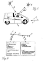
- Fig. 1 shows a schematic representation of an automobile 1, the for performing inventive, explained in more detail below Process variants is set up, and the implemented Communication structure.
- the automobile 1 includes various Data processing components, in particular an on-board computer with associated periphery, that of conventional construction are, unless otherwise stated below, and therefore in Fig. 1 is only symbolically represented by a notebook 2 are.
- the on-board data processing electronics 2 include in particular next to the actual on-board or vehicle computer Route guidance system with associated location aids and an on-board sensor system for recording measured values via attributes, i.e. route-related Further information.
- the locating means are given in usual (D-) GPS signals from corresponding satellites 3 via an associated unidirectional satellite communication channel 4.
- a bidirectional communication channel 5 e.g. can be a satellite or GSM communication channel
- the on-board sensor system mentioned detects instantaneous values given terrain / traffic attributes, such as with an arrow E symbolized, which is then used to update a data processing Traffic network map, in the present example a digital road map can be used.
- the digital road map can be in the on-board electronics 2 of the Vehicle 1 itself or in a related to it Central or another vehicle can be implemented.
- the vehicle 1 forms a test vehicle with which Continuous measurement data about the current vehicle position while driving and related terrain and traffic attributes won and to update the digital accordingly Road map can be used.
- the ongoing in this way The on-board electronics will then keep the digital road map up to date 2 used to provide predictive information about the terrain and traffic characteristics of the front of the vehicle 1 lying section of the route as vehicle guidance-relevant information provide as symbolized by an arrow A.
- the procedure according to the invention is characterized by suitable use of hardware components common in modern vehicles can be realized, practically any such vehicle as a test vehicle serve. Therefore, the collection and use of the road network information and the additional attributes are autonomous to the vehicle, i.e. only in your own vehicle with no exchange of information other vehicles or a control center. A large number of test vehicles improves the degree of update of the digital Map. On the other hand, those obtained in different vehicles Information also through mutual exchange or Transmission to the head office can be merged across the board.
- conventional telematics techniques using the mentioned Communication channels can display the current data of the Route network card for all system participants, i.e. everyone involved Vehicles and, if necessary, associated central offices be put. For example, the collection of currently in attribute data recorded in various vehicles be provided in a central, which depends on it centrally a data processing-supported route network map held by her updated and the connected vehicles the current Provides card data.
- Attributes include, in particular, geographical ones Peculiarities of the road network provided, namely with regard to the geographical coordinates including altitude, i.e. the Gradient. It is not only the occurrence of incline or Slopes and curves per se in the digital Card registered, but also its strength, e.g. in the form of the recorded value for the slope or for the curve radius. So can in particular be a quasi continuous attribution of the Road network with the road gradient and curve values be provided.
- attributes stored in a precise location are taken into account be like speed attributes over a typical medium vehicle speed or a speed limit with specification of a maximum or minimum speed, typical road sign attributes, such as when entering a town, a freeway start, a motor road, a priority road etc., typical prohibition sign attributes, such as above a ban on overtaking, a prohibited passage or a ban on certain vehicles such as Motorcycles or trucks, so-called POI (point of interest) attributes, such as via breakdown assistance, First aid, a police station, a hotel, a rest area or a gas station, restriction attributes, e.g.
- a maximum Headroom a maximum vehicle weight or one time limit
- direction of travel attributes via Restrictions on the permitted directions of travel and in particular also traffic situation attributes over the expected average Traffic situation or traffic condition, such as free traffic, brisk Traffic, heavy traffic, rush hour, stop & go traffic etc.
- these attributes can also be time-based as required can be recorded and stored in the digital map, i.e. that for the same street location at different times different values for the respective attribute are kept on the map become. This is especially true for the traffic attributes important, whose values fluctuate periodically may be subject to.
- the attributes are preferred also directional, i.e. are different for the same street location Values of the same attribute for the different ones Driving directions possible.
- Each at a specific point P recorded attribute values can then together with the location specification for this waypoint P, i.e. with him in the trail network identifying data in the form of its geographic coordinates possibly supplemented by a unique identifier in the digital Card can be saved.
- the location information belonging to the attributes is given in an analogous manner learned from the map, but not fixed in place, to avoid an acquired attribute due to a position measurement error assigned an incorrect attribute position becomes. Again, this is provided with a suitable, conventional one statistical procedures from all to a given Attribute known positions within a specified tolerance to determine a valid, relativized position value and assign the attribute to the relevant position.
- a suitable, conventional one statistical procedures from all to a given Attribute known positions within a specified tolerance to determine a valid, relativized position value and assign the attribute to the relevant position.
- the map update preferably also includes the measure that at least some of the attributes in the map are not held indefinitely assigned to a specific position become.
- the map thus updated takes into account For example, hiking construction sites where one at a certain point in time recognized and learned as an attribute Route restriction exists at a later date canceled or shifted on the route.
- location and attribute data regardless of the statistical method of learning only be deployed to an application if it has one have a predefined level of trust.
- the level of trust gives the reliability of the attribute recognition, i.e.
- the entire basic graph ie the traffic network that can be driven on
- the desired attributes can be assigned to it for the first time to the meter, using the method according to the invention.
- the attributes and the base graph can be corrected by saved deviations. In this way, the learning map can learn new intersections, bypasses etc.
- the card which is always kept up to date in this way, can be made available to all vehicles involved in the system, either directly or via a control center, or can be used locally 2 illustrates, after entering the vehicle position determined by the locating means, for example in the form of geographic coordinates, the stored values of corresponding attributes can be read out, and preferably not only the attributes stored for this location itself, but also those within a predeterminable look-ahead area in Attributes contained in front of the vehicle The latter measure makes it possible to provide information for predictive vehicle guidance.
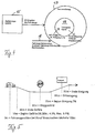
- FIG. 3 The typical sequence of an attribution process is in FIG. 3 illustrated.
- the right drawing shows a section of the navigable road network, the left field contains in one Function block exemplary data of a specific attribution.
- An example is the driving on a dashed line Circuit 10 accepted.
- the vehicle position is continuously updated using a GPS reading and a subsequent one Map matching determined.
- Map matching determined.
- the GPS measured values along the circuit 10, which are subject to measurement errors may differ slightly from the real vehicle position and shown in Fig. 3 by way of example with a dotted line 11 are on the network of routes available in the digital map pictured.
- the location coordinate measured values together with the vehicle mileage on the digital road map updating System part passed, from which a fan circle 12 forms, which come into question for the measured vehicle position Contains road edges.
- the card-learning system part is determined then with map matching or a suitable conventional one Coupling algorithm that road edge within the catch circle 12, the actual route section traveled should match and thus close irrelevant road edges as far as possible. Then based on several successive Position determination the direction of travel on the determined Street edge determined.
- the membership is an example in FIG. 3 the current vehicle position to an edge with Identity number 4711 and a first direction of travel (direction 1) accepted. If it is a time-saving attribute the current time is also taken into account.
- the current attribute value for the card current vehicle position recorded in parallel to the vehicle position determination for each in the Attribute to be saved.
- An example is in 3 the determination of a slope value of 6.3% for the attribute "Gradient course" reproduced. From the recorded attribute value then becomes a corresponding one or one of these and previous attribute values recorded here statistically derived, new attribute value determined and in the digital map assigned to the determined position.
- the energy consumption optimizer Forward-looking vehicle guidance information generated with which the driver or an autonomous vehicle guidance system the driving style in time at the upcoming Route can adjust so that energy consumption is kept as low as possible for the journey. In particular can therefore take turns, as well as up and down gradients, but also other driving impairments in good time consumption-reducing vehicle control measures are initiated.
- the consumption assistant system part 13 contains, in addition to other, conventional components, such as those readily apparent to a person skilled in the art from the following description of the mode of operation of the consumption assistant 13, in particular also, as mentioned, an adaptable, updatable card 14 of the type described above Position measuring device or a navigation system 15, the consumption assistant 13 receives the required vehicle position information. Furthermore, the consumption assistant 13 receives current attribute values 16 for the attributes of the card 16 in the form of values recorded by the relevant sensor system, which are each supplied via data bus lines. This includes the possibility of optical recognition by means of an image recording and image evaluation system, also referred to as "computer vision". With the recorded data, the core functionality learning card ", which may update the card 14 from the consumption assistant 13 or another system part.
- the learning card 14 has a look-ahead functionality, which means that for a given apron area, in present example approx. 100m, in the direction of travel in front of the vehicle those within this area for the street edge being traveled stored attribute values can be provided, in particular also the route.
- apron area in present example approx. 100m
- the thereby available Information about the characteristics of the terrain ahead the consumption assistant 13 then uses to generate predictive, energy-saving vehicle control measures, such as braking, acceleration and / or steering measures.
- Fig. 5 shows a concrete example of an application of such Preview process by the consumption assistant 13.
- the consumption assistant receives from the learnable road map 14 13 exemplary the information that measured a descent from the current vehicle position after 10m begins, which ends after another 20m and an average Gradient of 5%, a minimum gradient of 4.3% and a maximum Slope of 5.9% has a stop sign 50m in front of the vehicle stands and a slope begins 75m in front of the vehicle, which is 17m long and has a gradient of 7%, where 85m in front of the vehicle there is an entrance sign, which is known also represents a speed limit.
- the consumption assistant 13 is in the Able to generate predictive vehicle control measures with the help of this route section with as little as possible Energy consumption can be covered.
- the consumption assistant 13 shortly before reaching on the downhill slope or before reaching the stop sign for the accelerator pedal return and before reaching the slope in time, smooth acceleration taking into account that by entering the town prompt the following speed limit or this initiate.
- the consumption assistant 13 can Preparing a curve based on its radius of curvature prompt for an appropriate accelerator pedal retraction or braking or initiate this.
- the vehicle control information provided by the consumption assistant 13 can serve as driving instructions for the driver and in this case they will be displayed appropriately.
- vehicle management measures generated by the consumption assistant 13 for autonomous management with optimized consumption of the vehicle. It is understood that the expansion of the look-ahead area any desired Can have value or can be selected depending on the situation can be e.g. speed-dependent for higher driving speeds larger than for lower speeds.
- the consumption assistant for the determination of energy consumption-optimal travel routes to one Be designed destination reads from the digital Map 14 shows the values of the consumption-related attributes for the relevant route network area between the vehicle start location and the destination and determined based on this attribute data a route using a conventional route search method with the lowest possible energy consumption to the destination.
- Updatable road map 14 also a non-learning road map can be used for the consumption assistant 13, which the required attribute data relevant to energy consumption as in advance e.g. stored on the basis of test drives, not contains continuously updated information.
- vehicle type-specific attribute data is also stored stored in it and to generate more specific vehicle type Vehicle guidance information used to, for example the use of traffic routes by special vehicles, such as commercial vehicles, especially dangerous goods, on certain Prevent times of day or on certain days of the week.
- the upgradeable road network map serve to implement an intelligent cruise control, which is always the maximum permitted speed on the traffic Set route based on vehicle type and, if necessary, time-dependent.
Applications Claiming Priority (2)
| Application Number | Priority Date | Filing Date | Title |
|---|---|---|---|
| DE19916967 | 1999-04-15 | ||
| DE19916967A DE19916967C1 (de) | 1999-04-15 | 1999-04-15 | Verfahren zur Aktualisierung einer Verkehrswegenetzkarte und kartengestütztes Verfahren zur Fahrzeugführungsinformationserzeugung |
Publications (2)
| Publication Number | Publication Date |
|---|---|
| EP1045224A2 true EP1045224A2 (fr) | 2000-10-18 |
| EP1045224A3 EP1045224A3 (fr) | 2001-10-24 |
Family
ID=7904618
Family Applications (1)
| Application Number | Title | Priority Date | Filing Date |
|---|---|---|---|
| EP00104981A Withdrawn EP1045224A3 (fr) | 1999-04-15 | 2000-03-09 | Méthode pour la mise à jour d'une carte routière et méthode pour créer de l'information de guidage de véhicule basée sur la carte |
Country Status (4)
| Country | Link |
|---|---|
| EP (1) | EP1045224A3 (fr) |
| JP (1) | JP2000321081A (fr) |
| AU (1) | AU755096B2 (fr) |
| DE (1) | DE19916967C1 (fr) |
Cited By (33)
| Publication number | Priority date | Publication date | Assignee | Title |
|---|---|---|---|---|
| WO2002003351A1 (fr) * | 2000-07-04 | 2002-01-10 | Daimlerchrysler Ag | Systeme d'assistance destine a la selection de parcours |
| EP1205731A1 (fr) * | 2000-11-07 | 2002-05-15 | BECKER GmbH | Procédé de réalisation d'une carte de navigation et carte de navigation |
| EP1300654A1 (fr) * | 2001-09-28 | 2003-04-09 | Robert Bosch Gmbh | Méthode et dispositif pour déterminer des données cartographiques |
| EP1321742A3 (fr) * | 2001-12-18 | 2003-07-02 | ZF Lemförder Metallwaren AG | Méthode et dispositif de généreration et mise à jour d'une carte routière et/ou d'une carte des conditions routières |
| EP1505369A1 (fr) * | 2003-08-08 | 2005-02-09 | Harman/Becker Automotive Systems GmbH | Procédé et système pour fournir des données de trafic à un conducteur d'un véhicule |
| DE10114412C5 (de) * | 2001-03-23 | 2006-07-06 | Audi Ag | Verfahren zur Erzeugung einer Straßennetzkarte sowie Verfahren und Vorrichtung zur Steuerung von Fahrzeugsystemen in einem Fahrzeug |
| US7089162B2 (en) | 2001-11-07 | 2006-08-08 | Harman International Industries, Incorporated | Navigation map creation system |
| EP1826737A2 (fr) * | 2006-02-28 | 2007-08-29 | Bayerische Motoren Werke Aktiengesellschaft | Procédé destiné à l'émission d'une information d'alerte dans un véhicule |
| DE10057796B4 (de) * | 2000-11-22 | 2007-12-27 | Daimlerchrysler Ag | Verfahren zur fahrzeugindividuellen Verkehrszustandsprognose |
| DE10062856B4 (de) * | 2000-12-16 | 2008-01-10 | Daimlerchrysler Ag | Verfahren zur fahrzeugindividuellen Verkehrsprognose |
| WO2009027122A1 (fr) * | 2007-08-25 | 2009-03-05 | Continental Teves Ag & Co. Ohg | Unité de mise à jour et procédé de mise à jour d'une carte numérique |
| WO2009030520A1 (fr) * | 2007-08-29 | 2009-03-12 | Continental Teves Ag & Co. Ohg | Actualisation dynamique de cartes numériques |
| WO2010069380A1 (fr) * | 2008-12-18 | 2010-06-24 | Tele Atlas B.V. | Procédé et appareil pour mettre à jour des données cartographiques |
| WO2010074668A1 (fr) * | 2008-12-22 | 2010-07-01 | Tele Atlas North America, Inc. | Procédés, dispositifs et bases de données de cartes pour la navigation verte ou « green routing » |
| WO2010081540A1 (fr) * | 2009-01-14 | 2010-07-22 | Tomtom International B.V. | Améliorations relatives à un appareil de navigation utilisé à bord d'un véhicule |
| DE102009008745A1 (de) * | 2009-02-12 | 2010-08-19 | Volkswagen Ag | Verfahren und System zur automatischen Verkehrsführung |
| ITRM20090251A1 (it) * | 2009-05-19 | 2010-11-20 | Aci Consult Cnp S P A | Dispositivo compatto ad alto rendimento applicabile ad ogni tipo di mezzo adibito al trasporto trasporto merci trasporto pubblico locale tpl trasporto rifiuti polizia locale dcc finalizzato alla acquisizione di dati ed immagini delle infrastrutture s |
| DE102006004130B4 (de) * | 2006-01-27 | 2012-02-16 | Audi Ag | Verfahren zur Bestimmung eines zukünftigen Straßenverlaufs durch Kommunikaiton zwischen Kraftfahrzeugen |
| CN102521972A (zh) * | 2011-12-27 | 2012-06-27 | 北京世纪高通科技有限公司 | 路链信息差分方法及装置 |
| CN101275841B (zh) * | 2007-03-30 | 2012-09-19 | 爱信艾达株式会社 | 地物信息收集装置及地物信息收集方法 |
| WO2013056767A1 (fr) * | 2011-10-18 | 2013-04-25 | Audi Ag | Procédé pour déterminer des informations de parcours à jour sur une carte numérique |
| CN104751665A (zh) * | 2013-12-26 | 2015-07-01 | 上海博泰悦臻网络技术服务有限公司 | 危险路段分析方法及装置 |
| US9321441B1 (en) | 2014-11-19 | 2016-04-26 | Robert Bosch Gmbh | GPS based learned control event prediction |
| WO2016116276A1 (fr) * | 2015-01-24 | 2016-07-28 | Audi Ag | Procédé de fonctionnement d'un véhicule automobile et véhicule automobile |
| CN106458218A (zh) * | 2014-03-04 | 2017-02-22 | 谷歌公司 | 报告并且与其它车辆共享道路事件数据 |
| WO2017041963A1 (fr) * | 2015-09-07 | 2017-03-16 | Bayerische Motoren Werke Aktiengesellschaft | Procédé d'optimisation du degré de remplissage d'un réservoir sous pression cryogénique d'un véhicule automobile, pouvant être atteint lors d'un réapprovisionnement |
| US9775128B2 (en) | 2016-01-21 | 2017-09-26 | Ford Global Technologies, Llc | Vehicular connectivity map |
| EP3108209A4 (fr) * | 2014-02-18 | 2017-10-25 | Scania CV AB | Construction de carte dans un véhicule |
| EP3256815A1 (fr) * | 2014-12-05 | 2017-12-20 | Apple Inc. | Système de navigation autonome |
| CN107667397A (zh) * | 2015-05-20 | 2018-02-06 | 德尔福技术有限公司 | 用于自动更新由多个自动化车辆使用的路线数据的系统 |
| CN108369774A (zh) * | 2015-12-08 | 2018-08-03 | 奥迪股份公司 | 用于在即将进行的超车动作方面辅助机动车的驾驶员的方法以及机动车 |
| WO2019007602A1 (fr) * | 2017-07-07 | 2019-01-10 | Robert Bosch Gmbh | Procédé pour faire fonctionner un véhicule très automatisé, en particulier un véhicule fortement automatisé |
| US10699571B2 (en) | 2017-12-04 | 2020-06-30 | Ford Global Technologies, Llc | High definition 3D mapping |
Families Citing this family (77)
| Publication number | Priority date | Publication date | Assignee | Title |
|---|---|---|---|---|
| DE10034109C1 (de) * | 2000-07-13 | 2001-09-06 | Juergen W Mueller | Verfahren zur Verknüpfung geographischer und kommerzieller Daten sowie deren Bereitstellung |
| DE10043578B4 (de) * | 2000-09-05 | 2011-09-22 | Robert Bosch Gmbh | Verfahren zur Routenberechnung |
| DE10101982A1 (de) * | 2001-01-18 | 2002-07-25 | Bayerische Motoren Werke Ag | Verfahren zur Fahrdynamikregelung |
| JP2003021525A (ja) * | 2001-07-05 | 2003-01-24 | Zenrin Co Ltd | 経路探索用電子地図データ |
| DE10162866A1 (de) * | 2001-12-20 | 2003-07-10 | Zahnradfabrik Friedrichshafen | Führungssystem für ein Kraftfahrzeug |
| DE10202756A1 (de) * | 2002-01-25 | 2003-08-07 | Daimler Chrysler Ag | Digitale Karte mit Temperaturdaten |
| DE10204496A1 (de) | 2002-02-04 | 2003-08-21 | Msa Auer Gmbh | Vorrichtung zur Dosierung gas- und/oder dampfförmiger Stoffe |
| DE10207488B4 (de) * | 2002-02-22 | 2006-02-16 | Daimlerchrysler Ag | Verfahren zur Informationserzeugung in einem Fahrzeug |
| DE10209173C1 (de) * | 2002-03-01 | 2003-04-24 | Daimler Chrysler Ag | Verfahren zum Aktualisieren von Kartendaten und Navigationssystem |
| DE10258470B4 (de) * | 2002-12-09 | 2012-01-19 | Volkswagen Ag | Navigationseinrichtung für Kraftfahrzeuge |
| DE10260038A1 (de) * | 2002-12-19 | 2004-07-15 | Steinröx, Leo | Verfahren und Vorrichtung zur Geschwindigkeitsregulierung von sich bewegenden Fahrzeugen |
| DE10325424A1 (de) * | 2003-06-05 | 2004-12-23 | Volkswagen Ag | Verfahren und Einrichtung zur Zielführung eines Fahrzeuges |
| JP2005038381A (ja) | 2003-06-30 | 2005-02-10 | Toshiba Corp | データ分析装置、データ分析プログラム及び携帯端末 |
| DE102005045049A1 (de) * | 2005-09-21 | 2007-03-22 | Martin Neuke | Navigationseinrichtung für Fahrzeuge zur Unterstützung einer energieoptimierten Fahrweise |
| JP5075331B2 (ja) * | 2005-09-30 | 2012-11-21 | アイシン・エィ・ダブリュ株式会社 | 地図データベース生成システム |
| DE102005049458A1 (de) * | 2005-10-15 | 2007-04-26 | Daimlerchrysler Ag | Verfahren und Vorrichtung zur Verbrauchsreduzierung in einem Fahrzeug |
| CN1967523B (zh) * | 2005-11-15 | 2010-07-28 | 日电(中国)有限公司 | 路况信息查询系统及路况信息查询方法 |
| CN1967524B (zh) * | 2005-11-15 | 2010-07-21 | 日电(中国)有限公司 | 路况信息收集和查询系统及其方法 |
| DE102006001818B4 (de) * | 2006-01-13 | 2017-02-02 | Man Truck & Bus Ag | Verfahren und Vorrichtung zur Fahrerunterstützung beim Fahrbetrieb eines Nutzfahrzeugs |
| KR101136684B1 (ko) | 2006-06-09 | 2012-04-23 | 도요타지도샤가부시키가이샤 | 데이터 갱신 시스템, 네비게이션 장치, 서버 장치, 및 데이터 갱신 방법 |
| JP4910510B2 (ja) | 2006-06-30 | 2012-04-04 | 株式会社デンソー | 制御用情報記憶装置及びプログラム |
| DE102007033664A1 (de) * | 2006-07-20 | 2008-03-27 | Continental Teves Ag & Co. Ohg | Verfahren und Vorrichtung zur Gefahrenwarnung und Unfallvermeidung für Kraftfahrzeuge |
| EP1890110A3 (fr) * | 2006-08-18 | 2013-04-24 | Volkswagen Aktiengesellschaft | Procédé de détermination d'une stratégie de conduite optimale d'un véhicule automobile et dispositif équipé de manière correspondante tout comme affichage associé ainsi que véhicule automobile associé |
| DE102007003387A1 (de) * | 2007-01-23 | 2008-07-31 | Michael Cloos | Verfahren und Datenverarbeitungssystem zum Anlegen eines Routenwegs und Verfahren zur Routenberechnung sowie Navigationssystem und Computerprogramm zur Durchführung der Verfahren |
| DE102007009639B4 (de) | 2007-02-26 | 2010-04-08 | Deutsches Zentrum für Luft- und Raumfahrt e.V. | Verfahren zur Ermittlung einer hochgenauen Position von Fahrwegen und/oder Objekten |
| JP4446201B2 (ja) * | 2007-03-30 | 2010-04-07 | アイシン・エィ・ダブリュ株式会社 | 画像認識装置及び画像認識方法 |
| US8155826B2 (en) | 2007-03-30 | 2012-04-10 | Aisin Aw Co., Ltd. | Vehicle behavior learning apparatuses, methods, and programs |
| JP4437556B2 (ja) | 2007-03-30 | 2010-03-24 | アイシン・エィ・ダブリュ株式会社 | 地物情報収集装置及び地物情報収集方法 |
| DE102007031329A1 (de) * | 2007-07-05 | 2009-01-08 | Continental Automotive Gmbh | Verfahren, Vorrichtung und Computerprogramm zum Betreiben eines Navigationssystems |
| WO2009027123A1 (fr) | 2007-08-25 | 2009-03-05 | Continental Teves Ag & Co. Ohg | Actualisation de cartes numériques et détermination de position |
| DE102008012654A1 (de) | 2007-08-29 | 2009-03-05 | Continental Teves Ag & Co. Ohg | Onlineerstellung einer digitalen Karte |
| JP4501983B2 (ja) | 2007-09-28 | 2010-07-14 | アイシン・エィ・ダブリュ株式会社 | 駐車支援システム、駐車支援方法、駐車支援プログラム |
| DE102007000971B4 (de) * | 2007-10-25 | 2013-05-08 | Siemens Aktiengesellschaft | Verfahren zur kollaborativen Pflege von Kartenmaterial für mobile Navigationsgeräte |
| DE102007056448A1 (de) | 2007-11-23 | 2009-05-28 | Dr. Ing. H.C. F. Porsche Aktiengesellschaft | Verfahren zur Information eines Fahrers eines Kraftfahrzeuges |
| DE102008012697A1 (de) * | 2007-12-12 | 2009-06-18 | Daimler Ag | Verfahren zum Betrieb eines Navigationssystems und Navigationssystem |
| KR101013906B1 (ko) * | 2007-12-18 | 2011-02-14 | 기아자동차주식회사 | 경제운전 안내 시스템 |
| JP4831434B2 (ja) | 2007-12-27 | 2011-12-07 | アイシン・エィ・ダブリュ株式会社 | 地物情報収集装置及び地物情報収集プログラム、並びに自車位置認識装置及びナビゲーション装置 |
| JP5257923B2 (ja) | 2008-01-31 | 2013-08-07 | 株式会社アドヴィックス | 車両の運動制御装置 |
| WO2009098071A1 (fr) | 2008-02-08 | 2009-08-13 | FKFS Forschungsinstitut für Kraftfahrwesen und Fahrzeugmotoren Stuttgart | Dispositif et procédé de fourniture d'informations concernant des situations de conduite |
| DE102009017731A1 (de) | 2008-04-30 | 2009-11-05 | Continental Teves Ag & Co. Ohg | Selbstlernende Karte auf Basis von Umfeldsensoren |
| US8626441B2 (en) | 2008-06-17 | 2014-01-07 | Agco Corporation | Methods and apparatus for using position/attitude information to enhance a vehicle guidance system |
| DE102008039950B4 (de) * | 2008-08-27 | 2015-04-02 | Man Truck & Bus Ag | Verfahren, Vorrichtung und Straßenkraftfahrzeug mit einer Vorrichtung zum Ermitteln eines Fahrprofils für Straßenkraftfahrzeuge |
| SG171701A1 (en) | 2008-12-29 | 2011-07-28 | Tomtom Int Bv | Navigation device & method |
| EP2208967A1 (fr) * | 2009-01-20 | 2010-07-21 | Alpine Electronics, Inc. | Système de navigation comprenant une fonction d'orientation routière et procédé de recherche d'itinéraires |
| DE102009001068A1 (de) * | 2009-02-23 | 2010-08-26 | Robert Bosch Gmbh | Verfahren zum Betreiben eines Informationssystems, Informationssystem und Speichermedium |
| DE102009015161A1 (de) * | 2009-03-26 | 2010-09-30 | Bayerische Motoren Werke Aktiengesellschaft | Verfahren zur Erzeugung von Soll-Vorgaben für mindestens einen einstellbaren Fahrzeugparameter |
| DE102010015342A1 (de) * | 2010-04-17 | 2011-10-20 | Albrecht Kretzschmar | Energie-Navigations-Karte |
| DE102010028671A1 (de) | 2010-05-06 | 2011-11-10 | Zf Friedrichshafen Ag | Verfahren zum Betreiben eines Antriebsstrangs |
| DE102010042065B4 (de) * | 2010-10-06 | 2022-12-08 | Robert Bosch Gmbh | Verfahren und Vorrichtung zum Ausgeben einer Empfehlung eines Ausrollen-Lassens des Fahrzeugs für ein Fahrerassistenzsystem des Fahrzeugs |
| JP5845616B2 (ja) * | 2011-04-20 | 2016-01-20 | 日産自動車株式会社 | 運転支援装置及び運転支援方法 |
| DE102011084633A1 (de) * | 2011-10-17 | 2013-04-18 | Robert Bosch Gmbh | Vorrichtung und Verfahren zum Erkennen von Fehlern in Streckendaten |
| DE102012004625A1 (de) * | 2012-03-06 | 2013-09-12 | Volkswagen Aktiengesellschaft | Verfahren und Vorrichtung zur Aktualisierung und Anpassung von Karteninformationen in einem Navigationssystem |
| JP5572184B2 (ja) * | 2012-07-17 | 2014-08-13 | 株式会社アドヴィックス | 車両の運動制御装置 |
| DE102013209729A1 (de) | 2013-05-24 | 2014-11-27 | Robert Bosch Gmbh | Fahrerassistenzsystem mit zusätzlichen Informationen zu einer Straßenkarte |
| DE102013107960B4 (de) * | 2013-07-25 | 2020-11-05 | Deutsches Zentrum für Luft- und Raumfahrt e.V. | Verfahren zur Aktualisierung einer Datenbasis sowie Einrichtung und Computerprogramm |
| US9465388B1 (en) | 2014-03-03 | 2016-10-11 | Google Inc. | Remote assistance for an autonomous vehicle in low confidence situations |
| US9720410B2 (en) | 2014-03-03 | 2017-08-01 | Waymo Llc | Remote assistance for autonomous vehicles in predetermined situations |
| JP6476557B2 (ja) * | 2014-03-07 | 2019-03-06 | 日産自動車株式会社 | 車両走行制御情報収集装置 |
| DE102014106014A1 (de) * | 2014-04-29 | 2015-10-29 | Dr. Ing. H.C. F. Porsche Aktiengesellschaft | Verfahren zum Erfassen der Straßenneigung |
| DE102014213107A1 (de) * | 2014-07-07 | 2016-01-07 | Robert Bosch Gmbh | Fahrzeugassistenzsystem |
| EP3197738B1 (fr) | 2014-09-26 | 2018-05-16 | Volvo Truck Corporation | Procédé mis en oeuvre par une unité de commande pour commander les flux d'énergie d'un véhicule |
| DE102015223825A1 (de) | 2015-12-01 | 2017-06-01 | Bayerische Motoren Werke Aktiengesellschaft | Navigationsdatenbank und Verfahren mit einer besseren Abschätzung der Zuverlässigkeit der Navigationsdaten |
| DE102016004656B4 (de) * | 2016-04-16 | 2023-03-23 | Audi Ag | Verfahren zum Ermitteln eines jeweiligen Kategoriewerts betreffend eine jeweilige Bewertungskategorie für Streckenabschnitte eines Straßennetzes |
| DE102016217653A1 (de) | 2016-09-15 | 2018-03-15 | Bayerische Motoren Werke Aktiengesellschaft | Verfahren und Datenverarbeitungsanlage zur Erzeugung von Kartendaten einer digitalen Karte |
| DE102016220249A1 (de) * | 2016-10-17 | 2018-04-19 | Robert Bosch Gmbh | Verfahren und System zur Lokalisierung eines Fahrzeugs |
| DE102016222049A1 (de) | 2016-11-10 | 2018-05-17 | Bayerische Motoren Werke Aktiengesellschaft | Bestimmung eines Erweiterungsobjekts einer digitalen Karte |
| DE102017204607A1 (de) | 2017-03-20 | 2018-09-20 | Bayerische Motoren Werke Aktiengesellschaft | Automatische und individuelle Adaption einer Verbrauchsinformation |
| DE102017205939A1 (de) * | 2017-04-06 | 2018-10-11 | Knorr-Bremse Systeme für Schienenfahrzeuge GmbH | Automatische Generierung von Infrastrukturdaten für ein Streckennetz |
| US10713940B2 (en) | 2017-10-31 | 2020-07-14 | Waymo Llc | Detecting and responding to traffic redirection for autonomous vehicles |
| US10401862B2 (en) | 2017-10-31 | 2019-09-03 | Waymo Llc | Semantic object clustering for autonomous vehicle decision making |
| DE102018204501B3 (de) | 2018-03-23 | 2019-07-04 | Continental Automotive Gmbh | System zur Erzeugung von Konfidenzwerten im Backend |
| DE102018204500A1 (de) * | 2018-03-23 | 2019-09-26 | Continental Automotive Gmbh | System zur Erzeugung von Konfidenzwerten im Backend |
| DE102018116036A1 (de) | 2018-07-03 | 2020-01-09 | Connaught Electronics Ltd. | Training eines tiefen konvolutionellen neuronalen Netzwerks für individuelle Routen |
| DE102018221708B4 (de) * | 2018-12-13 | 2021-03-18 | Volkswagen Aktiengesellschaft | Bestimmung einer weiteren Erprobungsroute während einer Erprobungsfahrt eines Fahrzeugs |
| DE102020105313A1 (de) | 2020-02-28 | 2021-09-02 | Bayerische Motoren Werke Aktiengesellschaft | Verfahren, Recheneinrichtung und System zum Kartographieren von Landmarken eines Straßennetzes in einer Straßenkarte |
| DE102020110659A1 (de) | 2020-04-20 | 2021-10-21 | Bayerische Motoren Werke Aktiengesellschaft | Betreiben eines Fahrzeugs sowie Fahrzeug und System |
| DE102020211363A1 (de) | 2020-09-10 | 2022-03-10 | Robert Bosch Gesellschaft mit beschränkter Haftung | Verfahren und Vorrichtung zum Erstellen, Bereitstellen und Verwenden einer Gesamtkarte |
Citations (2)
| Publication number | Priority date | Publication date | Assignee | Title |
|---|---|---|---|---|
| DE19604084A1 (de) * | 1995-03-23 | 1996-10-02 | Deutsche Telekom Mobil | Verfahren und Einrichtung zur Ermittlung von Dynamischen Verkehrsinformationen |
| DE19701370A1 (de) * | 1996-01-27 | 1997-07-31 | Volkswagen Ag | Verfahren zur Erweiterung von abgespeicherten Datensätzen eines Straßennetzes |
Family Cites Families (15)
| Publication number | Priority date | Publication date | Assignee | Title |
|---|---|---|---|---|
| US440918A (en) * | 1890-11-18 | Saw-gin | ||
| US4055061A (en) * | 1976-04-26 | 1977-10-25 | Applied Power, Inc. | Apparatus for reforming and straightening vehicles |
| DE2922804C2 (de) * | 1979-06-05 | 1986-09-25 | Applied Power, Inc., Milwaukee, Wis. | Meßbrücke |
| DE3700552B4 (de) * | 1987-01-10 | 2005-06-02 | Robert Bosch Gmbh | Verfahren zur Ausgabe von Wegeinformationen für Fahrer von Landfahrzeugen und Informationsausgabesystem |
| US4891761A (en) * | 1988-03-31 | 1990-01-02 | Mets, Inc. | Method for accurately updating positional information provided on a digital map |
| DE4344369C2 (de) * | 1993-12-24 | 1997-12-11 | Daimler Benz Ag | Verbrauchsorientierte Fahrleistungsbegrenzung eines Fahrzeugantriebs |
| US5661650A (en) * | 1994-02-23 | 1997-08-26 | Honda Giken Kogyo Kabushiki Kaisha | System for controlling a vehicle relative to a judged shape of a travel road |
| DE4408038C2 (de) * | 1994-03-10 | 1997-09-18 | Porsche Ag | Abstimmvorrichtung für Karosserie- und/oder Ausstattungsteile von neuen Fahrzeugen |
| JP3203976B2 (ja) * | 1994-09-05 | 2001-09-04 | 日産自動車株式会社 | 車両用駆動力制御装置 |
| DE19525291C1 (de) * | 1995-07-03 | 1996-12-19 | Mannesmann Ag | Verfahren und Vorrichtung zur Aktualisierung von digitalen Straßenkarten |
| DE19605458C1 (de) * | 1996-02-14 | 1997-09-04 | Hyundai Motor Co Ltd | Fahrzeugnavigationssystem und Verfahren zum Auswählen einer Fahrtstrecke entsprechend dem Kraftstoffverbrauch |
| DE19620465A1 (de) * | 1996-05-21 | 1998-01-08 | Bayerische Motoren Werke Ag | Vorrichtung zur Abstimmung von Fahrzeugteilen |
| WO1998023918A1 (fr) * | 1996-11-25 | 1998-06-04 | Toyota Jidosha Kabushiki Kaisha | Dispositif de navigation pour vehicule et preparation de donnees de configuration de la route utilisees avec ce dispositif |
| DE19650844C2 (de) * | 1996-11-27 | 2003-09-25 | Mannesmann Ag | Verfahren zur Ermittlung von Fahrtroutendaten |
| DE19742414C2 (de) * | 1997-09-22 | 2000-06-29 | Mannesmann Ag | Verfahren und Endgerät zur Aktualisierung und/oder Ergänzung einer digitalen Straßenkarte eines Verkehrsnetzes |
-
1999
- 1999-04-15 DE DE19916967A patent/DE19916967C1/de not_active Expired - Fee Related
-
2000
- 2000-03-09 EP EP00104981A patent/EP1045224A3/fr not_active Withdrawn
- 2000-04-10 AU AU27641/00A patent/AU755096B2/en not_active Ceased
- 2000-04-14 JP JP2000113429A patent/JP2000321081A/ja active Pending
Patent Citations (2)
| Publication number | Priority date | Publication date | Assignee | Title |
|---|---|---|---|---|
| DE19604084A1 (de) * | 1995-03-23 | 1996-10-02 | Deutsche Telekom Mobil | Verfahren und Einrichtung zur Ermittlung von Dynamischen Verkehrsinformationen |
| DE19701370A1 (de) * | 1996-01-27 | 1997-07-31 | Volkswagen Ag | Verfahren zur Erweiterung von abgespeicherten Datensätzen eines Straßennetzes |
Cited By (55)
| Publication number | Priority date | Publication date | Assignee | Title |
|---|---|---|---|---|
| WO2002003351A1 (fr) * | 2000-07-04 | 2002-01-10 | Daimlerchrysler Ag | Systeme d'assistance destine a la selection de parcours |
| EP1205731A1 (fr) * | 2000-11-07 | 2002-05-15 | BECKER GmbH | Procédé de réalisation d'une carte de navigation et carte de navigation |
| US7324895B2 (en) | 2000-11-07 | 2008-01-29 | Harman Becker Automotive Systems Gmbh | Apparatus for creating a navigation map |
| DE10057796B4 (de) * | 2000-11-22 | 2007-12-27 | Daimlerchrysler Ag | Verfahren zur fahrzeugindividuellen Verkehrszustandsprognose |
| DE10062856B4 (de) * | 2000-12-16 | 2008-01-10 | Daimlerchrysler Ag | Verfahren zur fahrzeugindividuellen Verkehrsprognose |
| DE10114412C5 (de) * | 2001-03-23 | 2006-07-06 | Audi Ag | Verfahren zur Erzeugung einer Straßennetzkarte sowie Verfahren und Vorrichtung zur Steuerung von Fahrzeugsystemen in einem Fahrzeug |
| EP1300654A1 (fr) * | 2001-09-28 | 2003-04-09 | Robert Bosch Gmbh | Méthode et dispositif pour déterminer des données cartographiques |
| US7089162B2 (en) | 2001-11-07 | 2006-08-08 | Harman International Industries, Incorporated | Navigation map creation system |
| EP1321742A3 (fr) * | 2001-12-18 | 2003-07-02 | ZF Lemförder Metallwaren AG | Méthode et dispositif de généreration et mise à jour d'une carte routière et/ou d'une carte des conditions routières |
| US7822538B2 (en) | 2003-08-08 | 2010-10-26 | Harman Becker Automotive Systems Gmbh | System for communicating traffic data |
| EP1505369A1 (fr) * | 2003-08-08 | 2005-02-09 | Harman/Becker Automotive Systems GmbH | Procédé et système pour fournir des données de trafic à un conducteur d'un véhicule |
| DE102006004130B4 (de) * | 2006-01-27 | 2012-02-16 | Audi Ag | Verfahren zur Bestimmung eines zukünftigen Straßenverlaufs durch Kommunikaiton zwischen Kraftfahrzeugen |
| US7728737B2 (en) | 2006-02-28 | 2010-06-01 | Bayerische Motoren Werke Aktiengesellschaft | Systems and methods for output of information messages in a vehicle |
| EP1826737A3 (fr) * | 2006-02-28 | 2009-11-25 | Bayerische Motoren Werke Aktiengesellschaft | Procédé destiné à l'émission d'une information d'alerte dans un véhicule |
| EP1826737A2 (fr) * | 2006-02-28 | 2007-08-29 | Bayerische Motoren Werke Aktiengesellschaft | Procédé destiné à l'émission d'une information d'alerte dans un véhicule |
| CN101275841B (zh) * | 2007-03-30 | 2012-09-19 | 爱信艾达株式会社 | 地物信息收集装置及地物信息收集方法 |
| WO2009027122A1 (fr) * | 2007-08-25 | 2009-03-05 | Continental Teves Ag & Co. Ohg | Unité de mise à jour et procédé de mise à jour d'une carte numérique |
| WO2009030520A1 (fr) * | 2007-08-29 | 2009-03-12 | Continental Teves Ag & Co. Ohg | Actualisation dynamique de cartes numériques |
| WO2010069380A1 (fr) * | 2008-12-18 | 2010-06-24 | Tele Atlas B.V. | Procédé et appareil pour mettre à jour des données cartographiques |
| CN102187178B (zh) * | 2008-12-22 | 2015-11-25 | 电子地图北美公司 | 用于绿色路线选择的方法、装置和地图数据库 |
| WO2010074668A1 (fr) * | 2008-12-22 | 2010-07-01 | Tele Atlas North America, Inc. | Procédés, dispositifs et bases de données de cartes pour la navigation verte ou « green routing » |
| RU2523192C2 (ru) * | 2008-12-22 | 2014-07-20 | Теле Атлас Норт Америка, Инк. | Способы, устройства и картографические базы данных для прокладки "зеленого" маршрута |
| US10175058B2 (en) | 2008-12-22 | 2019-01-08 | Tomtom Global Content B.V. | Methods, devices and map databases for green routing |
| CN102187178A (zh) * | 2008-12-22 | 2011-09-14 | 电子地图北美公司 | 用于绿色路线选择的方法、装置和地图数据库 |
| WO2010081540A1 (fr) * | 2009-01-14 | 2010-07-22 | Tomtom International B.V. | Améliorations relatives à un appareil de navigation utilisé à bord d'un véhicule |
| CN102037319A (zh) * | 2009-01-14 | 2011-04-27 | 通腾科技股份有限公司 | 与交通工具内使用的导航设备相关的改进 |
| US9002635B2 (en) | 2009-01-14 | 2015-04-07 | Tomtom International B.V. | Navigation apparatus used-in vehicle |
| CN102037319B (zh) * | 2009-01-14 | 2015-11-25 | 通腾科技股份有限公司 | 与交通工具内使用的导航设备相关的改进 |
| DE102009008745B4 (de) * | 2009-02-12 | 2020-12-24 | Volkswagen Ag | Verfahren und System zur automatischen Verkehrsführung |
| DE102009008745A1 (de) * | 2009-02-12 | 2010-08-19 | Volkswagen Ag | Verfahren und System zur automatischen Verkehrsführung |
| ITRM20090251A1 (it) * | 2009-05-19 | 2010-11-20 | Aci Consult Cnp S P A | Dispositivo compatto ad alto rendimento applicabile ad ogni tipo di mezzo adibito al trasporto trasporto merci trasporto pubblico locale tpl trasporto rifiuti polizia locale dcc finalizzato alla acquisizione di dati ed immagini delle infrastrutture s |
| WO2013056767A1 (fr) * | 2011-10-18 | 2013-04-25 | Audi Ag | Procédé pour déterminer des informations de parcours à jour sur une carte numérique |
| CN102521972B (zh) * | 2011-12-27 | 2014-02-26 | 北京世纪高通科技有限公司 | 路链信息差分方法及装置 |
| CN102521972A (zh) * | 2011-12-27 | 2012-06-27 | 北京世纪高通科技有限公司 | 路链信息差分方法及装置 |
| CN104751665A (zh) * | 2013-12-26 | 2015-07-01 | 上海博泰悦臻网络技术服务有限公司 | 危险路段分析方法及装置 |
| EP3108209A4 (fr) * | 2014-02-18 | 2017-10-25 | Scania CV AB | Construction de carte dans un véhicule |
| CN106458218A (zh) * | 2014-03-04 | 2017-02-22 | 谷歌公司 | 报告并且与其它车辆共享道路事件数据 |
| US9321441B1 (en) | 2014-11-19 | 2016-04-26 | Robert Bosch Gmbh | GPS based learned control event prediction |
| WO2016081331A1 (fr) * | 2014-11-19 | 2016-05-26 | Robert Bosch Gmbh | Prévision d'événement de commande appris à base de gps |
| CN107110657A (zh) * | 2014-11-19 | 2017-08-29 | 罗伯特·博世有限公司 | 基于gps的经学习的控制事件预测 |
| EP3256815A1 (fr) * | 2014-12-05 | 2017-12-20 | Apple Inc. | Système de navigation autonome |
| WO2016116276A1 (fr) * | 2015-01-24 | 2016-07-28 | Audi Ag | Procédé de fonctionnement d'un véhicule automobile et véhicule automobile |
| US10513262B2 (en) | 2015-01-24 | 2019-12-24 | Audi Ag | Method for operating a motor vehicle and motor vehicle |
| CN107667397A (zh) * | 2015-05-20 | 2018-02-06 | 德尔福技术有限公司 | 用于自动更新由多个自动化车辆使用的路线数据的系统 |
| EP3298467A4 (fr) * | 2015-05-20 | 2019-01-23 | Aptiv Technologies Limited | Système de mise à jour automatique des données d'itinéraire utilisées par une pluralité de véhicules à conduite automatique |
| WO2017041963A1 (fr) * | 2015-09-07 | 2017-03-16 | Bayerische Motoren Werke Aktiengesellschaft | Procédé d'optimisation du degré de remplissage d'un réservoir sous pression cryogénique d'un véhicule automobile, pouvant être atteint lors d'un réapprovisionnement |
| CN108369774A (zh) * | 2015-12-08 | 2018-08-03 | 奥迪股份公司 | 用于在即将进行的超车动作方面辅助机动车的驾驶员的方法以及机动车 |
| US10643470B2 (en) | 2015-12-08 | 2020-05-05 | Audi Ag | Method for assisting a driver of a motor vehicle with respect to an imminent overtaking maneuver, and motor vehicle |
| EP3387632B1 (fr) * | 2015-12-08 | 2021-01-06 | Audi AG | Procédé pour assister le conducteur d'un véhicule automobile concernant une manoeuvre de dépassement imminente et véhilcule automobile |
| US9775128B2 (en) | 2016-01-21 | 2017-09-26 | Ford Global Technologies, Llc | Vehicular connectivity map |
| WO2019007602A1 (fr) * | 2017-07-07 | 2019-01-10 | Robert Bosch Gmbh | Procédé pour faire fonctionner un véhicule très automatisé, en particulier un véhicule fortement automatisé |
| CN110869865A (zh) * | 2017-07-07 | 2020-03-06 | 罗伯特·博世有限公司 | 用于运行较高程度自动化的车辆(haf)、尤其高度自动化车辆的方法 |
| US11934197B2 (en) | 2017-07-07 | 2024-03-19 | Robert Bosch Gmbh | Method for operating a higher-level automated vehicle (HAV), in particular a highly automated vehicle |
| CN110869865B (zh) * | 2017-07-07 | 2024-05-07 | 罗伯特·博世有限公司 | 用于运行较高程度自动化的车辆(haf)、尤其高度自动化车辆的方法 |
| US10699571B2 (en) | 2017-12-04 | 2020-06-30 | Ford Global Technologies, Llc | High definition 3D mapping |
Also Published As
| Publication number | Publication date |
|---|---|
| JP2000321081A (ja) | 2000-11-24 |
| AU2764100A (en) | 2000-11-30 |
| AU755096B2 (en) | 2002-12-05 |
| DE19916967C1 (de) | 2000-11-30 |
| EP1045224A3 (fr) | 2001-10-24 |
Similar Documents
| Publication | Publication Date | Title |
|---|---|---|
| DE19916967C1 (de) | Verfahren zur Aktualisierung einer Verkehrswegenetzkarte und kartengestütztes Verfahren zur Fahrzeugführungsinformationserzeugung | |
| DE102008020590B4 (de) | Fahrinformationssammelvorrichtung und Verfahren zum Lernen von Fahrinformation eines Fahrzeugs | |
| EP1026649B1 (fr) | Procédé et dispositif de préparation d'information de circulation | |
| DE102008024777B4 (de) | Verfahren und Vorrichtung zur Schätzung von Verkehrsinformationen und Kraftfahrzeug-Navigations-Vorrichtung | |
| DE19912859B4 (de) | Kommunikationsfähiges Navigationssystem | |
| DE102005012269B4 (de) | Verfahren und Anordnung zur Führung eines Fahrzeugs sowie ein entsprechendes Computerprogramm und ein entsprechendes computerlesbares Speichermedium | |
| EP0988508B1 (fr) | Procede et dispositif de generation, fusion et mise a jour de donnees de guidance de destination | |
| DE102007006870B4 (de) | Kartenbewertungssystem und Kartenbewertungsverfahren | |
| EP1198696B1 (fr) | Procede et dispositif pour la transmission d'informations de navigation d'une centrale de donnees a un systeme de navigation monte dans un vehicule | |
| EP1198697B1 (fr) | Procede et dispositif de gestion de perturbations de la circulation pour appareils de navigation | |
| DE102010054077B4 (de) | Verfahren und Vorrichtung zum Bereitstellen einer Fahrempfehlung für einen Streckenabschnitt | |
| EP1259778B1 (fr) | Systeme de navigation et procede de configuration d'un systeme de navigation | |
| EP1141910B2 (fr) | Procede et dispositif de navigation pour moyens de deplacement | |
| DE102004005750A1 (de) | Routensuchverfahren und Verkehrsinformationen-Anzeige-Verfahren für eine Navigationsvorrichtung | |
| EP1957939B1 (fr) | Dispositif et procede de fourniture d'informations de guidage vers une destination dans un systeme de navigation | |
| DE102008020591A1 (de) | Fahrinformationssammelvorrichtung | |
| DE102013009856B4 (de) | Positionsbestimmung eines stationären Verkehrsobjekts mittels einer zentralen Serveranordnung | |
| DE102017204239A1 (de) | Verfahren zur Prädiktion einer Topographie-Information | |
| DE102012004625A1 (de) | Verfahren und Vorrichtung zur Aktualisierung und Anpassung von Karteninformationen in einem Navigationssystem | |
| WO2019007605A1 (fr) | Procédé pour faire vérifier la carte numérique d'un véhicule très automatisé, dispositif correspondant et programme d'ordinateur | |
| DE102009053982A1 (de) | System zur Berechnung einer verbrauchsoptimierten Route eines Kraftfahrzeugs, Kraftfahrzeug mit einem entsprechenden System sowie Verfahren zur Berechnung einer verbrauchsoptimierten Route | |
| DE102014212336A1 (de) | Verfahren zum Verarbeiten von Messdaten eines Fahrzeuges zur Bestimmung des Beginns einer Parkplatzsuche und Computerprogrammprodukt | |
| DE19929426A1 (de) | Verfahren zur Bestimmung einer zurücklegbaren Restentfernung und Anordnung dazu | |
| WO2020020621A1 (fr) | Procédé et dispositif d'estimation de l'autonomie pour un véhicule | |
| DE102012201156B4 (de) | Verfahren, Datenverarbeitungsvorrichtung und Computerprogramm zum Bereitstellen von einer Geschwindigkeitswarnungsinformation für ein Navigationsgerät |
Legal Events
| Date | Code | Title | Description |
|---|---|---|---|
| PUAI | Public reference made under article 153(3) epc to a published international application that has entered the european phase |
Free format text: ORIGINAL CODE: 0009012 |
|
| AK | Designated contracting states |
Kind code of ref document: A2 Designated state(s): DE ES FR GB IT Kind code of ref document: A2 Designated state(s): AT BE CH CY DE DK ES FI FR GB GR IE IT LI LU MC NL PT SE |
|
| AX | Request for extension of the european patent |
Free format text: AL;LT;LV;MK;RO;SI |
|
| PUAL | Search report despatched |
Free format text: ORIGINAL CODE: 0009013 |
|
| AK | Designated contracting states |
Kind code of ref document: A3 Designated state(s): AT BE CH CY DE DK ES FI FR GB GR IE IT LI LU MC NL PT SE |
|
| AX | Request for extension of the european patent |
Free format text: AL;LT;LV;MK;RO;SI |
|
| 17P | Request for examination filed |
Effective date: 20011114 |
|
| 17Q | First examination report despatched |
Effective date: 20020214 |
|
| AKX | Designation fees paid |
Free format text: DE ES FR GB IT |
|
| GRAP | Despatch of communication of intention to grant a patent |
Free format text: ORIGINAL CODE: EPIDOSNIGR1 |
|
| STAA | Information on the status of an ep patent application or granted ep patent |
Free format text: STATUS: GRANT OF PATENT IS INTENDED |
|
| STAA | Information on the status of an ep patent application or granted ep patent |
Free format text: STATUS: THE APPLICATION IS DEEMED TO BE WITHDRAWN |
|
| 18D | Application deemed to be withdrawn |
Effective date: 20060527 |