EP1045224A2 - Method for updating a road map and map based method of creating vehicle guidance information - Google Patents
Method for updating a road map and map based method of creating vehicle guidance information Download PDFInfo
- Publication number
- EP1045224A2 EP1045224A2 EP00104981A EP00104981A EP1045224A2 EP 1045224 A2 EP1045224 A2 EP 1045224A2 EP 00104981 A EP00104981 A EP 00104981A EP 00104981 A EP00104981 A EP 00104981A EP 1045224 A2 EP1045224 A2 EP 1045224A2
- Authority
- EP
- European Patent Office
- Prior art keywords
- route
- data
- map
- traffic
- attribute
- Prior art date
- Legal status (The legal status is an assumption and is not a legal conclusion. Google has not performed a legal analysis and makes no representation as to the accuracy of the status listed.)
- Withdrawn
Links
Images

Classifications
-
- G—PHYSICS
- G01—MEASURING; TESTING
- G01C—MEASURING DISTANCES, LEVELS OR BEARINGS; SURVEYING; NAVIGATION; GYROSCOPIC INSTRUMENTS; PHOTOGRAMMETRY OR VIDEOGRAMMETRY
- G01C21/00—Navigation; Navigational instruments not provided for in groups G01C1/00 - G01C19/00
- G01C21/38—Electronic maps specially adapted for navigation; Updating thereof
- G01C21/3804—Creation or updating of map data
- G01C21/3833—Creation or updating of map data characterised by the source of data
- G01C21/3841—Data obtained from two or more sources, e.g. probe vehicles
-
- G—PHYSICS
- G01—MEASURING; TESTING
- G01C—MEASURING DISTANCES, LEVELS OR BEARINGS; SURVEYING; NAVIGATION; GYROSCOPIC INSTRUMENTS; PHOTOGRAMMETRY OR VIDEOGRAMMETRY
- G01C21/00—Navigation; Navigational instruments not provided for in groups G01C1/00 - G01C19/00
- G01C21/38—Electronic maps specially adapted for navigation; Updating thereof
- G01C21/3804—Creation or updating of map data
- G01C21/3807—Creation or updating of map data characterised by the type of data
- G01C21/3815—Road data
- G01C21/3819—Road shape data, e.g. outline of a route
-
- G—PHYSICS
- G01—MEASURING; TESTING
- G01C—MEASURING DISTANCES, LEVELS OR BEARINGS; SURVEYING; NAVIGATION; GYROSCOPIC INSTRUMENTS; PHOTOGRAMMETRY OR VIDEOGRAMMETRY
- G01C21/00—Navigation; Navigational instruments not provided for in groups G01C1/00 - G01C19/00
- G01C21/38—Electronic maps specially adapted for navigation; Updating thereof
- G01C21/3804—Creation or updating of map data
- G01C21/3807—Creation or updating of map data characterised by the type of data
- G01C21/3815—Road data
- G01C21/3822—Road feature data, e.g. slope data
Definitions
- the invention relates to a method for updating a data processing-supported traffic network map the preamble of claim 1 and a method for production of vehicle management information according to the generic term of claim 3, in which such a traffic network map can be used is.
- Under a data processing-supported traffic network map is automatically managed by means of data processing Understood a map of a traffic route network accessible by vehicles, such as. so-called digital maps.
- the cards include Route or location data, what the data meant be the route of the passable sections of the route network, and assigned attribute data, i.e. Data on additional properties of the various Route sections.
- These attributes traditionally include e.g. Information that goes along the actual traffic routes are indicated by traffic signs, such as route type, directional accessibility, Speed limits etc. but also information about the expected traffic situation, e.g. so-called Chart information.
- the attribute data be stored in the card with a time reference, i.e. the An attribute's value can be for different seasons or Days or also depending on the time of day.
- Based on Data from such a traffic network map can then be Generate vehicle guidance information, e.g. in the form of route selection information about choosing a cheapest route to one Destination and / or in the form of vehicle control information Assistance to the driver in vehicle control or for autonomous Vehicle guidance.
- vehicle guidance information e.g. in the form of route selection information about choosing a cheapest route to one Destination and / or in the form of vehicle control information Assistance to the driver in vehicle control or for autonomous Vehicle guidance.
- test vehicles i.e. Vehicles required to record the current location and Attribute data
- a running or at least in relatively short time intervals e.g. hourly or daily
- updated traffic network map realize.
- test vehicles the existing and used vehicles are used, so that in general no special trips only for the Purpose of map updates are required.
- a generic method for updating a digital Road map is described in the patent DE 195 25 291 C1.
- the attributes exist practically exclusively from information about the permissibility of driving of a respective street section in at least one Direction.
- the attribute values stored for this in the digital map are updated based on current attribute values, that of the respective test vehicle taking into account its continuously determined current geographic position be included. This happens e.g. by recognizing appropriate Traffic signs via a video camera or implicitly that a traffic computer processing the data the traffic of a respective road section by a test vehicle recognizes in the relevant direction of travel.
- the procedure for determining route data is attribution, i.e. Attribute mapping for a digital route network map provided by static and dynamic parameters.
- the static parameters particularly include structural features the traffic routes, such as number of lanes, presence of a slope or Slope and road type.
- the dynamic parameters include information about the expected traffic situation or the expected traffic flow, e.g. the number and the average speed of the vehicles in a given section of the route and period. While based on the dynamic parameters measurement data recorded on the vehicle side are updated, the values of the static parameters are not this way customized.
- the invention is a technical problem of providing a method for updating a traffic network map and a card-based method for generating vehicle guidance information of the type mentioned at the beginning, provided by a current traffic network map that can be used in particular for forecasting of travel energy consumption and / or as a basis for determination predictive vehicle control measures, and through which vehicle guidance information can be generated which particularly supports the driver or is autonomous Enabling vehicle guidance, optimizing energy consumption Vehicle control information or energy consumption dependent May contain route selection information.
- the invention solves this problem by providing a Procedure for updating a traffic network map with the features of claim 1 and a method for production vehicle guidance information with the features of the claim 3rd
- the map update method according to claim 1 is characteristic provided that location-specific topography data, also referred to as topology data on the slope and / or Curve course of at least part of the route sections of the stored traffic route network can be used as attribute data, with additional conventional ones depending on the application Attribute data can be taken into account.
- location-specific topography data also referred to as topology data on the slope and / or Curve course of at least part of the route sections of the stored traffic route network
- attribute data with additional conventional ones depending on the application Attribute data can be taken into account.
- the exact location Topography and any other attribute data are in stored on the card and based on current measurement data relating to this of a respective test vehicle updated.
- topography data is not just topology-related about the mere existence of a slope, which in the present case also means a downhill gradient or a curve somewhere on one between two route nodes running route section, also called route edge, inform, but more about the exact geographical Position of the same on the edge of the track and its thickness, e.g. in the form of the slope value or curve curvature value.
- the conventional attribute data which may also be provided, like typical traffic sign information preferably stored precisely in this way in the route network map and updated. It goes without saying that the attributes additionally, as usual, can be filed time-related. Moreover they are usually directional, i.e. you can join same route network position for different directions different Have values.
- a traffic network map that is always kept up to date can by the location-specific attribute data contained in it as the basis for generating vehicle guidance information serve who need such information, e.g. for energy consumption optimizers Vehicle control measures. It understands yourself, that in the present case also the first time Creation of a traffic network map or the first-time consideration of a newly added route section understand is.
- the method for vehicle guidance information generation characteristically makes one of attribute data computerized traffic network map use that includes location-specific data of the network geometry, as explained above and additional conventional attribute data depending on the application may contain.
- attribute data computerized traffic network map use that includes location-specific data of the network geometry, as explained above and additional conventional attribute data depending on the application may contain.
- On the basis of such a card each for a predeterminable route network area, i.e. one from the current vehicle position to a definable one Look-ahead limit in the intended direction of travel extending area of the traffic network, related information read out and for generating dependent vehicle management information used.
- the attribute data with exact location reference can provide advance information high accuracy and timeliness for vehicle management e.g. for anticipatory acceleration shortly before reaching an uphill route, to the foresighted Decelerating shortly before reaching a downhill section or a curve, to reduce energy consumption to find one regarding Energy consumption cheap route to a destination Etc.
- this approach can be predicted whether a desired destination with the current energy supply can still be reached or a Energy refueling is necessary. It is understood that the destination does not have to be fixed, but kept variable can be.
- a look-ahead area an apron area of the current vehicle position used, i.e. an area directly in front of the vehicle with a length of typically a few tens to a few hundred Meters, and for this the associated route-related Read attribute data in order to e.g. optimizing energy consumption Information to control the vehicle, i.e. for influencing of its longitudinal and transverse dynamics.
- This can be in pure display information for the driver or in There is information for an autonomous vehicle guidance system, then the corresponding vehicle control interventions automatically makes.
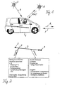
- Fig. 1 shows a schematic representation of an automobile 1, the for performing inventive, explained in more detail below Process variants is set up, and the implemented Communication structure.
- the automobile 1 includes various Data processing components, in particular an on-board computer with associated periphery, that of conventional construction are, unless otherwise stated below, and therefore in Fig. 1 is only symbolically represented by a notebook 2 are.
- the on-board data processing electronics 2 include in particular next to the actual on-board or vehicle computer Route guidance system with associated location aids and an on-board sensor system for recording measured values via attributes, i.e. route-related Further information.
- the locating means are given in usual (D-) GPS signals from corresponding satellites 3 via an associated unidirectional satellite communication channel 4.
- a bidirectional communication channel 5 e.g. can be a satellite or GSM communication channel
- the on-board sensor system mentioned detects instantaneous values given terrain / traffic attributes, such as with an arrow E symbolized, which is then used to update a data processing Traffic network map, in the present example a digital road map can be used.
- the digital road map can be in the on-board electronics 2 of the Vehicle 1 itself or in a related to it Central or another vehicle can be implemented.
- the vehicle 1 forms a test vehicle with which Continuous measurement data about the current vehicle position while driving and related terrain and traffic attributes won and to update the digital accordingly Road map can be used.
- the ongoing in this way The on-board electronics will then keep the digital road map up to date 2 used to provide predictive information about the terrain and traffic characteristics of the front of the vehicle 1 lying section of the route as vehicle guidance-relevant information provide as symbolized by an arrow A.
- the procedure according to the invention is characterized by suitable use of hardware components common in modern vehicles can be realized, practically any such vehicle as a test vehicle serve. Therefore, the collection and use of the road network information and the additional attributes are autonomous to the vehicle, i.e. only in your own vehicle with no exchange of information other vehicles or a control center. A large number of test vehicles improves the degree of update of the digital Map. On the other hand, those obtained in different vehicles Information also through mutual exchange or Transmission to the head office can be merged across the board.
- conventional telematics techniques using the mentioned Communication channels can display the current data of the Route network card for all system participants, i.e. everyone involved Vehicles and, if necessary, associated central offices be put. For example, the collection of currently in attribute data recorded in various vehicles be provided in a central, which depends on it centrally a data processing-supported route network map held by her updated and the connected vehicles the current Provides card data.
- Attributes include, in particular, geographical ones Peculiarities of the road network provided, namely with regard to the geographical coordinates including altitude, i.e. the Gradient. It is not only the occurrence of incline or Slopes and curves per se in the digital Card registered, but also its strength, e.g. in the form of the recorded value for the slope or for the curve radius. So can in particular be a quasi continuous attribution of the Road network with the road gradient and curve values be provided.
- attributes stored in a precise location are taken into account be like speed attributes over a typical medium vehicle speed or a speed limit with specification of a maximum or minimum speed, typical road sign attributes, such as when entering a town, a freeway start, a motor road, a priority road etc., typical prohibition sign attributes, such as above a ban on overtaking, a prohibited passage or a ban on certain vehicles such as Motorcycles or trucks, so-called POI (point of interest) attributes, such as via breakdown assistance, First aid, a police station, a hotel, a rest area or a gas station, restriction attributes, e.g.
- a maximum Headroom a maximum vehicle weight or one time limit
- direction of travel attributes via Restrictions on the permitted directions of travel and in particular also traffic situation attributes over the expected average Traffic situation or traffic condition, such as free traffic, brisk Traffic, heavy traffic, rush hour, stop & go traffic etc.
- these attributes can also be time-based as required can be recorded and stored in the digital map, i.e. that for the same street location at different times different values for the respective attribute are kept on the map become. This is especially true for the traffic attributes important, whose values fluctuate periodically may be subject to.
- the attributes are preferred also directional, i.e. are different for the same street location Values of the same attribute for the different ones Driving directions possible.
- Each at a specific point P recorded attribute values can then together with the location specification for this waypoint P, i.e. with him in the trail network identifying data in the form of its geographic coordinates possibly supplemented by a unique identifier in the digital Card can be saved.
- the location information belonging to the attributes is given in an analogous manner learned from the map, but not fixed in place, to avoid an acquired attribute due to a position measurement error assigned an incorrect attribute position becomes. Again, this is provided with a suitable, conventional one statistical procedures from all to a given Attribute known positions within a specified tolerance to determine a valid, relativized position value and assign the attribute to the relevant position.
- a suitable, conventional one statistical procedures from all to a given Attribute known positions within a specified tolerance to determine a valid, relativized position value and assign the attribute to the relevant position.
- the map update preferably also includes the measure that at least some of the attributes in the map are not held indefinitely assigned to a specific position become.
- the map thus updated takes into account For example, hiking construction sites where one at a certain point in time recognized and learned as an attribute Route restriction exists at a later date canceled or shifted on the route.
- location and attribute data regardless of the statistical method of learning only be deployed to an application if it has one have a predefined level of trust.
- the level of trust gives the reliability of the attribute recognition, i.e.
- the entire basic graph ie the traffic network that can be driven on
- the desired attributes can be assigned to it for the first time to the meter, using the method according to the invention.
- the attributes and the base graph can be corrected by saved deviations. In this way, the learning map can learn new intersections, bypasses etc.
- the card which is always kept up to date in this way, can be made available to all vehicles involved in the system, either directly or via a control center, or can be used locally 2 illustrates, after entering the vehicle position determined by the locating means, for example in the form of geographic coordinates, the stored values of corresponding attributes can be read out, and preferably not only the attributes stored for this location itself, but also those within a predeterminable look-ahead area in Attributes contained in front of the vehicle The latter measure makes it possible to provide information for predictive vehicle guidance.
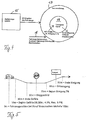
- FIG. 3 The typical sequence of an attribution process is in FIG. 3 illustrated.
- the right drawing shows a section of the navigable road network, the left field contains in one Function block exemplary data of a specific attribution.
- An example is the driving on a dashed line Circuit 10 accepted.
- the vehicle position is continuously updated using a GPS reading and a subsequent one Map matching determined.
- Map matching determined.
- the GPS measured values along the circuit 10, which are subject to measurement errors may differ slightly from the real vehicle position and shown in Fig. 3 by way of example with a dotted line 11 are on the network of routes available in the digital map pictured.
- the location coordinate measured values together with the vehicle mileage on the digital road map updating System part passed, from which a fan circle 12 forms, which come into question for the measured vehicle position Contains road edges.
- the card-learning system part is determined then with map matching or a suitable conventional one Coupling algorithm that road edge within the catch circle 12, the actual route section traveled should match and thus close irrelevant road edges as far as possible. Then based on several successive Position determination the direction of travel on the determined Street edge determined.
- the membership is an example in FIG. 3 the current vehicle position to an edge with Identity number 4711 and a first direction of travel (direction 1) accepted. If it is a time-saving attribute the current time is also taken into account.
- the current attribute value for the card current vehicle position recorded in parallel to the vehicle position determination for each in the Attribute to be saved.
- An example is in 3 the determination of a slope value of 6.3% for the attribute "Gradient course" reproduced. From the recorded attribute value then becomes a corresponding one or one of these and previous attribute values recorded here statistically derived, new attribute value determined and in the digital map assigned to the determined position.
- the energy consumption optimizer Forward-looking vehicle guidance information generated with which the driver or an autonomous vehicle guidance system the driving style in time at the upcoming Route can adjust so that energy consumption is kept as low as possible for the journey. In particular can therefore take turns, as well as up and down gradients, but also other driving impairments in good time consumption-reducing vehicle control measures are initiated.
- the consumption assistant system part 13 contains, in addition to other, conventional components, such as those readily apparent to a person skilled in the art from the following description of the mode of operation of the consumption assistant 13, in particular also, as mentioned, an adaptable, updatable card 14 of the type described above Position measuring device or a navigation system 15, the consumption assistant 13 receives the required vehicle position information. Furthermore, the consumption assistant 13 receives current attribute values 16 for the attributes of the card 16 in the form of values recorded by the relevant sensor system, which are each supplied via data bus lines. This includes the possibility of optical recognition by means of an image recording and image evaluation system, also referred to as "computer vision". With the recorded data, the core functionality learning card ", which may update the card 14 from the consumption assistant 13 or another system part.
- the learning card 14 has a look-ahead functionality, which means that for a given apron area, in present example approx. 100m, in the direction of travel in front of the vehicle those within this area for the street edge being traveled stored attribute values can be provided, in particular also the route.
- apron area in present example approx. 100m
- the thereby available Information about the characteristics of the terrain ahead the consumption assistant 13 then uses to generate predictive, energy-saving vehicle control measures, such as braking, acceleration and / or steering measures.
- Fig. 5 shows a concrete example of an application of such Preview process by the consumption assistant 13.
- the consumption assistant receives from the learnable road map 14 13 exemplary the information that measured a descent from the current vehicle position after 10m begins, which ends after another 20m and an average Gradient of 5%, a minimum gradient of 4.3% and a maximum Slope of 5.9% has a stop sign 50m in front of the vehicle stands and a slope begins 75m in front of the vehicle, which is 17m long and has a gradient of 7%, where 85m in front of the vehicle there is an entrance sign, which is known also represents a speed limit.
- the consumption assistant 13 is in the Able to generate predictive vehicle control measures with the help of this route section with as little as possible Energy consumption can be covered.
- the consumption assistant 13 shortly before reaching on the downhill slope or before reaching the stop sign for the accelerator pedal return and before reaching the slope in time, smooth acceleration taking into account that by entering the town prompt the following speed limit or this initiate.
- the consumption assistant 13 can Preparing a curve based on its radius of curvature prompt for an appropriate accelerator pedal retraction or braking or initiate this.
- the vehicle control information provided by the consumption assistant 13 can serve as driving instructions for the driver and in this case they will be displayed appropriately.
- vehicle management measures generated by the consumption assistant 13 for autonomous management with optimized consumption of the vehicle. It is understood that the expansion of the look-ahead area any desired Can have value or can be selected depending on the situation can be e.g. speed-dependent for higher driving speeds larger than for lower speeds.
- the consumption assistant for the determination of energy consumption-optimal travel routes to one Be designed destination reads from the digital Map 14 shows the values of the consumption-related attributes for the relevant route network area between the vehicle start location and the destination and determined based on this attribute data a route using a conventional route search method with the lowest possible energy consumption to the destination.
- Updatable road map 14 also a non-learning road map can be used for the consumption assistant 13, which the required attribute data relevant to energy consumption as in advance e.g. stored on the basis of test drives, not contains continuously updated information.
- vehicle type-specific attribute data is also stored stored in it and to generate more specific vehicle type Vehicle guidance information used to, for example the use of traffic routes by special vehicles, such as commercial vehicles, especially dangerous goods, on certain Prevent times of day or on certain days of the week.
- the upgradeable road network map serve to implement an intelligent cruise control, which is always the maximum permitted speed on the traffic Set route based on vehicle type and, if necessary, time-dependent.
Abstract
Description
Die Erfindung bezieht sich auf ein Verfahren zur Aktualisierung einer datenverarbeitungsgestützten Verkehrswegenetzkarte nach dem Oberbegriff des Anspruchs 1 sowie auf ein Verfahren zur Erzeugung von Fahrzeugführungsinformationen nach dem Oberbegriff des Anspruchs 3, bei dem eine solche Verkehrswegenetzkarte einsetzbar ist.The invention relates to a method for updating a data processing-supported traffic network map the preamble of claim 1 and a method for production of vehicle management information according to the generic term of claim 3, in which such a traffic network map can be used is.
Unter einer datenverarbeitungsgestützten Verkehrswegenetzkarte wird dabei eine mittels Datenverarbeitung selbsttätig verwaltete Karte eines von Fahrzeugen befahrbaren Verkehrswegenetzes verstanden, wie z.B. sogenannte digitale Karten. Die Karten beinhalten Strecken- oder Ortsdaten, worunter die Daten verstanden werden, die den Streckenverlauf der befahrbaren Streckenabschnitte des Wegenetzes definieren, und zugeordnete Attributdaten, d.h. Daten über Zusatzeigenschaften der verschiedenen Streckenabschnitte. Diese Attribute umfassen herkömmlicherweise z.B. Informationen, die entlang der tatsächlichen Verkehrswege durch Verkehrsschilder angezeigt werden, wie Streckentyp, Richtungsbefahrbarkeit, Geschwindigkeitsbeschränkungen etc., aber auch Informationen über die zu erwartende Verkehrslage, z.B. sogenannte Ganglinieninformationen. In allen Fällen können die Attributdaten mit Zeitbezug in der Karte abgelegt sein, d.h. der Wert eines Attributs kann für verschiedene Jahreszeiten oder Tage oder auch tageszeitabhängig verschieden sein. Anhand der Daten aus einer solchen Verkehrswegenetzkarte lassen sich dann Fahrzeugführungsinformationen erzeugen, z.B. in Form von Routenwahlinformationen über die Wahl einer günstigsten Route zu einem Zielort und/oder in Form von Fahrzeugsteuerungsinformationen zur Unterstützung des Fahrers bei der Fahrzeugführung oder zur autonomen Fahrzeugführung.Under a data processing-supported traffic network map is automatically managed by means of data processing Understood a map of a traffic route network accessible by vehicles, such as. so-called digital maps. The cards include Route or location data, what the data meant be the route of the passable sections of the route network, and assigned attribute data, i.e. Data on additional properties of the various Route sections. These attributes traditionally include e.g. Information that goes along the actual traffic routes are indicated by traffic signs, such as route type, directional accessibility, Speed limits etc. but also information about the expected traffic situation, e.g. so-called Chart information. In all cases, the attribute data be stored in the card with a time reference, i.e. the An attribute's value can be for different seasons or Days or also depending on the time of day. Based on Data from such a traffic network map can then be Generate vehicle guidance information, e.g. in the form of route selection information about choosing a cheapest route to one Destination and / or in the form of vehicle control information Assistance to the driver in vehicle control or for autonomous Vehicle guidance.
Durch die Verwendung eines oder mehrerer Probefahrzeuge, d.h. Fahrzeugen, die zur Aufnahme der erforderlichen aktuellen Orts- und Attributdaten ausgerüstet sind, läßt sich eine laufende oder jedenfalls in verhältnismäßig kurzen Zeitabständen, z.B. stündlich oder täglich, erfolgende Aktualisierung der Verkehrswegenetzkarte realisieren. Als Probefahrzeuge können insbesondere die ohnehin vorhandenen und benutzten Fahrzeuge eingesetzt werden, so daß im allgemeinen keine speziellen Fahrten nur für den Zweck der Kartenaktualisierung erforderlich sind.By using one or more test vehicles, i.e. Vehicles required to record the current location and Attribute data, a running or at least in relatively short time intervals, e.g. hourly or daily, updated traffic network map realize. In particular, as test vehicles the existing and used vehicles are used, so that in general no special trips only for the Purpose of map updates are required.
Ein gattungsgemäßes Verfahren zur Aktualisierung einer digitalen Straßenkarte ist in der Patentschrift DE 195 25 291 C1 beschrieben. Beim dortigen Verfahren bestehen die Attribute praktisch ausschließlich aus Informationen über die Zulässigkeit des Befahrens eines jeweiligen Straßenabschnitts in mindestens einer Richtung. Die hierzu in der digitalen Karte abgelegten Attributwerte werden anhand von aktuellen Attributwerten aktualisiert, die vom jeweiligen Probefahrzeug unter Berücksichtigung von dessen fortlaufend bestimmter aktueller geographischer Position aufgenommen werden. Dies geschieht z.B. durch Erkennung entsprechender Verkehrsschilder über eine Videokamera oder implizit dadurch, daß ein die Daten verarbeitender Verkehrsrechner das Befahren eines jeweiligen Straßenabschnitts durch ein Probefahrzeug in der betreffenden Fahrtrichtung erkennt. Um fehlerhafte Zielführungen und Verkehrslenkungen auszuschließen, können alle Straßenabschnitte, für die innerhalb eines vorgegebenen Zeitraums keine aktuellen Attributdaten über die Zulässigkeit des Befahrens aufgenommen worden sind, auf den Attributwert "Befahrung unzulässig" gesetzt werden. Während die Position des Probefahrzeugs gegebenenfalls ortsgenau ermittelt wird, z.B. durch eine GPS-Bestimmung mit zusätzlicher DGPS-Korrektur und optional einem anschließenden sogenannten Map-Matching, ist eine entsprechend ortsgenaue Zuordnung der Attribute dort nicht angesprochen und für die betrachteten Attribute auch nicht erforderlich.A generic method for updating a digital Road map is described in the patent DE 195 25 291 C1. In the process there, the attributes exist practically exclusively from information about the permissibility of driving of a respective street section in at least one Direction. The attribute values stored for this in the digital map are updated based on current attribute values, that of the respective test vehicle taking into account its continuously determined current geographic position be included. This happens e.g. by recognizing appropriate Traffic signs via a video camera or implicitly that a traffic computer processing the data the traffic of a respective road section by a test vehicle recognizes in the relevant direction of travel. To be faulty Everyone can rule out route guidance and traffic control Road sections for which within a given period of time no current attribute data on the admissibility of the Driving have been added to the attribute value "driving not allowed ". While the position of the test vehicle is determined, if necessary, precisely, e.g. by GPS determination with additional DGPS correction and optional a subsequent so-called map matching is one location-specific assignment of attributes not addressed there and also not required for the considered attributes.
Bei einem in der Offenlegungsschrift DE 196 50 844 A1 beschriebenen Verfahren zur Ermittlung von Fahrtroutendaten ist eine Attributierung, d.h. Attributzuordnung, für eine digitale Wegenetzkarte durch statische und dynamische Parameter vorgesehen. Die statischen Parameter umfassen insbesondere bauliche Merkmale der Verkehrswege, wie Fahrspuranzahl, Vorhandensein einer Steigungs- oder Gefällstrecke und Straßentyp. Die dynamischen Parameter umfassen Informationen über die zu erwartende Verkehrslage bzw. den zu erwartenden Verkehrsfluß, z.B. die Anzahl und die mittlere Geschwindigkeit der Fahrzeuge in einem gegebenen Streckenabschnitt und Zeitraum. Während die dynamischen Parameter anhand fahrzeugseitig aufgenommener Meßdaten aktualisiert werden, werden die Werte der statischen Parameter nicht in dieser Weise angepaßt.In one described in the published patent application DE 196 50 844 A1 The procedure for determining route data is attribution, i.e. Attribute mapping for a digital route network map provided by static and dynamic parameters. The static parameters particularly include structural features the traffic routes, such as number of lanes, presence of a slope or Slope and road type. The dynamic parameters include information about the expected traffic situation or the expected traffic flow, e.g. the number and the average speed of the vehicles in a given section of the route and period. While based on the dynamic parameters measurement data recorded on the vehicle side are updated, the values of the static parameters are not this way customized.
Aus der Offenlegungsschrift DE 37 00 552 A1 ist es bekannt, für eine digitale Straßenkarte sicherheitsrelevante Informationen als Attribute abzuspeichern, die unter anderem das Vorhandensein von Gefällstrecken, Steigungen und Kurven beinhalten und vorab bei der Erstellung der Karte durch spezielle Versuchsfahrzeuge empirisch ermittelt werden. Beim späteren Befahren eines jeweiligen Streckenabschnitts durch ein mit der Karte ausgerüstetes Fahrzeug werden dann die abgespeicherten sicherheitsrelevanten Informationen für den jeweiligen Streckenabschnitt dem Fahrer zur Anzeige gebracht.From the published patent application DE 37 00 552 A1 it is known for a digital road map of safety-related information to save as attributes that include the existence of inclines, inclines and curves and include in advance when creating the map using special test vehicles be determined empirically. When driving on a respective one later Section of the route through a map-equipped one The stored safety-relevant vehicle will then become Information for the respective route section to the driver brought to the display.
Aus der Patentschrift DE 43 44 369 C2 ist ein Verfahren zur verbrauchsorientierten Fahrleistungsbegrenzung eines Fahrzeugantriebs während einer Fahrt zu einem gewünschten Zielort bekannt, bei dem ein Verkehrsrechner während der Fahrt wiederholt auf der Basis eines gemessenen aktuellen Energievorrats einen zulässigen Soll-Streckenverbrauch zur Bewältigung der Strecke bis zum Zielort ermittelt und daraus einen Vorgabewert zur Fahrleistungsbegrenzung derart ableitet, daß die Fahrleistung umso stärker begrenzt wird je kleiner der ermittelte Soll-Streckenverbrauch ist. Zu diesem Zweck werden Kennlinien über den Energieverbrauch benutzt, die streckenspezifisch unterschiedlich vorgegeben werden, unter anderem in Abhängigkeit davon, ob die betreffende Wegstrecke eine hügelige, eine bergige, bergauf führende oder eine leicht bergige, bergab führende Topographie aufweist, wozu entsprechende Streckeninformationen vorab aufgenommen werden, z.B. während einer entsprechenden Probefahrt.From the patent DE 43 44 369 C2 is a method for consumption-oriented Mileage limitation of a vehicle drive known while driving to a desired destination, where a traffic computer repeats on the road Based on a measured current energy supply an allowable Target route consumption to cover the route to the destination determined and from this a default value for mileage limitation derives in such a way that the mileage is limited even more the smaller the determined target distance consumption is. For this purpose, characteristic curves about energy consumption used, which are specified differently depending on the route, inter alia depending on whether the A hilly, mountainous, or uphill path has a slightly mountainous, downhill topography, what for corresponding route information is recorded in advance, e.g. during a corresponding test drive.
In der Patentschrift DE 195 06 364 C2 ist ein Fahrzeugsteuersystem beschrieben, mit dem eine autonome Führung eines Straßenfahrzeugs unter Verwendung einer digitalen Straßenkarte möglich ist, in welcher fiktive Straßenknoten abgelegt sind, zu denen bevorzugt Verzweigungen, Kreuzungen und Kurven der Straße gehören. Das Fahrzeugsteuersystem leitet anhand dieser Knoteninformationen der digitalen Karte den Krümmungsverlauf des vor dem Fahrzeug liegenden Straßenabschnitts ab und steuert einen entsprechenden Lenkwinkel und eine geeignete Fahrgeschwindigkeit ein.In the patent DE 195 06 364 C2 is a vehicle control system with which an autonomous guidance of a road vehicle possible using a digital road map is in which fictional road nodes are stored, to which preferred branches, intersections and curves of the road belong. The vehicle control system guides based on this node information the digital map the curvature of the before Vehicle lying section of road and controls a corresponding Steering angle and a suitable driving speed on.
Der Erfindung liegt als technisches Problem die Bereitstellung eines Verfahrens zur Aktualisierung einer Verkehrswegenetzkarte und eines kartengestützten Verfahrens zur Erzeugung von Fahrzeugführungsinformationen der eingangs genannten Art zugrunde, durch die eine aktuell bleibende Verkehrswegenetzkarte bereitgestellt werden kann, die sich insbesondere auch zur Vorausschätzung des Fahrtenergieverbrauchs und/oder als Basis zur Ermittlung vorausschauender Fahrzeugsteuerungsmaßnahmen eignet, und durch die Fahrzeugführungsinformationen erzeugt werden können, die insbesondere den Fahrer unterstützende oder eine autonome Fahrzeugführung ermöglichende, energieverbrauchsoptimierende Fahrzeugsteuerungsinformationen oder energieverbrauchsabhängige Routenwahlinformationen enthalten können.The invention is a technical problem of providing a method for updating a traffic network map and a card-based method for generating vehicle guidance information of the type mentioned at the beginning, provided by a current traffic network map that can be used in particular for forecasting of travel energy consumption and / or as a basis for determination predictive vehicle control measures, and through which vehicle guidance information can be generated which particularly supports the driver or is autonomous Enabling vehicle guidance, optimizing energy consumption Vehicle control information or energy consumption dependent May contain route selection information.
Die Erfindung löst dieses Problem durch die Bereitstellung eines Verfahrens zur Aktualisierung einer Verkehrswegenetzkarte mit den Merkmalen des Anspruchs 1 und ein Verfahren zur Erzeugung von Fahrzeugführungsinformationen mit den Merkmalen des Anspruchs 3.The invention solves this problem by providing a Procedure for updating a traffic network map with the features of claim 1 and a method for production vehicle guidance information with the features of the claim 3rd
Beim Kartenaktualisierungsverfahren nach Anspruch 1 ist charakteristischerweise vorgesehen, daß ortsgenaue Topographiedaten, auch Topologiedaten bezeichnet, über den Steigungs- und/oder Kurvenverlauf wenigstens eines Teils der Streckenabschnitte des abgelegten Verkehrswegenetzes als Attributdaten verwendet werden, wobei zusätzlich je nach Anwendungsfall weitere herkömmliche Attributdaten berücksichtigt werden können. Die ortsgenauen Topographie- und eventuellen weiteren Attributdaten werden in der Karte abgelegt und anhand von diesbezüglichen aktuellen Meßdaten eines jeweiligen Probefahrzeuges aktualisiert. Mit "ortsgenau" ist gemeint, daß die Topographiedaten nicht lediglich topologiebezogen über das bloße Vorhandensein einer Steigungsstrecke, worunter vorliegend auch eine Gefällstrecke verstanden wird, bzw. einer Kurve irgendwo auf einem zwischen zwei Streckenknoten verlaufenden Streckenabschnitt, auch Streckenkante genannt, informieren, sondern weitergehend über die genaue geographische Lage derselben auf der Streckenkante und deren Stärke, z.B. in Form des Steigungswertes bzw. Kurvenkrümmungswertes. Auch die gegebenenfalls weiter vorgesehenen, herkömmlichen Attributdaten, wie typische Verkehrsschildinformationen, werden bevorzugt in dieser Weise ortsgenau in der Wegenetzkarte gespeichert und aktualisiert. Es versteht sich, daß die Attribute zusätzlich, wie üblich, zeitbezogen abgelegt sein können. Außerdem sind sie normalerweise richtungsspezifisch, d.h. sie können an derselben Wegenetzposition für verschiedene Fahrtrichtungen unterschiedliche Werte haben.The map update method according to claim 1 is characteristic provided that location-specific topography data, also referred to as topology data on the slope and / or Curve course of at least part of the route sections of the stored traffic route network can be used as attribute data, with additional conventional ones depending on the application Attribute data can be taken into account. The exact location Topography and any other attribute data are in stored on the card and based on current measurement data relating to this of a respective test vehicle updated. With "exact location" means that the topography data is not just topology-related about the mere existence of a slope, which in the present case also means a downhill gradient or a curve somewhere on one between two route nodes running route section, also called route edge, inform, but more about the exact geographical Position of the same on the edge of the track and its thickness, e.g. in the form of the slope value or curve curvature value. The conventional attribute data, which may also be provided, like typical traffic sign information preferably stored precisely in this way in the route network map and updated. It goes without saying that the attributes additionally, as usual, can be filed time-related. Moreover they are usually directional, i.e. you can join same route network position for different directions different Have values.
Mit dieser Vorgehensweise ist es möglich, die Verkehrswegenetzkarte auf eine Änderung der Streckenführung hin, z.B. wegen einer Baustelle oder eines neuen Streckenabschnitts, sehr rasch und selbsttätig auf den entsprechend aktualisierten Stand zu bringen. Eine solchermaßen stets aktuell gehaltene Verkehrswegenetzkarte kann durch die in ihr enthaltenen ortsgenauen Attributdaten als Basis zur Erzeugung von Fahrzeugführungsinformationen dienen, die solche Informationen benötigen, z.B. für energieverbrauchsoptimierende Fahrzeugführungsmaßnahmen. Es versteht sich, daß unter Aktualisierung vorliegend auch die erstmalige Erstellung einer Verkehrswegenetzkarte bzw. die erstmalige Berücksichtigung eines neu hinzukommenden Streckenabschnitts zu verstehen ist.With this procedure it is possible to use the traffic network map a change in the route, e.g. because of a Construction site or a new section, very quickly and automatically to the correspondingly updated status bring. A traffic network map that is always kept up to date can by the location-specific attribute data contained in it as the basis for generating vehicle guidance information serve who need such information, e.g. for energy consumption optimizers Vehicle control measures. It understands yourself, that in the present case also the first time Creation of a traffic network map or the first-time consideration of a newly added route section understand is.
In Weiterbildung des Kartenaktualisierungsverfahrens ist nach Anspruch 2 vorgesehen, als Daten eines jeweiligen Attributs neben dem aktuellen Wert und der aktuellen Position auch zuvor für dieses Attribut aufgenommene Werte oder Positionen daraus abgeleitete Größen, wie einen Mittelwert, einen Minimalwert und einen Maximalwert oder andere statistische Kenngrößen hiervon, sowie wie die Anzahl der berücksichtigten, früher aufgenommenen Werte abzuspeichern. Dies kann für eine statistische Attributaktualisierung genutzt werden, bei welcher der in der Karte enthaltene Attributwert und Ort nicht direkt durch einen neu aufgenommenen Attributwert, sondern durch einen relativierten Attributwert und Ort ersetzt wird, in den der neue Attributwert zusammen mit den zusätzlich in der Karte enthaltenen statistischen Daten eingeht. Damit lassen sich grobe Fehlaktualisierungen aufgrund vorheriger Fehlmessungen verhindern.In further training of the map update procedure is after Claim 2 provided as data of a respective attribute in addition the current value and the current position before for values or positions derived from this attribute Quantities such as an average, a minimum and one Maximum value or other statistical parameters thereof, as well like the number of previously taken into account Save values. This can be for a statistical attribute update are used, in which the one contained in the card Attribute value and location not directly by a newly added one Attribute value, but by a relativized attribute value and place where the new attribute value is put together with the additional statistical data contained in the map Data received. This can be used to avoid gross incorrect updates Prevent previous incorrect measurements.
Das Verfahren zur Fahrzeugführungsinformationserzeugung nach Anspruch 3 macht charakteristischerweise von Attributdaten einer datenverarbeitungsgestützten Verkehrswegenetzkarte Gebrauch, die ortsgenaue Daten der Netzgeometrie, wie oben erläutert, beinhaltet und je nach Anwendungsfall zusätzliche herkömmliche Attributdaten enthalten kann. Auf der Basis einer solchen Karte werden jeweils die zu einem vorgebbaren Vorausschau-Wegenetzbereich, d.h. einem sich von der momentanen Fahrzeugposition bis zu einer vorgebbaren Vorausschaugrenze in der beabsichtigten Fahrtrichtung erstreckenden Bereich des Verkehrswegenetzes, gehörigen Informationen ausgelesen und zur Erzeugung davon abhängiger Fahrzeugführungsinformationen herangezogen. Durch die Berücksichtigung der Attributdaten mit genauem Ortsbezug können Vorausinformationen hoher Genauigkeit und Aktualität für die Fahrzeugführung bereitgestellt werden, z.B. zum vorausschauenden Beschleunigen kurz vor Erreichen einer Bergaufstrecke, zum vorausschauenden Verzögern kurz vor Erreichen einer Bergabstrecke oder einer Kurve, zur Minderung des Energieverbrauchs zum Auffinden einer hinsichtlich Energieverbrauch günstigen Fahrtroute zu einem Zielort etc.The method for vehicle guidance information generation according to claim 3 characteristically makes one of attribute data computerized traffic network map use that includes location-specific data of the network geometry, as explained above and additional conventional attribute data depending on the application may contain. On the basis of such a card each for a predeterminable route network area, i.e. one from the current vehicle position to a definable one Look-ahead limit in the intended direction of travel extending area of the traffic network, related information read out and for generating dependent vehicle management information used. By considering The attribute data with exact location reference can provide advance information high accuracy and timeliness for vehicle management e.g. for anticipatory acceleration shortly before reaching an uphill route, to the foresighted Decelerating shortly before reaching a downhill section or a curve, to reduce energy consumption to find one regarding Energy consumption cheap route to a destination Etc.
Bei dem nach Anspruch 5 weitergebildeten Verfahren beinhalten die erzeugten Fahrzeugführungsinformationen Parameter über den für eine Fahrt zu einem vorgebbaren Zielort zu erwartenden Energieverbrauch auf den betreffenden Wegenetzabschnitten, wozu insbesondere die abgelegten Informationen über Ausdehnung und Stärke von Steigungs- und Gefällstrecken sowie weiterer verbrauchsrelevanter Attribute benutzt werden. Mit dieser Vorgehensweise kann vorausgeschätzt werden, ob ein gewünschter Zielort mit dem gegenwärtigen Energievorrat noch erreicht werden kann oder eine Energiebetankung notwendig ist. Es versteht sich, daß der Zielort nicht fest vorgegeben werden muß, sondern variabel gehalten werden kann.In the method further developed according to claim 5 the vehicle guidance information generated via the parameters energy consumption to be expected for a journey to a predeterminable destination on the relevant network sections, in particular for what the stored information about extent and strength of inclines and descents as well as other consumption-related ones Attributes are used. With this approach can be predicted whether a desired destination with the current energy supply can still be reached or a Energy refueling is necessary. It is understood that the destination does not have to be fixed, but kept variable can be.
In Weiterbildung der Erfindung nach Anspruch 6 wird als Vorausschaubereich ein Vorfeldbereich der momentanen Fahrzeugposition herangezogen, d.h. ein direkt vor dem Fahrzeug liegender Bereich mit einer Länge von typischerweise einigen zehn bis wenigen hundert Metern, und für diesen werden die zugehörigen streckenbezogenen Attributdaten ausgelesen, um z.B. energieverbrauchsoptimierende Informationen zur Steuerung des Fahrzeugs, d.h. zur Beeinflussung von dessen Längs- und Querdynamik, zu erzeugen. Diese können in reinen Anzeigeinformationen für den Fahrer oder in Informationen für ein autonomes Fahrzeugführungssystem bestehen, das dann selbsttätig die entsprechenden Fahrzeugsteuerungseingriffe vornimmt.In a further development of the invention according to claim 6 is used as a look-ahead area an apron area of the current vehicle position used, i.e. an area directly in front of the vehicle with a length of typically a few tens to a few hundred Meters, and for this the associated route-related Read attribute data in order to e.g. optimizing energy consumption Information to control the vehicle, i.e. for influencing of its longitudinal and transverse dynamics. This can be in pure display information for the driver or in There is information for an autonomous vehicle guidance system, then the corresponding vehicle control interventions automatically makes.
Vorteilhafte Ausführungsformen der Erfindung sind in den Zeichnungen veranschaulicht und werden nachfolgend beschrieben. Hierbei zeigen:
- Fig. 1
- eine schematische Veranschaulichung einer Kommunikationsstruktur eines Automobils mit der Fähigkeit zur Aktualisierung einer digitalen, attributbehafteten Straßenkarte und zur Erzeugung von Fahrzeugführungsinformationen,
- Fig. 2
- eine schematische Funktionsblockdarstellung über das Einspeichern und Auslesen von Attributwerten der digitalen Straßenkarte gemäß Fig. 1,
- Fig. 3
- eine schematische Darstellung eines Vorgangs zur Einspeicherung eines aufgenommenen Attributwertes für die digitale Straßenkarte gemäß Fig. 1,
- Fig. 4
- eine schematische Funktionsblockdarstellung einer Verbrauchsassistent-Einheit des Fahrzeugs von Fig. 1 und
- Fig. 5
- eine schematische Darstellung eines vor dem Fahrzeug von Fig. 1 liegenden Streckenabschnitts zur Veranschaulichung der Arbeitsweise der Vorausschaufunktion der Verbrauchsassistent-Einheit von Fig. 4 auf Basis der gelernten Attribute.
- Fig. 1
- 1 shows a schematic illustration of a communication structure of an automobile with the ability to update a digital, attribute-laden road map and to generate vehicle guidance information,
- Fig. 2
- 1 shows a schematic functional block representation of the storing and reading out of attribute values of the digital road map according to FIG. 1,
- Fig. 3
- 1 shows a schematic representation of a process for storing a recorded attribute value for the digital road map according to FIG. 1,
- Fig. 4
- is a schematic functional block diagram of a consumption assistant unit of the vehicle of FIGS. 1 and
- Fig. 5
- 1 shows a schematic representation of a route section lying in front of the vehicle of FIG. 1 to illustrate the mode of operation of the preview function of the consumption assistant unit of FIG. 4 on the basis of the learned attributes.
Fig. 1 zeigt in schematischer Darstellung ein Automobil 1, das zur Durchführung erfindungsgemäßer, nachfolgend näher erläuterter Verfahrensvarianten eingerichtet ist, und die dazu implementierte Kommunikationsstruktur. Dabei umfaßt das Automobil 1 diverse Datenverarbeitungskomponenten, insbesondere einen Bordrechner mit zugehöriger Peripherie, die von herkömmlichem Aufbau sind, soweit nachstehend nichts anderes gesagt, und daher in Fig. 1 lediglich symbolisch durch ein Notebook 2 wiedergegeben sind. Die bordeigene Datenverarbeitungselektronik 2 umfaßt insbesondere neben dem eigentlichen Bord- oder Fahrzeugrechner ein Zielführungssystem mit zugehörigen Ortungsmitteln und eine Bordsensorik zur Aufnahme von Meßwerten über Attribute, d.h. streckenbezogene Zusatzinformationen. Fig. 1 shows a schematic representation of an automobile 1, the for performing inventive, explained in more detail below Process variants is set up, and the implemented Communication structure. The automobile 1 includes various Data processing components, in particular an on-board computer with associated periphery, that of conventional construction are, unless otherwise stated below, and therefore in Fig. 1 is only symbolically represented by a notebook 2 are. The on-board data processing electronics 2 include in particular next to the actual on-board or vehicle computer Route guidance system with associated location aids and an on-board sensor system for recording measured values via attributes, i.e. route-related Further information.
Die Ortungsmittel erhalten zur Fahrzeugpositionsbestimmung in üblicher Weise (D-)GPS-Signale von entsprechenden Satelliten 3 über einen zugehörigen unidirektionalen Satellitenkommunikationskanal 4. Über einen bidirektionalen Kommunikationskanal 5, der z.B. ein Satelliten- oder GSM-Kommunikationskanal sein kann, steht das Fahrzeug 1 direkt oder über Satellit 6 mit anderen Straßenfahrzeugen und/oder einer Verkehrszentrale in Datenaustauschverbindung. Die erwähnte Bordsensorik erfaßt Momentanwerte vorgegebener Gelände-/Verkehrsattribute, wie mit einem Pfeil E symbolisiert, die dann zur Aktualisierung einer datenverarbeitungsgestützten Verkehrswegenetzkarte, im vorliegenden Beispiel einer digitalen Straßenkarte, herangezogen werden können. Die digitale Straßenkarte kann dabei in der Bordelektronik 2 des Fahrzeugs 1 selbst oder in einer mit ihr in Verbindung stehenden Zentrale oder einem anderen Fahrzeug implementiert sein. Mit anderen Worten bildet das Fahrzeug 1 ein Probefahrzeug, mit dem während der Fahrt fortwährend Meßdaten über die aktuelle Fahrzeugposition und über zugehörige Gelände- und Verkehrsattribute gewonnen und zur entsprechenden Aktualisierung der digitalen Straßenkarte herangezogen werden. Die auf diese Weise laufend aktuell gehaltene digitale Straßenkarte wird dann von der Bordelektronik 2 dazu genutzt, vorausschauende Informationen über die Gelände- und Verkehrscharakteristika des vor dem Fahrzeug 1 liegenden Streckenabschnitts als fahrzeugführungsrelevante Informationen bereitzustellen, wie mit einem Pfeil A symbolisiert.The locating means are given in usual (D-) GPS signals from corresponding satellites 3 via an associated unidirectional satellite communication channel 4. Via a bidirectional communication channel 5, e.g. can be a satellite or GSM communication channel, is the vehicle 1 directly or via satellite 6 with others Road vehicles and / or a traffic center in data exchange connection. The on-board sensor system mentioned detects instantaneous values given terrain / traffic attributes, such as with an arrow E symbolized, which is then used to update a data processing Traffic network map, in the present example a digital road map can be used. The digital road map can be in the on-board electronics 2 of the Vehicle 1 itself or in a related to it Central or another vehicle can be implemented. With others Words, the vehicle 1 forms a test vehicle with which Continuous measurement data about the current vehicle position while driving and related terrain and traffic attributes won and to update the digital accordingly Road map can be used. The ongoing in this way The on-board electronics will then keep the digital road map up to date 2 used to provide predictive information about the terrain and traffic characteristics of the front of the vehicle 1 lying section of the route as vehicle guidance-relevant information provide as symbolized by an arrow A.
Da sich die erfindungsgemäße Vorgehensweise durch geeignete Verwendung von in modernen Fahrzeugen üblichen Hardwarekomponenten realisieren läßt, kann praktisch jedes solche Fahrzeug als Probefahrzeug dienen. Daher kann die Erhebung und Nutzung der Wegenetzinformationen und der Zusatzattribute fahrzeugautonom erfolgen, d.h. nur im eigenen Fahrzeug ohne Informationsaustausch mit anderen Fahrzeugen oder einer Zentrale. Eine hohe Anzahl an Probefahrzeugen verbessert den Aktualisierungsgrad der digitalen Karte. Andererseits können die in verschiedenen Fahrzeugen gewonnenen Informationen auch durch wechselseitigen Austausch bzw. Übermittlung an die Zentrale übergreifend zusammengeführt werden. Durch übliche Telematik-Techniken unter Verwendung der erwähnten Kommunikationskanäle können die aktuellen Daten der Wegenetzkarte jeweils allen Systemteilnehmern, d.h. allen beteiligten Fahrzeugen und ggf. zugehörigen Zentralstellen, zur Verfügung gestellt werden. So kann z.B. die Sammlung von aktuell in verschiedenen Fahrzeugen aufgenommenen ortsgenauen Attributdaten in einer Zentrale vorgesehen sein, die davon abhängig zentral eine von ihr gehaltene datenverarbeitungsgestützte Wegenetzkarte aktualisiert und den angeschlossenen Fahrzeugen die jeweils aktuellen Kartendaten zur Verfügung stellt.Since the procedure according to the invention is characterized by suitable use of hardware components common in modern vehicles can be realized, practically any such vehicle as a test vehicle serve. Therefore, the collection and use of the road network information and the additional attributes are autonomous to the vehicle, i.e. only in your own vehicle with no exchange of information other vehicles or a control center. A large number of test vehicles improves the degree of update of the digital Map. On the other hand, those obtained in different vehicles Information also through mutual exchange or Transmission to the head office can be merged across the board. By conventional telematics techniques using the mentioned Communication channels can display the current data of the Route network card for all system participants, i.e. everyone involved Vehicles and, if necessary, associated central offices be put. For example, the collection of currently in attribute data recorded in various vehicles be provided in a central, which depends on it centrally a data processing-supported route network map held by her updated and the connected vehicles the current Provides card data.
Wesentlich ist bei der vorliegenden Art der Attributierung, d.h.
der Zuordnung der Attributwerte zu den Streckenabschnitten der
digitalen Straßenkarte, daß sie sich nicht in einer bloßen Zuordnung
des gemessenen Attributwertes zum zugehörigen Streckenabschnitt
zwischen zwei Streckenknoten erschöpft, sondern ortsgenau
erfolgt, nachfolgend auch als "metergenau" bezeichnet.
Dies bedeutet, wie in Fig. 2 schematisch dargestellt, daß ein an
einer gewissen Stelle P entlang einer Kante 7 des Straßennetzes,
d.h. eines richtungsspezifischen Streckenabschnitts zwischen
zwei Netzknoten 8, 9, aufgenommener Attributwert in der digitalen
Karte nicht der Kante 7 insgesamt, sondern genau der Erfassungsposition
P auf derselben zugeordnet wird.What is essential in the present type of attribution, i.e.
the assignment of the attribute values to the route sections of the
digital road map that they are not in a mere mapping
the measured attribute value for the associated route section
exhausted between two route nodes, but location-specific
takes place, hereinafter also referred to as "accurate to the meter".
This means, as shown schematically in Fig. 2, that an
a certain point P along an
Als Attribute sind insbesondere solche über die geographischen Eigenheiten des Straßennetzes vorgesehen, und zwar bezüglich der geographischen Koordinaten einschließich der Höhe, d.h. dem Steigungsverlauf. Dabei wird nicht nur das Auftreten von Steigungs- bzw. Gefällstrecken und Kurven an sich in der digitalen Karte registriert, sondern auch deren Stärke, z.B. in Form des erfaßten Wertes für die Steigung bzw. für den Kurvenradius. So kann insbesondere eine quasi kontinuierliche Attributierung des Straßennetzes mit den Fahrbahnsteigungs- und Kurvenkrümmungswerten vorgesehen sein.Attributes include, in particular, geographical ones Peculiarities of the road network provided, namely with regard to the geographical coordinates including altitude, i.e. the Gradient. It is not only the occurrence of incline or Slopes and curves per se in the digital Card registered, but also its strength, e.g. in the form of the recorded value for the slope or for the curve radius. So can in particular be a quasi continuous attribution of the Road network with the road gradient and curve values be provided.
Ergänzend können je nach Anwendungsfall weitere, an sich bekannte, vorliegend jedoch ortsgenau abgelegte Attribute berücksichtigt werden, wie Geschwindigkeitsattribute über eine typische mittlere Fahrzeuggeschwindigkeit oder eine Geschwindigkeitsbegrenzung mit Angabe einer Höchst- oder Mindestgeschwindigkeit, typische Straßenhinweisschild-Attribute, wie über einen Ortseingang, einen Autobahnanfang, eine Kraftfahrstraße, eine Vorfahrtsstraße etc., typische Verbotsschild-Attribute, wie über ein Überholverbot, eine verbotene Durchfahrt oder ein Verbot für bestimmte Fahrzeuge wie z.B. Motorräder oder Lastkraftwagen, sogenannte POI(point-of-interest)-Attribute, wie über Pannenhilfe, Erste Hilfe, eine Polizeistation, ein Hotel, eine Raststätte oder eine Tankstelle, Beschränkungs-Attribute, z.B. eine maximale Durchfahrtshöhe, ein maximales Fahrzeuggewicht oder eine zeitliche Nutzungsbeschränkung, Fahrtrichtungs-Attribute über Beschränkungen der erlaubten Fahrtrichtungen und insbesondere auch Verkehrslage-Attribute über die im Mittel zu erwartende Verkehrslage bzw. den Verkehrszustand, wie freier Verkehr, reger Verkehr, starker Verkehr, Rush-hour, Stop-&-Go-Verkehr etc.Depending on the application, additional, known, In the present case, however, attributes stored in a precise location are taken into account be like speed attributes over a typical medium vehicle speed or a speed limit with specification of a maximum or minimum speed, typical road sign attributes, such as when entering a town, a freeway start, a motor road, a priority road etc., typical prohibition sign attributes, such as above a ban on overtaking, a prohibited passage or a ban on certain vehicles such as Motorcycles or trucks, so-called POI (point of interest) attributes, such as via breakdown assistance, First aid, a police station, a hotel, a rest area or a gas station, restriction attributes, e.g. a maximum Headroom, a maximum vehicle weight or one time limit, direction of travel attributes via Restrictions on the permitted directions of travel and in particular also traffic situation attributes over the expected average Traffic situation or traffic condition, such as free traffic, brisk Traffic, heavy traffic, rush hour, stop & go traffic etc.
Es versteht sich, daß diese Attribute je nach Bedarf auch zeitbezogen erfaßt und in der digitalen Karte abgelegt sein können, d.h. daß für denselben Straßenort zu unterschiedlichen Zeiten verschiedene Werte für das jeweilige Attribut in der Karte gehalten werden. Dies ist insbesondere für die Verkehrslage-Attribute von Bedeutung, deren Werte periodisch starken Schwankungen unterliegen können. Außerdem sind die Attribute vorzugsweise auch richtungsgenau, d.h. für denselben Straßenort sind unterschiedliche Werte desselben Attributs für die verschiedenen Fahrtrichtungen möglich. Die jeweils an einer bestimmten Stelle P aufgenommenen Attributwerte können dann zusammen mit der Ortsvorgabe für diesen Streckenpunkt P, d.h. mit den ihn im Wegenetz identifizierenden Daten in Form seiner geografischen Koordinaten ggf. ergänzt durch eine eindeutige Kennung, in der digitalen Karte gespeichert werden. Soweit dort für das jeweilige Attribut noch kein Wert vorliegt, kann eine Erstbelegung erfolgen. Dies gilt auch für den Fall, daß ein noch nicht im abgespeicherten Straßennetz enthaltener Straßenabschnitt befahren wird, der dann zusammen mit dort aufgenommenen Attributwerten erstmals in der digitalen Karte verzeichnet werden kann. Mit anderen Worten beinhaltet das vorliegende Verfahren zur Aktualisierung der digitalen Karte auch deren erstmalige Erzeugung bzw. Aktualisierung anhand eines Netzstruktur-Basisgraphen.It goes without saying that these attributes can also be time-based as required can be recorded and stored in the digital map, i.e. that for the same street location at different times different values for the respective attribute are kept on the map become. This is especially true for the traffic attributes important, whose values fluctuate periodically may be subject to. In addition, the attributes are preferred also directional, i.e. are different for the same street location Values of the same attribute for the different ones Driving directions possible. Each at a specific point P recorded attribute values can then together with the location specification for this waypoint P, i.e. with him in the trail network identifying data in the form of its geographic coordinates possibly supplemented by a unique identifier in the digital Card can be saved. So far there for the respective attribute There is no value yet, an initial assignment can be made. This also applies in the event that a not yet saved Road section containing road network is driven, which then together with attribute values recorded there for the first time in the digital map can be recorded. In other words the present procedure for updating the digital Map also their first generation or update based on a network structure base graph.
Wenn zu einem aktuell erfaßten Meßwert eines Attributs bereits ein davon abweichender Attributwert in der Karte abgespeichert ist, kann die Kartenaktualisierung in einem einfachen Ersatz des bisherigen durch den neu erfaßten Wert bestehen. Um eine Fehlattributierung durch Meßfehler weitgehend auszuschließen, erfolgt die Aktualisierung jedoch bevorzugt in einer statistisch relativierten Form. Dazu wird dann ein Aktualisierungsalgorithmus vorgesehen, der den neu in der Karte abzulegenden Attributwert anhand eines statistischen Verfahrens aus mehreren zuvor orts-, zeit- und richtungsgenau aufgenommenen Werten bildet, z.B. in Form eines gleitenden Mittelwertes. Dazu werden in der Karte neben dem jeweils geltenden, statistisch relativiert ermittelten Attributwert weitere, zuvor ermittelte Werte des Attributs gehalten, wie zuvor gemessene Werte oder statistische Kenngrößen, die die Gesamtheit der Werte mit relevanten Parametern subsumieren, z.B. ein Minimal-, ein Maximal- und ein Durchschnittswert derselben, sowie die Anzahl solcher gehaltenen Werte.If already for a currently recorded measured value of an attribute a different attribute value is saved on the map is the map update in a simple replacement of the existing through the newly recorded value. To a wrong attribution largely excluded by measurement errors however, the update is preferred in a statistical relativized form. An update algorithm is then used for this provided that the new attribute value to be stored in the map using a statistical method from several previously forms values recorded precisely in terms of location, time and direction, e.g. in the form of a moving average. For this, in the Map next to the applicable, statistically determined Attribute value further, previously determined values of the attribute held as previously measured values or statistical Characteristic values, the totality of the values with relevant parameters subsume, e.g. a minimum, a maximum and an average value the same, as well as the number of such held values.
In analoger Weise werden die zu den Attributen gehörigen Ortsangaben zwar ortsgenau, aber nicht ortsfix von der Karte gelernt, um zu vermeiden, daß einem erfaßten Attribut aufgrund eines Positionsmeßfehlers eine unzutreffende Attributposition zugeordnet wird. Wiederum ist hierzu vorgesehen, mit einem geeigneten, herkömmlichen statistischen Verfahren aus allen zu einem gegebenen Attribut bekannten Positionen innerhalb einer vorzugebenden Toleranz einen gültigen, relativierten Positionswert zu ermitteln und das Attribut der betreffenden Position zuzuordnen. Bei Erfassung eines Attributs eines dem System bekannten Typs außerhalb der vorgegebenen Toleranz, z.B. mehr als 100m von dem bereits bekannten Attribut entfernt, werden die beiden Attribute nicht zusammengelegt, sondern es wird das neu erfaßte Attribut erstmals in die Datenbasis der aktualisierbaren und damit lernfähigen bzw. lernenden Karte eingespeichert.The location information belonging to the attributes is given in an analogous manner learned from the map, but not fixed in place, to avoid an acquired attribute due to a position measurement error assigned an incorrect attribute position becomes. Again, this is provided with a suitable, conventional one statistical procedures from all to a given Attribute known positions within a specified tolerance to determine a valid, relativized position value and assign the attribute to the relevant position. When capturing an attribute of a type known to the system outside the specified tolerance, e.g. more than 100m from that already known attribute removed, the two attributes not merged, but it becomes the newly recorded attribute for the first time in the database of updateable and thus learnable or learning card.
Die Kartenaktualisierung beinhaltet vorzugsweise auch die Maßnahme, daß jedenfalls ein Teil der Attribute in der Karte nicht zeitlich unbegrenzt einer bestimmten Position zugeordnet gehalten werden. Bei mehrmaligem Nichterkennen eines früher gelernten Attributs durch die Bordsensorik von an der betreffenden Position vorbeifahrenden Probefahrzeugen wird das gelernte Attribut nach einem geeigneten, vorgebbaren Algorithmus gezielt aus der Datenbasis der Karte entfernt. Die so aktualisierte Karte berücksichtigt beispielsweise Wanderbaustellen, bei denen zu einem bestimmten Zeitpunkt eine als Attribut erkannte und erlernte Streckenbeschränkung vorliegt, die zu einem späteren Zeitpunkt wieder entfällt oder sich auf der Strecke verschoben hat. Zur weiteren Verbesserung kann vorgesehen sein, daß Orts- und Attributdaten unabhängig von dem statistischen Verfahren des Lernens nur dann für eine Anwendung bereitgestellt werden, wenn sie einen vorgebbaren Vertrauensgrad besitzen. Der Vertrauensgrad gibt hierbei die Zuverlässigkeit der Attributerkennung an, d.h. wie stark möglicherweise die Erkennung des Attributs durch Fehler in der Sensorik, Rechen- oder Bewertungsfehler, Verdeckungen straßenseitiger Informationsquellen, wie Verkehrsschilder, oder Umwelteinflüsse behindert wird. Weiter kann berücksichtigt werden, wie oft, wie genau usw. ein Attribut ermittelt werden konnte, wobei zur Beurteilung wiederum die statistischen Kenngrößen herangezogen werden können.The map update preferably also includes the measure that at least some of the attributes in the map are not held indefinitely assigned to a specific position become. In the event of repeated failure to recognize a previously learned one Attribute by the on-board sensors from the position concerned passing test vehicles becomes the learned attribute according to a suitable, predefinable algorithm from the Database of the card removed. The map thus updated takes into account For example, hiking construction sites where one at a certain point in time recognized and learned as an attribute Route restriction exists at a later date canceled or shifted on the route. For Further improvement can be provided that location and attribute data regardless of the statistical method of learning only be deployed to an application if it has one have a predefined level of trust. The level of trust gives the reliability of the attribute recognition, i.e. how strong detection of the attribute may be due to errors in sensors, calculation or evaluation errors, obstructions on the street side Sources of information, such as traffic signs, or environmental influences is hindered. It can also be taken into account how often, how exactly etc. an attribute could be determined, the statistical parameters are used for the assessment can be.
Mit anderen Worten kann ausgehend von einer vollständig oder
weitgehend leeren digitalen Karte mit dem erfindungsgemäßen Verfahren
der gesammte Basisgraph, d.h. das befahrbare Verkehrswegenetz,
allein durch die Fahrten der Probefahrzeuge erlernt werden,
und die gewünschten Attribute können ihm metergenau erstmals
zugeordnet werden. Die Attribute und der Basisgraph lassen
sich durch gesicherte Abweichungen korrigieren. Die lernende
Karte kann auf diese Weise neue Kreuzungsverläufe, Umgehungsstraßen
etc. erlernen und bestehende Basisgraphelemente verändern
oder löschen bzw. allmählich ![]()
![]()
Der typische Ablauf eines Attributierungsvorgangs ist in Fig. 3
veranschaulicht. Das rechte Teilbild zeigt einen Ausschnitt des
befahrbaren Straßennetzes, das linke Teilbild enthält in einem
Funktionsblock beispielhafte Daten einer konkreten Attributierung.
Beispielhaft ist die Befahrung eines gestrichelt markierten
Rundkurses 10 angenommen. Dabei wird fortlaufend die Fahrzeugposition
unter Verwendung eines GPS-Meßwerts und eines anschließenden
Map-Matching bestimmt. Mit letzterem werden die
GPS-Meßwerte entlang des Rundkurses 10, die meßfehlerbehaftet
geringfügig von der wahren Fahrzeugposition abweichen können und
in Fig. 3 beispielhaft mit einer gepunkteten Linie 11 wiedergegeben
sind, auf das in der digitalen Karte vorliegende Wegenetz
abgebildet. Dazu werden die Ortskoordinatenmeßwerte zusammen mit
dem Fahrzeug-Kilometerstand an den die digitale Straßenkarte aktualisierenden
Systemteil übergeben, der daraus einen Fangkreis
12 bildet, der die zur gemessenen Fahrzeugposition in Frage kommenden
Straßenkanten enthält. Der kartenlernde Systemteil ermittelt
dann mit Map-Matching bzw. einem geeigneten herkömmlichen
Koppel-Algorithmus diejenige Straßenkante innerhalb des Fangkreises
12, die dem tatsächlichen befahrenen Streckenabschnitt
entsprechen sollte und schließt damit irrelevante Straßenkanten
weitestgehend aus. Dann wird anhand mehrerer aufeinanderfolgender
Positionsbestimmungen die Fahrtrichtung auf der ermittelten
Straßenkante festgestellt. Beispielhaft ist in Fig. 3 die Zugehörigkeit
der aktuellen Fahrzeugposition zu einer Kante mit
Identitätsnummer 4711 und einer ersten Fahrtrichtung (Richtung
1) angenommen. Wenn es sich um ein zeitgenau abzulegendes Attribut
handelt, wird zusätzlich die aktuelle Zeit berücksichtigt.The typical sequence of an attribution process is in FIG. 3
illustrated. The right drawing shows a section of the
navigable road network, the left field contains in one
Function block exemplary data of a specific attribution.
An example is the driving on a dashed line
Circuit 10 accepted. The vehicle position is continuously updated
using a GPS reading and a subsequent one
Map matching determined. With the latter, the
GPS measured values along the circuit 10, which are subject to measurement errors
may differ slightly from the real vehicle position and
shown in Fig. 3 by way of example with a dotted
Parallel zur Fahrzeugpositionsbestimmung wird für jedes in der Karte zu speichernde Attribut der aktuelle Attributwert für die momentante Fahrzeugposition aufgenommen. Beispielhaft ist in Fig. 3 die Ermittlung eines Steigungswertes von 6,3% für das Attribut "Steigungsverlauf" wiedergegeben. Aus dem erfaßten Attributwert wird dann ein diesem entsprechender oder ein von diesem und früheren, an dieser Stelle aufgenommenen Attributwerten statistisch abgeleiteter, neuer Attributwert ermittelt und in der digitalen Karte zugeordnet zur festgestellten Position abgespeichert.In parallel to the vehicle position determination for each in the Attribute to be saved is the current attribute value for the card current vehicle position recorded. An example is in 3 the determination of a slope value of 6.3% for the attribute "Gradient course" reproduced. From the recorded attribute value then becomes a corresponding one or one of these and previous attribute values recorded here statistically derived, new attribute value determined and in the digital map assigned to the determined position.
In den Fig. 4 und 5 ist beispielhaft eine mögliche Anwendung der lernenden digitalen Straßenkarte, wie sie oben beschrieben wurde, im Rahmen einer Verbrauchsassistent-Funktionalität veranschaulicht. Unter "Verbrauchsassistent" ist dabei ein Systemteil der Fahrzeugbordelektronik zu verstehen, der energieverbrauchsoptimierende Fahrzeugführungsinformationen vorausschauender Art erzeugt, mit denen der Fahrer oder ein autonomes Fahrzeugführungssystem die Fahrweise jeweils rechtzeitig an den bevorstehenden Streckenverlauf so anpassen kann, daß der Energieverbrauch für die Fahrt möglichst gering gehalten wird. Insbesondere können damit vor Kurven sowie vor Steigungs- und Gefällstrecken, aber auch sonstigen Fahrbeeinträchtigungen rechtzeitig verbrauchssenkende Fahrzeugsteuerungsmaßnahmen eingeleitet werden.4 and 5 is an example of a possible application of the learning digital road map as described above illustrated in the context of a consumption assistant functionality. There is a system part under "Consumption assistant" to understand the on-board electronics, the energy consumption optimizer Forward-looking vehicle guidance information generated with which the driver or an autonomous vehicle guidance system the driving style in time at the upcoming Route can adjust so that energy consumption is kept as low as possible for the journey. In particular can therefore take turns, as well as up and down gradients, but also other driving impairments in good time consumption-reducing vehicle control measures are initiated.
Der Verbrauchsassistent-Systemteil 13 enthält neben weiteren,
herkömmlichen Komponenten, wie sie sich für den Fachmann aus der
nachfolgenden Beschreibung der Funktionsweise des Verbrauchsassistenten
13 ohne weiteres ergeben, insbesondere auch, wie erwähnt,
eine lernfähige, aktualisierbare Karte 14 der oben beschriebenen
Art. Von einer Positionsmeßeinrichtung oder einem
Navigationssystem 15 erhält der Verbrauchsassistent 13 die benötigten
Fahrzeugpositionsinformationen. Des weiteren erhält der
Verbrauchsassistent 13 aktuelle Attributwerte 16 für die Attribute
der Karte 16 in Form von durch die betreffende Sensorik
aufgenommenen Werten, die jeweils über Datenbusleitungen geliefert
werden. Dies schließt die Möglichkeit der optischen Erkennung
mittels eines Bildaufnahme- und Bildauswertesystems ein,
auch als "Rechnersehen" bezeichnet. Mit den aufgenommenen Daten
wird die Kernfunktionalität
Die lernende Karte 14 besitzt eine Vorausschaufunktionalität,
die beinhaltet, daß für einen vorgegebenen Vorfeldbereich, im
vorliegenden Beispiel ca. 100m, in Fahrtrichtung vor dem Fahrzeug
die innerhalb dieses Bereichs für die befahrene Straßenkante
abgelegten Attributwerte bereitgestellt werden können, insbesondere
auch der Streckenverlauf. Die dadurch zur Verfügung stehenden
Informationen über die vorausliegenden Geländecharakteristika
nutzt der Verbrauchsassistent 13 dann zur Erzeugung von
vorausschauenden, energieverbrauchssenkenden Fahrzeugsteuerungsmaßnahmen,
wie Brems-, Beschleunigungs- und/oder Lenkmaßnahmen.The
Fig. 5 zeigt ein konkretes Beispiel einer Anwendung eines solchen
Vorausschauvorgangs durch den Verbrauchsassistenten 13.
Durch Auslesen der entsprechenden, ortsgenau zugeordneten Attributwerte
aus der lernfähigen Straßenkarte 14 erhält der Verbrauchsassistent
13 beispielhaft die Informationen, daß gemessen
von der momentanen Fahrzeugposition nach 10m eine Gefällstrecke
beginnt, die nach weiteren 20m endet und ein durchschnittliches
Gefälle von 5%, ein minimales Gefälle von 4,3% und ein maximales
Gefälle von 5,9% besitzt, daß 50m vor dem Fahrzeug ein Stoppschild
steht und 75m vor dem Fahrzeug eine Steigungsstrecke beginnt,
die 17m lang ist und eine Steigung von 7% aufweist, wobei
85m vor dem Fahrzeug ein Ortseingangsschild steht, das bekanntermaßen
gleichzeitig eine Geschwindigkeitsbegrenzung darstellt.
Mit diesen Informationen ist der Verbrauchsassistent 13 in der
Lage, vorausschauende Fahrzeugsteuerungsmaßnahmen zu erzeugen,
mit deren Hilfe dieser Streckenabschnitt mit möglichst geringem
Energieverbrauch zurückgelegt werden kann. Insbesondere kann der
Verbrauchsassistent 13 zu diesem Zweck schon kurz vor Erreichen
der Gefällstrecke oder vor Erreichen des Stoppschildes zur Gaspedalrücknahme
und vor Erreichen der Steigung zum rechtzeitigen,
weichen Beschleunigen unter Beachtung der durch den Ortseingang
folgenden Geschwindigkeitsbeschränkung auffordern oder diese
einleiten. In gleicher Weise kann der Verbrauchsassistent 13 bei
Erkennung einer Kurve je nach deren Krümmungsradius vorbereitend
zu einer entsprechenden Gaspedalrücknahme oder Bremsung auffordern
oder diese einleiten.Fig. 5 shows a concrete example of an application of such
Preview process by the
Die vom Verbrauchsassistent 13 abgegebenen Fahrzeugsteuerungsinformationen
können als Fahrhinweise für den Fahrer dienen und
werden ihm in diesem Fall geeignet angezeigt. In Fahrzeugen, die
mit einem autonomen Fahrzeugführungssystem ausgerüstet sind,
können die vom Verbrauchsassistent 13 erzeugten Fahrzeugführungsmaßnahmen
zu einer verbrauchsoptimierten autonomen Führung
des Fahrzeugs genutzt werden. Es versteht sich, daß die Ausdehnung
des Vorausschaubereichs irgendeinen beliebigen, gewünschten
Wert haben kann oder auch situationsabhängig variabel gewählt
werden kann, z.B. geschwindigkeitsabhängig für höhere Fahrgeschwindigkeiten
größer als für niedrigere Geschwindigkeiten.The vehicle control information provided by the
In einer weiteren Ausführungsform kann der Verbrauchsassistent
zur Ermittlung von energieverbrauchsoptimalen Fahrtrouten zu einem
Zielort ausgelegt sein. In diesem Fall liest er aus der digitalen
Karte 14 die Werte der verbrauchsrelevanten Attribute
für den relevanten Wegenetzbereich zwischen dem Fahrzeugstartort
und dem Zielort aus und bestimmt anhand dieser Attributdaten
mittels eines herkömmlichen Routensuchverfahrens eine Fahrtroute
mit möglichst niedrigem Energieverbrauch zum Zielort. In a further embodiment, the consumption assistant
for the determination of energy consumption-optimal travel routes to one
Be designed destination. In this case, it reads from the
Alternativ zum gezeigten Beispiel kann anstelle der lernfähigen,
aktualisierbaren Straßenkarte 14 auch eine nicht-lernende Straßenkarte
für den Verbrauchsassistent 13 verwendet werden, welche
die erforderlichen energieverbrauchsrelevanten Attributdaten als
vorab z.B. anhand von Versuchsfahrten eingespeicherte, nicht
laufend aktualisierte Informationen enthält.As an alternative to the example shown, instead of the learnable,
Es versteht sich, daß jede der zur Verbrauchsassistent-Funktionalität von Fig. 4 genannten Systemkomponenten wahlweise in Hardware oder Software ausgeführt sein kann.It is understood that each of the consumption assistant functionality of Fig. 4 system components optionally in Hardware or software can be executed.
In einer weiteren Anwendung einer erfindungsgemäß aktualisierten Wegenetzkarte werden auch fahrzeugtypspezifische Attributdaten in ihr gespeichert und zur Erzeugung entsprechend fahrzeugtypspezifischer Fahrzeugführungsinformationen genutzt, um beispielsweise die Verkehrswegenutzung durch spezielle Fahrzeuge, wie Nutzfahrzeuge, insbesondere Gefahrguttransporte, an bestimmten Tageszeiten oder zu bestimmten Wochentagen zu unterbinden. In einer weiteren Anwendung kann die aktualisierbare Wegenetzkarte zur Realisierung eines intelligenten Tempomaten dienen, der stets die höchstzulässige Geschwindigkeit auf der befahrenen Strecke fahrzeugtypbezogen und gegebenenfalls zeitabhängig einstellt. Neben den oben erwähnten Attributdaten können hierzu insbesondere auch Informationen bezüglich Ortseingangsschildern und Lichtsignalanlagen berücksichtigt werden, deren Schaltzustände durch "Rechnersehen" erkannt werden können.In a further application an updated according to the invention Because of the network map, vehicle type-specific attribute data is also stored stored in it and to generate more specific vehicle type Vehicle guidance information used to, for example the use of traffic routes by special vehicles, such as commercial vehicles, especially dangerous goods, on certain Prevent times of day or on certain days of the week. In another application, the upgradeable road network map serve to implement an intelligent cruise control, which is always the maximum permitted speed on the traffic Set route based on vehicle type and, if necessary, time-dependent. In addition to the attribute data mentioned above, you can do this in particular, also information regarding town entrance signs and light signal systems are taken into account, their switching states can be recognized by "computer viewing".
Es versteht sich, daß sich die vorliegende Erfindung nicht nur wie beschrieben für die Straßenverkehrstechnik, sondern auch für die Schienen-, Luft- und Schiffsverkehrstechnik oder Kombinationen hiervon eignet.It is understood that the present invention is not only as described for road traffic technology, but also for rail, air and shipping technology or combinations of which is suitable.
Claims (6)
dadurch gekennzeichnet, dass
characterized in that
dadurch gekennzeichnet, daß
für das jeweilige Attribut mehrere zuvor für dieses Attribut aufgenommene Meßwerte oder davon abgeleitete statistische Kenngrößen behalten und zusammen mit dem jeweils jüngsten Meßwert zur Ermittlung eines aktuell abzulegenden Attributwertes herangezogen werden.The method of claim 1, further
characterized in that
keep several measured values previously recorded for this attribute or statistical parameters derived from them for the respective attribute and, together with the most recent measured value, are used to determine an attribute value currently to be stored.
dadurch gekennzeichnet, daß
characterized in that
dadurch gekennzeichnet, daß
als Verkehrswegenetzkarte eine gemäß dem Verfahren nach Anspruch 1 oder 2 aktualisiert gehaltene Verkehrswegenetzkarte (14) verwendet wird.The method of claim 3, further
characterized in that
a traffic network map (14) kept updated according to the method of claim 1 or 2 is used as the traffic network map.
dadurch gekennzeichnet, daß
als Vorausschau-Wegenetzbereich der Bereich des Verkehrswegenetzes zwischen der momentanen Fahrzeugposition und einem vorgebbaren Zielort herangezogen und abhängig von den für diesen Bereich ausgelesenen Topographiedaten der auf den betreffenden Wegenetzabschnitten zu erwartende Energieverbrauch vorausgeschätzt wird und abhängig vom vorausgeschätzten Energieverbrauch Routenwahlinformationen als Fahrzeugführungs-Vorausinformationen erzeugt werden.The method of claim 3 or 4, further
characterized in that
The area of the traffic route network between the current vehicle position and a predeterminable destination is used as the look-ahead route network area and, depending on the topography data read out for this area, the energy consumption to be expected on the relevant route network sections is predicted and route selection information is generated as vehicle guidance advance information depending on the estimated energy consumption.
dadurch gekennzeichnet, daß
als Vorausschau-Wegenetzbereich ein Vorfeldbereich der momentanen Fahrzeugposition herangezogen und abhängig von den für diesen ausgelesenen Topographiedaten energieverbrauchsoptimierende Fahrzeugsteuerungsinformationen oder -maßnahmen als Fahrzeugführungs-Vorausinformationen erzeugt oder ausgelöst werden.Method according to one of claims 3 to 5, further
characterized in that
A apron area of the current vehicle position is used as the look-ahead route network area and, depending on the topography data read for it, vehicle control information or measures that optimize energy consumption are generated or triggered as vehicle guidance advance information.
Applications Claiming Priority (2)
| Application Number | Priority Date | Filing Date | Title |
|---|---|---|---|
| DE19916967 | 1999-04-15 | ||
| DE19916967A DE19916967C1 (en) | 1999-04-15 | 1999-04-15 | Method for updating a traffic route network map and map-based method for generating vehicle guidance information |
Publications (2)
| Publication Number | Publication Date |
|---|---|
| EP1045224A2 true EP1045224A2 (en) | 2000-10-18 |
| EP1045224A3 EP1045224A3 (en) | 2001-10-24 |
Family
ID=7904618
Family Applications (1)
| Application Number | Title | Priority Date | Filing Date |
|---|---|---|---|
| EP00104981A Withdrawn EP1045224A3 (en) | 1999-04-15 | 2000-03-09 | Method for updating a road map and map based method of creating vehicle guidance information |
Country Status (4)
| Country | Link |
|---|---|
| EP (1) | EP1045224A3 (en) |
| JP (1) | JP2000321081A (en) |
| AU (1) | AU755096B2 (en) |
| DE (1) | DE19916967C1 (en) |
Cited By (33)
| Publication number | Priority date | Publication date | Assignee | Title |
|---|---|---|---|---|
| WO2002003351A1 (en) * | 2000-07-04 | 2002-01-10 | Daimlerchrysler Ag | Assistance system for selecting routes |
| EP1205731A1 (en) * | 2000-11-07 | 2002-05-15 | BECKER GmbH | Method for producing a navigation map and navigation map |
| EP1300654A1 (en) * | 2001-09-28 | 2003-04-09 | Robert Bosch Gmbh | Method and device for determining map data |
| EP1321742A3 (en) * | 2001-12-18 | 2003-07-02 | ZF Lemförder Metallwaren AG | Method and device for generating and updating a road map and/or a road condition map |
| EP1505369A1 (en) * | 2003-08-08 | 2005-02-09 | Harman/Becker Automotive Systems GmbH | Method and system for outputting traffic data to a driver of a vehicle |
| DE10114412C5 (en) * | 2001-03-23 | 2006-07-06 | Audi Ag | A method of generating a road network map and method and apparatus for controlling vehicle systems in a vehicle |
| US7089162B2 (en) | 2001-11-07 | 2006-08-08 | Harman International Industries, Incorporated | Navigation map creation system |
| EP1826737A2 (en) * | 2006-02-28 | 2007-08-29 | Bayerische Motoren Werke Aktiengesellschaft | Method for emitting a message in a vehicle |
| DE10057796B4 (en) * | 2000-11-22 | 2007-12-27 | Daimlerchrysler Ag | Method for vehicle-specific traffic condition forecasting |
| DE10062856B4 (en) * | 2000-12-16 | 2008-01-10 | Daimlerchrysler Ag | Method for vehicle-specific traffic forecast |
| WO2009027122A1 (en) * | 2007-08-25 | 2009-03-05 | Continental Teves Ag & Co. Ohg | Updating unit and method for updating a digital card |
| WO2009030520A1 (en) * | 2007-08-29 | 2009-03-12 | Continental Teves Ag & Co. Ohg | Dynamic updating of digital maps |
| WO2010069380A1 (en) * | 2008-12-18 | 2010-06-24 | Tele Atlas B.V. | Method and apparatus for updating map data |
| WO2010074668A1 (en) * | 2008-12-22 | 2010-07-01 | Tele Atlas North America, Inc. | Methods, devices and map databases for green routing |
| WO2010081540A1 (en) * | 2009-01-14 | 2010-07-22 | Tomtom International B.V. | Improvements relating to navigation apparatus used in-vehicle |
| DE102009008745A1 (en) * | 2009-02-12 | 2010-08-19 | Volkswagen Ag | Method for automatic traffic routing of motor vehicle, involves transmitting traffic routing data from surrounding field model to corresponding road user for traffic routing by central control unit |
| ITRM20090251A1 (en) * | 2009-05-19 | 2010-11-20 | Aci Consult Cnp S P A | COMPACT DEVICE HIGH PERFORMANCE APPLICABLE TO ALL TYPES OF MEDIA USED FOR TRANSPORT GOODS TRANSPORT LOCAL PUBLIC TRANSPORT TPL TRANSPORT WASTE LOCAL POLICE DCC AIMED AT THE ACQUISITION OF DATA AND IMAGES OF INFRASTRUCTURE S |
| DE102006004130B4 (en) * | 2006-01-27 | 2012-02-16 | Audi Ag | Method for determining a future course of the road by communicating between motor vehicles |
| CN102521972A (en) * | 2011-12-27 | 2012-06-27 | 北京世纪高通科技有限公司 | Link information difference method and apparatus thereof |
| CN101275841B (en) * | 2007-03-30 | 2012-09-19 | 爱信艾达株式会社 | Feature information collecting apparatus and feature information collecting method |
| WO2013056767A1 (en) * | 2011-10-18 | 2013-04-25 | Audi Ag | Method for determining current route information of a digital map |
| CN104751665A (en) * | 2013-12-26 | 2015-07-01 | 上海博泰悦臻网络技术服务有限公司 | Dangerous road section analysis method and dangerous road section analysis device |
| US9321441B1 (en) | 2014-11-19 | 2016-04-26 | Robert Bosch Gmbh | GPS based learned control event prediction |
| WO2016116276A1 (en) * | 2015-01-24 | 2016-07-28 | Audi Ag | Method for operating a motor vehicle and motor vehicle |
| CN106458218A (en) * | 2014-03-04 | 2017-02-22 | 谷歌公司 | Reporting road event data and sharing with other vehicles |
| WO2017041963A1 (en) * | 2015-09-07 | 2017-03-16 | Bayerische Motoren Werke Aktiengesellschaft | Method for optimizing the cryogenic pressure tank fill level which can be achieved during a refill in a motor vehicle |
| US9775128B2 (en) | 2016-01-21 | 2017-09-26 | Ford Global Technologies, Llc | Vehicular connectivity map |
| EP3108209A4 (en) * | 2014-02-18 | 2017-10-25 | Scania CV AB | Map building in a vehicle |
| EP3256815A1 (en) * | 2014-12-05 | 2017-12-20 | Apple Inc. | Autonomous navigation system |
| CN107667397A (en) * | 2015-05-20 | 2018-02-06 | 德尔福技术有限公司 | System for automatically updating the route data used by multiple automated vehicles |
| CN108369774A (en) * | 2015-12-08 | 2018-08-03 | 奥迪股份公司 | Method and motor vehicle for the driver of auxiliary machine motor-car in terms of the passing maneuver that will be carried out |
| WO2019007602A1 (en) * | 2017-07-07 | 2019-01-10 | Robert Bosch Gmbh | Method for operating a more highly automated vehicle (haf), in particular a highly automated vehicle |
| US10699571B2 (en) | 2017-12-04 | 2020-06-30 | Ford Global Technologies, Llc | High definition 3D mapping |
Families Citing this family (77)
| Publication number | Priority date | Publication date | Assignee | Title |
|---|---|---|---|---|
| DE10034109C1 (en) * | 2000-07-13 | 2001-09-06 | Juergen W Mueller | Geographic position and commercial data combining method, using databank storing position data for each geographic location and associated commercial data |
| DE10043578B4 (en) * | 2000-09-05 | 2011-09-22 | Robert Bosch Gmbh | Method for route calculation |
| DE10101982A1 (en) * | 2001-01-18 | 2002-07-25 | Bayerische Motoren Werke Ag | Procedure for driving dynamics control |
| JP2003021525A (en) * | 2001-07-05 | 2003-01-24 | Zenrin Co Ltd | Electronic map data for route search |
| DE10162866A1 (en) * | 2001-12-20 | 2003-07-10 | Zahnradfabrik Friedrichshafen | Control and navigation system for a motor vehicle, is able to be used to automate or semi-automate control of the vehicle according to input driver preferences, e.g. for optimizing fuel use or so that a journey takes a set time |
| DE10202756A1 (en) * | 2002-01-25 | 2003-08-07 | Daimler Chrysler Ag | Digital map of traffic route network with temperature data has route data relating to traffic route network, attribute data including temperature data for air and/or for road surface |
| DE10204496A1 (en) | 2002-02-04 | 2003-08-21 | Msa Auer Gmbh | Device for dosing gaseous and / or vaporous substances |
| DE10207488B4 (en) * | 2002-02-22 | 2006-02-16 | Daimlerchrysler Ag | Method for generating information in a vehicle |
| DE10209173C1 (en) * | 2002-03-01 | 2003-04-24 | Daimler Chrysler Ag | Map data updating method for automobile navigation system, uses difference data between original digital map card and updated map card for updating auxiliary information map |
| DE10258470B4 (en) * | 2002-12-09 | 2012-01-19 | Volkswagen Ag | Navigation device for motor vehicles |
| DE10260038A1 (en) * | 2002-12-19 | 2004-07-15 | Steinröx, Leo | Speed regulation method for road vehicles fitted with electronic road map, requires actual position of vehicle to be superposed on road map |
| DE10325424A1 (en) * | 2003-06-05 | 2004-12-23 | Volkswagen Ag | Vehicle navigation procedure, uses vehicle characteristics from input, memory and sensors to select suitable or preferred route |
| JP2005038381A (en) | 2003-06-30 | 2005-02-10 | Toshiba Corp | Data analyzing apparatus, data analyzing program, and mobile terminal |
| DE102005045049A1 (en) * | 2005-09-21 | 2007-03-22 | Martin Neuke | Navigation device for a vehicle comprises a unit for determining the position, the speed of the vehicle and/or the traveling direction, a storage unit for receiving geographical map information and a unit for control information |
| JP5075331B2 (en) | 2005-09-30 | 2012-11-21 | アイシン・エィ・ダブリュ株式会社 | Map database generation system |
| DE102005049458A1 (en) * | 2005-10-15 | 2007-04-26 | Daimlerchrysler Ag | System to reduce the consumption of a vehicle, using a navigation unit and a digital map, calculates the driving parameters according to the traffic and position data |
| CN1967524B (en) * | 2005-11-15 | 2010-07-21 | 日电(中国)有限公司 | Collecting and inquiry system of traffic information and method thereof |
| CN1967523B (en) * | 2005-11-15 | 2010-07-28 | 日电(中国)有限公司 | Inquiry system and method of traffic information |
| DE102006001818B4 (en) * | 2006-01-13 | 2017-02-02 | Man Truck & Bus Ag | Method and device for driver assistance during the driving operation of a commercial vehicle |
| EP2034412A4 (en) | 2006-06-09 | 2012-03-28 | Aisin Aw Co | Data update system, terminal device, server device, and data update method |
| JP4910510B2 (en) * | 2006-06-30 | 2012-04-04 | 株式会社デンソー | Control information storage device and program |
| DE102007033664A1 (en) * | 2006-07-20 | 2008-03-27 | Continental Teves Ag & Co. Ohg | Risk warning and accident avoiding method for motor vehicle, involves displaying location-specific information by calculating unit during information rendering, where information is compared with current vehicle data by calculating unit |
| EP1890110A3 (en) * | 2006-08-18 | 2013-04-24 | Volkswagen Aktiengesellschaft | Method for determining the optimum driving strategy for a motor vehicle and correspondingly equipped device and corresponding display and corresponding vehicle |
| DE102007003387A1 (en) * | 2007-01-23 | 2008-07-31 | Michael Cloos | New route path making method for map system, involves adding new route path with route-away-specific data and vehicle-specific data, and providing new route path to map system on central map system database |
| DE102007009639B4 (en) * | 2007-02-26 | 2010-04-08 | Deutsches Zentrum für Luft- und Raumfahrt e.V. | Method for determining a highly accurate position of routes and / or objects |
| US8155826B2 (en) | 2007-03-30 | 2012-04-10 | Aisin Aw Co., Ltd. | Vehicle behavior learning apparatuses, methods, and programs |
| JP4446201B2 (en) | 2007-03-30 | 2010-04-07 | アイシン・エィ・ダブリュ株式会社 | Image recognition apparatus and image recognition method |
| JP4437556B2 (en) * | 2007-03-30 | 2010-03-24 | アイシン・エィ・ダブリュ株式会社 | Feature information collecting apparatus and feature information collecting method |
| DE102007031329A1 (en) * | 2007-07-05 | 2009-01-08 | Continental Automotive Gmbh | Navigation system i.e. mobile navigation system, operating method for use in motor vehicle for e.g. planning route for driver, involves assigning starting point and end point of roadway to digital map of navigation system |
| EP2183731B1 (en) | 2007-08-25 | 2012-08-08 | Continental Teves AG & Co. oHG | Updating digital maps and position detection |
| DE102008012654A1 (en) | 2007-08-29 | 2009-03-05 | Continental Teves Ag & Co. Ohg | Online creation of a digital map |
| JP4501983B2 (en) | 2007-09-28 | 2010-07-14 | アイシン・エィ・ダブリュ株式会社 | Parking support system, parking support method, parking support program |
| DE102007000971B4 (en) * | 2007-10-25 | 2013-05-08 | Siemens Aktiengesellschaft | Method for the collaborative maintenance of maps for mobile navigation devices |
| DE102007056448A1 (en) | 2007-11-23 | 2009-05-28 | Dr. Ing. H.C. F. Porsche Aktiengesellschaft | Method for informing driver of e.g. electric vehicle, regarding driving in route section of road network, involves acoustically or haptically outputting energy consumption based information for driver during driving in section |
| DE102008012697A1 (en) * | 2007-12-12 | 2009-06-18 | Daimler Ag | Method for operating a navigation system and navigation system |
| KR101013906B1 (en) * | 2007-12-18 | 2011-02-14 | 기아자동차주식회사 | System for providing Fuel Efficient driving information For A Vehicle |
| JP4831434B2 (en) | 2007-12-27 | 2011-12-07 | アイシン・エィ・ダブリュ株式会社 | Feature information collection device, feature information collection program, own vehicle position recognition device, and navigation device |
| JP5257923B2 (en) | 2008-01-31 | 2013-08-07 | 株式会社アドヴィックス | Vehicle motion control device |
| DE102009007950A1 (en) | 2008-02-08 | 2009-10-08 | FKFS Forschungsinstitut für Kraftfahrwesen und Fahrzeugmotoren Stuttgart | Apparatus and method for providing information about driving situations |
| DE102009017731A1 (en) | 2008-04-30 | 2009-11-05 | Continental Teves Ag & Co. Ohg | Self-learning map based on environmental sensors |
| US8626441B2 (en) * | 2008-06-17 | 2014-01-07 | Agco Corporation | Methods and apparatus for using position/attitude information to enhance a vehicle guidance system |
| DE102008039950B4 (en) * | 2008-08-27 | 2015-04-02 | Man Truck & Bus Ag | Method, device and road vehicle with a device for determining a driving profile for road vehicles |
| US8606502B2 (en) | 2008-12-29 | 2013-12-10 | Stephen Price Hixson | Navigation device and method |
| EP2208967A1 (en) * | 2009-01-20 | 2010-07-21 | Alpine Electronics, Inc. | Navigation system including route guidance function and method of route searching |
| DE102009001068A1 (en) * | 2009-02-23 | 2010-08-26 | Robert Bosch Gmbh | Method for operating an information system, information system and storage medium |
| DE102009015161A1 (en) * | 2009-03-26 | 2010-09-30 | Bayerische Motoren Werke Aktiengesellschaft | Method for production of e.g. target specifications, on routes for adjustable parameter of motor vehicle, involves outputting target specification when driving through route section and/or same route is renewed |
| DE102010015342A1 (en) * | 2010-04-17 | 2011-10-20 | Albrecht Kretzschmar | Energy navigation map for e.g. hybrid vehicle, has gradient values measured and/or calculated along route and driving direction, where gradient values and sum value are utilized to display energy- and consumption-optimized routing |
| DE102010028671A1 (en) | 2010-05-06 | 2011-11-10 | Zf Friedrichshafen Ag | Method for operating a drive train |
| DE102010042065B4 (en) * | 2010-10-06 | 2022-12-08 | Robert Bosch Gmbh | Method and device for issuing a recommendation for a driver assistance system of the vehicle to allow the vehicle to coast |
| JP5845616B2 (en) * | 2011-04-20 | 2016-01-20 | 日産自動車株式会社 | Driving support device and driving support method |
| DE102011084633A1 (en) * | 2011-10-17 | 2013-04-18 | Robert Bosch Gmbh | Device for detecting defects in track data i.e. operating mode of vehicle component of vehicle, has checker checking whether operating condition of vehicle position corresponding to feedback data with respect to track data |
| DE102012004625A1 (en) * | 2012-03-06 | 2013-09-12 | Volkswagen Aktiengesellschaft | Method for creating and updating map information for use in driver assistance system in motor vehicle, involves determining attribute from driving history data, which is assigned defined route section determined by route section information |
| JP5572184B2 (en) * | 2012-07-17 | 2014-08-13 | 株式会社アドヴィックス | Vehicle motion control device |
| DE102013209729A1 (en) * | 2013-05-24 | 2014-11-27 | Robert Bosch Gmbh | Driver assistance system with additional information about a road map |
| DE102013107960B4 (en) * | 2013-07-25 | 2020-11-05 | Deutsches Zentrum für Luft- und Raumfahrt e.V. | Method for updating a database as well as device and computer program |
| US9465388B1 (en) | 2014-03-03 | 2016-10-11 | Google Inc. | Remote assistance for an autonomous vehicle in low confidence situations |
| US9720410B2 (en) | 2014-03-03 | 2017-08-01 | Waymo Llc | Remote assistance for autonomous vehicles in predetermined situations |
| JP6476557B2 (en) * | 2014-03-07 | 2019-03-06 | 日産自動車株式会社 | Vehicle travel control information collection device |
| DE102014106014A1 (en) * | 2014-04-29 | 2015-10-29 | Dr. Ing. H.C. F. Porsche Aktiengesellschaft | Method for detecting the road inclination |
| DE102014213107A1 (en) * | 2014-07-07 | 2016-01-07 | Robert Bosch Gmbh | Vehicle assistance system |
| JP6749896B2 (en) * | 2014-09-26 | 2020-09-02 | ボルボトラックコーポレーション | Vehicle energy flow control method executed by control unit |
| DE102015223825A1 (en) | 2015-12-01 | 2017-06-01 | Bayerische Motoren Werke Aktiengesellschaft | Navigation database and method with a better estimation of the reliability of navigation data |
| DE102016004656B4 (en) * | 2016-04-16 | 2023-03-23 | Audi Ag | Method for determining a respective category value relating to a respective evaluation category for road sections of a road network |
| DE102016217653A1 (en) | 2016-09-15 | 2018-03-15 | Bayerische Motoren Werke Aktiengesellschaft | Method and data processing system for generating map data of a digital map |
| DE102016220249A1 (en) | 2016-10-17 | 2018-04-19 | Robert Bosch Gmbh | Method and system for locating a vehicle |
| DE102016222049A1 (en) | 2016-11-10 | 2018-05-17 | Bayerische Motoren Werke Aktiengesellschaft | Determining an extension object of a digital map |
| DE102017204607A1 (en) | 2017-03-20 | 2018-09-20 | Bayerische Motoren Werke Aktiengesellschaft | Automatic and individual adaptation of consumption information |
| DE102017205939A1 (en) * | 2017-04-06 | 2018-10-11 | Knorr-Bremse Systeme für Schienenfahrzeuge GmbH | Automatic generation of infrastructure data for a route network |
| US10713940B2 (en) | 2017-10-31 | 2020-07-14 | Waymo Llc | Detecting and responding to traffic redirection for autonomous vehicles |
| US10401862B2 (en) | 2017-10-31 | 2019-09-03 | Waymo Llc | Semantic object clustering for autonomous vehicle decision making |
| DE102018204500A1 (en) * | 2018-03-23 | 2019-09-26 | Continental Automotive Gmbh | System for generating confidence values in the backend |
| DE102018204501B3 (en) | 2018-03-23 | 2019-07-04 | Continental Automotive Gmbh | System for generating confidence values in the backend |
| DE102018116036A1 (en) | 2018-07-03 | 2020-01-09 | Connaught Electronics Ltd. | Training a deep convolutional neural network for individual routes |
| DE102018221708B4 (en) * | 2018-12-13 | 2021-03-18 | Volkswagen Aktiengesellschaft | Determination of a further test route during a test drive of a vehicle |
| DE102020105313A1 (en) | 2020-02-28 | 2021-09-02 | Bayerische Motoren Werke Aktiengesellschaft | Method, computing device and system for mapping landmarks of a road network in a road map |
| DE102020110659A1 (en) | 2020-04-20 | 2021-10-21 | Bayerische Motoren Werke Aktiengesellschaft | Operating a vehicle as well as vehicle and system |
| DE102020211363A1 (en) | 2020-09-10 | 2022-03-10 | Robert Bosch Gesellschaft mit beschränkter Haftung | Method and device for creating, providing and using an overall map |
Citations (2)
| Publication number | Priority date | Publication date | Assignee | Title |
|---|---|---|---|---|
| DE19604084A1 (en) * | 1995-03-23 | 1996-10-02 | Deutsche Telekom Mobil | Method and device for determining dynamic traffic information |
| DE19701370A1 (en) * | 1996-01-27 | 1997-07-31 | Volkswagen Ag | Extending stored data sets of road network of navigation unit for motor vehicle |
Family Cites Families (15)
| Publication number | Priority date | Publication date | Assignee | Title |
|---|---|---|---|---|
| US440918A (en) * | 1890-11-18 | Saw-gin | ||
| US4055061A (en) * | 1976-04-26 | 1977-10-25 | Applied Power, Inc. | Apparatus for reforming and straightening vehicles |
| DE2922804C2 (en) * | 1979-06-05 | 1986-09-25 | Applied Power, Inc., Milwaukee, Wis. | Measuring bridge |
| DE3700552B4 (en) * | 1987-01-10 | 2005-06-02 | Robert Bosch Gmbh | Method for outputting route information for land vehicle drivers and information output system |
| US4891761A (en) * | 1988-03-31 | 1990-01-02 | Mets, Inc. | Method for accurately updating positional information provided on a digital map |
| DE4344369C2 (en) * | 1993-12-24 | 1997-12-11 | Daimler Benz Ag | Consumption-oriented mileage limitation of a vehicle drive |
| US5661650A (en) * | 1994-02-23 | 1997-08-26 | Honda Giken Kogyo Kabushiki Kaisha | System for controlling a vehicle relative to a judged shape of a travel road |
| DE4408038C2 (en) * | 1994-03-10 | 1997-09-18 | Porsche Ag | Tuning device for body and / or equipment parts of new vehicles |
| JP3203976B2 (en) * | 1994-09-05 | 2001-09-04 | 日産自動車株式会社 | Vehicle driving force control device |
| DE19525291C1 (en) * | 1995-07-03 | 1996-12-19 | Mannesmann Ag | Method and device for updating digital road maps |
| DE19605458C1 (en) * | 1996-02-14 | 1997-09-04 | Hyundai Motor Co Ltd | Vehicular navigation with route selection related to fuel consumption |
| DE19620465A1 (en) * | 1996-05-21 | 1998-01-08 | Bayerische Motoren Werke Ag | Device for tuning vehicle parts |
| JP3328939B2 (en) * | 1996-11-25 | 2002-09-30 | トヨタ自動車株式会社 | Creation of vehicle navigation device and road shape data used for it |
| DE19650844C2 (en) * | 1996-11-27 | 2003-09-25 | Mannesmann Ag | Procedure for determining route data |
| DE19742414C2 (en) * | 1997-09-22 | 2000-06-29 | Mannesmann Ag | Method and terminal for updating and / or supplementing a digital road map of a traffic network |
-
1999
- 1999-04-15 DE DE19916967A patent/DE19916967C1/en not_active Expired - Fee Related
-
2000
- 2000-03-09 EP EP00104981A patent/EP1045224A3/en not_active Withdrawn
- 2000-04-10 AU AU27641/00A patent/AU755096B2/en not_active Ceased
- 2000-04-14 JP JP2000113429A patent/JP2000321081A/en active Pending
Patent Citations (2)
| Publication number | Priority date | Publication date | Assignee | Title |
|---|---|---|---|---|
| DE19604084A1 (en) * | 1995-03-23 | 1996-10-02 | Deutsche Telekom Mobil | Method and device for determining dynamic traffic information |
| DE19701370A1 (en) * | 1996-01-27 | 1997-07-31 | Volkswagen Ag | Extending stored data sets of road network of navigation unit for motor vehicle |
Cited By (54)
| Publication number | Priority date | Publication date | Assignee | Title |
|---|---|---|---|---|
| WO2002003351A1 (en) * | 2000-07-04 | 2002-01-10 | Daimlerchrysler Ag | Assistance system for selecting routes |
| EP1205731A1 (en) * | 2000-11-07 | 2002-05-15 | BECKER GmbH | Method for producing a navigation map and navigation map |
| US7324895B2 (en) | 2000-11-07 | 2008-01-29 | Harman Becker Automotive Systems Gmbh | Apparatus for creating a navigation map |
| DE10057796B4 (en) * | 2000-11-22 | 2007-12-27 | Daimlerchrysler Ag | Method for vehicle-specific traffic condition forecasting |
| DE10062856B4 (en) * | 2000-12-16 | 2008-01-10 | Daimlerchrysler Ag | Method for vehicle-specific traffic forecast |
| DE10114412C5 (en) * | 2001-03-23 | 2006-07-06 | Audi Ag | A method of generating a road network map and method and apparatus for controlling vehicle systems in a vehicle |
| EP1300654A1 (en) * | 2001-09-28 | 2003-04-09 | Robert Bosch Gmbh | Method and device for determining map data |
| US7089162B2 (en) | 2001-11-07 | 2006-08-08 | Harman International Industries, Incorporated | Navigation map creation system |
| EP1321742A3 (en) * | 2001-12-18 | 2003-07-02 | ZF Lemförder Metallwaren AG | Method and device for generating and updating a road map and/or a road condition map |
| US7822538B2 (en) | 2003-08-08 | 2010-10-26 | Harman Becker Automotive Systems Gmbh | System for communicating traffic data |
| EP1505369A1 (en) * | 2003-08-08 | 2005-02-09 | Harman/Becker Automotive Systems GmbH | Method and system for outputting traffic data to a driver of a vehicle |
| DE102006004130B4 (en) * | 2006-01-27 | 2012-02-16 | Audi Ag | Method for determining a future course of the road by communicating between motor vehicles |
| US7728737B2 (en) | 2006-02-28 | 2010-06-01 | Bayerische Motoren Werke Aktiengesellschaft | Systems and methods for output of information messages in a vehicle |
| EP1826737A3 (en) * | 2006-02-28 | 2009-11-25 | Bayerische Motoren Werke Aktiengesellschaft | Method for emitting a message in a vehicle |
| EP1826737A2 (en) * | 2006-02-28 | 2007-08-29 | Bayerische Motoren Werke Aktiengesellschaft | Method for emitting a message in a vehicle |
| CN101275841B (en) * | 2007-03-30 | 2012-09-19 | 爱信艾达株式会社 | Feature information collecting apparatus and feature information collecting method |
| WO2009027122A1 (en) * | 2007-08-25 | 2009-03-05 | Continental Teves Ag & Co. Ohg | Updating unit and method for updating a digital card |
| WO2009030520A1 (en) * | 2007-08-29 | 2009-03-12 | Continental Teves Ag & Co. Ohg | Dynamic updating of digital maps |
| WO2010069380A1 (en) * | 2008-12-18 | 2010-06-24 | Tele Atlas B.V. | Method and apparatus for updating map data |
| CN102187178B (en) * | 2008-12-22 | 2015-11-25 | 电子地图北美公司 | For the method for green route selection, device and map data base |
| WO2010074668A1 (en) * | 2008-12-22 | 2010-07-01 | Tele Atlas North America, Inc. | Methods, devices and map databases for green routing |
| RU2523192C2 (en) * | 2008-12-22 | 2014-07-20 | Теле Атлас Норт Америка, Инк. | Methods, devices and map databases for green routing |
| US10175058B2 (en) | 2008-12-22 | 2019-01-08 | Tomtom Global Content B.V. | Methods, devices and map databases for green routing |
| CN102187178A (en) * | 2008-12-22 | 2011-09-14 | 电子地图北美公司 | Methods, devices and map databases for green routing |
| WO2010081540A1 (en) * | 2009-01-14 | 2010-07-22 | Tomtom International B.V. | Improvements relating to navigation apparatus used in-vehicle |
| CN102037319A (en) * | 2009-01-14 | 2011-04-27 | 通腾科技股份有限公司 | Improvements relating to navigation apparatus used in-vehicle |
| US9002635B2 (en) | 2009-01-14 | 2015-04-07 | Tomtom International B.V. | Navigation apparatus used-in vehicle |
| CN102037319B (en) * | 2009-01-14 | 2015-11-25 | 通腾科技股份有限公司 | The improvement relevant to the navigator used in the vehicles |
| DE102009008745B4 (en) * | 2009-02-12 | 2020-12-24 | Volkswagen Ag | Procedure and system for automatic traffic management |
| DE102009008745A1 (en) * | 2009-02-12 | 2010-08-19 | Volkswagen Ag | Method for automatic traffic routing of motor vehicle, involves transmitting traffic routing data from surrounding field model to corresponding road user for traffic routing by central control unit |
| ITRM20090251A1 (en) * | 2009-05-19 | 2010-11-20 | Aci Consult Cnp S P A | COMPACT DEVICE HIGH PERFORMANCE APPLICABLE TO ALL TYPES OF MEDIA USED FOR TRANSPORT GOODS TRANSPORT LOCAL PUBLIC TRANSPORT TPL TRANSPORT WASTE LOCAL POLICE DCC AIMED AT THE ACQUISITION OF DATA AND IMAGES OF INFRASTRUCTURE S |
| WO2013056767A1 (en) * | 2011-10-18 | 2013-04-25 | Audi Ag | Method for determining current route information of a digital map |
| CN102521972B (en) * | 2011-12-27 | 2014-02-26 | 北京世纪高通科技有限公司 | Link information difference method and apparatus thereof |
| CN102521972A (en) * | 2011-12-27 | 2012-06-27 | 北京世纪高通科技有限公司 | Link information difference method and apparatus thereof |
| CN104751665A (en) * | 2013-12-26 | 2015-07-01 | 上海博泰悦臻网络技术服务有限公司 | Dangerous road section analysis method and dangerous road section analysis device |
| EP3108209A4 (en) * | 2014-02-18 | 2017-10-25 | Scania CV AB | Map building in a vehicle |
| CN106458218A (en) * | 2014-03-04 | 2017-02-22 | 谷歌公司 | Reporting road event data and sharing with other vehicles |
| US9321441B1 (en) | 2014-11-19 | 2016-04-26 | Robert Bosch Gmbh | GPS based learned control event prediction |
| WO2016081331A1 (en) * | 2014-11-19 | 2016-05-26 | Robert Bosch Gmbh | Gps based learned control event prediction |
| CN107110657A (en) * | 2014-11-19 | 2017-08-29 | 罗伯特·博世有限公司 | The control event prediction through study based on GPS |
| EP3256815A1 (en) * | 2014-12-05 | 2017-12-20 | Apple Inc. | Autonomous navigation system |
| WO2016116276A1 (en) * | 2015-01-24 | 2016-07-28 | Audi Ag | Method for operating a motor vehicle and motor vehicle |
| US10513262B2 (en) | 2015-01-24 | 2019-12-24 | Audi Ag | Method for operating a motor vehicle and motor vehicle |
| CN107667397A (en) * | 2015-05-20 | 2018-02-06 | 德尔福技术有限公司 | System for automatically updating the route data used by multiple automated vehicles |
| EP3298467A4 (en) * | 2015-05-20 | 2019-01-23 | Aptiv Technologies Limited | System for auto-updating route-data used by a plurality of automated vehicles |
| WO2017041963A1 (en) * | 2015-09-07 | 2017-03-16 | Bayerische Motoren Werke Aktiengesellschaft | Method for optimizing the cryogenic pressure tank fill level which can be achieved during a refill in a motor vehicle |
| CN108369774A (en) * | 2015-12-08 | 2018-08-03 | 奥迪股份公司 | Method and motor vehicle for the driver of auxiliary machine motor-car in terms of the passing maneuver that will be carried out |
| US10643470B2 (en) | 2015-12-08 | 2020-05-05 | Audi Ag | Method for assisting a driver of a motor vehicle with respect to an imminent overtaking maneuver, and motor vehicle |
| EP3387632B1 (en) * | 2015-12-08 | 2021-01-06 | Audi AG | Method for assisting a driver of a motor vehicle with respect to an eminent overtaking maneuver, and motor vehicle |
| US9775128B2 (en) | 2016-01-21 | 2017-09-26 | Ford Global Technologies, Llc | Vehicular connectivity map |
| WO2019007602A1 (en) * | 2017-07-07 | 2019-01-10 | Robert Bosch Gmbh | Method for operating a more highly automated vehicle (haf), in particular a highly automated vehicle |
| CN110869865A (en) * | 2017-07-07 | 2020-03-06 | 罗伯特·博世有限公司 | Method for operating a highly automated vehicle (HAF), in particular a highly automated vehicle |
| US11934197B2 (en) | 2017-07-07 | 2024-03-19 | Robert Bosch Gmbh | Method for operating a higher-level automated vehicle (HAV), in particular a highly automated vehicle |
| US10699571B2 (en) | 2017-12-04 | 2020-06-30 | Ford Global Technologies, Llc | High definition 3D mapping |
Also Published As
| Publication number | Publication date |
|---|---|
| JP2000321081A (en) | 2000-11-24 |
| AU2764100A (en) | 2000-11-30 |
| AU755096B2 (en) | 2002-12-05 |
| EP1045224A3 (en) | 2001-10-24 |
| DE19916967C1 (en) | 2000-11-30 |
Similar Documents
| Publication | Publication Date | Title |
|---|---|---|
| DE19916967C1 (en) | Method for updating a traffic route network map and map-based method for generating vehicle guidance information | |
| DE102008020590B4 (en) | A driving information collecting device and method for learning driving information of a vehicle | |
| EP1026649B1 (en) | Method and device to prepare traffic information | |
| DE102008024777B4 (en) | Method and device for estimating traffic information and motor vehicle navigation device | |
| DE19912859B4 (en) | Communication-capable navigation system | |
| DE102005012269B4 (en) | Method and arrangement for guiding a vehicle and a corresponding computer program and a corresponding computer-readable storage medium | |
| EP0988508B1 (en) | Method and device for generating, merging and updating of destination tracking data | |
| DE102007006870B4 (en) | Card evaluation system and card evaluation method | |
| EP1198696B1 (en) | Method and device for transmitting navigational information from a central data unit to a navigation system, located in a motor-vehicle | |
| DE112016004751T5 (en) | AUTONOMOUS TRAVEL SUPPORT SYSTEM, AUTONOMOUS TRAVEL SUPPORT PROCESS AND COMPUTER PROGRAM | |
| EP1198697B1 (en) | Method and device for managing traffic disturbances for navigation devices | |
| DE102010054077B4 (en) | Method and device for providing a driving recommendation for a route section | |
| EP1259778B1 (en) | Navigation system and method for configuring a navigation system | |
| EP1141910B2 (en) | Navigation method and navigation system for means of locomotion | |
| DE19831099A1 (en) | Map providing system with central and map supply units | |
| EP1957939B1 (en) | Device and method for outputting routing information of a navigation system | |
| DE102013009856B4 (en) | Determining the position of a stationary traffic object using a central server arrangement | |
| DE102017204239A1 (en) | Method for predicting a topography information | |
| WO2019007605A1 (en) | Method for verifying a digital map in a more highly automated vehicle, corresponding device and computer program | |
| DE102012004625A1 (en) | Method for creating and updating map information for use in driver assistance system in motor vehicle, involves determining attribute from driving history data, which is assigned defined route section determined by route section information | |
| DE102009053982A1 (en) | Consumption-optimized route calculating system for motor vehicle, has computing unit calculating s consumption-optimized route by using vehicle individual and/or driver individual consumption-relevant data of storage unit | |
| DE102014212336A1 (en) | Method for processing measurement data of a vehicle for determining the beginning of a parking space search and computer program product | |
| DE19929426A1 (en) | Determining residual distance to be travelled involves computing distance from fuel quantity, current position, stored route, route-specific information using mean consumption figures | |
| DE102007000971B4 (en) | Method for the collaborative maintenance of maps for mobile navigation devices | |
| WO2020020621A1 (en) | Method and apparatus for range estimation for a vehicle |
Legal Events
| Date | Code | Title | Description |
|---|---|---|---|
| PUAI | Public reference made under article 153(3) epc to a published international application that has entered the european phase |
Free format text: ORIGINAL CODE: 0009012 |
|
| AK | Designated contracting states |
Kind code of ref document: A2 Designated state(s): DE ES FR GB IT Kind code of ref document: A2 Designated state(s): AT BE CH CY DE DK ES FI FR GB GR IE IT LI LU MC NL PT SE |
|
| AX | Request for extension of the european patent |
Free format text: AL;LT;LV;MK;RO;SI |
|
| PUAL | Search report despatched |
Free format text: ORIGINAL CODE: 0009013 |
|
| AK | Designated contracting states |
Kind code of ref document: A3 Designated state(s): AT BE CH CY DE DK ES FI FR GB GR IE IT LI LU MC NL PT SE |
|
| AX | Request for extension of the european patent |
Free format text: AL;LT;LV;MK;RO;SI |
|
| 17P | Request for examination filed |
Effective date: 20011114 |
|
| 17Q | First examination report despatched |
Effective date: 20020214 |
|
| AKX | Designation fees paid |
Free format text: DE ES FR GB IT |
|
| GRAP | Despatch of communication of intention to grant a patent |
Free format text: ORIGINAL CODE: EPIDOSNIGR1 |
|
| STAA | Information on the status of an ep patent application or granted ep patent |
Free format text: STATUS: GRANT OF PATENT IS INTENDED |
|
| STAA | Information on the status of an ep patent application or granted ep patent |
Free format text: STATUS: THE APPLICATION IS DEEMED TO BE WITHDRAWN |
|
| 18D | Application deemed to be withdrawn |
Effective date: 20060527 |