EP1141910B2 - Navigation method and navigation system for means of locomotion - Google Patents
Navigation method and navigation system for means of locomotion Download PDFInfo
- Publication number
- EP1141910B2 EP1141910B2 EP99964431A EP99964431A EP1141910B2 EP 1141910 B2 EP1141910 B2 EP 1141910B2 EP 99964431 A EP99964431 A EP 99964431A EP 99964431 A EP99964431 A EP 99964431A EP 1141910 B2 EP1141910 B2 EP 1141910B2
- Authority
- EP
- European Patent Office
- Prior art keywords
- route
- navigation system
- internal
- digital map
- external
- Prior art date
- Legal status (The legal status is an assumption and is not a legal conclusion. Google has not performed a legal analysis and makes no representation as to the accuracy of the status listed.)
- Expired - Lifetime
Links
Images

Classifications
-
- G—PHYSICS
- G08—SIGNALLING
- G08G—TRAFFIC CONTROL SYSTEMS
- G08G1/00—Traffic control systems for road vehicles
- G08G1/09—Arrangements for giving variable traffic instructions
- G08G1/0962—Arrangements for giving variable traffic instructions having an indicator mounted inside the vehicle, e.g. giving voice messages
- G08G1/0968—Systems involving transmission of navigation instructions to the vehicle
- G08G1/096805—Systems involving transmission of navigation instructions to the vehicle where the transmitted instructions are used to compute a route
- G08G1/096811—Systems involving transmission of navigation instructions to the vehicle where the transmitted instructions are used to compute a route where the route is computed offboard
-
- G—PHYSICS
- G01—MEASURING; TESTING
- G01C—MEASURING DISTANCES, LEVELS OR BEARINGS; SURVEYING; NAVIGATION; GYROSCOPIC INSTRUMENTS; PHOTOGRAMMETRY OR VIDEOGRAMMETRY
- G01C21/00—Navigation; Navigational instruments not provided for in groups G01C1/00 - G01C19/00
- G01C21/26—Navigation; Navigational instruments not provided for in groups G01C1/00 - G01C19/00 specially adapted for navigation in a road network
- G01C21/34—Route searching; Route guidance
-
- G—PHYSICS
- G08—SIGNALLING
- G08G—TRAFFIC CONTROL SYSTEMS
- G08G1/00—Traffic control systems for road vehicles
- G08G1/09—Arrangements for giving variable traffic instructions
- G08G1/0962—Arrangements for giving variable traffic instructions having an indicator mounted inside the vehicle, e.g. giving voice messages
- G08G1/0968—Systems involving transmission of navigation instructions to the vehicle
- G08G1/096805—Systems involving transmission of navigation instructions to the vehicle where the transmitted instructions are used to compute a route
- G08G1/096827—Systems involving transmission of navigation instructions to the vehicle where the transmitted instructions are used to compute a route where the route is computed onboard
-
- G—PHYSICS
- G08—SIGNALLING
- G08G—TRAFFIC CONTROL SYSTEMS
- G08G1/00—Traffic control systems for road vehicles
- G08G1/09—Arrangements for giving variable traffic instructions
- G08G1/0962—Arrangements for giving variable traffic instructions having an indicator mounted inside the vehicle, e.g. giving voice messages
- G08G1/0968—Systems involving transmission of navigation instructions to the vehicle
- G08G1/096855—Systems involving transmission of navigation instructions to the vehicle where the output is provided in a suitable form to the driver
- G08G1/096861—Systems involving transmission of navigation instructions to the vehicle where the output is provided in a suitable form to the driver where the immediate route instructions are output to the driver, e.g. arrow signs for next turn
Definitions
- the invention relates to a method for navigating from a starting location, in particular a current location, to a destination, wherein a routing algorithm of a navigation system for a means of transportation, in particular a motor vehicle, ship or aircraft, a route from the starting place to the destination via on a digital map
- the invention further relates to a navigation system for a means of locomotion, in particular a motor vehicle, ship or aircraft, having an intern route memory, an internally directed thereto, an internal digital map and a data communication device for communicating with a external off-board navigation system, according to the preamble of claim 12.
- Navigation systems for example those in motor vehicles, are based on digital maps, which are carried in read-only memories. Since all functional elements are in the vehicle, these navigation systems are classified as autonomous navigation systems. Furthermore, navigation systems are known in which the routes are calculated outside of an actual route guidance system. For example, the route to be traveled by a vehicle is calculated in a traffic telematics center. These sogn. Off-board navigation systems have the advantage that the area of use is not limited from the outset by the size and the level of updates of the entrained digital map. On the other hand, the speed, the comfort and the precision of an autonomous navigation system can only be achieved by means of a communication effort that is currently not economically viable.
- the Japanese Patent Publication JP 09 178499 A describes a hybrid navigation system in which the route is calculated internally as far as possible. Only for the navigation in the final section to external databases is accessed if there is no longer internal data for the final section.
- This task is accomplished by a navigation procedure of the o.g. Art having the features characterized in claim 1 and by a navigation system of the o.g. Art solved with the features characterized in claim 12.
- the complete route is first calculated by the external routing algorithm, transmitted to the navigation system, and then calculated by the internal routing algorithm that portion of the route which exclusively contains nodes stored in the internal digital map and the corresponding part of the externally calculated route replaced by the internally calculated route share.
- the internal routing algorithm first generates the internally calculated route, transmits information about missing parts of the route, in particular still missing nodes and transfer nodes, to the external routing algorithm, the external routing algorithm only calculates the still missing route shares and transmits them to the navigation system.
- the internally calculated route share in the navigation system is stored in an internal route memory and the externally calculated route share in the navigation system in an external route memory, either an internal navigation guidance system based on the route in the internal route memory or an external guidance algorithm of the navigation system based on the route in the external route memory performs.
- the internal targeting algorithm switches to the external tenant routing algorithm when the means of locomotion leaves the internal digital card area or switches from the external guidance algorithm to the internal targeting algorithm when the means of locomotion reaches the area of the internal digital map.
- a destination input memory of the navigation system both stored in the internal digital card, internal nodes as well as located outside the range of internal digital card external nodes wherein at predetermined external nodes at least one transfer node is stored, wherein the transfer node is an internal node included in the internal digital map.
- the necessary handover nodes are identified by means of a data protocol based on geographical descriptions from outside the internal determined digital node lying nodes.
- the navigation system transmits to an off-board navigation system which executes the external routing algorithm and stores the external digital map, the input destination and a Version number of the internal digital map, the off-board navigation system from this information determines a transfer node from which the externally calculated route share is calculated by the external routing algorithm to the input destination and transmitted to the navigation system.
- the navigation system transmits to an off-board navigation system, which executes the external routing algorithm and stores the external digital map, a list of possible handover nodes, wherein the off-board navigation system selects at least one suitable handover node according to the externally calculated route share transmits to the navigation system with the externally calculated route share.
- the calculation of the externally calculated route component takes place when the means of locomotion leaves a region of the internal digital map.
- an external route memory connected to the data communication device is provided, and a switching device is provided which optionally activates the external destination guide device or the internal destination guide device during a route guidance, depending on whether the means of transportation within or is outside the range of the internal digital map.
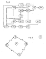
- an internal digital map 101 is provided.
- a positioning device 102 provided with various sensors, such as, for example, a GPS antenna, speedometer signal, the vehicle position is assigned with high precision to a section of the digital map 101 when the vehicle is in the network stored on the map.
- the navigation system Via an input device 103, the navigation system can be given a destination. This is verified via a destination input memory 104 and possibly identified as belonging to the internal digital map 101.
- the destination input memory 104 and the internal digital map 101 are expediently stored on the same data carrier, such as a CDROM.
- a routing algorithm 105 calculates an internally calculated route or route portion from the vehicle position or a starting location to the destination and stores this route in an internal route memory 106.
- the starting location does not necessarily coincide with a current location of the motor vehicle. For example, the vehicle moves during the route query, so that after completion of route calculation and transmission, the motor vehicle has already arrived at a position spaced from the start location.
- an internal destination guidance algorithm 107 outputs via output devices 108 both the route, the vehicle position and driving instructions to the destination. This process is repeated continuously until the route guidance is canceled or the destination is reached.
- a remote data transmission device 109 is also provided in order to exchange information via communication networks 201 with a traffic telematics center. With traffic congestion information thus obtained, the routing algorithm 105 generates congestion avoidance routes.
- the center or the off-board navigation system comprises an external digital map 301, an external routing algorithm 302 and an input / output functions 303, such as a device for remote data transmission for input of start and end position and for outputting the calculated route.
- a route or route component calculated externally by the off-board navigation system is entered in an external route memory 110.
- the route guidance takes place here with its own external route guidance algorithm 111.
- the input device 103 and the destination input memory 104 are expanded so that not only destinations on the internal digital map 101 can be input.
- both the Intemrouten acknowledged 106 (for autonomous route shares) and the Extemrouten immediately 110 (for off-board route portions) to keep in stock.
- the internal route guidance algorithm 107 (map-based) and the extra route guidance algorithm 111 are to be executed in duplicate.
- a switching device 112 of the hybrid system which is designed, for example, as a software switch, is switched while driving at transfer nodes from the autonomous to the off-board route guidance and back.
- the output devices 108 and communication device 109 can be used for both modes.
- both the autonomous and off-board navigation work in the "tum by turn” method.
- indications of the actions to be carried out are generated graphically or by voice output ("Turn right onto the B8", “Turn right onto the B8").
- Fig. 2 shows by way of example an internal digital map 101 in the vehicle with the nodes K1 to K4 contained therein and edges K12, K13, K24 and K34. These form the area in which autonomous navigation is possible. Furthermore, six off-board referenceable nodes Z1 to Z6 are listed. For example, via appropriate software, such as look-up tables, the nodes K1 to K4 are identified as identical to Z1 to Z4. For example, after off-board calculation of a direct route from Z1 to Z2, this is detected in the vehicle internally as identical to the independently calculable route running over edge K12 from K1 to K2
- the software switch 112 switches at any point from the internal route guidance device 107 to the external route guidance device 111 and back.
- both destination guides or algorithms 107, 111 are active at the same time, are supplied with data by the locating device 102, and during the journey already passed sections of the respective route memory 106 or 110 are marked as deleted or deleted.
- Particularly advantageous here is an automatically performed change from autonomous to off-board at transfer nodes, in which the area of the internal digital map 101 is left. For example, this could occur in the following case.
- a route from K1 or Z1 to Z6 is planned.
- a corresponding route in the autonomous system can not be planned or calculated because Z6 is not included in the internal digital map 101.
- Off-board would calculate the route Z1>Z2>Z4> Z6. By evaluating similarities, this route is analyzed. Since Z1 and Z4 can be assigned to the map nodes K1 and K4, internally an internal route share K1>K2> K4 is calculated and stored in the autonomous route memory 106.
- the software switch 112 is further provided with a rule such that, upon receipt of off-board calculated route shares, these route portions lying on the internal digital map 101 are recognized and autonomous route shares are calculated for this purpose. If both methods are then possible on a section of the route, the autonomous method is advantageously used in an advantageous manner.
- the use of the internally calculated route share allows more precise driving instructions by means of map-based locating.
- the behavior for returning to the planned route in this case is more comfortable because of the knowledge of the road network of the internal digital map 101. This is relevant in the case of intentional or unintentional departure from the planned route. If it is detected that there is no longer a possibility for autonomous route guidance, then the switch 112 switches over to the off-board route.
- an associated network transition node is stored for each destination present in the destination input memory 104 and not contained in the internal digital map 101. For example, if Z6 is input at the destination input, then K4 is found to be the associated transition point because it is stored in the destination input memory 104 as such. The route from K1 to K4 is then calculated autonomously and the route from Z4 to Z6 is requested for an off-board calculation.
- Fig. 3 shows a corresponding sequence. In the Fig.
- 3 to 5 10 denotes the vehicle-side navigation system, 12 a message transmitted via the data communication device 109, and 14 the off-board navigation system.
- the memory content of the destination input memory 104 is used to locate K4 as the local transfer node to Z6.
- a route from Z4 to Z6 is requested.
- the route Z4> Z6 is calculated in the off-board navigation system 14.
- the route Z4> Z6 is transmitted from the off-board navigation system 14 to the navigation system 10 in the vehicle.
- the internal route share K1> K4 is calculated and at 26 the route guidance starts.
- the necessary handover nodes are negotiated using a data protocol between hybrid navigation system 10 and off-board navigation system 14 based on geographical descriptions of nodes located outside the digital map, as in FIG Fig. 4 shown.
- the assignment of the transfer node K4 to the destination Z6 is not stored in the destination input memory 104. That's how it gets Fig. 4 can be seen, after entering the destination Z6 via remote data transmission 28, the destination at 30 identified in the off-board navigation system 14 and the approximate location of the target Z6 transmitted to the vehicle at 32 back and then there with the aid of a corresponding allocation algorithm at 34 the nearest transfer node K4 assigned.
- Fig. 5 1 illustrates, for identification of the transfer node in the route calculation request 18, to introduce control information with a possibility of identifying the version of the internal digital map 101.
- This information is then used off-board to identify the necessary transition nodes at 36.
- the request 18 is for a route from Z1 to Z6 with digital card V1.
- the route Z4 to Z6 is then transmitted by the off-board navigation system 14 to the internal navigation system 10 and informed that an internal route calculation has to be made by K4. This is done in 24 and in 26 the route guidance starts again.
- control information also exists from a list of possible transition points generated in the hybrid navigation system 10.
- the off-board navigation system 14 selects the transfer node to be used.
- Z5 is transmitted as a destination to the off-board navigation system 14.
- the position of Z5 is detected and then transmitted to the internal navigation system 10.
- the nodes K2 and K3 are identified as possible transfer nodes and transmitted to the off-board navigation system 14 in the subsequent communication step.
- the route Z2 is calculated to Z5 and then transmitted together with the transfer node K2 to the internal navigation system 10. This then states that an internal route share from K1 to K2 has to be calculated.
- the coding of the transfer nodes consists, for example, of geocodes according to GATS, TMC locations according to prENV 12313-3 or ERTICO ILOCs.
- the route memories 106 and 110 are combined into a single one.
- the implementation of a hybrid system according to the invention is described below using the example of a navigation system with dynamic APS (dynAPS).
- the destination is entered there either by an input device, the goals in the order "city”, possibly “district”, “street name”, “intersection or
- the possible destinations are thereby extracted from a destination input memory 104 on the CD-ROM with the internal digital map 101.
- a destination input memory 104 on the CD-ROM with the internal digital map 101.
- this destination input memory 104 is extended by additional information, cf. Fig. 4 , For the entry Paris (France), lists of possible transition nodes and rules for their selection are stored in the destination input memory 104 of the CD-ROM. For example, in the case of a Germany CD-ROM, the transfer node "A44 Aachen-Lichtenbusch" is selected for a vehicle position "North Rhine-Westphalia". This happens without the driver being able to recognize this. After entering the destination, for example, the driver has selected the "Telematics / Hybrid Route" function in the navigation settings.
- the distance to the next driving maneuver is displayed on a screen.
- a pictogram of the location of this maneuver appears with the entered expected route. This would be approaching the motorway junction Aachen on the A4 coming from Cologne only the distance to the motorway junction Aachen and when approaching a picture which "right drive out" signaled.
- the driving instructions are also spoken on approach.
- the hybrid APS When requesting a route via SMS, the hybrid APS also sends an ID to the GATS control center in addition to the start position and desired destination using the inserted CD-ROM (data scope, version), cf. Fig. 5 , It can now be recognized in the GATS central to which transition node the internal digital map 101 is to be routed.
- the invention relates to a navigation system for route guidance in a vehicle wherein the route stored for a navigation system in the navigation system proportionally from in the vehicle with data of a digital map 101 (autonomously) calculated and obtained from an external routing 302 (off-board) calculated route sections together is set.
- the externally determined portions need not necessarily be included in the digital map 101 used in the vehicle for routing.
- a further advantage is a design such that the switching between the centrally or autonomously calculated sections is either controlled by a user or unnoticed unnoticed in the background, which are provided for automatic switching in the background in the route memory, the individual route sections with control information, which control the switching ,
- a uniform user interface is used to output driving instructions and the route, regardless of which type of route section is currently being passed by the vehicle.
- the double design of the route memory 106, 110 is advantageous, with one route memory 110 containing the centrally externally calculated route and the other route memory 106 including the autonomously internally calculated route and, on the basis of control information, switching from one to the other route memory as required.
- the transmission of externally determined shares via a remote data transmission device 109, for example by data radio in a mobile network, such as the SMS transmission in the GSM. In this case, the transmission can be directed unilaterally into the vehicle (broadcast) or use bidirectional data traffic.
- the externally calculated fractions can be transferred to GATS Appendix 5.3.1 and 5.3.2, using GATS Geocodes, using TMC locations, using ERTICO IL0Cs or other methods.
- the externally calculated route is also fed via a serial line or infrared interface, a network interface or by using an externally described and read in the navigation system disk (floppy disk, PCMCIA card, ).
- the automatic generation of the control information is such that upon receipt of an externally determined route, the portions of the route, which are clearly assignable to the in-vehicle digital map, are replaced after receipt by calculated in the vehicle shares.
- the transmission of information about the in-vehicle digital map 101 to use this version information in the external route calculation to externally determine only the non-computable in the vehicle portions of the route and to transfer into the vehicle while the remaining shares calculated in the vehicle become.
- a query is automatically or manually generated to calculate an external route calculation, and the result of this calculation is then used to return to the digitized road network 101 or to route to the destination. If a route guidance with the help of the digital map 101 is possible, then advantageously switched by the route guidance using an external route to the autonomously calculated route guidance. If a route guidance with the aid of the digital map 101 is no longer possible and the vehicle position can be assigned to the route obtained externally, then switching from the autonomous route guidance to the external route is advantageously effected
Landscapes
- Engineering & Computer Science (AREA)
- Radar, Positioning & Navigation (AREA)
- Remote Sensing (AREA)
- Physics & Mathematics (AREA)
- General Physics & Mathematics (AREA)
- Automation & Control Theory (AREA)
- Navigation (AREA)
- Instructional Devices (AREA)
Description
Die Erfindung betrifft ein Verfahren zur Navigation von einem Startort, insbesondere einem momentanen Standort, zu einem Zielort, wobei ein Routing-Algorithmus eines Navigationssystems für ein Fortbewegungsmittel, insbesondere ein Kraftfahrzeug, Schiff oder Flugzeug, eine Route vom Startort zum Zielort über auf einer digitalen Karte gespeicherte Knotenpunkte berechnet, gemäß dem Oberbegriff des Anspruchs 1. Die Erfindung betrifft ferner ein Navigationssystem für ein Fortbewegungsmittel, insbesondere ein Kraftfahrzeug, Schiff oder Flugzeug, mit einem Internroutenspeicher, einer mit diesem verbunden Internzielführungseinrichtung, einer internen digitalen Karte und einer Datenkommunikationseinrichtung zur Kommunikation mit einem externen Off-Board-Navigationssystem, gemäß dem Oberbegriff das Anspruchs 12.The invention relates to a method for navigating from a starting location, in particular a current location, to a destination, wherein a routing algorithm of a navigation system for a means of transportation, in particular a motor vehicle, ship or aircraft, a route from the starting place to the destination via on a digital map The invention further relates to a navigation system for a means of locomotion, in particular a motor vehicle, ship or aircraft, having an intern route memory, an internally directed thereto, an internal digital map and a data communication device for communicating with a external off-board navigation system, according to the preamble of
Navigationssysteme, beispielsweise solche in Kraftfahrzeugen, basieren auf digitalen Karten, welche in Festwertspeichern mitgeführt werden. Da sich alle Funktionselemente im Fahrzeug befinden, werden diese Navigationssysteme als autonome Navigationssysteme klassifiziert. Weiterhin sind Navigationssysteme bekannt, bei denen die Routen außerhalb eines eigentlichen Zielführungssystems berechnet werden. Beispielsweise wird die von einem Fahrzeug zu fahrende Route in einer Verkehrstelematik Zentrale berechnet. Diese sogn. Off-Board-Navigationssysteme haben den Vorteil, dass der Einsatzbereich nicht von vornherein durch Umfang und Aktualisierungsstand der mitgeführten digitalen Karte eingeschränkt wird. Andererseits kann nur durch einen zur Zeit wirtschaftlich nicht realisierbaren Kommunikationsaufwand die Geschwindigkeit, der Komfort und die Präzision eines autonomen Navigationssystems erreicht werden.Navigation systems, for example those in motor vehicles, are based on digital maps, which are carried in read-only memories. Since all functional elements are in the vehicle, these navigation systems are classified as autonomous navigation systems. Furthermore, navigation systems are known in which the routes are calculated outside of an actual route guidance system. For example, the route to be traveled by a vehicle is calculated in a traffic telematics center. These sogn. Off-board navigation systems have the advantage that the area of use is not limited from the outset by the size and the level of updates of the entrained digital map. On the other hand, the speed, the comfort and the precision of an autonomous navigation system can only be achieved by means of a communication effort that is currently not economically viable.
Herkömmliche Navigationssysteme haben jedoch den Nachteil, dass lediglich entweder eine vollständig autonome Routenberechnung oder eine vollständige externe bzw. Off-Board-Routenberechnung erfolgt mit den jeweils oben geschilderten Nachteilen.However, conventional navigation systems have the disadvantage that only either a completely autonomous route calculation or a complete external or off-board route calculation takes place with the respective disadvantages described above.
Die
Es ist Aufgabe der vorliegenden Erfindung, ein verbessertes Navigationsverfahren und ein verbessertes Navigationssystem der obengenannten Art zur Verfügung zu stellen, welche die obengenannten Nachteile beseitigen.It is an object of the present invention to provide an improved navigation method and an improved navigation system of the aforementioned kind, which eliminate the above-mentioned disadvantages.
Diese Aufgabe wird durch ein Navigationsverfahren der o.g. Art mit den in Anspruch 1 gekennzeichneten Merkmalen und durch ein Navigationssystem der o.g. Art mit den in Anspruch 12 gekennzeichneten Merkmalen gelöst.This task is accomplished by a navigation procedure of the o.g. Art having the features characterized in claim 1 and by a navigation system of the o.g. Art solved with the features characterized in
Dazu ist es bei einem Navigationsverfahren der o.g. Art erfindungsgemäß vorgesehen, dass entweder ein Internzielführungsalgorithrus des Navigationssystems eine Zielführung auf der Basis-des intern berechneten Routenanteils oder ein Externzielführungsalgorithmus eine Zielführung auf der Basis des extern berechneten Routenanteils durchführt je nach dem ob sich das Fortbewegungsmittel innerhalb oder außerhalb des Bereiches der internen digitalen Karte (101) befindet.For this it is in a navigation method og. Art according to the invention provided that either an internal Zielführungsgorgurus of the navigation system, a route guidance on the basis of internally calculated route share or an external guidance algorithm performs a route guidance based on the externally calculated route share depending on whether the means of locomotion within or outside the range of the internal digital map ( 101) is located.
Dies hat den Vorteil, dass ein hybrides Navigationssystem zur Verfügung steht, wobei, so weit möglich, bei der Zielführung die detaillierten Informationen der internen digitalen Karte Verwendung finden und lediglich in Bereichen, welche außerhalb der internen digitalen Karte liegen, eine Zielführung auf der Basis einer extern gespeicherten digitalen Karte verwendet werden. Dadurch werden erfindungsgemäß die Vorteile eines autonomen Navigationssystems, nämlich eine hohe Zielführungsgenauigkeit, mit den Vorteilen eines Off-Board-Navigationssystems, nämlich keine Bereichsbegrenzung aufgrund der digitalen Kartenbasis, vereint. Gleichzeitig werden die Nachteile eines autonomen Navigationssystems, nämlich Navigationsführung ausschließlich innerhalb der intern gespeicherten digitalen Karte, sowie die Nachteile eines Off-Board-Navigationssystems, nämlich hohe Übertragungskosten durch große zu übertragende Datenmengen, vermieden. Somit stehen einem Benutzer die Vorteile des "Off-Board"Navigationssystems und des autonomen Navigationssystems unter einer einheitlichen Bedienoberfläche mit jeweils bestmöglicher Funktion zur Verfügung.This has the advantage that a hybrid navigation system is available, where, as far as possible, find the detailed information of the internal digital map in the route guidance and only in areas that are outside the internal digital map, a guidance based on a externally stored digital map. As a result, according to the invention, the advantages of an autonomous navigation system, namely high guidance accuracy, are combined with the advantages of an off-board navigation system, namely no range limitation on the basis of the digital map base. At the same time, the disadvantages of an autonomous navigation system, namely navigation guidance exclusively within the internally stored digital map, as well as the disadvantages of an off-board navigation system, namely high transmission costs due to large amounts of data to be transmitted, are avoided. Thus, a user has the advantages of the "off-board" navigation system and the autonomous navigation system under a uniform user interface with the best possible function available.
Vorzugsweise Weitergestaltungen des Navigationsverfahrens sind in den Ansprüchen 2 bis 11 beschrieben.Preferably, further developments of the navigation method are described in
In einer bevorzugten Ausführungsform wird zunächst vom externen Routing-Algorithmus die vollständige Route berechnet, an das Navigationssystem übertragen und anschließend vom internen Routing-Algorithmus derjenige Routenanteil, welcher ausschließlich in der internen digitalen Karte gespeicherte Knotenpunkte umfasst, berechnet und der entsprechende Teil der extern berechneten Route durch den intern berechneten Routenanteil ersetzt.In a preferred embodiment, the complete route is first calculated by the external routing algorithm, transmitted to the navigation system, and then calculated by the internal routing algorithm that portion of the route which exclusively contains nodes stored in the internal digital map and the corresponding part of the externally calculated route replaced by the internally calculated route share.
Zur Reduktion von Kommunikationskosten und Übertragungsszeit erzeugt zuerst der interne Routing-Algorithmus die intern berechnete Route, überträgt Informationen über noch fehlende Teile der Route, insbesondere noch fehlende Knotenpunkte und Übergabeknotenpunkte, an den externen Routing-Algorithmus, berechnet der externe Routing-Algorithmus lediglich die noch fehlenden Routenanteile und überträgt diese an das Navigationssystem.To reduce communication costs and transmission time, the internal routing algorithm first generates the internally calculated route, transmits information about missing parts of the route, in particular still missing nodes and transfer nodes, to the external routing algorithm, the external routing algorithm only calculates the still missing route shares and transmits them to the navigation system.
In einer bevorzugten Ausführungsform wird der intern berechnete Routenanteil im Navigationssystem in einem Internroutenspeicher und der extern berechnete Routenanteil im Navigationssystem in einem Externroutenspeicher abgespeichert, wobei entweder ein Internzielführungsalgorithmus des Navigationssystems eine Zielführung auf der Basis der Route im Internroutenspeicher oder ein Externzielführungsalgorithmus des Navigationssystems eine Zielführung auf der Basis der Route im Externroutenspeicher durchführt.In a preferred embodiment the internally calculated route share in the navigation system is stored in an internal route memory and the externally calculated route share in the navigation system in an external route memory, either an internal navigation guidance system based on the route in the internal route memory or an external guidance algorithm of the navigation system based on the route in the external route memory performs.
Zweckmäßigerweise wird bei Erreichen eines Übergabeknotenpunktes vom Internzielführungsalgorithmus auf den Externzietführungsalgorithmus umgeschaltet, wenn das Fortbewegungsmittel den Bereich der internen digitalen Karte verlässt, bzw. vom Externzielführungsalgorithmus auf den Internzielführungsalgorithmus umgeschaltet, wenn das Fortbewegungsmittel den Bereich der internen digitalen Karte erreicht.Conveniently, upon reaching a handover node, the internal targeting algorithm switches to the external tenant routing algorithm when the means of locomotion leaves the internal digital card area or switches from the external guidance algorithm to the internal targeting algorithm when the means of locomotion reaches the area of the internal digital map.
Jederzeit aktuelle Daten sowohl im Internroutenspeicher als auch im Externroutenspeicher erzielt man dadurch, dass während der Zielführung bereits erreichte Knotenpunkte bzw. passierte Abschnitte der Route sowohl im Internroutenspeicher als auch im Externroutenspeicher als erledigt bzw. passiert gekennzeichnet oder gelöscht werden, unabhängig davon, welcher Zielführungsalgorithmus gerade aktiv ist.Anytime up-to-date data both in the internal route memory and in the external route memory is achieved by marking or deleting already reached nodes or passages of the route in the internal route memory as well as in the external route memory, regardless of which route guidance algorithm is currently being used is active.
Für eine schnelle Zuordnung von Knotenpunkten an die interne Karte oder die Externe Karte und zum schnellen Auffinden von entsprechenden Übergabeknotenpunkten werden in einem Zieleingabespeicher des Navigationssystems sowohl in der internen digitalen Karte gespeicherte, interne Knotenpunkte als auch außerhalb des Bereichs der internen digitalen Karte befindliche externe Knotenpunkte gespeichert, wobei zu vorbestimmten externen Knotenpunkten wenigstens ein Übergabeknotenpunkt abgespeichert wird, wobei der Übergabeknotenpunkt ein in der internen digitalen Karte enthaltener interner Knotenpunkt ist.For quick allocation of nodes to the internal card or the external card and to quickly find corresponding transfer nodes are stored in a destination input memory of the navigation system both stored in the internal digital card, internal nodes as well as located outside the range of internal digital card external nodes wherein at predetermined external nodes at least one transfer node is stored, wherein the transfer node is an internal node included in the internal digital map.
Für eine optimale Auswahl von Übergabeknoten werden in einem gesonderten Kommunikationsschritt zwischen dem Navigationssystem und einem Off-Board-Navigationssystem, welches den externen Routing-Algorithmus ausführt und die externe digitale Karte speichert, die notwendigen Übergabeknotenpunkte mittels eines Datenprotokolls anhand von geographischen Beschreibungen von außerhalb der internen digitalen Karte liegenden Knotenpunkten bestimmt.For an optimal selection of handover nodes, in a separate communication step between the navigation system and an off-board navigation system, which executes the external routing algorithm and stores the external digital map, the necessary handover nodes are identified by means of a data protocol based on geographical descriptions from outside the internal determined digital node lying nodes.
In einer vorteilhaften Ausführungsform überträgt nach einer Eingabe eines Zielortes, welcher außerhalb des Bereichs der internen digitalen Karte liegt, das Navigationssystem an ein Off-Board-Navigationssystem, welches den externen Routing-Algorithmus ausführt und die externe digitale Karte speichert, den eingegebenen Zielort und eine Versionsnummer der internen digitalen Karte, wobei das Off-Board-Navigationssystem aus diesen Informationen einen Übergabeknotenpunkt bestimmt, von dem aus zum eingegebenen Zielort der extern berechnete Routenanteil von dem externen Routing-Algorithmus berechnet und an das Navigationssystem übertragen wird.In an advantageous embodiment, after an entry of a destination which is outside the range of the internal digital map, the navigation system transmits to an off-board navigation system which executes the external routing algorithm and stores the external digital map, the input destination and a Version number of the internal digital map, the off-board navigation system from this information determines a transfer node from which the externally calculated route share is calculated by the external routing algorithm to the input destination and transmitted to the navigation system.
Zweckmäßigerweise überträgt das Navigationssystem an ein Off-Board-Navigationssystem, welches den externen Routing-Algorithmus ausführt und die externe digitale Karte speichert, eine Liste von möglichen Übergabeknotenpunkten, wobei das Off-Board-Navigationssystem gemäß dem extern berechneten Routenanteil wenigstens einen geeigneten Übergabeknotenpunkt auswählt und mit dem extern berechneten Routenanteil an das Navigationssystem überträgt.Conveniently, the navigation system transmits to an off-board navigation system, which executes the external routing algorithm and stores the external digital map, a list of possible handover nodes, wherein the off-board navigation system selects at least one suitable handover node according to the externally calculated route share transmits to the navigation system with the externally calculated route share.
In einer bevorzugten Ausführungsform erfolgt die Berechnung des extern berechneten Routenanteils dann, wenn das Fortbewegungsmittel einen Bereich der internen digitalen Karte verlässt.In a preferred embodiment, the calculation of the externally calculated route component takes place when the means of locomotion leaves a region of the internal digital map.
Bei einem Navigationssystem der o.g. Art ist es erfindungsgemäß vorgesehen, dass ein mit der Datenkommunikationseinrichtung verbundener Externroutenspeicher sowie eine mit diesem verbundene Externzielführungseinrichtung vorgesehen ist, wobei ferner eine Schalteinrichtung vorgesehen ist, welche während einer Zielführung wahlweise die Externzielführungseinrichtung oder die Internzielführungseinrichtung aktiviert, je nach dem ob sich das Fortbewegungsmittel innerhalb oder außerhalb des Bereiches der internen digitalen Karte befindet.In a navigation system of o.g. It is provided according to the invention that an external route memory connected to the data communication device is provided, and a switching device is provided which optionally activates the external destination guide device or the internal destination guide device during a route guidance, depending on whether the means of transportation within or is outside the range of the internal digital map.
Dies hat den Vorteil, dass ein hybrides Navigationssystem zur Verfügung steht, wobei, so weit möglich, bei der Zielführung die detaillierten Informationen der internen digitalen Karte Verwendung finden und lediglich in Bereichen, welche außerhalb der internen digitalen Karte liegen, eine Zielführung auf der Basis einer extern gespeicherten digitalen Karte verwendet werden. Dadurch werden erfindungsgemäß die Vorteile eines autonomen Navigationssystems, nämlich eine hohe Zielführungsgenauigkeit, mit den Vorteilen eines Off-Board-Navigationssystems, nämlich keine Bereichsbegrenzung aufgrund der digitalen Kartenbasis, vereint. Gleichzeitig werden die Nachteile eines autonomen Navigationssystems, nämlich Navigationsführung ausschließlich innerhalb der intern gespeicherten digitalen Karte, sowie die Nachteile eines Off-Board-Navigationssystems, nämlich hohe Übertragungskosten durch große zu übertragende Datenmengen, vermieden. Somit stehen einem Benutzer die Vorteile des Off-Board-Navigationssystems und des autonomen Navigationssystems unter einer einheitlichen Bedienoberfläche mit jeweils bestmöglicher Funktion zur Verfügung.This has the advantage that a hybrid navigation system is available, where, as far as possible, find the detailed information of the internal digital map in the route guidance and only in areas that are outside the internal digital map, a guidance based on a externally stored digital map. As a result, according to the invention, the advantages of an autonomous navigation system, namely high guidance accuracy, are combined with the advantages of an off-board navigation system, namely no range limitation on the basis of the digital map base. At the same time, the disadvantages of an autonomous navigation system, namely navigation guidance exclusively within the internally stored digital map, as well as the disadvantages of an off-board navigation system, namely high transmission costs due to large amounts of data to be transmitted, are avoided. Thus, the advantages of the off-board navigation system and the autonomous navigation system are available to a user under a uniform user interface, each with the best possible function.
Eine vorzugsweise Weitergestaltung des Navigationssystems ist in Anspruch 13 beschrieben. Hierbei sind der Intemroutenspeicher und der Extemroutenspeicher zu einem einzigen Speicher zusammengefasst.A preferred refinement of the navigation system is described in claim 13. In this case, the Intemroutenspeicher and the Extemroutenspeicher are combined into a single memory.
Nachstehend wird die Erfindung anhand der beigefügten Zeichnungen näher erläutert. Diese zeigen in
- Fig. 1
- ein schematisches Blockschaltbild einer bevorzugten Ausführungsform eines erfindungsgemäßen Navigationssystems,
- Fig. 2
- einen Ausschnitt einer internen digitalen Karte des Navigationssystems von
Fig. 1 und - Fig. 3 bis 5
- verschiedene Kommunikationsschritte bzw. Kommunikationsabläufe zwischen einem Navigationssystem und einem Off-Board-Navigationssystem.
- Fig. 1
- a schematic block diagram of a preferred embodiment of a navigation system according to the invention,
- Fig. 2
- a section of an internal digital map of the navigation system of
Fig. 1 and - Fig. 3 to 5
- various communication steps or communication sequences between a navigation system and an off-board navigation system.
Bei dem in
Durch einen kontinuierlich durchgeführten Vergleich der durch die Ortungseinrichtung 102 erfassten Fahrzeugposition mit der gespeicherten Route und unter Zuhilfenahme der digitalen Karte 101 werden von einem Internzielführungsalgorithmus 107 über Ausgabeeinrichtungen 108 sowohl die Fahrtroute, die Fahrzeugposition als auch Fahranweisungen zum Ziel ausgegeben. Dieser Vorgang wird kontinuierlich wiederholt, bis die Zielführung abgebrochen oder das Ziel erreicht wird. Es ist ferner eine Datenfernübertragungseinrichtung 109 vorgesehen, um Informationen über Kommunikationsnetze 201 mit einer Verkehrstelematik-Zentrale auszutauschen. Mit solcherart erhaltenen Information über Verkehrsstaus generiert der Routing-Algorithmus 105 Routen zur Umfahrung von Staus. Die Zentrale bzw. das Off-Board-Navigationssystem umfasst eine externe digitale Karte 301, einen externen Routings-Algorithmus 302 sowie eine Ein-/Ausgabefunktionen 303, etwa eine Einrichtung zur Datenfernübertragung zur Eingabe von Start und Zielposition sowie zur Ausgabe der berechneten Route. In der Zentrale werden optional durch eine Dynamisierungsfunktion Informationen über aktuelle und prognostizierte Verkehrsstörungen zur Routensuche verwendet. Eine von dem Off-Board-Navigationssystem extern berechnete Route bzw. Routenanteil wird in einen Externroutenspeicher 110 eingetragen. Die Zielführung erfolgt hierbei mit einem eigenen Externzielführungsalgorithmus 111.Through a continuous comparison of the vehicle position detected by the locating device 102 with the stored route and with the aid of the
Bei dem erfindungsgemäßen hybriden Navigationssystem sind die Eingabeeinrichtung 103 und der Zieleingabespeicher 104 derart erweitert, dass nicht nur Ziele auf der internen digitalen Karte 101 eingeben werden können. Bei Beginn der Zielführung kann dann zwischen den Möglichkeiten "autonome Zielführung", "Off-Board Zielführung" und "hybride Zielführung" gewählt werden. Hierzu sind sowohl der Intemroutenspeicher 106 (für autonome Routenanteile) und der Extemroutenspeicher 110 (für Off-Board Routenanteile) vorrätig zu halten. Weiterhin sind der Internzielführungsalgorithmus 107 (kartenbasierend) und der Extemzielführungsalgorithmus 111 (off-board, zum Beispiel nach GATS) doppelt auszuführen. Über eine Schaltvorrichtung 112 des hybriden Systems, welcher beispielsweise als Softwareschalter ausgebildet ist, wird während einer Fahrt an Übergabeknotenpunkten von der autonomen auf die Off-Board Zielführung und zurück geschaltet. Die Ausgabeeinrichtungen 108 und Kommunikationseinrichtung 109 können für beide Betriebsarten genutzt werden.In the hybrid navigation system according to the present invention, the
Zur gemeinsamen Nutzung der Ausgabeeinrichtung 108 arbeiten sowohl die autonome als auch Off-Board Navigation im "Tum by Turn"-Verfahren. Bei so einem Verfahren werden bei Annäherung an beispielsweise eine Kreuzung in den Fahranweisungen Hinweise auf die durchzuführenden Aktionen grafisch oder per Sprachausgabe erzeugt ("Demnächst rechts auf die B8 abbiegen", "Jetzt rechts auf die B8 abbiegen").For the common use of the
Befindet sich das Navigationssystem auf einer geplanten Zielführung von K1 oder Z1 nach K2 oder Z2 so schaltet der Softwareschalter 112 an jedem beliebigen Punkt von der Internzielführungseinrichtung 107 auf die Externzielführungseinrichtung 111 und zurück. Hierzu sind beide Zielführeinrichtungen bzw. -algorithmen 107, 111 gleichzeitig aktiv, werden von der Ortungseinrichtung 102 mit Daten versorgt und während der Fahrt werden bereits passierte Abschnitte der jeweiligen Routenspeicher 106 bzw. 110 als passiert markiert oder gelöscht. Besonders vorteilhaft ist hierbei ein automatisch durchgeführter Wechsel von autonom nach Off-Board an Übergabeknotenpunkten, bei denen der Bereich der internen digitalen Karte 101 verlassen wird. Beispielsweise könnte dieses in folgendem Fall auftreten. Es wird eine Route von K1 bzw Z1 nach Z6 geplant. Eine entsprechende Route im autonomen System kann nicht geplant bzw. berechnet werden, da Z6 nicht in der internen digitalen Karte 101 enthalten ist. Off-Board würde die Route Z1 > Z2 > Z4 > Z6 berechnet. Durch Auswertung von Ähnlichkeiten wird diese Route analysiert. Da Z1 und Z4 den Kartenknoten K1 und K4 zugeordnet werden kann, wird intern ein interner Routenanteil K1 > K2 > K4 berechnet und im autonomen Routenspeicher 106 abgespeichert. Der Softwareschalter 112 wird ferner mit einer Regel derart versehen, dass beim Erhalt von Off-Board berechneten Routenanteilen diese auf der internen digitalen Karte 101 liegenden Routenanteile erkannt und hierfür autonome Routenanteile berechnet werden. Wenn dann auf einem Abschnitt der Route beide Verfahren möglich sind, so wird in vorteilhafter Weise bevorzugt das autonome Verfahren benutzt. Die Verwendung des intern berechneten Routenanteils erlaubt durch kartenbasierte Ortung präzisere Fahranweisungen. Auch ist das Verhalten zur Rückführung auf die geplante Route in diesem Fall, wegen der Kenntnis des Straßennetzes der internen digitalen Karte 101, komfortabler. Dies ist im Fall eines gewollten oder ungewollten Abweichens von der geplanten Route relevant. Wenn erkannt wird, daß keine Möglichkeit zur autonomen Zielführung mehr besteht, dann wird vom Schalter 112 auf die Off-Board Route umgeschaltet. in dem dargestellten Beispiel führt dies im erfindungsgemäßen hybriden Navigationssystem bei einer Navigationsführung von Z1 nach Z6 zu folgender durchgeführten Route: K1 > K2 > K4; Umschaltung von autonom nach Off-Board; Z4 > Z6.Is the navigation system on one planned route guidance from K1 or Z1 to K2 or Z2, the
Sinngemäß wird dieser Mechanismus umgekehrt auch beim Verlassen eines Off-Board Streckenanteiles angewandt. Bei der Rückfahrt von Z6 nach K1 würde am Knoten Z4 oder K4 die Möglichkeit der autonomen Routenberechnung erkannt werden. Die Route wäre dann folgendermaßen: Z6 > Z4; Umschaltung Off-Board nach autonom; K4 > K2 > K1.By analogy, this mechanism is applied conversely also when leaving an off-board track share. On the return journey from Z6 to K1, the possibility of autonomous route calculation would be recognized at node Z4 or K4. The route would then be as follows: Z6> Z4; Switching off-board to autonomous; K4> K2> K1.
Da die Übertragung von Off-Board Routen Kommunikationskosten und Übertragungszeit erzeugt, ist es vorteilhaft, bei der Anforderung von Routen-Berechnungen die Anteile aus der Berechnung ausschließen, bei denen die Route autonom gerechnet werden kann. Hierzu wird zu jedem im Zieleingabespeicher 104 vorhandenen und nicht in der internen digitalen Karte 101 enthaltenem Ziel ein zugehöriger Netz-Übergangsknotenpunkt gespeichert. Wenn beispielsweise bei der Zieleingabe Z6 eingegeben wird, dann wird K4 als der zugehörige Übergangspunkt aufgefunden, weil dieser im Zieleingabespeicher 104 als solcher mit abgespeichert ist. Es wird dann die Route von K1 nach K4 autonom berechnet und die Route von Z4 nach Z6 für eine Off-Board Berechnung angefordert.
Alternativ werden in einem gesonderten Kommunikationsschritt die notwendigen Übergabeknotenpunkte mit Hilfe eines Datenprotokolles zwischen hybriden Navigationssystem 10 und Off-Board-Navigationssystem 14 anhand von geographischen Beschreibungen von außerhalb der digitalen Karte liegenden Knoten ausgehandelt, wie in
Wenn die im Navigationssystem 10 vorhandene interne digitale Karte 101 auch im für die Off-Board Berechnung verwendeten Gerät 14 vorhanden ist, dann genügt es, wie in
Alternativ besteht die Steuerinformation auch aus einer im hybriden Navigationssystem 10 erzeugten Liste von möglichen Übergangspunkten. Das Off-Board-Navigationssystem 14 wählt dann den zu verwendenden Übergabeknotenpunkt aus. In einem ersten Kommunikationsschritt wird Z5 als Ziel an das Off-Board-Navigationssystem 14 übertragen. In einem weiteren Schritt wird die Position von Z5 festgestellt und danach an das interne Navigationssystem 10 übertragen. Im folgenden Schritt werden die Knoten K2 und K3 als mögliche Übergabeknotenpunkte identifiziert und im darauffolgen Kommunikationsschritt an das Off-Board-Navigationssystem 14 übertragen. Im nächsten Schritt wird die Route Z2 nach Z5 berechnet und danach zusammen mit dem Übergabeknotenpunkt K2 an das interne Navigationssystem 10 übertragen. Dieses stellt danach fest, dass ein interner Routenanteil von K1 nach K2 zu berechnen ist.Alternatively, the control information also exists from a list of possible transition points generated in the
Die Codierung der Übergabeknotenpunkte besteht beispielsweise aus Geocodes nach GATS, TMC Locations nach prENV 12313-3 oder aus ERTICO ILOCs. In einer alternativen Ausführungsform sind die Routenspeicher 106 und 110 zu einem einzigen kombiniert. Bei autonom "fahrbaren" Anteilen stehen dort Hinweise auf die Anbindung an die eigene digitale Karte und bei "Off-Board"-Anteilen Hinweise auf Korridore entsprechend GATS Protokoll.The coding of the transfer nodes consists, for example, of geocodes according to GATS, TMC locations according to prENV 12313-3 or ERTICO ILOCs. In an alternative embodiment, the
Die Realisierung eines erfindungsgemäßen Hybridsystems wird nachfolgend am Beispiel eines Navigationssystems mit dynamischem APS (dynAPS) beschrieben.Die Zieleingabe erfolgt dort entweder indem über eine Eingabeeinrichtung die Ziele in der Reihenfolge "Stadt", ggf. "Stadtteil", "Straßenname", "Kreuzung oder Hausnummer durch Buchstabieren und Auswahl aus Listen oder Kombinationen hieraus eingeben werden. Die möglichen Ziele werden dabei einem Zieleingabespeicher 104 auf der CD-ROM mit der internen digitalen Karte 101 entnommen. Für die folgenden beiden Beispiele wird angenommen das der Fahrzeugstandort zu Beginn Köln, das Fahrziel Paris und eine CD-ROM mit dem deutschen Straßennetz im Fahrzeug eingelegt ist.The implementation of a hybrid system according to the invention is described below using the example of a navigation system with dynamic APS (dynAPS). The destination is entered there either by an input device, the goals in the order "city", possibly "district", "street name", "intersection or The possible destinations are thereby extracted from a
Zur Ermöglichung der hybriden Zielführung zu ausgewählten Zielen außerhalb der internen digitalen Karte 101 ist dieser Zieleingabespeicher 104 um Zusatzinformationen erweitert, vgl.
Im dynAPS wird jeweils die Entfernung zum nächsten Fahrmanöver in einem Bildschirm angezeigt. Bei Annäherung an den Ort des Manövers erscheint ein Piktogramm des Ortes dieses Manövers mit dem eingetragenen erwarteten Fahrweg. Dieses wäre bei Annäherung an das Autobahnkreuz Aachen auf der A4 von Köln kommend erst die Entfernung zum Autobahnkreuz Aachen und bei Annäherung ein Bild welches "Rechts herausfahren" signalisiert. Die Fahranweisung werden ebenfalls bei Annäherung gesprochen.In the dynAPS the distance to the next driving maneuver is displayed on a screen. When approaching the location of the maneuver, a pictogram of the location of this maneuver appears with the entered expected route. This would be approaching the motorway junction Aachen on the A4 coming from Cologne only the distance to the motorway junction Aachen and when approaching a picture which "right drive out" signaled. The driving instructions are also spoken on approach.
Die Annäherung an den Grenzübergang Aachen-Lichtenbusch würde in gleicher Art signalisiert "Demnächst geradeaus fahren". Beim Passieren der Grenze wird, vom Fahrer unbemerkt, von autonomer auf Off-Board Zielführung umgeschaltet. Die Informationen zur Zuordnung von Fahranweisung und der Fahrzeugposition zur geplanten Route erfolgen nicht mehr mit Hilfe der digitalen Karte 101 von CD-ROM sondern mit den von der GATS Zentrale erhaltenen Routeninformation. Der Fahrer erkennt nur am durch weniger präzise Ortung ungenaueren Fahranweisungen und einem anderen Verhalten bei Abweichungen von der geplanten Route, daß der Bereich der digitalen Karte verlassen wurde.Das "normale" dynAPS würde nach dem Grenzübertritt die Meldung "OFF MAP" erzeugen.The approach to the border crossing Aachen-Lichtenbusch would be signaled in the same way "soon go straight ahead". When passing the border is unnoticed by the driver, switched from autonomous to off-board guidance. The information for assigning the driving instruction and the vehicle position to the planned route is no longer provided by means of the
Im nächsten Beispiel soll eine Fahrt mit hybriden APS von Köln nach Steinfurt, Ortsteil Burgsteinfurt Wemhöferstiege erfolgen. Nach der Zieleingabe wird erkannt, dass das Fahrtziel in einem Ort liegt, bei dem nur das Zentrum und nicht die einzelnen Straßen in Wohngebieten digitalisiert sind. Eine Unterstützung der Zieleingabe, wie im vorherigen Beispiel durch Hinterlegung von Informationen im Zieleingabespeicher, ist hier nicht möglich. Bei der Routenanfrage über SMS übergibt das hybride APS an die GATS Zentrale neben Startposition und gewünschten Fahrtziel auch eine Kennung über die eingelegte CD-ROM (Datenumfang, Version) mit, vgl.
Das "normale" dynAPS würde nach der Passage des Übergabeknotenpunktes die Meldung "OFF ROAD" erzeugen. Auch wäre die Erzeugung einer Fahranweisung "Recht abbiegen" zum Verlassen des digitalisierten Straßennetzes nicht möglich.The "normal" dynAPS would generate the message "OFF ROAD" after the passage of the handover node. Also, the generation of a driving instruction "turn right" to leave the digitized road network would not be possible.
Zusammenfassend betrifft die Erfindung ein Navigationssystem zur Zielführung in einem Fahrzeug wobei die für eine zur Zielführung im Navigationssystem gespeicherte Route anteilig aus im Fahrzeug mit Daten einer digitalen Karte 101 (autonom) berechneten und von einem externen Routing 302 erhaltenen (Off-Board) berechneten Routenabschnitten zusammen gesetzt ist. Die extern bestimmten Anteile müssen dabei nicht notwendigerweise in der im Fahrzeug für das Routing verwendeten digitalen Karte 101 enthalten sein. Vorteilhaft ist weiterhin eine Gestaltung derart, dass die Umschaltung zwischen den zentral oder autonom berechneten Abschnitten entweder gesteuert durch einen Nutzer oder auf Wunsch unbemerkt im Hintergrund erfolgt, wobei zur automatischen Umschaltung im Hintergrund im Routenspeicher die einzelnen Routenabschnitte mit Steuerinformationen versehen sind, welche die Umschaltung steuern.In summary, the invention relates to a navigation system for route guidance in a vehicle wherein the route stored for a navigation system in the navigation system proportionally from in the vehicle with data of a digital map 101 (autonomously) calculated and obtained from an external routing 302 (off-board) calculated route sections together is set. The externally determined portions need not necessarily be included in the
Besonders vorteilhaft ist, dass eine einheitliche Benutzeroberfläche zur Ausgabe von Fahranweisungen und der Route benutzt wird und zwar unabhängig davon, welche Art Routenabschnitt gerade vom Fahrzeug passiert wird. Vorteilhaft ist ferner die doppelte Auslegung des Routenspeichers 106, 110 wobei ein Routenspeicher 110 die zentral extern berechnete Route und der andere Routenspeicher 106 die autonom intern berechnete Route beinhaltet und auf Grund von Steuerinformationen bei Bedarf von einem auf den anderen Routenspeicher umgeschaltet wird. Vorteilhaft ist ferner die Übertragung der extern bestimmten Anteile über eine Datenfernübertragungseinrichtung 109, beispielsweise durch Datenfunk in einem Mobilfunknetz, wie die SMS-Übertragung im GSM. Dabei kann die Übertragung sowohl einseitig ins Fahrzeug gerichtet sein (Broadcast) oder einen bidirektionalen Datenverkehr benutzen. Die extern berechneten Anteile können nach GATS Appendix 5.3.1 und 5.3.2, mit Hilfe von GATS Geocodes, mit Hilfe von TMC-Locations, mit Hilfe von ERTICO IL0Cs oder anderen Verfahren übertragen werden. Alternativ wird die extern berechnete Route auch über eine serielle leitungsgebundene oder Infrarot-Schnittstelle, eine Netzwerkschnittstelle oder durch Verwendung eines extern beschriebenen und im Navigationssystem gelesenen Datenträgers (Diskette, PCMCIA-Karte, ...) eingespeist. Vorteilhaft ist ferner die automatische Erzeugung der Steuerinformationen dergestalt, daß beim Empfang einer extern bestimmten Route die Anteile der Route, welche auf der im Fahrzeug befindlichen digitalen Karte eindeutig zuordbar sind, nach dem Empfang durch im Fahrzeug berechnete Anteile ersetzt werden.It is particularly advantageous that a uniform user interface is used to output driving instructions and the route, regardless of which type of route section is currently being passed by the vehicle. Furthermore, the double design of the
Vorteilhaft ist die Übertragung von Informationen über die im Fahrzeug vorhandene digitale Karte 101, um diese Versionsinformation in der externen Routenberechnung zu benutzen, um nur die nicht im Fahrzeug berechenbaren Anteile der Route extern zu bestimmen und ins Fahrzeug zu übertragen während die restlichen Anteile im Fahrzeug berechnet werden. Vorteilhaft ist außerdem die Übertragung von Listen von möglichen Einund Austrittspunkten vom Fahrzeug an die Zentrale wobei für die dort berechneten Routenanteile geeigneten Ein- und Austrittspunkte in der Zentrale ausgewählt und zum jeweiligen Routenanteil an das Fahrzeug übertragen werden. Vorteilhaft ist auch die Übertragung von Eintrittspunkten und Austrittspunkten die im Fahrzeug aus geographischen oder sonstigen Angaben über Fahrzeugposition und gewünschte Fahrziele gewonnen werden, um von der externen Routenberechnung nur die Abschnitte von der Startposition bis zum ersten Eintrittspunkt, oder vom letzten Austrittspunkt bis zum Fahrtziel, oder von einem oder mehreren auf der Route liegenden Austrittspunkten zum korrespondierend dahinter liegenden Eintrittspunkt berechnen zu lassen.Advantageously, the transmission of information about the in-vehicle
In den Situationen, bei denen das Fahrzeug den Bereich der digitalisierten Karte 101 verläßt wird automatisch oder manuell eine Abfrage zur Berechnung einer externen Routenrechnung erzeugt und das Ergebnis dieser Berechnung dann zur Rückführung in das digitalisierte Straßennetz 101 oder zur Zielführung zu dem Fahrtziel benutzt. Wenn eine Zielführung mit Hilfe der digitalen Karte 101 möglich is, dann wird in vorteilhafter Weise von der Zielführung mit Hilfe einer externen Route auf die autonom berechnete Zielführung umgeschaltet. Wenn eine Zielführung mit Hilfe der digitalen Karte 101 nicht mehr möglich ist und die Fahrzeugposition auf der extern erhaltenen Route zugeordnet werden kann dann wird in vorteilhafter Weise von der autonomen Zielführung auf die externe Route umgeschaltetIn the situations in which the vehicle leaves the area of the
Claims (13)
- Method for navigation from a starting or current location to a destination, wherein a routing algorithm in a navigation system (100) for a means of transportation calculates a route from the starting or current location to the destination via nodes stored in a digital map, wherein if at least one of the nodes on the route to be calculated is not contained within an internal digital map (101) stored internally in the navigation system then that portion of the route which comprises exclusively nodes on the internal digital map is calculated by an internal routing algorithm (105) on the basis of the internal digital map as an internally calculated route component (106), and that portion of the route which does not comprise nodes stored in the internal digital map is calculated by an external routing algorithm (302) on the basis of a digital map (301) stored externally with respect to the navigation system as an externally calculated route component (110), with gateway nodes being determined between externally and internally calculated routes,
characterized in that
either an internal routing algorithm (107) in the navigation system performs routing on the basis of the internally calculated route component (106) or an external routing algorithm (111) performs routing on the basis of the externally calculated route component (110), depending on whether the means of transportation is located inside or outside the region of the internal digital map (101). - Method according to Claim 1, characterized in that first of all the external routing algorithm calculates the complete route, transmits it to the navigation system, and then the internal routing algorithm calculates that route component which comprises exclusively nodes stored in the internal digital map and replaces the relevant portion of the externally calculated route with the internally calculated route component.
- Method according to Claim 1, characterised in that first of all the internal routing algorithm produces the internally calculated route, transmits information about portions of the route which are still missing, particularly nodes and interface nodes which are still missing, to the external routing algorithm, the external routing algorithm calculates just the route components which are still missing and transmits them to the navigation system.
- Method according to Claims 1 to 3, characterized in that the internally calculated route component is stored in the navigation system in an internal route memory and the externally calculated route section is stored in an external route memory.
- Method according to Claim 4, characterized in that when an interface node is reached the system is switched from the internal routing algorithm to the external routing algorithm when the means of transportation leaves the region of the internal digital map, and the system is switched from the external routing algorithm to the internal routing algorithm when the means of transportation reaches the region of the internal digital map.
- Method according to one of Claims 1 to 4, characterized in that, during routing, nodes already reached and sections of the route which have been passed are flagged as done or passed both in the internal route memory and in the external route memory or are erased, regardless of which routing algorithm is currently active.
- Method according to one of the preceding claims, characterized in that a destination input memory in the navigation system is used to store both internal nodes stored in the internal digital map and external nodes located outside the region of the internal digital map, with at least one interface node being stored for predetermined external nodes, the interface node being an internal node contained in the internal digital map.
- Method according to one of the preceding claims, characterized in that a separate communication step between the navigation system and an offboard navigation system, which executes the external routing algorithm and stores the external digital map, is used to determine the necessary interface nodes using a data protocol on the basis of geographical descriptions of nodes located outside the internal digital map.
- Method according to one of the preceding claims, characterized in that following input of a destination which is located outside the region of the internal digital map, the navigation system transmits the input destination and a version number for the internal digital map to an offboard navigation system which executes the external routing algorithm and stores the external digital map, the offboard navigation system using this information to determine an interface node from which the external routing algorithm calculates the externally calculated route component to the input destination and transmits it to the navigation system.
- Method according to one of the preceding claims, characterized in that the navigation system transmits a list of possible interface nodes to an offboard navigation system which executes the external routing algorithm and stores the external digital map, the offboard navigation system taking the externally calculated route component as a basis for selecting at least one suitable interface node and transmitting it to the navigation system with the externally calculated route component.
- Method according to one of the preceding claims, characterized in that the externally calculated route component is calculated when the means of transportation leaves a region of the internal digital map.
- Navigation system (100) for a means of transportation, particularly a motor vehicle, ship or aeroplane, having an internal route memory (106), an internal routing device (107) connected thereto, an internal digital map (101) and a data communication device (109) for communication with an external offboard navigation system (301 to 303),
characterized in that
an external route memory (110) connected to the data communication device and an external routing device (111) connected to said external route memory are provided, with a switching device (112) also being provided which, during routing, activates either the external routing device (111) or the internal routing device (107), depending on whether the means of transportation is located inside or outside the region of the internal digital map (101). - Navigation system (100) according to Claim 12, characterized in that the internal route memory (106) and the external route memory (110) are combined to form a single memory.
Applications Claiming Priority (3)
| Application Number | Priority Date | Filing Date | Title |
|---|---|---|---|
| DE19859080 | 1998-12-21 | ||
| DE19859080A DE19859080C5 (en) | 1998-12-21 | 1998-12-21 | Navigation method and navigation system for means of transportation |
| PCT/DE1999/003962 WO2000038130A1 (en) | 1998-12-21 | 1999-12-11 | Navigation method and navigation system for means of locomotion |
Publications (3)
| Publication Number | Publication Date |
|---|---|
| EP1141910A1 EP1141910A1 (en) | 2001-10-10 |
| EP1141910B1 EP1141910B1 (en) | 2003-04-16 |
| EP1141910B2 true EP1141910B2 (en) | 2009-08-05 |
Family
ID=7892004
Family Applications (1)
| Application Number | Title | Priority Date | Filing Date |
|---|---|---|---|
| EP99964431A Expired - Lifetime EP1141910B2 (en) | 1998-12-21 | 1999-12-11 | Navigation method and navigation system for means of locomotion |
Country Status (5)
| Country | Link |
|---|---|
| US (1) | US6456933B1 (en) |
| EP (1) | EP1141910B2 (en) |
| JP (1) | JP4280424B2 (en) |
| DE (2) | DE19859080C5 (en) |
| WO (1) | WO2000038130A1 (en) |
Families Citing this family (24)
| Publication number | Priority date | Publication date | Assignee | Title |
|---|---|---|---|---|
| DE10120370A1 (en) * | 2001-04-25 | 2002-11-07 | Becker Flugfunkwerk Gmbh | Method for feeding aeronautical data to data bank of aircraft navigational equipment, involves passing data from service provider via GSM module of radiotelephone operator to computer unit |
| EP1473542A4 (en) * | 2002-02-07 | 2010-01-06 | Sanyo Electric Co | Navigation system, navigation apparatus and server apparatus |
| DE10223816B4 (en) * | 2002-05-28 | 2005-07-14 | Flakowski, Wolfgang | Method and device for navigation and information of users |
| EP1387145A1 (en) * | 2002-08-02 | 2004-02-04 | ComRoad AG | Differential dynamic navigation system for off-board car navigation |
| US20040052239A1 (en) | 2002-08-29 | 2004-03-18 | Nesbitt David W. | Automated route determination |
| US7133771B1 (en) * | 2002-08-29 | 2006-11-07 | America Online, Inc. | Automated route determination to avoid a particular maneuver |
| US7321824B1 (en) | 2002-12-30 | 2008-01-22 | Aol Llc | Presenting a travel route using more than one presentation style |
| US7474960B1 (en) | 2002-12-30 | 2009-01-06 | Mapquest, Inc. | Presenting a travel route |
| US7818116B1 (en) | 2002-12-30 | 2010-10-19 | Mapquest, Inc. | Presenting a travel route in a ground-based vehicle |
| US7966003B2 (en) | 2004-07-09 | 2011-06-21 | Tegic Communications, Inc. | Disambiguating ambiguous characters |
| DE102004039465A1 (en) * | 2004-08-14 | 2006-02-23 | Robert Bosch Gmbh | Method of navigation |
| JP4529604B2 (en) * | 2004-09-15 | 2010-08-25 | パナソニック株式会社 | Route guidance device |
| US8606500B2 (en) * | 2006-05-26 | 2013-12-10 | General Motors Llc | Method and device for demonstrating features of a vehicle navigation system |
| US8606506B2 (en) * | 2006-07-26 | 2013-12-10 | General Motors Llc | Route-matching method for use with vehicle navigation systems |
| US7865303B2 (en) * | 2006-11-09 | 2011-01-04 | General Motors Llc | Method of providing a navigational route for a vehicle navigation system |
| JP4307498B2 (en) * | 2007-07-10 | 2009-08-05 | 本田技研工業株式会社 | Navigation device, navigation system |
| WO2009077679A2 (en) * | 2007-10-03 | 2009-06-25 | Webraska Mobile Technologies | Navigation and location terminal, and navigation and location system including such terminal |
| US8725407B2 (en) | 2009-11-09 | 2014-05-13 | United Parcel Service Of America, Inc. | Enhanced location information for points of interest |
| CN104598979B (en) * | 2013-10-31 | 2021-10-08 | Sap欧洲公司 | Time and location based delivery optimization |
| US10730626B2 (en) | 2016-04-29 | 2020-08-04 | United Parcel Service Of America, Inc. | Methods of photo matching and photo confirmation for parcel pickup and delivery |
| US10586201B2 (en) | 2016-04-29 | 2020-03-10 | United Parcel Service Of America, Inc. | Methods for landing an unmanned aerial vehicle |
| US10775792B2 (en) | 2017-06-13 | 2020-09-15 | United Parcel Service Of America, Inc. | Autonomously delivering items to corresponding delivery locations proximate a delivery route |
| US11598639B2 (en) * | 2019-05-20 | 2023-03-07 | Schlumberger Technology Corporation | System for offsite navigation |
| DE102020101445A1 (en) | 2020-01-22 | 2021-07-22 | Bayerische Motoren Werke Aktiengesellschaft | Find a route on a map |
Citations (2)
| Publication number | Priority date | Publication date | Assignee | Title |
|---|---|---|---|---|
| DE19623666C1 (en) † | 1996-06-13 | 1997-11-20 | Siemens Ag | Procedure for dynamic route recommendation |
| WO2000022593A1 (en) † | 1998-10-14 | 2000-04-20 | Siemens Automotive Corporation | Driver information system |
Family Cites Families (9)
| Publication number | Priority date | Publication date | Assignee | Title |
|---|---|---|---|---|
| JP2868393B2 (en) * | 1993-07-27 | 1999-03-10 | アイシン・エィ・ダブリュ株式会社 | Navigation device |
| DE19516964A1 (en) * | 1995-05-12 | 1996-11-14 | Sel Alcatel Ag | Automatic vehicle guidance system |
| DE19539641C2 (en) * | 1995-10-25 | 2000-02-17 | Daimler Chrysler Ag | Method and device for traffic situation-dependent vehicle route guidance |
| KR970002795A (en) * | 1995-10-30 | 1997-01-28 | 모리 하루오 | Navigation device |
| JP3413318B2 (en) * | 1995-12-25 | 2003-06-03 | トヨタ自動車株式会社 | Route information providing method and route information providing system |
| DE19636379C1 (en) * | 1996-09-09 | 1998-03-12 | Intertraffic Ges Fuer Integrie | Procedure for the control of transport and tourist traffic |
| DE19750777B4 (en) * | 1996-12-16 | 2004-04-22 | Atx Europe Gmbh | Method for transmitting route information relating to a route of a vehicle in a traffic network between a traffic control center and a terminal in a vehicle, a traffic control center and a terminal |
| JP3603927B2 (en) * | 1997-08-08 | 2004-12-22 | アイシン・エィ・ダブリュ株式会社 | Vehicle navigation device and navigation method |
| JP4117971B2 (en) * | 1999-04-30 | 2008-07-16 | 本田技研工業株式会社 | Map information display system for moving objects |
-
1998
- 1998-12-21 DE DE19859080A patent/DE19859080C5/en not_active Expired - Fee Related
-
1999
- 1999-12-11 JP JP2000590119A patent/JP4280424B2/en not_active Expired - Fee Related
- 1999-12-11 EP EP99964431A patent/EP1141910B2/en not_active Expired - Lifetime
- 1999-12-11 DE DE59905112T patent/DE59905112D1/en not_active Expired - Lifetime
- 1999-12-11 WO PCT/DE1999/003962 patent/WO2000038130A1/en active IP Right Grant
- 1999-12-11 US US09/868,830 patent/US6456933B1/en not_active Expired - Lifetime
Patent Citations (2)
| Publication number | Priority date | Publication date | Assignee | Title |
|---|---|---|---|---|
| DE19623666C1 (en) † | 1996-06-13 | 1997-11-20 | Siemens Ag | Procedure for dynamic route recommendation |
| WO2000022593A1 (en) † | 1998-10-14 | 2000-04-20 | Siemens Automotive Corporation | Driver information system |
Also Published As
| Publication number | Publication date |
|---|---|
| JP2002533688A (en) | 2002-10-08 |
| DE59905112D1 (en) | 2003-05-22 |
| US6456933B1 (en) | 2002-09-24 |
| DE19859080C1 (en) | 2000-08-31 |
| EP1141910A1 (en) | 2001-10-10 |
| WO2000038130A1 (en) | 2000-06-29 |
| DE19859080C5 (en) | 2005-09-22 |
| JP4280424B2 (en) | 2009-06-17 |
| EP1141910B1 (en) | 2003-04-16 |
Similar Documents
| Publication | Publication Date | Title |
|---|---|---|
| EP1141910B2 (en) | Navigation method and navigation system for means of locomotion | |
| EP0899704B1 (en) | Control and navigation method for vehicle | |
| DE4226230C2 (en) | Device for navigating motor vehicles | |
| EP1497618B1 (en) | Method and system for dynamically navigating a vehicle to its destination | |
| DE19912859B4 (en) | Communication-capable navigation system | |
| DE19703436B4 (en) | Vehicle-bound route search device and route search method | |
| DE69730463T2 (en) | Method and device for entering routes in a navigation system | |
| DE4301875C2 (en) | Traffic navigation device with a secondary route function | |
| EP1485897B1 (en) | Automatic vehicle guidance method and system | |
| DE10013675B4 (en) | Vehicle navigation system | |
| EP1297310B1 (en) | Method for selecting map information, and navigation device | |
| DE4339059C2 (en) | Navigation device and method for navigating | |
| DE102005046177A1 (en) | Car navigation system | |
| DE602004006821T2 (en) | Control device for guiding a vehicle | |
| EP1204957A1 (en) | Navigation method for a means of transport | |
| DE10052194A1 (en) | Navigation apparatus for vehicles, uses route obtained after substitution of applicable area in objective route that includes starting and destination points as guide route | |
| WO1997018544A2 (en) | Process and guidance system for ensuring reliable guidance of a vehicle | |
| DE102014008151A1 (en) | Method for operating a motor vehicle | |
| DE4405771A1 (en) | Navigation system with a route determination method for quickly and precisely determining a desired route | |
| EP0944894B1 (en) | Computer-controlled navigation process for a vehicle equipped with a terminal, terminal and traffic information centre | |
| WO1999046562A1 (en) | Method for issuing traffic information | |
| DE102009047410A1 (en) | Method for dynamic determination of route characteristics by navigation system of vehicle, involves selecting subset of navigation routes, and outputting route characteristics to branching points or travel destination | |
| DE19616071A1 (en) | Method and device for guiding a vehicle | |
| EP1779067B1 (en) | Navigation method | |
| DE10253135A1 (en) | Navigation system for road vehicle or land vehicle may be in active or passive state and may query street map data and also determines direction of motion along street |
Legal Events
| Date | Code | Title | Description |
|---|---|---|---|
| PUAI | Public reference made under article 153(3) epc to a published international application that has entered the european phase |
Free format text: ORIGINAL CODE: 0009012 |
|
| 17P | Request for examination filed |
Effective date: 20010723 |
|
| AK | Designated contracting states |
Kind code of ref document: A1 Designated state(s): AT BE CH CY DE DK ES FI FR GB GR IE IT LI LU MC NL PT SE |
|
| GRAG | Despatch of communication of intention to grant |
Free format text: ORIGINAL CODE: EPIDOS AGRA |
|
| 17Q | First examination report despatched |
Effective date: 20020125 |
|
| GRAG | Despatch of communication of intention to grant |
Free format text: ORIGINAL CODE: EPIDOS AGRA |
|
| GRAH | Despatch of communication of intention to grant a patent |
Free format text: ORIGINAL CODE: EPIDOS IGRA |
|
| GRAH | Despatch of communication of intention to grant a patent |
Free format text: ORIGINAL CODE: EPIDOS IGRA |
|
| GRAA | (expected) grant |
Free format text: ORIGINAL CODE: 0009210 |
|
| AK | Designated contracting states |
Designated state(s): DE FR GB IT |
|
| REG | Reference to a national code |
Ref country code: GB Ref legal event code: FG4D Free format text: NOT ENGLISH |
|
| REF | Corresponds to: |
Ref document number: 59905112 Country of ref document: DE Date of ref document: 20030522 Kind code of ref document: P |
|
| REG | Reference to a national code |
Ref country code: IE Ref legal event code: FG4D Free format text: GERMAN |
|
| GBT | Gb: translation of ep patent filed (gb section 77(6)(a)/1977) | ||
| PLBI | Opposition filed |
Free format text: ORIGINAL CODE: 0009260 |
|
| REG | Reference to a national code |
Ref country code: IE Ref legal event code: FD4D Ref document number: 1141910E Country of ref document: IE |
|
| ET | Fr: translation filed | ||
| 26 | Opposition filed |
Opponent name: DAIMLERCHRYSLER AG Effective date: 20031030 |
|
| PLAX | Notice of opposition and request to file observation + time limit sent |
Free format text: ORIGINAL CODE: EPIDOSNOBS2 |
|
| PLAX | Notice of opposition and request to file observation + time limit sent |
Free format text: ORIGINAL CODE: EPIDOSNOBS2 |
|
| PLBB | Reply of patent proprietor to notice(s) of opposition received |
Free format text: ORIGINAL CODE: EPIDOSNOBS3 |
|
| PLAB | Opposition data, opponent's data or that of the opponent's representative modified |
Free format text: ORIGINAL CODE: 0009299OPPO |
|
| R26 | Opposition filed (corrected) |
Opponent name: DAIMLERCHRYSLER AG Effective date: 20031030 |
|
| PLAB | Opposition data, opponent's data or that of the opponent's representative modified |
Free format text: ORIGINAL CODE: 0009299OPPO |
|
| R26 | Opposition filed (corrected) |
Opponent name: DAIMLER AG Effective date: 20031030 |
|
| PUAH | Patent maintained in amended form |
Free format text: ORIGINAL CODE: 0009272 |
|
| STAA | Information on the status of an ep patent application or granted ep patent |
Free format text: STATUS: PATENT MAINTAINED AS AMENDED |
|
| 27A | Patent maintained in amended form |
Effective date: 20090805 |
|
| AK | Designated contracting states |
Kind code of ref document: B2 Designated state(s): DE FR GB IT |
|
| PGFP | Annual fee paid to national office [announced via postgrant information from national office to epo] |
Ref country code: IT Payment date: 20091223 Year of fee payment: 11 Ref country code: GB Payment date: 20091221 Year of fee payment: 11 |
|
| GBPC | Gb: european patent ceased through non-payment of renewal fee |
Effective date: 20101211 |
|
| PG25 | Lapsed in a contracting state [announced via postgrant information from national office to epo] |
Ref country code: GB Free format text: LAPSE BECAUSE OF NON-PAYMENT OF DUE FEES Effective date: 20101211 |
|
| PG25 | Lapsed in a contracting state [announced via postgrant information from national office to epo] |
Ref country code: IT Free format text: LAPSE BECAUSE OF NON-PAYMENT OF DUE FEES Effective date: 20101211 |
|
| PGFP | Annual fee paid to national office [announced via postgrant information from national office to epo] |
Ref country code: FR Payment date: 20141212 Year of fee payment: 16 |
|
| PGFP | Annual fee paid to national office [announced via postgrant information from national office to epo] |
Ref country code: DE Payment date: 20160224 Year of fee payment: 17 |
|
| REG | Reference to a national code |
Ref country code: FR Ref legal event code: ST Effective date: 20160831 |
|
| PG25 | Lapsed in a contracting state [announced via postgrant information from national office to epo] |
Ref country code: FR Free format text: LAPSE BECAUSE OF NON-PAYMENT OF DUE FEES Effective date: 20151231 |
|
| REG | Reference to a national code |
Ref country code: DE Ref legal event code: R119 Ref document number: 59905112 Country of ref document: DE |
|
| PG25 | Lapsed in a contracting state [announced via postgrant information from national office to epo] |
Ref country code: DE Free format text: LAPSE BECAUSE OF NON-PAYMENT OF DUE FEES Effective date: 20170701 |