EP1141910B2 - Procede et dispositif de navigation pour moyens de deplacement - Google Patents
Procede et dispositif de navigation pour moyens de deplacement Download PDFInfo
- Publication number
- EP1141910B2 EP1141910B2 EP99964431A EP99964431A EP1141910B2 EP 1141910 B2 EP1141910 B2 EP 1141910B2 EP 99964431 A EP99964431 A EP 99964431A EP 99964431 A EP99964431 A EP 99964431A EP 1141910 B2 EP1141910 B2 EP 1141910B2
- Authority
- EP
- European Patent Office
- Prior art keywords
- route
- navigation system
- internal
- digital map
- external
- Prior art date
- Legal status (The legal status is an assumption and is not a legal conclusion. Google has not performed a legal analysis and makes no representation as to the accuracy of the status listed.)
- Expired - Lifetime
Links
Images

Classifications
-
- G—PHYSICS
- G08—SIGNALLING
- G08G—TRAFFIC CONTROL SYSTEMS
- G08G1/00—Traffic control systems for road vehicles
- G08G1/09—Arrangements for giving variable traffic instructions
- G08G1/0962—Arrangements for giving variable traffic instructions having an indicator mounted inside the vehicle, e.g. giving voice messages
- G08G1/0968—Systems involving transmission of navigation instructions to the vehicle
- G08G1/096805—Systems involving transmission of navigation instructions to the vehicle where the transmitted instructions are used to compute a route
- G08G1/096811—Systems involving transmission of navigation instructions to the vehicle where the transmitted instructions are used to compute a route where the route is computed offboard
-
- G—PHYSICS
- G01—MEASURING; TESTING
- G01C—MEASURING DISTANCES, LEVELS OR BEARINGS; SURVEYING; NAVIGATION; GYROSCOPIC INSTRUMENTS; PHOTOGRAMMETRY OR VIDEOGRAMMETRY
- G01C21/00—Navigation; Navigational instruments not provided for in groups G01C1/00 - G01C19/00
- G01C21/26—Navigation; Navigational instruments not provided for in groups G01C1/00 - G01C19/00 specially adapted for navigation in a road network
- G01C21/34—Route searching; Route guidance
-
- G—PHYSICS
- G08—SIGNALLING
- G08G—TRAFFIC CONTROL SYSTEMS
- G08G1/00—Traffic control systems for road vehicles
- G08G1/09—Arrangements for giving variable traffic instructions
- G08G1/0962—Arrangements for giving variable traffic instructions having an indicator mounted inside the vehicle, e.g. giving voice messages
- G08G1/0968—Systems involving transmission of navigation instructions to the vehicle
- G08G1/096805—Systems involving transmission of navigation instructions to the vehicle where the transmitted instructions are used to compute a route
- G08G1/096827—Systems involving transmission of navigation instructions to the vehicle where the transmitted instructions are used to compute a route where the route is computed onboard
-
- G—PHYSICS
- G08—SIGNALLING
- G08G—TRAFFIC CONTROL SYSTEMS
- G08G1/00—Traffic control systems for road vehicles
- G08G1/09—Arrangements for giving variable traffic instructions
- G08G1/0962—Arrangements for giving variable traffic instructions having an indicator mounted inside the vehicle, e.g. giving voice messages
- G08G1/0968—Systems involving transmission of navigation instructions to the vehicle
- G08G1/096855—Systems involving transmission of navigation instructions to the vehicle where the output is provided in a suitable form to the driver
- G08G1/096861—Systems involving transmission of navigation instructions to the vehicle where the output is provided in a suitable form to the driver where the immediate route instructions are output to the driver, e.g. arrow signs for next turn
Definitions
- the invention relates to a method for navigating from a starting location, in particular a current location, to a destination, wherein a routing algorithm of a navigation system for a means of transportation, in particular a motor vehicle, ship or aircraft, a route from the starting place to the destination via on a digital map
- the invention further relates to a navigation system for a means of locomotion, in particular a motor vehicle, ship or aircraft, having an intern route memory, an internally directed thereto, an internal digital map and a data communication device for communicating with a external off-board navigation system, according to the preamble of claim 12.
- Navigation systems for example those in motor vehicles, are based on digital maps, which are carried in read-only memories. Since all functional elements are in the vehicle, these navigation systems are classified as autonomous navigation systems. Furthermore, navigation systems are known in which the routes are calculated outside of an actual route guidance system. For example, the route to be traveled by a vehicle is calculated in a traffic telematics center. These sogn. Off-board navigation systems have the advantage that the area of use is not limited from the outset by the size and the level of updates of the entrained digital map. On the other hand, the speed, the comfort and the precision of an autonomous navigation system can only be achieved by means of a communication effort that is currently not economically viable.
- the Japanese Patent Publication JP 09 178499 A describes a hybrid navigation system in which the route is calculated internally as far as possible. Only for the navigation in the final section to external databases is accessed if there is no longer internal data for the final section.
- This task is accomplished by a navigation procedure of the o.g. Art having the features characterized in claim 1 and by a navigation system of the o.g. Art solved with the features characterized in claim 12.
- the complete route is first calculated by the external routing algorithm, transmitted to the navigation system, and then calculated by the internal routing algorithm that portion of the route which exclusively contains nodes stored in the internal digital map and the corresponding part of the externally calculated route replaced by the internally calculated route share.
- the internal routing algorithm first generates the internally calculated route, transmits information about missing parts of the route, in particular still missing nodes and transfer nodes, to the external routing algorithm, the external routing algorithm only calculates the still missing route shares and transmits them to the navigation system.
- the internally calculated route share in the navigation system is stored in an internal route memory and the externally calculated route share in the navigation system in an external route memory, either an internal navigation guidance system based on the route in the internal route memory or an external guidance algorithm of the navigation system based on the route in the external route memory performs.
- the internal targeting algorithm switches to the external tenant routing algorithm when the means of locomotion leaves the internal digital card area or switches from the external guidance algorithm to the internal targeting algorithm when the means of locomotion reaches the area of the internal digital map.
- a destination input memory of the navigation system both stored in the internal digital card, internal nodes as well as located outside the range of internal digital card external nodes wherein at predetermined external nodes at least one transfer node is stored, wherein the transfer node is an internal node included in the internal digital map.
- the necessary handover nodes are identified by means of a data protocol based on geographical descriptions from outside the internal determined digital node lying nodes.
- the navigation system transmits to an off-board navigation system which executes the external routing algorithm and stores the external digital map, the input destination and a Version number of the internal digital map, the off-board navigation system from this information determines a transfer node from which the externally calculated route share is calculated by the external routing algorithm to the input destination and transmitted to the navigation system.
- the navigation system transmits to an off-board navigation system, which executes the external routing algorithm and stores the external digital map, a list of possible handover nodes, wherein the off-board navigation system selects at least one suitable handover node according to the externally calculated route share transmits to the navigation system with the externally calculated route share.
- the calculation of the externally calculated route component takes place when the means of locomotion leaves a region of the internal digital map.
- an external route memory connected to the data communication device is provided, and a switching device is provided which optionally activates the external destination guide device or the internal destination guide device during a route guidance, depending on whether the means of transportation within or is outside the range of the internal digital map.
- an internal digital map 101 is provided.
- a positioning device 102 provided with various sensors, such as, for example, a GPS antenna, speedometer signal, the vehicle position is assigned with high precision to a section of the digital map 101 when the vehicle is in the network stored on the map.
- the navigation system Via an input device 103, the navigation system can be given a destination. This is verified via a destination input memory 104 and possibly identified as belonging to the internal digital map 101.
- the destination input memory 104 and the internal digital map 101 are expediently stored on the same data carrier, such as a CDROM.
- a routing algorithm 105 calculates an internally calculated route or route portion from the vehicle position or a starting location to the destination and stores this route in an internal route memory 106.
- the starting location does not necessarily coincide with a current location of the motor vehicle. For example, the vehicle moves during the route query, so that after completion of route calculation and transmission, the motor vehicle has already arrived at a position spaced from the start location.
- an internal destination guidance algorithm 107 outputs via output devices 108 both the route, the vehicle position and driving instructions to the destination. This process is repeated continuously until the route guidance is canceled or the destination is reached.
- a remote data transmission device 109 is also provided in order to exchange information via communication networks 201 with a traffic telematics center. With traffic congestion information thus obtained, the routing algorithm 105 generates congestion avoidance routes.
- the center or the off-board navigation system comprises an external digital map 301, an external routing algorithm 302 and an input / output functions 303, such as a device for remote data transmission for input of start and end position and for outputting the calculated route.
- a route or route component calculated externally by the off-board navigation system is entered in an external route memory 110.
- the route guidance takes place here with its own external route guidance algorithm 111.
- the input device 103 and the destination input memory 104 are expanded so that not only destinations on the internal digital map 101 can be input.
- both the Intemrouten acknowledged 106 (for autonomous route shares) and the Extemrouten immediately 110 (for off-board route portions) to keep in stock.
- the internal route guidance algorithm 107 (map-based) and the extra route guidance algorithm 111 are to be executed in duplicate.
- a switching device 112 of the hybrid system which is designed, for example, as a software switch, is switched while driving at transfer nodes from the autonomous to the off-board route guidance and back.
- the output devices 108 and communication device 109 can be used for both modes.
- both the autonomous and off-board navigation work in the "tum by turn” method.
- indications of the actions to be carried out are generated graphically or by voice output ("Turn right onto the B8", “Turn right onto the B8").
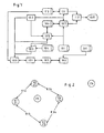
- Fig. 2 shows by way of example an internal digital map 101 in the vehicle with the nodes K1 to K4 contained therein and edges K12, K13, K24 and K34. These form the area in which autonomous navigation is possible. Furthermore, six off-board referenceable nodes Z1 to Z6 are listed. For example, via appropriate software, such as look-up tables, the nodes K1 to K4 are identified as identical to Z1 to Z4. For example, after off-board calculation of a direct route from Z1 to Z2, this is detected in the vehicle internally as identical to the independently calculable route running over edge K12 from K1 to K2
- the software switch 112 switches at any point from the internal route guidance device 107 to the external route guidance device 111 and back.
- both destination guides or algorithms 107, 111 are active at the same time, are supplied with data by the locating device 102, and during the journey already passed sections of the respective route memory 106 or 110 are marked as deleted or deleted.
- Particularly advantageous here is an automatically performed change from autonomous to off-board at transfer nodes, in which the area of the internal digital map 101 is left. For example, this could occur in the following case.
- a route from K1 or Z1 to Z6 is planned.
- a corresponding route in the autonomous system can not be planned or calculated because Z6 is not included in the internal digital map 101.
- Off-board would calculate the route Z1>Z2>Z4> Z6. By evaluating similarities, this route is analyzed. Since Z1 and Z4 can be assigned to the map nodes K1 and K4, internally an internal route share K1>K2> K4 is calculated and stored in the autonomous route memory 106.
- the software switch 112 is further provided with a rule such that, upon receipt of off-board calculated route shares, these route portions lying on the internal digital map 101 are recognized and autonomous route shares are calculated for this purpose. If both methods are then possible on a section of the route, the autonomous method is advantageously used in an advantageous manner.
- the use of the internally calculated route share allows more precise driving instructions by means of map-based locating.
- the behavior for returning to the planned route in this case is more comfortable because of the knowledge of the road network of the internal digital map 101. This is relevant in the case of intentional or unintentional departure from the planned route. If it is detected that there is no longer a possibility for autonomous route guidance, then the switch 112 switches over to the off-board route.
- an associated network transition node is stored for each destination present in the destination input memory 104 and not contained in the internal digital map 101. For example, if Z6 is input at the destination input, then K4 is found to be the associated transition point because it is stored in the destination input memory 104 as such. The route from K1 to K4 is then calculated autonomously and the route from Z4 to Z6 is requested for an off-board calculation.
- Fig. 3 shows a corresponding sequence. In the Fig.
- 3 to 5 10 denotes the vehicle-side navigation system, 12 a message transmitted via the data communication device 109, and 14 the off-board navigation system.
- the memory content of the destination input memory 104 is used to locate K4 as the local transfer node to Z6.
- a route from Z4 to Z6 is requested.
- the route Z4> Z6 is calculated in the off-board navigation system 14.
- the route Z4> Z6 is transmitted from the off-board navigation system 14 to the navigation system 10 in the vehicle.
- the internal route share K1> K4 is calculated and at 26 the route guidance starts.
- the necessary handover nodes are negotiated using a data protocol between hybrid navigation system 10 and off-board navigation system 14 based on geographical descriptions of nodes located outside the digital map, as in FIG Fig. 4 shown.
- the assignment of the transfer node K4 to the destination Z6 is not stored in the destination input memory 104. That's how it gets Fig. 4 can be seen, after entering the destination Z6 via remote data transmission 28, the destination at 30 identified in the off-board navigation system 14 and the approximate location of the target Z6 transmitted to the vehicle at 32 back and then there with the aid of a corresponding allocation algorithm at 34 the nearest transfer node K4 assigned.
- Fig. 5 1 illustrates, for identification of the transfer node in the route calculation request 18, to introduce control information with a possibility of identifying the version of the internal digital map 101.
- This information is then used off-board to identify the necessary transition nodes at 36.
- the request 18 is for a route from Z1 to Z6 with digital card V1.
- the route Z4 to Z6 is then transmitted by the off-board navigation system 14 to the internal navigation system 10 and informed that an internal route calculation has to be made by K4. This is done in 24 and in 26 the route guidance starts again.
- control information also exists from a list of possible transition points generated in the hybrid navigation system 10.
- the off-board navigation system 14 selects the transfer node to be used.
- Z5 is transmitted as a destination to the off-board navigation system 14.
- the position of Z5 is detected and then transmitted to the internal navigation system 10.
- the nodes K2 and K3 are identified as possible transfer nodes and transmitted to the off-board navigation system 14 in the subsequent communication step.
- the route Z2 is calculated to Z5 and then transmitted together with the transfer node K2 to the internal navigation system 10. This then states that an internal route share from K1 to K2 has to be calculated.
- the coding of the transfer nodes consists, for example, of geocodes according to GATS, TMC locations according to prENV 12313-3 or ERTICO ILOCs.
- the route memories 106 and 110 are combined into a single one.
- the implementation of a hybrid system according to the invention is described below using the example of a navigation system with dynamic APS (dynAPS).
- the destination is entered there either by an input device, the goals in the order "city”, possibly “district”, “street name”, “intersection or
- the possible destinations are thereby extracted from a destination input memory 104 on the CD-ROM with the internal digital map 101.
- a destination input memory 104 on the CD-ROM with the internal digital map 101.
- this destination input memory 104 is extended by additional information, cf. Fig. 4 , For the entry Paris (France), lists of possible transition nodes and rules for their selection are stored in the destination input memory 104 of the CD-ROM. For example, in the case of a Germany CD-ROM, the transfer node "A44 Aachen-Lichtenbusch" is selected for a vehicle position "North Rhine-Westphalia". This happens without the driver being able to recognize this. After entering the destination, for example, the driver has selected the "Telematics / Hybrid Route" function in the navigation settings.
- the distance to the next driving maneuver is displayed on a screen.
- a pictogram of the location of this maneuver appears with the entered expected route. This would be approaching the motorway junction Aachen on the A4 coming from Cologne only the distance to the motorway junction Aachen and when approaching a picture which "right drive out" signaled.
- the driving instructions are also spoken on approach.
- the hybrid APS When requesting a route via SMS, the hybrid APS also sends an ID to the GATS control center in addition to the start position and desired destination using the inserted CD-ROM (data scope, version), cf. Fig. 5 , It can now be recognized in the GATS central to which transition node the internal digital map 101 is to be routed.
- the invention relates to a navigation system for route guidance in a vehicle wherein the route stored for a navigation system in the navigation system proportionally from in the vehicle with data of a digital map 101 (autonomously) calculated and obtained from an external routing 302 (off-board) calculated route sections together is set.
- the externally determined portions need not necessarily be included in the digital map 101 used in the vehicle for routing.
- a further advantage is a design such that the switching between the centrally or autonomously calculated sections is either controlled by a user or unnoticed unnoticed in the background, which are provided for automatic switching in the background in the route memory, the individual route sections with control information, which control the switching ,
- a uniform user interface is used to output driving instructions and the route, regardless of which type of route section is currently being passed by the vehicle.
- the double design of the route memory 106, 110 is advantageous, with one route memory 110 containing the centrally externally calculated route and the other route memory 106 including the autonomously internally calculated route and, on the basis of control information, switching from one to the other route memory as required.
- the transmission of externally determined shares via a remote data transmission device 109, for example by data radio in a mobile network, such as the SMS transmission in the GSM. In this case, the transmission can be directed unilaterally into the vehicle (broadcast) or use bidirectional data traffic.
- the externally calculated fractions can be transferred to GATS Appendix 5.3.1 and 5.3.2, using GATS Geocodes, using TMC locations, using ERTICO IL0Cs or other methods.
- the externally calculated route is also fed via a serial line or infrared interface, a network interface or by using an externally described and read in the navigation system disk (floppy disk, PCMCIA card, ).
- the automatic generation of the control information is such that upon receipt of an externally determined route, the portions of the route, which are clearly assignable to the in-vehicle digital map, are replaced after receipt by calculated in the vehicle shares.
- the transmission of information about the in-vehicle digital map 101 to use this version information in the external route calculation to externally determine only the non-computable in the vehicle portions of the route and to transfer into the vehicle while the remaining shares calculated in the vehicle become.
- a query is automatically or manually generated to calculate an external route calculation, and the result of this calculation is then used to return to the digitized road network 101 or to route to the destination. If a route guidance with the help of the digital map 101 is possible, then advantageously switched by the route guidance using an external route to the autonomously calculated route guidance. If a route guidance with the aid of the digital map 101 is no longer possible and the vehicle position can be assigned to the route obtained externally, then switching from the autonomous route guidance to the external route is advantageously effected
Claims (13)
- Procédé de navigation d'un lieu de départ ou momentané vers un lieu de destination, un algorithme de calcul d'itinéraire d'un système de navigation (100) pour un moyen de déplacement calculant un itinéraire entre le lieu de départ ou momentané vers le lieu de destination par le biais de points nodaux enregistrés dans une carte numérique, avec lequel, dans le cas où au moins l'un des points nodaux de l'itinéraire à calculer n'est pas inclus dans une carte numérique (101) interne mémorisée à l'intérieur du système de navigation, la partie correspondante de l'itinéraire qui comprend exclusivement des points nodaux de la carte numérique interne est alors calculée sous la forme d'une partie d'itinéraire calculée en interne (106) par un algorithme de calcul d'itinéraire interne (105) en se basant sur la carte numérique interne et la partie correspondante de l'itinéraire qui ne comprend pas de points nodaux de la carte numérique interne est calculée sous la forme d'une partie d'itinéraire calculée en externe (110) par un algorithme de calcul d'itinéraire externe (302) en se basant sur une carte numérique enregistrée en externe (301) par rapport au système de navigation, les points nodaux de transition entre les itinéraires calculés en interne et en externe étant déterminés,
caractérisé en ce que
soit un algorithme interne de guidage vers la destination (107) du système de navigation effectue un guidage vers la destination en se basant sur la partie d'itinéraire calculée en interne (106), soit un algorithme externe de guidage vers la destination (111) effectue un guidage vers la destination en se basant sur la partie d'itinéraire calculée en externe (110), suivant que le moyen de déplacement se trouve à l'intérieur ou à l'extérieur de la zone de la carte numérique interne (101). - Procédé selon la revendication 1, caractérisé en ce que l'itinéraire complet est tout d'abord calculé par l'algorithme de calcul d'itinéraire externe, transmis au système de navigation, puis la partie de l'itinéraire qui comprend exclusivement des points nodaux mémorisés sur la carte numérique interne est ensuite calculée par l'algorithme de calcul d'itinéraire interne et la partie correspondante de l'itinéraire calculé en externe est remplacée par la partie d'itinéraire calculée en interne.
- Procédé selon la revendication 1, caractérisé en ce que l'algorithme de calcul d'itinéraire interne génère tout d'abord l'itinéraire calculé en interne, transmet des informations sur les parties encore manquantes de l'itinéraire, notamment les points nodaux encore manquants et les points nodaux de transitions, à l'algorithme de calcul d'itinéraire externe, l'algorithme de calcul d'itinéraire externe calcule uniquement les parties d'itinéraire encore manquantes et les transmet au système de navigation.
- Procédé selon l'une des revendications 1 à 3, caractérisé en ce que la partie d'itinéraire calculée en interne est enregistrée dans le système de navigation dans une mémoire d'itinéraire interne et la partie d'itinéraire calculée en externe est enregistrée dans une mémoire d'itinéraire externe.
- Procédé selon la revendication 4, caractérisé en ce que lorsqu'un point nodal de transition est atteint, une permutation est effectuée de l'algorithme interne de guidage vers la destination sur l'algorithme externe de guidage vers la destination lorsque le moyen de déplacement quitte la zone de la carte numérique interne et une permutation est effectuée de l'algorithme externe de guidage vers la destination sur l'algorithme interne de guidage vers la destination lorsque le moyen de déplacement atteint la zone de la carte numérique interne.
- Procédé selon l'une des revendications 1 à 4, caractérisé en ce que pendant le guidage vers la destination, les points nodaux déjà atteints ou les sections franchies de l'itinéraire sont marquées comme accomplies ou franchies ou encore effacées à la fois dans la mémoire d'itinéraire interne et dans la mémoire d'itinéraire externe, et ce indépendamment de l'algorithme de guidage vers l'itinéraire qui est momentanément actif.
- Procédé selon l'une des revendications précédentes, caractérisé en ce que dans une mémoire de saisie de destination du système de navigation sont enregistrés à la fois les points nodaux internes enregistrés dans la carte numérique interne et les points nodaux externes qui se trouvent en dehors de la zone de la carte numérique interne, au moins un point nodal de transition étant enregistré pour prédéfinir les points nodaux externes, le point nodal de transition étant un point nodal interne contenu dans la carte numérique interne.
- Procédé selon l'une des revendications précédentes, caractérisé en ce que les points nodaux de transition nécessaires sont déterminés au moyen d'un relevé de données à l'aide de descriptions géographiques des points nodaux qui se trouvent à l'extérieur de la carte numérique interne dans une étape de communication particulière entre le système de navigation et un système de navigation hors véhicule, lequel exécute l'algorithme de calcul d'itinéraire externe et mémorise la carte numérique externe.
- Procédé selon l'une des revendications précédentes, caractérisé en ce qu'après avoir saisi un lieu de destination qui se trouve en dehors de la zone de la carte numérique interne, le système de navigation transmet à un système de navigation hors véhicule, lequel exécute l'algorithme de calcul d'itinéraire externe et mémorise la carte numérique externe, le lieu de destination saisi ainsi qu'un numéro de version de la carte numérique interne, le système de navigation hors véhicule déterminant à partir de ces informations un point nodal de transition à partir duquel la partie d'itinéraire externe vers le lieu de destination saisi est calculée par l'algorithme de calcul d'itinéraire externe puis transmise au système de navigation.
- Procédé selon l'une des revendications précédentes, caractérisé en ce que le système de navigation transmet à un système de navigation hors véhicule, lequel exécute l'algorithme de calcul d'itinéraire externe et mémorise la carte numérique externe, une liste des points nodaux de transition possibles, le système de navigation hors véhicule sélectionnant au moins un point nodal de transition approprié conformément à la partie d'itinéraire calculée en externe et le transmet au système de navigation conjointement avec la partie d'itinéraire calculée en externe.
- Procédé selon l'une des revendications précédentes, caractérisé en ce que le calcul de la partie d'itinéraire calculée en externe est réalisé lorsque le moyen de déplacement quitte une zone de la carte numérique interne.
- Système de navigation (100) pour un moyen de déplacement, notamment un véhicule automobile, un navire ou un aéronef, comprenant une mémoire d'itinéraire interne (106), un dispositif interne de guidage vers la destination (107) relié à celle-ci, une carte numérique interne (101) et un dispositif de communication de données (109) pour communiquer avec un système de navigation externe hors véhicule (301 à 303),
caractérisé en ce
qu'il est prévu une mémoire d'itinéraire externe (110) reliée avec le dispositif de communication de données ainsi qu'un dispositif externe de guidage vers la destination (111) relié avec celui-ci, un dispositif de commutation (112) étant également prévu qui, pendant un guidage vers la destination, active au choix le dispositif externe de guidage vers la destination (111) ou le dispositif interne de guidage vers la destination (107) suivant que le moyen de déplacement se trouve à l'intérieur ou à l'extérieur de la zone de la carte numérique interne (101). - Système de navigation (100) selon la revendication 12, caractérisé en ce que la mémoire d'itinéraire interne (106) et la mémoire d'itinéraire externe (110) sont regroupées en une seule mémoire.
Applications Claiming Priority (3)
| Application Number | Priority Date | Filing Date | Title |
|---|---|---|---|
| DE19859080 | 1919-12-21 | ||
| DE19859080A DE19859080C5 (de) | 1998-12-21 | 1998-12-21 | Navigationsverfahren und Navigationssystem für Fortbewegungsmittel |
| PCT/DE1999/003962 WO2000038130A1 (fr) | 1998-12-21 | 1999-12-11 | Procede et dispositif de navigation pour moyens de deplacement |
Publications (3)
| Publication Number | Publication Date |
|---|---|
| EP1141910A1 EP1141910A1 (fr) | 2001-10-10 |
| EP1141910B1 EP1141910B1 (fr) | 2003-04-16 |
| EP1141910B2 true EP1141910B2 (fr) | 2009-08-05 |
Family
ID=7892004
Family Applications (1)
| Application Number | Title | Priority Date | Filing Date |
|---|---|---|---|
| EP99964431A Expired - Lifetime EP1141910B2 (fr) | 1998-12-21 | 1999-12-11 | Procede et dispositif de navigation pour moyens de deplacement |
Country Status (5)
| Country | Link |
|---|---|
| US (1) | US6456933B1 (fr) |
| EP (1) | EP1141910B2 (fr) |
| JP (1) | JP4280424B2 (fr) |
| DE (2) | DE19859080C5 (fr) |
| WO (1) | WO2000038130A1 (fr) |
Families Citing this family (24)
| Publication number | Priority date | Publication date | Assignee | Title |
|---|---|---|---|---|
| DE10120370A1 (de) * | 2001-04-25 | 2002-11-07 | Becker Flugfunkwerk Gmbh | Verfahren und Anordnung zur Zustellung von luftfahrtrelevanten Daten an Datenbanken |
| US7146273B2 (en) * | 2002-02-07 | 2006-12-05 | Sanyo Electric Co., Ltd. | Navigation system, navigation apparatus, and server apparatus |
| DE10223816B4 (de) * | 2002-05-28 | 2005-07-14 | Flakowski, Wolfgang | Verfahren und Vorrichtung zur Navigation und Information von Benutzen |
| EP1387145A1 (fr) * | 2002-08-02 | 2004-02-04 | ComRoad AG | Système de navigation differentielle et dynamique pour navigation de véhicule hors-bord |
| US7133771B1 (en) * | 2002-08-29 | 2006-11-07 | America Online, Inc. | Automated route determination to avoid a particular maneuver |
| US8560223B2 (en) | 2002-08-29 | 2013-10-15 | Mapquest, Inc. | Automated route determination |
| US7321824B1 (en) | 2002-12-30 | 2008-01-22 | Aol Llc | Presenting a travel route using more than one presentation style |
| US7818116B1 (en) | 2002-12-30 | 2010-10-19 | Mapquest, Inc. | Presenting a travel route in a ground-based vehicle |
| US7474960B1 (en) | 2002-12-30 | 2009-01-06 | Mapquest, Inc. | Presenting a travel route |
| RU2007104707A (ru) | 2004-07-09 | 2008-08-20 | Аол Ллк (Us) | Устранение неоднозначности неоднозначных символов |
| DE102004039465A1 (de) * | 2004-08-14 | 2006-02-23 | Robert Bosch Gmbh | Verfahren zur Navigation |
| JP4529604B2 (ja) * | 2004-09-15 | 2010-08-25 | パナソニック株式会社 | 経路誘導装置 |
| US8606500B2 (en) * | 2006-05-26 | 2013-12-10 | General Motors Llc | Method and device for demonstrating features of a vehicle navigation system |
| US8606506B2 (en) * | 2006-07-26 | 2013-12-10 | General Motors Llc | Route-matching method for use with vehicle navigation systems |
| US7865303B2 (en) * | 2006-11-09 | 2011-01-04 | General Motors Llc | Method of providing a navigational route for a vehicle navigation system |
| JP4307498B2 (ja) * | 2007-07-10 | 2009-08-05 | 本田技研工業株式会社 | ナビ装置、ナビシステム |
| WO2009077679A2 (fr) * | 2007-10-03 | 2009-06-25 | Webraska Mobile Technologies | Terminal de navigation et de localisation et système de navigation et de localisation comprenant un tel terminal |
| US8725407B2 (en) | 2009-11-09 | 2014-05-13 | United Parcel Service Of America, Inc. | Enhanced location information for points of interest |
| CN104598979B (zh) * | 2013-10-31 | 2021-10-08 | Sap欧洲公司 | 基于时间和位置的递送最优化 |
| CN109071014B (zh) | 2016-04-29 | 2022-07-22 | 美国联合包裹服务公司 | 无人机拾取及递送系统 |
| US10730626B2 (en) | 2016-04-29 | 2020-08-04 | United Parcel Service Of America, Inc. | Methods of photo matching and photo confirmation for parcel pickup and delivery |
| US10775792B2 (en) | 2017-06-13 | 2020-09-15 | United Parcel Service Of America, Inc. | Autonomously delivering items to corresponding delivery locations proximate a delivery route |
| US11598639B2 (en) * | 2019-05-20 | 2023-03-07 | Schlumberger Technology Corporation | System for offsite navigation |
| DE102020101445A1 (de) | 2020-01-22 | 2021-07-22 | Bayerische Motoren Werke Aktiengesellschaft | Bestimmen einer Route auf einer Karte |
Citations (2)
| Publication number | Priority date | Publication date | Assignee | Title |
|---|---|---|---|---|
| DE19623666C1 (de) † | 1996-06-13 | 1997-11-20 | Siemens Ag | Verfahren zur dynamischen Routenempfehlung |
| WO2000022593A1 (fr) † | 1998-10-14 | 2000-04-20 | Siemens Automotive Corporation | Systeme d'information pour conducteurs |
Family Cites Families (9)
| Publication number | Priority date | Publication date | Assignee | Title |
|---|---|---|---|---|
| JP2868393B2 (ja) * | 1993-07-27 | 1999-03-10 | アイシン・エィ・ダブリュ株式会社 | ナビゲーション装置 |
| DE19516964A1 (de) * | 1995-05-12 | 1996-11-14 | Sel Alcatel Ag | System zur individuellen, fahrzeugautonomen Zielführung für Straßenfahrzeuge |
| DE19539641C2 (de) * | 1995-10-25 | 2000-02-17 | Daimler Chrysler Ag | Verfahren und Einrichtung zur verkehrssituationsabhängigen Fahrzeugzielführung |
| KR970002795A (ko) * | 1995-10-30 | 1997-01-28 | 모리 하루오 | 네비게이션(navigation)장치 |
| JP3413318B2 (ja) * | 1995-12-25 | 2003-06-03 | トヨタ自動車株式会社 | 経路情報提供方法及び経路情報提供システム |
| DE19636379C1 (de) * | 1996-09-09 | 1998-03-12 | Intertraffic Ges Fuer Integrie | Verfahren zur Steuerung des Transport- und Reiseverkehrs |
| DE19750777B4 (de) * | 1996-12-16 | 2004-04-22 | Atx Europe Gmbh | Verfahren zur Übertragung von einer Route eines Fahrzeuges in einem Verkehrsnetz betreffenden Routeninformationen zwischen einer Verkehrszentrale und einem Endgerät in einem Fahrzeug, eine Verkehrszentrale und ein Endgerät |
| JP3603927B2 (ja) * | 1997-08-08 | 2004-12-22 | アイシン・エィ・ダブリュ株式会社 | 車両用ナビゲーション装置及びナビゲーション方法 |
| JP4117971B2 (ja) * | 1999-04-30 | 2008-07-16 | 本田技研工業株式会社 | 移動体用地図情報表示システム |
-
1998
- 1998-12-21 DE DE19859080A patent/DE19859080C5/de not_active Expired - Fee Related
-
1999
- 1999-12-11 EP EP99964431A patent/EP1141910B2/fr not_active Expired - Lifetime
- 1999-12-11 WO PCT/DE1999/003962 patent/WO2000038130A1/fr active IP Right Grant
- 1999-12-11 US US09/868,830 patent/US6456933B1/en not_active Expired - Lifetime
- 1999-12-11 JP JP2000590119A patent/JP4280424B2/ja not_active Expired - Fee Related
- 1999-12-11 DE DE59905112T patent/DE59905112D1/de not_active Expired - Lifetime
Patent Citations (2)
| Publication number | Priority date | Publication date | Assignee | Title |
|---|---|---|---|---|
| DE19623666C1 (de) † | 1996-06-13 | 1997-11-20 | Siemens Ag | Verfahren zur dynamischen Routenempfehlung |
| WO2000022593A1 (fr) † | 1998-10-14 | 2000-04-20 | Siemens Automotive Corporation | Systeme d'information pour conducteurs |
Also Published As
| Publication number | Publication date |
|---|---|
| EP1141910B1 (fr) | 2003-04-16 |
| JP4280424B2 (ja) | 2009-06-17 |
| WO2000038130A1 (fr) | 2000-06-29 |
| EP1141910A1 (fr) | 2001-10-10 |
| DE19859080C1 (de) | 2000-08-31 |
| DE19859080C5 (de) | 2005-09-22 |
| US6456933B1 (en) | 2002-09-24 |
| DE59905112D1 (de) | 2003-05-22 |
| JP2002533688A (ja) | 2002-10-08 |
Similar Documents
| Publication | Publication Date | Title |
|---|---|---|
| EP1141910B2 (fr) | Procede et dispositif de navigation pour moyens de deplacement | |
| EP0899704B1 (fr) | Procédé de commande et de navigation pour automobile | |
| DE4226230C2 (de) | Vorrichtung zur Navigation von Motorfahrzeugen | |
| EP1497618B1 (fr) | Procede et systeme de guidage dynamique d'un vehicule | |
| DE19912859B4 (de) | Kommunikationsfähiges Navigationssystem | |
| DE19703436B4 (de) | Fahrzeuggebundene Wegesuchvorrichtung und Wegesuchverfahren | |
| DE69730463T2 (de) | Verfahren und Vorrichtung zum Eingeben von Routen in einem Navigationssystem | |
| DE4301875C2 (de) | Verkehrsnavigationseinrichtung mit einer Nebenstreckenfunktion | |
| EP1485897B1 (fr) | Procede et systeme de guidage automatique de vehicule | |
| DE10013675B4 (de) | Fahrzeug-Navigationssystem | |
| EP1297310B1 (fr) | Procede de selection d'informations a partir d'une carte, et dispositif de navigation | |
| DE4339059C2 (de) | Navigationsvorrichtung und Verfahren zum Navigieren | |
| DE102005046177A1 (de) | Fahrzeugnavigationssystem | |
| DE602004006821T2 (de) | Steuerungsvorrichtung zur Führung eines Fahrzeuges | |
| EP1204957A1 (fr) | Procede de navigation pour un moyen de transport | |
| WO1997018544A2 (fr) | Procede et unite pour le guidage fiable d'un vehicule | |
| DE102014008151A1 (de) | Verfahren zum Betrieb eines Kraftfahrzeugs | |
| DE4405771A1 (de) | Navigationssystem mit einem Routenbestimmungsverfahren zum schnellen und genauen Bestimmen einer gewünschten Route | |
| EP0944894B1 (fr) | Procede de navigation assistee par ordinateur d'un vehicule equipe d'un terminal, terminal et central d'informations routieres | |
| WO1999046562A1 (fr) | Procede d'affichage d'informations de trafic | |
| DE102009047410A1 (de) | Verfahren und Navigationsgerät zum dynamischen Ermitteln eines Routenverlaufs | |
| DE19616071A1 (de) | Verfahren und Einrichtung zur Zielführung eines Fahrzeuges | |
| EP1779067B1 (fr) | Procede de navigation | |
| DE10253135A1 (de) | Verfahren und Vorrichtung zur Aufbereitung von Verkehrsinformationen | |
| DE19753172A1 (de) | Verfahren zur rechnergestützten Navigation eines Fahrzeuges mit einem Endgerät, Endgerät und Verkehrszentrale |
Legal Events
| Date | Code | Title | Description |
|---|---|---|---|
| PUAI | Public reference made under article 153(3) epc to a published international application that has entered the european phase |
Free format text: ORIGINAL CODE: 0009012 |
|
| 17P | Request for examination filed |
Effective date: 20010723 |
|
| AK | Designated contracting states |
Kind code of ref document: A1 Designated state(s): AT BE CH CY DE DK ES FI FR GB GR IE IT LI LU MC NL PT SE |
|
| GRAG | Despatch of communication of intention to grant |
Free format text: ORIGINAL CODE: EPIDOS AGRA |
|
| 17Q | First examination report despatched |
Effective date: 20020125 |
|
| GRAG | Despatch of communication of intention to grant |
Free format text: ORIGINAL CODE: EPIDOS AGRA |
|
| GRAH | Despatch of communication of intention to grant a patent |
Free format text: ORIGINAL CODE: EPIDOS IGRA |
|
| GRAH | Despatch of communication of intention to grant a patent |
Free format text: ORIGINAL CODE: EPIDOS IGRA |
|
| GRAA | (expected) grant |
Free format text: ORIGINAL CODE: 0009210 |
|
| AK | Designated contracting states |
Designated state(s): DE FR GB IT |
|
| REG | Reference to a national code |
Ref country code: GB Ref legal event code: FG4D Free format text: NOT ENGLISH |
|
| REF | Corresponds to: |
Ref document number: 59905112 Country of ref document: DE Date of ref document: 20030522 Kind code of ref document: P |
|
| REG | Reference to a national code |
Ref country code: IE Ref legal event code: FG4D Free format text: GERMAN |
|
| GBT | Gb: translation of ep patent filed (gb section 77(6)(a)/1977) | ||
| PLBI | Opposition filed |
Free format text: ORIGINAL CODE: 0009260 |
|
| REG | Reference to a national code |
Ref country code: IE Ref legal event code: FD4D Ref document number: 1141910E Country of ref document: IE |
|
| ET | Fr: translation filed | ||
| 26 | Opposition filed |
Opponent name: DAIMLERCHRYSLER AG Effective date: 20031030 |
|
| PLAX | Notice of opposition and request to file observation + time limit sent |
Free format text: ORIGINAL CODE: EPIDOSNOBS2 |
|
| PLAX | Notice of opposition and request to file observation + time limit sent |
Free format text: ORIGINAL CODE: EPIDOSNOBS2 |
|
| PLBB | Reply of patent proprietor to notice(s) of opposition received |
Free format text: ORIGINAL CODE: EPIDOSNOBS3 |
|
| PLAB | Opposition data, opponent's data or that of the opponent's representative modified |
Free format text: ORIGINAL CODE: 0009299OPPO |
|
| R26 | Opposition filed (corrected) |
Opponent name: DAIMLERCHRYSLER AG Effective date: 20031030 |
|
| PLAB | Opposition data, opponent's data or that of the opponent's representative modified |
Free format text: ORIGINAL CODE: 0009299OPPO |
|
| R26 | Opposition filed (corrected) |
Opponent name: DAIMLER AG Effective date: 20031030 |
|
| PUAH | Patent maintained in amended form |
Free format text: ORIGINAL CODE: 0009272 |
|
| STAA | Information on the status of an ep patent application or granted ep patent |
Free format text: STATUS: PATENT MAINTAINED AS AMENDED |
|
| 27A | Patent maintained in amended form |
Effective date: 20090805 |
|
| AK | Designated contracting states |
Kind code of ref document: B2 Designated state(s): DE FR GB IT |
|
| PGFP | Annual fee paid to national office [announced via postgrant information from national office to epo] |
Ref country code: IT Payment date: 20091223 Year of fee payment: 11 Ref country code: GB Payment date: 20091221 Year of fee payment: 11 |
|
| GBPC | Gb: european patent ceased through non-payment of renewal fee |
Effective date: 20101211 |
|
| PG25 | Lapsed in a contracting state [announced via postgrant information from national office to epo] |
Ref country code: GB Free format text: LAPSE BECAUSE OF NON-PAYMENT OF DUE FEES Effective date: 20101211 |
|
| PG25 | Lapsed in a contracting state [announced via postgrant information from national office to epo] |
Ref country code: IT Free format text: LAPSE BECAUSE OF NON-PAYMENT OF DUE FEES Effective date: 20101211 |
|
| PGFP | Annual fee paid to national office [announced via postgrant information from national office to epo] |
Ref country code: FR Payment date: 20141212 Year of fee payment: 16 |
|
| PGFP | Annual fee paid to national office [announced via postgrant information from national office to epo] |
Ref country code: DE Payment date: 20160224 Year of fee payment: 17 |
|
| REG | Reference to a national code |
Ref country code: FR Ref legal event code: ST Effective date: 20160831 |
|
| PG25 | Lapsed in a contracting state [announced via postgrant information from national office to epo] |
Ref country code: FR Free format text: LAPSE BECAUSE OF NON-PAYMENT OF DUE FEES Effective date: 20151231 |
|
| REG | Reference to a national code |
Ref country code: DE Ref legal event code: R119 Ref document number: 59905112 Country of ref document: DE |
|
| PG25 | Lapsed in a contracting state [announced via postgrant information from national office to epo] |
Ref country code: DE Free format text: LAPSE BECAUSE OF NON-PAYMENT OF DUE FEES Effective date: 20170701 |