EP0762360B1 - Navigation system for vehicles - Google Patents
Navigation system for vehicles Download PDFInfo
- Publication number
- EP0762360B1 EP0762360B1 EP96113329A EP96113329A EP0762360B1 EP 0762360 B1 EP0762360 B1 EP 0762360B1 EP 96113329 A EP96113329 A EP 96113329A EP 96113329 A EP96113329 A EP 96113329A EP 0762360 B1 EP0762360 B1 EP 0762360B1
- Authority
- EP
- European Patent Office
- Prior art keywords
- guidance
- route
- information
- guide branch
- branch point
- Prior art date
- Legal status (The legal status is an assumption and is not a legal conclusion. Google has not performed a legal analysis and makes no representation as to the accuracy of the status listed.)
- Expired - Lifetime
Links
- 238000012545 processing Methods 0.000 description 25
- 238000007514 turning Methods 0.000 description 4
- 102100032341 PCNA-interacting partner Human genes 0.000 description 1
- 101710196737 PCNA-interacting partner Proteins 0.000 description 1
- 230000001413 cellular effect Effects 0.000 description 1
- 230000003247 decreasing effect Effects 0.000 description 1
- 230000006870 function Effects 0.000 description 1
- 239000004973 liquid crystal related substance Substances 0.000 description 1
- 230000002194 synthesizing effect Effects 0.000 description 1
Images


Classifications
-
- G—PHYSICS
- G01—MEASURING; TESTING
- G01C—MEASURING DISTANCES, LEVELS OR BEARINGS; SURVEYING; NAVIGATION; GYROSCOPIC INSTRUMENTS; PHOTOGRAMMETRY OR VIDEOGRAMMETRY
- G01C21/00—Navigation; Navigational instruments not provided for in groups G01C1/00 - G01C19/00
- G01C21/26—Navigation; Navigational instruments not provided for in groups G01C1/00 - G01C19/00 specially adapted for navigation in a road network
- G01C21/34—Route searching; Route guidance
- G01C21/36—Input/output arrangements for on-board computers
- G01C21/3626—Details of the output of route guidance instructions
- G01C21/3632—Guidance using simplified or iconic instructions, e.g. using arrows
-
- G—PHYSICS
- G08—SIGNALLING
- G08G—TRAFFIC CONTROL SYSTEMS
- G08G1/00—Traffic control systems for road vehicles
- G08G1/09—Arrangements for giving variable traffic instructions
- G08G1/0962—Arrangements for giving variable traffic instructions having an indicator mounted inside the vehicle, e.g. giving voice messages
- G08G1/0968—Systems involving transmission of navigation instructions to the vehicle
- G08G1/0969—Systems involving transmission of navigation instructions to the vehicle having a display in the form of a map
Definitions
- the present invention relates to a navigation system for vehicles, in which marks such as arrows are displayed to indicate advancing direction at guide branch points on a suggested route or an arrow to indicate advancing direction at a guide branch point (hereinafter referred as "guide branch point").
- a navigation system for vehicles mounted on an automobile and used for providing guidance for a route is known in the past, in which data of places such destination, transit points, etc. are inputted to search a route from the present position or a starting point of a vehicle, and the searched route is displayed on a map or an arrow to indicate advancing direction is displayed on an enlarged view.
- Fig. 1 shows a route leading to a destination * (park) through a highway indicated by white line (or outlined line) displayed on a map.
- Fig. 2 is an enlarged view of the vicinity of a guide branch point of a route leading from PARI to Airport, where an arrow indicating the advancing direction at a guide branch point and a sign "5.0 miles or 10 minutes to the destination" are displayed.
- the route is drawn on the map as shown in Fig. 1.
- the driver must judge a turning point and a turning direction by watching this map, and it often takes considerable time to have full understanding of the situation.
- the map is enlarged as shown in Fig. 2, the next guide branch point is out of the area displayed on the screen, and this causes inconvenience for the driver because it is not possible to find out the turning direction on the route ahead of the guide branch point.
- Novel Route Guidance Displays discloses a route guidance system where the system visually communicates to a driver how to proceed through a succession of intersections. As shown in Fig. 1, when a vehicle passes through intersections located one after another, advancing direction guidance information of each intersection is sequentially displayed from bottom to top of the display by perspective projections, and each street can be visually identified by a gap and horizontal bar.
- the navigation system for vehicles comprises a guidance control means for displaying guidance information on advancing directions at a first guide branch point by overlapping it on guidance information on advancing direction at a second guide branch point. Further, there is provided a judging means for judging whether a distance between a branch point where guidance is needed next and the next guide branch point is within a given value, and only when it is judged that the distance between the guide branch points is within a given value, guidance information for advancing direction at the next guide branch point is displayed. Also, the guidance control means displays guidance information on advancing direction at a first guide branch point and also displays the guidance on advancing directions to the destination on top of the others, i.e. the information at the nearer guide branch point displayed on upper layer.
- Fig. 3 represents an example of an arrangement of a navigation system according to the present invention.
- the navigation system according to the present invention comprises, as shown in Fig. 3, an input/output unit 1 for inputting and outputting information relating to route guidance, a present position detecting unit 2 for detecting information relating to the present position of the vehicle, an information storage unit 3 for storing navigation data necessary for calculating an optimal route or display guidance data necessary for guidance, and a central processing unit 4 for route search processing and display guidance processing necessary for route guidance and for controlling the entire system.
- the input/output unit 1 instructs navigation processing to the central processing unit 4 to input destination data at the intention of the driver so that guidance information can be outputted in voice and/or on screen when the driver needs such information and to print out the data after the processing.
- the input unit comprises a touch switch 11 or an operation switch to input the destination using telephone number or coordinates on map or to request route guidance.
- the output unit comprises a display unit 12 for displaying the inputted data on screen or for displaying route guidance automatically on screen at the request of the driver, a printer 13 for printing out the data processed by the central processing unit 4 or the data stored in the information storage unit 3, and a speaker 16 for outputting the route guidance information by voice.
- a voice recognizing device for outputting in voice or a card reader for reading data recorded on IC card or magnetic card.
- a data communication device which stores data necessary for navigation and exchanges data to and from an information center where data necessary for navigation is stored and is offered via communication line at the request of the driver or to and from an information source such as electronic notebook where data specific to the driver such as map data, destination data, etc. are stored in advance.
- the display unit 12 comprises a color CRT or a color liquid crystal display, and all screens necessary for navigation such as target name input screen, route setting screen, sector view screen, intersection view screen, and direction guidance screen at branch point such as intersection are outputted in color display based on map data and guidance data processed by the central processing unit 4, and buttons are displayed on the screen for setting the route guidance or for switching over guidance or screen during route guidance.
- transit intersection information such as names of transit intersections is given in pop art color display on the sector view screen when necessary.
- This display unit 12 is installed on an instrument panel near the driver's seat. By watching the sector view, the driver can confirm the present position of the vehicle and can obtain information on the route ahead.
- the display unit 12 is provided with a touch panel 11 to match the display of functional buttons. By touching the button, the above operation is executed based on the inputted signal.
- the input signal generating means comprising this button and the touch switch constitutes the input unit, but detailed description is not given here.
- the present position detecting unit 2 is provided with a GPS receiver 21 utilizing global positioning system (GPS), a beacon receiver 22, a data transceiver for receiving compensation signal of GPS utilizing cellular phone (automobile phone) or FM multiplex signal, an absolute heading sensor 24 comprising a geomagnetic sensor, a relative heading sensor comprising wheel sensor, steering sensor, gyro, etc. and a distance sensor for detecting traveled distance from number of revolutions of wheels.
- GPS global positioning system
- beacon receiver 22 a data transceiver for receiving compensation signal of GPS utilizing cellular phone (automobile phone) or FM multiplex signal
- an absolute heading sensor 24 comprising a geomagnetic sensor
- a relative heading sensor comprising wheel sensor, steering sensor, gyro, etc.
- a distance sensor for detecting traveled distance from number of revolutions of wheels.
- the information storage unit 3 is a data base where all necessary data for navigation system are recorded and comprises files such as map data, intersection data, node data, road data, photograph data, registered point data, guidance point data, destination data, telephone number data, address data, etc.
- the central processing unit 4 comprises a CPU 40 for executing various computation processings, a first RAM 41 for storing programs to execute processing such as route searching and programs for display output control necessary for route guidance and for audio output control necessary for audio guidance and necessary data, a RAM 42 for temporarily storing route guidance information searched such as coordinates, road surface code No., etc.
- a 2nd ROM 43 for storing display information data necessary for route guidance and map display
- an image memory 44 for storing image data used for screen display on the display unit
- an image processor 45 for picking up the image data from the image memory 44 based on the display output control signal from the CPU 40 and for outputting it to the display unit after image processing
- an audio processor 46 for synthesizing voice, phrase, a sizable sentence, sound, etc.
- a communication interface 47 for sending and receiving input/output data by communication
- a sensor input interface 48 for incorporating sensor signal of the present position detecting unit 2
- a clock 49 for recording date and time to internal dialog information.
- route guidance is carried out by screen display and audio output, and the driver can select whether the data should be provided in audio output or not.
- Fig. 4 to Fig. 6 shows an arrangement example of major data file stored in the information storage unit 3 of the present invention shown in Fig. 3.
- Fig. 4 (A) represents guidance road data file where data necessary for calculating a route by a route calculating means and for providing route guidance are stored.
- data such as road number, length, road attribute data, address and size of configuration data, and address and size of guidance data.
- the road number is set for each direction (outward course and return course) for each road between branch points.
- the road attribute data serving as auxiliary information data for road guidance are the data, as shown in Fig.
- the configuration data has, as shown in Fig. 4 (B), coordinate data comprising east longitude and north latitude of each of several meters of node when each road is divided into a plurality of nodes.
- the guidance data comprises, as shown in Fig. 4 (C), intersection (or branch point) name, precaution point data, road name data, address and size of road name audio data, and address and size of destination data.
- the precaution point data are the data indicating information such as railroad crossing, tunnel entrance, tunnel exit, road width reduced point, or no suggestion as shown in Fig. 6 (A). These are the data to warn the driver of precaution points such as railroad crossing, tunnel, etc. other than branch points.
- the road name data are, as shown in Fig. 5 (B), the data to indicate road type information such as expressway, municipal expressway, toll road, general road (national road, prefectural road, and others) and also information indicating whether expressway, municipal expressway or toll road is a main line or an approach road. It comprises road type data and in-type number, which is individual number data for each road type.
- the destination data comprises, as shown in Fig. 4 (D), destination road number, destination name, address and size of destination name audio data, destination direction data, and traveling guidance data.
- Fig. 7 is a flow chart for explaining a flow of the entire navigation system of the present invention.
- Step S1 When the program of route guidance system is started by CPU 51 of the central processing unit 4, the present position of the vehicle is detected by a present position detecting unit 2, and a map of the vicinity of the present position is displayed. Also, the name and other data of the present position are displayed (Step S1). Next, a destination is set using target name, telephone number, address, registered point, etc. of the place or the facility (Step S2), and an optimal route from the present position to the destination is searched (Step S3). When the route has been determined, the present position is traced by the present position detecting unit 2, and route guidance and display are repeatedly performed until the vehicle reaches the destination (Step S4). In the present invention, the destination direction data (Fig. (E)) of Fig.
- Step S4 guidance for two advancing directions at the adjacent guide branch points is displayed.
- displaying position of the second advancing direction guidance is changed and it is displayed according to the advancing direction at the first guide branch point.
- a search area is set, and re-searching is performed in the search area. Then, route guidance is repeatedly provided until the vehicle reaches the destination.
- Fig. 8 is a flow chart of processing to draw a sector view to display the advancing directions in the present invention
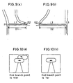
- Fig. 9 is to explain advancing direction display
- Fig. 10 represents advancing direction display screens.
- Fig. 9 (a) where there is a second guide branch point P2 at a position in near distance D1 from a first guide branch point P1 and the leading route is turned in rightward direction at the guide branch point P1 and in leftward direction at the guide branch point P2 as shown by arrow in Fig. 9 (a)
- Fig. 9 (b) where there is a second guide branch point Q2 at a position in long distance D2 from a first guide branch point Q1 and the leading route is turned in leftward direction at the guide branch point Q1 and in rightward direction at the guide branch point Q2.
- advancing direction at the first guide branch point (P1 or Q1) is acquired from the destination direction data (Fig. 4 (E)) of the destination data shown in Fig. 4 (D) as stored in the information storage unit.
- a distance (D1 or D2) from the first guide branch point to the second guide branch point is acquired.
- road type i.e. whether it is a general road or an expressway
- a display distance is determined according to road type. The display distance is, for example, 1 km in case of expressway and 300 m in case of general road, and it is a preset distance necessary for deciding whether two advancing directions should be displayed or not.
- base portion such as road is drawn and it is judged whether the distance (D1 or D2) to the second guide branch point is shorter than the display distance or not.
- the distance D1 is short as shown in Fig. 9 (a) and the guide branch point P2 is within the display distance
- advancing direction at the second guide branch point P2 is acquired from the destination direction data (Fig. 4 (E)) of the destination data shown in Fig. 4 (D) as stored in the information storage unit, and it is drawn on a given area. Partially overlapping on this area, advancing direction at the first guide branch point P1 is drawn on a given area (Fig. 10 (a)).
- the distance D2 is long as shown in Fig. 9 (b) and the guide branch point Q2 is beyond the display distance
- only the advancing direction at the first guide branch point Q1 is drawn on a given area (Fig. 10 (b)).
- the advancing direction guidance information at the first guide branch point is displayed by overlapping on the advancing direction guidance information at the second guide branch point, and it is easily recognized that the information on top of the others, i.e. on the uppermost layer, has higher priority. Accordingly, the next advancing direction guidance can be easily recognized and it is also possible to simultaneously recognize the next advancing direction guidance. Only when the branch points requiring guidance are located adjacent to each other, both the advancing direction guidance at the next guide branch point and the advancing direction guidance at the guide branch point after the next can be outputted. Therefore, the user can easily recognize that the branch points requiring guidance are adjacent to each other, and the driver can drive the vehicle at ease and with full confidence.
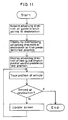
- Fig. 11 is a flow chart of processing to display advancing direction guidance
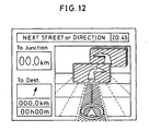
- Fig. 12 shows a screen displayed by this display processing.
- advancing directions at all guide branch points to the destination are acquired from the destination direction data (Fig. 4 (E)) of the destination data shown in Fig. 4 (D) as stored in the information storage unit, and these data are displayed at a first predetermined position by overwriting in layers with the advancing direction at the guide branch point nearest to the present position placed on the uppermost layer.
- the advancing direction overwritten on the uppermost layer is shown by a left turn mark as given at upper right of the display screen, and marks of advancing directions at the subsequent guide branch points are sequentially displayed under the top layer.
- the road is displayed at the center of the screen, and the present position is indicated by a mark of a triangle encircled by a circle.
- the advancing direction at the next guide branch point is displayed at a second predetermined position.
- a right turn arrow mark of the next guide branch point is displayed at the upper center of the screen in the example of Fig. 12, and the mark of right turn arrow for guiding the advancing direction at the next guide branch point is displayed by partially overlapping on the next mark of left turn arrow.
- the present position detecting unit the position of the vehicle is traced, and it is judged whether the vehicle reached the destination or not. Until the vehicle reaches the destination, each time it is detected that the vehicle has passed through a guide branch point, the screen is updated, and advancing direction guidance marks for the next guide branch point and the guide branch point after the next are newly displayed.
- the updating of the screen is performed, for example, as follows: the advancing direction mark at the second predetermined position as displayed so far is erased, and the advancing direction mark at the next guide branch point is newly displayed at the second predetermined position, and the advancing direction mark at the next guide branch point is displayed at the first predetermined position at the same time.
- the advancing direction marks at the guide branch points are overlapped in layers up to the destination.
- the number of the layers on the screen it is possible to find out the number of the guide branch points where the vehicle should pass through. Therefore, by counting the number of the remaining layers of the advancing direction marks, it is possible to recognize that the number of turnings ahead has decreased as the vehicle comes closer to the destination.
- the number of the advancing direction marking is turned to one, information (marking) of the destination is finally displayed, and when the vehicle arrives at the destination, the processing to display advancing direction guidance is completed. Accordingly, by finally indicating the information of the destination, it is possible to reach the destination without any further guidance information.
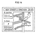
- Fig. 13 is a flow chart of processing to draw in case advancing direction arrows at the first and the second guide branch points are separately displayed, and Fig. 14 shows an intersection screen.
- Fig. 14 in case two or more guidance displays to indicate the advancing directions are given when an intersection screen is displayed, number and positions of guide branch points are acquired from the guidance road data and guidance data of Figs. 4 (A) and (C) as stored in the information storage unit, and for example, an arrow mark is drawn on the screen. This arrow mark is drawn along the leading route and on it. If there are two or more guide branch points in the arrow mark thus drawn, the advancing direction guidance information is divided and is drawn separately. Specifically, ccordinates of the middle point between the guide branch points is obtained, and heading is acquired from the destination direction data (Fig. 4 (E)) of the destination data shown in Fig. 4 (D), and the arrow mark is drawn at the middle point. As a result, as shown in Fig. 14, the arrow marks are drawn separately. This makes it possible to understand the advancing direction more easily and to provide more reliable guidance.
Landscapes
- Engineering & Computer Science (AREA)
- Radar, Positioning & Navigation (AREA)
- Remote Sensing (AREA)
- Physics & Mathematics (AREA)
- General Physics & Mathematics (AREA)
- Automation & Control Theory (AREA)
- Navigation (AREA)
- Instructional Devices (AREA)
- Traffic Control Systems (AREA)
- Management, Administration, Business Operations System, And Electronic Commerce (AREA)
Applications Claiming Priority (3)
| Application Number | Priority Date | Filing Date | Title |
|---|---|---|---|
| JP217865/95 | 1995-08-25 | ||
| JP21786595A JP3448134B2 (ja) | 1995-08-25 | 1995-08-25 | 車両用ナビゲーション装置 |
| JP21786595 | 1995-08-25 |
Publications (2)
| Publication Number | Publication Date |
|---|---|
| EP0762360A1 EP0762360A1 (en) | 1997-03-12 |
| EP0762360B1 true EP0762360B1 (en) | 2002-11-20 |
Family
ID=16710986
Family Applications (1)
| Application Number | Title | Priority Date | Filing Date |
|---|---|---|---|
| EP96113329A Expired - Lifetime EP0762360B1 (en) | 1995-08-25 | 1996-08-20 | Navigation system for vehicles |
Country Status (4)
| Country | Link |
|---|---|
| US (1) | US5739772A (ja) |
| EP (1) | EP0762360B1 (ja) |
| JP (1) | JP3448134B2 (ja) |
| DE (1) | DE69624887T2 (ja) |
Families Citing this family (93)
| Publication number | Priority date | Publication date | Assignee | Title |
|---|---|---|---|---|
| US5928308A (en) * | 1995-08-25 | 1999-07-27 | Aisin Aw Co., Ltd. | Navigation system for vehicles |
| DE19622527A1 (de) * | 1996-06-05 | 1998-01-08 | Mannesmann Vdo Ag | Verfahren und Aufbereitung von dem Führer eines Fahrzeugs zu übermittelnder Wegleitinformation |
| US5925090A (en) * | 1996-08-16 | 1999-07-20 | Alpine Electronics, Inc. | Sign text display method and apparatus for vehicle navigation system |
| JP3322137B2 (ja) * | 1996-08-29 | 2002-09-09 | 株式会社デンソー | 車両用ナビゲーション装置 |
| US8466795B2 (en) | 1997-01-21 | 2013-06-18 | Pragmatus Mobile LLC | Personal security and tracking system |
| JP3897134B2 (ja) * | 1997-03-11 | 2007-03-22 | ソニー株式会社 | 画像表示装置および方法 |
| JPH10300487A (ja) * | 1997-04-22 | 1998-11-13 | Mitsubishi Electric Corp | 交通情報表示装置 |
| JPH1114391A (ja) * | 1997-06-20 | 1999-01-22 | Yamaha Motor Co Ltd | ナビゲーション装置の画面表示方法 |
| US5982368A (en) * | 1997-08-26 | 1999-11-09 | Lear Automotive Dearborn, Inc. | Vehicle display using icons |
| US6212472B1 (en) * | 1997-09-04 | 2001-04-03 | Visteon Technologies, Llc | Method and apparatus for displaying current vehicle position |
| US10358057B2 (en) * | 1997-10-22 | 2019-07-23 | American Vehicular Sciences Llc | In-vehicle signage techniques |
| JP3514626B2 (ja) * | 1998-04-14 | 2004-03-31 | インクリメント・ピー株式会社 | ルート情報提供システム及びそれに用いるwwwサーバ、並びに、ルート情報提供方法及びそれに用いるwwwサーバ |
| US6535743B1 (en) * | 1998-07-29 | 2003-03-18 | Minorplanet Systems Usa, Inc. | System and method for providing directions using a communication network |
| DE19840120C2 (de) * | 1998-09-03 | 2001-01-11 | Mannesmann Vdo Ag | Navigationssystem zur zusätzlichen Darstellung von Richtungsangaben |
| DE19852994A1 (de) * | 1998-11-17 | 2000-05-18 | Volkswagen Ag | Navigationseinrichtung für Kraftfahrzeuge |
| JP3412684B2 (ja) * | 1999-03-01 | 2003-06-03 | アイシン・エィ・ダブリュ株式会社 | ナビゲーション装置及び該装置の記録媒体 |
| US6140943A (en) * | 1999-08-12 | 2000-10-31 | Levine; Alfred B. | Electronic wireless navigation system |
| JP3874052B2 (ja) * | 1999-08-23 | 2007-01-31 | アイシン・エィ・ダブリュ株式会社 | ナビゲーション装置およびそのプログラムを記録した記憶媒体 |
| JP3778249B2 (ja) * | 1999-08-23 | 2006-05-24 | アイシン・エィ・ダブリュ株式会社 | ナビゲーション装置およびそのプログラムを記録した記憶媒体 |
| US6430501B1 (en) * | 2000-01-19 | 2002-08-06 | Magellan Dis, Inc. | Navigation system with route indicators |
| US6621423B1 (en) * | 2000-03-06 | 2003-09-16 | Sony Corporation | System and method for effectively implementing an electronic visual map device |
| WO2001075585A2 (en) * | 2000-03-30 | 2001-10-11 | Mccarty John M | Address presentation system interface |
| US20020019699A1 (en) * | 2000-03-30 | 2002-02-14 | Mccarty John M. | Address presentation system |
| US6671615B1 (en) * | 2000-05-02 | 2003-12-30 | Navigation Technologies Corp. | Navigation system with sign assistance |
| US6292745B1 (en) * | 2000-07-24 | 2001-09-18 | Navigation Technologies Corp. | Method and system for forming a database of geographic data for distribution to navigation system units |
| JP5109212B2 (ja) * | 2001-05-01 | 2012-12-26 | ソニー株式会社 | ナビゲーション装置、情報表示装置、オブジェクト生成方法、記憶媒体 |
| JP4507049B2 (ja) * | 2001-05-23 | 2010-07-21 | 本田技研工業株式会社 | 車両用ナビゲーションシステム |
| JP2003161624A (ja) | 2001-11-28 | 2003-06-06 | Alpine Electronics Inc | ナビゲーション装置及び交差点案内方法 |
| US6704645B1 (en) * | 2001-12-11 | 2004-03-09 | Garmin Ltd. | System and method for estimating impedance time through a road network |
| US6574554B1 (en) * | 2001-12-11 | 2003-06-03 | Garmin Ltd. | System and method for calculating a navigation route based on non-contiguous cartographic map databases |
| US7283905B1 (en) | 2001-12-11 | 2007-10-16 | Garmin Ltd. | System and method for estimating impedance time through a road network |
| DE10162182A1 (de) * | 2001-12-18 | 2003-07-03 | Bosch Gmbh Robert | Navigationsgerät |
| US6581003B1 (en) * | 2001-12-20 | 2003-06-17 | Garmin Ltd. | Systems and methods for a navigational device with forced layer switching based on memory constraints |
| US6545637B1 (en) | 2001-12-20 | 2003-04-08 | Garmin, Ltd. | Systems and methods for a navigational device with improved route calculation capabilities |
| US6847890B1 (en) | 2001-12-21 | 2005-01-25 | Garmin Ltd. | Guidance with feature accounting for insignificant roads |
| US6999873B1 (en) | 2001-12-21 | 2006-02-14 | Garmin Ltd. | Navigation system, method and device with detour algorithm |
| US6892135B1 (en) | 2001-12-21 | 2005-05-10 | Garmin Ltd. | Navigation system, method and device with automatic next turn page |
| US7184886B1 (en) | 2001-12-21 | 2007-02-27 | Garmin Ltd. | Navigation system, method and device with detour algorithm |
| US6975940B1 (en) | 2001-12-21 | 2005-12-13 | Garmin Ltd. | Systems, functional data, and methods for generating a route |
| US7277794B1 (en) | 2001-12-21 | 2007-10-02 | Garmin Ltd. | Guidance with feature accounting for insignificant roads |
| JP3992227B2 (ja) * | 2002-04-26 | 2007-10-17 | パイオニア株式会社 | 3次元情報表示装置 |
| US6771189B2 (en) | 2002-07-17 | 2004-08-03 | Alpine Electronics, Inc. | Display method and apparatus for navigation system |
| US6859723B2 (en) | 2002-08-13 | 2005-02-22 | Alpine Electronics, Inc. | Display method and apparatus for navigation system |
| KR100775158B1 (ko) * | 2002-10-16 | 2007-11-12 | 엘지전자 주식회사 | 교차로 회전 안내 시스템 및 그 동작 방법 |
| KR100648342B1 (ko) * | 2003-02-10 | 2006-11-23 | 엘지전자 주식회사 | 네비게이션 시스템 및 그 동작 방법 |
| US20060212185A1 (en) * | 2003-02-27 | 2006-09-21 | Philp Joseph W | Method and apparatus for automatic selection of train activity locations |
| JP2004340825A (ja) * | 2003-05-16 | 2004-12-02 | Xanavi Informatics Corp | ナビゲーション装置 |
| FR2855259B1 (fr) * | 2003-05-23 | 2005-10-14 | Siemens Vdo Automotive | Systeme de navigation embarque comportant une previsualisation d'itineraire avec instructions de guidage |
| KR100811232B1 (ko) | 2003-07-18 | 2008-03-07 | 엘지전자 주식회사 | 턴 바이 턴 네비게이션 시스템 및 차기 안내방법 |
| JP4676684B2 (ja) * | 2003-08-26 | 2011-04-27 | クラリオン株式会社 | 車載情報端末 |
| JP4281559B2 (ja) * | 2004-01-15 | 2009-06-17 | 株式会社デンソー | ナビゲーション装置 |
| JP2005201811A (ja) * | 2004-01-16 | 2005-07-28 | Mitsubishi Electric Corp | 車載情報装置 |
| US7133775B2 (en) * | 2004-02-17 | 2006-11-07 | Delphi Technologies, Inc. | Previewing points of interest in navigation system |
| JP4423114B2 (ja) * | 2004-06-02 | 2010-03-03 | アルパイン株式会社 | ナビゲーション装置およびその交差点案内方法 |
| JP4508728B2 (ja) * | 2004-06-07 | 2010-07-21 | アルパイン株式会社 | 車載用電子機器およびその機器におけるディジタル放送の表示方法 |
| US7430473B2 (en) * | 2004-10-01 | 2008-09-30 | Bose Corporation | Vehicle navigation display |
| US9188454B2 (en) * | 2005-03-22 | 2015-11-17 | Invention Science Fund I, Llc | Map-based guide system and method |
| US9702713B2 (en) | 2005-01-31 | 2017-07-11 | Searete Llc | Map-based guide system and method |
| KR101047719B1 (ko) * | 2005-02-16 | 2011-07-08 | 엘지전자 주식회사 | 네비게이션 시스템에서 이동체의 주행경로 안내방법 및 장치 |
| JP4701060B2 (ja) * | 2005-10-05 | 2011-06-15 | クラリオン株式会社 | ナビゲーション装置 |
| US8396657B2 (en) * | 2005-12-22 | 2013-03-12 | Hewlett-Packard Development Company, L.P. | Techniques to improve location accuracy for a map |
| US7925320B2 (en) | 2006-03-06 | 2011-04-12 | Garmin Switzerland Gmbh | Electronic device mount |
| JP2008009915A (ja) * | 2006-06-30 | 2008-01-17 | Pioneer Electronic Corp | 道路標識判定装置、方法及びプログラム |
| JP4775255B2 (ja) * | 2006-12-27 | 2011-09-21 | 株式会社デンソー | 気象情報表示装置、プログラム |
| US20100030462A1 (en) * | 2007-02-15 | 2010-02-04 | Pioneer Corporation | Display control apparatus, display control method, display control program, and recording medium |
| EP1965173B1 (de) | 2007-02-28 | 2012-10-24 | Navigon AG | Navigationseinrichtung und Verfahren zur grafischen Ausgabe von Navigationsanweisungen |
| DE102007030345A1 (de) * | 2007-02-28 | 2008-09-04 | Navigon Ag | Navigationseinrichtung und Verfahren zur grafischen Ausgabe von Navigationsanweisungen |
| DE102007023765A1 (de) * | 2007-05-22 | 2008-11-27 | Robert Bosch Gmbh | Verfahren und Anordnung zur Ausgabe von Zielführungshinweisen |
| JP4905392B2 (ja) * | 2007-05-31 | 2012-03-28 | アイシン・エィ・ダブリュ株式会社 | ナビゲーション装置、ナビゲーション方法およびナビゲーションプログラム |
| US8214143B2 (en) | 2007-05-31 | 2012-07-03 | Aisin Aw Co., Ltd. | Navigation devices, methods, and programs |
| JP4509153B2 (ja) * | 2007-08-31 | 2010-07-21 | 三洋電機株式会社 | ナビゲーション装置及び方法 |
| US20110037619A1 (en) * | 2009-08-11 | 2011-02-17 | On Time Systems, Inc. | Traffic Routing Using Intelligent Traffic Signals, GPS and Mobile Data Devices |
| US9043138B2 (en) * | 2007-09-07 | 2015-05-26 | Green Driver, Inc. | System and method for automated updating of map information |
| US9852624B2 (en) | 2007-09-07 | 2017-12-26 | Connected Signals, Inc. | Network security system with application for driver safety system |
| US10083607B2 (en) | 2007-09-07 | 2018-09-25 | Green Driver, Inc. | Driver safety enhancement using intelligent traffic signals and GPS |
| US20110037618A1 (en) * | 2009-08-11 | 2011-02-17 | Ginsberg Matthew L | Driver Safety System Using Machine Learning |
| US8554475B2 (en) | 2007-10-01 | 2013-10-08 | Mitac International Corporation | Static and dynamic contours |
| US7925438B2 (en) * | 2007-10-30 | 2011-04-12 | Alpine Electronics, Inc. | Method and apparatus for displaying route guidance list for navigation system |
| US20110288766A1 (en) * | 2008-01-29 | 2011-11-24 | Increment P Corporation | Navigation device, navigation method, navigation program, and recording medium |
| US8346465B2 (en) * | 2008-02-26 | 2013-01-01 | Apline Electronics, Inc | Method and apparatus for determining and displaying meaningful cross street for navigation system |
| US8219316B2 (en) | 2008-11-14 | 2012-07-10 | Google Inc. | System and method for storing and providing routes |
| US10198942B2 (en) | 2009-08-11 | 2019-02-05 | Connected Signals, Inc. | Traffic routing display system with multiple signal lookahead |
| US8694246B2 (en) * | 2012-05-15 | 2014-04-08 | Qualcomm Incorporated | Methods and systems for displaying enhanced turn-by-turn guidance on a personal navigation device |
| USD719973S1 (en) * | 2012-06-06 | 2014-12-23 | Apple Inc. | Display screen or portion thereof with graphical user interface |
| USD709915S1 (en) | 2012-06-11 | 2014-07-29 | Apple Inc. | Display screen or portion thereof with graphical user interface |
| USD735214S1 (en) | 2012-11-30 | 2015-07-28 | Google Inc. | Display screen or portion thereof with graphical user interface |
| US8676431B1 (en) | 2013-03-12 | 2014-03-18 | Google Inc. | User interface for displaying object-based indications in an autonomous driving system |
| USD750663S1 (en) | 2013-03-12 | 2016-03-01 | Google Inc. | Display screen or a portion thereof with graphical user interface |
| USD754190S1 (en) | 2013-03-13 | 2016-04-19 | Google Inc. | Display screen or portion thereof with graphical user interface |
| USD754189S1 (en) | 2013-03-13 | 2016-04-19 | Google Inc. | Display screen or portion thereof with graphical user interface |
| JP6216534B2 (ja) * | 2013-04-09 | 2017-10-18 | 矢崎エナジーシステム株式会社 | 車載器 |
| JP6764735B2 (ja) * | 2016-09-08 | 2020-10-07 | 株式会社ゼンリンデータコム | 経路案内装置、経路案内方法、およびコンピュータプログラム |
| KR20210025767A (ko) * | 2019-08-27 | 2021-03-10 | 현대자동차주식회사 | 군집 주행 제어 장치, 그를 포함한 시스템 및 그 방법 |
Family Cites Families (11)
| Publication number | Priority date | Publication date | Assignee | Title |
|---|---|---|---|---|
| US5422812A (en) * | 1985-05-30 | 1995-06-06 | Robert Bosch Gmbh | Enroute vehicle guidance system with heads up display |
| US5031104A (en) * | 1988-12-05 | 1991-07-09 | Sumitomo Electric Industries, Ltd. | Adaptive in-vehicle route guidance system |
| JP2715597B2 (ja) * | 1989-11-10 | 1998-02-18 | 日産自動車株式会社 | 車両用経路誘導装置 |
| US5206811A (en) * | 1989-11-10 | 1993-04-27 | Nissan Motor Company, Limited | Navigation system for automotive vehicle |
| JP3017772B2 (ja) * | 1990-06-06 | 2000-03-13 | マツダ株式会社 | 車両用ナビゲーション装置 |
| US5272638A (en) * | 1991-05-31 | 1993-12-21 | Texas Instruments Incorporated | Systems and methods for planning the scheduling travel routes |
| EP0542331B1 (en) * | 1991-10-29 | 1996-09-25 | Koninklijke Philips Electronics N.V. | Navigation device and vehicle comprising the device |
| JPH0634384A (ja) * | 1992-07-16 | 1994-02-08 | Zexel Corp | 車両用ナビゲーション装置 |
| JP3378031B2 (ja) * | 1992-08-19 | 2003-02-17 | アイシン・エィ・ダブリュ株式会社 | 車両用ナビゲーション装置 |
| WO1996006326A2 (en) * | 1994-08-08 | 1996-02-29 | Philips Electronics N.V. | A navigation device for a land vehicle with means for generating a multi-element anticipatory speech message, and a vehicle comprising such device |
| EP0703434B1 (en) * | 1994-09-20 | 2003-03-12 | Aisin Aw Co., Ltd. | Vehicular navigation system |
-
1995
- 1995-08-25 JP JP21786595A patent/JP3448134B2/ja not_active Expired - Fee Related
-
1996
- 1996-08-16 US US08/689,971 patent/US5739772A/en not_active Expired - Lifetime
- 1996-08-20 EP EP96113329A patent/EP0762360B1/en not_active Expired - Lifetime
- 1996-08-20 DE DE69624887T patent/DE69624887T2/de not_active Expired - Lifetime
Also Published As
| Publication number | Publication date |
|---|---|
| JP3448134B2 (ja) | 2003-09-16 |
| DE69624887T2 (de) | 2003-12-24 |
| JPH0961180A (ja) | 1997-03-07 |
| EP0762360A1 (en) | 1997-03-12 |
| DE69624887D1 (de) | 2003-01-02 |
| US5739772A (en) | 1998-04-14 |
Similar Documents
| Publication | Publication Date | Title |
|---|---|---|
| EP0762360B1 (en) | Navigation system for vehicles | |
| EP0762361B1 (en) | Navigation system for vehicles | |
| US5928308A (en) | Navigation system for vehicles | |
| EP0827125B1 (en) | Land vehicle navigation apparatus with guidance display image limiter for recognizability enhancement | |
| US6169956B1 (en) | Vehicle navigation system providing for determination of a point on the border of a map stored in memory on the basis of a destination remote from the area covered by the map | |
| EP0833291B2 (en) | Vehicle navigation apparatus and storage medium | |
| US6108604A (en) | Vehicular navigation system and storage medium | |
| EP0773525B1 (en) | Navigation apparatus for a vehicle taking into account the road width | |
| EP0821335B1 (en) | Vehicular navigation system | |
| US6226590B1 (en) | Vehicular navigation system and storage medium | |
| JPH10153449A (ja) | 車両用ナビゲーション装置及び記憶媒体 | |
| JPH1151673A (ja) | 車両用ナビゲーション装置及び記録媒体 | |
| US6345230B1 (en) | Vehicle navigation system and method | |
| JPH09178497A (ja) | 車両用ナビゲーション装置 | |
| JP3491786B2 (ja) | 車両用ナビゲーション装置 | |
| JP3596704B2 (ja) | 車両用ナビゲーション装置及びナビゲーション方法 | |
| JP3395929B2 (ja) | ナビゲーション装置 | |
| JPH10122890A (ja) | 車両用ナビゲーション装置 | |
| JP3393443B2 (ja) | 車両用ナビゲーション装置及び記憶媒体 | |
| JPH0996539A (ja) | 車両用ナビゲーション装置 | |
| JP3409656B2 (ja) | 車両用ナビゲーション装置及び記憶媒体 | |
| JP2004317390A (ja) | 車両用ナビゲーション装置並びに該装置用プログラム及び記録媒体 | |
| JPH10122891A (ja) | 車両用ナビゲーション装置 | |
| JP2005326304A (ja) | ナビゲーション装置 | |
| JP3341803B2 (ja) | 車両用ナビゲーション装置 |
Legal Events
| Date | Code | Title | Description |
|---|---|---|---|
| PUAI | Public reference made under article 153(3) epc to a published international application that has entered the european phase |
Free format text: ORIGINAL CODE: 0009012 |
|
| 17P | Request for examination filed |
Effective date: 19961031 |
|
| AK | Designated contracting states |
Kind code of ref document: A1 Designated state(s): DE FR GB IT |
|
| RAP1 | Party data changed (applicant data changed or rights of an application transferred) |
Owner name: ALPINE ELECTRONICS, INC. Owner name: AISIN AW CO., LTD. |
|
| 17Q | First examination report despatched |
Effective date: 20000117 |
|
| GRAG | Despatch of communication of intention to grant |
Free format text: ORIGINAL CODE: EPIDOS AGRA |
|
| GRAG | Despatch of communication of intention to grant |
Free format text: ORIGINAL CODE: EPIDOS AGRA |
|
| GRAH | Despatch of communication of intention to grant a patent |
Free format text: ORIGINAL CODE: EPIDOS IGRA |
|
| GRAH | Despatch of communication of intention to grant a patent |
Free format text: ORIGINAL CODE: EPIDOS IGRA |
|
| GRAA | (expected) grant |
Free format text: ORIGINAL CODE: 0009210 |
|
| AK | Designated contracting states |
Kind code of ref document: B1 Designated state(s): DE FR GB IT |
|
| PG25 | Lapsed in a contracting state [announced via postgrant information from national office to epo] |
Ref country code: IT Free format text: LAPSE BECAUSE OF FAILURE TO SUBMIT A TRANSLATION OF THE DESCRIPTION OR TO PAY THE FEE WITHIN THE PRESCRIBED TIME-LIMIT;WARNING: LAPSES OF ITALIAN PATENTS WITH EFFECTIVE DATE BEFORE 2007 MAY HAVE OCCURRED AT ANY TIME BEFORE 2007. THE CORRECT EFFECTIVE DATE MAY BE DIFFERENT FROM THE ONE RECORDED. Effective date: 20021120 Ref country code: FR Free format text: LAPSE BECAUSE OF FAILURE TO SUBMIT A TRANSLATION OF THE DESCRIPTION OR TO PAY THE FEE WITHIN THE PRESCRIBED TIME-LIMIT Effective date: 20021120 |
|
| REG | Reference to a national code |
Ref country code: GB Ref legal event code: FG4D |
|
| REF | Corresponds to: |
Ref document number: 69624887 Country of ref document: DE Date of ref document: 20030102 |
|
| PG25 | Lapsed in a contracting state [announced via postgrant information from national office to epo] |
Ref country code: GB Free format text: LAPSE BECAUSE OF NON-PAYMENT OF DUE FEES Effective date: 20030820 |
|
| EN | Fr: translation not filed | ||
| PLBE | No opposition filed within time limit |
Free format text: ORIGINAL CODE: 0009261 |
|
| STAA | Information on the status of an ep patent application or granted ep patent |
Free format text: STATUS: NO OPPOSITION FILED WITHIN TIME LIMIT |
|
| 26N | No opposition filed |
Effective date: 20030821 |
|
| GBPC | Gb: european patent ceased through non-payment of renewal fee | ||
| PGFP | Annual fee paid to national office [announced via postgrant information from national office to epo] |
Ref country code: DE Payment date: 20140813 Year of fee payment: 19 |
|
| REG | Reference to a national code |
Ref country code: DE Ref legal event code: R119 Ref document number: 69624887 Country of ref document: DE |
|
| PG25 | Lapsed in a contracting state [announced via postgrant information from national office to epo] |
Ref country code: DE Free format text: LAPSE BECAUSE OF NON-PAYMENT OF DUE FEES Effective date: 20160301 |