EP1118838B1 - Navigation device - Google Patents
Navigation device Download PDFInfo
- Publication number
- EP1118838B1 EP1118838B1 EP01101111A EP01101111A EP1118838B1 EP 1118838 B1 EP1118838 B1 EP 1118838B1 EP 01101111 A EP01101111 A EP 01101111A EP 01101111 A EP01101111 A EP 01101111A EP 1118838 B1 EP1118838 B1 EP 1118838B1
- Authority
- EP
- European Patent Office
- Prior art keywords
- information
- display
- landmark
- landmarks
- real
- Prior art date
- Legal status (The legal status is an assumption and is not a legal conclusion. Google has not performed a legal analysis and makes no representation as to the accuracy of the status listed.)
- Expired - Lifetime
Links
Images


Classifications
-
- G—PHYSICS
- G01—MEASURING; TESTING
- G01C—MEASURING DISTANCES, LEVELS OR BEARINGS; SURVEYING; NAVIGATION; GYROSCOPIC INSTRUMENTS; PHOTOGRAMMETRY OR VIDEOGRAMMETRY
- G01C21/00—Navigation; Navigational instruments not provided for in groups G01C1/00 - G01C19/00
- G01C21/26—Navigation; Navigational instruments not provided for in groups G01C1/00 - G01C19/00 specially adapted for navigation in a road network
- G01C21/34—Route searching; Route guidance
- G01C21/36—Input/output arrangements for on-board computers
- G01C21/3626—Details of the output of route guidance instructions
- G01C21/3644—Landmark guidance, e.g. using POIs or conspicuous other objects
Definitions
- the present invention relates to navigation devices and, more specifically, to a navigation device which displays landmarks together with a guidance route.
- a conventional type of navigation device typically equipped in a vehicle generally guides a driver by indicating him/her, by name, at which intersection the driver is supposed to make turn, or how far is the intersection.
- the issue here is, the driver may not easily find the indicated intersection on a display when his/her vehicle is far therefrom. Also, if guided as "XX meters left to the intersection", the driver may not intuitively grasp the actual distance to the intersection. Therefore, the driver may find it difficult to estimate in advance the rough location of the intersection. As such, guidance by the conventional navigation device is often found difficult to follow.
- the recent type of navigation device displays various facilities located around the intersection, and makes use of those as landmarks when guiding vehicles. For example, guidance is made as "take a right turn at the post office, go straight till found the gas station, and then take a left turn there".
- those landmarks used in such conventional navigation device are in the form of plain image elements, and are still. Thus those landmarks look monotonous and applicability thereof is quite limited.
- those landmarks information thereabout is required to be accurate in route guidance, and is usually stored in media such as CDs and DVDs.
- media such as CDs and DVDs.
- those landmarks do not remain the same, and for example, a gas station may move, be closed, or any other new gas station may be opened.
- the medium having landmark information stored therein needs to be frequently replaced with another.
- such frequent replacement is practically difficult in terms of users' financial standing, and consequently the reliability of the landmark information in the conventional navigation device is low.
- EP 0 720 003 A1 discloses that goals selected by a user are searched based on the search reference data that serve as reference for searching goals, the order of priority of the goals is determined from a relationship between the data of goals and the data of a reference position, and the data of the thus determined order of priority are indicated. Even when the car is running, therefore, the user is allowed to easily select within a short time the goals that conform to his desire with reference to the order of priority. Accordingly, the user can devote himself to driving.
- a map scale is so determined that the goals are indicated in a predetermined number or in a number not less than the predetermined number, and the goals are indicated on the map of this scale. Therefore, the scale of the map picture indicating the goals is automatically so adjusted, and can be easily discerned by the user. Therefore, the user is liberated form the need to manually adjust the reduced scale.
- JP 09 304090 A discloses an information processor for displaying a map as well as a current position during movement on a display screen including a means for animation-displaying an icon indicating a building or installation on the map, an acoustic output means for outputting a sound indicating the building or installation in the map, and a means for calculating a distance between the current position and the building or installation.
- animation-display of the icon and acoustic output of the sound is started, while the distance exceeds a predetermined distance, the display of the icon and the acoustic output of the sound is stopped.
- JP 07 306054 A A further device belonging to that category is disclosed in JP 07 306054 A.
- an object of the present invention is to provide a navigation device in which landmarks are much less monotonous, and the applicability thereof is thus wider. This object is achieved according to the invention by the navigation device of the independent claim 1. Preferred embodiments are described in the dependent claims.
- FIG. 1 is a block diagram showing the structure of a navigation device according to one embodiment of the present invention.
- a navigation device 1 includes an information processing part 2, a program storage part 3, an input part 4, an output part 5, a communications part 6, a cartographic data storage part 7, a landmark information storage part 8, a position detection part 9, and a real-time information acquisition part 10.
- Those components are interconnected with one another via a system bus 11.
- the navigation device 1 is presumably equipped in a vehicle.
- the information processing part 2 is exemplarily implemented by a CPU, which operates in accordance with program information stored in the program storage part 3.
- the information processing part 2 performs various processing for navigation, for example, searching for a guidance route, updating landmark information, determining the display state of landmarks, and guiding the vehicle.
- the program storage part 3 may be so structured as to unalterably store the program information therein as does semiconductor memory, or in a replaceable-type storage medium.
- the replaceable-type storage medium if used, may be replaced, when appropriate, with another having a new program stored.
- the input part 4 is composed of, for example, a cross pad, mouse, and/or keyboard, and the input part 4 is operated by a driver. Provided therefrom are instructions to bring the information processing part 2 to switch among operation modes, start its operation, and the like. The input part 4 is also used to input information such as a map number, starting point, any specific point to pass by, and destination.
- the output part 5 is composed of, for example, a display, and/or a speaker, and displays various types of information needed for guidance (e.g., map, vehicle's current location, searched guidance route, landmarks), and guides the vehicle by voice whenever required.
- information needed for guidance e.g., map, vehicle's current location, searched guidance route, landmarks
- the communications part 6 has a function of communicating with a center station (not shown), or with a terminal connected to the center station for receiving information therefrom.
- the main operation of the communications part 6 is to acquire landmark information.
- the cartographic data storage part 7 is implemented by a large-capacity storage, and includes a recording medium such as CD-ROM or DVD, for example, and stored therein is 2D and/or 3D data used for drawing a map, which is herein called cartographic data.
- the landmark information storage part 8 is a combination of a read-only storage (e.g., includes a recording medium such as CD-ROM or DVD) and a readable/writable storage (e.g., CD R/W, DVD, RAM, compact flash memory, smart media, semiconductor memory, hard disk drive).
- the landmark information stored in the read-only storage is the one initially provided, while the one in the readable/writable storage is the latest coming from the communications part 6.
- Additionally stored in the read-only storage are a plurality of image elements (e.g., 2D image information, polygon data, vector data) for each landmark type. Each image element is under the file name for easy search.
- the position detection part 9 is composed of a GPS sensor, gyro sensor, vehicle-speed pulse detector, and the like, and detects where the vehicle equipped with the navigation device 1 is currently located.
- the real-time information acquisition part 10 is composed of various types of sensors, and acquires various real-time information therethrough.
- the real-time information is a variable parameter including the vehicle's current location, speed, date, day of the week, time, gas level, weather, temperature, and the like.
- the real-time information is presumably limited to the gas level and time, and used to determine the display state of landmarks.
- FIG. 2 shows an example of landmark information, and exemplary display screens each with a landmark processed by the information processing part 2.
- display screens 801 and 804 are the ones outputted from the output part 5, and the former has a landmark 803 displayed in the normal state (hereinafter, such display state of the landmark is referred to as normal display), and the landmark 803 in the latter is in the specific state to attract the driver's attention (hereinafter, such display state of the landmark is referred to as emphatic display).
- a reference numeral 802 denotes landmark information needed to display the landmark 803, and includes shape information 815, positional information 816, an emphatic display execution file 817, and attribute information 818.
- the shape information 815 is used to specify which image element is applicable to the landmark to be displayed.
- specified is an image file of "gas_station. obj" in the landmark information storage part 9. This is not restrictive, and the landmark information may itself carry image data therein.
- the positional information 816 is used to define the landmark by display position, and exemplarily represented by 3D coordinates.
- the shape information 815 and positional information 816 are referred to for normal display.
- the emphatic display execution file 817 is file information used to define the landmark by shape, display position, and movement for emphatic display.
- the emphatic display execution file 817 may be in the data format or program language interpretable by the information processing part 2. If applied JAVA or JAVA Script thereto, the landmarks can be animated or displayed with sound, whereby the landmarks can be presented in various manners.
- the emphatic display execution file 817 is in the specific form of text data described in the simplified program language. This is surely not restrictive, and the emphatic display execution file 817 may be converted into the format of any specific intermediate language or virtual machine's instructions in advance, and then included in the landmark information for the information processing part 2 to interpret.
- the emphatic display execution file 817 exemplarily includes a group of instructions 805 to 814. Those instructions 805 to 814 are sequentially interpreted and executed by the information processing part 2 for emphatic display.
- the instruction 805 indicates the initial position for the landmark to be displayed.
- the instruction 806 indicates the landmark type.
- the landmark 807 specifies a specific image element used to display the landmark. In this example, although specified is the image file "gas_station. obj" in the landmark information storage part 9, the landmark information may itself carry image data therein.
- the instructions 808 and 809 specify the movement speed and rotation speed of the landmark 803, respectively. With the instruction 810, the instructions 811 to 814 are repeated.
- the instruction 811 moves the landmark 803 from the current position to a position represented by coordinates (100, 10, 100). Here, the movement speed of the landmark has been specified by the instruction 808.
- the instruction 812 brings the landmark 803 to rotate 360 degrees on the Y axis.
- the instruction 813 moves the landmark 803 from the current position to a position represented by coordinates (100, 0, 100).
- the movement speed of the landmark at this time has been specified by the instruction 808.
- the landmark 803 is, as shown in the display screen 804 of FIG. 2, animated to jump, spin once, and then land. By repeating such continuous movement, the landmark 803 is emphatically displayed.
- the attribute information 818 is used to specify the landmarks by attribute.
- the attribute information 818 includes, for example, type information, ID number, and version number.
- the type information indicates the landmark type, and used for a determination between normal display and emphatic display.
- the ID number is uniquely provided to the respective landmark information, and used to discriminate landmarks from one another.
- the version number indicates the update version of the landmark information.
- the landmark information stored in the landmark information storage 8 is updated to be the latest when appropriate.
- the landmark information is updated
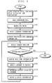
- the input part 4 provides the information processing part 2 with the starting point, specific point to pass by, and destination (step S101), all of which are set by the driver.
- the information processing part 2 then reads, from the cartographic data storage part 7, cartographic data needed for route search between the starting point and the destination (step S102). Based on the read cartographic data, the information processing part 2 searches for an applicable guidance route between those two points (if any specific point is specified to pass by, route search is made in consideration thereof) (step S103). Note that, route search is made under the Dijkstra algorithm, for example, which is well known.
- the information processing part 2 selects landmarks for route guidance to the destination (step S104). Specifically, in step S104, the information processing part 2 reads, from the landmark information storage 8, the attribute information 818 for each of the landmarks to be displayed during the route guidance.
- the information processing part 2 then executes update processing to the landmark information about the landmarks selected in step S104 (step S105) .
- the information processing part 2 outputs the attribute information 818 read in step S104 to the communications part 6 together with an instruction to confirm whether the landmark information has been updated.
- the communications part 6 establishes a communications path between a center station (not shown) to transmit ID numbers and version numbers found in the received attribute information.
- the center station searches for any corresponding landmark information among those stored in itself based on the received ID numbers. Then, the center station compares whether the found landmark information and the one came from the communications part 6 are identical in version number. If identical, it means that the landmark information in the navigation device 1 is the latest, and there is no need for update.
- the center station transmits a notification telling no update required to the communications part 6 of the navigation device 1.
- the notification is then outputted from the communications part 6 to the information processing part 2.
- the information processing part 2 does not update the landmark information. If the version numbers are not identical, the center station transmits the landmark information stored in itself to the communications part 6 as the latest. From the communications part 6, the landmark information goes to the information processing part 2 and then the landmark information storage part 8, and is stored therein as the latest landmark information.
- update processing is sequentially carried out on every landmark information selected in step S104.
- the information processing part 2 reads the vehicle's current location detected by the position detection part 9 (step S106) to see whether the vehicle has reached the destination (step S107). If not yet, the information processing part 2 acquires various real-time information from the real-time information acquisition part 10 (step S108). As already mentioned, the real-time information in this embodiment is the gas level and time.
- the information processing part 2 selects a landmark to process first (step S109).
- selected herein is one among those selected in step S104 (i.e., those found on the searched guidance route) which is found currently closest ahead of the vehicle.
- the landmark selected in this step may be the one not closest but several landmarks ahead.
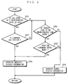
- the information processing part 2 refers to the real-time information from the real-time information acquisition part 10 to determine the display state of the landmark (step S110) . See FIG. 4 for the details of the subroutine step S110.
- the information processing part 2 determines whether the gas level indicated by the real-time information is equal to or lower than the predetermined level (step S201). If equal to or lower, the information processing part 2 determines whether the landmark type is a gas station (step S202). This determination is based on the type information in the attribute information 818. If the landmark type is the gas station, the information processing part 2 generates emphatic display information about the landmark (step S203). The information processing part 2 also executes the emphatic display execution file 817 in the landmark information.
- the information processing part 2 initially defines the landmark by display position, and then following the instructions 806 and 807, reads any corresponding image data (e.g., 2D image data, polygon data, vector data) from the landmark information storage part 8. The information processing part 2 then executes the instructions 808 to 814, thereby generating moving image data to animate the landmark on the display.
- the moving image data is temporarily stored in the information processing part 2.
- step S201 if the gas level is determined as exceeding the predetermined level, or if the landmark to process is not a gas station, the information processing part 2 determines whether now is the time in a predetermined time range, which is specifically set for the mealtime (e.g., 12:00 to 13:00, and 18:00 to 19:00) (step S204). If yes, the information processing part 2 determines whether the landmark is a facility that serves meals (step S205). Such facility includes a restaurant, cafeteria, café, rest area, and the like. This determination is made by referring to the type information in the attribute information 818. If the landmark is such facility, the information processing part 2 generates emphatic display information about the landmark (step S203).
- a predetermined time range which is specifically set for the mealtime (e.g., 12:00 to 13:00, and 18:00 to 19:00)
- the information processing part 2 If determined now is not the time in the predetermined time range in step S204, or if determined the landmark is not such facility in step S205, the information processing part 2 generates normal display information about the landmark (step S206). At this time, the information processing part 2 refers to the shape information 815 in the landmark information 802 to read any corresponding image data (e.g., 2D image data, polygon data, vector data) from the landmark information storage part 8. The information processing part 2 also defines the landmark by display position by referring to the positional information 816 in the landmark information 802. Thus read image data and defined display position are both temporarily stored in the information processing part 2. After step S203 or S206, the procedure returns to the main routine in FIG. 3.
- the procedure returns to the main routine in FIG. 3.
- the information processing part 2 executes output processing for the guidance information (step S111).
- the information processing part 2 brings the output part 5 to display the map, route, and landmarks.
- the information processing part 2 outputs, to the output part 5, the emphatic display information (moving image data) generated in step S203.
- the normal display information display position and image data generated in step S206.
- the output part 5 displays the landmarks in the emphatic or normal status. Thereafter, the procedure repeats steps S106 to S111 until the vehicle reaches the destination, and this is the end of the operation of the information processing part 2.
- the real-time information is the gas level and time, but surely any other information will do to change the landmark type to be displayed.
- the landmark to be selected may be a shop where umbrellas are available, or with date, the landmark to be displayed on birthdays may be a shop where flowers are available.
- the landmark type is the discrimination factor for emphatic display in the embodiment, and this is not restrictive.
- the attribute information 818 may previously include such information as specifying those days. The same is applicable to a specific time, and included in the attribute information 818 in this case is information specifying such specific time.
- the landmark is exemplarily animated. This is surely not restrictive, and the landmark may be flashed or displayed with some messages. In another manner, the landmark may be displayed with sound.
- the navigation device here is presumably equipped in a vehicle.
- the navigation device may be any type as far as displaying a guidance route on a map, and may be carried by a stroller, for example.
Landscapes
- Engineering & Computer Science (AREA)
- Radar, Positioning & Navigation (AREA)
- Remote Sensing (AREA)
- Automation & Control Theory (AREA)
- Physics & Mathematics (AREA)
- General Physics & Mathematics (AREA)
- Navigation (AREA)
- Traffic Control Systems (AREA)
- Processing Or Creating Images (AREA)
- Position Fixing By Use Of Radio Waves (AREA)
- Instructional Devices (AREA)
Applications Claiming Priority (2)
| Application Number | Priority Date | Filing Date | Title |
|---|---|---|---|
| JP2000010930A JP3717045B2 (ja) | 2000-01-19 | 2000-01-19 | ナビゲーション装置 |
| JP2000010930 | 2000-01-19 |
Publications (3)
| Publication Number | Publication Date |
|---|---|
| EP1118838A2 EP1118838A2 (en) | 2001-07-25 |
| EP1118838A3 EP1118838A3 (en) | 2004-08-11 |
| EP1118838B1 true EP1118838B1 (en) | 2006-11-02 |
Family
ID=18538878
Family Applications (1)
| Application Number | Title | Priority Date | Filing Date |
|---|---|---|---|
| EP01101111A Expired - Lifetime EP1118838B1 (en) | 2000-01-19 | 2001-01-18 | Navigation device |
Country Status (4)
| Country | Link |
|---|---|
| US (1) | US6442478B2 (enExample) |
| EP (1) | EP1118838B1 (enExample) |
| JP (1) | JP3717045B2 (enExample) |
| DE (1) | DE60124157T2 (enExample) |
Families Citing this family (30)
| Publication number | Priority date | Publication date | Assignee | Title |
|---|---|---|---|---|
| US6574556B2 (en) * | 2001-08-22 | 2003-06-03 | Matsushita Electric Industial Co., Ltd. | System and associated method of integrating subscriber based traffic navigation and hospitality data with a global positioning system |
| JP4603219B2 (ja) * | 2001-12-27 | 2010-12-22 | 株式会社ゼンリン | 電子地図データ供給装置、および、地図表示装置 |
| JP3933929B2 (ja) * | 2001-12-28 | 2007-06-20 | アルパイン株式会社 | ナビゲーション装置 |
| CN100555362C (zh) * | 2004-04-21 | 2009-10-28 | 三菱电机株式会社 | 设施显示装置 |
| WO2005119178A1 (en) * | 2004-06-02 | 2005-12-15 | Athena Technologies, Inc. | Image-augmented inertial navigation system (iains) and method |
| US7421341B1 (en) | 2004-06-30 | 2008-09-02 | Navteq North America, Llc | Method of collecting information for a geographic database for use with a navigation system |
| US7266447B2 (en) * | 2004-06-30 | 2007-09-04 | Navteq North America, Llc. | Method of collecting information for a geographic database for use with a navigation system |
| US7149626B1 (en) | 2004-06-30 | 2006-12-12 | Navteq North America, Llc | Method of operating a navigation system |
| US20060004514A1 (en) * | 2004-06-30 | 2006-01-05 | Bennett James R | Method of collecting information for a geographic database for use with a navigation system |
| US8751156B2 (en) | 2004-06-30 | 2014-06-10 | HERE North America LLC | Method of operating a navigation system using images |
| JP4696248B2 (ja) * | 2004-09-28 | 2011-06-08 | 国立大学法人 熊本大学 | 移動体ナビゲート情報表示方法および移動体ナビゲート情報表示装置 |
| US20060253246A1 (en) * | 2005-04-18 | 2006-11-09 | Cera Christopher D | Data-driven combined traffic/weather views |
| US8626440B2 (en) * | 2005-04-18 | 2014-01-07 | Navteq B.V. | Data-driven 3D traffic views with the view based on user-selected start and end geographical locations |
| US7765055B2 (en) * | 2005-04-18 | 2010-07-27 | Traffic.Com, Inc. | Data-driven traffic views with the view based on a user-selected object of interest |
| US8781736B2 (en) * | 2005-04-18 | 2014-07-15 | Navteq B.V. | Data-driven traffic views with continuous real-time rendering of traffic flow map |
| WO2006121986A2 (en) | 2005-05-06 | 2006-11-16 | Facet Technology Corp. | Network-based navigation system having virtual drive-thru advertisements integrated with actual imagery from along a physical route |
| WO2007029455A1 (ja) * | 2005-09-07 | 2007-03-15 | Pioneer Corporation | 風景単調度演算装置及び方法 |
| US20070299607A1 (en) * | 2006-06-27 | 2007-12-27 | Verizon Laboratories Inc. | Driving directions with landmark data |
| US9031777B2 (en) * | 2006-08-08 | 2015-05-12 | Verizon Patent And Licensing Inc. | Driving directions with selective printing |
| JP2007102238A (ja) * | 2006-10-23 | 2007-04-19 | Zenrin Co Ltd | 3次元表示可能な電子地図データを利用した情報提供 |
| US8744758B2 (en) * | 2006-12-19 | 2014-06-03 | Verizon Patent And Licensing Inc. | Driving directions printed text scaling |
| JP2008298740A (ja) * | 2007-06-04 | 2008-12-11 | Xanavi Informatics Corp | ナビゲーション装置 |
| JP2009031308A (ja) * | 2008-10-30 | 2009-02-12 | Zenrin Co Ltd | ナビゲーションシステム、および、電子地図データのデータ構造 |
| JP5569365B2 (ja) * | 2010-11-30 | 2014-08-13 | アイシン・エィ・ダブリュ株式会社 | 案内装置、案内方法、及び案内プログラム |
| DE102011077948A1 (de) * | 2011-06-22 | 2012-12-27 | Robert Bosch Gmbh | Verfahren zum Bereitstellen von Fahrempfehlungen, Navigationsgerät |
| EP2543964B1 (en) | 2011-07-06 | 2015-09-02 | Harman Becker Automotive Systems GmbH | Road Surface of a three-dimensional Landmark |
| DE102012212016A1 (de) * | 2012-07-10 | 2014-05-22 | Bayerische Motoren Werke Aktiengesellschaft | Verfahren zum Betreiben einer optischen Anzeigevorrichtung eines Fahrzeugs |
| DE102012212015A1 (de) | 2012-07-10 | 2014-05-22 | Bayerische Motoren Werke Aktiengesellschaft | Vorrichtung zum Betreiben einer oder mehrerer optischer Anzeigevorrichtungen eines Fahrzeugs |
| US10024683B2 (en) * | 2016-06-06 | 2018-07-17 | Uber Technologies, Inc. | User-specific landmarks for navigation systems |
| CN107423445B (zh) | 2017-08-10 | 2018-10-30 | 腾讯科技(深圳)有限公司 | 一种地图数据处理方法、装置及存储介质 |
Family Cites Families (11)
| Publication number | Priority date | Publication date | Assignee | Title |
|---|---|---|---|---|
| JPH0616320B2 (ja) * | 1987-04-08 | 1994-03-02 | 株式会社日立製作所 | 自動車運転案内装置および方法 |
| JPH07306054A (ja) * | 1994-05-11 | 1995-11-21 | Brother Ind Ltd | ナビゲーションシステム |
| US5850618A (en) * | 1994-12-28 | 1998-12-15 | Aisin Aw Co., Ltd. | Navigation device |
| KR100235240B1 (ko) * | 1995-10-31 | 1999-12-15 | 모리 하루오 | 네비게이션(navigation) 장치 |
| JPH09304090A (ja) * | 1996-05-21 | 1997-11-28 | Canon Inc | 地図情報処理装置 |
| KR100288284B1 (ko) * | 1996-09-30 | 2001-05-02 | 모리 하루오 | 차량용 네비게이션장치 |
| JP3919855B2 (ja) * | 1996-10-17 | 2007-05-30 | 株式会社ザナヴィ・インフォマティクス | ナビゲーション装置 |
| EP0944032A4 (en) * | 1997-07-02 | 2001-02-28 | Mitsubishi Electric Corp | VEHICLE BROWSER |
| JP3500928B2 (ja) * | 1997-09-17 | 2004-02-23 | トヨタ自動車株式会社 | 地図データ処理装置、地図データ処理方法および地図データ処理システム |
| JP3546659B2 (ja) * | 1997-09-25 | 2004-07-28 | トヨタ自動車株式会社 | 車両用データ処理システム、そのシステムを構成する車載端末装置およびナビゲーション装置 |
| JP3463588B2 (ja) | 1999-01-14 | 2003-11-05 | 日産自動車株式会社 | 車両経路誘導システム |
-
2000
- 2000-01-19 JP JP2000010930A patent/JP3717045B2/ja not_active Expired - Fee Related
-
2001
- 2001-01-17 US US09/760,821 patent/US6442478B2/en not_active Expired - Fee Related
- 2001-01-18 DE DE60124157T patent/DE60124157T2/de not_active Expired - Fee Related
- 2001-01-18 EP EP01101111A patent/EP1118838B1/en not_active Expired - Lifetime
Also Published As
| Publication number | Publication date |
|---|---|
| JP3717045B2 (ja) | 2005-11-16 |
| DE60124157D1 (de) | 2006-12-14 |
| EP1118838A2 (en) | 2001-07-25 |
| US20010008991A1 (en) | 2001-07-19 |
| DE60124157T2 (de) | 2007-09-20 |
| US6442478B2 (en) | 2002-08-27 |
| JP2001201355A (ja) | 2001-07-27 |
| EP1118838A3 (en) | 2004-08-11 |
Similar Documents
| Publication | Publication Date | Title |
|---|---|---|
| EP1118838B1 (en) | Navigation device | |
| US6388582B2 (en) | Lane guidance display method, and navigation device and recording medium for realizing the method | |
| US6374180B1 (en) | Points of interest for a navigation system | |
| US7769541B2 (en) | Vehicle navigation system and method of generating updated map data for vehicle navigation system | |
| US8612153B2 (en) | Apparatus and method for map data management | |
| US7584051B2 (en) | Navigation system and program for the same | |
| US9052212B2 (en) | Dynamic destination map display for navigation system | |
| US20020133292A1 (en) | Route search method in navigation system | |
| JP2001264099A (ja) | 車両用ナビゲーション装置 | |
| JP2002340604A (ja) | ナビゲーション装置及び目的地入力方法 | |
| JP4437816B2 (ja) | ナビゲーション装置、経路探索方法、経路探索プログラムおよびコンピュータ読み取り可能な記録媒体 | |
| JP2003148977A (ja) | ナビゲーション装置 | |
| JP2017032421A (ja) | 電子装置、経路案内プログラムおよび経路案内システム | |
| JP2000314634A (ja) | 移動体用地図情報表示システム | |
| JP2005132291A (ja) | 車両制御システム | |
| JP2000074681A (ja) | 車両用ナビゲーション装置及びその処理を行うプログラムを記録した記録媒体 | |
| JP2003148974A (ja) | ナビゲーション装置の周辺施設探索表示方法 | |
| JP2009150796A (ja) | ナビゲーション装置、その地図情報アップデート方法および地図情報アップデートプログラム | |
| JP2001264083A (ja) | ナビゲーション装置の最寄り施設表示方法 | |
| KR101192820B1 (ko) | 네비게이션 시스템 | |
| EP1302752A2 (en) | Displaying the destination in a navigation apparatus | |
| JP2003042797A (ja) | 位置情報表示装置及びその方法並びにプログラム | |
| JP2001201356A (ja) | ナビゲーション装置 | |
| JP2002156238A (ja) | ナビゲーション装置 | |
| JP2005114668A (ja) | ナビゲーション装置及び施設創設時情報記憶方法 |
Legal Events
| Date | Code | Title | Description |
|---|---|---|---|
| PUAI | Public reference made under article 153(3) epc to a published international application that has entered the european phase |
Free format text: ORIGINAL CODE: 0009012 |
|
| AK | Designated contracting states |
Kind code of ref document: A2 Designated state(s): AT BE CH CY DE DK ES FI FR GB GR IE IT LI LU MC NL PT SE TR |
|
| AX | Request for extension of the european patent |
Free format text: AL;LT;LV;MK;RO;SI |
|
| RIC1 | Information provided on ipc code assigned before grant |
Ipc: 7G 01C 21/36 A Ipc: 7G 08G 1/0969 B |
|
| PUAL | Search report despatched |
Free format text: ORIGINAL CODE: 0009013 |
|
| AK | Designated contracting states |
Kind code of ref document: A3 Designated state(s): AT BE CH CY DE DK ES FI FR GB GR IE IT LI LU MC NL PT SE TR |
|
| AX | Request for extension of the european patent |
Extension state: AL LT LV MK RO SI |
|
| RIN1 | Information on inventor provided before grant (corrected) |
Inventor name: SAKAMOTO, KIYOMI Inventor name: HAMADA, HIROYUKI Inventor name: UEYAMA, YOSHIKI |
|
| 17P | Request for examination filed |
Effective date: 20041005 |
|
| AKX | Designation fees paid |
Designated state(s): DE FR GB |
|
| RBV | Designated contracting states (corrected) |
Designated state(s): DE FR GB |
|
| GRAP | Despatch of communication of intention to grant a patent |
Free format text: ORIGINAL CODE: EPIDOSNIGR1 |
|
| GRAS | Grant fee paid |
Free format text: ORIGINAL CODE: EPIDOSNIGR3 |
|
| GRAA | (expected) grant |
Free format text: ORIGINAL CODE: 0009210 |
|
| AK | Designated contracting states |
Kind code of ref document: B1 Designated state(s): DE FR GB |
|
| REG | Reference to a national code |
Ref country code: GB Ref legal event code: FG4D |
|
| REF | Corresponds to: |
Ref document number: 60124157 Country of ref document: DE Date of ref document: 20061214 Kind code of ref document: P |
|
| ET | Fr: translation filed | ||
| PLBE | No opposition filed within time limit |
Free format text: ORIGINAL CODE: 0009261 |
|
| STAA | Information on the status of an ep patent application or granted ep patent |
Free format text: STATUS: NO OPPOSITION FILED WITHIN TIME LIMIT |
|
| 26N | No opposition filed |
Effective date: 20070803 |
|
| PGFP | Annual fee paid to national office [announced via postgrant information from national office to epo] |
Ref country code: DE Payment date: 20090115 Year of fee payment: 9 |
|
| PGFP | Annual fee paid to national office [announced via postgrant information from national office to epo] |
Ref country code: GB Payment date: 20090114 Year of fee payment: 9 |
|
| PGFP | Annual fee paid to national office [announced via postgrant information from national office to epo] |
Ref country code: FR Payment date: 20090113 Year of fee payment: 9 |
|
| GBPC | Gb: european patent ceased through non-payment of renewal fee |
Effective date: 20100118 |
|
| REG | Reference to a national code |
Ref country code: FR Ref legal event code: ST Effective date: 20100930 |
|
| PG25 | Lapsed in a contracting state [announced via postgrant information from national office to epo] |
Ref country code: FR Free format text: LAPSE BECAUSE OF NON-PAYMENT OF DUE FEES Effective date: 20100201 |
|
| PG25 | Lapsed in a contracting state [announced via postgrant information from national office to epo] |
Ref country code: DE Free format text: LAPSE BECAUSE OF NON-PAYMENT OF DUE FEES Effective date: 20100803 |
|
| PG25 | Lapsed in a contracting state [announced via postgrant information from national office to epo] |
Ref country code: GB Free format text: LAPSE BECAUSE OF NON-PAYMENT OF DUE FEES Effective date: 20100118 |