EP1035531A2 - Système fournissant de l'information pour unités mobiles - Google Patents
Système fournissant de l'information pour unités mobiles Download PDFInfo
- Publication number
- EP1035531A2 EP1035531A2 EP00103452A EP00103452A EP1035531A2 EP 1035531 A2 EP1035531 A2 EP 1035531A2 EP 00103452 A EP00103452 A EP 00103452A EP 00103452 A EP00103452 A EP 00103452A EP 1035531 A2 EP1035531 A2 EP 1035531A2
- Authority
- EP
- European Patent Office
- Prior art keywords
- terminal
- map
- information
- server
- destination
- Prior art date
- Legal status (The legal status is an assumption and is not a legal conclusion. Google has not performed a legal analysis and makes no representation as to the accuracy of the status listed.)
- Granted
Links
Images


Classifications
-
- G—PHYSICS
- G06—COMPUTING; CALCULATING OR COUNTING
- G06Q—INFORMATION AND COMMUNICATION TECHNOLOGY [ICT] SPECIALLY ADAPTED FOR ADMINISTRATIVE, COMMERCIAL, FINANCIAL, MANAGERIAL OR SUPERVISORY PURPOSES; SYSTEMS OR METHODS SPECIALLY ADAPTED FOR ADMINISTRATIVE, COMMERCIAL, FINANCIAL, MANAGERIAL OR SUPERVISORY PURPOSES, NOT OTHERWISE PROVIDED FOR
- G06Q50/00—Systems or methods specially adapted for specific business sectors, e.g. utilities or tourism
- G06Q50/10—Services
-
- G—PHYSICS
- G08—SIGNALLING
- G08G—TRAFFIC CONTROL SYSTEMS
- G08G1/00—Traffic control systems for road vehicles
- G08G1/09—Arrangements for giving variable traffic instructions
- G08G1/0962—Arrangements for giving variable traffic instructions having an indicator mounted inside the vehicle, e.g. giving voice messages
- G08G1/0968—Systems involving transmission of navigation instructions to the vehicle
- G08G1/096805—Systems involving transmission of navigation instructions to the vehicle where the transmitted instructions are used to compute a route
- G08G1/096811—Systems involving transmission of navigation instructions to the vehicle where the transmitted instructions are used to compute a route where the route is computed offboard
-
- G—PHYSICS
- G01—MEASURING; TESTING
- G01C—MEASURING DISTANCES, LEVELS OR BEARINGS; SURVEYING; NAVIGATION; GYROSCOPIC INSTRUMENTS; PHOTOGRAMMETRY OR VIDEOGRAMMETRY
- G01C21/00—Navigation; Navigational instruments not provided for in groups G01C1/00 - G01C19/00
- G01C21/26—Navigation; Navigational instruments not provided for in groups G01C1/00 - G01C19/00 specially adapted for navigation in a road network
- G01C21/34—Route searching; Route guidance
- G01C21/36—Input/output arrangements for on-board computers
- G01C21/3626—Details of the output of route guidance instructions
- G01C21/3655—Timing of guidance instructions
-
- G—PHYSICS
- G01—MEASURING; TESTING
- G01C—MEASURING DISTANCES, LEVELS OR BEARINGS; SURVEYING; NAVIGATION; GYROSCOPIC INSTRUMENTS; PHOTOGRAMMETRY OR VIDEOGRAMMETRY
- G01C21/00—Navigation; Navigational instruments not provided for in groups G01C1/00 - G01C19/00
- G01C21/38—Electronic maps specially adapted for navigation; Updating thereof
- G01C21/3885—Transmission of map data to client devices; Reception of map data by client devices
- G01C21/3889—Transmission of selected map data, e.g. depending on route
-
- G—PHYSICS
- G08—SIGNALLING
- G08G—TRAFFIC CONTROL SYSTEMS
- G08G1/00—Traffic control systems for road vehicles
- G08G1/09—Arrangements for giving variable traffic instructions
- G08G1/0962—Arrangements for giving variable traffic instructions having an indicator mounted inside the vehicle, e.g. giving voice messages
- G08G1/0968—Systems involving transmission of navigation instructions to the vehicle
- G08G1/096805—Systems involving transmission of navigation instructions to the vehicle where the transmitted instructions are used to compute a route
- G08G1/096811—Systems involving transmission of navigation instructions to the vehicle where the transmitted instructions are used to compute a route where the route is computed offboard
- G08G1/096816—Systems involving transmission of navigation instructions to the vehicle where the transmitted instructions are used to compute a route where the route is computed offboard where the complete route is transmitted to the vehicle at once
-
- G—PHYSICS
- G08—SIGNALLING
- G08G—TRAFFIC CONTROL SYSTEMS
- G08G1/00—Traffic control systems for road vehicles
- G08G1/09—Arrangements for giving variable traffic instructions
- G08G1/0962—Arrangements for giving variable traffic instructions having an indicator mounted inside the vehicle, e.g. giving voice messages
- G08G1/0968—Systems involving transmission of navigation instructions to the vehicle
- G08G1/096805—Systems involving transmission of navigation instructions to the vehicle where the transmitted instructions are used to compute a route
- G08G1/096811—Systems involving transmission of navigation instructions to the vehicle where the transmitted instructions are used to compute a route where the route is computed offboard
- G08G1/096822—Systems involving transmission of navigation instructions to the vehicle where the transmitted instructions are used to compute a route where the route is computed offboard where the segments of the route are transmitted to the vehicle at different locations and times
-
- G—PHYSICS
- G08—SIGNALLING
- G08G—TRAFFIC CONTROL SYSTEMS
- G08G1/00—Traffic control systems for road vehicles
- G08G1/09—Arrangements for giving variable traffic instructions
- G08G1/0962—Arrangements for giving variable traffic instructions having an indicator mounted inside the vehicle, e.g. giving voice messages
- G08G1/0968—Systems involving transmission of navigation instructions to the vehicle
- G08G1/096833—Systems involving transmission of navigation instructions to the vehicle where different aspects are considered when computing the route
- G08G1/096838—Systems involving transmission of navigation instructions to the vehicle where different aspects are considered when computing the route where the user preferences are taken into account or the user selects one route out of a plurality
-
- G—PHYSICS
- G08—SIGNALLING
- G08G—TRAFFIC CONTROL SYSTEMS
- G08G1/00—Traffic control systems for road vehicles
- G08G1/09—Arrangements for giving variable traffic instructions
- G08G1/0962—Arrangements for giving variable traffic instructions having an indicator mounted inside the vehicle, e.g. giving voice messages
- G08G1/0968—Systems involving transmission of navigation instructions to the vehicle
- G08G1/096855—Systems involving transmission of navigation instructions to the vehicle where the output is provided in a suitable form to the driver
- G08G1/096861—Systems involving transmission of navigation instructions to the vehicle where the output is provided in a suitable form to the driver where the immediate route instructions are output to the driver, e.g. arrow signs for next turn
-
- G—PHYSICS
- G08—SIGNALLING
- G08G—TRAFFIC CONTROL SYSTEMS
- G08G1/00—Traffic control systems for road vehicles
- G08G1/09—Arrangements for giving variable traffic instructions
- G08G1/0962—Arrangements for giving variable traffic instructions having an indicator mounted inside the vehicle, e.g. giving voice messages
- G08G1/0968—Systems involving transmission of navigation instructions to the vehicle
- G08G1/096877—Systems involving transmission of navigation instructions to the vehicle where the input to the navigation device is provided by a suitable I/O arrangement
- G08G1/096894—Systems involving transmission of navigation instructions to the vehicle where the input to the navigation device is provided by a suitable I/O arrangement where input is assisted by the navigation device, i.e. the user does not type the complete name of the destination, e.g. using zip codes, telephone numbers, progressively selecting from initial letters
Definitions
- the present invention relates to an information terminal making accesses to a network and a server system providing information. More particularly, the present invention relates to an information providing system comprising an information terminal capable of making accesses to the Internet for information from a variety of places such as a home, a mobile body like a car or on a street while the user is walking and a server for providing such a terminal with information appropriate for a place where the terminal is used.
- JPA 10-105053 and 7-262494 disclose map information providing systems of a network type which are referred to hereafter as first and second prior arts respectively.
- map information is received in predetermined area units and, before a car moves from the present area to a next one, map information of the next area is received. After the map information of a next area has been received, that of the present area is erased.
- route information is stored at a center.
- a terminal transmits information on the present position and a destination to the center. In response to such information, the center transmits main information on the vicinity of the present position to the terminal.
- JPA 10-122885 discloses a navigation apparatus which is referred to hereafter as a third prior art.
- a travel route is entered to the main unit of the navigation apparatus via a computer for inputting a route.
- the navigation system determines a branch direction based on the entered travel route and the present position.
- JPA 7-332993 also discloses a navigation system which is referred to hereafter as a fourth prior art.
- the navigation system of the fourth prior art has a means for detecting crossings to be encountered from now on and complicated crossings.
- JPA 10-325734 discloses a fifth prior art wherein an operation to enter a desired destination is made simple. According to the fifth prior art, there is a conceivable technique of searching a word dictionary for candidates for a desired destination by using a wild card entered by the user and displaying the candidates found in the search, making it unnecessary for the user to enter the entire string of characters representing the desired destination.
- the Internet also has a page for rendering services of displaying the names of candidates for a location of interest by accepting the literal (written) phonetic transcription of the name or some kanji characters thereof. Let these Internet services be referred to as a sixth prior art.
- the Internet also provides services of showing a map and loading a new one for a predetermined range centering at a coordinate point from a server when it is desired to move a vehicle up or down or in the right or left direction from the present position on the displayed map.
- the services make use of a scroll button to move the position. Let these Internet services be referred to as a seventh prior art.
- the entire map of a next area is downloaded when a border of the present map is approached.
- the present prior art allows a used map to be deleted. Since a used map is erased not before the map of a next area is downloaded, however, the problem of an insufficient memory is not solved.
- the map of a next area is downloaded after a border of the present map is approached. It is thus quite within the bounds of possibility that the next map can not be all downloaded even after the border has been crossed due to, for example, the fact that the map is downloaded while the vehicle is passing through a tunnel. In this case, the user can not see the next map even after the vehicle has entered the next area.
- a next map is inadvertently downloaded, raising the communication charge.
- the map of the vicinity of the present position at which the terminal is located is downloaded on the basis of information on the present position.
- the sixth prior art has a problem that when the literal (written) phonetic transcription of the name of a place does not exactly match its stored spelling, candidates for the name of the place can not be displayed. Take “Oomikacho, Hitachi-city, Ibaraki Prefecture” as an example of a stored spelling. If user incorrectly enters a literal input “Hitachi-city Oomika” or “Oomikamura, Hitachi-city", the display for the place will not appear since the lateral input does not exactly match the stored spellings. Thus, the sixth prior art has a problem that an incorrect human input can not be handled.
- the service of displaying the map of a destination based on picture data entails a large amount of information which takes a long time to download and increases the communication charge.
- the information providing system of the present invention is provided with a terminal mounted on a vehicle and used for providing a route guide showing directions to a destination, a server for providing information including at least a map used in the route guide showing directions to the terminal and an information providing timing determination means in either the server or the terminal for determining timing to transmit information including at least the map from the server to the terminal.
- the information providing timing determination means keeps track of the position of the vehicle bearing the terminal to determine typically a time at which the vehicle arrives at a predetermined location as timing to download information including at least the map from the server to the terminal.
- the information providing timing determination means uses at least one of pieces of information on usable resources in the terminal at that time and information on a guide route leading to a destination to determine timing to transmit information including at least the map from the server to the terminal.
- either the server or the terminal employed in the information providing system of the present invention is provided with a means for computing information quantities of information including at least the map in accordance with information on resources available at that time in the terminal, and the server generates information to be transmitted to the terminal on the basis of the computed information quantities.
- the server is further provided with an index candidate place name providing means for executing the steps of receiving a string of characters entered by the user to the terminal and transmitted by the terminal to the server wherein the string of characters represents a portion of the place name of a destination to be used in the route guide showing directions to the destination searching a data base of place names by using an index formed from the string of characters for candidates for the place name of the destination matching the string of characters transmitting the candidate place names to the terminal and requesting the terminal to select one of the candidate place names, and a map providing means for transmitting a map for a selected candidate for the place name of the destination, which is transmitted by the terminal to the server, to the terminal.
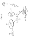
- Fig. 13 is an explanatory diagram showing a typical complete configuration of a information providing system provided by the present invention.
- a server 1302 and a provider 1304 are connected to an Internet network 1301.
- a terminal 1306 has a function to identify the present position by receiving a signal from a GPS satellite 1307.
- the server 1302 provides the terminal 1306 with a map in accordance with a request made by the terminal 1306.
- the terminal 1306 makes such a request by first establishing connection with the provider 1304 through a telephone network 1303 and then making an access to the Internet network 1301.
- a map typically according to the present position of the terminal 1306 is finally downloaded from the server 1302 to the terminal 1306.
- Fig. 1 is a block diagram showing a typical configuration of the terminal 1306 provided by the present invention.
- the terminal 1306 comprises a memory 101, a GPS 102, a position determination unit 103, an input unit 104, a processing unit 105, a display control unit 106, a map display determination unit 107, an external storage unit 108, a communication unit 109 and an audio output unit 110.
- the terminal 1306 receives data from the server 1302 through the communication unit 109.
- the data received from the server 1302 is stored in the memory 101 or the external storage unit 108 for later use.
- the GPS 102 determines the present position of the vehicle 1305 by measuring the latitude and the longitude of the present position of the vehicle 1305.
- the position determination unit 103 identifies what road and what place the vehicle 1305 is running on and located in on the basis of the latitude and the longitude of the present position of the vehicle 1305 computed by the GPS 102. That is to say, the position determination unit 103 maps the latitude and the longitude of the present position of the vehicle 1305 onto a map.
- the map display determination unit 107 forms a judgment as to whether or not the present position is a location to download a map.
- the display control unit 106 transfers data to be displayed to a display unit which is typically an instrument already installed in the vehicle 1305. It should be noted that, while the terminal 1306 of the present embodiment does not have a display unit, the terminal 1306 can also be configured to include a display unit.
- the input unit 104 is used for inputting information such as a destination.
- a remote controller is used as the input unit 104.
- a tablet for inputting hand-written data can also be used.
- the audio output unit 110 outputs a voice message originated by the terminal 1306 or the server 1302.
- the flowchart begins with a step 201 at which the GPS 102 employed in the terminal 1306 measures the position of the vehicle 1305.
- the flow of the processing then goes on to a step 202 at which literal information on a destination entered by the user by operating the terminal 1306 is stored in the memory 101 or the external storage unit 108.
- the reason why the literal information on a destination is kept in the terminal 1306 is that it is not necessary for the user to spend time and labor to reenter such information in case the engine of the vehicle 1305 is restarted after being once halted in the middle of a route leading to the destination.
- the need to reenter literal information on a destination in case the engine of the vehicle 1305 is restarted after being once halted is a load borne by the user.
- literal information on a destination is kept in the terminal 1306 also indicates that the vehicle 1305 is running on a route leading to the destination since a destination is deleted from the terminal 1306 as soon as the vehicle 1305 arrives at the destination as will be described later.
- the fact that literal information on a destination is not kept in the terminal 1306 indicates that the vehicle 1305 is still in the course of running on a route leading to the destination. In this case, it is necessary to newly set a destination.
- the position of the vehicle 1305 and the literal information on the destination are transmitted to the server 1302 by using the communication unit 109.
- a portable telephone is used as the communication unit 109.
- the terminal 1306 has a function to automatically make a telephone call to the server 1302 at that time and to automatically terminate the call at the end of the data transmission.
- the server 1302 receives the position of the vehicle 1305 and the literal information on the destination, searching a destination place-name data base for a destination corresponding to the literal information. It should be noted that, if a plurality of candidates for the destination are found in the search, the server 1302 transmits the candidates to the terminal 1306 and then receives information on a selected candidate for the destination from the terminal 1306. Details of the search of the data base for a destination will be explained later by referring to Fig. 23. It is also to be noted that the position of the vehicle 1305 transmitted by the terminal 1306 to the server 1302 is the latitude and the longitude of the position of the vehicle 1305.
- the user of the terminal 1306 typically enters the literal place name of a destination to be transmitted to the server 1302 as described above.
- the candidate place name of the destination eventually selected by the user is converted by the server 1302 into a latitude and a longitude of the destination represented by the selected candidate place name.
- the user may also enter the latitude and the longitude of the destination directly to the terminal 1306 to be transmitted by the terminal 1306 to the server 1302 in place of the lateral place name of the destination. In this case, the operation to search the destination place-name data base for candidate place names and to let the user select one of the candidates can be eliminated.
- a location to display a map is referred to hereafter as a map display location.
- An example of the map display location is a crossing at which the vehicle 1305 will make a turn. If the vehicle 1305 goes straight along a road through a crossing, however, it is not necessary to download a map. Such a crossing is not regarded as a map display location.
- an interchange where the vehicle 1305 gets off from an expressway may also be a map display location.
- the start of a road with a name different from the present road is also a map display location.
- a map display location can be found by using a technique for recognizing a crossing at which the vehicle 1305 will make a turn.
- the server 1302 transmits the information on a route computed at the step 209 and the map display location found at the step 210 to the terminal 1306.
- the terminal 1306 receives the computed information on the route and the identified map display location from the server 1302, storing them in the memory 101.
- the received information on the route is used to check if that the vehicle 1305 has slipped off from the route. At this step, preparatory work has been completed.
- the GPS 102 keeps measuring the position of the vehicle 1305 at a step 205 and processing is carried out in accordance with the newly measured position.
- the present position of the vehicle 1305 is examined to determine whether or not the position is the map display location, an enlarged-map display location, a destination or another. If the vehicle 1305 is determined to have slipped out from the due route, the flow of the processing goes back to the step 203.
- the flow of the processing goes on to a step 213 at which the terminal 1306 requests the server 1302 to transmit a map of the vicinity of the map display location or the enlarged map of the enlarged-map display location to the terminal 1306 through the communication unit 109.
- the terminal 1306 automatically makes a telephone call to the server 1302, requesting the server 1302 to transmit the map.
- the server 1302 searches a map data base for the requested map.
- the server 1302 further determines the type of the requested map to be transmitted to the terminal 1306.
- the flow of the processing goes on to a step 216 at which the map is transmitted to the terminal 1306 at the default scale. If the type found to be an enlarge type, on the other hand, the flow of the processing goes on to a step 217 at which an enlarged map is transmitted to the terminal 1306.
- the terminal 1306 receives the map or the enlarged map transmitted by the server 1302 at a step 206 or 207 respectively, displaying the map or the enlarged map on a display unit not shown in the figure through the display control unit 106.
- the enlarged map needs to be displayed when the terminal 1306 is approaching the enlarged-map display location, requesting such an enlarged map.
- the terminal 1306 automatically terminates the telephone call at the end of the map transmission and the server 1302 identifies the user using the terminal 1306 from the telephone number of the call.
- the terminal 1306 is capable of enlarging a map provided that the map is vector data. If the map is image data, on the other hand, the terminal 1306 is not capable of enlarging the map. In this case, the terminal 1306 must specify an enlarged map in the request for a map made at the step 213 to the server 1302.
- the flow of the processing goes on to a step 212 at which the destination and information on a route leading to the destination are erased. The processing is then ended.
- the flow of the processing goes on to a step 208 at which a display appearing on the display unit is erased.
- the vehicle 1305 if the vehicle 1305 is at a position separated away from the map display location, the enlarged-display location and the destination, nothing needs to be displayed. However, information on landmarks close to the position of the vehicle 1305 can be left on the display screen even if others are erased.
- a map is not necessarily downloaded from the server 1302 to the terminal 1306 even if the vehicle 1305 is approaching a map display location.
- a notice to download a map is given to the user of the terminal 1306 as the vehicle 1305 arrives at a position in front of the map display location.
- a typical technique to give such a notice is to display a window 1601 as shown in Fig. 16.
- the terminal 1306 may issue an oral message saying: "The map of a next area will be downloaded.” If the user does not react to the window 1601 and the oral message, the terminal 1306 starts an operation to download the map. If the user reveals an intention to cancel the downloading of the map by using some techniques via the input unit 104, on the other hand, the terminal 1306 does not download the map.
- a remote controller is used as the input unit 104.
- the processing represented by the flowchart shown in Fig. 2 is carried out with the power supply of the terminal 1306 turned on.
- the power supply of the terminal 1306 may be turned off when the engine of the vehicle 1305 is halted for example at a rest area on the route.
- the terminal 1306 checks whether or not a destination is stored therein. A destination stored in the terminal 1306 indicates that the vehicle 1305 has not arrived at the destination. In this case, the processing is resumed from the step 205. If no destination is stored in the terminal 1306, on the other hand, the processing is resumed from the step 201.
- Fig. 3 is an explanatory diagram showing typical transitions of a display screen generated by processing of the present invention.
- a screen 301 is a typical display showing the vehicle 1305 running straight along a road.
- the screen 301 does not show anything.
- Landmarks in close proximity to the position of the vehicle 1305 can be displayed.
- An example of a landmark is a restaurant.
- information on a restaurant such as its menu and food prices can also be displayed on the display unit as well.
- a screen 302 is a typical display showing a map of a map display location 305 approached by the vehicle 1305.
- the terminal 1306 determines whether or not the vehicle 1305 is approaching a map display location 305 by comparing the distance between the position 304 of the vehicle 1305 and the map display location 305 with a predetermined length. It is of course possible to compute the distance between the map display location 305 and the position 304 which is found by the GPS 102.
- a direction to be followed by the vehicle 1305 is also displayed as shown by an arrow 306.
- the vehicle 1305 is supposed to make a left turn at the map display location 305.
- an enlarged map of the vicinity of a cross at the map display location 305 is displayed as shown on a screen 303.
- the screen 303 also displays the position 304 of the vehicle 1305 and the arrow 306.
- an enlarged map can be produced by the terminal 1306 in case vector data has been received by the terminal 1306.
- an enlarged map needs to be downloaded from the server 1302.
- the vehicle 1305 After the enlarged map is displayed, the vehicle 1305 makes a left turn at the crossing and the screen 303 disappears from the display unit, ending the display of the map. Then, as the vehicle 1305 is running straight along a road again, the screen does not show anything except probably landmarks in close proximity to the position of the vehicle 1305. As an alternative, a rough map like one shown in Fig. 11 can be displayed. This screen is displayed for a straight run as is the case with the screen 301 described above.
- the terminal 1306 In order to display information on a landmark approached by the vehicle 1305, it is necessary for the terminal 1306 to know the location of the landmark in advance. It is thus necessary to acquire information on the location from the server 1302 beforehand. Then, the terminal 1306 keeps track of the position of the vehicle 1305 and forms a judgment as to whether or not the vehicle 1305 has approached the landmark.
- Fig. 4 is a block diagram showing a typical configuration of the server 1302 provided by the present invention.
- the server 1302 comprises a communication driver 401, an input reception unit 402, a search engine 403, a member-information data base 404, a map data base 405, a place-name word dictionary 412, a route calculation unit 406, an image development unit 407, a map display location determination unit 408, an HTML conversion unit 409, an accounting control unit 410, an image/vector determination unit 411 and a thinning determination unit 412'.
- server 1302 all requests made by the terminal 1306 are received by the communication driver 401.
- Data received by the server 1302 is examined by the input reception unit 402 to determine what kind of data it is.
- the input reception unit 402 determines whether or not the member has a right to make an access to the server 1302. If the member does not have such an access, the terminal 1306 is notified that no further services can be rendered. As an alternative, only an image data can be provided to such a member.
- User information is supplied to the accounting control unit 410 which searches the member-information data base 404 for member information matching the user information and determines which member is supposed to pay the cost of communication.
- the ID of the member is stored in the terminal 1306.
- the information on the position of the vehicle 1305 and a destination is received from the user of the terminal 1306, the information is supplied to the input reception unit 402 of the server 1302 by way of the communication driver 401 as is the case with the user information described above.
- the information on the position of the vehicle 1305 is the latitude and the longitude of the position.
- the information on a destination is the latitude and the longitude of the destination which can be a result of conversion of the name place of the destination or obtained directly from the terminal 1306 as described above.
- the long-distance prefix of a telephone number or the zip code of the destination can be used instead of the latitude and the longitude thereof.
- the long-distance prefix telephone number or the zip code of the destination must be converted into the latitude and the longitude thereof by typically the input reception unit 402.
- the input reception unit 402 transfers the position of the vehicle 1305 and literal information on the destination to the search engine 403.
- the search engine 403 searches the place-name word dictionary 412 for the latitude and the longitude of the destination matching the literal information. Then, the search engine 403 searches the map data base 405 for a map matching the latitude and the longitude. The search engine 403 then outputs an index in the map data base 405 for the storage address of a mesh including the map of the destination.
- the map data base 405 can be an ordinary map data base generally used. It is desirable, however, to have a map data base that can be used for storing vector map data.
- the index obtained in the search is transferred to a route computing unit 406 which computes a route from the position of the vehicle 1305 to the destination.
- the computed route is then transferred to the map display location determination unit 408 which determines a location at which the map is to be downloaded to the terminal 1306.
- the image/vector determination unit 411 for determining the type of the map to be transmitted to the terminal 1306 determines whether to transmit an image map or a vector map to the terminal 1306 in dependence on whether or not the user is a member. If the user is a member, a vector map is transmitted to the terminal 1306. Otherwise, an image map is transmitted.
- the terminal 1306 is capable of enlarging and shrinking a vector map with a high degree of freedom. Thus, even if the user desires a map with a scale different from that of the map received by the terminal 1306 from the server 1302, it is not necessary to again download the desired map from the server 1302. As a result, the communication load is reduced.
- route information is generated by the route computing unit 406 from the index output by the search engine 403.
- the route information and a vector map read out from the map data base 405 are supplied to the communication driver 401 which passes on them to the terminal 1306.
- the image/vector determination unit 411 transfers the index in the map data base 405 and the route information to the image development unit 407 which generates image data.
- the image data is a map with the route displayed thereon.
- the image data generated by the image development unit 407 is converted into HTML data by the HTML conversion unit 409.
- the HTML data is then transmitted by the communication driver 401 to the terminal 1306.
- the accounting control unit 410 computes a charge to the member. For example, there is no charge for an image map but there is a charge for a vector map.
- the information providing system can be designed into a configuration wherein, in presentation of an image map, only a burden of a communication charge is borne by the user and there is no service charge.
- a vector map can be enlarged and shrunk by the terminal 1306 with a high degree of freedom, once the vector map has been downloaded.
- the communication charge is reduced.
- the map data also includes information for allowing the map to be displayed three-dimensionally, a three-dimensional display of the map can be obtained, making the displayed map easy to visualize. Therefore, a service charge to the user who receives a vector map is justified.
- a contemporary technology called Birdview can be adopted in displaying a map three-dimensionally. With this technology, two-dimensional information is displayed to provide the viewer with a sense of viewing the display from a position above the displayed object in a slanting direction.
- the Birdview technology has been put to practical use in the existing car navigation system. The technology can be applied to map data received from the server 1302.
- Fig. 8 is an explanatory diagram showing typical accounting information stored in the accounting control unit 310.
- each row of the accounting information includes a member ID 801, a data amount 802, a map type 803 and an access date and time 804.
- the accounting information allows an amount of money charged to the user to be computed on a deadline.
- the amount of money is then transmitted to a financial institution entering into a contract with the user. In the financial institution, the amount of money is automatically drawn from the account of the user to pay the communication and service charges.
- Data transmitted by the terminal 1306 to the server 1302 includes information on the member, the position of the vehicle 1305 and a destination.
- Fig. 5 is explanatory diagrams showing protocol adopted to transmit data from the terminal 1306 to the server 1302.
- Fig. 5A is an explanatory diagram showing a protocol adopted to transmit the position of the vehicle 1305 and a destination from the terminal 1306 to the server 1302.
- a command 501, a member ID 502, a vehicle position 503, a destination 504 and terminal information 505 are transmitted as a packet.
- Fig. 5B is an explanatory diagram showing a protocol adopted to transmit a request for a map from the terminal 1306 to the server 1302.
- a command 501, a member ID 502, a destination 504, terminal information 505 and a map scale 506 are transmitted as a packet.
- a command 501 is placed at the beginning of a packet.
- a command is typically a request for calculation of a route or a request for a map.
- a command may be identified by a 1-byte character code.
- a member ID 502 is also required in data transmitted to the server 1302. As an alternative, the number of the portable telephone can be used in place of a member ID 502.
- the command 501, a member ID 502, a vehicle position 503, a destination 504 and terminal information 505 are transmitted to the server 1302 as a packet.
- the member ID 502 is the identification of the member which has a right to a receive vector map from the server 1302. If the member does not have such a right, the member ID 502 is set at a value that is never used as an ID. An example of such a value is a negative number.
- the vehicle position 503 is represented by a latitude and a longitude.
- the destination 504 can be a latitude and a longitude
- the destination 504 is typically entered the user as a lateral input. In this case, the lateral input is converted into a latitude and a longitude at the step 218 of the flowchart shown in Fig. 2 as described earlier.
- the command 501, a member ID 502, a destination 504 and a map scale 506 are transmitted to the server 1302 as a packet.
- the member ID 502 and the destination 504 are the same as those of a command making a request for computation of a route.
- the map scale 506 indicates the height and the width of a map expressed in terms of meters.
- the server 1302 carries out processing in accordance with a command placed at the head of a packet received from the terminal 1306.
- the member ID 502 is entered only once to a screen like one shown in Fig. 6 when the terminal 1306 is started.
- the member ID 502 is entered by operating the ten keys 606 shown at the bottom of the screen.
- An entered number is shown on an ID field 601 and, as an OK button 602 is clicked, the number is stored in the memory 101. If a clear button 603 is clicked, on the other hand, the display on the ID field 601 is erased. If an end button 604 is clicked, the member ID 502 stored in the terminal 1306 is deleted.
- a BS button 605 is the so-called back-space button which is clicked to erase the right most digit of a number displayed on the ID field 601.
- a negative number is stored in the memory 101 as a member ID. If a member ID 502 is not entered, the number of a portable telephone used as the communication unit 109 can serve as a substitute for the member ID 502.
- Fig. 12 is an explanatory diagram showing typical information on members stored in a member-information data base 404.
- the information on a member includes the name 1201 of the member, a member ID 1202, a portable-phone number 1203, a financial-institution name 1204 and a contact 1205.
- a member ID 1202 is issued by the service center in advance prior to the use of the information providing system.
- the portable-telephone number 1203 is the number of a portable telephone used as the communication unit 109.
- the portable-telephone number 1203 is used in place of the member ID 1202 in case no member ID is issued. If no member ID is issued, it is necessary to store the portable-telephone number 1203 in the member data base 404. If the member ID 1202 is issued, on the other hand, the portable-telephone number 1203 does not have to be stored in the member data base 404.
- a financial-institute name 1204 is the name of a financial institute entering into a contract with the user. The financial institute is an institute where money can be drawn from the user's account to pay a service charge. If the user pays money into the financial institution for the service charge, however, it is not necessary to withdraw it from the institution.
- a contact 1205 is the address and the home telephone number of the user. A service-charge bill and a receipt are sent to this address.
- Fig. 7 is an explanatory diagram showing a typical screen for receiving information on a destination. While information on a destination is normally entered as the place name of the destination as described above, the information on a destination can also be entered as the long-distance prefix of the telephone number, the zip code of a destination. The long-distance prefix of the telephone number or the zip code of a destination is entered to a field 701 or 702 respectively. On the other hand, the place name of a destination is entered to a field 703. It is not necessary to enter all the place name of the destination, the long-distance prefix of the telephone number, the zip code and the latitude & the longitude of the destination but, instead, one of them is sufficient.
- the name place of a destination is entered by operating the character keys 708.
- a name place can be entered partially or a name place including an unnecessary extra part is also accepted as will be described in detail later.
- "Hitachi-city Oomika” with a different order from the stored spelling or "Hitachi Oomikamura” with an unnecessary extra part is accepted for use to correctly search the data base for "Oomikacho, Hitachi-city”. Details of the search engine 403 are described later by referring to Figs. 18 to 23.
- the server 1302 carries out a thinning process on map data before transmission of the data to the terminal 1306 in case resources such as a memory of the terminal 1306 become insufficient.
- the terminal 1306 When making a request for a map to the server 1302, the terminal 1306 also transmits information on resources in the terminal 1306 along with the request. If there is no resource problem in particular, however, no information on resources needs to be transmitted. If the free area in the memory employed in the terminal 1306 is not sufficient, however, a packet including the size of the free area of the memory is transmitted. This packet is processed by the input reception unit 302 as described earlier.
- the thinning determination unit 312 employed in the server 1302 forms a judgment as to whether a thinning process needs to be carried out on data of a map to be transmitted to the terminal 1306 by referring to the size of the free area in the memory received from the terminal 1306. If a thinning process is deemed necessary, the map data is subjected to a thinning process before being transferred to the communication unit 301. In this way, a necessary service can be rendered for a terminal with such a small size of the free area of the memory that original map data can not be accommodated.
- the amount of external information transmitted along with the map data can also be reduced to a value that does not lead to an incorrect guidance.
- An example of the external information is information related to the route guide showing directions.
- Fig. 9 is a flowchart representing typical operations to determine whether to transmit vector data or image data.
- the flowchart shown in the figure includes a consideration as to whether the user is a member or not.
- the flowchart begins with a step 901 at which the server 1302 receives data from the terminal 1306.
- the server 1302 examines the member ID to determine whether the user is a member or not. If the user is a member, the flow of the processing goes on to a step 903 at which the terminal information is checked. If the terminal information indicates that the memory of the terminal 1306 is sufficient, the flow of the processing goes on to a step 905 at which vector map data read out from the map data base 405 is transmitted as it is. If the memory is not sufficient, on the other hand, the flow of the processing goes on to a step 906 at which thinned vector map data read out from the map data base 405 is transmitted to the terminal 1306.
- the flow of the processing goes on from the step 902 to a step 904 at which the terminal information is examined. If the terminal information indicates that the memory of the terminal 1306 is sufficient, the flow of the processing goes on to a step 907 at which image map data read out from the map data base 405 is transmitted at a default resolution. If the memory is not sufficient, on the other hand, the flow of the processing goes on to a step 908 at which the resolution of image map data read out from the map data base 405 is reduced before the map data is transmitted to the terminal 1306.
- the terminal 1306 is connected to the server 1302 to acquire the data.
- data can also be received as a batch after the position of the vehicle 1305 and a destination have been transmitted to the server 1302 instead of receiving data each time the data is needed.
- Fig. 10 is a flowchart representing typical operations carried out by the terminal 1306 and the server 1302 provided by the other embodiment to transmit a map as batch data.
- the flowchart begins with a step 1001 at which the GPS 102 employed in the terminal 1306 measures the position of the vehicle 1305.
- the flow of the processing then goes on to a step 1002 at which information on a destination entered by the user by operating the terminal 1306 is stored in the memory 101 or the external storage unit 108.
- the position of the vehicle 1305 and the information on the destination are transmitted to the server 1302 by using typically a portable telephone to acquire a map of the destination.
- the above operations are the same as the counterparts in the flowchart shown in Fig. 2.
- the server 1302 receives the position of the vehicle 1305 and the information on the destination, searching a destination data base for a destination corresponding to the information.
- information on a route leading to the destination is computed.
- the server 1302 computes a location to display a map on the terminal 1306. The following operations are a difference between the present embodiment and the previous embodiment.
- the server 1302 searches a map data base for a map to the destination and thins portions other than the vicinity of the map display location.
- the server 1302 transmits a map of the vicinity of the position of the vehicle 1305, the information on a route computed at the step 1011, the map display location found at the step 1012 and the map to the destination found at the step 1013 to the terminal 1306.
- the terminal 1306 receives the computed information on the route, the identified map display location and the map to the destination from the server 1302, storing them in the memory 101.
- the terminal 1306 receives the computed information on the route, the identified map display location and the map to the destination from the server 1302, storing them in the memory 101.
- the server 1302 In the case of a straight run along a road, only information on the road is shown in the map.
- detailed information on the crossing is included on the map.
- the destination is entered by the user only at a build-up time of the terminal 1306 and stored in the terminal 1306 till the vehicle 1305 arrives at the destination.
- the GPS 102 keeps measuring the position of the vehicle 1305 at a step 1005 after data is received from the server 1302 and processing is carried out in accordance with the newly measured position.
- the present position of the vehicle 1305 is examined to determine whether the position is the map display location, an enlarged-map display location, a destination or another. If the vehicle 1305 is determined to have slipped out from the due route, the flow of the processing goes back to the step 1003.
- the flow of the processing goes on to a step 1006 at which the terminal 1306 displays a map of the vicinity of the map display location based on the map data received from the server 1302. If the present position of the vehicle 1305 is determined to be the vicinity of the enlarged-map display location, the flow of the processing goes on to a step 1007 at which the terminal 1306 displays a map of the vicinity of the enlarged-map display location. It should be noted that the processing of the step 1007 can be carried out only if vector map data has been received from the server 1302.
- the size of the memory is small so that only information on a route to be taken is received from the server 1302 without detailed data of the vicinity of the map display location.
- the map data of the route traveled so far is erased so that the detailed data of the vicinity of the map display location can be newly requested from the server 1302.
- An example of such a vicinity is an area within a radius of 1 to 5 km from the map display location.
- a route in the vicinity of the map display location can be computed by the server 1302. If the user is a member, the information on a route is then received from the server 1302. If the user is not a member, on the other hand, image data representing the route on the map is received from the server 1302. As an alternative, a member can receive vector map data of the vicinity of the map display location from the server 1302. In this case, the terminal 1306 computes a route based on the vector map data received from the server 1302.
- the vehicle 1305 is running straight along a road, it is not necessary to display anything or only information on landmarks in close proximity to the position of the vehicle 1305 is displayed.
- the map information downloaded initially can be displayed.
- Fig. 11 is an explanatory diagram showing a rough map display of main points on a route.
- a screen 1101 displays a national road 1102, a school 1103, a post office 1104 and a vehicle position 1105. No other information is displayed. In the case of running straight along a road, a display at this level is helpful to the driver.
- a displayed landmark may serve as a standard as to where the vehicle 1305 is currently located.
- Information on a landmark can be downloaded from the server 1302 after a route has been determined or when the user wants to know where the vehicle 1305 is currently located.
- data thinned in the server 1302 is transmitted to the terminal 1306.
- a priority level can be assigned by the server 1302 to vector data from the beginning.
- Data is then transmitted by the server 1302 to the terminal 1306 in accordance with the priority level and the size of a free area left in the memory employed in the terminal 1306 at that time.
- Three typical parameters determining the priority levels are the type of the road, the distance from the position of the vehicle 1305 to the road and the distance from the route to the road.
- roads are listed in a decreasing-priority order as follows: an expressway, a national road, a state road and other roads. With respect to the distance from the position of the vehicle 1305 to the road and the distance from the route to the road, the shorter the distance, the higher the priority level assigned to the road.
- the server 1302 determines which map data is to be transmitted to the terminal 1306 by considering these parameters for information included in map data. To put it concretely, it is the thinning determination unit 412' that determines the priority levels described above.
- the thinning determination unit 412' is beforehand provided with a priority-level definition table defining downloading priority levels on the basis of the parameters like the table of Fig. 17 defining priority levels for roads. Then, the thinning determination unit 412' receives a result of route calculation used for determining a road to be downloaded by referring to the priority-level definition table.
- the thinning determination unit 412' concretely determines which parameter is to take precedence of others or how parameters are combined in accordance with the condition prevailing at that time.
- the server 1302 when selecting a route from Hitachi-city to a location in Tokyo as a route to be downloaded, the server 1302 gives data of the Joban expressway the highest priority. If the amount of data does not exceed the size of the memory employed in the terminal 1306, the server 1302 also prepares data of national road No. 6 from Hitachi-city to the location in Tokyo. If there is still a margin in the memory, data of other roads is also made available. Then, the server 1302 transmits the information on the roads to the terminal 1306.
- the portion of the route traveled by the vehicle 1605 is erased from the terminal 1306 to create a free area in the memory. A portion of the route that has not been stored in the memory can thus be downloaded.
- priority levels can be assigned dynamically for each range of downloading as follows.
- the server 1302 prepares data of roads to the closest interchange on the Joban expressway. If the amount of data is smaller than the size of the memory employed in the terminal 1306, data of the Joban expressway leading to Tokyo is also made available. If there is still a margin in the memory, data of national road No. 6 is also prepared.
- the server 1302 transmits the data to the terminal 1306.
- the server 1302 transmits the data to the terminal 1306.
- the priority level assigned to a main road such as an expressway or a national road is second to a road serving as a route.
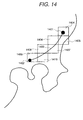
- Fig. 14 is an explanatory diagram showing examples of a map mesh and route information for the example of the travel from Hitachi-city to a location in Tokyo described above. Priority levels assigned to road information transmitted to the terminal 1306 are explained by referring to this figure. It should be noted that, in this example, the user of the terminal 1306 is assumed to be a member having a right to receive a vector map from the server 1302.
- a route 1403 begins from a start point 1401 and terminates at an end point 1402. Even though details are not shown in the figure, the route is assumed to be a portion of the Joban expressway.
- the server 1302 After calculation of a route has been finished, the server 1302 selects roads, information on which is to be transmitted to the terminal 1306, from map meshes 1404 to 1410.
- a route in the map mesh 1404 closest to the start point 1401 is extracted.
- the amount of the route data is examined and compared with the size of the memory transmitted by the terminal 1306. If the former is smaller than the latter, a route in the map mesh 1405 is also extracted. Thereafter, routes leading to the map mesh 1410 are extracted one after another as long as the total amount of route data does not exceed the size of the memory employed in the terminal 1306.
- the extraction of routes is discontinued before the total amount of route data exceeds the size of the memory. Timing to discontinue the extraction of routes is determined typically to correspond to a threshold value which is set typically at 80% of the size of the memory received from the terminal 1306.
- national roads from the map mesh 1404 to the map mesh 1410 are also extracted one after another. Timing to discontinue the extraction of national roads is determined typically to correspond to 80% of the size of the memory received from the terminal 1306 as is the case with the route extraction described above.
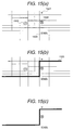
- Figs. 15A to 15C are explanatory diagrams showing an example of extraction with route data taking precedence.
- FIG. 15A is an explanatory diagram showing typical map data stored in the server 1302.
- the map data includes a post office 1501, a police office 1502, a prefectural office 1503 and a school 1504.
- Fig. 15B is an explanatory diagram showing a typical display of a map and a route 1505 obtained as a result of route computation carried out by the server 1302.
- Fig. 15C is an explanatory diagram showing typical data transmitted to the terminal 1306 for the route 1505 shown in Fig. 15B.
- the data includes the post office 1501, the police office 1502, the school 1504 and the route 1505. Not located on the route 1505, the prefectural office 1503 is not included in the transmitted data.
- the processing described above can be carried out to download data to the terminal 1306 prior to departure.
- the memory may not be capable of accommodating all the data.
- the remaining data can be downloaded during the travel along the route by erasing data of routes already traveled by the vehicle 1305 so far.
- the processing described above is carried out by using the present position of the vehicle 1305 as a start point 1401.
- the server 1302 can also be configured to adjust the technique of providing map data by not only taking the size of the memory employed in the terminal 1306 into consideration, but also utilizing information on resources of other types available in the terminal 1306.
- Information on resources of types other than the memory is transmitted by the terminal 1306 to the server 1302 as information on the terminal 1306. Examples of information on the terminal 1306 are a communication rate and a display type.
- the information on the terminal 1306 is used in the server 1302 directly or indirectly to determine timing to transmit map data.
- map data is transmitted by the server 1302 to the terminal 1306 by taking the transmission time into consideration. That is to say, data which can be transmitted within a period of time is prepared before being transmitted to the terminal 1306.
- the communication rate is 9600 bps and the time to reception of data by the terminal 1306 is 30 seconds.
- the amount of data that can be transmitted within the 30-second period of time is 36 KB.
- data with an amount of 36 KB is prepared before being transmitted to the terminal 1306. During the preparation, the priority order described above is followed.
- the terminal 1306 must make a request for a map to the server 1302 at least 30 seconds before the map is actually required.
- a location to make such a request can be found as a location preceding a place requiring the map by a distance which can be found from the communication rate and the speed of the vehicle 1306.
- a time it takes to arrive at the interchange can be calculated from the speed of the vehicle 1305 and, at the same time, the size of a free area available in the memory of the terminal 1306 is examined.
- timing to request a map can be determined from 3 parameters, namely, the speed of the vehicle 1306, the size of the memory and the communication rate. Assume that the speed of the vehicle 1306 is 100 km/h, the size of the memory is 80 KB and the communication rate is 9600 bps. Since the time it takes to receive data with an amount of 80 KB is about 66.7 seconds, the reception of data must be started before the vehicle 1305 arrives at a location preceding the interchange by at least 1.85 km. In actuality, however, the transmitted data will not occupy all the free area of the memory. Thus, since the amount of data can be assumed to be smaller than 80 KB, the location to start the reception of the data can be closer to the interchange than the calculated distance of 1.85 km.
- Fig. 18 is an explanatory diagram showing a configuration and an outline of the operation of the search engine 403 in the configuration.
- a destination named "Oomika” is entered to a place-name input field on a destination setting screen 700.
- This literal input is used as a search keyword supplied to the search engine 403.
- the search engine 403 searches the place-name word dictionary 412 for candidate place names matching the search keyword and displays the candidate place names on a screen 1801. If a plurality of candidate place names for the literal input "Oomika" exist as shown in the figure, the user enters a selected candidate place name to the search engine 403. In this example, the user enters "1" to confirm that the first candidate first name is the correct one.
- the search engine 403 searches the map data base 405 for map data matching the latitude and the longitude of the selected place name, displaying the map as a map 1802 of the destination.
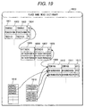
- Fig. 19 is an explanatory diagram showing the structure of the word dictionary 1803 of place names.
- place names are organized into an hierarchical structure typically comprising an urban/rural prefectural layer 1901, a city layer 1905 and a town/village layer 1909.
- Each of the hierarchical layers 1901, 1905 and 1909 comprises a phonetic transcription column (corresponding to literal inputs), a spelling column and a map information column.
- the urban/rural prefectural hierarchical layer 1901 comprises a phonetic transcription column 1902, a spelling column 1903 and a map information column 1904.
- the city hierarchical layer 1905 comprises a phonetic transcription column 1906, a spelling column 1907 and a map information column 1908.
- the town/village hierarchical layer 1909 comprises a phonetic transcription column 1910, a spelling column 1911 and a map information column 1912.
- Any town/village hierarchical layer 1909 is linked to a city row at the city hierarchical layer 1905.
- any city hierarchical layer 1905 is linked to a prefectural row at the urban/rural prefectural hierarchical layer 1901.
- any table of long-distance telephone-number prefixes 1918 and any table of zip codes 1919 are linked to a town/village row at the town/village hierarchical layer 1909.
- a destination can be found by using a long-distance prefix of a telephone number or a zip code of the destination entered by the user in place of a place name as an index.
- Fig. 20 is an explanatory diagram showing operations carried out by the search engine 403 to search the word dictionary of place names for candidates for the place name of a destination.
- the operations are exemplified by a word dictionary 2003 of addresses and a character transition table 2002.
- the address word dictionary 2003 is also organized into a hierarchical structure typically comprising an urban/rural prefectural layer, a city layer and a town/village layer.
- Each item at each of the hierarchical layers comprises an item number, an upper-layer-item number and the spelling of the item (string of characters).
- An access to an item is made by specifying the item number of the item.
- a character transition table 2002 is a table of 2-character transitions. Associated with pointers each pointing to an item at the town/village hierarchical layer in the place-name word dictionary 2003, each of the character transitions represents a transition (an index) from a character to another in a string of characters in a lateral input.
- the item A11 linked to an item A1 at the city hierarchical layer which is linked to an item A at the urban/rural prefectural hierarchical layer indicates a candidate place name of "Oomikacho, Hitachi-city, Ibaraki Prefecture".
- the item A12 also linked to an item A1 at the city hierarchical layer which is linked to an item A at the urban/rural prefectural hierarchical layer indicates a candidate place name of "Mikanoharacho, Hitachi-city, Ibaraki Prefecture".
- the item B11 linked to an item B1 at the city hierarchical layer which is linked to an item B at the urban/rural prefectural hierarchical layer indicates a candidate place name of "Oomika, Haranomachi-city, Fukushima Prefecture".
- a correct candidate can be selected with ease. It is needless to say that, in order to reduce the number of candidate name places, a candidate name place with a number of characters matching the search keyword smaller than a threshold value can be omitted from the list.
- "Mikanoharacho, Hitachi-city, Ibaraki Prefecture" has fewest characters matching the search keyword, being eliminated from the list of candidate place names. As a result, only 2 candidate place names are left on a screen 1803.
- Fig. 21 is an explanatory diagram showing processing to cut a portion of a map out off the map or, to be more specific, processing to cut a predetermined area out off a complete map or a plurality of block maps.
- This processing is referred to hereafter as clip processing.
- a map is controlled in units each comprising a plurality of blocks. If a portion of a block including a place of interest is cut out, however, an adjacent block needs to be cut out as well.
- a map of a predetermined area centered at the destination is desired.
- An example of such an area is an area centered at a location 2102. In the figure, the area has a vertical dimension 2103 and a horizontal dimension 2104.
- the whole map 1802 can be clipped.
- a line of linked vectors is also displayed as indicated by reference numeral 2105.
- the communication cost can be reduced.
- this problem can be avoided by computing the coordinates of the protruding vector and changing the start and end points.
- Fig. 22 is a flowchart representing detailed processing carried out by the server 1302 at the step 218 of the flowchart shown in Fig. 2 to search a data base for a destination.
- the flowchart begins with a step 2201 at which the literal input of a destination is received from the terminal 1306.
- the character transition table 2002 is searched for pointers pointing to the place names of the destinations matching the literal input.
- the place-name word dictionary 2003 is searched for candidate place names pointed to by the pointers and the candidate place names are sorted.
- the sorted candidate place names are transmitted to the terminal 1306.
- a place name selected by the user is received from the terminal 1306 and confirmed as the name of the destination.
- a map area in a predetermined range indicated by the latitude and longitude of the destination is clipped.
- the clipped map is transmitted to the terminal 1306.
- Fig. 23 is other typical operations carried out by the user to enter the name of a place.
- the lateral input in this example 700 shown in this figure is "Oomikahitachi” with an order of characters opposite to the correct spelling "Hitachioomika” stored in the name-place word dictionary.
- the operation to search the data base for the correct name place can be carried out. This is because the present invention uses information on a transition from one character to another. After candidate name places are sorted on the basis of the number of characters matching the lateral input, only 1 candidate is found.
- the correct place name can be found by carrying out a similar search operation even when "Oomikamura” including an excessive string of characters "mura” is entered as a lateral input.
- the correct place name can be found by carrying out a similar search operation even if "Oomiga” with a wrong character "ga” is entered as a lateral input.
- a 2-character transition table (index) is searched to find a pointer pointing to a correct place name as described above. It should be noted that a 1-character transition table or a 3-character transition table can also be used to give the same effect.
- the terminal 1306 is connected to the server 1302 when necessary. If the communication charge is assumed to be computed in accordance with the communication time, the system adopted in the embodiments incurs a lower communication cost. If the communication charge is assumed to be computed in accordance with the amount of data communicated, however, it is not necessarily good to cut off the communication. In this case, services different from those described above can be rendered.
- the terminal 1306 downloads information on routes and a judgment on the location to download the information is also formed by the terminal 1306.
- the terminal 1306 transmits vehicle-position information, the vehicle speed and terminal information to the server 1302 at fixed time intervals to be used by the server 1302 to form a judgment as to whether or not to download a map.
- the terminal 1306 transmits vehicle-position information, the vehicle speed and terminal information to the server 1302 at fixed distances instead of fixed time intervals.
- the server 1302 properly determines a location to download map data under a condition determined in advance.
- the server 1302 gives the terminal 1306 a warning when the vehicle 1305 slips off from the route and is capable of avoiding downloading at a location such as a tunnel where it is impossible or difficult to carry out stable communication. As a result, it is possible to render services of providing information with a high degree of efficiency and a high degree of reliability.
- the information providing system can have a configuration wherein 1 server 1302 controls a plurality of terminals 1306 or vehicles 1305 individually, providing them with requested information.
- the server 1302 connected to the Internet 1302 is capable of serving a plurality of terminals 1306.
- the embodiments described above each have a configuration in which a terminal 1306 makes a telephone call to the server 1302 to download map data.
- the server 1302 can also make a telephone call to a terminal 1306 to transmit a map.
- a route for example, not only is a map display location or a location to download map data found, but a time at which the vehicle 1305 is expected to pass through the location can also be estimated.
- the server 1302 makes a telephone call to the terminal 1306, transmitting a map of the vicinity of the map display location to be passed through at the estimated time when the estimated time is nearing.
- the present invention provides a terminal 1306 which is mounted on a vehicle 1305 and used for providing a route guide showing directions leading to a destination. It should be noted that the present invention can also be applied to portable and home terminals with the same configuration. That is to say, the same configuration can be adopted as long as a map can be downloaded through a communication line.
- a means which allows the user to download a map whenever needed from a server on a network by merely entering a portion of the lateral name of a destination.
- a terminal for receiving map data is capable of receiving a service to provide minimum map data necessary for navigation even if the size of the memory resource in the terminal is small.
Applications Claiming Priority (4)
| Application Number | Priority Date | Filing Date | Title |
|---|---|---|---|
| JP5865399A JP4084901B2 (ja) | 1999-03-05 | 1999-03-05 | 情報提供システム |
| JP5865399 | 1999-03-05 | ||
| JP18107299 | 1999-06-28 | ||
| JP11181072A JP2001012960A (ja) | 1999-06-28 | 1999-06-28 | 情報提供システム |
Publications (3)
| Publication Number | Publication Date |
|---|---|
| EP1035531A2 true EP1035531A2 (fr) | 2000-09-13 |
| EP1035531A3 EP1035531A3 (fr) | 2000-11-22 |
| EP1035531B1 EP1035531B1 (fr) | 2006-04-26 |
Family
ID=26399682
Family Applications (1)
| Application Number | Title | Priority Date | Filing Date |
|---|---|---|---|
| EP00103452A Expired - Lifetime EP1035531B1 (fr) | 1999-03-05 | 2000-02-29 | Système fournissant de l'information pour unités mobiles |
Country Status (4)
| Country | Link |
|---|---|
| US (1) | US6324467B1 (fr) |
| EP (1) | EP1035531B1 (fr) |
| KR (1) | KR100711688B1 (fr) |
| DE (1) | DE60027499T2 (fr) |
Cited By (23)
| Publication number | Priority date | Publication date | Assignee | Title |
|---|---|---|---|---|
| EP1221588A1 (fr) | 2001-01-03 | 2002-07-10 | Motorola, Inc. | Méthode de navigation |
| DE10101653C1 (de) * | 2001-01-16 | 2002-07-25 | Tegaron Telematics Gmbh | Verfahren zur Informationsabfrage aus einer Dienstezentrale |
| WO2002065429A1 (fr) * | 2001-02-09 | 2002-08-22 | Robert Bosch Gmbh | Procede pour ajuster la position d'un vehicule terrestre |
| EP1253571A2 (fr) | 2001-04-27 | 2002-10-30 | Pioneer Corporation | Terminal de navigation et procédé de navigation |
| EP1274059A1 (fr) * | 2001-07-04 | 2003-01-08 | Nissan Motor Company, Limited | Système de navigation pour un véhicule |
| EP1338865A1 (fr) * | 2002-02-19 | 2003-08-27 | Hitachi, Ltd. | Système de navigation |
| WO2003077222A1 (fr) * | 2002-03-09 | 2003-09-18 | Robert Bosch Gmbh | Procede et systeme de guidage automatique de vehicule |
| EP1347427A2 (fr) * | 2002-03-20 | 2003-09-24 | Vehicle Information and Communication System Center | Emetteur, procédé et logiciel pour transmettre des informations de circulation routière, et recepteur, procédé et logiciel pour recevoir des informations de circulation routière |
| EP1406065A2 (fr) * | 2002-10-04 | 2004-04-07 | Pioneer Corporation | Support d'enregistrement enregistrant de l'imformation hiérarchique, dispositif, système, procédé et logiciel pour récupération d'information, et support d'enregistrement enregistrant un tel logiciel |
| AU773783B2 (en) * | 2001-10-31 | 2004-06-03 | E-Lead Electronic Co., Ltd | Remote-end route-calculating navigation system |
| EP1469284A1 (fr) * | 2003-04-18 | 2004-10-20 | Aisin Aw Co., Ltd. | Système de traitement d'information avec identification |
| EP1500948A1 (fr) * | 2003-07-22 | 2005-01-26 | Microsoft Corporation | Utilisation de la position approximative d'un dispositif déterminé à partir des signaux ambiants |
| EP1525432A1 (fr) * | 2002-06-25 | 2005-04-27 | Motorola, Inc., A Corporation of the State of Delaware; | Systeme de navigation a base de serveurs et a transmission dynamique des informations de route |
| EP1550989A2 (fr) * | 2003-12-31 | 2005-07-06 | Samsung Electronics Co., Ltd. | Terminal télématique et procédé pour transmettre données d'information de guidage routier |
| WO2007115614A1 (fr) * | 2006-03-31 | 2007-10-18 | Volkswagen Aktiengesellschaft | Système de navigation et procédé de navigation destinés à un véhicule à moteur |
| US7319877B2 (en) | 2003-07-22 | 2008-01-15 | Microsoft Corporation | Methods for determining the approximate location of a device from ambient signals |
| DE10204490B4 (de) * | 2001-04-06 | 2010-04-15 | Mitsubishi Denki K.K. | Navigationssystem für Fahrzeuge |
| US7738881B2 (en) | 2003-07-22 | 2010-06-15 | Microsoft Corporation | Systems for determining the approximate location of a device from ambient signals |
| US8554463B2 (en) | 2006-03-31 | 2013-10-08 | Volkswagen Ag | Navigation system for a motor vehicle |
| US8700308B2 (en) | 2006-03-31 | 2014-04-15 | Volkswagen Ag | Navigation system for a motor vehicle |
| US9052214B2 (en) | 2006-05-22 | 2015-06-09 | Volkswagen Ag | Navigation system for a motor vehicle, method for operating a navigation system and motor vehicle including a navigation system |
| US9478133B2 (en) | 2006-03-31 | 2016-10-25 | Volkswagen Ag | Motor vehicle and navigation arrangement for a motor vehicle |
| WO2020104087A1 (fr) * | 2018-11-21 | 2020-05-28 | Robert Bosch Gmbh | Procédé de réalisation d'une planification temporelle pour la transmission de données |
Families Citing this family (94)
| Publication number | Priority date | Publication date | Assignee | Title |
|---|---|---|---|---|
| US20040215387A1 (en) | 2002-02-14 | 2004-10-28 | Matsushita Electric Industrial Co., Ltd. | Method for transmitting location information on a digital map, apparatus for implementing the method, and traffic information provision/reception system |
| JP3481168B2 (ja) | 1999-08-27 | 2003-12-22 | 松下電器産業株式会社 | デジタル地図の位置情報伝達方法 |
| US6671757B1 (en) | 2000-01-26 | 2003-12-30 | Fusionone, Inc. | Data transfer and synchronization system |
| US8156074B1 (en) | 2000-01-26 | 2012-04-10 | Synchronoss Technologies, Inc. | Data transfer and synchronization system |
| US8620286B2 (en) | 2004-02-27 | 2013-12-31 | Synchronoss Technologies, Inc. | Method and system for promoting and transferring licensed content and applications |
| JP2001221643A (ja) * | 2000-02-04 | 2001-08-17 | Pioneer Electronic Corp | カーナビゲーションシステムからの地図情報切り出し装置 |
| KR20000030683A (ko) * | 2000-03-11 | 2000-06-05 | 남기효 | 사용자 주문형 약도자동생성 및 약도검색 시스템과 그제어방법 |
| JP3816299B2 (ja) * | 2000-04-28 | 2006-08-30 | パイオニア株式会社 | ナビゲーションシステム |
| DE10023530A1 (de) * | 2000-05-13 | 2001-11-15 | Mannesmann Vdo Ag | Zielführungsanzeige für Navigationssysteme |
| US8073954B1 (en) | 2000-07-19 | 2011-12-06 | Synchronoss Technologies, Inc. | Method and apparatus for a secure remote access system |
| US7895334B1 (en) | 2000-07-19 | 2011-02-22 | Fusionone, Inc. | Remote access communication architecture apparatus and method |
| JP2002048566A (ja) * | 2000-08-04 | 2002-02-15 | Mazda Motor Corp | 地図情報等配信システム、地図情報等供給装置、移動体用ナビゲーション装置、及び、ナビゲーションプログラムを記録した記録媒体 |
| CN1308875C (zh) * | 2000-08-07 | 2007-04-04 | 夏普公司 | 用于根据终端位置信息处理信息的服务器装置 |
| JP4490566B2 (ja) * | 2000-09-13 | 2010-06-30 | 株式会社日立製作所 | 端末装置およびナビゲーションサーバ |
| US6703947B1 (en) * | 2000-09-22 | 2004-03-09 | Tierravision, Inc. | Method for organizing and compressing spatial data |
| JP3929894B2 (ja) * | 2000-10-11 | 2007-06-13 | 三菱電機株式会社 | 位置関連情報仲介・獲得方法、仲介コンピュータシステム、及び移動端末 |
| JP4821039B2 (ja) * | 2000-10-24 | 2011-11-24 | 日本電気株式会社 | 地名情報抽出装置、その抽出方法及び記録媒体 |
| US6895329B1 (en) * | 2000-10-30 | 2005-05-17 | Board Of Trustees Of The University Of Illinois | Method and system for querying in a moving object database |
| JP5041638B2 (ja) * | 2000-12-08 | 2012-10-03 | パナソニック株式会社 | デジタル地図の位置情報伝達方法とそれに使用する装置 |
| US7818435B1 (en) | 2000-12-14 | 2010-10-19 | Fusionone, Inc. | Reverse proxy mechanism for retrieving electronic content associated with a local network |
| DE10065382A1 (de) * | 2000-12-27 | 2002-07-18 | Nokia Mobile Phones Ltd | Navigationssystem und Verfahren zur Zielführung von Benutzern, insbesondere von Fahrern von Fahrzeugen |
| JP4663136B2 (ja) | 2001-01-29 | 2011-03-30 | パナソニック株式会社 | デジタル地図の位置情報伝達方法と装置 |
| JP2002229991A (ja) * | 2001-01-31 | 2002-08-16 | Fujitsu Ltd | サーバ,ユーザ端末,情報提供サービスシステムおよび情報提供サービス方法 |
| JP2002318844A (ja) * | 2001-02-15 | 2002-10-31 | Hitachi Ltd | 車両管理方法 |
| US6718176B2 (en) * | 2001-03-01 | 2004-04-06 | Nokia Corporation | Apparatus, and associated method, for displaying positional data associated with mobile stations of a radio communication system |
| JP2002259277A (ja) * | 2001-03-02 | 2002-09-13 | Toshiba Tec Corp | 画像形成システム及び画像形成装置 |
| US20020128768A1 (en) * | 2001-03-09 | 2002-09-12 | Nobuyuki Nakano | Route guide information distributing system |
| US8615566B1 (en) | 2001-03-23 | 2013-12-24 | Synchronoss Technologies, Inc. | Apparatus and method for operational support of remote network systems |
| US6980905B2 (en) * | 2001-04-12 | 2005-12-27 | Elead Electronics Co., Ltd. | Remote-end route-calculating navigation system |
| US6842695B1 (en) * | 2001-04-17 | 2005-01-11 | Fusionone, Inc. | Mapping and addressing system for a secure remote access system |
| US6691128B2 (en) * | 2001-04-19 | 2004-02-10 | Navigation Technologies Corp. | Navigation system with distributed computing architecture |
| JP4391037B2 (ja) * | 2001-04-27 | 2009-12-24 | パイオニア株式会社 | ナビゲーション装置、ナビゲーション方法、及びナビゲーションプログラム |
| JP4688198B2 (ja) * | 2001-07-31 | 2011-05-25 | パイオニア株式会社 | 地図情報表示システム、地図情報表示方法、サーバ装置および端末装置 |
| JP2003042772A (ja) | 2001-07-31 | 2003-02-13 | Pioneer Electronic Corp | 通信ナビゲーションシステム、通信ナビゲーション方法、経路誘導情報送信装置および端末装置 |
| JP2003042790A (ja) | 2001-08-01 | 2003-02-13 | Pioneer Electronic Corp | 通信ナビゲーションシステム、通信ナビゲーション方法、端末装置および経路誘導情報送信装置 |
| JP2003065783A (ja) | 2001-08-27 | 2003-03-05 | Pioneer Electronic Corp | 通信ナビゲーションシステム及び方法、地図情報提供通信センタ装置、通信ナビゲーション端末並びにコンピュータプログラム |
| EP1288625B1 (fr) * | 2001-08-31 | 2011-07-27 | Pioneer Corporation | Appareil de navigation de type communication et serveur |
| JP2003156340A (ja) * | 2001-09-10 | 2003-05-30 | Pioneer Electronic Corp | ナビゲーションシステム、ナビゲーションシステム用情報サーバ装置および通信端末装置、並びに、ナビゲーションシステムにおける移動体の変更方法および変更処理プログラム |
| US6658348B2 (en) * | 2001-10-09 | 2003-12-02 | Hewlett-Packard Development Company, L.P. | Systems and methods for providing information to users |
| US6975940B1 (en) * | 2001-12-21 | 2005-12-13 | Garmin Ltd. | Systems, functional data, and methods for generating a route |
| EP1473542A4 (fr) * | 2002-02-07 | 2010-01-06 | Sanyo Electric Co | Systeme de navigation, dispositif de navigation et dispositif serveur |
| US6873905B2 (en) * | 2002-03-19 | 2005-03-29 | Opnext Japan, Inc. | Communications type navigation device |
| JP2003302225A (ja) * | 2002-04-10 | 2003-10-24 | Pioneer Electronic Corp | ナビゲーション装置及びそのためのプログラム |
| JP2004037664A (ja) * | 2002-07-01 | 2004-02-05 | Nec Corp | 情報端末装置 |
| JP3954454B2 (ja) * | 2002-07-05 | 2007-08-08 | アルパイン株式会社 | 地図データ配信システムおよびナビゲーション装置 |
| JP2004108802A (ja) * | 2002-09-13 | 2004-04-08 | Pioneer Electronic Corp | ナビゲーション端末、ナビゲーションシステム、そのプログラム、及び情報送信方法 |
| JP2004212056A (ja) * | 2002-12-26 | 2004-07-29 | Aisin Aw Co Ltd | ナビゲーションシステム及び経路探索方法のプログラム |
| DE10302677A1 (de) * | 2003-01-24 | 2004-07-29 | Robert Bosch Gmbh | Navigationsvorrichtung |
| JP4138561B2 (ja) * | 2003-04-09 | 2008-08-27 | パイオニア株式会社 | ナビゲーション装置、ナビゲーション方法、および、経路データ生成プログラム |
| CN100383801C (zh) * | 2003-05-26 | 2008-04-23 | 辛忻 | 基于车辆检索技术的交通实时监控系统 |
| WO2005010715A2 (fr) | 2003-07-21 | 2005-02-03 | Fusionone, Inc. | Systeme de gestion de messages de dispositifs |
| JP2005106496A (ja) * | 2003-09-29 | 2005-04-21 | Aisin Aw Co Ltd | ナビゲーション装置 |
| JP2005127855A (ja) * | 2003-10-23 | 2005-05-19 | Navitime Japan Co Ltd | ナビゲーション装置、ナビゲーション方法、ナビゲーションプログラム |
| US7263438B2 (en) * | 2003-12-23 | 2007-08-28 | Honda Motor Co., Ltd. | Smart storage and transmission of navigation information |
| US7480561B2 (en) * | 2003-12-23 | 2009-01-20 | Honda Motor Co., Ltd. | Prioritized delivery of navigation information |
| WO2005095889A1 (fr) * | 2004-03-31 | 2005-10-13 | Kyocera Corporation | Dispositif d'affichage d'orientement et procede d'affichage d'orientement |
| JP4823893B2 (ja) * | 2004-03-31 | 2011-11-24 | パイオニア株式会社 | データ選択装置、データ選択方法、データ選択プログラムおよびそれを記録した記録媒体、並びに、ナビゲーション装置、ナビゲーション方法、ナビゲーションプログラムおよびそれを記録した記録媒体 |
| US7206696B2 (en) * | 2004-05-19 | 2007-04-17 | Honda Motor Co., Ltd. | Method for modifying navigation information |
| US9542076B1 (en) | 2004-05-12 | 2017-01-10 | Synchronoss Technologies, Inc. | System for and method of updating a personal profile |
| CN1998224A (zh) | 2004-05-12 | 2007-07-11 | 富盛旺公司 | 高级联络识别系统 |
| US20050261829A1 (en) * | 2004-05-19 | 2005-11-24 | Honda Motor Co., Ltd. | System and method for off route processing |
| US20050261824A1 (en) * | 2004-05-19 | 2005-11-24 | Honda Motor Co., Ltd. | System and method for varying content |
| US7292936B2 (en) * | 2004-05-19 | 2007-11-06 | Honda Motor Co., Ltd. | System and method for displaying information |
| US20060058953A1 (en) | 2004-09-07 | 2006-03-16 | Cooper Clive W | System and method of wireless downloads of map and geographic based data to portable computing devices |
| US7480567B2 (en) * | 2004-09-24 | 2009-01-20 | Nokia Corporation | Displaying a map having a close known location |
| US7657368B2 (en) * | 2004-11-08 | 2010-02-02 | General Motors Company | System and method for large route data handling within a telematics communication system |
| US7236882B2 (en) * | 2005-01-26 | 2007-06-26 | Broadcom Corporation | Downloading map segment(s) to a cell phone based upon its GPS coordinates and mobility |
| US7698061B2 (en) * | 2005-09-23 | 2010-04-13 | Scenera Technologies, Llc | System and method for selecting and presenting a route to a user |
| US7925320B2 (en) | 2006-03-06 | 2011-04-12 | Garmin Switzerland Gmbh | Electronic device mount |
| US7702456B2 (en) * | 2006-04-14 | 2010-04-20 | Scenera Technologies, Llc | System and method for presenting a computed route |
| US7684017B2 (en) | 2006-10-26 | 2010-03-23 | Callaway Golf Company | Laser range finder for use on a golf course |
| JP4725535B2 (ja) * | 2007-02-27 | 2011-07-13 | アイシン・エィ・ダブリュ株式会社 | 地図情報更新システム |
| JP4850133B2 (ja) * | 2007-06-06 | 2012-01-11 | アルパイン株式会社 | 地図表示装置及び地図表示方法 |
| JP4345897B2 (ja) * | 2007-07-05 | 2009-10-14 | 本田技研工業株式会社 | ナビ装置、ナビシステム |
| US8181111B1 (en) | 2007-12-31 | 2012-05-15 | Synchronoss Technologies, Inc. | System and method for providing social context to digital activity |
| US8792916B2 (en) * | 2008-01-14 | 2014-07-29 | Blackberry Limited | Dynamic prioritization of label downloads |
| US9354068B2 (en) | 2008-01-14 | 2016-05-31 | Blackberry Limited | System and method for dynamically downloading and displaying map data |
| EP2078926B1 (fr) | 2008-01-14 | 2013-10-16 | BlackBerry Limited | Système et procédé de téléchargement dynamique et affichage de données cartographiques |
| JP2009230261A (ja) * | 2008-03-19 | 2009-10-08 | Kenwood Corp | 配信システム及び車載器 |
| KR101062664B1 (ko) * | 2008-04-08 | 2011-09-06 | 팅크웨어(주) | 선형 지도 데이터의 주기 표시방법 및 그 장치 |
| US20120047087A1 (en) | 2009-03-25 | 2012-02-23 | Waldeck Technology Llc | Smart encounters |
| US8255006B1 (en) | 2009-11-10 | 2012-08-28 | Fusionone, Inc. | Event dependent notification system and method |
| US8819672B2 (en) * | 2010-09-20 | 2014-08-26 | International Business Machines Corporation | Multi-image migration system and method |
| US8943428B2 (en) | 2010-11-01 | 2015-01-27 | Synchronoss Technologies, Inc. | System for and method of field mapping |
| US9267806B2 (en) * | 2011-08-29 | 2016-02-23 | Bayerische Motoren Werke Aktiengesellschaft | System and method for automatically receiving geo-relevant information in a vehicle |
| CN103036918A (zh) * | 2011-09-30 | 2013-04-10 | 深圳市喜赛科技有限公司 | 跟踪系统、跟踪服务器及跟踪器 |
| WO2013094865A1 (fr) * | 2011-12-18 | 2013-06-27 | 엘지전자 주식회사 | Procédé de calcul de trajets, procédé d'obtention de trajets ainsi que terminal pour celui-ci |
| IN2014DN08343A (fr) * | 2012-03-16 | 2015-05-08 | Qoros Automotive Co Ltd | |
| US8761989B1 (en) * | 2012-12-18 | 2014-06-24 | Jervis B. Webb Company | Method of material handling with automatic guided vehicles |
| JP6446784B2 (ja) * | 2014-01-21 | 2019-01-09 | 株式会社デンソー | ナビゲーション装置 |
| US9643615B2 (en) * | 2014-06-04 | 2017-05-09 | International Business Machines Corporation | Automotive dynamic virtual network |
| US9992628B2 (en) * | 2016-04-21 | 2018-06-05 | Microsoft Technology Licensing, Llc | Map downloading based on user's future location |
| CN109643489B (zh) | 2016-08-26 | 2022-05-03 | 松下电器(美国)知识产权公司 | 三维信息处理方法以及三维信息处理装置 |
| CN111854768B (zh) * | 2020-03-05 | 2022-05-24 | 北京嘀嘀无限科技发展有限公司 | 地图路线的确定方法和系统、终端和计算机可读存储介质 |
Citations (8)
| Publication number | Priority date | Publication date | Assignee | Title |
|---|---|---|---|---|
| EP0538059A2 (fr) * | 1991-10-17 | 1993-04-21 | Ricoh Company, Ltd | Système et procédé pour le traitement de documents |
| US5450343A (en) * | 1992-10-28 | 1995-09-12 | Matsushita Electric Industrial Co., Ltd. | Vehicle-navigation device |
| DE19544921A1 (de) * | 1994-12-02 | 1996-07-04 | Nissan Motor | Apparat und Verfahren für navigierende mobile Körper, die eine aus der Vogelperspektive angezeigte Straßenkart benutzen |
| US5543789A (en) * | 1994-06-24 | 1996-08-06 | Shields Enterprises, Inc. | Computerized navigation system |
| EP0785535A1 (fr) * | 1996-01-16 | 1997-07-23 | Mitsubishi Denki Kabushiki Kaisha | Système de guidage intégré pour véhicule |
| US5699255A (en) * | 1995-10-18 | 1997-12-16 | Trimble Navigation Limited | Map transmission for in-vehicle navigation system with dynamic scale/detail adjustment |
| EP0822530A1 (fr) * | 1996-07-31 | 1998-02-04 | Aisin Aw Co., Ltd. | Système de navigation pour automobile et son support de mémoire |
| DE19832035A1 (de) * | 1997-07-17 | 1999-02-18 | Toyota Motor Co Ltd | Kartendatenverteilungssystem und Kartendatenbeschaffungseinrichtung für das System |
Family Cites Families (8)
| Publication number | Priority date | Publication date | Assignee | Title |
|---|---|---|---|---|
| SU987812A1 (ru) * | 1981-07-30 | 1983-01-07 | Предприятие П/Я В-2749 | Дешифратор врем -импульсных кодов |
| JPH08285613A (ja) * | 1995-04-19 | 1996-11-01 | Nippon Telegr & Teleph Corp <Ntt> | 情報集中管理型ナビゲーションシステム |
| JPH09166450A (ja) * | 1995-12-18 | 1997-06-24 | Sumitomo Electric Ind Ltd | ナビゲーション装置 |
| US5928306A (en) * | 1996-08-22 | 1999-07-27 | Trimble Navigation Limited | Method and apparatus for automated differential GPS processing |
| KR100269070B1 (ko) * | 1996-08-30 | 2000-10-16 | 모리 하루오 | 차량용네비게이션장치 |
| JP3546659B2 (ja) * | 1997-09-25 | 2004-07-28 | トヨタ自動車株式会社 | 車両用データ処理システム、そのシステムを構成する車載端末装置およびナビゲーション装置 |
| US6249740B1 (en) * | 1998-01-21 | 2001-06-19 | Kabushikikaisha Equos Research | Communications navigation system, and navigation base apparatus and vehicle navigation apparatus both used in the navigation system |
| US6202024B1 (en) * | 1998-03-23 | 2001-03-13 | Kabushikikaisha Equos Research | Communicatory navigation system |
-
2000
- 2000-02-29 DE DE60027499T patent/DE60027499T2/de not_active Expired - Lifetime
- 2000-02-29 EP EP00103452A patent/EP1035531B1/fr not_active Expired - Lifetime
- 2000-03-03 US US09/518,908 patent/US6324467B1/en not_active Expired - Fee Related
- 2000-03-04 KR KR1020000010903A patent/KR100711688B1/ko not_active IP Right Cessation
Patent Citations (8)
| Publication number | Priority date | Publication date | Assignee | Title |
|---|---|---|---|---|
| EP0538059A2 (fr) * | 1991-10-17 | 1993-04-21 | Ricoh Company, Ltd | Système et procédé pour le traitement de documents |
| US5450343A (en) * | 1992-10-28 | 1995-09-12 | Matsushita Electric Industrial Co., Ltd. | Vehicle-navigation device |
| US5543789A (en) * | 1994-06-24 | 1996-08-06 | Shields Enterprises, Inc. | Computerized navigation system |
| DE19544921A1 (de) * | 1994-12-02 | 1996-07-04 | Nissan Motor | Apparat und Verfahren für navigierende mobile Körper, die eine aus der Vogelperspektive angezeigte Straßenkart benutzen |
| US5699255A (en) * | 1995-10-18 | 1997-12-16 | Trimble Navigation Limited | Map transmission for in-vehicle navigation system with dynamic scale/detail adjustment |
| EP0785535A1 (fr) * | 1996-01-16 | 1997-07-23 | Mitsubishi Denki Kabushiki Kaisha | Système de guidage intégré pour véhicule |
| EP0822530A1 (fr) * | 1996-07-31 | 1998-02-04 | Aisin Aw Co., Ltd. | Système de navigation pour automobile et son support de mémoire |
| DE19832035A1 (de) * | 1997-07-17 | 1999-02-18 | Toyota Motor Co Ltd | Kartendatenverteilungssystem und Kartendatenbeschaffungseinrichtung für das System |
Cited By (38)
| Publication number | Priority date | Publication date | Assignee | Title |
|---|---|---|---|---|
| EP1221588A1 (fr) | 2001-01-03 | 2002-07-10 | Motorola, Inc. | Méthode de navigation |
| EP2341315A1 (fr) * | 2001-01-03 | 2011-07-06 | Motorola Mobility, Inc. | Méthode de navigation |
| DE10101653C1 (de) * | 2001-01-16 | 2002-07-25 | Tegaron Telematics Gmbh | Verfahren zur Informationsabfrage aus einer Dienstezentrale |
| WO2002065429A1 (fr) * | 2001-02-09 | 2002-08-22 | Robert Bosch Gmbh | Procede pour ajuster la position d'un vehicule terrestre |
| DE10204490B4 (de) * | 2001-04-06 | 2010-04-15 | Mitsubishi Denki K.K. | Navigationssystem für Fahrzeuge |
| EP1253571A3 (fr) * | 2001-04-27 | 2007-09-19 | Pioneer Corporation | Terminal de navigation et procédé de navigation |
| EP1253571A2 (fr) | 2001-04-27 | 2002-10-30 | Pioneer Corporation | Terminal de navigation et procédé de navigation |
| US6629035B2 (en) | 2001-07-04 | 2003-09-30 | Nissan Motor Co., Ltd. | Navigation system for vehicle |
| EP1274059A1 (fr) * | 2001-07-04 | 2003-01-08 | Nissan Motor Company, Limited | Système de navigation pour un véhicule |
| AU773783B2 (en) * | 2001-10-31 | 2004-06-03 | E-Lead Electronic Co., Ltd | Remote-end route-calculating navigation system |
| EP1338865A1 (fr) * | 2002-02-19 | 2003-08-27 | Hitachi, Ltd. | Système de navigation |
| US7317973B2 (en) | 2002-03-09 | 2008-01-08 | Robert Bosch Gmbh | Automatic vehicle guidance method and system |
| WO2003077222A1 (fr) * | 2002-03-09 | 2003-09-18 | Robert Bosch Gmbh | Procede et systeme de guidage automatique de vehicule |
| EP1347427A3 (fr) * | 2002-03-20 | 2003-11-19 | Vehicle Information and Communication System Center | Emetteur, procédé et logiciel pour transmettre des informations de circulation routière, et recepteur, procédé et logiciel pour recevoir des informations de circulation routière |
| EP1347427A2 (fr) * | 2002-03-20 | 2003-09-24 | Vehicle Information and Communication System Center | Emetteur, procédé et logiciel pour transmettre des informations de circulation routière, et recepteur, procédé et logiciel pour recevoir des informations de circulation routière |
| EP1525432A4 (fr) * | 2002-06-25 | 2007-05-09 | Motorola Inc | Systeme de navigation a base de serveurs et a transmission dynamique des informations de route |
| EP1525432A1 (fr) * | 2002-06-25 | 2005-04-27 | Motorola, Inc., A Corporation of the State of Delaware; | Systeme de navigation a base de serveurs et a transmission dynamique des informations de route |
| EP1406065A2 (fr) * | 2002-10-04 | 2004-04-07 | Pioneer Corporation | Support d'enregistrement enregistrant de l'imformation hiérarchique, dispositif, système, procédé et logiciel pour récupération d'information, et support d'enregistrement enregistrant un tel logiciel |
| EP1406065A3 (fr) * | 2002-10-04 | 2005-05-11 | Pioneer Corporation | Support d'enregistrement enregistrant de l'imformation hiérarchique, dispositif, système, procédé et logiciel pour récupération d'information, et support d'enregistrement enregistrant un tel logiciel |
| EP1469284A1 (fr) * | 2003-04-18 | 2004-10-20 | Aisin Aw Co., Ltd. | Système de traitement d'information avec identification |
| US7202816B2 (en) | 2003-07-22 | 2007-04-10 | Microsoft Corporation | Utilization of the approximate location of a device determined from ambient signals |
| US7738881B2 (en) | 2003-07-22 | 2010-06-15 | Microsoft Corporation | Systems for determining the approximate location of a device from ambient signals |
| CN1607399B (zh) * | 2003-07-22 | 2011-08-17 | 微软公司 | 由环境信号确定的设备的近似位置的使用 |
| US7319877B2 (en) | 2003-07-22 | 2008-01-15 | Microsoft Corporation | Methods for determining the approximate location of a device from ambient signals |
| EP1500948A1 (fr) * | 2003-07-22 | 2005-01-26 | Microsoft Corporation | Utilisation de la position approximative d'un dispositif déterminé à partir des signaux ambiants |
| CN1607400B (zh) * | 2003-07-22 | 2010-10-13 | 微软公司 | 根据周围信号确定装置的近似位置的方法 |
| EP1550989A2 (fr) * | 2003-12-31 | 2005-07-06 | Samsung Electronics Co., Ltd. | Terminal télématique et procédé pour transmettre données d'information de guidage routier |
| US7444239B2 (en) | 2003-12-31 | 2008-10-28 | Samsung Electronics Co., Ltd. | Telematics terminal and method for transmitting route guidance information data fitted to a receiving terminal |
| EP1550989A3 (fr) * | 2003-12-31 | 2006-10-04 | Samsung Electronics Co., Ltd. | Terminal télématique et procédé pour transmettre données d'information de guidage routier |
| WO2007115614A1 (fr) * | 2006-03-31 | 2007-10-18 | Volkswagen Aktiengesellschaft | Système de navigation et procédé de navigation destinés à un véhicule à moteur |
| US8554463B2 (en) | 2006-03-31 | 2013-10-08 | Volkswagen Ag | Navigation system for a motor vehicle |
| US8700308B2 (en) | 2006-03-31 | 2014-04-15 | Volkswagen Ag | Navigation system for a motor vehicle |
| CN104634357A (zh) * | 2006-03-31 | 2015-05-20 | 大众汽车有限公司 | 用于机动车辆的导航组件和导航方法 |
| US9478133B2 (en) | 2006-03-31 | 2016-10-25 | Volkswagen Ag | Motor vehicle and navigation arrangement for a motor vehicle |
| US9846051B2 (en) | 2006-03-31 | 2017-12-19 | Volkswagen Ag | Navigation system for a motor vehicle |
| CN104634357B (zh) * | 2006-03-31 | 2020-01-03 | 大众汽车有限公司 | 用于机动车辆的导航组件和导航方法 |
| US9052214B2 (en) | 2006-05-22 | 2015-06-09 | Volkswagen Ag | Navigation system for a motor vehicle, method for operating a navigation system and motor vehicle including a navigation system |
| WO2020104087A1 (fr) * | 2018-11-21 | 2020-05-28 | Robert Bosch Gmbh | Procédé de réalisation d'une planification temporelle pour la transmission de données |
Also Published As
| Publication number | Publication date |
|---|---|
| KR100711688B1 (ko) | 2007-04-30 |
| US6324467B1 (en) | 2001-11-27 |
| DE60027499D1 (de) | 2006-06-01 |
| EP1035531B1 (fr) | 2006-04-26 |
| KR20010006738A (ko) | 2001-01-26 |
| EP1035531A3 (fr) | 2000-11-22 |
| DE60027499T2 (de) | 2006-11-16 |
Similar Documents
| Publication | Publication Date | Title |
|---|---|---|
| EP1035531B1 (fr) | Système fournissant de l'information pour unités mobiles | |
| JP4084901B2 (ja) | 情報提供システム | |
| EP1317742B1 (fr) | Systeme de navigation mettant en oeuvre un reseau de communication sans fil ainsi qu'un procede de guidage routier associe | |
| US7342516B2 (en) | Method and apparatus for communicating map and route guidance information for vehicle navigation | |
| CN101936744B (zh) | 路径引导服务器装置、导航装置、路径引导系统及方法 | |
| US7089110B2 (en) | Dynamic navigation system | |
| JP4603950B2 (ja) | ナビゲーションシステム、poi探索方法、情報配信サーバおよび携帯端末 | |
| US7650235B2 (en) | Telematics system using image data and method for directing a route by using the same | |
| US20070233384A1 (en) | Method and system for off-board navigation with a portable device | |
| EP2290321A1 (fr) | Dispositif de navigation, procédé de navigation et système de navigation | |
| US8471729B2 (en) | Road-vehicle communication system | |
| US20010037305A1 (en) | Interactive navigation system | |
| JPH1151666A (ja) | 移動通信端末向け情報検索配信装置および移動通信端末 | |
| JP2009093384A (ja) | Poi検索システム、経路探索サーバおよびpoi検索方法 | |
| JP2005164474A (ja) | 経路案内用データ作成装置および経路案内用データを用いた経路案内配信装置 | |
| JP2001012960A (ja) | 情報提供システム | |
| US11359929B2 (en) | Automatic selection of map detail levels | |
| JP2002048579A (ja) | 通信型ナビゲーションシステム | |
| WO2004084437A1 (fr) | Systeme de navigation utilisant un dispositif mobile et son procede | |
| JP4365359B2 (ja) | ナビゲーションシステム、ナビゲーション装置およびナビゲーション装置における動作モード制御方法 | |
| JP4612016B2 (ja) | ナビゲーションシステム、経路探索サーバおよび経路案内方法 | |
| JP2003222527A (ja) | 車輌誘導システム | |
| JP2008129224A (ja) | 地図表示システム、地図配信サーバおよび地図表示端末ならびに住所特定方法 | |
| JP4110320B2 (ja) | ナビゲーションシステム及びプログラム | |
| JP2824198B2 (ja) | ナビゲーション装置 |
Legal Events
| Date | Code | Title | Description |
|---|---|---|---|
| PUAI | Public reference made under article 153(3) epc to a published international application that has entered the european phase |
Free format text: ORIGINAL CODE: 0009012 |
|
| AK | Designated contracting states |
Kind code of ref document: A2 Designated state(s): DE FR GB |
|
| AX | Request for extension of the european patent |
Free format text: AL;LT;LV;MK;RO;SI |
|
| PUAL | Search report despatched |
Free format text: ORIGINAL CODE: 0009013 |
|
| AK | Designated contracting states |
Kind code of ref document: A3 Designated state(s): AT BE CH CY DE DK ES FI FR GB GR IE IT LI LU MC NL PT SE |
|
| AX | Request for extension of the european patent |
Free format text: AL;LT;LV;MK;RO;SI |
|
| 17P | Request for examination filed |
Effective date: 20010404 |
|
| AKX | Designation fees paid |
Free format text: DE FR GB |
|
| 17Q | First examination report despatched |
Effective date: 20040413 |
|
| GRAP | Despatch of communication of intention to grant a patent |
Free format text: ORIGINAL CODE: EPIDOSNIGR1 |
|
| GRAS | Grant fee paid |
Free format text: ORIGINAL CODE: EPIDOSNIGR3 |
|
| RAP1 | Party data changed (applicant data changed or rights of an application transferred) |
Owner name: HITACHI, LTD. |
|
| GRAA | (expected) grant |
Free format text: ORIGINAL CODE: 0009210 |
|
| AK | Designated contracting states |
Kind code of ref document: B1 Designated state(s): DE FR GB |
|
| REG | Reference to a national code |
Ref country code: GB Ref legal event code: FG4D |
|
| REF | Corresponds to: |
Ref document number: 60027499 Country of ref document: DE Date of ref document: 20060601 Kind code of ref document: P |
|
| ET | Fr: translation filed | ||
| PLBE | No opposition filed within time limit |
Free format text: ORIGINAL CODE: 0009261 |
|
| STAA | Information on the status of an ep patent application or granted ep patent |
Free format text: STATUS: NO OPPOSITION FILED WITHIN TIME LIMIT |
|
| 26N | No opposition filed |
Effective date: 20070129 |
|
| PGFP | Annual fee paid to national office [announced via postgrant information from national office to epo] |
Ref country code: FR Payment date: 20110218 Year of fee payment: 12 Ref country code: DE Payment date: 20110223 Year of fee payment: 12 |
|
| PGFP | Annual fee paid to national office [announced via postgrant information from national office to epo] |
Ref country code: GB Payment date: 20110223 Year of fee payment: 12 |
|
| GBPC | Gb: european patent ceased through non-payment of renewal fee |
Effective date: 20120229 |
|
| REG | Reference to a national code |
Ref country code: FR Ref legal event code: ST Effective date: 20121031 |
|
| REG | Reference to a national code |
Ref country code: DE Ref legal event code: R119 Ref document number: 60027499 Country of ref document: DE Effective date: 20120901 |
|
| PG25 | Lapsed in a contracting state [announced via postgrant information from national office to epo] |
Ref country code: FR Free format text: LAPSE BECAUSE OF NON-PAYMENT OF DUE FEES Effective date: 20120229 Ref country code: GB Free format text: LAPSE BECAUSE OF NON-PAYMENT OF DUE FEES Effective date: 20120229 |
|
| PG25 | Lapsed in a contracting state [announced via postgrant information from national office to epo] |
Ref country code: DE Free format text: LAPSE BECAUSE OF NON-PAYMENT OF DUE FEES Effective date: 20120901 |