WO2017082398A1 - 補正量に基づいた車両の走行路情報生成システム及び車載装置 - Google Patents
補正量に基づいた車両の走行路情報生成システム及び車載装置 Download PDFInfo
- Publication number
- WO2017082398A1 WO2017082398A1 PCT/JP2016/083555 JP2016083555W WO2017082398A1 WO 2017082398 A1 WO2017082398 A1 WO 2017082398A1 JP 2016083555 W JP2016083555 W JP 2016083555W WO 2017082398 A1 WO2017082398 A1 WO 2017082398A1
- Authority
- WO
- WIPO (PCT)
- Prior art keywords
- vehicle
- correction amount
- travel
- trajectory data
- trajectory
- Prior art date
- Legal status (The legal status is an assumption and is not a legal conclusion. Google has not performed a legal analysis and makes no representation as to the accuracy of the status listed.)
- Ceased
Links
Images



Classifications
-
- G—PHYSICS
- G01—MEASURING; TESTING
- G01C—MEASURING DISTANCES, LEVELS OR BEARINGS; SURVEYING; NAVIGATION; GYROSCOPIC INSTRUMENTS; PHOTOGRAMMETRY OR VIDEOGRAMMETRY
- G01C21/00—Navigation; Navigational instruments not provided for in groups G01C1/00 - G01C19/00
- G01C21/38—Electronic maps specially adapted for navigation; Updating thereof
- G01C21/3804—Creation or updating of map data
- G01C21/3807—Creation or updating of map data characterised by the type of data
- G01C21/3815—Road data
-
- B—PERFORMING OPERATIONS; TRANSPORTING
- B60—VEHICLES IN GENERAL
- B60R—VEHICLES, VEHICLE FITTINGS, OR VEHICLE PARTS, NOT OTHERWISE PROVIDED FOR
- B60R11/00—Arrangements for holding or mounting articles, not otherwise provided for
- B60R11/04—Mounting of cameras operative during drive; Arrangement of controls thereof relative to the vehicle
-
- G—PHYSICS
- G01—MEASURING; TESTING
- G01C—MEASURING DISTANCES, LEVELS OR BEARINGS; SURVEYING; NAVIGATION; GYROSCOPIC INSTRUMENTS; PHOTOGRAMMETRY OR VIDEOGRAMMETRY
- G01C21/00—Navigation; Navigational instruments not provided for in groups G01C1/00 - G01C19/00
- G01C21/26—Navigation; Navigational instruments not provided for in groups G01C1/00 - G01C19/00 specially adapted for navigation in a road network
- G01C21/34—Route searching; Route guidance
- G01C21/36—Input/output arrangements for on-board computers
- G01C21/3667—Display of a road map
- G01C21/367—Details, e.g. road map scale, orientation, zooming, illumination, level of detail, scrolling of road map or positioning of current position marker
-
- G—PHYSICS
- G01—MEASURING; TESTING
- G01C—MEASURING DISTANCES, LEVELS OR BEARINGS; SURVEYING; NAVIGATION; GYROSCOPIC INSTRUMENTS; PHOTOGRAMMETRY OR VIDEOGRAMMETRY
- G01C21/00—Navigation; Navigational instruments not provided for in groups G01C1/00 - G01C19/00
- G01C21/38—Electronic maps specially adapted for navigation; Updating thereof
- G01C21/3804—Creation or updating of map data
- G01C21/3833—Creation or updating of map data characterised by the source of data
- G01C21/3841—Data obtained from two or more sources, e.g. probe vehicles
-
- G—PHYSICS
- G01—MEASURING; TESTING
- G01C—MEASURING DISTANCES, LEVELS OR BEARINGS; SURVEYING; NAVIGATION; GYROSCOPIC INSTRUMENTS; PHOTOGRAMMETRY OR VIDEOGRAMMETRY
- G01C21/00—Navigation; Navigational instruments not provided for in groups G01C1/00 - G01C19/00
- G01C21/38—Electronic maps specially adapted for navigation; Updating thereof
- G01C21/3804—Creation or updating of map data
- G01C21/3833—Creation or updating of map data characterised by the source of data
- G01C21/3844—Data obtained from position sensors only, e.g. from inertial navigation
-
- G—PHYSICS
- G06—COMPUTING OR CALCULATING; COUNTING
- G06F—ELECTRIC DIGITAL DATA PROCESSING
- G06F11/00—Error detection; Error correction; Monitoring
-
- G—PHYSICS
- G06—COMPUTING OR CALCULATING; COUNTING
- G06F—ELECTRIC DIGITAL DATA PROCESSING
- G06F16/00—Information retrieval; Database structures therefor; File system structures therefor
- G06F16/20—Information retrieval; Database structures therefor; File system structures therefor of structured data, e.g. relational data
- G06F16/29—Geographical information databases
-
- G—PHYSICS
- G08—SIGNALLING
- G08G—TRAFFIC CONTROL SYSTEMS
- G08G1/00—Traffic control systems for road vehicles
- G08G1/01—Detecting movement of traffic to be counted or controlled
- G08G1/0104—Measuring and analyzing of parameters relative to traffic conditions
- G08G1/0108—Measuring and analyzing of parameters relative to traffic conditions based on the source of data
- G08G1/0112—Measuring and analyzing of parameters relative to traffic conditions based on the source of data from the vehicle, e.g. floating car data [FCD]
-
- G—PHYSICS
- G08—SIGNALLING
- G08G—TRAFFIC CONTROL SYSTEMS
- G08G1/00—Traffic control systems for road vehicles
- G08G1/01—Detecting movement of traffic to be counted or controlled
- G08G1/0104—Measuring and analyzing of parameters relative to traffic conditions
- G08G1/0125—Traffic data processing
- G08G1/0129—Traffic data processing for creating historical data or processing based on historical data
-
- G—PHYSICS
- G08—SIGNALLING
- G08G—TRAFFIC CONTROL SYSTEMS
- G08G1/00—Traffic control systems for road vehicles
- G08G1/01—Detecting movement of traffic to be counted or controlled
- G08G1/0104—Measuring and analyzing of parameters relative to traffic conditions
- G08G1/0137—Measuring and analyzing of parameters relative to traffic conditions for specific applications
- G08G1/0141—Measuring and analyzing of parameters relative to traffic conditions for specific applications for traffic information dissemination
Definitions
- the present disclosure relates to a vehicle travel route information generation system and an in-vehicle device suitable for generating vehicle travel route information used in vehicle travel guidance, automatic driving, and the like.
- server update map data for correcting original map data is acquired from a server, and the server update map data and unique map data do not overlap with each other. It has also been proposed to obtain data as new original map data.
- the map data for guidance to be used for travel guidance is generated by combining the intermediate map data obtained by updating the original map data with the server update map data and the new unique map data.
- map data that does not overlap with the server update map data is extracted from the original map data and combined with the intermediate map data, so that the map data for the guidance corresponding to the road that actually exists is generated. can do.
- map data is effective when used only for route guidance such as car navigation.
- the travel path on which the vehicle actually travels may change due to differences in the travel environment of the vehicle, such as time zone, season, weather conditions, region, and so on. For this reason, even if the map data for guidance is generated as described above, appropriate travel guidance may not be possible.
- an optimal travel route may not be set from the travel route information.
- the state of the travel path is detected using a camera or a sensor to correct the course of the vehicle.
- the error in the travel route information increases due to environmental changes, the amount of correction of the route increases and the correction frequency also increases, which makes the vehicle occupant feel uncomfortable.
- the travel route information generation system of the present disclosure includes a map data acquisition unit (4, S220), a trajectory data acquisition unit (2, S110), a correction amount calculation unit (2, S130 to S190), and a travel route information generation unit. (4, S250).
- the map data acquisition unit acquires map data including a travel route on which the vehicle can travel, and the trajectory data acquisition unit indicates a trajectory representing a travel trajectory when the vehicle actually travels on the travel route obtained from the map data. Get the data.
- the correction amount calculation unit calculates a correction amount required to generate travel route information suitable for the travel of the vehicle from the map data based on the trajectory data, and the travel route information generation unit is obtained from the map data.
- the travel route information is generated by correcting the travel route with the correction amount.
- the travel route information obtained from the map data is corrected using the correction amount generated using the trajectory data representing the travel trajectory of the vehicle. Is generated.
- the travel route obtained from the map data deviates from the optimal travel route corresponding to the travel environment, due to changes in the travel environment such as time zone, season, weather conditions, region, ...
- the travel route can be corrected according to the deviation, and optimal travel route information can be provided.
- this travel route information is used, it is possible to more appropriately carry out travel guidance or vehicle control even when the vehicle travel guidance is provided by a navigation device or the like or when the vehicle is automatically driven. Will be able to.
- the map data is not corrected with the correction amount generated from the trajectory data, but the travel route obtained from the map data is corrected with the correction amount to generate the travel route information. Accordingly, the map data can be used in the initial state.
- the processing load caused by the update of the map data can be reduced, and the map data is not updated by mistake. It can suppress that the reliability of driving path information falls.
- the travel route information generation system may be configured as an in-vehicle device equipped with all functions.
- the road information generation system includes a road machine or a server that generates a correction amount and provides it to a plurality of vehicles, and an in-vehicle device that generates the road information by receiving the correction amount from the road machine or the server. And may be configured as follows.
- a correction amount acquisition unit (4) that acquires a correction amount from a road machine or server that is a correction amount providing device. , S230, S240) may be provided.
- the travel route information generation system 1 includes a server 2 on a communication network and a plurality of in-vehicle devices 4 respectively mounted on a plurality of vehicles.
- the communication network is for allowing the server 2 to perform radio communication by radio waves with the plurality of in-vehicle devices 4, and for example, a mobile communication network or the Internet can be used.
- the server 2 includes a communication unit 22, a map DB 24, a trajectory DB 26, a correction amount DB 28, and a control unit 30.
- DB represents a database.
- the communication unit 22 is for performing wireless communication with a plurality of in-vehicle devices 4 via a communication network.
- the map DB 24 is a storage device in which map data including a travel route on which the vehicle can travel is stored in advance.
- map data including a travel route on which the vehicle can travel is stored in advance.
- an optical disk such as a CD or a DVD and a reading device thereof, or a readable / writable disk such as a hard disk or a solid state disk. Consists of storage media.
- the trajectory DB 26 is a storage device for storing the trajectory data received from the in-vehicle device 4, and the correction amount DB 28 is a storage device for storing correction amount data for the map data stored in the map DB 24.
- trajectory DB 26 and the correction amount DB 28 need to newly register or update the trajectory data and the correction amount data, for example, in a readable / writable storage medium such as a hard disk, a solid state disk, or a nonvolatile memory. Composed.
- the control unit 30 is configured using a computer, and executes correction amount DB update processing and correction amount transmission processing according to a program.
- the correction amount DB update process calculates a correction amount for correcting the travel route obtained from the map data stored in the map DB 24, using the trajectory data representing the actual travel trajectory of the vehicle stored in the trajectory DB 26. This is a process for storing as correction amount data in the correction amount DB 28.
- the correction amount DB update process the correction amount is obtained for each node N1, N2, N3... On the travel route obtained from the map data, by obtaining a difference between the travel route and the travel locus of the vehicle (in other words, positional deviation). Thus, a correction amount for correcting the position of each node is set.
- the trajectory DB 26 stores trajectory data acquired from the vehicle in association with the travel environment of the vehicle, and the correction amount is set for each travel environment A, B, C,. Is done.
- the traveling environments A, B, C,... are classified as appropriate according to the conditions where the amount of deviation with respect to the traveling road obtained from the map data is assumed to change. Examples of these conditions include time zones such as midnight, daytime, seasons such as winter and rainy season, weather conditions such as weather and temperature, and regions such as heavy snowfall and mountainous areas.
- the correction amount stored in the correction amount DB 28 may be set for all travel routes obtained from the map data, or may be set for a specific travel route set in advance.
- this specific travel path for example, a travel path in a place where the vehicle cannot travel according to the map due to an environmental change of the travel path, such as an intersection or a sharp curve, may be set.
- the correction amount transmission process performs a process of transmitting the correction amount data stored in the correction amount DB 28 to the in-vehicle device 4 via the communication network.
- map data corresponding to the position and travel environment of the vehicle on which the in-vehicle device 4 is mounted is read from the correction amount DB 28 and transmitted to the in-vehicle device 4 in accordance with a request from the in-vehicle device 4.
- the in-vehicle device 4 includes a communication unit 42, a storage unit 44, a control unit 50, a position detection unit 52, an orientation detection unit 54, and a vehicle speed detection unit 56.
- the in-vehicle device 4 is mounted on each of a plurality of vehicles, but the configuration is the same.
- the communication unit 42 is for performing radio communication with the server 2 by radio waves
- the storage unit 44 is for storing various data.
- the storage unit 44 stores map data acquired from a navigation device or the like mounted on the vehicle, trajectory data representing the travel trajectory of the host vehicle, correction amount data acquired from the server 2, and the like. For this reason, a nonvolatile memory capable of rewriting data is used for the storage unit 44.
- the position detection unit 52 is for measuring the absolute position of the host vehicle on which the in-vehicle device 4 is mounted.
- a receiver that receives radio waves transmitted from an artificial satellite for a satellite positioning system such as a GPS receiver and detects the latitude, longitude, altitude, and current time of the host vehicle is used.
- GPS is an abbreviation for Global Positioning System.
- the bearing detection unit 54 is for detecting the traveling direction (for example, absolute bearing) of the host vehicle.
- a gyroscope that outputs a detection signal corresponding to the angular velocity of the rotational motion applied to the vehicle is used.
- a geomagnetic sensor that detects the absolute direction of the host vehicle based on geomagnetism may be used.
- the vehicle speed detection unit 56 is for detecting the traveling speed of the host vehicle, and a vehicle speed sensor mounted on the vehicle is used.
- the control unit 50 is configured using a computer, and executes various processes according to a program.
- control unit 50 periodically measures the travel route information representing the travel locus using the position detection unit 52, the direction detection unit 54, and the vehicle speed detection unit 56 when the host vehicle travels, and the measurement time At the same time, a travel locus measurement process stored in the storage unit 44 is performed.
- the travel path information is information representing the position, traveling direction, and vehicle speed of the vehicle, and is stored in the storage unit 44 together with time information representing the measurement time.
- This measurement time is one piece of information that represents the driving environment of the vehicle.
- the tire slip rate, the wiper operating state, the outside air temperature, and the like are also represented as vehicle information that represents the driving environment of the vehicle.
- the information may be stored in the storage unit 44 together with the travel route information.
- the tire slip rate can be obtained from the rotational speed of the wheel and the vehicle speed that can be detected by a sensor mounted on the vehicle, and can be used as road information indicating the road surface condition.
- the operating state of the wiper can be used as weather information indicating the weather (rainy weather).
- control unit 50 transmits trajectory data for each measurement time stored in the storage unit 44 as trajectory data representing the travel trajectory together with the identification information of the host vehicle to the server 2 at a predetermined timing. Processing is also executed.
- the timing for transmitting the trajectory data to the server 2 may occur at regular intervals while the vehicle is traveling.
- the transmission timing may be a timing at which the vehicle is stopped or parked, or may be a timing at which the driver inputs a transmission command by an external operation.
- control part 50 has a communication function, for example, data communication is possible between other vehicle equipment via vehicle-mounted LAN, such as CAN. And the control part 50 will generate
- in-vehicle devices for inputting a request signal for travel route information to the in-vehicle device 4, there are a navigation device for providing driving guidance to the driver, a travel control device for automatically driving the vehicle, and the like. Can be mentioned.
- these vehicle equipment has a storage medium with which the map data similar to the map data memorize
- the travel route information that is acquired and becomes the travel route of the vehicle is generated.
- the correction amount DB update process is started when the communication unit 22 receives the trajectory data transmitted from the in-vehicle device 4.
- the trajectory data received by the communication unit 22 is captured in S110, and the process proceeds to S120.
- information obtained from the trajectory data acquired in S110 for example, measurement time, vehicle position
- various sensors for example, a temperature sensor and a solar radiation sensor installed around the travel path
- an external server for example, a server, a server, and a server.
- the travel path on the map corresponding to the trajectory data acquired in S110 is acquired from the map data stored in the map DB 24, and the travel trajectory is acquired from the trajectory data. Then, the distance between the travel path and the travel locus is calculated.
- a plurality of positions corresponding to the travel path and the travel locus on the map are specified, a distance L between the positions is obtained, and a maximum value or an average value of the distance L is determined.
- the distance is calculated as a distance representing the amount of deviation between the travel path and the travel locus.
- S140 it is determined whether or not the travel route on the map is close to the travel locus by determining whether or not the distance calculated in S130 is equal to or less than a preset threshold value. If the distance is equal to or smaller than the threshold value and the travel route on the map is close to the travel locus, the process proceeds to S150. Otherwise, the acquired trajectory data is too far from the travel route on the map. It is determined that there is an abnormality, and the correction amount DB update process ends.
- the trajectory data corresponding to the travel trajectory (in other words, the travel path) obtained from the trajectory data acquired in S110 is extracted from the trajectory DB 26 and the travel environment is the same as the travel environment acquired in S120.
- the reliability of the trajectory data acquired this time is calculated by comparing the travel trajectory obtained from the extracted trajectory data with the travel trajectory obtained from the trajectory data acquired in S110.
- the calculation of the reliability is performed, for example, on the trajectory data in which the number of samples of the travel route information constituting the trajectory data acquired this time is equal to or greater than a predetermined threshold value.
- the degree is set as the lowest value.
- a variance indicating how much the travel trajectory obtained from the trajectory data is dispersed with respect to the travel trajectory obtained from the trajectory data extracted from the trajectory DB 26.
- a value is calculated and set as the reliability.
- the latest traveling locus obtained from the currently acquired locus data is compared with the past traveling locus in the locus DB 26, and the currently acquired locus data is statistically compared. It is determined whether or not the trajectory data has high reliability.
- the trajectory data acquired in S110 is highly reliable, and the process proceeds to S170. Otherwise, the correction amount DB The update process ends. At this end, the trajectory data acquired this time in S110 is discarded.
- the trajectory data acquired in S110 is stored in the trajectory DB 26 as new trajectory data, and the process proceeds to S180.
- the information on the various traveling environments acquired in S120 is given.
- the trajectory data is stored in the trajectory DB 26 when the number of trajectory data of the same traveling environment already stored in the trajectory DB 26 has reached the upper limit, the time generated on the in-vehicle device 4 side is the most. The old trajectory data may be deleted and new trajectory data may be saved.
- map data of an area corresponding to the travel locus estimated in S180 is acquired from the map DB 24.
- the difference between the travel route on the map obtained from the map data acquired from the map DB 24 and the travel locus estimated in S180 is calculated as the travel route correction amount, and stored in the correction amount DB 28.
- the correction amount DB update process is terminated.
- the correction amount (in other words, the difference) is calculated in S190 by how much the travel locus deviates from each node on the travel route obtained from the map data in the direction orthogonal to the travel route. This is done by asking for or not.
- the distance and direction from the position of each node to the travel locus positioned in the direction orthogonal to the travel path is obtained as a lateral deviation (in other words, a difference) with respect to the travel locus of each node.
- the correction amount is set from this lateral deviation.
- This correction amount is determined by the coordinate position of each node on the travel path on the map coordinates (for example, three-dimensional coordinates of X, Y, and Z) and the coordinate position when each node is moved on the travel locus. Difference (for example, ⁇ X, ⁇ Y, ⁇ Z) may be obtained and set as a correction amount.
- the control part 50 of the vehicle-mounted apparatus 4 repeatedly performs the travel route information generation process shown in FIG. 4 as one of the main routines.
- this travel route information generation process in S210, it is determined whether travel route information is requested from another in-vehicle device via the in-vehicle LAN. If the travel route information is not requested, the travel route information generation process is terminated. If the travel route information is requested, the process proceeds to S220.
- the map data of the area including the current vehicle position and where the travel route information requested from the in-vehicle device should be generated is acquired from the in-vehicle device.
- a correction amount request signal is transmitted to the server 2 via the communication unit 42.
- the correction amount request signal transmitted to the server 2 is provided with position information indicating the current vehicle position, information indicating the travel environment obtained on the vehicle side, and information indicating the travel path to be corrected. .
- control unit 30 of the server 2 repeatedly executes the correction amount transmission process shown in FIG. 4 as one of the main routines.
- this correction amount transmission process it is determined whether or not the correction amount request signal transmitted from the in-vehicle device 4 is received by the communication unit 22 in S310. If it is determined in S310 that the correction amount request signal has been received, the process proceeds to S320. If it is determined that the correction amount request signal has not been received, the correction amount transmission process is terminated.
- correction amount data required for generating the travel route information on the in-vehicle device 4 side is acquired from the correction amount DB 28.
- the correction amount request signal such as the vehicle position, the travel environment, and the travel route information included in the correction amount request signal, weather information, etc. A driving environment not included is used.
- correction amount data corresponding to each piece of information is acquired from the correction amount DB 28.
- the correction amount data acquired in S320 is transmitted to the in-vehicle device 4 that has transmitted the correction amount request signal, and the correction amount transmission process ends.
- the control unit 50 of the in-vehicle device 4 after transmitting the correction amount request signal to the server 2 in S 230, the process proceeds to S 240 and the communication unit 42 receives the correction amount data transmitted from the server 2. Wait for it.
- the process proceeds to S250, where the travel route on the map data acquired from the in-vehicle device is corrected based on the correction amount data acquired from the server 2, Generate travel path information.
- this travel route information is corrected by correcting the position of each node on the travel route obtained from the map data acquired from the vehicle-mounted device with a correction amount corresponding to each node. It is generated by setting the position of the node on the traveling road and connecting each node.
- the process proceeds to S260, and the travel route information is transmitted to the requesting in-vehicle device (for example, the navigation device, the travel control device) via the in-vehicle LAN.
- the travel route information generation process is terminated.
- the travel route information generation system 1 includes the server 2 and a plurality of in-vehicle devices 4 mounted for each vehicle.
- the control unit 30 includes a plurality of in-vehicle devices 4. Trajectory data corresponding to the actual travel route of the vehicle is acquired from the in-vehicle device 4.
- control unit 30 obtains travel amount correction amount data from the difference between the travel locus obtained from the locus data and the travel route on the map obtained from the map data stored in the map DB 24, and the correction amount DB 28 is obtained. Save to.
- control unit 30 When the control unit 30 receives the correction amount request signal from the in-vehicle device 4, the control unit 30 reads the correction amount data corresponding to the request from the in-vehicle device 4 from the correction amount DB 28 and transmits the correction amount data to the in-vehicle device 4 that has transmitted the request signal. To do.
- control unit 50 uses the correction amount data transmitted from the server 2 to correct the travel route obtained from the map data, and is used for travel guidance or automatic driving of the vehicle. Generate information.
- the in-vehicle device 4 can correct the travel route obtained from the map data using the correction amount data. It is possible to generate travel route information on which the vehicle should actually travel.
- the travel route obtained from the map data deviates from the optimum travel route suitable for running the vehicle due to a change in the travel environment of the vehicle, the travel route is changed according to the deviation. It can correct
- trajectory data representing the travel trajectory of the right-turn vehicle at this intersection is collected, and the travel route is corrected based on the trajectory data. It can be made to travel along the traveling locus.
- the travel route obtained from the map data can be corrected using the trajectory data collected in the same travel environment as that during travel. Therefore, according to the travel route information generation system of the present embodiment, even when the conditions illustrated in FIGS. 10 and 11 are used, the finally obtained travel route information is that the vehicle actually travels under the same travel environment. It represents the travel route corresponding to the travel locus when the conditions illustrated in FIGS. 10 and 11 are used.
- appropriate travel route information (in other words, a planned travel route) is provided to an in-vehicle device such as a travel control device that automatically drives the vehicle according to the actual travel environment of the vehicle. It becomes possible.
- the original map data is not corrected using the travel trajectory obtained from the trajectory data, so the map data is held as reference data for the travel route in the initial state. be able to.
- the present embodiment it is possible to prevent the map data serving as a reference from being erroneously updated. Therefore, the map data cannot be used. Further, it is possible to suppress the occurrence of the problem that it takes time to update the map data due to the processing load of the computer and the travel route information cannot be generated with the latest map data corresponding to the travel environment of the vehicle. Therefore, according to the present embodiment, the reliability of the travel route information generated by the in-vehicle device 4 can be improved.
- the control unit 30 of the server 2 classifies the trajectory data according to the traveling environment of the vehicle and stores it in the trajectory DB 26. Each time new trajectory data is stored in the trajectory DB 26, trajectory data having the same traveling environment as the trajectory data is read from the trajectory DB 26, and correction amount data is sequentially generated using the read plural trajectory data.
- the correction amount DB 28 is updated.
- the correction amount data stored in the correction amount DB 28 is updated corresponding to the latest travel locus for each traveling environment, and the vehicle-mounted device 4 uses the latest correction amount data to travel.
- the route information By generating the route information, it is possible to generate more appropriate travel route information.
- the control unit 30 of the server 2 stores the trajectory data for generating the correction amount data in the trajectory DB 26, is the trajectory data acquired from the in-vehicle device 4 abnormally far from the travel path on the map? Or whether the reliability is statistically high. If the trajectory data acquired from the in-vehicle device 4 is normal and is determined to have high reliability, the trajectory data is stored in the trajectory DB 26. For this reason, it is possible to prevent abnormal trajectory data having low reliability from being stored in the trajectory DB 26.
- the server 2 functions as a trajectory data acquisition unit, a travel environment acquisition unit, and a correction amount calculation unit of the present disclosure
- the in-vehicle device 4 functions as a map data acquisition unit and a correction amount of the present disclosure. It functions as an acquisition unit and a travel route information generation unit.
- the function as the trajectory data acquisition unit is realized by the process of S110 executed by the control unit 30, and the function as the travel environment acquisition unit is also realized by the process of S120.
- the function as the calculation unit is realized by the processing of S130 to S190.
- the function as the map data acquisition unit is realized by the process of S220 executed by the control unit 50, and the function as the correction amount acquisition unit is also realized by the processes of S230 and S240.
- the function as the generation unit is also realized by the process of S250.
- this indication is not limited to the above-mentioned embodiment, and can take various modes within the range which does not deviate from the gist of this indication.
- the server 2 is provided with the functions as the trajectory data acquisition unit, the travel environment acquisition unit, and the correction amount calculation unit of the present invention.
- these functions may be provided on the in-vehicle device 40 side, and the traveling path information generation system of the present disclosure may be realized by the in-vehicle device 40 alone.
- the in-vehicle device 40 may be provided with a map DB 46 and a trajectory DB 48 as shown in FIG. Further, the communication unit 42 performs radio communication with radio waves directly with other in-vehicle devices 40 mounted on vehicles around the host vehicle or via a communication network such as a mobile communication network or the Internet. To do.
- control unit 50 sequentially executes the correction amount DB update process and the travel route information generation process in the same procedure as in the above embodiment, thereby generating correction amount data and traveling based on the correction amount data.
- the correction of the road and the output of the corrected road information can be performed.
- the correction amount data may be calculated using the latest trajectory data stored in the trajectory DB 48 and stored temporarily in the storage unit 44 when the travel route information is necessary. There is no need to provide a correction amount DB for storing correction amount data for each environment.
- the calculation result may be stored in the storage unit 44.
- the in-vehicle device 40 shown in FIG. 12 is provided with a map DB 46 in which map data is stored.
- the map DB 46 is not necessarily provided. Data may be acquired.
- vehicle-mounted apparatus 4 of the said embodiment demonstrated as what acquires map data from another vehicle-mounted apparatus, it may be equipped with map DB46 similarly to FIG. You may make it acquire map data.
- the trajectory DB 26 stores a plurality of trajectory data, and the correction amount data is described as being used when generating the correction amount data. Correction amount data may be generated using a part of the data.
- this selection may be performed by selecting a new sampling date and time, or selecting a highly reliable one. Also good.
- the trajectory data used to generate the correction amount data may be selected from the plurality of trajectory data stored in the trajectory DB 48.
- the trajectory DB 48 of the in-vehicle device 40 stores trajectory data representing the travel trajectory of the host vehicle and trajectory data acquired from other vehicles, there are a plurality of trajectory data generated at the same time. When doing so, the trajectory data of the host vehicle may be preferentially selected.
- the server 2 reads and transmits correction amount data corresponding to the position of the vehicle on which the in-vehicle device 4 is mounted and the traveling environment from the correction amount DB 28 in accordance with a request from the in-vehicle device 4. explained.
- the server 2 may transmit the updated correction amount data to all the in-vehicle devices 4 every time the correction amount DB 28 is updated.
- each in-vehicle device 4 can hold all the latest correction amount data for the map data, and it is not necessary to acquire the correction amount data from the server 2 every time the travel route information is generated.
- Generation of travel path information (in other words, travel path correction) can be performed in a short time.
- the correction amount data is generated on the server 2 side.
- the trajectory data acquired from the plurality of in-vehicle devices 4 is stored in the trajectory DB 48.
- the correction amount may be calculated by acquiring trajectory data from the server 2.
Landscapes
- Engineering & Computer Science (AREA)
- Remote Sensing (AREA)
- Radar, Positioning & Navigation (AREA)
- Physics & Mathematics (AREA)
- General Physics & Mathematics (AREA)
- Automation & Control Theory (AREA)
- Analytical Chemistry (AREA)
- Chemical & Material Sciences (AREA)
- Theoretical Computer Science (AREA)
- Databases & Information Systems (AREA)
- General Engineering & Computer Science (AREA)
- Mechanical Engineering (AREA)
- Data Mining & Analysis (AREA)
- Quality & Reliability (AREA)
- Navigation (AREA)
- Traffic Control Systems (AREA)
- Instructional Devices (AREA)
Abstract
走行路情報生成システムは、地図データ取得部(4、S220)と、軌跡データ取得部(2、S110)と、補正量算出部(2、S130~S190)と、走行路情報生成部(4、S250)とを備える。地図データ取得部は、走行路を含む地図データを取得し、軌跡データ取得部は、走行路を実際に走行したときの走行軌跡を表す軌跡データを取得する。補正量算出部は、その軌跡データに基づき、地図データから車両の走行に適した走行路情報を生成するための補正量を算出し、走行路情報生成部は、地図データから得られる走行路をその補正量にて補正することで、走行路情報を生成する。
Description
本開示は、車両の走行案内や自動運転等で用いられる車両の走行路情報を生成するのに好適な車両の走行路情報生成システム及び車載装置に関する。
車両のナビゲーション装置において、予め設定された地図データとは別に、車両の走行状態に応じて独自地図データを生成し、これらを結合することで走行案内に用いる案内用地図データを生成することが知られている。
このような装置の一例として、特開2014-126647号公報では、元の地図データを補正するためのサーバ更新地図データをサーバから取得し、そのサーバ更新地図データと独自地図データとで重複しない地図データを、新たな独自地図データとして求めることも提案されている。この提案の装置では、元の地図データをサーバ更新地図データにて更新した中間地図データと、新たな独自地図データとを結合することで、走行案内に用いる案内用地図データを生成する。
上記提案の装置によれば、独自地図データからサーバ更新地図データとは重複しない地図データを抽出して、中間地図データと結合させることから、実際に存在する道路に対応した案内用地図データを生成することができる。
しかし、従来の地図データは、カーナビゲーション等の経路案内のみに使用する場合には、有効である。しかし、車両が実際に走行する走行路は、例えば、時間帯、季節、気象条件、地域、…といった車両の走行環境の違いによって変化することがある。このため、上記のように案内用地図データを生成しても、適切な走行案内をできないことがあった。
また、上記従来技術により生成した案内用地図データを使って、車両を自動運転させるための走行路情報を生成すると、その走行路情報から最適な走行路を設定できないことがある。この場合、車両走行時には、カメラやセンサを利用して走行路の状態を検出して車両の進路を補正することになる。しかし、環境変化によって走行路情報の誤差が大きくなると、進路の補正量が大きくなり、補正頻度も高くなることにより、車両乗員に違和感を与えてしまう。
本開示では、車両の走行案内、自動運転等に利用される走行路情報を生成する際、その走行路情報を環境変化に対応してより適正に生成できるようにする技術を提供する。
本開示の走行路情報生成システムは、地図データ取得部(4、S220)と、軌跡データ取得部(2、S110)と、補正量算出部(2、S130~S190)と、走行路情報生成部(4、S250)とを備える。
そして、地図データ取得部は、車両が走行可能な走行路を含む地図データを取得し、軌跡データ取得部は、車両が地図データから得られる走行路を実際に走行したときの走行軌跡を表す軌跡データを取得する。
また、補正量算出部は、その軌跡データに基づき、地図データから車両の走行に適した走行路情報を生成するのに要する補正量を算出し、走行路情報生成部は、地図データから得られる走行路をその補正量にて補正することで、走行路情報を生成する。
このように、本開示の走行路情報生成システムによれば、車両の走行軌跡を表す軌跡データを用いて生成された補正量を用いて、地図データから得られる走行路を補正し、走行路情報を生成する。
このため、本開示によれば、時間帯、季節、気象条件、地域、…といった走行環境の変化に伴い、地図データから得られる走行路が走行環境に対応した最適走行路からずれたとしても、そのずれに応じて走行路を補正し、最適な走行路情報を提供できる。
よって、この走行路情報を利用すれば、ナビゲーション装置等で車両の走行案内をする場合であっても、車両を自動運転させる場合であっても、走行案内或いは車両制御をより適正に実施することができるようになる。
また、本開示では、軌跡データから生成した補正量にて地図データを補正するのではなく、その補正量にて、地図データから得られる走行路を補正し、走行路情報を生成する。従って、地図データは初期状態のまま利用することができる。
つまり、車両の走行環境は季節や気象条件等によって変化することから、その変化に対応して地図データを更新するようにすると、その更新を頻繁に実施しなければならず、その更新のための制御が煩雑になってしまう。
これに対し、本開示では、地図データ自体を補正することがないので、地図データの更新によって生じる処理負荷を低減することができ、しかも、地図データを間違って更新してしまうことがないので、走行路情報の信頼性が低下するのを抑制できる。
なお、本開示の走行路情報生成システムは、全ての機能を搭載した車載装置として構成してもよい。また、本開示の走行路情報生成システムは、補正量を生成して複数の車両に提供する路上機若しくはサーバと、路上機若しくはサーバから補正量の提供を受けて走行路情報を生成する車載装置と、により構成してもよい。
そして、後者の車載装置を構成する場合には、地図データ取得部及び走行路情報生成部に加えて、補正量の提供装置となる路上機若しくはサーバから補正量を取得する補正量取得部(4、S230、S240)を設けるようにするとよい。
添付図面において:
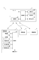
実施形態の走行路情報生成システム全体の構成を表すブロック図である。
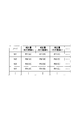
サーバの補正量DBに保存される補正量データの構成を表す説明図である。
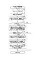
サーバの制御部にて実行される補正量DB更新処理を表すフローチャートである。
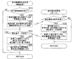
サーバ及び車載装置の制御部にて補正量を送受信するために実行される制御処理を表すフローチャートである。
地図データから得られる走行路及び車両から得られる走行軌跡を表す説明図である。
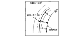
地図上の走行路と走行軌跡との距離を判定する動作を表す説明図である。
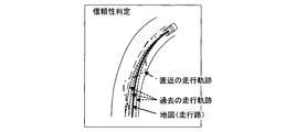
車両から取得した走行軌跡の信頼性を判定する動作を表す説明図である。
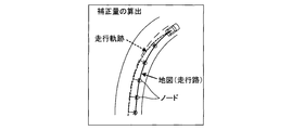
走行軌跡から地図上の走行路の補正量を算出する動作を表す説明図である。
補正量を用いて走行路情報を生成する動作を表す説明図である。
最終的に得られる走行路情報の一例を表す説明図である。
走行環境によって変化する走行路情報の一例を表す説明図である。
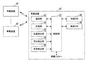
変形例の車載装置の構成を表すブロック図である。
以下、本開示の実施形態について、図面を用いて説明する。
なお、本開示は、下記の実施形態によって何ら限定して解釈されない。また、下記の実施形態の構成の一部を、課題を解決できる限りにおいて省略した態様も本開示の実施形態である。また、特許請求の範囲に記載した文言のみによって特定される開示の本質を逸脱しない限度において考え得るあらゆる態様も本開示の実施形態である。また、下記の実施形態の説明で用いる符号を特許請求の範囲にも適宜使用しているが、これは本開示の理解を容易にする目的で使用しており、本開示の技術的範囲を限定する意図ではない。
なお、本開示は、下記の実施形態によって何ら限定して解釈されない。また、下記の実施形態の構成の一部を、課題を解決できる限りにおいて省略した態様も本開示の実施形態である。また、特許請求の範囲に記載した文言のみによって特定される開示の本質を逸脱しない限度において考え得るあらゆる態様も本開示の実施形態である。また、下記の実施形態の説明で用いる符号を特許請求の範囲にも適宜使用しているが、これは本開示の理解を容易にする目的で使用しており、本開示の技術的範囲を限定する意図ではない。
図1に示すように、本実施形態の走行路情報生成システム1は、通信ネットワーク上のサーバ2と、複数の車両にそれぞれ搭載された複数の車載装置4と、を備える。
なお、通信ネットワークは、サーバ2が複数の車載装置4との間で電波による無線通信を実施できるようにするためのものであり、例えば、モバイル通信網やインターネットを利用できる。
なお、通信ネットワークは、サーバ2が複数の車載装置4との間で電波による無線通信を実施できるようにするためのものであり、例えば、モバイル通信網やインターネットを利用できる。
サーバ2は、通信部22と、地図DB24と、軌跡DB26と、補正量DB28と、制御部30と、を備える。なお、DBは、データベースを表す。
通信部22は、通信ネットワークを介して複数の車載装置4との間で無線通信を行うためのものである。
通信部22は、通信ネットワークを介して複数の車載装置4との間で無線通信を行うためのものである。
地図DB24は、車両が走行可能な走行路を含む地図データが予め記憶された記憶装置であり、例えば、CD、DVD等の光ディスクとその読み取り装置、或いは、ハードディスク、ソリッドステートディスク等の読み書き可能な記憶媒体にて構成される。
軌跡DB26は、車載装置4から受信した軌跡データを記憶するための記憶装置であり、補正量DB28は、地図DB24に記憶された地図データに対する補正量データを記憶するための記憶装置である。
軌跡DB26、補正量DB28は、軌跡データや補正量データを新規登録したり、更新したりする必要があるので、例えば、ハードディスク、ソリッドステートディスク、不揮発性メモリ等からなる読み書き可能な記憶媒体にて構成される。
制御部30は、コンピュータを用いて構成されており、プログラムに従い補正量DB更新処理及び補正量送信処理を実行する。
補正量DB更新処理は、軌跡DB26に記憶された車両の実際の走行軌跡を表す軌跡データを用いて、地図DB24に記憶された地図データから得られる走行路を補正するための補正量を算出し、補正量DB28内に補正量データとして記憶するための処理である。
補正量DB更新処理は、軌跡DB26に記憶された車両の実際の走行軌跡を表す軌跡データを用いて、地図DB24に記憶された地図データから得られる走行路を補正するための補正量を算出し、補正量DB28内に補正量データとして記憶するための処理である。
補正量DB更新処理において、補正量は、地図データから得られる走行路上のノードN1、N2、N3…毎に、その走行路と車両の走行軌跡との差分(換言すれば位置ずれ)を求めることにより、各ノードの位置を補正する補正量として設定される。
また、軌跡DB26には、車両から取得した軌跡データが、車両の走行環境に関連付けて記憶されており、補正量は、その走行環境を複数に分類した走行環境A、B、C…毎に設定される。
そして、補正量DB28には、図2に例示するように、地図データから得られる走行路上のノードN1、N2、N3…毎に、各走行環境A、B…に対応した補正量R1(A)、R2(A)、R3(A)…、R1(B)、R2(B)、R3(B)…が記憶される。
なお、走行環境A、B、C…は、地図データから得られる走行路に対するずれ量が変化すると想定される条件により、適宜分類される。
これら条件としては、例えば、深夜、日中等の時間帯、冬季、梅雨等の季節、天候、気温等の気象条件、豪雪地帯、山岳地帯等の地域、等である。
これら条件としては、例えば、深夜、日中等の時間帯、冬季、梅雨等の季節、天候、気温等の気象条件、豪雪地帯、山岳地帯等の地域、等である。
また、補正量DB28に記憶される補正量は、地図データから得られる全走行路に対し設定するようにされていてもよく、予め設定された特定の走行路に対し設定するようにしてもよい。この特定の走行路としては、例えば、交差点や急カーブ等、走行路の環境変化によって車両を地図通りに走行させることができなくなる場所の走行路を設定してもよい。
次に、補正量送信処理は、補正量DB28に記憶された補正量データを、通信ネットワークを介して車載装置4に送信する処理を行う。そして、この補正量送信処理では、車載装置4からの要求に従い、車載装置4を搭載した車両の位置や走行環境に対応した地図データを補正量DB28から読み出し、車載装置4に送信する。
一方、車載装置4は、通信部42と、記憶部44と、制御部50と、位置検出部52と、方位検出部54と、車速検出部56と、を備える。なお、車載装置4は、複数の車両にそれぞれ搭載されるが、構成は同じである。
通信部42は、サーバ2との間で電波による無線通信を行うためのものであり、記憶部44は、各種データを記憶するためのものである。
記憶部44には、車両に搭載されたナビゲーション装置等から取得した地図データ、自車両の走行軌跡を表す軌跡データ、サーバ2から取得した補正量データ、等が記憶される。このため、記憶部44には、データの書き換えが可能な不揮発性メモリが用いられる。
記憶部44には、車両に搭載されたナビゲーション装置等から取得した地図データ、自車両の走行軌跡を表す軌跡データ、サーバ2から取得した補正量データ、等が記憶される。このため、記憶部44には、データの書き換えが可能な不揮発性メモリが用いられる。
位置検出部52は、車載装置4が搭載された自車両の絶対位置を測定するためのものである。本実施形態では、例えば、GPS受信機等、衛星測位システム用の人工衛星から送信された電波を受信し、自車両の緯度、経度及び高度や現在時刻を検出する受信装置が利用される。なお、GPSは、Global Positioning Systemの略である。
方位検出部54は、自車両の走行方向(例えば、絶対方位)を検出するためのものである。本実施形態では、車両に加えられる回転運動の角速度に応じた検出信号を出力するジャイロスコープが用いられる。なお、ジャイロスコープに代えて、又はジャイロスコープとともに、例えば、地磁気に基づいて自車両の絶対方位を検出する地磁気センサなどを用いてもよい。
車速検出部56は、自車両の走行速度を検出するためのものであり、車両に搭載された車速センサが利用される。
制御部50は、コンピュータを用いて構成されており、プログラムに従い各種処理を実行する。
制御部50は、コンピュータを用いて構成されており、プログラムに従い各種処理を実行する。
具体的には、制御部50は、自車両の走行時に、位置検出部52、方位検出部54及び車速検出部56を用いて、走行軌跡を表す走行路情報を定期的に測定し、測定時刻と共に記憶部44に記憶する走行軌跡計測処理を行う。
なお、走行路情報は、車両の位置、進行方位、及び車速を表す情報であり、その測定時刻を表す時刻情報と共に記憶部44に記憶される。
この測定時刻は、車両の走行環境を表す情報の一つであるが、測定時刻に加えて、タイヤのスリップ率、ワイパーの作動状態、外気温等についても、車両の走行環境を表す車両情報として、上記走行路情報と共に記憶部44に記憶するようにしてもよい。
この測定時刻は、車両の走行環境を表す情報の一つであるが、測定時刻に加えて、タイヤのスリップ率、ワイパーの作動状態、外気温等についても、車両の走行環境を表す車両情報として、上記走行路情報と共に記憶部44に記憶するようにしてもよい。
この場合、タイヤのスリップ率は、車両に搭載されたセンサにて検出可能な車輪の回転速度と車速とから求めることができ、路面状態を表す道路情報として利用できる。また、ワイパーの作動状態は、天候(雨天)を表す気象情報として使用できる。
また、制御部50は、記憶部44に記憶された測定時刻ごとの走行路情報を、自車両の識別情報と共に、走行軌跡を表す軌跡データとして、所定のタイミングでサーバ2へ送信する軌跡データ送信処理も実行する。
なお、軌跡データをサーバ2へ送信するタイミングは、車両の走行中、一定期間毎に発生するようにしてもよい。また、この送信タイミングは、車両が停車若しくは駐車されたタイミングであってもよいし、運転者が外部操作によって送信指令を入力したタイミングであってもよい。
また、制御部50は、通信機能を有し、例えば、CAN等の車載LANを介して、他の車載機との間でデータ通信が可能である。
そして、制御部50は、 車載LANを介して他の車載機から走行路情報の要求信号を受けると、車両の走行予定経路となる走行路情報を生成し、車載LANを介して出力する、走行路情報生成処理を実行する。
そして、制御部50は、 車載LANを介して他の車載機から走行路情報の要求信号を受けると、車両の走行予定経路となる走行路情報を生成し、車載LANを介して出力する、走行路情報生成処理を実行する。
なお、車載装置4に対し、走行路情報の要求信号を入力する他の車載機としては、運転者に対し走行案内を行うためのナビゲーション装置や、車両を自動運転させるための走行制御装置等を挙げることができる。
そして、本実施形態では、これら車載機が、サーバ2の地図DB24に記憶された地図データと同様の地図データが記憶された記憶媒体を有し、制御部50は、その車載機から地図データを取得し、車両の走行経路となる走行路情報を生成するものとする。
次に、サーバ2の制御部30にて実行される補正量DB更新処理と補正量送信処理、及び、車載装置4の制御部50にて実行される走行路情報生成処理について説明する。
補正量DB更新処理は、通信部22にて、車載装置4から送信されてきた軌跡データが受信されることにより起動される。
補正量DB更新処理は、通信部22にて、車載装置4から送信されてきた軌跡データが受信されることにより起動される。
図3に示すように、補正量DB更新処理が開始されると、S110にて、通信部22で受信された軌跡データを取り込み、S120に移行する。
S120では、S110で取得した軌跡データから得られる情報(例えば、測定時刻、車両位置)、走行路周囲に設置された各種センサ(例えば、温度センサ、日射センサ)、及び、外部サーバを利用して、上述した各種走行環境を取得する。
S120では、S110で取得した軌跡データから得られる情報(例えば、測定時刻、車両位置)、走行路周囲に設置された各種センサ(例えば、温度センサ、日射センサ)、及び、外部サーバを利用して、上述した各種走行環境を取得する。
次に、S130では、図5に示すように、地図DB24に記憶された地図データから、S110で取得した軌跡データに対応する地図上の走行路を取得すると共に、その軌跡データから走行軌跡を取得し、走行路と走行軌跡との間の距離を算出する。
具体的には図6に例示するように、地図上の走行路と走行軌跡とで対応する位置を複数特定し、各位置の間の距離Lを求め、その距離Lの最大値若しくは平均値を、走行路と走行軌跡とのずれ量を表す距離として算出する。
次に、S140では、S130にて算出した距離が予め設定された閾値以下であるか否かを判断することで、地図上の走行路と走行軌跡とが近いか否かを判定する。そして、距離が閾値以下で、地図上の走行路と走行軌跡とが近い場合には、S150に移行し、そうでなければ、今回取得した軌跡データは地図上の走行路と離れすぎているので異常であると判断し、当該補正量DB更新処理を終了する。
S150では、軌跡DB26から、S110にて取得した軌跡データから得られる走行軌跡(換言すれば走行路)に対応し、且つ、S120にて取得した走行環境と同じ走行環境の軌跡データを抽出する。
また、S150では、その抽出した軌跡データから得られる走行軌跡と、S110にて取得した軌跡データから得られる走行軌跡とを比較することで、今回取得した軌跡データの信頼度を算出する。
なお、この信頼度の算出は、例えば、今回取得した軌跡データを構成する走行路情報のサンプル数が、所定の閾値以上となる軌跡データに対し行われ、サンプル数が少ない軌跡データについては、信頼度が最低値として設定される。
また、サンプル数が閾値以上の軌跡データに対しては、その軌跡データから得られる走行軌跡が、軌跡DB26から抽出した軌跡データから得られる走行軌跡に対し、どの程度分散しているのかを表す分散値を算出し、これを信頼度として設定する。
そして、続くS160では、S150にて算出した信頼度は予め設定された閾値以上であるか否かを判断することにより、S110にて取得した軌跡データは統計的に信頼性が高いか否かを判定する。
つまり、本実施形態では、図7に例示するように、今回取得した軌跡データから得られる直近の走行軌跡と軌跡DB26内の過去の走行軌跡とを比較し、今回取得した軌跡データが統計的に信頼性の高い軌跡データであるか否かを判断するのである。
S160にて、S150にて算出した信頼度が閾値以上であると判断されると、S110にて取得した軌跡データは信頼性が高いので、S170に移行し、そうでなければ、当該補正量DB更新処理を終了する。なお、この終了時には、S110にて今回取得した軌跡データは破棄される。
S170では、S110にて取得した軌跡データを、新たな軌跡データとして軌跡DB26に保存し、S180に移行する。
なお、S170にて、軌跡DB26への軌跡データを保存する際には、S120にて取得した各種走行環境の情報を付与する。また、軌跡DB26へ軌跡データを保存する際、軌跡DB26に既に記憶されている同一走行環境の軌跡データの数が、上限に達している場合には、車載装置4側で生成された時期が最も古い軌跡データを削除し、新たな軌跡データを保存するようにしてもよい。
なお、S170にて、軌跡DB26への軌跡データを保存する際には、S120にて取得した各種走行環境の情報を付与する。また、軌跡DB26へ軌跡データを保存する際、軌跡DB26に既に記憶されている同一走行環境の軌跡データの数が、上限に達している場合には、車載装置4側で生成された時期が最も古い軌跡データを削除し、新たな軌跡データを保存するようにしてもよい。
次に、S180では、軌跡DB26から、S170にて保存した軌跡データと、この軌跡データに対応し且つ同一走行環境の過去の軌跡データとを利用して、車両が実際に走行している走行軌跡を推定し、S190に移行する。
S190では、S180にて推定した走行軌跡に対応する領域の地図データを地図DB24から取得する。また、S190では、地図DB24から取得した地図データから得られる地図上の走行路とS180で推定した走行軌跡との差分を、走行路の補正量として算出して、補正量DB28に記憶し、当該補正量DB更新処理を終了する。
S190での補正量(換言すれば差分)の算出は、図8に示すように、地図データから得られる走行路上の各ノードから、走行路に対し直交する方向に走行軌跡がどれだけずれているか否かを求めることにより行われる。
つまり、本実施形態では、例えば、各ノードの位置から、走行路に対し直交する方向に位置する走行軌跡までの距離及び方向を、各ノードの走行軌跡に対する横偏差(換言すれば差分)として求め、この横偏差から補正量を設定する。
なお、この補正量は、走行路の各ノードの地図座標(例えば、X、Y、Zの三次元座標)上での座標位置と、各ノードを走行軌跡上に移動させたときの座標位置との差分(例えば、ΔX、ΔY、ΔZ)を求め、これを補正量として設定するようにしてもよい。
また、S190にて、補正量DB28に補正量を記憶する際、今回算出した補正量に対応する走行路に対する補正量が、補正量DB28に既に記憶されている場合には、今回算出した補正量を上書きすることで、補正量データを更新する。
次に、車載装置4の制御部50は、図4に示す走行路情報生成処理をメインルーチンの一つとして繰り返し実行する。
この走行路情報生成処理においては、S210にて、他の車載機から車載LANを介して走行路情報を要求されたか否かを判断する。そして、走行路情報を要求されていなければ、当該走行路情報生成処理を終了し、走行路情報を要求されていれば、S220に移行する。
この走行路情報生成処理においては、S210にて、他の車載機から車載LANを介して走行路情報を要求されたか否かを判断する。そして、走行路情報を要求されていなければ、当該走行路情報生成処理を終了し、走行路情報を要求されていれば、S220に移行する。
S220では、現在の車両位置を含み、且つ、車載機から要求された走行路情報を生成すべき領域の地図データを、車載機から取得する。
次に、S230では、補正量要求信号を、通信部42を介してサーバ2へ送信する。なお、サーバ2へ送信される補正量要求信号には、現在の車両位置を表す位置情報、車両側で得られる走行環境を表す情報、及び、補正対象となる走行路を表す情報が付与される。
次に、S230では、補正量要求信号を、通信部42を介してサーバ2へ送信する。なお、サーバ2へ送信される補正量要求信号には、現在の車両位置を表す位置情報、車両側で得られる走行環境を表す情報、及び、補正対象となる走行路を表す情報が付与される。
一方、サーバ2の制御部30は、図4に示す補正量送信処理をメインルーチンの一つとして繰り返し実行する。
この補正量送信処理では、S310にて、車載装置4から送信された補正量要求信号が通信部22で受信されたか否かを判断する。そして、S310にて、補正量要求信号が受信されたと判断されると、S320に移行し、補正量要求信号は受信されていないと判断されると、当該補正量送信処理を終了する。
この補正量送信処理では、S310にて、車載装置4から送信された補正量要求信号が通信部22で受信されたか否かを判断する。そして、S310にて、補正量要求信号が受信されたと判断されると、S320に移行し、補正量要求信号は受信されていないと判断されると、当該補正量送信処理を終了する。
S320では、車載装置4側で走行路情報を生成するのに要する補正量データを、補正量DB28から取得する。
なお、S320にて補正量DB28から補正量データを取得する際には、補正量要求信号に含まれる車両位置、走行環境、及び、走行路を表す情報や、気象情報等、補正量要求信号に含まれない走行環境が利用される。この結果、S320では、これら各情報に対応した補正量データが、補正量DB28から取得されることになる。
なお、S320にて補正量DB28から補正量データを取得する際には、補正量要求信号に含まれる車両位置、走行環境、及び、走行路を表す情報や、気象情報等、補正量要求信号に含まれない走行環境が利用される。この結果、S320では、これら各情報に対応した補正量データが、補正量DB28から取得されることになる。
そして、S330では、S320にて取得した補正量データを、補正量要求信号を送信してきた車載装置4に送信し、当該補正量送信処理を終了する。
次に、車載装置4の制御部50においては、S230にて補正量要求信号をサーバ2へ送信した後は、S240に移行して、サーバ2から送信された補正量データが通信部42で受信されるのを待つ。
次に、車載装置4の制御部50においては、S230にて補正量要求信号をサーバ2へ送信した後は、S240に移行して、サーバ2から送信された補正量データが通信部42で受信されるのを待つ。
そして、S240にて、補正量データが受信されたと判断されると、S250に移行して、車載機から取得した地図データ上の走行路を、サーバ2から取得した補正量データに基づき補正し、走行路情報を生成する。
なお、この走行路情報は、図9に例示するように、車載機から取得した地図データから得られる走行路上の各ノードの位置を各ノードに対応した補正量にて補正することで、補正後の走行路上のノードの位置を設定し、各ノードを接続することにより生成される。
S250にて走行路情報が生成されると、S260に移行して、その走行路情報を、車載LANを介して、要求元の車載機(例えば、ナビゲーション装置、走行制御装置)に送信し、当該走行路情報生成処理を終了する。
以上説明したように、本実施形態の走行路情報生成システム1は、サーバ2と、車両毎に搭載される複数の車載装置4とから構成され、サーバ2側では、制御部30が、複数の車載装置4から、車両の実走行路に対応した軌跡データを取得する。
そして、制御部30は、その軌跡データから得られる走行軌跡と、地図DB24に記憶された地図データから得られる地図上の走行路との差分から、走行路の補正量データを求め、補正量DB28に保存する。
また、制御部30は、車載装置4から補正量の要求信号を受けると、車載装置4からの要求に対応した補正量データを補正量DB28から読み込み、要求信号を送信してきた車載装置4に送信する。
すると、車載装置4側では、制御部50が、サーバ2から送信されてきた補正量データを使って、地図データから得られる走行路を補正し、走行案内若しくは車両の自動運転に利用する走行路情報を生成する。
このため、本実施形態の走行路情報生成システム1によれば、車載装置4において、地図データから得られる走行路を、補正量データを使って補正することができるようになり、この補正により、車両を実際に走行させるべき走行路情報を生成することができる。
よって、本実施形態によれば、車両の走行環境の変化によって、地図データから得られる走行路が車両を走行させるのに適した最適走行路からずれたとしても、そのずれに応じて走行路を補正し、他の車載機に対して最適な走行路情報を提供できることになる。
例えば、図10に示すように、道路がT字路で、交差点に進入する車両が右折しようとする場合、地図データから得られる走行路(実線で示す)では、右折方向への曲率が高くなりすぎ、車両運動の特性上、車両を安全に走行させることができないことがある。
これに対し、本実施形態の走行路情報生成システム1によれば、この交差点での右折車両の走行軌跡を表す軌跡データを収集し、その軌跡データに基づき、走行路を補正し、車両が実際の走行軌跡に沿って走行するようにすることができる。
また例えば、図11に示すように、冬季に、車両が雪道である道路を走行する場合、路肩に雪が積もっていると、車両は、積雪を避けるため、地図データから得られる走行路よりも、積雪とは反対側にずれて走行することになり、自動運転車両も同様に走行させる必要がある。
この場合、本実施形態によれば、この走行時と同様の走行環境で収集した軌跡データを使って、地図データから得られる走行路を補正することができる。
よって、本実施形態の走行路情報生成システムによれば、図10、図11に例示した条件下でも、最終的に得られる走行路情報は、同一の走行環境下で車両が実際に走行しているときの走行軌跡に対応した走行路を表す。
よって、本実施形態の走行路情報生成システムによれば、図10、図11に例示した条件下でも、最終的に得られる走行路情報は、同一の走行環境下で車両が実際に走行しているときの走行軌跡に対応した走行路を表す。
従って、本実施形態によれば、車両を自動運転させる走行制御装置等の車載機に対し、車両の実際の走行環境に応じて、適正な走行路情報(換言すれば走行予定経路)を提供することが可能となる。
また、本実施形態の走行路情報生成システム1では、軌跡データから得られる走行軌跡を用いて元の地図データを補正しないので、地図データを、初期状態のまま、走行路の基準データとして保持することができる。
このため、本実施形態によれば、基準となる地図データが誤って更新されることを防ぐことができる。従って、地図データを利用できなくなるようなことはない。また、コンピュータの処理負荷により地図データの更新に時間がかかり、車両の走行環境に対応した最新の地図データにて走行路情報を生成できなくなる、という問題が発生するのを抑制できる。従って、本実施形態によれば、車載装置4で生成される走行路情報の信頼性を高めることができる。
また、サーバ2の制御部30は、車載装置4から軌跡データを収集する度に、その軌跡データを車両の走行環境に応じて分類して、軌跡DB26に保存する。そして、軌跡DB26に新たな軌跡データを保存する度に、その軌跡データと走行環境が同じ軌跡データを軌跡DB26から読み出し、その読み出した複数の軌跡データを用いて、補正量データを逐次生成し、補正量DB28を更新する。
従って、補正量DB28に記憶される補正量データは、走行環境毎に、最新の走行軌跡に対応して更新されることになり、車載装置4側では、その最新の補正量データを用いて走行路情報を生成することで、より適正な走行路情報を生成することが可能となる。
また、サーバ2の制御部30は、軌跡DB26に補正量データ生成用の軌跡データを保存する際、車載装置4から取得した軌跡データが、地図上の走行路からの距離が遠く異常であるか否か、或いは、統計的に信頼性が高いか否かを判断する。そして、車載装置4から取得した軌跡データが正常であり、信頼性が高いと判断すると、その軌跡データを、軌跡DB26に記憶する。このため、軌跡DB26に、信頼性の低い異常な軌跡データが記憶されるのを抑制することができる。
なお、本実施形態においては、サーバ2が、本開示の軌跡データ取得部、走行環境取得部、及び、補正量算出部として機能し、車載装置4が、本開示の地図データ取得部、補正量取得部、及び走行路情報生成部として機能する。
具体的には、軌跡データ取得部としての機能は、制御部30にて実行されるS110の処理にて実現され、走行環境取得部としての機能は、同じくS120の処理にて実現され、補正量算出部としての機能は、S130~S190の処理にて実現される。
また、地図データ取得部としての機能は、制御部50にて実行されるS220の処理にて実現され、補正量取得部としての機能は、同じくS230、S240の処理にて実現され、走行路情報生成部としての機能は、同じくS250の処理にて実現される。
以上、本開示の一実施形態について説明したが、本開示は、上記実施形態に限定されるものではなく、本開示の要旨を逸脱しない範囲内にて種々の態様をとることができる。
例えば、上記実施形態では、本発明の軌跡データ取得部、走行環境取得部、及び、補正量算出部としての機能をサーバ2に設けるものとして説明した。これに対し、これらの機能を車載装置40側に設け、車載装置40単体で、本開示の走行路情報生成システムを実現するようにしてもよい。
例えば、上記実施形態では、本発明の軌跡データ取得部、走行環境取得部、及び、補正量算出部としての機能をサーバ2に設けるものとして説明した。これに対し、これらの機能を車載装置40側に設け、車載装置40単体で、本開示の走行路情報生成システムを実現するようにしてもよい。
この場合、車載装置40には、図12に示すように、地図DB46及び軌跡DB48を設けるようにすればよい。また、通信部42は、自車両周囲の車両に搭載された他の車載装置40との間で直接、若しくは、モバイル通信網やインターネット等の通信ネットワークを介して、電波による無線通信を行うようにする。
このようにすれば、制御部50において、上記実施形態と同様の手順で、補正量DB更新処理及び走行路情報生成処理を順次実行することで、補正量データの生成、補正量データに基づく走行路の補正、及び、補正後の走行路情報の出力を実施することができる。
なお、この場合、補正量データは、走行路情報が必要なときに、軌跡DB48に蓄積された最新の軌跡データを用いて算出し、記憶部44に一時保存するようにすればよいので、走行環境毎に補正量データを記憶するための補正量DBは特に設ける必要はない。
つまり、上記実施形態と同様のS110~S180の手順で補正量データを算出した場合、その算出結果は、記憶部44に記憶するようにすればよい。
また、図12に示す車載装置40には、地図データが記憶された地図DB46が備えられているが、この地図DB46についても、必ずしも設ける必要はなく、ナビゲーション装置等の他の車載機から、地図データを取得するようにしてもよい。
また、図12に示す車載装置40には、地図データが記憶された地図DB46が備えられているが、この地図DB46についても、必ずしも設ける必要はなく、ナビゲーション装置等の他の車載機から、地図データを取得するようにしてもよい。
また、上記実施形態の車載装置4は、他の車載機から地図データを取得するものとして説明したが、図12と同様に、地図DB46を備えていてもよく、或いは、サーバ2から所望領域の地図データを取得するようにしてもよい。
一方、上記実施形態では、軌跡DB26には、複数の軌跡データが記憶されていて、補正量データを生成する際には、その複数の軌跡データを用いるものとして説明したが、例えば、複数の軌跡データの中の一部を使って、補正量データを生成するようにしてもよい。
この場合、補正量データの生成に利用する軌跡データを選択する必要があるが、この選択は、サンプリング日時が新しいものを選択するようにしてもよく、信頼度が高いものを選択するようにしてもよい。
同様に、図12に示す車載装置40においても、軌跡DB48に記憶された複数の軌跡データの中から、補正量データを生成するのに用いる軌跡データを選択するようにしてもよい。但し、車載装置40の軌跡DB48には、自車両の走行軌跡を表す軌跡データと、他車両から取得した軌跡データとが記憶されることになるので、同時期に生成された軌跡データが複数存在する場合には、自車両の軌跡データを優先的に選択するようにするとよい。
また次に、上記実施形態では、サーバ2は、車載装置4からの要求に従い、車載装置4を搭載した車両の位置や走行環境に対応した補正量データを補正量DB28から読み出し、送信するものとして説明した。
これに対し、サーバ2は、補正量DB28を更新する度に、更新した補正量データを全ての車載装置4に送信するようにしてもよい。このようにすれば、各車載装置4は、地図データに対する最新の補正量データを全て保持することができ、走行路情報を生成する度にサーバ2から補正量データを取得する必要がないので、走行路情報の生成(換言すれば走行路の補正)を短時間で実施できる。
また、上記実施形態では、サーバ2側で補正量データを生成するものとして説明したが、サーバ2側では、複数の車載装置4から取得した軌跡データを軌跡DB48に保存し、車載装置4は、サーバ2から軌跡データを取得して補正量を算出するようにしてもよい。
1…走行路情報生成システム、2…サーバ、4…車載装置、22…通信部、24…地図DB、26…軌跡DB、28…補正量DB、30…制御部、40…車載装置、42…通信部、44…記憶部、46…地図DB、48…軌跡DB、50…制御部、52…位置検出部、54…方位検出部、56…車速検出部。
Claims (15)
- 車両が走行可能な走行路を含む地図データを取得する地図データ取得部(4、S220)と、
車両が前記走行路を実際に走行したときの走行軌跡を表す軌跡データを取得する軌跡データ取得部(2、S110)と、
前記軌跡データに基づき、前記地図データから車両の走行に適した走行路情報を生成するのに要する補正量を算出する補正量算出部(2、S130~S190)と、
前記地図データから得られる走行路を前記補正量にて補正することで、前記走行路情報を生成する走行路情報生成部(4、S250)と、
を備えた車両の走行路情報生成システム。 - 前記軌跡データ取得部は、複数の車両から前記軌跡データを取得するように構成されている、請求項1に記載の車両の走行路情報生成システム。
- 前記軌跡データ取得部にて取得される軌跡データに対応する走行環境を取得する走行環境取得部(2、S120)を備え、
前記補正量算出部は、前記軌跡データに基づき算出した前記補正量を、前記走行環境に関連付けて保持するように構成され、
前記走行路情報生成部は、前記補正量算出部に保持された前記補正量のうち、車両の現在の走行環境に対応した補正量を用いて、前記走行路情報を生成するように構成されている、請求項1又は請求項2に記載の車両の走行路情報生成システム。 - 前記補正量算出部は、前記地図データと前記軌跡データとの差分に基づき、前記補正量を算出するように構成されている、請求項1~請求項3の何れか1項に記載の車両の走行路情報生成システム。
- 前記補正量算出部は、前記地図データと前記軌跡データとの差分を逐次更新し、前記補正量を算出するように構成されている、請求項4に記載の車両の走行路情報生成システム。
- 前記補正量算出部は、前記地図データと前記軌跡データとの差分を、前記走行環境毎に逐次更新するか又は算出し、該更新又は算出した差分に基づき前記補正量を前記走行環境毎に設定するように構成されている、請求項3に記載の車両の走行路情報生成システム。
- 前記地図データ取得部は、前記地図データを初期状態として保持するように構成されている、請求項1~請求項6の何れか1項に記載の車両の走行路情報生成システム。
- 前記補正量算出部は、前記地図データから得られる前記走行路の各ノードで当該走行路に直交する方向への補正距離、又は、前記各ノードの前記地図データの座標上での位置偏差を、前記補正量として算出するよう構成されている、請求項1~請求項7の何れか1項に記載の車両の走行路情報生成システム。
- 前記軌跡データ取得部は、車両から取得した過去の走行軌跡を前記軌跡データとして保持するように構成されている、請求項1~請求項8の何れか1項に記載の車両の走行路情報生成システム。
- 前記軌跡データ取得部は、車両に搭載された車両位置検出用のセンサから得られる位置情報を、前記軌跡データとして取得するように構成されている、請求項1~請求項9の何れか1項に記載の車両の走行路情報生成システム。
- 当該走行路情報生成システムは車両に搭載され、
前記軌跡データ取得部は、自車両と他車両とから前記軌跡データを取得可能に構成され、
前記補正量算出部は、前記軌跡データ取得部にて取得されて前記補正量の算出に利用可能な前記軌跡データとして、自車両及び他車両の両方から取得された複数の軌跡データが存在する場合に、自車両から取得された前記軌跡データを利用し、前記補正量を算出するように構成されている、請求項1~10の何れか1項に記載の車両の走行路情報生成システム。 - 前記補正量算出部は、前記軌跡データ取得部にて取得されて前記補正量の算出に利用可能な軌跡データが複数存在する場合、生成時期が新しい軌跡データを利用し、前記補正量を算出するように構成されている、請求項1~請求項11の何れか1項に記載の車両の走行路情報生成システム。
- 前記補正量算出部は、前記軌跡データ取得部にて取得されて前記補正量の算出に利用可能な軌跡データが複数存在する場合、統計的に信頼性の高い軌跡データを利用し、前記補正量を算出するよう構成されている、請求項1~請求項12の何れか1項に記載の車両の走行路情報生成システム。
- 前記走行環境取得部は、前記軌跡データ取得部が前記軌跡データを取得した車両又は該車両の走行路側に設置されたセンサから、当該軌跡データに対応する走行環境を取得するよう構成されている、請求項3又は請求項3を引用する請求項4~請求項13の何れか1項に記載の車両の走行路情報生成システム。
- 車両が走行可能な走行路を含む地図データを取得する地図データ取得部と、
前記地図データから車両の走行に適した走行路情報を生成するのに要する補正量を取得する補正量取得部(4、S230、S240)と、
前記地図データから得られる前記走行路を前記補正量取得部にて取得された前記補正量で補正することで、前記走行路情報を生成する走行路情報生成部と、
を備えた車載装置。
Priority Applications (1)
| Application Number | Priority Date | Filing Date | Title |
|---|---|---|---|
| US15/775,799 US20180328744A1 (en) | 2015-11-13 | 2016-11-11 | Travelling road information generation system of vehicle and on-board apparatus based on correction amount |
Applications Claiming Priority (2)
| Application Number | Priority Date | Filing Date | Title |
|---|---|---|---|
| JP2015223181A JP6524892B2 (ja) | 2015-11-13 | 2015-11-13 | 車両の走行路情報生成システム |
| JP2015-223181 | 2015-11-13 |
Publications (1)
| Publication Number | Publication Date |
|---|---|
| WO2017082398A1 true WO2017082398A1 (ja) | 2017-05-18 |
Family
ID=58695489
Family Applications (1)
| Application Number | Title | Priority Date | Filing Date |
|---|---|---|---|
| PCT/JP2016/083555 Ceased WO2017082398A1 (ja) | 2015-11-13 | 2016-11-11 | 補正量に基づいた車両の走行路情報生成システム及び車載装置 |
Country Status (3)
| Country | Link |
|---|---|
| US (1) | US20180328744A1 (ja) |
| JP (1) | JP6524892B2 (ja) |
| WO (1) | WO2017082398A1 (ja) |
Cited By (2)
| Publication number | Priority date | Publication date | Assignee | Title |
|---|---|---|---|---|
| CN110570649A (zh) * | 2018-06-05 | 2019-12-13 | 高德软件有限公司 | 机动车流量检测方法、设备工作状态检测方法及相应装置 |
| JP2020154624A (ja) * | 2019-03-19 | 2020-09-24 | 株式会社Subaru | 自動運転車両の交通制御システム |
Families Citing this family (17)
| Publication number | Priority date | Publication date | Assignee | Title |
|---|---|---|---|---|
| US10870426B2 (en) * | 2017-06-22 | 2020-12-22 | Magna Electronics Inc. | Driving assistance system with rear collision mitigation |
| JP6969962B2 (ja) * | 2017-10-05 | 2021-11-24 | トヨタ自動車株式会社 | 車両の運転支援及び/又は走行制御のための地図情報提供システム |
| JP2019105684A (ja) | 2017-12-11 | 2019-06-27 | 株式会社デンソー | 交差点内の走行軌道データ生成装置、交差点内の走行軌道データ生成プログラム及び記憶媒体 |
| JP6988450B2 (ja) * | 2017-12-22 | 2022-01-05 | 株式会社デンソー | 交差点内の走行軌道データ生成装置、交差点内の走行軌道データ生成プログラム及び記憶媒体 |
| WO2019176083A1 (ja) * | 2018-03-16 | 2019-09-19 | 株式会社日立製作所 | 移動体制御装置 |
| EP4094996A1 (en) * | 2018-06-29 | 2022-11-30 | Aptiv Technologies Limited | A method comprising distributing through a power interface of a power and data center power and data for automotive applications |
| JP7360269B2 (ja) * | 2019-08-01 | 2023-10-12 | 株式会社Subaru | 車両の走行制御装置 |
| KR102415619B1 (ko) * | 2019-10-24 | 2022-07-01 | 마스코리아 주식회사 | 도로의 위험구간 추정방법 및 시스템 |
| CN113129438B (zh) * | 2020-01-15 | 2023-06-23 | 阿里巴巴集团控股有限公司 | 一种车道线的精度提升方法、装置及可读存储介质 |
| JP7380616B2 (ja) * | 2021-03-05 | 2023-11-15 | 株式会社デンソー | 自動運転制御装置、自動運転制御方法、及び自動運転制御プログラム |
| JP7643127B2 (ja) * | 2021-03-24 | 2025-03-11 | 日産自動車株式会社 | 運転支援方法及び運転支援装置 |
| US20240085213A1 (en) * | 2021-03-25 | 2024-03-14 | Hitachi Astemo, Ltd. | Map storage device |
| CN113505687B (zh) * | 2021-07-08 | 2024-08-09 | 北京星云互联科技有限公司 | 设备测试方法、装置、电子设备、系统和存储介质 |
| JP7464028B2 (ja) * | 2021-09-16 | 2024-04-09 | トヨタ自動車株式会社 | 情報処理装置、車両、情報処理方法及びコンピュータプログラム |
| JP7764177B2 (ja) * | 2021-09-24 | 2025-11-05 | 株式会社トプコン | 墨出し装置、墨出し装置の制御方法およびプログラム |
| CN114625744A (zh) * | 2022-03-03 | 2022-06-14 | 北京百度网讯科技有限公司 | 电子地图的更新方法和装置 |
| US20240383479A1 (en) * | 2023-05-16 | 2024-11-21 | Magna Electronics Inc. | Vehicular sensing system with lateral threat assessment |
Citations (2)
| Publication number | Priority date | Publication date | Assignee | Title |
|---|---|---|---|---|
| JP2009227196A (ja) * | 2008-03-25 | 2009-10-08 | Mazda Motor Corp | 車両の運転支援装置 |
| JP2010128959A (ja) * | 2008-11-28 | 2010-06-10 | Toyota Motor Corp | 走行環境データベース管理装置 |
Family Cites Families (19)
| Publication number | Priority date | Publication date | Assignee | Title |
|---|---|---|---|---|
| JPH07117420B2 (ja) * | 1988-06-27 | 1995-12-18 | パイオニア株式会社 | 車載ナビゲーション装置における道路データ生成方法 |
| US6012013A (en) * | 1995-03-31 | 2000-01-04 | Trimble Navigation Limited | Vehicle position reporting in user defined uni-dimensional coordinate system |
| KR100278972B1 (ko) * | 1996-08-21 | 2001-01-15 | 모리 하루오 | 네비게이션장치 |
| JP4543637B2 (ja) * | 2003-08-26 | 2010-09-15 | 三菱電機株式会社 | 地図情報処理装置 |
| US7363151B2 (en) * | 2004-06-21 | 2008-04-22 | Matsushita Electric Industrial Co., Ltd. | Map error information obtaining system and map error information obtaining method |
| JP4727245B2 (ja) * | 2005-02-08 | 2011-07-20 | 三菱電機株式会社 | 地図情報処理装置 |
| US8073617B2 (en) * | 2006-12-27 | 2011-12-06 | Aisin Aw Co., Ltd. | Map information generating systems, methods, and programs |
| JP4654208B2 (ja) * | 2007-02-13 | 2011-03-16 | 日立オートモティブシステムズ株式会社 | 車載用走行環境認識装置 |
| US8483953B2 (en) * | 2007-04-09 | 2013-07-09 | Mitsubishi Electric Corporation | Map information processing apparatus |
| JP5126263B2 (ja) * | 2010-03-23 | 2013-01-23 | 株式会社デンソー | 車両用ナビゲーション装置 |
| KR101010678B1 (ko) * | 2010-06-25 | 2011-01-24 | 한국항공우주연구원 | 네비게이션 장치 및 이의 주행 차선 구분 방법 |
| JP5522156B2 (ja) * | 2011-12-09 | 2014-06-18 | 株式会社デンソー | ナビゲーション装置 |
| US8880272B1 (en) * | 2012-03-16 | 2014-11-04 | Google Inc. | Approach for estimating the geometry of roads and lanes by using vehicle trajectories |
| JP6397827B2 (ja) * | 2013-12-27 | 2018-09-26 | 株式会社シーズ・ラボ | 地図データ更新装置 |
| JP6229523B2 (ja) * | 2014-02-12 | 2017-11-15 | 株式会社デンソー | 自車走行位置特定装置及び自車走行位置特定プログラム |
| US9475500B2 (en) * | 2014-11-12 | 2016-10-25 | GM Global Technology Operations LLC | Use of participative sensing systems to enable enhanced road friction estimation |
| WO2016090282A1 (en) * | 2014-12-05 | 2016-06-09 | Cowbyt Technologies Llc | Autonomous navigation system |
| JP6376059B2 (ja) * | 2015-07-06 | 2018-08-22 | トヨタ自動車株式会社 | 自動運転車両の制御装置 |
| US20170057545A1 (en) * | 2015-08-26 | 2017-03-02 | Delphi Technologies, Inc. | Gps data correction for automated vehicle |
-
2015
- 2015-11-13 JP JP2015223181A patent/JP6524892B2/ja active Active
-
2016
- 2016-11-11 US US15/775,799 patent/US20180328744A1/en not_active Abandoned
- 2016-11-11 WO PCT/JP2016/083555 patent/WO2017082398A1/ja not_active Ceased
Patent Citations (2)
| Publication number | Priority date | Publication date | Assignee | Title |
|---|---|---|---|---|
| JP2009227196A (ja) * | 2008-03-25 | 2009-10-08 | Mazda Motor Corp | 車両の運転支援装置 |
| JP2010128959A (ja) * | 2008-11-28 | 2010-06-10 | Toyota Motor Corp | 走行環境データベース管理装置 |
Cited By (3)
| Publication number | Priority date | Publication date | Assignee | Title |
|---|---|---|---|---|
| CN110570649A (zh) * | 2018-06-05 | 2019-12-13 | 高德软件有限公司 | 机动车流量检测方法、设备工作状态检测方法及相应装置 |
| JP2020154624A (ja) * | 2019-03-19 | 2020-09-24 | 株式会社Subaru | 自動運転車両の交通制御システム |
| JP7252801B2 (ja) | 2019-03-19 | 2023-04-05 | 株式会社Subaru | 自動運転車両の交通制御システム |
Also Published As
| Publication number | Publication date |
|---|---|
| US20180328744A1 (en) | 2018-11-15 |
| JP6524892B2 (ja) | 2019-06-05 |
| JP2017091370A (ja) | 2017-05-25 |
Similar Documents
| Publication | Publication Date | Title |
|---|---|---|
| JP6524892B2 (ja) | 車両の走行路情報生成システム | |
| JP4816124B2 (ja) | 地図評価装置および地図評価方法 | |
| US7840326B1 (en) | Vehicle control system and method using navigation data | |
| JP6142707B2 (ja) | 車両位置補正装置 | |
| US6658353B2 (en) | Vehicle navigation apparatus providing rapid correction for excessive error in dead reckoning estimates of vehicle travel direction by direct application of position and direction information derived from gps position measurement data | |
| US9283967B2 (en) | Accurate curvature estimation algorithm for path planning of autonomous driving vehicle | |
| JP5082295B2 (ja) | 地図データ提供装置 | |
| US7945363B2 (en) | Vehicle control system | |
| CN113165661B (zh) | 用于确定车辆的修正轨迹的方法和系统 | |
| CN110196058B (zh) | 导航系统 | |
| JP6836446B2 (ja) | 車両の走行車線推定装置 | |
| JP6539129B2 (ja) | 自車位置推定装置、及びそれを用いた操舵制御装置、並びに自車位置推定方法 | |
| CN114509087B (zh) | 定位方法、电子设备及计算机存储介质 | |
| JPH1137776A (ja) | 車両用ナビゲーション装置 | |
| JP6248559B2 (ja) | 車両用走行軌跡算出装置 | |
| KR20170070725A (ko) | 정밀지도를 활용한 예측 변속 제어 방법 | |
| JP4833570B2 (ja) | 車載用情報処理装置、その制御方法及び制御プログラム | |
| JP6468060B2 (ja) | 車両位置検出装置、車両位置検出方法 | |
| JP5035226B2 (ja) | 新規道路検出装置、方法およびプログラム | |
| JP2011191243A (ja) | 車載用ジャイロのオフセット補正装置 | |
| JP7064001B2 (ja) | 車両制御装置 | |
| JP7406964B2 (ja) | 路面冠水推定装置 | |
| JP2018189462A (ja) | 走行車線特定装置 | |
| JP5191279B2 (ja) | ナビゲーション装置および車両位置更新方法 | |
| KR101768069B1 (ko) | 예측 변속을 위한 오류 보정 방법 |
Legal Events
| Date | Code | Title | Description |
|---|---|---|---|
| 121 | Ep: the epo has been informed by wipo that ep was designated in this application |
Ref document number: 16864359 Country of ref document: EP Kind code of ref document: A1 |
|
| WWE | Wipo information: entry into national phase |
Ref document number: 15775799 Country of ref document: US |
|
| NENP | Non-entry into the national phase |
Ref country code: DE |
|
| 122 | Ep: pct application non-entry in european phase |
Ref document number: 16864359 Country of ref document: EP Kind code of ref document: A1 |