EP1727109B1 - Mobile terminal having map display function, and map display system with information distribution server - Google Patents
Mobile terminal having map display function, and map display system with information distribution server Download PDFInfo
- Publication number
- EP1727109B1 EP1727109B1 EP05719855.8A EP05719855A EP1727109B1 EP 1727109 B1 EP1727109 B1 EP 1727109B1 EP 05719855 A EP05719855 A EP 05719855A EP 1727109 B1 EP1727109 B1 EP 1727109B1
- Authority
- EP
- European Patent Office
- Prior art keywords
- dimensional code
- information
- map
- mobile terminal
- distribution server
- Prior art date
- Legal status (The legal status is an assumption and is not a legal conclusion. Google has not performed a legal analysis and makes no representation as to the accuracy of the status listed.)
- Ceased
Links
- 238000009826 distribution Methods 0.000 title claims description 106
- 238000004364 calculation method Methods 0.000 claims description 25
- 238000004891 communication Methods 0.000 claims description 11
- 238000010586 diagram Methods 0.000 description 26
- 230000006870 function Effects 0.000 description 6
- 230000003287 optical effect Effects 0.000 description 5
- 238000000034 method Methods 0.000 description 4
- 238000001514 detection method Methods 0.000 description 2
- 238000004519 manufacturing process Methods 0.000 description 2
- 238000012545 processing Methods 0.000 description 2
- 238000003860 storage Methods 0.000 description 2
- 238000011161 development Methods 0.000 description 1
- 230000018109 developmental process Effects 0.000 description 1
- 230000000694 effects Effects 0.000 description 1
- 238000005516 engineering process Methods 0.000 description 1
- 238000003384 imaging method Methods 0.000 description 1
- 238000011835 investigation Methods 0.000 description 1
- 238000012986 modification Methods 0.000 description 1
- 230000004048 modification Effects 0.000 description 1
- 230000035755 proliferation Effects 0.000 description 1
- 238000009877 rendering Methods 0.000 description 1
Images


Classifications
-
- G—PHYSICS
- G09—EDUCATION; CRYPTOGRAPHY; DISPLAY; ADVERTISING; SEALS
- G09B—EDUCATIONAL OR DEMONSTRATION APPLIANCES; APPLIANCES FOR TEACHING, OR COMMUNICATING WITH, THE BLIND, DEAF OR MUTE; MODELS; PLANETARIA; GLOBES; MAPS; DIAGRAMS
- G09B29/00—Maps; Plans; Charts; Diagrams, e.g. route diagram
- G09B29/10—Map spot or coordinate position indicators; Map reading aids
-
- G—PHYSICS
- G01—MEASURING; TESTING
- G01C—MEASURING DISTANCES, LEVELS OR BEARINGS; SURVEYING; NAVIGATION; GYROSCOPIC INSTRUMENTS; PHOTOGRAMMETRY OR VIDEOGRAMMETRY
- G01C21/00—Navigation; Navigational instruments not provided for in groups G01C1/00 - G01C19/00
- G01C21/20—Instruments for performing navigational calculations
-
- G—PHYSICS
- G01—MEASURING; TESTING
- G01C—MEASURING DISTANCES, LEVELS OR BEARINGS; SURVEYING; NAVIGATION; GYROSCOPIC INSTRUMENTS; PHOTOGRAMMETRY OR VIDEOGRAMMETRY
- G01C21/00—Navigation; Navigational instruments not provided for in groups G01C1/00 - G01C19/00
- G01C21/38—Electronic maps specially adapted for navigation; Updating thereof
- G01C21/3885—Transmission of map data to client devices; Reception of map data by client devices
- G01C21/3896—Transmission of map data from central databases
-
- G—PHYSICS
- G08—SIGNALLING
- G08G—TRAFFIC CONTROL SYSTEMS
- G08G1/00—Traffic control systems for road vehicles
- G08G1/005—Traffic control systems for road vehicles including pedestrian guidance indicator
-
- G—PHYSICS
- G08—SIGNALLING
- G08G—TRAFFIC CONTROL SYSTEMS
- G08G1/00—Traffic control systems for road vehicles
- G08G1/09—Arrangements for giving variable traffic instructions
- G08G1/0962—Arrangements for giving variable traffic instructions having an indicator mounted inside the vehicle, e.g. giving voice messages
- G08G1/0968—Systems involving transmission of navigation instructions to the vehicle
- G08G1/096877—Systems involving transmission of navigation instructions to the vehicle where the input to the navigation device is provided by a suitable I/O arrangement
- G08G1/096883—Systems involving transmission of navigation instructions to the vehicle where the input to the navigation device is provided by a suitable I/O arrangement where input information is obtained using a mobile device, e.g. a mobile phone, a PDA
-
- G—PHYSICS
- G08—SIGNALLING
- G08G—TRAFFIC CONTROL SYSTEMS
- G08G1/00—Traffic control systems for road vehicles
- G08G1/09—Arrangements for giving variable traffic instructions
- G08G1/0962—Arrangements for giving variable traffic instructions having an indicator mounted inside the vehicle, e.g. giving voice messages
- G08G1/0968—Systems involving transmission of navigation instructions to the vehicle
- G08G1/0969—Systems involving transmission of navigation instructions to the vehicle having a display in the form of a map
-
- H—ELECTRICITY
- H04—ELECTRIC COMMUNICATION TECHNIQUE
- H04W—WIRELESS COMMUNICATION NETWORKS
- H04W4/00—Services specially adapted for wireless communication networks; Facilities therefor
- H04W4/02—Services making use of location information
- H04W4/024—Guidance services
Definitions
- the present invention relates to a mobile terminal, such as a mobile phone or the like, equipped with a function for reading a 2-dimensional code and, based on information obtained from the 2-dimensional code, displays a map containing specific places, and to a map display system, an information distribution server and a program therefor, and more particularly, to a mobile terminal equipped with a map display function and based on information recorded in a 2-dimensional code, is configured in such manner as to display a map in a certain direction to facilitate viewing thereof for the user, wherein the map contains a place established by the 2-dimensional code, and to a map display system, an information distribution server and a program therefor.
- a 2-dimensional code is printed onto a magazine, a newspaper or a newspaper insert, or displayed on a billboard or the like, and is recorded together with various kinds of information relating to the advertiser, for example, information concerning a homepage URL (Uniform Resource Locator) established by the advertiser, the acquiring location and destination location of the 2-dimensional code, map and URL of the navigation server, as well as the advertiser's name and profile including his telephone number, address, business hours, holidays and the like, users can receive navigation information by utilizing the information scanned to access the advertiser's homepage and acquiring a map leading to the advertiser's place of business.
- a homepage URL Uniform Resource Locator
- Patent Document 1 This kind of system has been disclosed in, for example, JP 2002-48586 A (hereinafter, "Patent Document 1").
- the navigation system disclosed in Patent Document 1 provides navigation information pertinent to a certain destination without the need to input the user's present location, on the basis of available optical data that is instantaneously read by means of a single operation.
- the method comprises the initial step of reading optical data (2-dimensional code) displayed on an advertising medium using a reading device mounted on a portable information apparatus; the second step of decoding the optical data by means of a portable information apparatus to convert the data to information consisting of character data for at least one code acquiring position and a destination position; the third step of transferring the character data to a navigation server through a communication network, using the portable information apparatus; and the fourth step, whereby the navigation server transmits a guide route to the portable information apparatus from the code acquiring position to the destination position, through the communication network.
- Patent Document 2 refers to photographing a symbol pattern shown on a bulletin board using a digital camera disposed on a mobile phone, whereupon the photographed still picture image is transmitted to a video processing server, on the basis of which the symbol pattern is recognized and converted into corresponding data.
- the video processing server transfers the information held by an information server to the mobile phone.
- the information shown on the bulletin board can be linked with more detailed information simply by displaying the symbol pattern of the bulletin board on the screen of the mobile phone, and clicking the pattern.
- the system disclosed in Patent Document 2 enables information to be downloaded from a map-providing server simply by recording the URL of a server for providing map information in the form of a symbol pattern, reading the pattern with the aid of a mobile phone camera and linking it to the applicable URL.
- a map information distribution server can determine the location of the bulletin board or power pole whose symbol pattern has been read by the mobile phone, thus enabling distribution of map information containing the position (place) to the mobile phone.
- Patent Documents 1 and 2 and JP 2000-222517 A , JP 2000-337853 A and JP 9-50481 A hereinafter, "Patent Document (s) "3", "4" and "5", respectively).
- GB 2,358,515 A discloses to direct a display direction of a map to an actual direction by a geomagnetic sensor.
- the respective teaching considers the use of a geomagnetic sensor as an azimuth sensor in contrast to the present invention.
- a position informing acquiring system comprises a position display tag unit which is located at determined position, an imaging means of a head wearing type for photographing a position information displayed in a position display tag unit.
- the position display tag unit includes an attitude detection means, which comprises an azimuth sensor and a free gyroscope.
- attitude detection means which comprises an azimuth sensor and a free gyroscope.
- a map display system comprising a memory module including a direction detecting part in a map display terminal, the direction of the terminal device is detected by the detected direction of the memory module. Further, the map is rotated to adapt to the direction, of the terminal device and the map is displayed corresponding to the facing direction of the user.
- Said memory module again includes a magnetic sensor.
- the mobile information device and map information distribution system disclosed in Patent Documents 1 and 2 does not take into account the direction, in which a distributed map is displayed on the display section of a mobile terminal, rendering it inconvenient for the user. While it is possible to mount a geomagnetic sensor onto the mobile terminal to detect an azimuth, and then rotate the map to match the azimuth, since geomagnetism is however often substantially disrupted in an underground train system, underground shopping area or inside a building, in many cases the direction of the map cannot be rotated to a preferable direction to conform to the direction which the user is facing. In addition, the attendant increase in costs occasioned by mounting a geomagnetic sensor onto the mobile terminal cannot be ignored.
- the present invention was conceptualized by focusing on the fact that since a 2-dimensional code allows the detection of code read reference orientation, if information pertaining to the user's position where the mobile terminal reads the 2-dimensional code (i.e., position information of the location where the 2-dimensional code is established) and azimuth information can be acquired in relation to 2-dimensional code read reference orientation when such 2-dimensional code is read, a map can be specified based on such position information and the rotation angle for rotating and displaying the map on the display section of the mobile terminal can be calculated based on the read reference orientation and the azimuth informations with respect thereto.
- position information of the location where the 2-dimensional code is established i.e., position information of the location where the 2-dimensional code is established
- azimuth information can be acquired in relation to 2-dimensional code read reference orientation when such 2-dimensional code is read
- a map can be specified based on such position information and the rotation angle for rotating and displaying the map on the display section of the mobile terminal can be calculated based on the read reference orientation and the azimuth informations with respect there
- the present invention aims to resolve the above-described problems by providing a mobile terminal for a map display, a map display system, an information distribution server and a program, by which a map can be displayed in the direction in which viewing is facilitated, wherein the map information displayed contains the place where a 2-dimensional code is established, based on information recorded in the 2-dimensional code.
- map which is the matter subject of display in the present invention, refers to a road map, its application is not limited to such a definition.
- the term "map” as used in the present invention broadly encompasses guide maps pertaining to the inner structure of the venue of a program or event as well as guide maps showing the layout of train stations, art galleries, hospitals and the like.
- the angle to which the map containing such location should be rotated is calculated from the direction in which the 2-dimensional code was read, and map information is received from an information distribution server, following which the map is rotated, or alternatively, the rotated map information is received from the information distribution server and thereafter displayed on the mobile terminal, thereby making it easy to view.
- the mobile terminal can read the position information and the ID information recorded in a 2-dimensional code and receive the azimuth information in relation to read reference orientation for the particular 2-dimensional code from the information distribution server based on the ID information, and the rotation angle calculation means in the mobile terminal or the information distribution server calculates the angle to which the map should be rotated, receives map information from the information distribution server and rotates the map, or alternatively, receives rotated map information from the information distribution server, and displays it on the mobile terminal, thereby making it easy to view.
- the production and setting operation of 2-dimensional codes becomes easier, since the azimuth in relation to 2-dimensional code read reference orientation at a particular location can be measured after the 2-dimensional codes have been established for recording in the information distribution server.
- the mobile terminal comprises a 2-dimensional code reading means for reading a 2-dimensional code, display means for displaying a map, and rotation angle calculation means, and the mobile terminal calculates a rotation angle by specifying map information based on information read from a 2-dimensional code, rotates and displays the map on the display means such that position information pertaining to a location where the 2-dimensional code is set and azimuth information of the location in relation to the 2-dimensional code read reference orientation are recorded in the mobile terminal.
- a map can be displayed in such an orientation as to make it easy to view because ID information is recorded in a 2-dimensional code for identifying that 2-dimensional code, and position information of respective 2-dimensional codes established at particular locations corresponding to 2-dimensional code ID information and/or azimuth information in relation to read reference orientation for such locations corresponding to the 2-dimensional code ID information are recorded in an information distribution server, such that the mobile terminal reads the position information and the ID information recorded in a 2-dimensional code, receive azimuth information in relation to read reference orientation for the 2-dimensional code established at such locations from the information distribution server based on the ID information, and the rotation angle calculation means in the mobile terminal or in the information distribution server calculates the angle to which the map should be rotated, receives map information from the information distribution server, and rotates the map, or alternatively, receives the rotated map information from the information distribution server and displays it on the mobile terminal.
- the 2-dimensional code recording medium can be reused at other locations if it is in the form of sheets, and applying or peeling them as may be required, and can be particularly useful in situations such as setting 2-dimensional codes at certain venues for onetime events for distributing venue map guidance.
- producing and setting up the 2-dimensional codes becomes easier, since the azimuth in relation to a 2-dimensional code read reference orientation at a particular location can be measured after the 2-dimensional codes are established for recording in the information distribution server.
- Figure 1 is a pattern diagram illustrating the concept of a 2-dimensional code recorded with position information and azimuth information according to the present invention
- Figure 2 is a pattern diagram illustrating the principles behind the operation of a map rotation display using a 2-dimensional code.
- Figure 3 is a block diagram illustrating the configuration of a mobile terminal equipped with a map display function according to Example 1 of the present invention
- Figure 4 is a system configuration diagram illustrating the configuration of a map display system according to the present invention.
- Figure 5 is a block diagram illustrating the configuration of the map display system according to Example 2 of the present invention
- Figure 6 is a block diagram illustrating the configuration of the map display system according to Example 3 of the present invention
- Figure 7 is a block diagram illustrating the configuration of the map display system according to Example 4 of the present invention
- Figure 8 is a system configuration diagram illustrating another configuration of the map display system according to Example 6 of the present invention
- Figure 9 is a block diagram illustrating the configuration of the map display system according to Example 6 of the present invention.
- Figure 10 is a series of pattern diagrams for explaining usage examples of a map rotation display which uses a 2-dimensional code, wherein Figure 10(a) illustrates a conventional display state, Figure 10(b) illustrates the scanned state of a 2-dimensional code, and Figure 10(c) illustrates the display state according to the present invention.
- code read reference orientation can be detected when a 2-dimensional code is being scanned
- the present invention focuses on the fact that if position information regarding the place where a mobile terminal reads a 2-dimensional code (i.e., position information of a particular location) and azimuth information in relation to the 2-dimensional code read reference orientation can be acquired, a map can be specified based on the position information, and a rotation angle for rotating a map to display it on a display section of the mobile terminal can be calculated from the read reference orientation and corresponding azimuth information with respect thereto.
- a 2-dimensional code for example, pertains to a tile-shaped object that can be set on a sidewalk, for which a 2-dimensional code is recorded.
- a 2-dimensional code for example, pertains to a tile-shaped object that can be set on a sidewalk, for which a 2-dimensional code is recorded.
- the URL for the information distribution server can be included in the 2-dimensional code. If latitude and longitude representing position information are recorded in units divided into hundredths of a second, a position for which a 2-dimensional code is established can be specified to a resolution of approximately 30 cm. Even if combined with the URL of an information distribution server, a character string can be easily recorded with one QR code.
- position information can be acquired, and if the mobile terminal contains recorded map information, such map information can be specified. If the mobile terminal comprises a system which acquires map information from an information distribution server, the mobile terminal can send position information to the information distribution server and then receive the applicable map information.
- the north bearing in relation to 2-dimensional code read reference orientation is 60° at an anticlockwise angle, the X axis being 0°. It can further be understood that north lies at an orientation of 180°, in view of the fact that the direction from which the 2-dimensional code was scanned, was rotated by 120°. Therefore, if the map displayed on the mobile terminal is a typical north-up map wherein north lies at an orientation of 90°, it becomes necessary to rotate the map only for another 90°.
- a mobile terminal 10 having the map display function according to Example 1 is configured based on a calculation control unit (CPU) 11 which comprises a microcomputer, and like a typical mobile-type information terminal, also comprises a control memory 12, a storage unit (RAM) 13, 2-dimensional code reading means 14, a communication unit 15, a power supply unit 16, an operation unit 17, display means 18 and map information 19, wherein each of these elements is connected to an internal bus 111 and is under the control of the calculation control unit 11 based on a program recorded in the control memory 12.
- CPU calculation control unit
- RAM storage unit
- 2-dimensional code reading means 14 a communication unit
- a power supply unit 16 an operation unit 17, display means 18 and map information 19
- each of these elements is connected to an internal bus 111 and is under the control of the calculation control unit 11 based on a program recorded in the control memory 12.
- the 2-dimensional code reading means 14 may, for example, consist of a camera mounted onto a mobile phone.
- the 2-dimensional code 40 shown in Figures 1 and 2 is read as an image, and the read reference orientation is detected from the scanned data, whereby the coded recorded information is regenerated. If the 2-dimensional code is in QR format, the code can be read using the method described in Patent Document 4.
- the information recorded in the 2-dimensional code comprises position information of the specific location where the 2-dimensional code has been established and azimuth information of that location in relation to 2-dimensional code read reference orientation. As illustrated in Figure 2 , if a mobile terminal 10 reads the 2-dimensional code 40, it can be seen that the position where the 2-dimensional code is established is lat. 35° 41' 25.71" N and long.
- the 2-dimensional code reading means 14 outputs the position information read from the 2-dimensional code (lat. 35° 41' 25.71” N and long. 139° 46' 05.68” E), the azimuth information of that location in relation to the read reference orientation (60°), and the angle deviation at which the 2-dimensional code was read (120°).
- a map containing the position lat. 35° 41' 25.71” N and long. 139° 46' 05.68” E is specified from the map information 19 and read out.
- the rotation angle calculation means 121 of the control memory 12 calculates the angle at which the map to be displayed on the display section is to be rotated viewed from the 120° angle deviation at which the 2-dimensional code was read.
- the north bearing in relation to the 2-dimensional code read reference orientation is 60° at an anticlockwise angle, the X axis being 0°.
- the map displayed on the mobile terminal is a typical north-up map wherein north lies at an orientation of 90°, it is only necessary to rotate the map another 90°, so that a rotation angle of 90° is calculated.
- the map rotation means 122 rotates the map read from the map information 19 based on the 90° rotation angle that the rotation angle calculation means 121 calculated, and the rotated map is displayed on the display means 18.
- Example 1 illustrated in Figure 3 pertains to a configuration wherein the mobile terminal contains map information
- a map display system configured in the manner that map information is downloaded from an information distribution server is also acceptable.
- Figure 4 is a diagram illustrating the network configuration of such a map display system, and is configured in such a way that the mobile terminal 10 is a device which subscribes to a communications service operator, such as an Internet provider or a mobile phone company, the mobile terminal 10 being connected to an information distribution server 30 through a network 20 (Internet).
- the information distribution server 30 can be any device provided it contains map information.
- the information distribution server 30 can be an information distribution server established by an Internet provider to provide services, or an information distribution server for providing navigation services, or an information distribution server established by a business or a retail shop etc., or a device which obtains map information from a desired server such as the abovementioned.
- a 2-dimensional code 40 which is established at a specific location such as a sidewalk, a wall, a power pole or the like, is read, and the position information is sent to an information distribution server 30, which distributes map information to the mobile terminal 10 based on the position information.
- the mobile terminal 10 displays a rotated map.
- rotation of the map may be carried out by the mobile terminal 10 or the information distribution server 30.
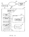
- FIG. 5 is a block diagram illustrating the configuration of the map display system according to Example 2 of the present invention.
- this map display system is configured in an information distribution server 30 and a mobile terminal 10 which can connect to the latter through a network 20 (Internet).
- the information distribution server 30 contains map information.
- a 2-dimensional code 40 established at a specific location, such as a power pole, a sidewalk or the like, is read by the mobile terminal 10, which then receives map information encompassing such location from the information distribution server 30, and displays such information on the display means 18.
- position information latitude and longitude
- azimuth information of that location in relation to the 2-dimensional code read reference orientation are recorded in the 2-dimensional code 40.
- the configuration of the mobile terminal 10 is similar to that of Example 1 ( Figure 3 ), except that it does not hold map information.
- the mobile terminal 10 thus comprises a calculation control unit (CPU) 11, a control memory 12, a storage unit (RAM) 13, a 2-dimensional code reading means 14, a communication unit 15, a power supply unit 16, an operation unit 17 and display means 18.
- the control memory 12 comprises rotation angle calculation means 121 and map rotation means 122.
- the rotation angle calculation means 121 calculates the angle at which the map distributed from the information distribution server 30 should be rotated based on azimuth information of the location in relation to the 2-dimensional code read reference orientation which was read from a 2-dimensional code and the read reference orientation of the 2-dimensional code information, while the map rotation means 122 rotates the map based on the rotation angle calculated by the rotation angle calculation means 121, and the rotated map is displayed on the display means 18.
- Example 2 while a mobile terminal 10 sends position information read from a 2-dimensional code to an information distribution server 30, and receives map information based on such position information coming from the information distribution server 30, whereby the distributed map is displayed on a display means by rotating the map at a rotation angle calculated by the mobile terminal 10, the mobile terminal 10 can also be configured in such manner that it sends position information and a rotation angle to the information distribution server 30, and the map is then rotated by the information distribution server 30 for distribution back to the mobile terminal 10, so that the mobile terminal 10 can display the distributed map on a display means.
- Figure 6 is a diagram illustrating the configuration of the map display system according to Example 3 of the present invention which is configured in this manner.
- the map display system comprises a mobile terminal 10 having a 2-dimensional code reading means 14 for reading a 2-dimensional code 40, and an information distribution server 30 for communicating with the mobile terminal 10 through a network 20.
- the configuration of the mobile terminal 10 is basically the same as that of the mobile terminal 10 of Example 2 (refer to Figure 5 ), except that here, the mobile terminal 10 does not have map rotation means and the information distribution server 30 itself conducts the map rotation.
- the mobile terminal 10 reads a 2-dimensional code 40 and sends the position information recorded in the 2-dimensional code 40 to the information distribution server 30. Furthermore, similar to Examples 1 and 2, the map rotation angle is calculated by the rotation angle calculation means 121, and this rotation angle is sent to the information distribution server 30. The information distribution server 30 then specifies the applicable map information based on the position information received from the mobile terminal 10, rotates the map based on the rotation angle, and distributes the rotated map information to the mobile terminal 10. The mobile terminal 10 thus displays the map on a display means based on such map information received.
- the configuration of the mobile terminal may be such that the 2-dimensional code is recorded with ID information for identifying the 2-dimensional code and position information, each 2-dimensional code being matched with an ID code in an information distribution server, and each 2-dimensional code being recorded with azimuth information of the location in relation to the 2-dimensional code read reference orientation at the particular location, whereby the mobile terminal 10 reads a 2-dimensional code, sends the position information and the ID information to the information distribution server 30, and receives the azimuth information of the location in relation to the 2-dimensional code read reference orientation from the information distribution server 30.
- the map display system according to Example 4 is configured in a mobile terminal 10 comprising 2-dimensional code reading means 14 for reading a 2-dimensional code 40, and an information distribution server 30 for communicating with the mobile terminal 10 through a network 20.
- the 2-dimensional code 40 is recorded with position information of a particular location and ID information for identifying the 2-dimensional code.
- the configuration of the mobile terminal 10 is basically the same as that of the mobile terminal 10 of Example 2 (refer to Figure 5 ), but differs from that of Examples 2 and 3 in that the information distribution server 30 comprises recording means 31 in which each 2-dimensional code is matched with ID information and the azimuth information of a location is recorded in relation to the 2-dimensional code read reference orientation at the location where each 2-dimensional code is established.
- the mobile terminal 10 reads the 2-dimensional code 40 and sends the position information and the ID information recorded in the 2-dimensional code 40 to the information distribution server 30.
- the information distribution server 30 reads out the azimuth information of the location in relation to the read reference orientation of the applicable 2-dimensional code based on the ID information from the recording means 31 and sends the read out azimuth information to the mobile terminal 10.
- the mobile terminal 10 uses this azimuth information to calculate the rotation angle for rotating the map with the rotation angle calculation means 121.
- the map information distributed from the information distribution server 30 is then rotated by the map rotation means 122, and displayed on the display means 18.
- the mobile terminal 10 of Example 4 does not have map rotation means, so that the mobile terminal may be configured in such manner that the rotation angle calculation means 121 sends the calculated rotation angle to the information distribution server 30, and the map is rotated at the information distribution server 30 and sent to the mobile terminal 10 (refer to Figure 6 and Example 3).
- the setting operation of the 2-dimensional code is made easier in the case of the configuration of Example 4.
- Example 4 since the azimuth information of a particular location is recorded in a 2-dimensional code, if the 2-dimensional code is set up facing the wrong direction, modification becomes difficult. For example, if a 2-dimensional code is recorded with reference to a sidewalk tile, the only way to modify or correct this is by replacing the subject tile. In addition, consideration must be made in advance of the tenuousness of the azimuth of a particular location, making such tile production a difficult operation. In contrast, according to the configuration of Example 4, a tile can be laid out correctly by using position information (latitude and longitude) of the location in question.
- each 2-dimensional code is recorded with position information and ID information for identifying the applicable 2-dimensional code, measuring the orientation and actual azimuth of each 2-dimensional code once the laying out is completed, matching such information with the ID information and recording it in the recording means of an information distribution server is made possible. In this manner, the abovementioned difficulties can be minimized. Furthermore, the position information can be directly read from a 2-dimensional code, thereby enabling shared use of services other than map display
- the mobile terminal 10 comprises rotation angle calculation means 121, and is configured in such manner that ID information read from a 2-dimensional code 40 is sent to an information distribution server, whereby azimuth information corresponding to the applicable 2-dimensional code is acquired and a rotation angle for rotating the map is calculated by the rotation angle calculation means 121.
- the rotation angle calculation means is provided in the information distribution server 30, so that the rotation angle for rotating the map is calculated by the information distribution server and is distributed along with map information to the mobile terminal 10, or alternatively, map information which has been rotated based on the calculated rotation angle can be distributed to the mobile terminal 10.
- a 2-dimensional code 40 is recorded with position information of a location where the 2-dimensional code 40 is set up and ID information for identifying the 2-dimensional code 40 in the map display system according to Example 4, another possible configuration is to record only ID information for identifying the 2-dimensional code in the 2-dimensional code 40, whereby each 2-dimensional code is matched with an ID code in an information distribution server, and each 2-dimensional code is recorded with azimuth information of the location in relation to the 2-dimensional code read reference orientation for the locations where each 2-dimensional code has been established, and position information of the set location is also recorded, wherein the mobile terminal 10 reads the 2-dimensional code, sends the ID information to the information distribution server 30, and receives the azimuth information of the location in relation to the 2-dimensional code read reference orientation from the information distribution server 30.
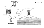
- Figure 8 is a diagram illustrating the configuration of such a map display system, and is configured in such manner that the mobile terminal 10 is a device which is subscribed to a communications service operator, such as an Internet provider or a mobile phone company, wherein the mobile terminal 10 may be connected to an information distribution server 30 through a network 20 (Internet).
- the information distribution server 30 can be any device as long as it contains map information.
- the information distribution server 30 can be an information distribution server established by an Internet provider to provide services, or an information distribution server for providing navigation services, or an information distribution server established by a business or a retail shop etc., or a device which obtains map information from a desired server such as the abovementioned.
- a handheld computer 50 comprises 2-dimensional code reading means, GPS positioning means, an electronic compass and communication means, and has been authenticated with the information distribution server 30 as an information recording terminal.
- the 2-dimensional code 40 is recorded only with ID information used for identification and URL information used for data recording into the information distribution server 30, and is set up at a specific location, such as a sidewalk, wall, power pole or the like.
- ID information of each 2-dimensional code 40 is read by the handheld computer 50, which uses GPS positioning means to request position information (latitude and longitude) of a particular location.
- the electronic compass serves to calculate the azimuth of such location in relation to the 2-dimensional code read reference orientation. This information is sent to the information distribution server 30 using a URL read from the 2-dimensional code 40, and matched with ID information of each 2-dimensional code for recording in the recording means.
- the configuration of this map display system is similar to the configuration illustrated in Figure 7 , wherein the mobile terminal 10 reads a 2-dimensional code 40 which is established at a specific location such as a sidewalk, wall, power pole or the like, and sends the ID information to an information distribution server 30. Based on the ID information contained in the recording means 31, the information distribution server 30 reads out position information corresponding to the 2-dimensional code and azimuth information of the location in question in relation to the 2-dimensional code read reference orientation. The information distribution server 30 sends the read out azimuth information of the location in relation to the 2-dimensional code read reference orientation to the mobile terminal 10, and also specifies the applicable map information based on the position information for distribution to the mobile terminal 10.
- the mobile terminal 10 calculates a rotation angle of the map with the rotation angle calculation means 121 according to azimuth information of the location in relation to the 2-dimensional code read reference orientation sent from the information distribution server 30. Based on the rotation angle calculated by the rotation angle calculation means 121, the map rotation means 122 in the mobile terminal 10 rotates the map information distributed from the information distribution server 30, and the display means 18 displays the rotated map. While rotation of the map in Figure 7 is performed by the mobile terminal 10, rotation of the map may also be carried out by the information distribution server 30.
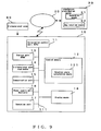
- FIG 9 is a diagram illustrating the configuration of the map display system according to Example 6 of the present invention, which is configured in such manner that rotation of the map is carried out by the information distribution server 30.
- the map display system illustrated in Figure 9 comprises a mobile terminal 10 having 2-dimensional code reading means 14 for reading a 2-dimensional code 40, and an information distribution server 30 for communicating with the mobile terminal 10 through a network 20.
- the configuration of the mobile terminal 10 is basically similar to that of the mobile terminal 10 of Example 2 (refer to Figure 5 ), but differs from that of Figure 7 in that the present mobile terminal 10 is not provided with map rotation means and the information distribution server 30 carries out the map rotation.
- the mobile terminal 10 reads a 2-dimensional code 40 which is established at a specific location, such as a sidewalk, wall, power pole or the like, and sends the ID information to the information distribution server 30. Based on ID information coming from the recording means 31, the information distribution server 30 reads out position information corresponding to the 2-dimensional code and azimuth information of such location in relation to the 2-dimensional code read reference orientation. The information distribution server 30 sends the read out azimuth information of the location in relation to the 2-dimensional code read reference orientation to the mobile terminal 10, and also specifies the applicable map information based on the position information.
- the mobile terminal 10 based on the azimuth information of the location in relation to the 2-dimensional code read reference orientation sent from the information distribution server 30, calculates the rotation angle to which the rotation angle calculation means 121 should rotate the map, and sends the calculated rotation angle to the information distribution server 30.
- the information distribution server 30 uses the map rotation means 122 to rotate the specified map information based on the position information and according to the rotation angle sent from the mobile terminal 10, and distributes the rotated map information to the mobile terminal 10.
- the mobile terminal 10 displays the map information sent from the information distribution server 30 on a display means 18.
- the mobile terminal 10 comprises rotation angle calculation means 121, and is configured in such manner that ID information read from a 2-dimensional code 40 is sent to an information distribution server, whereby the azimuth information corresponding to the applicable 2-dimensional code is acquired for the rotation angle calculation means 121 to calculate the rotation angle for rotating the map.
- the rotation angle calculation means is provided for in the information distribution server 30, so that the rotation angle for rotating the map is calculated by the information distribution server and is distributed along with map information to the mobile terminal 10, or alternatively, map information which has been rotated based on the calculated rotation angle can be distributed to the mobile terminal 10.
- the handheld computer 50 measures information relating to a particular location for each 2-dimensional code 40 in the information distribution server 30 via a network for storing online
- the handheld computer 50 does not have an online communications function, there is no need to record the URL of the information distribution server 30 in the 2-dimensional code 40.
- the configuration can be such that once the handheld computer 50 has finished collecting information, it is connected with a cable to the information distribution server 30 for storing the information of each 2-dimensional code 40 set location.
- the configuration as illustrated in Examples 5 and 6, wherein only ID information is recorded into the 2-dimensional code 40, and position information of a particular location constituting a 2-dimensional code and azimuth information of the location in relation to the 2-dimensional code read reference orientation are matched with the ID information and recorded in the information distribution server, has the following advantages.
- the 2-dimensional code recording medium can be reused at other locations if it is in the form of sheets, and applying or peeling them as may be required, and can be particularly useful in situations such as setting 2-dimensional codes at certain venues for onetime events for distributing venue map guidance.
- the mobile terminal or map display system of the present invention it is possible not only to display a map in accordance with its actual azimuth, but also in an easily understandable orientation.
- the front side of an art gallery, a concert hall, a public building or such other structure need not be oriented to the north, south, east, or west.
- the targeted building was displayed only in a north-up orientation.
- the entrance to a building can also be displayed in a downward-facing orientation by utilizing the azimuth information of the location in relation to the read reference orientation of the corresponding 2-dimensional code.
- Figure 10 is a series of pattern diagrams for explaining usage examples of a map rotation display using a 2-dimensional code, and which illustrates a concert hall and the display thereof, whereby the main entrance of the building is located in the northeast.
- An introductory article about this concert hall and a 2-dimensional code appear in a printed guidebook.
- an ordinary mobile phone or the like equipped with a camera is used to read the 2-dimensional code of the guidebook and its link to the URL which is recorded in this 2-dimensional code.
- Fig. 10(a) shows the display of the map oriented in the normal north-up manner.
- the map to be displayed by the display means would be as shown in Figure 10(c) , wherein the main entrance is facing downward. This confers a sense of reality, giving the viewer the illusion of being in front of the main entrance. If combined with images such as published photographs or the like, guidance which is very easy to understand can be provided.
- the mobile terminal referred to is assumed to be a typical mobile phone equipped with a camera on the side opposite to the main LCD display.
- a mobile phone whose display rotates around the optical axis of the camera e.g., a "revolving type"
- the optical axis of the mobile terminal's camera substantially differs in orientation from that of the main LCD display
- the present invention can obviously be used for providing position information where GPS cannot be used, such as underground shopping areas, building interiors etc., and since the display direction can be determined by associating with the direction of a 2-dimensional code, it is possible to provide an easy to understand guide. Further, by establishing several 2-dimensional codes, it is also possible to provide a walking route guide while updating position information by tracking along the established 2-dimensional codes. For example, by setting up a 2-dimensional code at a corridor intersection of a hospital, the present invention can also be utilized as a system for navigating routes to other places within the hospital, such as the reception area, out-patient clinic, accounting section, visitors' lobby and the like.
Landscapes
- Engineering & Computer Science (AREA)
- Radar, Positioning & Navigation (AREA)
- Remote Sensing (AREA)
- Physics & Mathematics (AREA)
- General Physics & Mathematics (AREA)
- Theoretical Computer Science (AREA)
- Automation & Control Theory (AREA)
- Databases & Information Systems (AREA)
- Mathematical Physics (AREA)
- Business, Economics & Management (AREA)
- Educational Administration (AREA)
- Educational Technology (AREA)
- Computer Networks & Wireless Communication (AREA)
- Signal Processing (AREA)
- Instructional Devices (AREA)
- Navigation (AREA)
- Traffic Control Systems (AREA)
Applications Claiming Priority (2)
| Application Number | Priority Date | Filing Date | Title |
|---|---|---|---|
| JP2004065358A JP4322147B2 (ja) | 2004-03-09 | 2004-03-09 | 地図表示機能を有する携帯端末、地図表示システムおよび情報配信サーバならびにプログラム |
| PCT/JP2005/003540 WO2005086120A1 (ja) | 2004-03-09 | 2005-03-02 | 地図表示機能を有する携帯端末、地図表示システムおよび情報配信サーバならびにプログラム |
Publications (3)
| Publication Number | Publication Date |
|---|---|
| EP1727109A1 EP1727109A1 (en) | 2006-11-29 |
| EP1727109A4 EP1727109A4 (en) | 2010-03-17 |
| EP1727109B1 true EP1727109B1 (en) | 2013-05-01 |
Family
ID=34918238
Family Applications (1)
| Application Number | Title | Priority Date | Filing Date |
|---|---|---|---|
| EP05719855.8A Ceased EP1727109B1 (en) | 2004-03-09 | 2005-03-02 | Mobile terminal having map display function, and map display system with information distribution server |
Country Status (6)
| Country | Link |
|---|---|
| US (1) | US7840343B2 (ko) |
| EP (1) | EP1727109B1 (ko) |
| JP (1) | JP4322147B2 (ko) |
| KR (1) | KR101052675B1 (ko) |
| CN (1) | CN100589153C (ko) |
| WO (1) | WO2005086120A1 (ko) |
Families Citing this family (40)
| Publication number | Priority date | Publication date | Assignee | Title |
|---|---|---|---|---|
| JP4262241B2 (ja) * | 2005-11-30 | 2009-05-13 | 株式会社ナビタイムジャパン | オフライン経路表示システム、携帯端末装置および認識コード生成装置 |
| JP4645432B2 (ja) * | 2005-12-13 | 2011-03-09 | 株式会社デンソー | ナビゲーション装置 |
| US8595648B1 (en) * | 2006-06-28 | 2013-11-26 | West Corporation | Script logic graphical mapping |
| US20080110991A1 (en) * | 2006-11-15 | 2008-05-15 | Bellsouth Intellectual Property Corporation | Apparatus and methods for providing active functions using encoded two-dimensional arrays |
| JP4966630B2 (ja) * | 2006-11-21 | 2012-07-04 | 日本電信電話株式会社 | 位置方向情報表示装置,位置方向情報表示方法,位置方向情報表示プログラム |
| JP4851969B2 (ja) * | 2007-03-13 | 2012-01-11 | 日本電信電話株式会社 | 環状idマーク読み取り装置、環状idマーク読み取りシステム、環状idマーク読み取り方法および環状idマーク読み取りプログラム |
| JP4510857B2 (ja) * | 2007-08-03 | 2010-07-28 | 株式会社三井住友銀行 | 拠点網を活用した経路案内システム及び方法 |
| US20090106095A1 (en) * | 2007-10-22 | 2009-04-23 | Hand Held Products, Inc. | Navigator With Dataform Decoder |
| JP4979622B2 (ja) * | 2008-03-17 | 2012-07-18 | ヤフー株式会社 | 地図画面を提供するサーバ、方法、およびプログラム |
| JP2010028309A (ja) * | 2008-07-16 | 2010-02-04 | Canon Inc | 装置、方法、プログラムおよび記憶媒体 |
| WO2010112625A1 (es) * | 2009-03-31 | 2010-10-07 | Fundacion Fatronik | Método y dispositivo de orientación |
| US8855929B2 (en) * | 2010-01-18 | 2014-10-07 | Qualcomm Incorporated | Using object to align and calibrate inertial navigation system |
| CN101833875B (zh) * | 2010-04-30 | 2012-03-21 | 湖南纽曼数码科技有限公司 | 语音导航点读笔 |
| US9229089B2 (en) | 2010-06-10 | 2016-01-05 | Qualcomm Incorporated | Acquisition of navigation assistance information for a mobile station |
| KR101690594B1 (ko) * | 2010-11-01 | 2016-12-28 | 엘지전자 주식회사 | 전자 기기 및 전자 기기의 제어 방법 |
| US9165334B2 (en) * | 2010-12-28 | 2015-10-20 | Pet Check Technology Llc | Pet and people care management system |
| US10199726B2 (en) | 2011-06-29 | 2019-02-05 | Pismo Labs Technology Limited | Systems and methods providing assisted aiming for wireless links through a plurality of external antennas |
| US9055455B2 (en) * | 2011-06-29 | 2015-06-09 | Pismo Labs Technology Ltd. | Systems and methods providing assisted aiming for wireless links |
| KR101814606B1 (ko) | 2011-10-14 | 2018-01-05 | 삼성전자주식회사 | 기기 제어 방법 및 그 장치 |
| KR20130094947A (ko) * | 2012-02-17 | 2013-08-27 | 삼성전자주식회사 | 무선 액세스포인트 위치 측위 방법 및 장치 |
| KR101952702B1 (ko) * | 2012-06-01 | 2019-02-28 | 삼성전자주식회사 | 개인 정보에 기초한 서비스를 제공하는 사용자 단말 장치 및 그 서비스 제공 방법 |
| US20140209671A1 (en) * | 2013-01-30 | 2014-07-31 | Qualcomm Incorporated | System for Transferring Maps to a Mobile Device Without Network Connectivity Using Matrix Bar Codes or Other Passive Data Media |
| DE102013101493A1 (de) * | 2013-02-14 | 2014-08-14 | Continental Teves Ag & Co. Ohg | Verfahren zum Betreiben eines Navigationssystems eines Fahrzeugs sowie Navigationssystem |
| TWI474294B (zh) * | 2013-05-10 | 2015-02-21 | Univ Yuan Ze | 導航環境之設置方法 |
| WO2014191731A1 (en) * | 2013-05-29 | 2014-12-04 | Bae Systems Plc | Structure navigation |
| EP2808649A1 (en) * | 2013-05-29 | 2014-12-03 | BAE Systems PLC | Structure navigation |
| LU92208B1 (en) * | 2013-06-07 | 2014-12-08 | Andrzej Jaroslaw Galuszka | Mobile phone or portable PC with a camera |
| JP6296056B2 (ja) * | 2013-06-17 | 2018-03-20 | ソニー株式会社 | 画像処理装置、画像処理方法及びプログラム |
| KR102107395B1 (ko) * | 2013-08-28 | 2020-05-07 | 삼성전자주식회사 | 모바일 단말기 및 그의 코드 인식 방법 |
| CN105095805A (zh) * | 2014-05-16 | 2015-11-25 | 北京奇虎科技有限公司 | 定位智能终端设备的方法及系统 |
| JP2016024410A (ja) * | 2014-07-23 | 2016-02-08 | 溝部 達司 | ガイドマップ及び案内支援システム |
| CN105387857A (zh) * | 2015-12-08 | 2016-03-09 | 申志远 | 导航方法及装置 |
| JP2017111034A (ja) * | 2015-12-17 | 2017-06-22 | 株式会社日立ソリューションズ | カメラ付き端末、ナビゲーション情報提供システム、及びナビゲーション情報表示方法 |
| CN105608403B (zh) * | 2016-02-06 | 2018-08-14 | 湖南暴云科技有限公司 | 一种基于二维码定位的方法及系统 |
| CN107976185A (zh) * | 2016-10-25 | 2018-05-01 | 金德奎 | 一种基于二维码、陀螺仪和加速度计的定位系统和定位方法以及信息服务方法 |
| CN106850773A (zh) * | 2017-01-12 | 2017-06-13 | 江苏速度信息科技股份有限公司 | 一种基于二维码的商场室内定位导航的方法及系统 |
| JP6741041B2 (ja) * | 2018-06-20 | 2020-08-19 | 株式会社Jvcケンウッド | 送信制御装置、送信制御方法、送信制御プログラム |
| JP2020112368A (ja) * | 2019-01-08 | 2020-07-27 | 共同紙工株式会社 | 情報提示システム、携帯型情報提示装置、記録媒体及びプログラム |
| WO2020245991A1 (ja) * | 2019-06-06 | 2020-12-10 | マクセル株式会社 | 道案内システム及びそれに用いる携帯情報端末 |
| JP2022093230A (ja) * | 2020-12-11 | 2022-06-23 | 株式会社ダイカン | 地図表示システムおよび地図表示方法 |
Family Cites Families (13)
| Publication number | Priority date | Publication date | Assignee | Title |
|---|---|---|---|---|
| JPH0950481A (ja) * | 1995-08-07 | 1997-02-18 | Mita Ind Co Ltd | 二次元コードの読取装置 |
| JPH10213445A (ja) * | 1996-11-26 | 1998-08-11 | Matsushita Electric Works Ltd | ナビゲーション装置 |
| JP2000222517A (ja) * | 1998-11-27 | 2000-08-11 | Denso Corp | 2次元コ―ド読取方法、2次元コ―ド読取装置及び記録媒体 |
| JP3397170B2 (ja) * | 1999-05-27 | 2003-04-14 | 株式会社デンソー | 情報コードの記録位置検知装置及び光学情報読取装置 |
| JP3986220B2 (ja) * | 1999-10-19 | 2007-10-03 | オリンパス株式会社 | 情報表示部材及びそれを用いた位置検出方法 |
| FR2801158B1 (fr) * | 1999-11-17 | 2002-03-08 | Sagem | Appareil portable comportant des moyens d'orientation procede d'utilisation d'un tel appareil et procede d'orientation correspondant |
| JP2002048586A (ja) * | 2000-07-31 | 2002-02-15 | Takatsugu Kitagawa | ナビゲーション方法、携帯情報機器、ナビゲーション用サーバ、及び光学的データ解析用サーバ |
| JP4923339B2 (ja) * | 2001-06-27 | 2012-04-25 | ソニー株式会社 | 地図表示システム、メモリ装置、情報端末装置、方位情報送出プログラム、地図情報表示プログラム、および、プログラム記録媒体 |
| JP2003319033A (ja) * | 2002-04-18 | 2003-11-07 | Ntt Docomo Inc | 携帯通信端末情報入力システム、携帯通信端末、携帯通信端末用プログラム、解析サーバ、及び、携帯通信端末情報入力方法 |
| JP4153246B2 (ja) * | 2002-06-14 | 2008-09-24 | 日本信号株式会社 | リアルタイム情報を用いた情報提供システム |
| JP2004257872A (ja) * | 2003-02-26 | 2004-09-16 | Seiko Epson Corp | 位置情報取得システム、位置情報取得装置、位置情報取得方法、及びプログラム |
| JP2005291885A (ja) * | 2004-03-31 | 2005-10-20 | Nec Corp | ナビゲーション機能付き携帯通信端末 |
| JP2006170872A (ja) * | 2004-12-17 | 2006-06-29 | Seiko Epson Corp | 誘導情報システム及び携帯機器 |
-
2004
- 2004-03-09 JP JP2004065358A patent/JP4322147B2/ja not_active Expired - Fee Related
-
2005
- 2005-03-02 US US10/592,058 patent/US7840343B2/en not_active Expired - Fee Related
- 2005-03-02 WO PCT/JP2005/003540 patent/WO2005086120A1/ja not_active Application Discontinuation
- 2005-03-02 EP EP05719855.8A patent/EP1727109B1/en not_active Ceased
- 2005-03-02 CN CN200580007683A patent/CN100589153C/zh not_active Expired - Fee Related
- 2005-03-02 KR KR1020067018282A patent/KR101052675B1/ko active IP Right Grant
Also Published As
| Publication number | Publication date |
|---|---|
| CN100589153C (zh) | 2010-02-10 |
| KR101052675B1 (ko) | 2011-07-28 |
| EP1727109A4 (en) | 2010-03-17 |
| JP4322147B2 (ja) | 2009-08-26 |
| US7840343B2 (en) | 2010-11-23 |
| WO2005086120A1 (ja) | 2005-09-15 |
| US20070198180A1 (en) | 2007-08-23 |
| EP1727109A1 (en) | 2006-11-29 |
| JP2005257738A (ja) | 2005-09-22 |
| KR20070018885A (ko) | 2007-02-14 |
| CN1930596A (zh) | 2007-03-14 |
Similar Documents
| Publication | Publication Date | Title |
|---|---|---|
| EP1727109B1 (en) | Mobile terminal having map display function, and map display system with information distribution server | |
| US11776185B2 (en) | Server, user terminal, and service providing method, and control method thereof for displaying photo images within a map | |
| US7088389B2 (en) | System for displaying information in specific region | |
| US20190086214A1 (en) | Image processing device, image processing method, and program | |
| EP1692863B1 (en) | Device, system, method and computer software product for displaying additional information in association with the image of an object | |
| US20020045988A1 (en) | Spatial information using system, system for obtaining information, and server system | |
| US20030202104A1 (en) | Location-based services for photography | |
| CN102006548A (zh) | 信息提供方法、设备和系统、信息显示方法和移动终端 | |
| CN101573588A (zh) | 位置立标和定向 | |
| EP1580977A2 (en) | Method of managing and viewing image data | |
| CN103563404A (zh) | 用于收集并提供地图图像的系统和方法 | |
| JP7465856B2 (ja) | サーバ、端末、配信システム、配信方法、情報処理方法、およびプログラム | |
| GB2421653A (en) | System for the collection and association of image and position data | |
| JP2001118187A (ja) | 情報表示部材及びそれを用いた位置検出方法 | |
| JP4926189B2 (ja) | 二次元コード記録体の設置方法 | |
| US9354076B2 (en) | Guiding server, guiding method and recording medium recording guiding program | |
| JP2006184235A (ja) | 地域案内システム | |
| WO2021256239A1 (ja) | ナビゲーション装置、ナビゲーションシステム、ナビゲーション方法、プログラム、及び、記録媒体 | |
| US8335523B2 (en) | Electronic entity and microcircuit card for electronic entity | |
| JP2008058267A (ja) | 情報提供システム、及び情報提供方法 | |
| JP2004140658A (ja) | 情報処理装置、位置情報利用システム、および画像管理方法 | |
| JP4340555B2 (ja) | コード札 | |
| JP2013205465A (ja) | 地図情報表示システム | |
| JP2003308326A (ja) | 情報処理装置、位置情報利用システム、および画像管理方法 | |
| JP2003224877A (ja) | 携帯型情報装置、外部装置、情報提供装置、位置情報利用システム、および位置情報利用方法 |
Legal Events
| Date | Code | Title | Description |
|---|---|---|---|
| PUAI | Public reference made under article 153(3) epc to a published international application that has entered the european phase |
Free format text: ORIGINAL CODE: 0009012 |
|
| 17P | Request for examination filed |
Effective date: 20060907 |
|
| AK | Designated contracting states |
Kind code of ref document: A1 Designated state(s): DE FR GB |
|
| DAX | Request for extension of the european patent (deleted) | ||
| RBV | Designated contracting states (corrected) |
Designated state(s): DE FR GB |
|
| A4 | Supplementary search report drawn up and despatched |
Effective date: 20100217 |
|
| 17Q | First examination report despatched |
Effective date: 20100602 |
|
| REG | Reference to a national code |
Ref country code: DE Ref legal event code: R079 Ref document number: 602005039358 Country of ref document: DE Free format text: PREVIOUS MAIN CLASS: G09B0029000000 Ipc: G01C0021000000 |
|
| RIC1 | Information provided on ipc code assigned before grant |
Ipc: G08G 1/0969 20060101ALI20120712BHEP Ipc: G08G 1/0968 20060101ALI20120712BHEP Ipc: G09B 29/10 20060101ALI20120712BHEP Ipc: G08G 1/005 20060101ALI20120712BHEP Ipc: G01C 21/00 20060101AFI20120712BHEP Ipc: G01C 21/20 20060101ALI20120712BHEP |
|
| GRAP | Despatch of communication of intention to grant a patent |
Free format text: ORIGINAL CODE: EPIDOSNIGR1 |
|
| RIN1 | Information on inventor provided before grant (corrected) |
Inventor name: SAKAMOTO, HIROSHI |
|
| GRAS | Grant fee paid |
Free format text: ORIGINAL CODE: EPIDOSNIGR3 |
|
| GRAA | (expected) grant |
Free format text: ORIGINAL CODE: 0009210 |
|
| AK | Designated contracting states |
Kind code of ref document: B1 Designated state(s): DE FR GB |
|
| REG | Reference to a national code |
Ref country code: GB Ref legal event code: FG4D |
|
| REG | Reference to a national code |
Ref country code: DE Ref legal event code: R096 Ref document number: 602005039358 Country of ref document: DE Effective date: 20130627 |
|
| PLBE | No opposition filed within time limit |
Free format text: ORIGINAL CODE: 0009261 |
|
| STAA | Information on the status of an ep patent application or granted ep patent |
Free format text: STATUS: NO OPPOSITION FILED WITHIN TIME LIMIT |
|
| 26N | No opposition filed |
Effective date: 20140204 |
|
| REG | Reference to a national code |
Ref country code: DE Ref legal event code: R097 Ref document number: 602005039358 Country of ref document: DE Effective date: 20140204 |
|
| REG | Reference to a national code |
Ref country code: FR Ref legal event code: PLFP Year of fee payment: 12 |
|
| REG | Reference to a national code |
Ref country code: FR Ref legal event code: PLFP Year of fee payment: 13 |
|
| PGFP | Annual fee paid to national office [announced via postgrant information from national office to epo] |
Ref country code: DE Payment date: 20170322 Year of fee payment: 13 Ref country code: FR Payment date: 20170322 Year of fee payment: 13 |
|
| PGFP | Annual fee paid to national office [announced via postgrant information from national office to epo] |
Ref country code: GB Payment date: 20170322 Year of fee payment: 13 |
|
| REG | Reference to a national code |
Ref country code: DE Ref legal event code: R119 Ref document number: 602005039358 Country of ref document: DE |
|
| GBPC | Gb: european patent ceased through non-payment of renewal fee |
Effective date: 20180302 |
|
| PG25 | Lapsed in a contracting state [announced via postgrant information from national office to epo] |
Ref country code: DE Free format text: LAPSE BECAUSE OF NON-PAYMENT OF DUE FEES Effective date: 20181002 |
|
| PG25 | Lapsed in a contracting state [announced via postgrant information from national office to epo] |
Ref country code: GB Free format text: LAPSE BECAUSE OF NON-PAYMENT OF DUE FEES Effective date: 20180302 |
|
| PG25 | Lapsed in a contracting state [announced via postgrant information from national office to epo] |
Ref country code: FR Free format text: LAPSE BECAUSE OF NON-PAYMENT OF DUE FEES Effective date: 20180331 |