EP1287513B1 - Navigationsverfahren - Google Patents
Navigationsverfahren Download PDFInfo
- Publication number
- EP1287513B1 EP1287513B1 EP01940227A EP01940227A EP1287513B1 EP 1287513 B1 EP1287513 B1 EP 1287513B1 EP 01940227 A EP01940227 A EP 01940227A EP 01940227 A EP01940227 A EP 01940227A EP 1287513 B1 EP1287513 B1 EP 1287513B1
- Authority
- EP
- European Patent Office
- Prior art keywords
- navigation
- destination
- parking location
- vehicle
- data
- Prior art date
- Legal status (The legal status is an assumption and is not a legal conclusion. Google has not performed a legal analysis and makes no representation as to the accuracy of the status listed.)
- Expired - Lifetime
Links
Images
Classifications
-
- G—PHYSICS
- G08—SIGNALLING
- G08G—TRAFFIC CONTROL SYSTEMS
- G08G1/00—Traffic control systems for road vehicles
- G08G1/09—Arrangements for giving variable traffic instructions
- G08G1/0962—Arrangements for giving variable traffic instructions having an indicator mounted inside the vehicle, e.g. giving voice messages
- G08G1/0968—Systems involving transmission of navigation instructions to the vehicle
- G08G1/096805—Systems involving transmission of navigation instructions to the vehicle where the transmitted instructions are used to compute a route
- G08G1/096827—Systems involving transmission of navigation instructions to the vehicle where the transmitted instructions are used to compute a route where the route is computed onboard
-
- G—PHYSICS
- G01—MEASURING; TESTING
- G01C—MEASURING DISTANCES, LEVELS OR BEARINGS; SURVEYING; NAVIGATION; GYROSCOPIC INSTRUMENTS; PHOTOGRAMMETRY OR VIDEOGRAMMETRY
- G01C21/00—Navigation; Navigational instruments not provided for in groups G01C1/00 - G01C19/00
- G01C21/26—Navigation; Navigational instruments not provided for in groups G01C1/00 - G01C19/00 specially adapted for navigation in a road network
- G01C21/34—Route searching; Route guidance
- G01C21/3407—Route searching; Route guidance specially adapted for specific applications
- G01C21/3423—Multimodal routing, i.e. combining two or more modes of transportation, where the modes can be any of, e.g. driving, walking, cycling, public transport
-
- G—PHYSICS
- G01—MEASURING; TESTING
- G01C—MEASURING DISTANCES, LEVELS OR BEARINGS; SURVEYING; NAVIGATION; GYROSCOPIC INSTRUMENTS; PHOTOGRAMMETRY OR VIDEOGRAMMETRY
- G01C21/00—Navigation; Navigational instruments not provided for in groups G01C1/00 - G01C19/00
- G01C21/26—Navigation; Navigational instruments not provided for in groups G01C1/00 - G01C19/00 specially adapted for navigation in a road network
- G01C21/34—Route searching; Route guidance
- G01C21/36—Input/output arrangements for on-board computers
- G01C21/3679—Retrieval, searching and output of POI information, e.g. hotels, restaurants, shops, filling stations, parking facilities
- G01C21/3685—Retrieval, searching and output of POI information, e.g. hotels, restaurants, shops, filling stations, parking facilities the POI's being parking facilities
-
- G—PHYSICS
- G01—MEASURING; TESTING
- G01C—MEASURING DISTANCES, LEVELS OR BEARINGS; SURVEYING; NAVIGATION; GYROSCOPIC INSTRUMENTS; PHOTOGRAMMETRY OR VIDEOGRAMMETRY
- G01C21/00—Navigation; Navigational instruments not provided for in groups G01C1/00 - G01C19/00
- G01C21/26—Navigation; Navigational instruments not provided for in groups G01C1/00 - G01C19/00 specially adapted for navigation in a road network
- G01C21/34—Route searching; Route guidance
- G01C21/36—Input/output arrangements for on-board computers
- G01C21/3688—Systems comprising multiple parts or multiple output devices (not client-server), e.g. detachable faceplates, key fobs or multiple output screens
-
- G—PHYSICS
- G08—SIGNALLING
- G08G—TRAFFIC CONTROL SYSTEMS
- G08G1/00—Traffic control systems for road vehicles
- G08G1/09—Arrangements for giving variable traffic instructions
- G08G1/0962—Arrangements for giving variable traffic instructions having an indicator mounted inside the vehicle, e.g. giving voice messages
- G08G1/0968—Systems involving transmission of navigation instructions to the vehicle
- G08G1/096855—Systems involving transmission of navigation instructions to the vehicle where the output is provided in a suitable form to the driver
- G08G1/096861—Systems involving transmission of navigation instructions to the vehicle where the output is provided in a suitable form to the driver where the immediate route instructions are output to the driver, e.g. arrow signs for next turn
-
- G—PHYSICS
- G08—SIGNALLING
- G08G—TRAFFIC CONTROL SYSTEMS
- G08G1/00—Traffic control systems for road vehicles
- G08G1/09—Arrangements for giving variable traffic instructions
- G08G1/0962—Arrangements for giving variable traffic instructions having an indicator mounted inside the vehicle, e.g. giving voice messages
- G08G1/0968—Systems involving transmission of navigation instructions to the vehicle
- G08G1/096855—Systems involving transmission of navigation instructions to the vehicle where the output is provided in a suitable form to the driver
- G08G1/096866—Systems involving transmission of navigation instructions to the vehicle where the output is provided in a suitable form to the driver where the complete route is shown to the driver
-
- G—PHYSICS
- G08—SIGNALLING
- G08G—TRAFFIC CONTROL SYSTEMS
- G08G1/00—Traffic control systems for road vehicles
- G08G1/09—Arrangements for giving variable traffic instructions
- G08G1/0962—Arrangements for giving variable traffic instructions having an indicator mounted inside the vehicle, e.g. giving voice messages
- G08G1/0968—Systems involving transmission of navigation instructions to the vehicle
- G08G1/096855—Systems involving transmission of navigation instructions to the vehicle where the output is provided in a suitable form to the driver
- G08G1/096872—Systems involving transmission of navigation instructions to the vehicle where the output is provided in a suitable form to the driver where instructions are given per voice
Definitions
- the invention relates to a navigation method in which a Vehicle using a navigation system with a vehicle-mounted navigation device to one from one Destination is distant vehicle parking space is moved. It affects furthermore a navigation device and a navigation aid to carry out the procedure.
- a motor vehicle-bound navigation system which from a navigation computer bound to a motor vehicle and a portable device, the portable Device essentially consists of a GPS receiver, one GSM interface and a display unit is built.
- the GSM interface stands with the portable device motor vehicle-bound navigation computer in constant connection, and thus enables use of the vehicle-bound Navigation computer also outside the vehicle.
- the disadvantage of the proposed method is that the navigation computer must always be operated in the vehicle and thus The vehicle's battery is consumed at any time to enable the portable device to be accessed.
- the publication DE 199 23 750 (BRUST HANS DETLEF) deals finding a parked vehicle, after the vehicle user has moved away from it.
- the mobile terminal presented essentially comprises one Data collection unit for the position of the parked vehicle. After removing it from the vehicle, the terminal can Then display the position of the vehicle.
- a disadvantage of the navigation system known from the prior art with a vehicle-mounted navigation device and a portable unit becomes apparent when that Vehicle - as described at the beginning - to one of one Destination is distant vehicle parking space is moved. This is among others inevitably the case when the actual Destination for traffic or parking reasons cannot be started directly with the vehicle, for example because the destination is in an extensive pedestrian zone located. The user must then switch on his vehicle park a parking lot and from the parking lot to the destination By foot or with an alternative means of transport. For this last distance between the vehicle parking location and the destination no help from the portable unit is possible.
- This object is achieved in that at least position data the vehicle parking location and the destination from the navigation system to a vehicle-independent, portable navigation aid are transmitted, which is by means of an output device to a user information about the path between the vehicle parking location and the destination.
- the search for the optimal route between the vehicle parking location and The destination is determined by the navigation aid based on the transmitted Data carried out.
- position data of the vehicle parking location and the destination it can be either addresses or coordinates in a standardized, i.e. H. from the navigation system and from the navigation aid act, coordinate system used.
- Navigation system to the navigation aid not only the Pass position data, but also environmental information for a whole surrounding area around the vehicle parking place, the destination and an intermediate path. That is, it an entire map or a map section for the Area between vehicle parking location and destination transmitted.
- the transmission of the data from the navigation system to the navigation aid is preferably carried out directly from the vehicle-bound Navigation device via a suitable Interface.
- a suitable Interface is preferably a wireless one Interface, e.g. B. an infrared, ultrasound or Radio interface used.
- IrDa infrared
- DECT digital cellular phone
- Bluetooth wireless fidelity
- the position data are obtained using a data carrier, for example with a CompactFlash or MultiMediaCard data carrier or a SIM card etc. , transfer. That is, the position data and / or the environmental information and / or the route data are based on the vehicle-mounted navigation device written a disk and then after removing the disk out of the navigation device and insert it into the Navigation aid read from navigation aid.
- a data carrier for example with a CompactFlash or MultiMediaCard data carrier or a SIM card etc.
- the position data from the navigation device to one Written disk that already has environmental information within a certain range around each Vehicle storage location are stored. It can do this for example, a data carrier, which for example a certain map of a certain area contains.
- the position data and the required environmental information are then from the navigation aid from Read disk.
- the navigation aid a whole set of disks with different cards belong. Depending on the vehicle parking location, the navigation system then inserting a disk with a specific one Card requested and on this card on disk the locations and possibly the optimal route are saved. The navigation aid then uses the data from the stored map and that of the navigation device stored positions and route information to the desired Output information to the user on the way.
- the Position data not from the navigation device itself, but from a data transmission device of the navigation system, for example via a gateway server to which Navigational aid transmitted.
- a transmission can preferably, for example, over long-range radio links in a cellular standard. It offers the information in the form of an SMS or similar Deliver voice message as such SMS messages are relatively inexpensive.
- a suitable navigation device for a vehicle Implementation of the method according to the invention has means to determine the position data of a selected vehicle parking location and a selected destination and / or associated Information about the surroundings of these places or a route between these places.
- this navigation device has an interface for the transmission of the position data or the environmental information and / or the route to a navigation aid and alternatively or additionally a data carrier writing device for storing said Data on a data carrier.
- a navigation aid according to the invention for implementation accordingly has a suitable interface and alternatively or additionally a data carrier reading device.
- the navigation aid is also required an output unit and means for receiving Data regarding a vehicle parking location and a destination from a navigation system using the interface or for collecting such data from a data carrier, and further Means for outputting information about a path between the vehicle parking location and the destination by means of the output unit to a user.
- the output unit is preferably a Display device, for example a display of any kind Size, as well as means of displaying a map based the position data and the environmental information on it Output unit. This means that it will be on the output unit Map with the vehicle parking location marked therein, the destination and marked an optimal way so that the user based on this map with the marked route slightly from Vehicle parking can get to the destination.
- the card With smaller displays, it is also advisable to always use the card to show only in sections, that is, initially only the vehicle parking location with a path towards the destination. The user can then, for example via the softkey buttons, the clipping area towards the path as needed move it until it reaches the destination.
- acoustic signals can be received from the navigation aid Information is given to the user.
- the entire Information only acoustically, e.g. as voice instructions, issue.
- Navigation aid simply a mobile device, a PDA (Organizer) or similar.
- PDA Packer
- Such hand-held Electronic devices usually already have suitable ones Interfaces as well as a display and a keyboard on so that just another additional function to the invention Use of the device must be implemented.
- Implementing Such a function can easily be achieved by means of suitable Software.
- a larger portable device like a laptop or to use the same as a navigation aid.
- the handling of such larger devices is somewhat more cumbersome than with small devices such as mobile phones or PDAs.
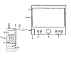
- the navigation aid 5 then shows this map on one Display 6 for the user and provides additional language information if necessary via a loudspeaker 7 so that the user can also be guided acoustically along the way.
- the navigation aid device shown here only schematically 5 can be, for example, a mobile radio device or trade a PDA.
- Such devices have in the Usually a display and a speaker for a suitable one anyway Output of the information on. They also have Devices usually already have a suitable interface for communication with other devices.
- a Bluetooth module 8 In the present Case is a Bluetooth module 8. Accordingly the navigation device 1 is also in the vehicle a Bluetooth module 3, so that this short-range radio standard transmits the required data become.
- FIG. 2 A second alternative is shown in Figure 2.
- the transmission also takes place here via the Bluetooth modules 3, 8.
- a memory 9 in Navigation aid 5 are already different "Map sections" or an overall map for certain areas, for example Germany or Europe, and / or z. B. different city maps saved.
- the appropriate card is then selected or a suitable one Map section selected.
- the "route finder" in the navigation aid 5 located at this Embodiment also the "route finder" in the navigation aid 5. That is, the navigation aid device 5 searches even the optimal route between the vehicle parking location and the destination.
- the "route finder" is here as a route finder module 10 shown.
- the navigation aid 5 can be a mobile radio device or trade a PDA since these devices have storage space anyway and corresponding routefinder modules themselves can also be easily implemented as software.
- the data can be transferred via this interface in Otherwise - in a very comfortable embodiment - automatically when parking the vehicle, for example when Switch off the ignition or remove the ignition key happen. That is, in such a case, for example in the navigation device 1 of the vehicle Start specified only the destination. The navigation device will then direct the driver to the nearest parking lot or the driver automatically places his vehicle on one suitable parking near the indicated destination. When the ignition is switched off, the remaining distance between the automatically determined vehicle location, which the Vehicle parking location corresponds, and the destination together with the appropriate map section to the navigation aid 5 transmitted and shown there on the display 6 for the user.
- a data carrier writing device 4 In the third exemplary embodiment according to FIG Navigation device 1 in the vehicle instead of the Bluetooth module 3 a data carrier writing device 4.
- the position data a data carrier 12, for example a SIM card or a CompactFlash or MultiMediaCard media written.
- a data carrier 12 on which the data for a Map of the corresponding area are included This means, for example, there is an entire library of data carriers, where each disk has a specific map area covers. For example, a disk contains one City map of the greater Kunststoff area, another data carrier one City map of the greater Hamburg area, a data carrier a map of northern Germany and a disk a map of Southern Germany etc.
- the appropriate data carrier is from the navigation device requested and inserted by the user.
- This data carrier 12 is then used by a navigation aid 5 with a suitable data carrier reading device 11 read out, in the present embodiment by the navigation aid 5 immediately based on the position data suitable map section is selected and then only the to the position data of the vehicle parking location and the destination suitable environment information can be read UI. By limiting it to the data that is really needed the reading speed can be increased.
- the position data can in principle be addresses, deal with postcode, town, street and house number. It can but also about coordinates of a standardized coordinate system act with both the navigation system as the navigation aid 5 also works. Preferably acts regardless of the exact data, however, it is cross-system Data formats so that the largest possible Compatibility is guaranteed. When passing addresses can use the vCard or iCard format, for example become.
Abstract
Description
Claims (12)
- Navigationsverfahren, bei dem ein Fahrzeug unter Nutzung eines Navigationssystems mit einer fahrzeuggebundenen Navigationseinrichtung (1) zu einem von einem Zielort beabstandeten Fahrzeugabstellort bewegt wird, dadurch gekennzeichnet, dass zumindest Positionsdaten (PD) des Fahrzeugabstellorts und des Zielorts vom Navigationssystem an ein fahrzeugunabhängiges, portables Navigationshilfegerät (5) übermittelt werden, welches einen Weg zwischen dem Fahrzeugabstellort und dem Zielort ermittelt und mittels einer Ausgabeeinrichtung (6, 7) an einen Benutzer Informationen über diesen Weg ausgibt.
- Navigationsverfahren nach Anspruch 1, dadurch gekennzeichnet, dass vom Navigationssystem an das Navigationshilfegerät (5) Umgebungsinformationen (UI) für einen Umgebungsbereich um den Fahrzeugabstellort, den Zielort und einen dazwischenliegenden Weg übermittelt werden.
- Navigationsverfahren nach Anspruch 1, dadurch gekennzeichnet, dass im Navigationshilfegerät (5) Umgebungsinformationen für Umgebungen verschiedener Orte in einem Speicher (9) hinterlegt sind und anhand der vom Navigationssystem erhaltenen Positionsdaten (PD) des Fahrzeugabstellorts und des Zielorts das Navigationshilfegerät (5) einen Umgebungsbereich um den Fahrzeugabstellort, um den Zielort und einen dazwischenliegenden Weg auswählt.
- Navigationsverfahren nach einem der Ansprüche 1 bis 3, dadurch gekennzeichnet, dass die Positionsdaten (PD) und/oder Umgebungsinformationen (UI) von der fahrzeuggebundenen Navigationseinrichtung (1) über eine Schnittstelle (3, 8) an das Navigationshilfegerät (5) übermittelt werden.
- Navigationsverfahren nach Anspruch 4, dadurch gekennzeichnet, dass die Schnittstelle (3, 8) eine drahtlose Schnittstelle (3, 8) ist.
- Navigationsverfahren nach einem der Ansprüche 1 bis 3, dadurch gekennzeichnet, dass die Positionsdaten und/oder die Umgebungsinformationen und/oder die Wegdaten von der fahrzeuggebundenen Navigationseinrichtung auf einen Datenträger geschrieben werden und von dem Navigationshilfegerät vom Datenträger gelesen werden.
- Navigationsverfahren nach Anspruch 6, dadurch gekennzeichnet, dass die Positionsdaten (PD) von der fahrzeuggebundenen Navigationseinrichtung (5) auf einen Datenträger (12) geschrieben werden, auf dem Umgebungsinformationen (UI) innerhalb eines bestimmten Bereichs um den Fahrzeugabstellort gespeichert sind, und die Positionsdaten (PD) und Umgebungsinformationen (UI) von dem Navigationshilfegerät (5) vom Datenträger (12) gelesen werden.
- Navigationsverfahren nach einem der Ansprüche 1 bis 3, dadurch gekennzeichnet, dass die Positionsdaten und/oder Umgebungsinformationen von einer Datenübermittlungseinrichtung des Navigationssystems an das Navigationshilfegerät übermittelt werden.
- Navigationseinrichtung (1) für ein Fahrzeug zur Durchführung eines Verfahrens nach einem der Ansprüche 1 bis 8, mit Mitteln zur Ermittlung der Positionsdaten (PD) eines gewählten Fahrzeugabstellorts und eines gewählten Zielorts und/oder zugehöriger Umgebungsinformationen (UI) dieser Orte und eines Weges zwischen diesen Orten, und
mit einer Schnittstelle (3) zur Übermittlung der Positionsdaten (PD) und/oder der Umgebungsinformationen (UI) an ein portables Navigationshilfegerät (5) und/oder einer Datenträgerschreibeinrichtung (4) zur Speicherung der Positionsdaten (PD) und/oder der Umgebungsinformationen (UI) auf einem Datenträger (12), wobei das Navigationshilfsgerät (5) Mittel zur Bestimmung des Weges zwischen dem Fahrzeugabstellort und dem Zielort umfasst. - Portables Navigationshilfegerät (5) zur Durchführung eines Verfahrens nach einem der Ansprüche 1 bis 8, mit Mitteln zur Bestimmung des Weges zwischen dem Fahrzeugabstellort und dem Zielort, mit einer Schnittstelle (8) und/oder einer Datenträgerleseeinrichtung (11) und mit einer Ausgabeeinheit (6, 7) und mit Mitteln zum Empfang von Daten betreffend einen Fahrzeugabstellort und einen Zielort von einem Navigationssystem mittels der Schnittstelle (8) und/oder zum Erfassen solcher Daten von einem Datenträger (12) und zur Ausgabe von Informationen über einen Weg zwischen dem Fahrzeugabstellort und dem zielort mittels der Ausgabeeinheit (6, 7) an einen Benutzer.
- Navigationshilfegerät nach Anspruch 10, dadurch gekennzeichnet, dass die Ausgabeeinheit (6, 7) eine Anzeigeeinrichtung (6) umfasst und das Navigationshilfegerät (5) Mittel zur Darstellung einer Karte auf Grundlage der Positionsdaten (PD) und der Umgebungsinformationen (UI) auf der Ausgabeeinheit (6) aufweist.
- Navigationshilfegerät nach Anspruch 10 oder 11, dadurch gekennzeichnet, dass das Navigationshilfegerät ein Mobilfunkgerät und/oder PDA umfasst.
Applications Claiming Priority (3)
| Application Number | Priority Date | Filing Date | Title |
|---|---|---|---|
| DE10024475 | 2000-05-18 | ||
| DE10024475 | 2000-05-18 | ||
| PCT/DE2001/001783 WO2001088877A1 (de) | 2000-05-18 | 2001-05-10 | Navigationsverfahren |
Publications (2)
| Publication Number | Publication Date |
|---|---|
| EP1287513A1 EP1287513A1 (de) | 2003-03-05 |
| EP1287513B1 true EP1287513B1 (de) | 2004-09-29 |
Family
ID=7642599
Family Applications (1)
| Application Number | Title | Priority Date | Filing Date |
|---|---|---|---|
| EP01940227A Expired - Lifetime EP1287513B1 (de) | 2000-05-18 | 2001-05-10 | Navigationsverfahren |
Country Status (3)
| Country | Link |
|---|---|
| EP (1) | EP1287513B1 (de) |
| DE (1) | DE50103892D1 (de) |
| WO (1) | WO2001088877A1 (de) |
Cited By (1)
| Publication number | Priority date | Publication date | Assignee | Title |
|---|---|---|---|---|
| DE102006054346A1 (de) * | 2006-11-17 | 2008-05-21 | Conti Temic Microelectronic Gmbh | Navigationsgerät und Verfahren zur Bestimmung der geographischen Position eines Fahrzeugs |
Families Citing this family (9)
| Publication number | Priority date | Publication date | Assignee | Title |
|---|---|---|---|---|
| WO2004094953A1 (de) * | 2003-04-17 | 2004-11-04 | Atx Europe Gmbh | Verfahren zur fahrroutenplanung |
| DE10327952A1 (de) * | 2003-06-20 | 2005-01-05 | Harman Becker Automotive Systems Gmbh | Navigationssystem |
| US20050060118A1 (en) * | 2003-09-11 | 2005-03-17 | Nokia Corporation | Terminal and an associated system, method and computer program product for obtaining the terminal location based upon connections of the terminal |
| DE102007046317A1 (de) * | 2007-09-27 | 2009-04-02 | Robert Bosch Gmbh | Navigationssystem |
| DE102008032637A1 (de) * | 2008-07-11 | 2010-01-21 | Navigon Ag | Verfahren zum Betrieb eines Navigationsgeräts |
| JP2010060400A (ja) * | 2008-09-03 | 2010-03-18 | Sony Corp | ナビゲーション装置、ナビゲーション装置の表示方法、ナビゲーション装置の表示方法のプログラム及びナビゲーション装置の表示方法のプログラムを記録した記録媒体 |
| US8914229B2 (en) * | 2013-03-15 | 2014-12-16 | Google Inc. | Systems and methods for transferring navigation data |
| DE102014013207A1 (de) * | 2014-09-06 | 2015-08-27 | Audi Ag | Verfahren zur Navigation eines Benutzers zwischen einer ersten Position innerhalb eines Gebäudebereichs und einer zweiten Position |
| CN104880195A (zh) * | 2015-06-02 | 2015-09-02 | 瑞声声学科技(深圳)有限公司 | 移动通信导航终端及其导航方法 |
Family Cites Families (6)
| Publication number | Priority date | Publication date | Assignee | Title |
|---|---|---|---|---|
| DE19521929A1 (de) * | 1994-10-07 | 1996-04-11 | Mannesmann Ag | Einrichtung zur Zielführung von Personen |
| JP3893647B2 (ja) * | 1996-09-30 | 2007-03-14 | マツダ株式会社 | ナビゲーション装置 |
| JPH10103990A (ja) * | 1996-09-30 | 1998-04-24 | Mazda Motor Corp | 移動体通信システム |
| ATE288115T1 (de) * | 1998-05-22 | 2005-02-15 | Hans-Detlef Brust | Vorrichtung und verfahren zum auffinden eines geparkten fahrzeugs |
| DE19828077A1 (de) * | 1998-06-24 | 1999-12-30 | Bosch Gmbh Robert | Navigationssystem für ein Fortbewegungsmittel |
| DE19848192A1 (de) * | 1998-10-20 | 2000-04-27 | Volkswagen Ag | Navigationseinrichtung insbesondere für ein Kraftfahrzeug |
-
2001
- 2001-05-10 WO PCT/DE2001/001783 patent/WO2001088877A1/de active IP Right Grant
- 2001-05-10 DE DE50103892T patent/DE50103892D1/de not_active Expired - Lifetime
- 2001-05-10 EP EP01940227A patent/EP1287513B1/de not_active Expired - Lifetime
Cited By (1)
| Publication number | Priority date | Publication date | Assignee | Title |
|---|---|---|---|---|
| DE102006054346A1 (de) * | 2006-11-17 | 2008-05-21 | Conti Temic Microelectronic Gmbh | Navigationsgerät und Verfahren zur Bestimmung der geographischen Position eines Fahrzeugs |
Also Published As
| Publication number | Publication date |
|---|---|
| DE50103892D1 (de) | 2004-11-04 |
| EP1287513A1 (de) | 2003-03-05 |
| WO2001088877A1 (de) | 2001-11-22 |
Similar Documents
| Publication | Publication Date | Title |
|---|---|---|
| DE602004003789T2 (de) | Verfahren zur Eingabe von Zielortinformationen über ein mobiles Endgerät | |
| DE60212278T2 (de) | System und Verfahren zur Integration von teilnehmerbasierten Navigationsdaten und Unterkunftsdaten mit GPS-Daten | |
| EP0697580B1 (de) | Navigationssystem für ein Fahrzeug | |
| DE69531248T2 (de) | Intelligentes zielführungssystem für fahrzeuge | |
| DE69726662T2 (de) | Landfahrzeugsnavigationsgerät mit lokaler Routenführungsselektivität und Speichermedium dafür | |
| DE60010080T2 (de) | Tragbares informationsgerät für fahrer | |
| EP0805952B1 (de) | Einrichtung zur zielführung von personen | |
| EP1198696B1 (de) | Verfahren und vorrichtung zur übermittlung von navigations-informationen von einer datenzentrale an ein fahrzeug-basiertes navigationssystem | |
| DE112005000605T5 (de) | Navigationsvorrichtung, die dynamische Reiseinformationen anzeigt | |
| DE19808802A1 (de) | Kraftfahrzeugnavigationssystem | |
| WO2000034933A1 (de) | Vorrichtung und verfahren zum auffinden eines geparkten fahrzeugs | |
| EP1800274B1 (de) | Portabler computer für navigationsaufgaben | |
| DE112009004311T5 (de) | Verfahren und Vorrichtung zur Bereitstellung einer Navigationszusammenfassung | |
| EP1287513B1 (de) | Navigationsverfahren | |
| EP1133675B1 (de) | Navigationsgerät und navigationsverfahren | |
| DE60316536T2 (de) | Datenbanksystem für eine Navigationsvorrichtung | |
| DE19521917C2 (de) | Verfahren und Vorrichtung zur Positionsbestimmung eines Fahrzeugs | |
| WO2002037446A1 (de) | Verfahren zur navigation und vorrichtung zu dessen durchführung | |
| EP1038282A2 (de) | Navigationssystem für ein fortbewegungsmittel | |
| DE102010056404A1 (de) | Heruntergeladene Ziele und Schnittstelle für mehrere fahrzeuginterne Navigationseinrichtungen | |
| WO2005083362A1 (de) | Navigationssystem | |
| DE102005061698B4 (de) | Verfahren zum automatischen Eintrag in ein Adressbuch | |
| WO2007025717A1 (de) | Kommunikationssystem zur datenübertragung zwischen einem fahrzeug und einem ausserhalb des fahrzeugs befindlichen mobilfunkgerät | |
| EP1376991B1 (de) | Vorrichtung zur Datenübertragung zwischen einem Fahrzeug und einem mobilen Endgerät | |
| DE19947790A1 (de) | Navigationssystem mit automatischem Datenträgerwechsel |
Legal Events
| Date | Code | Title | Description |
|---|---|---|---|
| PUAI | Public reference made under article 153(3) epc to a published international application that has entered the european phase |
Free format text: ORIGINAL CODE: 0009012 |
|
| 17P | Request for examination filed |
Effective date: 20021105 |
|
| AK | Designated contracting states |
Kind code of ref document: A1 Designated state(s): AT BE CH CY DE DK ES FI FR GB GR IE IT LI LU MC NL PT SE TR |
|
| RIN1 | Information on inventor provided before grant (corrected) |
Inventor name: ZECHLIN, OLIVER |
|
| 17Q | First examination report despatched |
Effective date: 20030507 |
|
| GRAP | Despatch of communication of intention to grant a patent |
Free format text: ORIGINAL CODE: EPIDOSNIGR1 |
|
| GRAS | Grant fee paid |
Free format text: ORIGINAL CODE: EPIDOSNIGR3 |
|
| GRAA | (expected) grant |
Free format text: ORIGINAL CODE: 0009210 |
|
| AK | Designated contracting states |
Kind code of ref document: B1 Designated state(s): DE FR GB |
|
| REG | Reference to a national code |
Ref country code: GB Ref legal event code: FG4D Free format text: NOT ENGLISH |
|
| GBT | Gb: translation of ep patent filed (gb section 77(6)(a)/1977) | ||
| REG | Reference to a national code |
Ref country code: IE Ref legal event code: FG4D Free format text: GERMAN |
|
| REF | Corresponds to: |
Ref document number: 50103892 Country of ref document: DE Date of ref document: 20041104 Kind code of ref document: P |
|
| REG | Reference to a national code |
Ref country code: IE Ref legal event code: FD4D |
|
| ET | Fr: translation filed | ||
| PLBE | No opposition filed within time limit |
Free format text: ORIGINAL CODE: 0009261 |
|
| STAA | Information on the status of an ep patent application or granted ep patent |
Free format text: STATUS: NO OPPOSITION FILED WITHIN TIME LIMIT |
|
| 26N | No opposition filed |
Effective date: 20050630 |
|
| REG | Reference to a national code |
Ref country code: FR Ref legal event code: PLFP Year of fee payment: 16 |
|
| REG | Reference to a national code |
Ref country code: FR Ref legal event code: PLFP Year of fee payment: 17 |
|
| REG | Reference to a national code |
Ref country code: FR Ref legal event code: PLFP Year of fee payment: 18 |
|
| PGFP | Annual fee paid to national office [announced via postgrant information from national office to epo] |
Ref country code: FR Payment date: 20180516 Year of fee payment: 18 |
|
| PGFP | Annual fee paid to national office [announced via postgrant information from national office to epo] |
Ref country code: DE Payment date: 20180719 Year of fee payment: 18 Ref country code: GB Payment date: 20180516 Year of fee payment: 18 |
|
| REG | Reference to a national code |
Ref country code: DE Ref legal event code: R119 Ref document number: 50103892 Country of ref document: DE |
|
| GBPC | Gb: european patent ceased through non-payment of renewal fee |
Effective date: 20190510 |
|
| PG25 | Lapsed in a contracting state [announced via postgrant information from national office to epo] |
Ref country code: DE Free format text: LAPSE BECAUSE OF NON-PAYMENT OF DUE FEES Effective date: 20191203 Ref country code: GB Free format text: LAPSE BECAUSE OF NON-PAYMENT OF DUE FEES Effective date: 20190510 |
|
| PG25 | Lapsed in a contracting state [announced via postgrant information from national office to epo] |
Ref country code: FR Free format text: LAPSE BECAUSE OF NON-PAYMENT OF DUE FEES Effective date: 20190531 |