EP1287513B1 - Navigation method - Google Patents
Navigation method Download PDFInfo
- Publication number
- EP1287513B1 EP1287513B1 EP01940227A EP01940227A EP1287513B1 EP 1287513 B1 EP1287513 B1 EP 1287513B1 EP 01940227 A EP01940227 A EP 01940227A EP 01940227 A EP01940227 A EP 01940227A EP 1287513 B1 EP1287513 B1 EP 1287513B1
- Authority
- EP
- European Patent Office
- Prior art keywords
- navigation
- destination
- parking location
- vehicle
- data
- Prior art date
- Legal status (The legal status is an assumption and is not a legal conclusion. Google has not performed a legal analysis and makes no representation as to the accuracy of the status listed.)
- Expired - Lifetime
Links
Images
Classifications
-
- G—PHYSICS
- G08—SIGNALLING
- G08G—TRAFFIC CONTROL SYSTEMS
- G08G1/00—Traffic control systems for road vehicles
- G08G1/09—Arrangements for giving variable traffic instructions
- G08G1/0962—Arrangements for giving variable traffic instructions having an indicator mounted inside the vehicle, e.g. giving voice messages
- G08G1/0968—Systems involving transmission of navigation instructions to the vehicle
- G08G1/096805—Systems involving transmission of navigation instructions to the vehicle where the transmitted instructions are used to compute a route
- G08G1/096827—Systems involving transmission of navigation instructions to the vehicle where the transmitted instructions are used to compute a route where the route is computed onboard
-
- G—PHYSICS
- G01—MEASURING; TESTING
- G01C—MEASURING DISTANCES, LEVELS OR BEARINGS; SURVEYING; NAVIGATION; GYROSCOPIC INSTRUMENTS; PHOTOGRAMMETRY OR VIDEOGRAMMETRY
- G01C21/00—Navigation; Navigational instruments not provided for in groups G01C1/00 - G01C19/00
- G01C21/26—Navigation; Navigational instruments not provided for in groups G01C1/00 - G01C19/00 specially adapted for navigation in a road network
- G01C21/34—Route searching; Route guidance
- G01C21/3407—Route searching; Route guidance specially adapted for specific applications
- G01C21/3423—Multimodal routing, i.e. combining two or more modes of transportation, where the modes can be any of, e.g. driving, walking, cycling, public transport
-
- G—PHYSICS
- G01—MEASURING; TESTING
- G01C—MEASURING DISTANCES, LEVELS OR BEARINGS; SURVEYING; NAVIGATION; GYROSCOPIC INSTRUMENTS; PHOTOGRAMMETRY OR VIDEOGRAMMETRY
- G01C21/00—Navigation; Navigational instruments not provided for in groups G01C1/00 - G01C19/00
- G01C21/26—Navigation; Navigational instruments not provided for in groups G01C1/00 - G01C19/00 specially adapted for navigation in a road network
- G01C21/34—Route searching; Route guidance
- G01C21/36—Input/output arrangements for on-board computers
- G01C21/3679—Retrieval, searching and output of POI information, e.g. hotels, restaurants, shops, filling stations, parking facilities
- G01C21/3685—Retrieval, searching and output of POI information, e.g. hotels, restaurants, shops, filling stations, parking facilities the POI's being parking facilities
-
- G—PHYSICS
- G01—MEASURING; TESTING
- G01C—MEASURING DISTANCES, LEVELS OR BEARINGS; SURVEYING; NAVIGATION; GYROSCOPIC INSTRUMENTS; PHOTOGRAMMETRY OR VIDEOGRAMMETRY
- G01C21/00—Navigation; Navigational instruments not provided for in groups G01C1/00 - G01C19/00
- G01C21/26—Navigation; Navigational instruments not provided for in groups G01C1/00 - G01C19/00 specially adapted for navigation in a road network
- G01C21/34—Route searching; Route guidance
- G01C21/36—Input/output arrangements for on-board computers
- G01C21/3688—Systems comprising multiple parts or multiple output devices (not client-server), e.g. detachable faceplates, key fobs or multiple output screens
-
- G—PHYSICS
- G08—SIGNALLING
- G08G—TRAFFIC CONTROL SYSTEMS
- G08G1/00—Traffic control systems for road vehicles
- G08G1/09—Arrangements for giving variable traffic instructions
- G08G1/0962—Arrangements for giving variable traffic instructions having an indicator mounted inside the vehicle, e.g. giving voice messages
- G08G1/0968—Systems involving transmission of navigation instructions to the vehicle
- G08G1/096855—Systems involving transmission of navigation instructions to the vehicle where the output is provided in a suitable form to the driver
- G08G1/096861—Systems involving transmission of navigation instructions to the vehicle where the output is provided in a suitable form to the driver where the immediate route instructions are output to the driver, e.g. arrow signs for next turn
-
- G—PHYSICS
- G08—SIGNALLING
- G08G—TRAFFIC CONTROL SYSTEMS
- G08G1/00—Traffic control systems for road vehicles
- G08G1/09—Arrangements for giving variable traffic instructions
- G08G1/0962—Arrangements for giving variable traffic instructions having an indicator mounted inside the vehicle, e.g. giving voice messages
- G08G1/0968—Systems involving transmission of navigation instructions to the vehicle
- G08G1/096855—Systems involving transmission of navigation instructions to the vehicle where the output is provided in a suitable form to the driver
- G08G1/096866—Systems involving transmission of navigation instructions to the vehicle where the output is provided in a suitable form to the driver where the complete route is shown to the driver
-
- G—PHYSICS
- G08—SIGNALLING
- G08G—TRAFFIC CONTROL SYSTEMS
- G08G1/00—Traffic control systems for road vehicles
- G08G1/09—Arrangements for giving variable traffic instructions
- G08G1/0962—Arrangements for giving variable traffic instructions having an indicator mounted inside the vehicle, e.g. giving voice messages
- G08G1/0968—Systems involving transmission of navigation instructions to the vehicle
- G08G1/096855—Systems involving transmission of navigation instructions to the vehicle where the output is provided in a suitable form to the driver
- G08G1/096872—Systems involving transmission of navigation instructions to the vehicle where the output is provided in a suitable form to the driver where instructions are given per voice
Abstract
Description
Die Erfindung betrifft ein Navigationsverfahren, bei dem ein Fahrzeug unter Nutzung eines Navigationssystems mit einer fahrzeuggebundenen Navigationseinrichtung zu einem von einem Zielort beabstandeten Fahrzeugabstellort bewegt wird. Sie betrifft weiterhin eine Navigationseinrichtung und ein Navigationshilfegerät zur Durchführung des Verfahrens.The invention relates to a navigation method in which a Vehicle using a navigation system with a vehicle-mounted navigation device to one from one Destination is distant vehicle parking space is moved. It affects furthermore a navigation device and a navigation aid to carry out the procedure.
Derzeit übliche Kfz-Navigationssysteme weisen in der Regel eine im Fahrzeug eingebaute, d. h. fahrzeuggebundene Navigationseinrichtung auf, welche dem Fahrer des Fahrzeugs anzeigt, auf welchem Weg er am schnellsten von einem Startort zu einem Zielort gelangt. Unter Navigationssystem wird dabei nicht nur die Navigationseinrichtung an sich, sondern das gesamte zur Navigation erforderliche System mit den weiteren Einrichtungen, beispielsweise einem Satellitennetz oder einem Mobilfunknetz, verstanden. Mit Hilfe eines solchen Netzes werden entweder von der Navigationseinrichtung selber die aktuellen Positionsdaten des Fahrzeugs ermittelt oder es wird innerhalb des Navigationssystems, beispielsweise bei einer Einbuchung in ein Mobilfunknetz unter Nutzung der Informationen von verschiedenen Basisstationen, die jeweilige Position des Fahrzeugs ermittelt und die so ermittelten Positionsdaten werden dann an die Navigationseinrichtung übermittelt. Weitere Bestandteile eines solchen Navigationssystems können verschiedene Sensoren sein, mit denen die Geschwindigkeit, die Beschleunigung, die Fahrtrichtung usw. des Fahrzeug gemessen werden und anhand deren Daten die Ortung und somit die Navigation verbessert wird.Currently common car navigation systems usually have a built-in vehicle, d. H. vehicle-mounted navigation device which indicates to the driver of the vehicle the fastest way to get from a starting point reached a destination. Under navigation system it is not just the navigation device itself, but the whole system required for navigation with the others Facilities, for example a satellite network or a Cellular network, understood. With the help of such a network the current navigation device itself Position data of the vehicle is determined or it is within the navigation system, for example at a Booking into a mobile network using the information from different base stations, the respective position of the vehicle and the position data thus determined are then transmitted to the navigation device. Further Components of such a navigation system can be different Sensors with which the speed that Acceleration, the direction of travel, etc. of the vehicle measured and based on their data the location and thus the navigation is improved.
In der Offenlegungsschrift DE 198 48 192 (VOLKSWAGENWERK AG) wird ein kraftfahrzeuggebundenes Navigationssystem offenbart, welches aus einem an ein Kraftfahrzeug gebundenen Navigationsrechner und einem portablen Gerät besteht, wobei das portable Gerät im Wesentlichen aus einem GPS-Empfänger, einer GSM-Schnittstelle und einer Anzeigeeinheit aufgebaut ist. Über die GSM-Schnittstelle steht das portable Gerät mit dem kraftfahrzeuggebundenen Navigationsrechner in ständiger Verbindung, und ermöglicht so eine Verwendung des fahrzeuggebundenen Navigationsrechners auch außerhalb des Fahrzeugs. Der Nachteil des vorgeschlagenen Verfahrens ist, dass der Navigationsrechner im Fahrzeug immer betrieben werden muss und damit laufend Batterie des Fahrzeugs verbraucht wird um jederzeit einen eventuellen Zugriff des portablen Geräts zu ermöglichen.In the publication DE 198 48 192 (VOLKSWAGENWERK AG) a motor vehicle-bound navigation system is disclosed, which from a navigation computer bound to a motor vehicle and a portable device, the portable Device essentially consists of a GPS receiver, one GSM interface and a display unit is built. about the GSM interface stands with the portable device motor vehicle-bound navigation computer in constant connection, and thus enables use of the vehicle-bound Navigation computer also outside the vehicle. The The disadvantage of the proposed method is that the navigation computer must always be operated in the vehicle and thus The vehicle's battery is consumed at any time to enable the portable device to be accessed.
Die Offenlegungsschrift DE 199 23 750 (BRUST HANS DETLEF) befasst sich mit dem Wiederfinden eines abgestellten Fahrzeugs, nachdem sich der Fahrzeugbenutzer von diesem entfernt hat. Das vorgestellte mobile Terminal umfasst im Wesentlichen eine Datensammeleinheit für die Position des abgestellten Fahrzeugs. Nach dem Entfernen vom Fahrzeug kann das Terminal die Position des Fahrzeugs dann anzeigen.The publication DE 199 23 750 (BRUST HANS DETLEF) deals finding a parked vehicle, after the vehicle user has moved away from it. The mobile terminal presented essentially comprises one Data collection unit for the position of the parked vehicle. After removing it from the vehicle, the terminal can Then display the position of the vehicle.
Ein Nachteil der aus dem Stand der Technik bekannten Navigationssystem mit einer fahrzeuggebundenen Navigationseinrichtung und einer portablen Einheit tritt dann zutage, wenn das Fahrzeug - wie eingangs beschrieben - zu einem von einem Zielort beabstandeten Fahrzeugabstellort bewegt wird. Dies ist u.a. zwangsläufig dann der Fall, wenn der tatsächliche Zielort aus verkehrstechnischen oder parktechnischen Gründen nicht direkt mit dem Fahrzeug angefahren werden kann, beispielsweise weil sich der Zielort in einer weitläufigen Fußgängerzone befindet. Der Nutzer muss dann sein Fahrzeug an einem Parkplatz abstellen und vom Parkplatz zum Zielort zu Fuß oder mit einem alternativen Transportmittel gelangen. Für diese letzte Strecke zwischen Fahrzeugabstellort und Zielort ist keine Hilfe durch die portable Einheit möglich.A disadvantage of the navigation system known from the prior art with a vehicle-mounted navigation device and a portable unit becomes apparent when that Vehicle - as described at the beginning - to one of one Destination is distant vehicle parking space is moved. This is among others inevitably the case when the actual Destination for traffic or parking reasons cannot be started directly with the vehicle, for example because the destination is in an extensive pedestrian zone located. The user must then switch on his vehicle park a parking lot and from the parking lot to the destination By foot or with an alternative means of transport. For this last distance between the vehicle parking location and the destination no help from the portable unit is possible.
Es stellt sich daher die Aufgabe, eine Alternative zu diesem bekannten Stand der Technik zu schaffen.The task therefore arises as an alternative to this to provide known prior art.
Diese Aufgabe wird dadurch gelöst, dass zumindest Positionsdaten des Fahrzeugabstellorts und des Zielorts vom Navigationssystem an ein fahrzeugunabhängiges, portables Navigationshilfegerät übermittelt werden, welches mittels einer Ausgabeeinrichtung an einen Benutzer Informationen über den Weg zwischen dem Fahrzeugabstellort und dem Zielort ausgibt. Die Suche nach dem optimalen Weg zwischen Fahrzeugabstellort und Zielort wird vom Navigationshilfegerät anhand der übermittelten Daten durchgeführt.This object is achieved in that at least position data the vehicle parking location and the destination from the navigation system to a vehicle-independent, portable navigation aid are transmitted, which is by means of an output device to a user information about the path between the vehicle parking location and the destination. The search for the optimal route between the vehicle parking location and The destination is determined by the navigation aid based on the transmitted Data carried out.
Bei den Positionsdaten des Fahrzeugabstellorts und des Zielorts kann es sich entweder um Adressen oder auch Koordinaten in einem normierten, d. h. vom Navigationssystem und vom Navigationshilfegerät verwendeten, Koordinatensystem handeln.With the position data of the vehicle parking location and the destination it can be either addresses or coordinates in a standardized, i.e. H. from the navigation system and from the navigation aid act, coordinate system used.
Bei einer besonders bevorzugten Ausführungsform werden vom Navigationssystem an das Navigationshilfegerät nicht nur die Positionsdaten übergeben, sondern auch Umgebungsinformationen für einen ganzen Umgebungsbereich um den Fahrzeugabstellort, dem Zielort und einem dazwischenliegenden Weg. Das heißt, es wird eine gesamte Karte bzw. ein Kartenausschnitt für den Bereich zwischen Fahrzeugabstellort und Zielort übermittelt. In a particularly preferred embodiment of Navigation system to the navigation aid not only the Pass position data, but also environmental information for a whole surrounding area around the vehicle parking place, the destination and an intermediate path. That is, it an entire map or a map section for the Area between vehicle parking location and destination transmitted.
Bei einer alternativen Ausführungsform sind bereits im Navigationshilfegerät Umgebungsinformationen für Umgebungen verschiedener Orte in einem Speicher hinterlegt. Anhand der vom Navigationssystem erhaltenen Positionsdaten des Fahrzeugabstellorts und des Zielorts wählt dann das Navigationshilfegerät einen entsprechenden Umgebungsbereich um den Fahrzeugabstellort und den Zielort bzw. einen dazwischenliegenden Weg aus. Das heißt, das Navigationshilfegerät wählt selbsttätig einen geeigneten Kartenausschnitt aus, sodass sowohl der Fahrzeugabstellort als auch der Zielort und ein dazwischenliegender Weg entsprechend überdeckt sind.In an alternative embodiment are already in the navigation aid Environmental information for different environments Places stored in a memory. Based on Position data of the vehicle parking location obtained from the navigation system and the destination then selects the navigation aid a corresponding surrounding area around the vehicle parking area and the destination or an intermediate one Way out. This means that the navigation aid dials automatically a suitable map section so that both the Vehicle storage location as well as the destination and an intermediate one Are covered accordingly.
Die Übermittlung der Daten vom Navigationssystem an das Navigationshilfegerät erfolgt vorzugsweise direkt von der fahrzeuggebundenen Navigationseinrichtung über eine geeignete Schnittstelle. Dabei wird vorzugsweise eine drahtlose Schnittstelle, z. B. eine Infrarot-, Ultraschall- oder eine Funkschnittstelle, verwendet. Eine Nutzung vorhandener Standards wie zum Beispiel IrDa (Infrarot), DECT oder Bluetooth ist vorteilhaft. Ebenso sollten beim Austausch der Daten systemübergreifende Datenformate gewählt werden, um eine möglichst große Kompatibilität zu erreichen.The transmission of the data from the navigation system to the navigation aid is preferably carried out directly from the vehicle-bound Navigation device via a suitable Interface. This is preferably a wireless one Interface, e.g. B. an infrared, ultrasound or Radio interface used. A use of existing standards such as IrDa (infrared), DECT or Bluetooth is beneficial. Similarly, when exchanging data, cross-system Data formats are chosen to be as possible to achieve great compatibility.
Bei einer weiteren Alternative werden die Positionsdaten mittels eines Datenträgers, beispielsweise mit einem CompactFlash- oder MultiMediaCard-Datenträger oder einer SIM-Card o.ä. , übertragen. Das heißt, die Positionsdaten und/oder die Umgebungsinformationen und/oder die Wegdaten werden von der fahrzeuggebundenen Navigationseinrichtung auf einen Datenträger geschrieben und dann nach Entnahme des Datenträgers aus der Navigationseinrichtung und Einlegen in das Navigationshilfegerät vom Navigationshilfegerät gelesen. In a further alternative, the position data are obtained using a data carrier, for example with a CompactFlash or MultiMediaCard data carrier or a SIM card etc. , transfer. That is, the position data and / or the environmental information and / or the route data are based on the vehicle-mounted navigation device written a disk and then after removing the disk out of the navigation device and insert it into the Navigation aid read from navigation aid.
Bei einer besonderen Ausgestaltung dieser Alternative werden die Positionsdaten von der Navigationseinrichtung auf einen Datenträger geschrieben, auf dem bereits Umgebungsinformationen innerhalb eines bestimmten Bereichs um den jeweiligen Fahrzeugabstellort gespeichert sind. Es kann sich hierbei beispielsweise um einen Datenträger handeln, welcher beispielsweise eine bestimmte Karte eines bestimmten Bereichs enthält. Die Positionsdaten und die benötigten Umgebungsinformationen werden dann von dem Navigationshilfegerät vom Datenträger gelesen.In a special configuration of this alternative the position data from the navigation device to one Written disk that already has environmental information within a certain range around each Vehicle storage location are stored. It can do this for example, a data carrier, which for example a certain map of a certain area contains. The position data and the required environmental information are then from the navigation aid from Read disk.
In diesem Fall könnte zum Navigationshilfegerät beispielsweise ein ganzer Satz von Datenträgern mit verschiedenen Karten gehören. Je nach Fahrzeugabstellort wird dann vom Navigationssystem das Einlegen eines Datenträgers mit einer bestimmten Karte angefordert und auf dieser Karte auf dem Datenträger die Standorte und ggf. der optimale Weg gespeichert. Das Navigationshilfegerät nutzt dann die Daten von der gespeicherten Karte und die von der Navigationseinrichtung eingespeicherten Positionen und Weginformationen, um die gewünschten Informationen auf dem Weg an den Nutzer auszugeben.In this case, for example, the navigation aid a whole set of disks with different cards belong. Depending on the vehicle parking location, the navigation system then inserting a disk with a specific one Card requested and on this card on disk the locations and possibly the optimal route are saved. The navigation aid then uses the data from the stored map and that of the navigation device stored positions and route information to the desired Output information to the user on the way.
Bei einer weiteren alternativen Ausführungsform werden die Positionsdaten nicht von der Navigationseinrichtung selbst, sondern von einer Datenübermittlungseinrichtung des Navigationssystems, beispielsweise über einen Gateway-Server, an das Navigationshilfegerät übermittelt. Eine solche Übermittlung kann beispielsweise über langreichweitige Funkstrecken, vorzugsweise in einem Mobilfunkstandard, erfolgen. Es bietet sich dabei an, die Information in Form einer SMS- oder ähnlichen Sprachnachricht zu übermitteln, da solche SMS-Nachrichten relativ kostengünstig sind.In a further alternative embodiment, the Position data not from the navigation device itself, but from a data transmission device of the navigation system, for example via a gateway server to which Navigational aid transmitted. Such a transmission can preferably, for example, over long-range radio links in a cellular standard. It offers the information in the form of an SMS or similar Deliver voice message as such SMS messages are relatively inexpensive.
Eine geeignete Navigationseinrichtung für ein Fahrzeug zur Durchführung des erfindungsgemäßen Verfahrens weist Mittel zur Ermittlung der Positionsdaten eines gewählten Fahrzeugabstellorts und eines gewählten Zielorts und/oder zugehöriger Umgebungsinformationen dieser Orte bzw. eines Weges zwischen diesen Orten auf. Darüber hinaus besitzt diese Navigationseinrichtung eine Schnittstelle zur Übermittlung der Positionsdaten bzw. der Umgebungsinformationen und/oder des Weges an ein Navigationshilfegerät und alternativ oder zusätzlich eine Datenträgerschreibeinrichtung zur Speicherung der genannten Daten auf einem Datenträger.A suitable navigation device for a vehicle Implementation of the method according to the invention has means to determine the position data of a selected vehicle parking location and a selected destination and / or associated Information about the surroundings of these places or a route between these places. In addition, this navigation device has an interface for the transmission of the position data or the environmental information and / or the route to a navigation aid and alternatively or additionally a data carrier writing device for storing said Data on a data carrier.
Ein erfindungsgemäßes Navigationshilfegerät zur Durchführung des Verfahrens besitzt dementsprechend eine passende Schnittstelle und alternativ oder zusätzlich eine Datenträgerleseeinrichtung. Darüber hinaus benötigt das Navigationshilfegerät eine Ausgabeeinheit sowie Mittel zum Empfang von Daten betreffend einen Fahrzeugabstellort und einen Zielort von einem Navigationssystem mittels der Schnittstelle bzw. zum Erfassen solcher Daten von einem Datenträger, und weiterhin Mittel zur Ausgabe von Informationen über einen Weg zwischen dem Fahrzeugabstellort und dem Zielort mittels der Ausgabeeinheit an einen Benutzer.A navigation aid according to the invention for implementation The method accordingly has a suitable interface and alternatively or additionally a data carrier reading device. The navigation aid is also required an output unit and means for receiving Data regarding a vehicle parking location and a destination from a navigation system using the interface or for collecting such data from a data carrier, and further Means for outputting information about a path between the vehicle parking location and the destination by means of the output unit to a user.
Bei der Ausgabeeinheit handelt es sich vorzugsweise um eine Anzeigeeinrichtung, beispielsweise ein Display beliebiger Größe, sowie Mittel zur Darstellung einer Karte auf Grundlage der Positionsdaten und der Umgebungsinformationen auf dieser Ausgabeeinheit. Das heißt, es wird auf der Ausgabeeinheit die Karte mit dem darin markierten Fahrzeugabstellort, dem Zielort und einem optimalen Weg markiert, sodass der Benutzer anhand dieser Karte mit dem eingezeichneten Weg leicht vom Fahrzeugabstellort zum Zielort gelangen kann.The output unit is preferably a Display device, for example a display of any kind Size, as well as means of displaying a map based the position data and the environmental information on it Output unit. This means that it will be on the output unit Map with the vehicle parking location marked therein, the destination and marked an optimal way so that the user based on this map with the marked route slightly from Vehicle parking can get to the destination.
Bei kleineren Displays bietet es sich auch an, die Karte immer nur ausschnittsweise darzustellen, das heißt, zunächst nur den Fahrzeugabstellort mit einem Weg in Richtung Zielort. Der Benutzer kann dann, beispielsweise über die Softkey-Tasten, den Ausschnittsbereich in Richtung des Weges nach Bedarf verschieben, bis er an den Zielort gelangt. With smaller displays, it is also advisable to always use the card to show only in sections, that is, initially only the vehicle parking location with a path towards the destination. The user can then, for example via the softkey buttons, the clipping area towards the path as needed move it until it reaches the destination.
Ebenso bietet es sich an, als Anzeigeeinrichtung eine ausrollbare oder auffaltbare, größere Displayfolie zu verwenden, sodass dem Nutzer eine vollständige Umgebungskarte mit dem eingezeichneten Weg in angemessener Auflösung zur Verfügung steht.It is also advisable to use a roll-out device as the display device or to use foldable, larger display film, so that the user has a complete map of the area with the drawn path is available in a reasonable resolution stands.
Weiterhin können vom Navigationshilfegerät zusätzliche akustische Informationen an den Nutzer ausgegeben werden. Selbstverständlich ist es alternativ auch möglich, die gesamten Informationen nur akustisch, z.B. als Sprachanweisungen, auszugeben.Furthermore, additional acoustic signals can be received from the navigation aid Information is given to the user. Of course, it is alternatively also possible to use the entire Information only acoustically, e.g. as voice instructions, issue.
Bei einem besonders bevorzugten Ausführungsbeispiel wird als Navigationshilfegerät einfach ein Mobilfunkgerät, ein PDA (Organizer) o. ä. genutzt. Derartige in der Hand haltbare elektronische Geräte weisen in der Regel bereits geeignete Schnittstellen sowie ein Display und eine Tastatur auf, so-dass lediglich eine weitere Zusatzfunktion zur erfindungsgemäßen Nutzung des Geräts implementiert werden muss. Das Implementieren einer solchen Funktion kann einfach mittels geeigneter Software erfolgen. Selbstverständlich ist es auch möglich, ein größeres portables Gerät wie einen Laptop oder dergleichen als Navigationshilfegerät zu nutzen. Jedoch ist die Handhabbarkeit solcher größeren Geräte etwas umständlicher als bei Kleinstgeräten wie Mobilfunkgeräten oder PDA's.In a particularly preferred embodiment, as Navigation aid simply a mobile device, a PDA (Organizer) or similar. Such hand-held Electronic devices usually already have suitable ones Interfaces as well as a display and a keyboard on so that just another additional function to the invention Use of the device must be implemented. Implementing Such a function can easily be achieved by means of suitable Software. Of course it is too possible a larger portable device like a laptop or to use the same as a navigation aid. However is the handling of such larger devices is somewhat more cumbersome than with small devices such as mobile phones or PDAs.
Die Erfindung wird im Folgenden unter Hinweis auf die beigefügten
Zeichnungen anhand von Ausführungsbeispielen näher
erläutert. Die dort dargestellten Merkmale und die bereits
oben beschriebenen Merkmale können nicht nur in den genannten
Kombinationen, sondern auch einzeln oder in anderen Kombinationen
erfindungswesentlich sein. Es wird an dieser Stelle
ausdrücklich darauf hingewiesen, dass auch Merkmale, die nur
im Zusammenhang mit dem Navigationsverfahren genannt werden,
ebenso bezüglich der Navigationseinrichtung und des Navigationshilfegeräts
zur Durchführung des Navigationsverfahrens
erfindungswesentlich sein können und umgekehrt. Es stellen
dar:
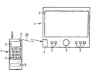
Bei dem ersten Ausführungsbeispiel gemäß Figur 1 wird von einer
fahrzeuggebundenen Navigationseinrichtung 1, welche das
übliche Display 2 sowie diverse Bedienelemente aufweist, ein
kompletter Datensatz mit den Positionsdaten PD des Fahrzeugabstellorts
und des Zielorts, den Umgebungsinformationen UI
um den Fahrzeugabstellort, den Zielort und einen dazwischenliegenden
Weg sowie die Wegdaten WD über den von der Navigationseinrichtung
ermittelten optimalen Weg an das portable,
fahrzeugunabhängige Navigationshilfegerät 5 übertragen.In the first exemplary embodiment according to FIG
vehicle-mounted
Das heißt, es wird hier zur Wahl des optimalen Wegs der sogenannte "Routefinder" in der Navigationseinrichtung des Fahrzeugs genutzt. Es wird so folglich eine komplette Karte übermittelt, in welcher der Fahrzeugabstellort, der Zielort und der optimale Weg eingezeichnet sind.This means that the so-called path is used to choose the optimal route "Route finder" in the navigation system of the vehicle used. So a complete map is transmitted, in which the vehicle parking location, the destination and the optimal route is drawn.
Das Navigationshilfegerät 5 zeigt diese Karte dann auf einem
Display 6 für den Benutzer an und gibt ggf. zusätzliche Sprachinformationen
über einen Lautsprecher 7 aus, sodass der Benutzer
auch akustisch entlang des Weges geleitet werden kann.The navigation aid 5 then shows this map on one
Bei dem hier nur schematisch dargestellten Navigationshilfegerät
5 kann es sich beispielsweise um ein Mobilfunkgerät
oder einen PDA handeln. Derartige Geräte weisen in der
Regel ohnehin ein Display und einen Lautsprecher für eine geeignete
Ausgabe der Informationen auf. Außerdem besitzen solche
Geräte auch in der Regel bereits eine geeignete Schnittstelle
zur Kommunikation mit anderen Geräten. Im vorliegenden
Fall handelt es sich um ein Bluetooth-Modul 8. Dementsprechend
ist auch die Navigationseinrichtung 1 im Fahrzeug mit
einem Bluetooth-Modul 3 ausgestattet, sodass über diesen
kurzreichweitigen Funkstandard die benötigten Daten übermittelt
werden.In the navigation aid device shown here only schematically
5 can be, for example, a mobile radio device
or trade a PDA. Such devices have in the
Usually a display and a speaker for a suitable one anyway
Output of the information on. They also have
Devices usually already have a suitable interface
for communication with other devices. In the present
Case is a
Eine zweite Alternative ist in Figur 2 dargestellt. Im Gegensatz
zu dem Ausführungsbeispiel gemäß Figur 1 werden hier nur
die Positionsdaten PD von der fahrzeuggebundenen Navigationseinrichtung
1 an das portable, fahrzeugunabhängige Navigationshilfegerät
5 übermittelt. Auch hier erfolgt die Übermittlung
über die Bluetooth-Module 3, 8. In einem Speicher 9 im
Navigationshilfegerät 5 sind jedoch bereits verschiedene
"Kartenausschnitte" oder eine Gesamtkarte für bestimmte Gebiete,
beispielsweise Deutschland oder Europa, und/oder z. B.
verschiedene Stadtpläne gespeichert. Anhand der übermittelten
Positionsdaten PD des Fahrzeugabstellorts und des Zielorts
wird dann die geeignete Karte herausgesucht bzw. ein geeigneter
Kartenausschnitt gewählt. Außerdem befindet sich bei diesem
Ausführungsbeispiel auch der "Routefinder" im Navigationshilfegerät
5. Das heißt, das Navigationshilfegerät 5 sucht
selbst den optimalen Weg zwischen dem Fahrzeugabstellort und
dem Zielort. Der "Routefinder" ist hier als ein Routefinder-Modul
10 dargestellt. Auch bei diesem Ausführungsbeispiel
kann es sich bei dem Navigationshilfegerät 5 um ein Mobilfunkgerät
oder ein PDA handeln, da diese Geräte ohnehin Speicherplatz
aufweisen und entsprechende Routefinder-Module sich
ebenfalls leicht als Software implementieren lassen.A second alternative is shown in Figure 2. In contrast
to the embodiment of Figure 1 are only here
the position data PD from the vehicle-mounted
Anstelle der Übertragung mittels Bluetooth ist es bei den genannten Ausführungsbeispielen alternativ auch möglich, eine andere Übertragungstechnik, beispielsweise mittels Infrarotoder Ultraschallmodulen, zu verwenden.Instead of transmission via Bluetooth, it is with the above Embodiments alternatively also possible other transmission technology, for example using infrared or Ultrasonic modules to use.
Ebenso ist eine direkte Steckverbindung als Schnittstelle einsetzbar. Bei Verwendung eines Mobilfunkgerätes als Navigationshilfegerät bietet es sich zudem an, die Schnittstelle einer Freisprecheinrichtung mitzuverwenden, sodass auf weitere zusätzliche Schnittstellen im Prinzip verzichtet werden kann.There is also a direct plug connection as an interface used. When using a mobile device as a navigation aid it also lends itself to the interface to use a hands-free system, so that more in principle, additional interfaces are dispensed with can.
Die Übertragung der Daten über diese Schnittstelle kann im
Übrigen - bei einer sehr komfortablen Ausführungsform -automatisch
bei Abstellen des Fahrzeuges, beispielsweise beim
Ausschalten der Zündung oder beim Abziehen des Zündschlüssels
geschehen. Das heißt, in einem solchen Fall wird beispielsweise
in die Navigationseinrichtung 1 des Fahrzeugs beim
Start nur der Zielort angegeben. Die Navigationseinrichtung
leitet den Fahrer dann zu einem nächstgelegenen Parkplatz
bzw. der Fahrer stellt selbsttätig sein Fahrzeug auf einem
geeigneten Parkplatz in der Nähe des angezeigten Zielorts ab.
Bei Ausschalten der Zündung wird dann der Restweg zwischen
dem automatisch ermittelten Fahrzeugstandort, welcher dem
Fahrzeugabstellort entspricht, und dem Zielort gemeinsam mit
dem passenden Kartenausschnitt an das Navigationshilfegerät 5
übermittelt und dort auf dem Display 6 für den Benutzer dargestellt.The data can be transferred via this interface in
Otherwise - in a very comfortable embodiment - automatically
when parking the vehicle, for example when
Switch off the ignition or remove the ignition key
happen. That is, in such a case, for example
in the
Bei dem dritten Ausführungsbeispiel gemäß Figur 3 weist die
Navigationseinrichtung 1 im Fahrzeug anstelle des Bluetooth-Moduls
3 eine Datenträgerschreibeinrichtung 4 auf. Mit dieser
Datenträgerschreibeinrichtung 4 werden die Positionsdaten auf
einem Datenträger 12, beispielsweise eine SIM-Card oder einen
CompactFlash- oder MultiMediaCard-Datenträger geschrieben.In the third exemplary embodiment according to
Im vorliegenden Ausführungsbeispiel handelt es sich hierbei um einen Datenträger 12, auf dem bereits die Daten für eine Karte des entsprechenden Bereichs enthalten sind. Das heißt, es existiert beispielsweise eine ganze Bibliothek von Datenträgern, wobei jeder Datenträger einen bestimmten Kartenbereich abdeckt. Beispielsweise enthält ein Datenträger einen Stadtplan vom Großraum München, ein weiterer Datenträger einen Stadtplan vom Großraum Hamburg, ein Datenträger eine Karte von Norddeutschland und ein Datenträger eine Karte von Süddeutschland usw. Der passende Datenträger wird jeweils von der Navigationseinrichtung angefordert und vom Benutzer eingelegt.This is the case in the present exemplary embodiment around a data carrier 12 on which the data for a Map of the corresponding area are included. This means, for example, there is an entire library of data carriers, where each disk has a specific map area covers. For example, a disk contains one City map of the greater Munich area, another data carrier one City map of the greater Hamburg area, a data carrier a map of northern Germany and a disk a map of Southern Germany etc. The appropriate data carrier is from the navigation device requested and inserted by the user.
Dieser Datenträger 12 wird dann von einem Navigationshilfegerät 5 mit einer geeigneten Datenträgerleseeinrichtung 11 ausgelesen, wobei im vorliegenden Ausführungsbeispiel vom Navigationshilfegerät 5 anhand der Positionsdaten sofort ein geeigneter Kartenausschnitt selektiert wird und dann nur die zu den Positionsdaten des Fahrzeugabstellorts und des Zielorts passende Umgebungsinformationen UI gelesen werden. Durch die Beschränkung auf die wirklich benötigten Daten kann die Lesegeschwindigkeit erhöht werden. In diesem Fall befindet sich ebenfalls im Navigationshilfegerät 5 ein Routefinder-Modul 10. Das heißt, auch bei diesem Ausführungsbeispiel wird anhand der Positionsdaten und der Umgebungsinformationen vom Navigationshilfegerät 5 selbst der optimale Weg gewählt.This data carrier 12 is then used by a navigation aid 5 with a suitable data carrier reading device 11 read out, in the present embodiment by the navigation aid 5 immediately based on the position data suitable map section is selected and then only the to the position data of the vehicle parking location and the destination suitable environment information can be read UI. By limiting it to the data that is really needed the reading speed can be increased. In this case there is also a route finder module in the navigation aid 5 10. That is, also in this embodiment is based on the position data and the environmental information chosen the optimal route by the navigation aid 5 itself.
Bei den Positionsdaten kann es sich im Prinzip um Adressen, mit Postleitzahl, Ort, Straße und Hausnummer handeln. Es kann sich jedoch auch um Koordinaten eines normierten Koordinatensystems handeln, mit dem sowohl das Navigationssystem als auch das Navigationshilfegerät 5 arbeitet. Vorzugsweise handelt es sich unabhängig von den genauen Daten jedoch um systemübergreifende Datenformate, sodass eine möglichst große Kompatibilität gewährleistet ist. Bei der Übergabe von Adressen kann beispielsweise das vCard- oder das iCard-Format verwendet werden.The position data can in principle be addresses, deal with postcode, town, street and house number. It can but also about coordinates of a standardized coordinate system act with both the navigation system as the navigation aid 5 also works. Preferably acts regardless of the exact data, however, it is cross-system Data formats so that the largest possible Compatibility is guaranteed. When passing addresses can use the vCard or iCard format, for example become.
Claims (12)
- A navigation method in which a vehicle is guided to a vehicle parking location at a distance from a destination by means of a navigation system having an on-board navigation device (1), characterized in that at least position data (PD) of the vehicle parking location and of the destination is transmitted by the navigation system to a vehicle-independent, portable auxiliary navigation unit (5) which determines a route between the vehicle parking location and the destination and outputs to a user information relating to said route by means of an output device (6, 7).
- The navigation method as claimed in claim 1, characterized in that vicinity information (UI) for the area surrounding the vehicle parking location, the destination and a route between the two is transmitted by the navigation system to the auxiliary navigation unit (5).
- The navigation method as claimed in claim 1, characterized in that vicinity information for the surroundings of various locations is already stored in a memory (9) in the auxiliary navigation unit (5), and on the basis of the position data (PD) of the vehicle parking location and of the destination obtained from the navigation system, the auxiliary navigation unit (5) selects a vicinity around the vehicle parking location, around the destination and a route between the two.
- The navigation method as claimed in one of claims 1 to 3, characterized in that the position data (PD) and/or vicinity information (UI) is transmitted by the on-board navigation device (1) via an interface (3, 8) to the auxiliary navigation unit (5).
- The navigation method as claimed in claim 4, characterized in that the interface (3, 8) is a wireless interface (3, 8).
- The navigation method as claimed in one of claims 1 to 3, characterized in that the position data and/or the vicinity information and/or the route data is written by the on-board navigation device onto a data carrier and is read by the auxiliary navigation unit from the data carrier.
- The navigation method as claimed in claim 6, characterized in that the position data (PD) is written by the on-board navigation device (1) onto a data carrier (12) on which vicinity information (UI) within a given range of the vehicle parking location is stored, and the position data (PD) and vicinity information (UI) are read from the data carrier (12) by the auxiliary navigation unit (5).
- The navigation method as claimed in one of claims 1 to 3, characterized in that the position data and/or vicinity information is transmitted by a data communication device of the navigation system to the auxiliary navigation unit.
- A navigation device (1) for a vehicle for carrying out a method as claimed in one of claims 1 to 8, having means for determining the position data (PD) of a selected vehicle parking location and of a selected destination and/or associated vicinity information (UI) for said locations and of a route between said locations, and having an interface (3) for the transmission of the position data (PD) and/or the vicinity information (UI) to a portable auxiliary navigation unit (5) and/or a data carrier writing device (4) for storing the position data (PD) and/or the vicinity information (UI) on a data carrier (12), wherein the auxiliary navigation unit (5) comprises means for determining the route between the vehicle parking location and the destination.
- A portable auxiliary navigation unit (5) for carrying out a method as claimed in one of claims 1 to 8, having means for determining the route between the vehicle parking location and the destination, having an interface (8) and/or a data carrier reading device (11) and having an output unit (6, 7), and having means for receiving data relating to a vehicle parking location and a destination from a navigation system via the interface (8) and/or for acquiring such data from a data carrier (12) and for outputting information to a user about a route between the vehicle parking location and the destination by means of the output unit (6, 7).
- An auxiliary navigation unit as claimed in claim 10, characterized in that the display unit (6, 7) comprises a display device (6), and the auxiliary navigation unit (5) has means for representing a map on the output unit (6) on the basis of the position data (PD) and the vicinity information (UI).
- An auxiliary navigation unit as claimed in claim 10 or 11, characterized in that the auxiliary navigation unit comprises a mobile communication device and/or PDA.
Applications Claiming Priority (3)
| Application Number | Priority Date | Filing Date | Title |
|---|---|---|---|
| DE10024475 | 2000-05-18 | ||
| DE10024475 | 2000-05-18 | ||
| PCT/DE2001/001783 WO2001088877A1 (en) | 2000-05-18 | 2001-05-10 | Navigation method |
Publications (2)
| Publication Number | Publication Date |
|---|---|
| EP1287513A1 EP1287513A1 (en) | 2003-03-05 |
| EP1287513B1 true EP1287513B1 (en) | 2004-09-29 |
Family
ID=7642599
Family Applications (1)
| Application Number | Title | Priority Date | Filing Date |
|---|---|---|---|
| EP01940227A Expired - Lifetime EP1287513B1 (en) | 2000-05-18 | 2001-05-10 | Navigation method |
Country Status (3)
| Country | Link |
|---|---|
| EP (1) | EP1287513B1 (en) |
| DE (1) | DE50103892D1 (en) |
| WO (1) | WO2001088877A1 (en) |
Cited By (1)
| Publication number | Priority date | Publication date | Assignee | Title |
|---|---|---|---|---|
| DE102006054346A1 (en) * | 2006-11-17 | 2008-05-21 | Conti Temic Microelectronic Gmbh | Satellite-based navigation device for determining geographical position of vehicle in e.g. forest area, has interface e.g. infra-red interface, for receiving movement data of vehicle, where navigation device is mobile device |
Families Citing this family (9)
| Publication number | Priority date | Publication date | Assignee | Title |
|---|---|---|---|---|
| WO2004094953A1 (en) * | 2003-04-17 | 2004-11-04 | Atx Europe Gmbh | Driving route planning method |
| DE10327952A1 (en) * | 2003-06-20 | 2005-01-05 | Harman Becker Automotive Systems Gmbh | navigation system |
| US20050060118A1 (en) * | 2003-09-11 | 2005-03-17 | Nokia Corporation | Terminal and an associated system, method and computer program product for obtaining the terminal location based upon connections of the terminal |
| DE102007046317A1 (en) * | 2007-09-27 | 2009-04-02 | Robert Bosch Gmbh | navigation system |
| DE102008032637A1 (en) * | 2008-07-11 | 2010-01-21 | Navigon Ag | Method for operating a navigation device |
| JP2010060400A (en) * | 2008-09-03 | 2010-03-18 | Sony Corp | Navigator, navigator display method, program of navigator display method, and recording medium for program of navigator display method |
| US8914229B2 (en) * | 2013-03-15 | 2014-12-16 | Google Inc. | Systems and methods for transferring navigation data |
| DE102014013207A1 (en) * | 2014-09-06 | 2015-08-27 | Audi Ag | A method for navigating a user between a first position within a building area and a second location |
| CN104880195A (en) * | 2015-06-02 | 2015-09-02 | 瑞声声学科技(深圳)有限公司 | Mobile communications and navigation terminal and navigation method thereof |
Family Cites Families (6)
| Publication number | Priority date | Publication date | Assignee | Title |
|---|---|---|---|---|
| DE19521929A1 (en) * | 1994-10-07 | 1996-04-11 | Mannesmann Ag | Facility for guiding people |
| JP3893647B2 (en) * | 1996-09-30 | 2007-03-14 | マツダ株式会社 | Navigation device |
| JPH10103990A (en) * | 1996-09-30 | 1998-04-24 | Mazda Motor Corp | Mobile communication system |
| EP1060463B1 (en) * | 1998-05-22 | 2005-01-26 | Hans-Detlef Brust | Device and method for locating a parked vehicle |
| DE19828077A1 (en) * | 1998-06-24 | 1999-12-30 | Bosch Gmbh Robert | Navigation system for transport arrangement, esp. for motor vehicle or ship |
| DE19848192A1 (en) * | 1998-10-20 | 2000-04-27 | Volkswagen Ag | Vehicle navigation device has computer and navigation unit installed as a device unit in vehicle which is capable of correspondence with portable screen attached to GPS receiver and GSM interface of further vehicle |
-
2001
- 2001-05-10 EP EP01940227A patent/EP1287513B1/en not_active Expired - Lifetime
- 2001-05-10 DE DE50103892T patent/DE50103892D1/en not_active Expired - Lifetime
- 2001-05-10 WO PCT/DE2001/001783 patent/WO2001088877A1/en active IP Right Grant
Cited By (1)
| Publication number | Priority date | Publication date | Assignee | Title |
|---|---|---|---|---|
| DE102006054346A1 (en) * | 2006-11-17 | 2008-05-21 | Conti Temic Microelectronic Gmbh | Satellite-based navigation device for determining geographical position of vehicle in e.g. forest area, has interface e.g. infra-red interface, for receiving movement data of vehicle, where navigation device is mobile device |
Also Published As
| Publication number | Publication date |
|---|---|
| DE50103892D1 (en) | 2004-11-04 |
| WO2001088877A1 (en) | 2001-11-22 |
| EP1287513A1 (en) | 2003-03-05 |
Similar Documents
| Publication | Publication Date | Title |
|---|---|---|
| DE602004003789T2 (en) | Method for entering destination information via a mobile terminal | |
| DE60212278T2 (en) | System and method for integrating subscriber-based navigation data and accommodation data with GPS data | |
| EP0697580B1 (en) | Navigation system for a vehicle | |
| DE69531248T2 (en) | INTELLIGENT GUIDE SYSTEM FOR VEHICLES | |
| DE69726662T2 (en) | Land vehicle navigation device with local route selectivity and storage medium therefor | |
| DE60010080T2 (en) | PORTABLE INFORMATION DEVICE FOR DRIVERS | |
| EP0805952B1 (en) | Navigation device for people | |
| EP1198696B1 (en) | Method and device for transmitting navigational information from a central data unit to a navigation system, located in a motor-vehicle | |
| DE112005000605T5 (en) | Navigation device displaying dynamic travel information | |
| DE19808802A1 (en) | Motor vehicle navigation system | |
| WO2000034933A1 (en) | Device and method for locating a parked vehicle | |
| EP1800274B1 (en) | Portable computer for navigation tasks | |
| DE112009004311T5 (en) | Method and apparatus for providing a navigation summary | |
| EP1287513B1 (en) | Navigation method | |
| EP1133675B1 (en) | Navigation device and navigation method | |
| DE60316536T2 (en) | Database system for a navigation device | |
| DE19521917C2 (en) | Method and device for determining the position of a vehicle | |
| WO2002037446A1 (en) | Navigation method and a device for carrying out the same | |
| EP1038282A2 (en) | Navigation system for a locomotive means | |
| DE102010056404A1 (en) | Downloaded destinations and interface for multiple in-vehicle navigation devices | |
| WO2005083362A1 (en) | Navigation system | |
| DE102005061698B4 (en) | Method for automatic entry in an address book | |
| WO2007025717A1 (en) | Communications system for data transmission between a motor vehicle and an mobile radio set located outside thereof | |
| EP1376991B1 (en) | Apparatus for transmitting data between a vehicle and a mobile terminal | |
| DE19947790A1 (en) | Navigation system with automatic data medium change |
Legal Events
| Date | Code | Title | Description |
|---|---|---|---|
| PUAI | Public reference made under article 153(3) epc to a published international application that has entered the european phase |
Free format text: ORIGINAL CODE: 0009012 |
|
| 17P | Request for examination filed |
Effective date: 20021105 |
|
| AK | Designated contracting states |
Kind code of ref document: A1 Designated state(s): AT BE CH CY DE DK ES FI FR GB GR IE IT LI LU MC NL PT SE TR |
|
| RIN1 | Information on inventor provided before grant (corrected) |
Inventor name: ZECHLIN, OLIVER |
|
| 17Q | First examination report despatched |
Effective date: 20030507 |
|
| GRAP | Despatch of communication of intention to grant a patent |
Free format text: ORIGINAL CODE: EPIDOSNIGR1 |
|
| GRAS | Grant fee paid |
Free format text: ORIGINAL CODE: EPIDOSNIGR3 |
|
| GRAA | (expected) grant |
Free format text: ORIGINAL CODE: 0009210 |
|
| AK | Designated contracting states |
Kind code of ref document: B1 Designated state(s): DE FR GB |
|
| REG | Reference to a national code |
Ref country code: GB Ref legal event code: FG4D Free format text: NOT ENGLISH |
|
| GBT | Gb: translation of ep patent filed (gb section 77(6)(a)/1977) | ||
| REG | Reference to a national code |
Ref country code: IE Ref legal event code: FG4D Free format text: GERMAN |
|
| REF | Corresponds to: |
Ref document number: 50103892 Country of ref document: DE Date of ref document: 20041104 Kind code of ref document: P |
|
| REG | Reference to a national code |
Ref country code: IE Ref legal event code: FD4D |
|
| ET | Fr: translation filed | ||
| PLBE | No opposition filed within time limit |
Free format text: ORIGINAL CODE: 0009261 |
|
| STAA | Information on the status of an ep patent application or granted ep patent |
Free format text: STATUS: NO OPPOSITION FILED WITHIN TIME LIMIT |
|
| 26N | No opposition filed |
Effective date: 20050630 |
|
| REG | Reference to a national code |
Ref country code: FR Ref legal event code: PLFP Year of fee payment: 16 |
|
| REG | Reference to a national code |
Ref country code: FR Ref legal event code: PLFP Year of fee payment: 17 |
|
| REG | Reference to a national code |
Ref country code: FR Ref legal event code: PLFP Year of fee payment: 18 |
|
| PGFP | Annual fee paid to national office [announced via postgrant information from national office to epo] |
Ref country code: FR Payment date: 20180516 Year of fee payment: 18 |
|
| PGFP | Annual fee paid to national office [announced via postgrant information from national office to epo] |
Ref country code: DE Payment date: 20180719 Year of fee payment: 18 Ref country code: GB Payment date: 20180516 Year of fee payment: 18 |
|
| REG | Reference to a national code |
Ref country code: DE Ref legal event code: R119 Ref document number: 50103892 Country of ref document: DE |
|
| GBPC | Gb: european patent ceased through non-payment of renewal fee |
Effective date: 20190510 |
|
| PG25 | Lapsed in a contracting state [announced via postgrant information from national office to epo] |
Ref country code: DE Free format text: LAPSE BECAUSE OF NON-PAYMENT OF DUE FEES Effective date: 20191203 Ref country code: GB Free format text: LAPSE BECAUSE OF NON-PAYMENT OF DUE FEES Effective date: 20190510 |
|
| PG25 | Lapsed in a contracting state [announced via postgrant information from national office to epo] |
Ref country code: FR Free format text: LAPSE BECAUSE OF NON-PAYMENT OF DUE FEES Effective date: 20190531 |