EP0505152B1 - Kartenanzeigegerät - Google Patents
Kartenanzeigegerät Download PDFInfo
- Publication number
- EP0505152B1 EP0505152B1 EP92302302A EP92302302A EP0505152B1 EP 0505152 B1 EP0505152 B1 EP 0505152B1 EP 92302302 A EP92302302 A EP 92302302A EP 92302302 A EP92302302 A EP 92302302A EP 0505152 B1 EP0505152 B1 EP 0505152B1
- Authority
- EP
- European Patent Office
- Prior art keywords
- map
- name
- data
- display
- start point
- Prior art date
- Legal status (The legal status is an assumption and is not a legal conclusion. Google has not performed a legal analysis and makes no representation as to the accuracy of the status listed.)
- Expired - Lifetime
Links
- 238000000034 method Methods 0.000 description 6
- 230000004044 response Effects 0.000 description 3
- 238000010586 diagram Methods 0.000 description 2
- 230000005389 magnetism Effects 0.000 description 2
- 238000006243 chemical reaction Methods 0.000 description 1
- 238000001514 detection method Methods 0.000 description 1
- 230000000694 effects Effects 0.000 description 1
- 239000004973 liquid crystal related substance Substances 0.000 description 1
- 238000012544 monitoring process Methods 0.000 description 1
Images


Classifications
-
- G—PHYSICS
- G01—MEASURING; TESTING
- G01C—MEASURING DISTANCES, LEVELS OR BEARINGS; SURVEYING; NAVIGATION; GYROSCOPIC INSTRUMENTS; PHOTOGRAMMETRY OR VIDEOGRAMMETRY
- G01C21/00—Navigation; Navigational instruments not provided for in groups G01C1/00 - G01C19/00
- G01C21/26—Navigation; Navigational instruments not provided for in groups G01C1/00 - G01C19/00 specially adapted for navigation in a road network
- G01C21/34—Route searching; Route guidance
- G01C21/36—Input/output arrangements for on-board computers
- G01C21/3667—Display of a road map
- G01C21/3673—Labelling using text of road map data items, e.g. road names, POI names
Definitions
- the present invention relates to an on-board navigation apparatus and more particularly, an on-board navigation apparatus designed to display, at a display device (referred to as a display hereinafter), pictures including map information on the basis of the position of the vehicle itself.
- a display referred to as a display hereinafter
- On-board navigation apparatuses have been introduced for practical use, in which map information is previously stored in memory, and retrieved from memory for display into a display device together with a current position of the vehicle, so that the vehicle is navigated to a predetermined destination.
- Map information to be displayed is previously stored in a storage medium, e.g. a CD-ROM, and particular map information is read-out and loaded into a buffer memory prior to be transferred to the display device.
- Map data is retrieved from the CD-ROM according to the sort of data, and is formed by loading into the buffer memory so-called geographical data representing the shape of roads, rivers, mountains, buildings, and so on, and name data for indicating the name of corresponding items.
- the geographical data and name data are superimposed with each other so that the map data is drawn in the buffer memory.
- the name data may be included as a part of map data of a single sort prepared in the CD-ROM, so that the name data can by displayed by using such map data.
- Fig. 2 shows an example of display of roads as geographical data and corresponding names as name data on the display.
- the north direction of the map is normally displayed on the display. More particularly, the manner of display in this case is that the upward direction of the display screen d corresponds to the north direction on the map.
- Each road shown by a bold line is accompanied with its name, e.g. route 1 (when the road name is expressed in Japanese language, Kanji characters of, e.g. meaning "national highway route 1", may be used).
- These letters or characters representing the road name are arranged either downward from top to bottom in the case of vertical writing, or horizontally from left to right in the case of horizontal writing.
- EP-A-0059435 and EP-A-0355232 describe map display devices in which the geographical names are always displayed horizontally. The coordinate for an area name is stored and a screen coordinate-calculated display according to the display direction of the map. The name is then displayed horizontally about the calculated screen coordinate. While the names are always legible, they are sometimes not easily related to the point being named.
- WO-A-86/02764 describes a system in which street names are displayed, running parallel to the street. Two end points are provided, the displayed name running between the end points, in a direction from the left most point displayed. However, the characters are not oriented in a particular direction relative to the map display direction making reading difficult in many cases.
- the present invention has been made in view of the drawback described in the foregoing, and an object of the present invention is to provide an improved on-board navigation apparatus which constantly displays each name data in legible order and arrangement, when displaying map information, even if the display direction is changed to any of the north, south, east, and west, directions.
- the present invention provides a map display device as defined in claim 1.
- each name data is calculated by using coordinate data of the name data with reference to the display direction of the north, south, east and west directions as well as the number of characters, and the geographical data and the name data are superimposed by using the calculated drawing start point.
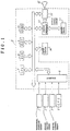
- Fig. 1 is a block diagram of an on-board navigation apparatus in which the display device according to the present invention is suitably adopted. The embodiment will be described specifically with reference to this drawing.
- a terrestrial magnetism sensor 1 for producing azimuth data of the vehicle by the detection of terrestrial magnetism (earth's magnetic field), an angular velocity sensor 2 for detecting an angular velocity of the vehicle, a running distance sensor 3 for measuring the distance traveled by the vehicle, a GPS (global positioning system) 4 for detecting the current position of the vehicle from latitude and longitude information and so on, and a system controller 5 to which outputs of the sensors (and system) 1 to 4 are supplied.
- terrestrial magnetism sensor 1 for producing azimuth data of the vehicle by the detection of terrestrial magnetism (earth's magnetic field)
- an angular velocity sensor 2 for detecting an angular velocity of the vehicle
- a running distance sensor 3 for measuring the distance traveled by the vehicle
- GPS (global positioning system) 4 for detecting the current position of the vehicle from latitude and longitude information and so on
- a system controller 5 to which outputs of the sensors (and system) 1 to 4 are supplied.
- the system controller 5 comprises an interface 6 for receiving the outputs of the sensors (and system) 1 to 4 and performing, for example, an A/D conversion of the received signals, a CPU (central processing unit) 7 for performing various image processing operations and calculating e.g. the amount of movement of the vehicle from the output data of the sensors 1 to 4 successively supplied through the interface 6, a ROM (read only memory) 8 for storage of various processing programs for the CPU 7 and of other necessary data, a RAM (random access memory) 9 into and from which information needed for the execution of program is written and read out, a recording medium 10, e.g.
- a CD-ROM or an IC card which carries digitized map data
- a buffer memory 11 for temporary storing image data ready for the display, operating as a frame buffer and comprising e.g. a video RAM
- a graphic controller 13 for writing the data, e.g. geographical information, supplied in response to command of the CPU 7, into the buffer memory 11 and outputting the data as image information
- a display controlling circuit 15 for controlling a display 12, e.g. a liquid crystal display device or a CRT, in response to the image data supplied from the graphic controller 13.
- an input device 14, e.g. a keyboard is provided for transmitting a variety of commands to the system controller 5 in response to key entry by an operator.
- the geographical data and associated name data together forming map data are respectively stored in the CD-ROM 10 or the buffer memory 11.
- Each data is in the form of pixel data prepared for absolute coordinates (X, Y) on the map of, for example, longitude and latitude information.
- absolute coordinates are formed with the south to north direction of the map orientaion being registered on a positive direction of the X-axis and the east to west direction being registered on a positive direction of the Y-axis.
- Each name data is formed by a groups of pixel data, each group forming a character, for example, in a square area of 16 ⁇ 16 dots. More specifically, the name data is retrieved from the ROM 8 for each character of the name data by using a so-called character code group, such as Kanji code group, each code of which designates a particular pattern of the pixel data.
- each name data has a pair of absolute coordinate data for a reference pixel data (point P) at the head of a data string of the first character of the name data.
- the point P will be referred to as name reference point hereinafter.
- each name data contains absolute coordinate data assigned at its name reference point.
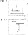
- the name data includes data representing a drawing area particular to each name data on the basis of the name reference point. The area will be designated as name area which is defined, for example, as an interior of the rectangle surrounding the characters of "ROUTE1" in Fig. 5.
- the coordinate data of a drawing start point Q for the characters of a name is calculated from the absolute coordinates of the name reference point P according to the display direction of the map.
- the drawing start point Q is then used as a new reference point for arranging the name data relative to the geographical data.
- This procedure is provided as a subroutine of a main routine performing a variety of procedure such as the calculation of current position of the vehicle, retrieval of map data, etc. Since this main routine is similar to the one disclosed in Japanese Patent Application Laid-Open No. 63-12096, the detailed explanation thereof will not be made.
- the procedure starts with the operation of the CPU 7 to retrieve the name reference point P and the name area of the name data to be displayed and the display direction of the map image (Step S1).
- Step S2, S3, and S4 It is then determined how the name data is to be superimposed on the geographical data drawn in the buffer memory 11 according to the retrieved display direction of the map orientation.
- name data is drawn into the buffer memory 11 at step S9 so that the name data is received within the name area. If the geographical data has already been drawn in the buffer memory 11 at this point of time, the name data is drawn to be superimposed on the geographical data, to compose the map data.
- Step S5 the drawing start point Q of the name data is identical to the name reference point P as the upward direction of the display image is set to the north direction.
- the map data obtained by the superimposition is legibly displayed as shown in Fig. 5 if display control is performed so that the positive direction of the absolute coordinate axis X is directed upward in the display image.
- the drawing start point Q of the name data is displaced from the name reference point P by an amount corresponding to the number of characters composing the name in the negative direction of the absolute coordinate axis Y as the upward direction of the display image is set to the east direction. Accordingly, the map data obtained by the superimposition is legibly displayed as shown in Fig. 6 if the display control is performed so that the negative direction of the absolute coordinate axis Y is directed upward in the display image.
- the drawing start point Q of the name data is displaced from the name reference point P by an amount corresponding to the width of one character in the negative direction of the absolute coordinate axis X and an amount corresponding to the number of characters composing the name in the negative direction of the absolute coordinate axis Y as the south direction is set to the upward direction of the display image. Accordingly, the map data obtained by the superimposition is legibly displayed as shown in Fig. 7 if the display control is performed so that the negative direction of the absolute coordinate axis X is set to the upward direction of the display image.
- Step S8 the drawing start point Q of the name data is displaced from the name reference point P by the amount corresponding to the width of one character in the negative direction of the absolute coordinate axis X as the west direction is set to the upward direction of the display image. Accordingly, the map data obtained by the superimposition is legibly displayed as shown in Fig. 8 if the display control is performed so that the positive direction of the absolute coordinate axis Y is directed to the upward direction of the display image.
- the positional relation between the drawing start point Q and the name reference point P is varied according the change in the display direction of the map orientation, so that the name data always is displayed in a fixed order and direction.
- the foregoing description is made for the case where characters composing the name data are aligned along the absolute coordinate axis Y as shown in Fig. 5.
- the name data is displayed in legible order and direction to the user as shown in Fig. 9.
- the present invention allows the calculation of coordinates of a drawing start point from absolute coordinates of the name reference point in the name data according to the display direction of the map orientation, and the superimposition of the name data on the geographical data on the basis of the drawing start point.
- the name data can be displayed in legible order and direction in the screen of a map display device regardless of changes in the display direction of the map orientation, that is, the north, south, east and west direction. This permits a driver of the vehicle to read the name data on the map display with much ease and thus, the display device of the invention is advantageous for use with a car navigation apparatus in which a number of name data is superimposed on geographical data.
Landscapes
- Engineering & Computer Science (AREA)
- Radar, Positioning & Navigation (AREA)
- Remote Sensing (AREA)
- Automation & Control Theory (AREA)
- Physics & Mathematics (AREA)
- General Physics & Mathematics (AREA)
- Navigation (AREA)
- Traffic Control Systems (AREA)
- Instructional Devices (AREA)
Claims (1)
- Kärtenwiedergäbegerät, aufweisend:ein Speicherungsmedium (10) zum Speichern von geographischen Daten, um Elemente, wie zum Beispiel Straßen darzustellen, und von Namensdaten, um den Namen der von den geographischen Daten darzustellenden Elemente wiederzugeben; wobei die Namensdaten eine Namenszone aufweisen, die eine rechteckige Zone repräsentiert. und Daten darstellende Zeichen aufweisen. die den Namen eines dargestellten, innerhalb der Namenszone anzuordnenden Elements, und einen durch absolute Koordinaten (Xp, Yp) in der Karte definierten Bezugspunkt (P) bezeichnen, wobei die absoluten Koordinaten (Xp, Yp) die Position einer Ecke der Namenszone definieren, und die Namenszone relativ zu den geographischen Daten fest ist;Lesemittel (7) zum Lesen der geographischen Daten und der Namensdaten eines vorgegebenen regionalen Teils in dem Speicherungsmedium (10);Wiedergewinnungsmittel (7) zum Wiedergewinnen einer Wiedergaberichtung, in der die Karte zu orientieren ist, wenn sie wiedergegeben wird, wobei diese Wiedergaberichtung eine der vier möglichen orthogonalen Richtungen ist;Berechnungsmittel zum Berechnen von Kartenkoordinaten (XQ, YQ) eines Schriftanfangspunktes (Q) in der Karte entsprechend der Wiedergaberichtung der Kartenorientierung und den absoluten Koordinaten (Xp, Yp), wobei der Schriftanfangspunkt die obere linke Ecke der Namenszone repräsentiert, wenn die Karte wiedergegeben wird, und wobei die Berechnungsmittel jede der absoluten Koordinaten (Xp, Yp) als die Koordinaten (XQ,YQ) des Schriftanfangspunktes (Q) aufrechterhalten, wenn die Karte in der ersten Orientierung wiedergegeben wird, und, wenn die Karte in einer der anderen Orientierungenwiedergegebenwird, die Schriftanfangspunkt-Kartenkoordinaten (XQ, YQ) berechnen durch Änderung der absoluten Koordinaten (Xp, Yp) um die Länge und/oder Breite der Namenszone, so daß der Schriftanfangspunkt (Q) in der oberen linken Ecke der Namenszone gelegen ist, wenn die Karte in einer anderen Orientierung wiedergegeben wird, wobei der Bezugspunkt (Xp, Yp) bei der anderen Orientierung in einer der anderen Ecken der Namenszone gelegen ist;Überlagerungsmittel (7, 11, 13) zum Kombinieren der geographischen Daten mit den Namensdaten, einschließlich der berechneten Kartenkoordinaten (XQ, YQ) des Schriftanfangspunktes (Q) der Namensdaten, und zum Orientieren der von den Namensdaten in der Namenszone gebildeten Zeichen entsprechend der Wiedergaberichtung, um die Zeichen der Namenszone in lesbarer Reihenfolge und Anordnung ab dem Schriftanfangspunkt wiederzugeben, und die Kartendaten zu bilden; undWiedergabesteuermittel (15) zum Steuern der Wiedergabe der Kartendaten, um eine Karte wiederzugeben.
Applications Claiming Priority (2)
| Application Number | Priority Date | Filing Date | Title |
|---|---|---|---|
| JP52542/91 | 1991-03-18 | ||
| JP3052542A JPH04288584A (ja) | 1991-03-18 | 1991-03-18 | 地図表示装置 |
Publications (3)
| Publication Number | Publication Date |
|---|---|
| EP0505152A2 EP0505152A2 (de) | 1992-09-23 |
| EP0505152A3 EP0505152A3 (en) | 1993-02-10 |
| EP0505152B1 true EP0505152B1 (de) | 1996-11-06 |
Family
ID=12917670
Family Applications (1)
| Application Number | Title | Priority Date | Filing Date |
|---|---|---|---|
| EP92302302A Expired - Lifetime EP0505152B1 (de) | 1991-03-18 | 1992-03-18 | Kartenanzeigegerät |
Country Status (4)
| Country | Link |
|---|---|
| US (1) | US5297051A (de) |
| EP (1) | EP0505152B1 (de) |
| JP (1) | JPH04288584A (de) |
| DE (1) | DE69214986T2 (de) |
Families Citing this family (59)
| Publication number | Priority date | Publication date | Assignee | Title |
|---|---|---|---|---|
| FR2683355A1 (fr) * | 1991-10-30 | 1993-05-07 | Bertrand Georges | Lecteur de cartes numerisees portable. |
| AU6909494A (en) * | 1993-05-13 | 1994-12-12 | Tour Information Systems, Inc. | Location-triggered interactive data retrieval system |
| JP3227272B2 (ja) * | 1993-05-28 | 2001-11-12 | アイシン・エィ・ダブリュ株式会社 | ナビゲーション装置 |
| JP2868393B2 (ja) * | 1993-07-27 | 1999-03-10 | アイシン・エィ・ダブリュ株式会社 | ナビゲーション装置 |
| EP0652418B1 (de) * | 1993-11-05 | 1998-02-04 | Koninklijke Philips Electronics N.V. | Fahrzeugnavigationsanzeigesystem |
| AU1062695A (en) * | 1993-11-26 | 1995-06-13 | Mannesmann Aktiengesellschaft | Process for producing a digitised road map |
| US5528501A (en) * | 1994-03-28 | 1996-06-18 | At&T Corp. | System and method for supplying travel directions |
| JP3555191B2 (ja) * | 1994-09-02 | 2004-08-18 | 株式会社デンソー | 副経路設定装置およびナビゲーション装置 |
| US5672840A (en) * | 1994-12-21 | 1997-09-30 | Trw Inc. | Method and apparatus for automatically orienting a computer display |
| JP3568621B2 (ja) | 1995-04-20 | 2004-09-22 | 株式会社日立製作所 | 地図表示装置 |
| KR0183524B1 (ko) * | 1995-09-27 | 1999-04-15 | 모리 하루오 | 네비게이션 장치 |
| US5910882A (en) | 1995-11-14 | 1999-06-08 | Garmin Corporation | Portable electronic device for use in combination portable and fixed mount applications |
| US5745866A (en) * | 1996-01-09 | 1998-04-28 | Trimble Navigation Limited | Cardinal-up graphic map display system |
| USD384661S (en) * | 1996-08-28 | 1997-10-07 | Garmin Corporation | Portable handheld combination GPS and communication transceiver |
| US6459987B1 (en) | 1996-11-15 | 2002-10-01 | Garmin Corporation | Method and apparatus for backtracking a path |
| US5936553A (en) * | 1997-02-28 | 1999-08-10 | Garmin Corporation | Navigation device and method for displaying navigation information in a visual perspective view |
| US5973734A (en) | 1997-07-09 | 1999-10-26 | Flashpoint Technology, Inc. | Method and apparatus for correcting aspect ratio in a camera graphical user interface |
| US5995970A (en) * | 1997-08-01 | 1999-11-30 | Garmin Corporation | Method and apparatus for geographic coordinate data storage |
| US6252605B1 (en) | 1997-08-01 | 2001-06-26 | Garmin Corporation | System and method for packing spatial data in an R-tree |
| US6092076A (en) * | 1998-03-24 | 2000-07-18 | Navigation Technologies Corporation | Method and system for map display in a navigation application |
| US6163749A (en) * | 1998-06-05 | 2000-12-19 | Navigation Technologies Corp. | Method and system for scrolling a map display in a navigation application |
| US6088649A (en) * | 1998-08-05 | 2000-07-11 | Visteon Technologies, Llc | Methods and apparatus for selecting a destination in a vehicle navigation system |
| US6076039A (en) * | 1998-09-03 | 2000-06-13 | Garmin Corporation | Navigation device and method for displaying cartographic markers |
| US6215671B1 (en) | 1998-12-10 | 2001-04-10 | Garmin Corporation | Method and apparatus for connecting circuit boards |
| US6250553B1 (en) | 1998-12-30 | 2001-06-26 | Garmin Corporation | Data card having a retractable handle |
| US6317141B1 (en) | 1998-12-31 | 2001-11-13 | Flashpoint Technology, Inc. | Method and apparatus for editing heterogeneous media objects in a digital imaging device |
| US6565610B1 (en) | 1999-02-11 | 2003-05-20 | Navigation Technologies Corporation | Method and system for text placement when forming maps |
| JP2001124579A (ja) * | 1999-10-27 | 2001-05-11 | Nippon Seiki Co Ltd | ナビゲーション装置 |
| FR2801158B1 (fr) * | 1999-11-17 | 2002-03-08 | Sagem | Appareil portable comportant des moyens d'orientation procede d'utilisation d'un tel appareil et procede d'orientation correspondant |
| US6735516B1 (en) | 2000-09-06 | 2004-05-11 | Horizon Navigation, Inc. | Methods and apparatus for telephoning a destination in vehicle navigation |
| US6536123B2 (en) | 2000-10-16 | 2003-03-25 | Sensation, Inc. | Three-axis magnetic sensor, an omnidirectional magnetic sensor and an azimuth measuring method using the same |
| US6704645B1 (en) * | 2001-12-11 | 2004-03-09 | Garmin Ltd. | System and method for estimating impedance time through a road network |
| US7283905B1 (en) | 2001-12-11 | 2007-10-16 | Garmin Ltd. | System and method for estimating impedance time through a road network |
| US6647337B1 (en) | 2001-12-20 | 2003-11-11 | Garmin Ltd. | Navigation system, method and device for labeling thoroughfares |
| US6847884B1 (en) | 2001-12-20 | 2005-01-25 | Garmin Ltd. | PDA system, method and device for labeling thoroughfares |
| US6545637B1 (en) | 2001-12-20 | 2003-04-08 | Garmin, Ltd. | Systems and methods for a navigational device with improved route calculation capabilities |
| US6999873B1 (en) | 2001-12-21 | 2006-02-14 | Garmin Ltd. | Navigation system, method and device with detour algorithm |
| US6847890B1 (en) | 2001-12-21 | 2005-01-25 | Garmin Ltd. | Guidance with feature accounting for insignificant roads |
| US7277794B1 (en) | 2001-12-21 | 2007-10-02 | Garmin Ltd. | Guidance with feature accounting for insignificant roads |
| US6892135B1 (en) | 2001-12-21 | 2005-05-10 | Garmin Ltd. | Navigation system, method and device with automatic next turn page |
| US7184886B1 (en) | 2001-12-21 | 2007-02-27 | Garmin Ltd. | Navigation system, method and device with detour algorithm |
| GB0208835D0 (en) * | 2002-04-18 | 2002-05-29 | Koninkl Philips Electronics Nv | A method of labelling an image on a display |
| US20060212185A1 (en) * | 2003-02-27 | 2006-09-21 | Philp Joseph W | Method and apparatus for automatic selection of train activity locations |
| JP4597496B2 (ja) * | 2003-09-04 | 2010-12-15 | 三菱電機株式会社 | 表示装置 |
| JP2005115174A (ja) * | 2003-10-09 | 2005-04-28 | Navitime Japan Co Ltd | 地図表示装置、地図表示方法および地図表示プログラム |
| US7908080B2 (en) | 2004-12-31 | 2011-03-15 | Google Inc. | Transportation routing |
| KR100688018B1 (ko) * | 2005-02-16 | 2007-02-27 | 엘지전자 주식회사 | 도로 명 데이터의 표시위치 결정방법 |
| US7796837B2 (en) * | 2005-09-22 | 2010-09-14 | Google Inc. | Processing an image map for display on computing device |
| US7925320B2 (en) * | 2006-03-06 | 2011-04-12 | Garmin Switzerland Gmbh | Electronic device mount |
| US9224145B1 (en) | 2006-08-30 | 2015-12-29 | Qurio Holdings, Inc. | Venue based digital rights using capture device with digital watermarking capability |
| JP4367538B2 (ja) * | 2007-07-17 | 2009-11-18 | 株式会社デンソー | 車両用ナビゲーション装置 |
| US20090244095A1 (en) * | 2008-04-01 | 2009-10-01 | Research In Motion Limited | Run-time label cache for efficient map labeling |
| CA2725582A1 (en) * | 2008-05-29 | 2009-12-03 | Tomtom International B.V. | Generating a map display image |
| JP2011134192A (ja) * | 2009-12-25 | 2011-07-07 | Casio Computer Co Ltd | 文字列表示装置、文字列表示方法およびプログラム |
| US9146133B2 (en) * | 2011-06-06 | 2015-09-29 | Honeywell International Inc. | Methods and systems for displaying procedure information on an aircraft display |
| US8237745B1 (en) | 2011-09-26 | 2012-08-07 | Google Inc. | Label positioning technique to reduce crawling during zoom activities |
| US9718558B2 (en) | 2014-02-26 | 2017-08-01 | Honeywell International Inc. | Pilot centered system and method for decluttering aircraft displays |
| CN107462253B (zh) * | 2016-06-06 | 2019-01-11 | 腾讯科技(深圳)有限公司 | 一种导航数据处理方法、装置及系统 |
| CN110347759A (zh) * | 2019-05-20 | 2019-10-18 | 菜鸟智能物流控股有限公司 | 地理区域管理方法和装置以及电子设备 |
Family Cites Families (7)
| Publication number | Priority date | Publication date | Assignee | Title |
|---|---|---|---|---|
| JPS57144589A (en) * | 1981-03-04 | 1982-09-07 | Nissan Motor | Picture display unit |
| JPS57169785A (en) * | 1981-04-13 | 1982-10-19 | Nissan Motor | Travelling guidance system for car |
| JPS5825686A (ja) * | 1981-08-07 | 1983-02-15 | アルプス電気株式会社 | 軌跡の表示位置移動機能をもつ車載用コ−ス誘導システム |
| AU5064485A (en) * | 1984-10-22 | 1986-05-15 | Etak Inc. | Apparatus and method for displaying a map |
| JPS61261772A (ja) * | 1985-05-16 | 1986-11-19 | 株式会社デンソー | 地図表示装置 |
| JPH07113999B2 (ja) * | 1986-07-02 | 1995-12-06 | パイオニア株式会社 | 車両の現在地認識方法 |
| JP2798934B2 (ja) * | 1988-08-23 | 1998-09-17 | アイシン・エィ・ダブリュ株式会社 | ナビゲーション装置 |
-
1991
- 1991-03-18 JP JP3052542A patent/JPH04288584A/ja active Pending
-
1992
- 1992-03-10 US US07/848,921 patent/US5297051A/en not_active Expired - Fee Related
- 1992-03-18 EP EP92302302A patent/EP0505152B1/de not_active Expired - Lifetime
- 1992-03-18 DE DE69214986T patent/DE69214986T2/de not_active Expired - Fee Related
Also Published As
| Publication number | Publication date |
|---|---|
| DE69214986T2 (de) | 1997-03-20 |
| JPH04288584A (ja) | 1992-10-13 |
| EP0505152A2 (de) | 1992-09-23 |
| DE69214986D1 (de) | 1996-12-12 |
| US5297051A (en) | 1994-03-22 |
| EP0505152A3 (en) | 1993-02-10 |
Similar Documents
| Publication | Publication Date | Title |
|---|---|---|
| EP0505152B1 (de) | Kartenanzeigegerät | |
| JP3108122B2 (ja) | 車載ナビゲーション装置 | |
| JP3235866B2 (ja) | ナビゲーション装置 | |
| US6487496B2 (en) | Mobile navigation apparatus with route deviation indication | |
| US6567744B1 (en) | In-vehicle navigation apparatus | |
| US5925091A (en) | Method and apparatus for drawing a map for a navigation system | |
| EP0744728A1 (de) | Kartenanzeige für kraftfahrzeuge | |
| US4807157A (en) | Method of displaying a map | |
| US4744033A (en) | Electronic display system | |
| JPS59206710A (ja) | 車載用地図表示装置 | |
| EP0355232A2 (de) | Strassenwiedergabesystem für Navigationsapparat | |
| JP3452672B2 (ja) | 地図表示制御方法および地図表示装置 | |
| JPH0588615A (ja) | 車載用地図表示装置 | |
| JP3209774B2 (ja) | 地図表示装置 | |
| JP3471940B2 (ja) | 車両用地図表示装置 | |
| JP3195406B2 (ja) | ナビゲーション装置 | |
| JPH03229288A (ja) | 地図描画装置 | |
| JPH08189838A (ja) | ナビゲーション装置 | |
| JP3341803B2 (ja) | 車両用ナビゲーション装置 | |
| JP3386604B2 (ja) | 地図表示方法および地図表示装置 | |
| JP3278897B2 (ja) | 移動体用ナビゲーション装置 | |
| JP3391138B2 (ja) | 車両用経路誘導装置 | |
| JPH0571868U (ja) | 車載用ナビゲーション装置 | |
| JPS60230685A (ja) | 車載ナビゲ−シヨン装置 | |
| JPS61194480A (ja) | 車載ナビゲ−シヨン装置 |
Legal Events
| Date | Code | Title | Description |
|---|---|---|---|
| PUAI | Public reference made under article 153(3) epc to a published international application that has entered the european phase |
Free format text: ORIGINAL CODE: 0009012 |
|
| AK | Designated contracting states |
Kind code of ref document: A2 Designated state(s): DE FR GB |
|
| PUAL | Search report despatched |
Free format text: ORIGINAL CODE: 0009013 |
|
| AK | Designated contracting states |
Kind code of ref document: A3 Designated state(s): DE FR GB |
|
| 17P | Request for examination filed |
Effective date: 19930505 |
|
| 17Q | First examination report despatched |
Effective date: 19941027 |
|
| GRAG | Despatch of communication of intention to grant |
Free format text: ORIGINAL CODE: EPIDOS AGRA |
|
| GRAH | Despatch of communication of intention to grant a patent |
Free format text: ORIGINAL CODE: EPIDOS IGRA |
|
| GRAH | Despatch of communication of intention to grant a patent |
Free format text: ORIGINAL CODE: EPIDOS IGRA |
|
| GRAA | (expected) grant |
Free format text: ORIGINAL CODE: 0009210 |
|
| AK | Designated contracting states |
Kind code of ref document: B1 Designated state(s): DE FR GB |
|
| REF | Corresponds to: |
Ref document number: 69214986 Country of ref document: DE Date of ref document: 19961212 |
|
| ET | Fr: translation filed | ||
| PLBE | No opposition filed within time limit |
Free format text: ORIGINAL CODE: 0009261 |
|
| STAA | Information on the status of an ep patent application or granted ep patent |
Free format text: STATUS: NO OPPOSITION FILED WITHIN TIME LIMIT |
|
| 26N | No opposition filed | ||
| REG | Reference to a national code |
Ref country code: GB Ref legal event code: 746 Effective date: 19980115 |
|
| REG | Reference to a national code |
Ref country code: FR Ref legal event code: D6 |
|
| REG | Reference to a national code |
Ref country code: GB Ref legal event code: IF02 |
|
| PGFP | Annual fee paid to national office [announced via postgrant information from national office to epo] |
Ref country code: FR Payment date: 20050308 Year of fee payment: 14 |
|
| PGFP | Annual fee paid to national office [announced via postgrant information from national office to epo] |
Ref country code: DE Payment date: 20050310 Year of fee payment: 14 |
|
| PGFP | Annual fee paid to national office [announced via postgrant information from national office to epo] |
Ref country code: GB Payment date: 20050316 Year of fee payment: 14 |
|
| PG25 | Lapsed in a contracting state [announced via postgrant information from national office to epo] |
Ref country code: GB Free format text: LAPSE BECAUSE OF NON-PAYMENT OF DUE FEES Effective date: 20060318 |
|
| PG25 | Lapsed in a contracting state [announced via postgrant information from national office to epo] |
Ref country code: DE Free format text: LAPSE BECAUSE OF NON-PAYMENT OF DUE FEES Effective date: 20061003 |
|
| GBPC | Gb: european patent ceased through non-payment of renewal fee |
Effective date: 20060318 |
|
| REG | Reference to a national code |
Ref country code: FR Ref legal event code: ST Effective date: 20061130 |
|
| PG25 | Lapsed in a contracting state [announced via postgrant information from national office to epo] |
Ref country code: FR Free format text: LAPSE BECAUSE OF NON-PAYMENT OF DUE FEES Effective date: 20060331 |