WO2022201779A1 - 経路情報提供装置、経路情報提供システム、経路情報提供方法およびコンピュータ可読媒体 - Google Patents
経路情報提供装置、経路情報提供システム、経路情報提供方法およびコンピュータ可読媒体 Download PDFInfo
- Publication number
- WO2022201779A1 WO2022201779A1 PCT/JP2022/001406 JP2022001406W WO2022201779A1 WO 2022201779 A1 WO2022201779 A1 WO 2022201779A1 JP 2022001406 W JP2022001406 W JP 2022001406W WO 2022201779 A1 WO2022201779 A1 WO 2022201779A1
- Authority
- WO
- WIPO (PCT)
- Prior art keywords
- route
- information
- congestion
- user
- route information
- Prior art date
- Legal status (The legal status is an assumption and is not a legal conclusion. Google has not performed a legal analysis and makes no representation as to the accuracy of the status listed.)
- Ceased
Links
Images






Classifications
-
- G—PHYSICS
- G01—MEASURING; TESTING
- G01C—MEASURING DISTANCES, LEVELS OR BEARINGS; SURVEYING; NAVIGATION; GYROSCOPIC INSTRUMENTS; PHOTOGRAMMETRY OR VIDEOGRAMMETRY
- G01C21/00—Navigation; Navigational instruments not provided for in groups G01C1/00 - G01C19/00
- G01C21/26—Navigation; Navigational instruments not provided for in groups G01C1/00 - G01C19/00 specially adapted for navigation in a road network
-
- G—PHYSICS
- G08—SIGNALLING
- G08G—TRAFFIC CONTROL SYSTEMS
- G08G1/00—Traffic control systems for road vehicles
- G08G1/005—Traffic control systems for road vehicles including pedestrian guidance indicator
-
- G—PHYSICS
- G08—SIGNALLING
- G08G—TRAFFIC CONTROL SYSTEMS
- G08G1/00—Traffic control systems for road vehicles
- G08G1/01—Detecting movement of traffic to be counted or controlled
Definitions
- the present invention relates to a route information providing device, a route information providing system, a route information providing method, and a computer-readable medium.
- an information processing system acquires congestion information of a candidate for use station extracted by a candidate for use station extraction means, and when a candidate for use station is congested, an alternative use station that can be substituted for a candidate for use station that is congested. Get an alternative route using
- Patent Document 2 acquires the number of people who can board at each station from the operation status of the route, calculates the number of people who cannot board at each station as the required amount of stay, and guides people to the selected guide destination stay area. Distribute guidance information for
- the route search tool (Patent Document 3) dynamically searches for route candidates when it receives search conditions that include a departure station, a destination station, and an allowable walking time that indicates the time the user is allowed to travel on foot. At that time, if the intermediate station is a station that can be reached on foot and the required time between stations associated with that station is less than the allowable walking time, search for route candidates including the walking section connecting the station and nearby stations. enable If the route candidate specified by the route search includes a walking section, the walking section is specified and output in the map information around the station.
- An object of the present invention is to provide a route information providing device, a route information providing method, and a program for efficiently using transportation facilities in view of the above-mentioned problems.
- a route information providing device includes a user information acquisition unit, a route candidate acquisition unit, a congestion degree calculation unit, a route information generation unit, and an output unit.
- the user information acquisition unit acquires user information including location information of a user terminal owned by the user.
- the route candidate acquisition unit acquires information on one or more route candidates connecting the current position of the user terminal and a boarding place of a transportation system in the vicinity of the user terminal based on the position information.
- the congestion degree calculation unit acquires human data related to a person present on the route candidate from a sensor installed on the route candidate, and calculates the human congestion degree on the route candidate from the acquired human data.
- the route information generation unit generates route information regarding the recommended route from the route candidates based on the degree of congestion.
- the output unit outputs route information.
- a computer executes the following method in a route information providing method according to an embodiment of the present disclosure.
- the computer acquires user information including location information of a user terminal owned by the user. Based on the position information, the computer obtains information about one or more route candidates connecting the current position of the user terminal and a boarding place for transportation in the vicinity of the user terminal.
- the computer acquires person data on a person present on the route candidate from the sensor installed on the route candidate.
- the computer calculates the degree of crowding of people on the candidate route from the acquired human data.
- a computer generates route information about a recommended route from route candidates based on the degree of congestion. The computer outputs route information.
- a program causes a computer to execute the following steps.
- the computer acquires user information including location information of a user terminal owned by the user. Based on the position information, the computer obtains information about one or more route candidates connecting the current position of the user terminal and a boarding place for transportation in the vicinity of the user terminal.
- the computer acquires person data on a person present on the route candidate from the sensor installed on the route candidate.
- the computer calculates the degree of crowding of people on the candidate route from the acquired human data.
- a computer generates route information about a recommended route from route candidates based on the degree of congestion. The computer outputs route information.
- FIG. 1 is a block diagram of a route information providing device according to a first exemplary embodiment
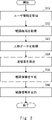
- FIG. 4 is a flow chart showing a route information providing method according to the first embodiment
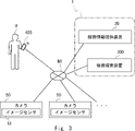
- 2 is a block diagram of a route information providing system according to a second embodiment
- FIG. 2 is a block diagram of a route information providing device according to a second embodiment
- FIG. 12 is a diagram illustrating an example of processing of a congestion degree calculation unit according to the second embodiment
- FIG. 2 is a block diagram of a route search device according to a second embodiment
- FIG. FIG. 8 is a block diagram of a user terminal according to the second embodiment
- FIG. It is a figure for showing an example of processing which a route search device performs.
- FIG. 4 is a first diagram showing an example of route information
- FIG. 4 is a second diagram showing an example of route information
- FIG. 11 is a third diagram showing an example of route information
- It is a block diagram which illustrates the hardware constitutions of a computer.
- FIG. 1 is a block diagram of the route information providing device 10 according to the first embodiment.
- a route information providing apparatus 10 according to this embodiment is communicably connected to a user terminal owned by a user.
- the route information providing device 10 presents to the user terminal a route to transportation facilities in the vicinity of the user's location.
- the route information providing device 10 has a user information acquisition unit 111, a route candidate acquisition unit 112, a congestion degree calculation unit 113, a route information generation unit 114, and an output unit 115 as main components.
- the user information acquisition unit 111 acquires user information from the user terminal.
- the user information includes location information of the user terminal owned by the user.
- the user information may include a user terminal identifier and a signal indicating that route guidance is desired. After acquiring the user information, the user information acquisition unit 111 supplies the acquired user information to the route candidate acquisition unit 112 .
- the route candidate acquisition unit 112 acquires, from the position information included in the user information, information about one or more route candidates connecting the position of the user terminal and boarding places of transportation facilities in the vicinity of the user terminal.
- the boarding place of transportation means, for example, a railway station, a bus stop, a taxi stand, or the like.
- the information about route candidates includes the route that connects the location of the user terminal (current position) to the boarding location of the transportation system, and the estimated travel time that would be required if the route was traveled at a predetermined speed. including.
- the predetermined speed is, for example, the normal human walking speed.
- the predetermined speed may be set for each user terminal.
- the route candidate acquisition unit 112 may have map information and a route search program.
- the route candidate acquisition unit 112 for example, searches for a boarding place of a transportation system located around the latitude and longitude of the user terminal, and searches for a route to the boarding place using map information. do.
- the route candidate acquisition unit 112 may communicate with a route search device existing outside the route information providing device 10 and acquire route candidates from the route search device. In this case, the route candidate acquisition unit 112 transmits the position information of the user terminal to the route search device and requests route candidates. When the route search device generates information about route candidates, the route candidate acquisition unit 112 acquires the route candidates from the route search device.
- the route candidate acquisition unit 112 When the route candidate acquisition unit 112 acquires route candidates by the method described above, the route candidate acquisition unit 112 supplies information about the acquired route candidates to the route information generation unit 114 .
- the congestion degree calculation unit 113 uses the person data on the candidate route to calculate the degree of congestion on the candidate route.
- Human data on the candidate route is acquired by a sensor installed on the candidate route. That is, the route information providing device 10 is communicably connected to the sensors installed on the route candidates.
- the person data on the candidate route is data for knowing the degree of congestion of people existing on the road, concourse, or other passageway that is the route candidate.
- Person data is, for example, image data obtained by imaging route candidates.
- the congestion level calculation unit 113 can calculate the congestion level of the place where the image data was obtained by measuring the number of people included in the image data.
- the congestion degree calculation unit 113 may measure the distance between persons from the image data, and calculate that the degree of congestion at that location is relatively high when the distance between persons is relatively small.
- the person data may also indicate the number of mobile terminals possessed by each person on the route candidate.
- the sensor acquires an identifier and location information transmitted by the mobile terminal, and generates data that allows estimation of the number of people on a predetermined route candidate.
- the format and aspect of the person data, the aspect of the sensor that generates the person data, and the like are not limited to those described above.
- the degree of congestion calculated by the degree-of-congestion calculation unit 113 is an index for relatively identifying the state of congestion of people in a predetermined place.
- the degree of congestion is indicated by a numerical value from 0% to 100%.
- a congestion degree of 0% indicates a state in which no person is detected in the place where the sensor is installed.
- a congestion degree of 100% indicates that the density of people (for example, the number of people per unit area) exceeds a predetermined threshold in the place where the sensor is installed.
- the congestion degree calculation unit 113 supplies the calculated congestion degree to the route information generation unit 114 .
- the route information generation unit 114 generates route information from the degree of congestion received from the degree of congestion calculation unit 113 and the information on route candidates received from the route candidate acquisition unit 112 .
- the route information includes information on recommended routes.
- the route information generation unit 114 can select a route with a low degree of congestion from among the plurality of route candidates as a recommended route.
- the route information generation unit 114 can select, from among the plurality of route candidates, a route that takes a short time to reach the boarding place of the transportation system, which is the destination, as the recommended route.
- the route information generation unit 114 may correct the required time by taking into consideration the degree of congestion of the candidate route to the estimated required time included in the information about the candidate route.
- the route information generation unit 114 selects the recommended route may be set in advance or may be set when the route information is generated. Also, the route information may include a plurality of recommended routes, and may rank the plurality of recommended routes. The route information may also include information on route candidates that have not been selected as recommended routes. After generating the route information, the route information generation unit 114 supplies the generated route information to the output unit 115 .
- the output unit 115 receives route information from the route information generation unit 114 and outputs the received route information. More specifically, the output unit 115, for example, transmits route information to user terminals that are communicably connected.
- FIG. 2 is a flow chart showing the route information providing method according to the first embodiment.
- the flowchart shown in FIG. 2 is started by starting the route information providing device 10, for example.
- the user information acquisition unit 111 acquires user information including location information of the user terminal owned by the user (step S11).
- the route candidate acquisition unit 112 acquires one or more route candidates connecting the current position of the user terminal and boarding places of transportation facilities in the vicinity of the user terminal based on the position information (step S12).
- the congestion degree calculation unit 113 acquires person data related to a person present on the route candidate from the sensor installed on the route candidate (step S13).
- the congestion degree calculation unit 113 calculates the degree of congestion of people on the candidate route from the acquired person data (step S14).
- the route information generation unit 114 generates route information regarding the recommended route from the route candidates based on the degree of congestion (step S15).
- the output unit 115 outputs the route information (step S16).
- the route information providing device 10 ends the series of processes.
- the route information providing device 10 has a processor and a storage device (not shown).
- the storage device of the route information providing device 10 includes, for example, a storage device including non-volatile memory such as flash memory and SSD (Solid State Drive).
- the storage device of the route information providing device 10 stores a computer program (hereinafter simply referred to as a program) for executing the image processing method described above.
- the processor also loads a computer program from a storage device into a buffer memory such as a DRAM (Dynamic Random Access Memory) and executes the program.
- a buffer memory such as a DRAM (Dynamic Random Access Memory)
- Each configuration of the route information providing device 10 may be realized by dedicated hardware. Also, part or all of each component may be implemented by a general-purpose or dedicated circuit, processor, etc., or a combination thereof. These may be composed of a single chip, or may be composed of multiple chips connected via a bus. A part or all of each component of each device may be implemented by a combination of the above-described circuits and the like and programs. Moreover, CPU (Central Processing Unit), GPU (Graphics Processing Unit), FPGA (field-programmable gate array), etc. can be used as a processor. It should be noted that the configuration descriptions described herein may also be applied to other devices or systems described below in the present disclosure.
- each component of the route information providing device 10 when part or all of each component of the route information providing device 10 is realized by a plurality of route information providing devices, circuits, etc., the plurality of route information providing devices, circuits, etc. may be centrally arranged. may be distributed.
- the route information providing device, circuit, etc. may be implemented as a client-server system, a cloud computing system, or the like, each of which is connected via a communication network.
- the functions of the route information providing device 10 may be provided in a SaaS (Software as a Service) format.
- Embodiment 1 has been described above. According to Embodiment 1, it is possible to provide a route information providing apparatus or the like that accurately determines the degree of congestion with a simple configuration.
- FIG. 3 is a block diagram of a route information providing system according to a second embodiment.
- FIG. 3 shows a state in which the route information providing system 1, the camera 50 and the user terminal 400 are each communicably connected to the network N1.
- the route information providing system 1 includes a route information providing device 20 and a route search device 300.
- a route information providing system 1 according to the present embodiment is connected to a user terminal 400 owned by a user U and a plurality of cameras 50 so as to be communicable.
- the route information providing system 1 acquires user information from the user terminal 400 possessed by the user U, and acquires image data from the camera 50 .
- the route information providing system 1 presents to the user terminal 400 a route to transportation facilities around the position where the user U exists, based on the acquired user information and image data.
- the route information providing system 1 may include a camera 50 .
- the camera 50 captures the scenery of the place where it is installed, generates image data, and supplies the generated image data to the route information providing system 1 via the network N1.
- Camera 50 includes an image sensor 51 . That is, the camera 50 is an embodiment of a sensor installed on a candidate route for the route information providing system 1 to calculate the degree of crowding of people at the place where the camera 50 is installed.
- Each camera 50 has a unique identifier.
- the camera 50 supplies the image data to the route information providing system 1 in such a manner that the identifier of each camera 50 can be identified.
- the route information providing system 1 can associate each camera 50 with the installation location.
- FIG. 4 is a block diagram of the route information providing device 20 according to the second embodiment.
- the route information providing device 20 differs from the route information providing device 10 according to the first embodiment in that it has an updating unit 116 and a storage unit 120 .
- the update unit 116 causes the congestion degree calculation unit 113 to update the congestion degree of the candidate route in response to a predetermined request signal.
- the predetermined request signal may be, for example, a request signal received from the user terminal 400, or may be set at predetermined intervals (eg, 30 seconds, 60 seconds, or 90 seconds).
- the update unit 116 supplies a signal instructing the congestion degree calculation unit 113 to update the congestion degree.
- the congestion degree calculation unit 113 acquires human data from the sensor installed on the route candidate, calculates the congestion degree, and supplies the calculated congestion degree to the route information generation unit 114 . .
- the route information generator 114 generates route information including the updated congestion degree and supplies the updated route information to the output unit 115 . Furthermore, the output unit 115 outputs the updated route information. Thereby, the route information providing device 20 can suitably present the user U with the degree of congestion of the route candidates.
- the route candidate acquisition unit 112 in the present embodiment is communicably connected to the route search device 300 and acquires information on route candidates from the route search device 300 .
- the route candidate acquisition unit 112 transmits the position information of the user terminal to the route search device and requests route candidates.
- the route candidate acquisition unit 112 acquires the route candidates from the route search device.
- the user information acquired by the user information acquisition unit 111 may include the time tolerance regarding the required time allowed by the user.
- the time tolerance is an index related to the time allowed by the user to reach the boarding place of a predetermined transportation system.
- the route information generation unit 114 generates route information using user information including the time tolerance in addition to the degree of congestion.
- the time tolerance may be a specific time such as 10 minutes or 30 minutes.
- the route information generation unit 114 selects, as a recommended route, a route candidate whose estimated required time is shorter than the time specified as the time tolerance in addition to the degree of congestion.
- the time tolerance may be an abstract and relative identification symbol such as "hurry” or "slowly". For example, when the time tolerance is "hurry", the route information generator 114 selects a route candidate with a short estimated required time as a recommended route. On the other hand, for example, when the time tolerance is "slow", the route information generation unit 114 extracts a plurality of route candidates in order from the route candidate with the shortest estimated required time, and adds the degree of congestion of the extracted plurality of route candidates. to select the recommended route.
- the user information acquired by the user information acquisition unit 111 in the present embodiment may include priority information indicating either the required time priority or the congestion avoidance priority.
- the route information generation unit 114 generates route information using the degree of congestion and priority information included in the user information.
- the route information generating unit 114 when the route information generating unit 114 acquires information indicating priority of required time as priority information, it selects a route candidate with a relatively short required time as a recommended route. Further, when the route information generation unit 114 acquires information indicating congestion avoidance priority as the priority information, the route information generation unit 114 selects a route candidate with a relatively low degree of congestion as a recommended route.
- the congestion degree calculation unit 113 in the present embodiment acquires image data obtained by photographing the scenery of the route candidate from the camera 50 as person data.
- the congestion level calculation unit 113 can, for example, recognize a person image included in this image data, count the number of people present in the captured scenery from the recognized person image, and calculate the congestion level.
- the congestion degree calculation unit 113 may have a trained model trained to derive the congestion degree from the image data, for example, and may calculate the congestion degree by inputting the image data into this trained model.
- the congestion degree calculation unit 113 may also recognize traffic areas such as roads and concourses where people pass, and calculate the congestion degree from the number of people in this traffic area.
- the congestion degree calculation unit 113 may measure the moving speed of a person included in the image data using image data generated at a plurality of different times, and use the measured moving speed to calculate the congestion degree. . That is, for example, the congestion degree calculation unit 113 calculates the degree of congestion when the moving speed of people in an image with a certain number of people X1 is relatively fast, and the congestion degree when the moving speed of people in an image with the same number of people X1 is relatively high. Set it lower than the degree of congestion when it is slow. On the other hand, the congestion degree calculation unit 113 sets the congestion degree when the moving speed of the person is relatively slow to be higher than the congestion degree when the moving speed of the person is relatively fast.
- the congestion degree calculation unit 113 may also measure the distance between persons (inter-person distance) included in the image data, and calculate the congestion degree using the measured inter-person distance. For example, the congestion degree calculation unit 113 measures the distances between the closest persons and calculates the average of these distances. Then, the congestion degree calculation unit 113 uses the calculated average value of the inter-person distances when calculating the congestion degree. For example, when the average value of the inter-person distances in an image in which a certain number of people X1 are present is relatively small, the number of persons in the image is relatively large compared to the case where the average value of inter-person distances in an image in which the number of people X1 is present is relatively large. are densely present. Therefore, in this case, the congestion degree calculation unit 113 sets the congestion degree when the inter-person distance is relatively small higher than the congestion degree when the inter-person distance is relatively large.
- the route information generated by the route information generation unit 114 in this embodiment includes route congestion degree information regarding the degree of congestion of multiple route candidates including the recommended route.
- the route information providing device 20 can suitably present the user U with the congestion situation in the surrounding area.
- the user U using the route information providing system 1 can receive information on a plurality of route candidates including a recommended route and actively select a route. Therefore, the route information providing device 20 can provide highly convenient route information.
- the route information generated by the route information generation unit 114 may include superimposed image data in which map information related to the route candidate and information regarding the degree of congestion of the route are superimposed.
- the route information providing device 20 can provide easy-to-recognize route information. That is, on the user terminal 400, the user U can visually recognize information in which the user's own location, nearby transportation boarding locations, and route candidates including the degree of congestion are superimposed on a map.
- FIG. 5 is a diagram illustrating an example of processing of the congestion degree calculation unit 113 according to the second embodiment.
- the drawing shows a data group input to the congestion degree calculation unit 113 and a data group output from the congestion degree calculation unit 113 .
- the congestion degree calculation unit 113 receives image data generated by the camera 50, position information linked to the camera 50, and the time when the camera 50 captured the image corresponding to the image data as the input data group. and accept. That is, the input data group is person data.
- the congestion degree calculation unit 113 outputs the congestion degree, position information, and time from these input data groups as an output data group.
- the congestion degree calculation unit 113 supplies the output data group to the route information generation unit 114 .
- the congestion degree calculation unit 113 acquires the image data supplied from the camera 50 as the person data, but the person data is not limited to this.
- the person data acquired by the congestion degree calculation unit 113 may include the position data of the portable terminal carried by the person on the candidate route.
- the sensors installed on the route candidates receive position information and unique identifiers transmitted by mobile terminals existing around the sensors. Accordingly, the congestion level calculation unit 113 estimates the number of people present around the sensor, their moving speed, and the like, and calculates the congestion level.
- the person data acquired by the congestion degree calculation unit 113 may include temperature or humidity measurement data on route candidates.
- the sensors installed on the route candidates measure the temperature or humidity in the path along which the person travels, and obtain the temperature or humidity in places around the path. Accordingly, the congestion degree calculation unit 113 measures whether or not the temperature and humidity of the road have risen above the temperature and humidity of the surrounding area, and calculates the degree of congestion from the difference in temperature and humidity.
- the person data acquired by the congestion degree calculation unit 113 may include voice data of voices uttered by people on route candidates.
- the sensors installed on the route candidates collect audio data such as utterances of people passing through the road and footsteps while walking. Accordingly, the congestion level calculation unit 113 calculates the congestion level by measuring the volume of the voice on the road.
- the person data acquired by the congestion degree calculation unit 113 is data regarding the number of posts and the posting frequency of specific text information related to the congestion degree among text information posted on a social network service (SNS) or a predetermined website. may include.
- Person data may include a plurality of the above data.
- FIG. 6 is a block diagram of the route search device 300 according to the second embodiment.
- the route search device 300 uses the user information of the user terminal 400 to search for a route connecting the user terminal 400 and boarding places of transportation facilities in the vicinity thereof, generates route candidates, and provides information about the generated route candidates. It is supplied to the route information providing device 20 .
- the route search device 300 may be a personal computer, a server, an arithmetic processing device for route search, or the like.
- the route search device 300 has a communication section 311, a route search section 312, a control section 313 and a storage section 320 as main components.
- the communication unit 311 is an interface for performing communication between the route searching device 300 and the route information providing device 20. For example, the communication unit 311 receives the location information of the user terminal 400 from the route information providing device 20 via the network N1. The communication unit 311 also transmits information about the route candidates generated via the network N1 to the route information providing device 20 .
- the route search unit 312 searches for one or more routes from the location information of the user terminal 400 to a boarding place of a transportation facility near the user terminal 400, and generates information about route candidates.
- the control unit 313 includes an arithmetic device such as a CPU, and controls each component of the route search device 300 .
- the control unit 414 reads a program from the storage unit 420 and implements a predetermined function according to the read program.
- the storage unit 320 is a storage device including a non-volatile memory, and stores at least a program and map information for causing the route search device 300 to implement the functions of the present embodiment.
- FIG. 7 is a block diagram of the user terminal 400 according to the second embodiment.
- the user terminal 400 may be a mobile phone, smart phone, tablet terminal, or the like.
- the user terminal 400 has a display section 411 , a position information generation section 412 , a communication section 413 , a control section 414 and a storage section 420 as main components.
- the display unit 411 is a display device including, for example, a liquid crystal panel or an organic electroluminescence panel, and displays predetermined information so that the user can see it.
- the display unit 411 displays, for example, route information that the route information providing system 1 outputs to the user terminal 400 .
- the location information generation unit 412 generates information regarding the location of the user terminal 400 .
- the location information generator 412 may acquire location information by GNSS (Global Navigation Satellite System).
- GNSS Global Navigation Satellite System
- the communication unit 413 is an interface for performing communication between the user terminal 400 and the route information providing system 1. For example, the communication unit 413 transmits the location information of the user terminal 400, the identifier of the user terminal 400, and the like to the route information providing system 1 via the network N1. Also, for example, the communication unit 413 receives route information output by the route information providing system 1 .
- the control unit 414 includes an arithmetic device such as a CPU, and controls each component of the user terminal 400 .
- the control unit 414 reads a program from the storage unit 420 and implements a predetermined function according to the read program.
- the storage unit 420 is a storage device including a non-volatile memory, and stores at least a program for causing the user terminal 400 to implement the functions of the present embodiment.
- Such programs may include, for example, an application program for the user terminal 400 to display route information.
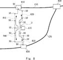
- FIG. 8 is a diagram for showing a specific example of processing performed by the route search device.
- FIG. 8 shows a map of the surroundings of the user U's location.
- User U is located near building A10.
- the building A10 is, for example, a place where many people gather, such as a concert hall or a stadium. After the event ends, the user U is going home from here using a nearby transportation system.
- the first line C10 includes the first station B10.
- the second line C20 includes a second station B20.
- the first line C10 and the second line C20 merge at the third station B30, and continue beyond that point while continuing to merge.
- stations relatively close to the location where the user U is present are the first station B1 and the second station B20.
- a first route R10 and a second route R20 exist as routes connecting the location where the user U exists to the first station. Further, as routes connecting the place where the user U exists to the second station B20, there are a third route R30 and a fourth route R40. A plurality of cameras 50 are installed on the routes of the first route R10, the second route R20, the third route R30 and the fourth route 40. As shown in FIG.
- the user U uses the user terminal 400 to use the route information providing system 1.
- the user U performs an operation requesting the route information providing system 1 to guide the route to the boarding place of the surrounding transportation.
- FIG. 9 is a first diagram showing an example of route information.
- FIG. 9 shows a first image P11 displayed by the display device of the user terminal 400. As shown in FIG. The image P11 is displayed by superimposing an icon U10 representing the user U, a building A10, a first station B10 and a second station B20 on a map of the vicinity of the location where the user U exists.
- the route information providing system 1 generates route information prioritizing required time or route information prioritizing avoidance of congestion according to user U's selection.
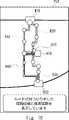
- FIG. 10 is a second diagram showing an example of route information.
- FIG. 10 shows the second image P12 displayed by the display device of the user terminal 400. As shown in FIG. The second image P12 shows a state in which the route information providing system 1 generates route information and the user terminal 400 displays the route information after the user U selects "avoid congestion" in the first image P11 shown in FIG. showing.
- the first route R10, the second route R20 and the third route R30 are indicated by dotted lines, and the fourth route R40 is indicated by a thick solid line.
- the locations where the cameras 50 are installed are marked with circular symbols having different diameters.
- the second image P12 also displays messages such as "route found" and "route candidates and recommended routes are displayed”.
- the round symbols shown in the second image P12 indicate the degree of congestion at each location where the camera 50 is installed.
- the diameter of the circle is associated with the degree of congestion. That is, the larger the diameter of the round symbol, the more crowded the location.
- the diameter of the round symbol attached to the fourth route R40 is smaller than that of the other route candidates. That is, the fourth route R40 is less crowded than other route candidates. Therefore, the route information providing system 1 selects the fourth route R40 as the recommended route and displays it with a solid line.
- FIG. 11 is a third diagram showing an example of route information.
- FIG. 11 shows the third image P13 displayed by the display device of the user terminal 400. As shown in FIG. The third image P13 shows a state in which the user U who viewed the second image P12 shown in FIG. 10 selects the fourth route R40 and is proceeding.
- an icon U10 representing the user U is located in the middle of the fourth route R40.
- a route connecting the icon U10 and the second station B20 is indicated by a thick solid line. Route candidates that the user U did not select are indicated by bold white lines.
- the third image P13 displays the message "The latest congestion status is being displayed.”
- the degree of congestion at the place where the camera 50 is installed has changed from the second image P12 shown in FIG. That is, in the route information providing system 1, the updating unit 116 of the route information providing device 20 generates a signal for updating the degree of congestion every 30 seconds, for example. Along with this, the route information generator 114 generates route information including the updated congestion degree. This route information also includes the degree of congestion in route candidates that the user U did not select. With such a configuration, the route information providing system 1 generates information according to changes in circumstances and presents it to the user U. FIG. Therefore, the user U can use route guidance while recognizing updated information.
- the route information providing system 1 is not limited to the configuration described above.
- the user information acquisition unit 111 may further acquire information regarding the destination to which the user is heading.
- the route candidate acquisition unit 112 acquires, as a route candidate, a route for the user to reach the destination using transportation.
- user U requests route guidance for a route to a destination such as home or office.
- the route information providing system 1 guides the route to the destination via transportation.
- the second embodiment has been described above. According to the route information providing system 1 or the route information providing device 20 according to the second embodiment, it is possible to provide a route information providing device, a route information providing method and a program for efficiently using traffic facilities.
- FIG. 12 is a block diagram illustrating the hardware configuration of a computer.
- the route information providing device can realize the functions described above by a computer 500 including the hardware configuration shown in the figure.
- the computer 500 may be a portable computer such as a smart phone or a tablet terminal, or may be a stationary computer such as a PC.
- Computer 500 may be a dedicated computer designed to implement each device, or may be a general-purpose computer.
- the computer 500 can implement desired functions by installing predetermined applications.
- Computer 500 has bus 502 , processor 504 , memory 506 , storage device 508 , input/output interface (I/F) 510 and network interface (I/F) 512 .
- the bus 502 is a data transmission path through which the processor 504, memory 506, storage device 508, input/output interface 510, and network interface 512 exchange data with each other.
- the method of connecting the processors 504 and the like to each other is not limited to bus connection.
- the processor 504 is various processors such as CPU, GPU or FPGA.
- the memory 506 is a main memory implemented using a RAM (Random Access Memory) or the like.
- the storage device 508 is an auxiliary storage device realized using a hard disk, SSD, memory card, ROM (Read Only Memory), or the like.
- the storage device 508 stores programs for realizing desired functions.
- the processor 504 reads this program into the memory 506 and executes it, thereby realizing each functional component of each device.
- the input/output interface 510 is an interface for connecting the computer 500 and input/output devices.
- the input/output interface 510 is connected to an input device such as a keyboard and an output device such as a display device.
- a network interface 512 is an interface for connecting the computer 500 to a network.
- User information acquisition means for acquiring user information including location information of a user terminal owned by a user;
- Route candidate acquisition means for acquiring one or more route candidates connecting the current position of the user terminal and a boarding place of a transportation system in the vicinity of the user terminal based on the position information;
- congestion level calculation means for acquiring person data related to a person existing on the route candidate from a sensor installed on the route candidate, and calculating a congestion level of people on the route candidate from the acquired person data; route information generating means for generating route information regarding a recommended route from the route candidates based on the degree of congestion; and output means for outputting the route information.
- the user information acquired by the user information acquisition means further includes a time tolerance related to the required time allowed by the user, The route information generating means generates the route information based on the user information including the degree of congestion and the time tolerance.
- the route information providing device according to appendix 1. (Appendix 3)
- the user information acquired by the user information acquisition means further includes priority information indicating either the required time priority or the congestion avoidance priority, The route information generating means generates the route information based on the degree of congestion and the user information including the priority information.
- the route information generating means is selecting the route candidate with a relatively short required time as the recommended route when the information indicating the required time priority is acquired as the priority information; selecting the route candidate with the relatively low degree of congestion as the recommended route when the information indicating the congestion avoidance priority is acquired as the priority information;
- the route information providing device according to appendix 3.
- the congestion degree calculation means acquires image data of the scenery of the route candidate as the person data.
- the route information providing device according to any one of Appendices 1 to 4.
- the route information providing apparatus calculates the congestion level based on a moving speed of a person included in the image data.
- the person data acquired by the congestion degree calculation means includes position data of a mobile terminal carried by a person on the route candidate, The route information providing device according to any one of Appendices 1 to 8.
- the person data acquired by the congestion degree calculation means includes measurement data of temperature or humidity in the route candidate, The route information providing device according to any one of Appendices 1 to 9.
- the person data acquired by the congestion degree calculation means includes voice data of a voice uttered by a person on the route candidate, The route information providing device according to any one of Appendices 1 to 10.
- the route information generated by the route information generating means includes route congestion degree information regarding the degree of congestion of the plurality of route candidates including the recommended route, The route information providing device according to any one of Appendices 1 to 11.
- the route information generated by the route information generating means includes superimposed image data obtained by superimposing map information on the route candidate and information on the degree of congestion of the route, The route information providing device according to any one of Appendices 1 to 12.
- (Appendix 14) further comprising updating means for updating the degree of congestion in the candidate route in response to a predetermined request signal;
- the route information generating means generates the route information including the updated congestion degree.
- the route information providing device according to any one of Appendices 1 to 13.
- the user information acquisition means further acquires information regarding a destination to which the user is heading,
- the route candidate acquisition means acquires, as the route candidate, a route for the user to reach the destination using the transportation system.
- the route information providing device according to any one of Appendices 1 to 14.
- the route information providing device according to any one of Appendices 1 to 15; a route search device that searches for a route connecting the user terminal and a boarding place of the transportation system in the vicinity of the user terminal based on the user information and generates the route candidate; Route information system.
- (Appendix 18) obtaining user information including location information of the user terminal and time tolerance of the user; searching for one or more route candidates connecting the current position of the user terminal and a boarding place for transportation in the vicinity of the user terminal based on the position information; Acquiring person data on a plurality of persons from a sensor installed on the route candidate, calculating a degree of congestion of persons on the route candidate from the acquired person data, outputting information about a recommended route selected from the route candidates based on the time tolerance and the congestion degree; A program that causes a computer to execute a route information provision method.
- Non-transitory computer-readable media include various types of tangible storage media.
- non-transitory computer-readable media examples include magnetic recording media (eg, flexible discs, magnetic tapes, hard disk drives), magneto-optical recording media (eg, magneto-optical discs), CD-ROM (Read Only Memory) CD-R, CD - R/W, including semiconductor memory (eg, mask ROM, PROM (Programmable ROM), EPROM (Erasable PROM), flash ROM, RAM (Random Access Memory)).
- the program may also be supplied to the computer on various types of transitory computer readable medium. Examples of transitory computer-readable media include electrical signals, optical signals, and electromagnetic waves. Transitory computer-readable media can deliver the program to the computer via wired channels, such as wires and optical fibers, or wireless channels.
- route information providing system 10 route information providing device 20 route information providing device 50 camera 51 image sensor 111 user information acquisition unit 112 route candidate acquisition unit 113 congestion degree calculation unit 114 route information generation unit 115 output unit 116 update unit 120 storage unit 300 Route search device 311 communication unit 312 route search unit 313 control unit 320 storage unit 400 user terminal 411 display unit 412 position information generation unit 413 communication unit 414 control unit 420 storage unit 500 computer 502 bus 504 processor 506 memory 508 storage device 510 input/output interface 512 network I/F
Landscapes
- Engineering & Computer Science (AREA)
- Radar, Positioning & Navigation (AREA)
- Remote Sensing (AREA)
- Physics & Mathematics (AREA)
- General Physics & Mathematics (AREA)
- Automation & Control Theory (AREA)
- Navigation (AREA)
Priority Applications (1)
| Application Number | Priority Date | Filing Date | Title |
|---|---|---|---|
| JP2023508674A JP7635825B2 (ja) | 2021-03-23 | 2022-01-17 | 経路情報提供装置、経路情報提供方法およびプログラム |
Applications Claiming Priority (2)
| Application Number | Priority Date | Filing Date | Title |
|---|---|---|---|
| JP2021-049221 | 2021-03-23 | ||
| JP2021049221 | 2021-03-23 |
Publications (1)
| Publication Number | Publication Date |
|---|---|
| WO2022201779A1 true WO2022201779A1 (ja) | 2022-09-29 |
Family
ID=83396796
Family Applications (1)
| Application Number | Title | Priority Date | Filing Date |
|---|---|---|---|
| PCT/JP2022/001406 Ceased WO2022201779A1 (ja) | 2021-03-23 | 2022-01-17 | 経路情報提供装置、経路情報提供システム、経路情報提供方法およびコンピュータ可読媒体 |
Country Status (2)
| Country | Link |
|---|---|
| JP (1) | JP7635825B2 (https=) |
| WO (1) | WO2022201779A1 (https=) |
Citations (9)
| Publication number | Priority date | Publication date | Assignee | Title |
|---|---|---|---|---|
| JPH06201389A (ja) * | 1993-01-05 | 1994-07-19 | Fujitsu Ten Ltd | 経路探索装置 |
| JP2002189827A (ja) * | 2000-12-20 | 2002-07-05 | Fuji Xerox Co Ltd | エリア情報提供システム |
| JP2004257829A (ja) * | 2003-02-25 | 2004-09-16 | Denso Corp | 車両用ナビゲーションシステム |
| JP2006047274A (ja) * | 2004-07-07 | 2006-02-16 | East Japan Railway Co | 経路誘導システム |
| WO2009054119A1 (ja) * | 2007-10-26 | 2009-04-30 | Panasonic Corporation | 状況判定装置、状況判定方法、状況判定プログラム、異常判定装置、異常判定方法、異常判定プログラムおよび混雑推定装置 |
| JP2009162702A (ja) * | 2008-01-10 | 2009-07-23 | Sharp Corp | ナビゲーションシステム、ナビゲーションサーバ及び携帯電話機 |
| JP2009271023A (ja) * | 2008-05-12 | 2009-11-19 | Nec Corp | 経路探索装置 |
| JP2019036304A (ja) * | 2017-08-18 | 2019-03-07 | 能美防災株式会社 | 防災システム |
| JP2019179045A (ja) * | 2019-07-25 | 2019-10-17 | アイシン・エィ・ダブリュ株式会社 | 経路探索システム、経路探索方法及びコンピュータプログラム |
Family Cites Families (4)
| Publication number | Priority date | Publication date | Assignee | Title |
|---|---|---|---|---|
| JPH09305107A (ja) * | 1996-05-17 | 1997-11-28 | Sony Corp | ナビゲーション装置 |
| JP2017033266A (ja) | 2015-07-31 | 2017-02-09 | セイコーエプソン株式会社 | 電子機器、システム、情報通知方法、及び情報通知プログラム |
| JP6674791B2 (ja) | 2016-02-17 | 2020-04-01 | 株式会社Screenホールディングス | 混雑度推定方法、人数推定方法、混雑度推定プログラム、人数推定プログラム、および人数推定システム |
| JP2020008969A (ja) | 2018-07-04 | 2020-01-16 | パナソニックIpマネジメント株式会社 | 情報提供システム、情報提供サーバー、及び情報提供方法 |
-
2022
- 2022-01-17 WO PCT/JP2022/001406 patent/WO2022201779A1/ja not_active Ceased
- 2022-01-17 JP JP2023508674A patent/JP7635825B2/ja active Active
Patent Citations (9)
| Publication number | Priority date | Publication date | Assignee | Title |
|---|---|---|---|---|
| JPH06201389A (ja) * | 1993-01-05 | 1994-07-19 | Fujitsu Ten Ltd | 経路探索装置 |
| JP2002189827A (ja) * | 2000-12-20 | 2002-07-05 | Fuji Xerox Co Ltd | エリア情報提供システム |
| JP2004257829A (ja) * | 2003-02-25 | 2004-09-16 | Denso Corp | 車両用ナビゲーションシステム |
| JP2006047274A (ja) * | 2004-07-07 | 2006-02-16 | East Japan Railway Co | 経路誘導システム |
| WO2009054119A1 (ja) * | 2007-10-26 | 2009-04-30 | Panasonic Corporation | 状況判定装置、状況判定方法、状況判定プログラム、異常判定装置、異常判定方法、異常判定プログラムおよび混雑推定装置 |
| JP2009162702A (ja) * | 2008-01-10 | 2009-07-23 | Sharp Corp | ナビゲーションシステム、ナビゲーションサーバ及び携帯電話機 |
| JP2009271023A (ja) * | 2008-05-12 | 2009-11-19 | Nec Corp | 経路探索装置 |
| JP2019036304A (ja) * | 2017-08-18 | 2019-03-07 | 能美防災株式会社 | 防災システム |
| JP2019179045A (ja) * | 2019-07-25 | 2019-10-17 | アイシン・エィ・ダブリュ株式会社 | 経路探索システム、経路探索方法及びコンピュータプログラム |
Also Published As
| Publication number | Publication date |
|---|---|
| JP7635825B2 (ja) | 2025-02-26 |
| JPWO2022201779A1 (https=) | 2022-09-29 |
Similar Documents
| Publication | Publication Date | Title |
|---|---|---|
| JP5243896B2 (ja) | 情報表示システム、情報表示方法、および、コンピュータプログラム | |
| EP3660458A1 (en) | Information providing system, server, onboard device, and information providing method | |
| JP2007066106A (ja) | 経路案内装置 | |
| JP5238422B2 (ja) | 情報提供システム | |
| JP7433380B2 (ja) | 経路評価装置、経路評価方法および経路評価プログラム | |
| JP6470010B2 (ja) | 情報処理システム、情報処理プログラム、情報処理装置、および情報処理方法 | |
| KR101886966B1 (ko) | 맞춤형 여행계획 제공 방법 및 이를 수행하는 서버 | |
| KR101280313B1 (ko) | 스마트 버스정보시스템 | |
| US11181381B2 (en) | Portable pedestrian navigation system | |
| JP2019020172A (ja) | 経路提案装置および経路提案方法 | |
| JP7494640B2 (ja) | サーバ装置、情報処理システム、プログラム、及び情報処理システムの動作方法 | |
| JP7635825B2 (ja) | 経路情報提供装置、経路情報提供方法およびプログラム | |
| CN105115496B (zh) | 一种室内路线推荐方法及移动终端 | |
| JP5053135B2 (ja) | 交通情報表示システム、交通情報表示サーバ、交通情報表示方法、および、コンピュータプログラム | |
| JP2019027790A (ja) | 情報処理装置、情報処理システム、情報処理方法及びプログラム | |
| JP5956120B2 (ja) | 情報処理システム、情報処理装置、情報処理プログラムおよび情報処理方法 | |
| WO2015114955A1 (ja) | 情報提供システム及び方法 | |
| JP6419603B2 (ja) | 情報処理装置、位置表示システム | |
| JP2008152364A (ja) | 情報提供装置、情報提供方法、情報提供プログラム、およびコンピュータに読み取り可能な記録媒体 | |
| WO2022201722A1 (ja) | 情報表示プログラム、情報表示装置および情報表示方法 | |
| WO2022201720A1 (ja) | 情報提示方法 | |
| JP6658748B2 (ja) | 経路管理システム、経路管理方法及びコンピュータ読み取り可能記録媒体 | |
| JP2016057213A (ja) | 経路誘導システム | |
| JPWO2016052237A1 (ja) | 情報処理装置、その制御方法、およびプログラム | |
| JPWO2014162612A1 (ja) | 情報提供システム、端末、情報提供方法および情報提供プログラム |
Legal Events
| Date | Code | Title | Description |
|---|---|---|---|
| 121 | Ep: the epo has been informed by wipo that ep was designated in this application |
Ref document number: 22774583 Country of ref document: EP Kind code of ref document: A1 |
|
| WWE | Wipo information: entry into national phase |
Ref document number: 2023508674 Country of ref document: JP |
|
| NENP | Non-entry into the national phase |
Ref country code: DE |
|
| 122 | Ep: pct application non-entry in european phase |
Ref document number: 22774583 Country of ref document: EP Kind code of ref document: A1 |