WO2022201779A1 - Route information provision device, route information provision system, route information provision method, and computer-readable medium - Google Patents
Route information provision device, route information provision system, route information provision method, and computer-readable medium Download PDFInfo
- Publication number
- WO2022201779A1 WO2022201779A1 PCT/JP2022/001406 JP2022001406W WO2022201779A1 WO 2022201779 A1 WO2022201779 A1 WO 2022201779A1 JP 2022001406 W JP2022001406 W JP 2022001406W WO 2022201779 A1 WO2022201779 A1 WO 2022201779A1
- Authority
- WO
- WIPO (PCT)
- Prior art keywords
- route
- information
- congestion
- user
- route information
- Prior art date
Links
- 238000000034 method Methods 0.000 title claims description 15
- 238000004364 calculation method Methods 0.000 claims abstract description 58
- 230000004044 response Effects 0.000 claims description 4
- 238000005259 measurement Methods 0.000 claims description 3
- 238000010586 diagram Methods 0.000 description 21
- 238000004891 communication Methods 0.000 description 13
- 230000006870 function Effects 0.000 description 8
- 230000010365 information processing Effects 0.000 description 4
- 238000004590 computer program Methods 0.000 description 3
- 238000005516 engineering process Methods 0.000 description 3
- 238000003672 processing method Methods 0.000 description 2
- 230000005540 biological transmission Effects 0.000 description 1
- 238000005401 electroluminescence Methods 0.000 description 1
- 239000000284 extract Substances 0.000 description 1
- 238000000605 extraction Methods 0.000 description 1
- 238000003384 imaging method Methods 0.000 description 1
- 238000009434 installation Methods 0.000 description 1
- 239000004973 liquid crystal related substance Substances 0.000 description 1
- 230000003287 optical effect Effects 0.000 description 1
- 239000013307 optical fiber Substances 0.000 description 1
- 239000004065 semiconductor Substances 0.000 description 1
- 239000007787 solid Substances 0.000 description 1
Images


Classifications
-
- G—PHYSICS
- G01—MEASURING; TESTING
- G01C—MEASURING DISTANCES, LEVELS OR BEARINGS; SURVEYING; NAVIGATION; GYROSCOPIC INSTRUMENTS; PHOTOGRAMMETRY OR VIDEOGRAMMETRY
- G01C21/00—Navigation; Navigational instruments not provided for in groups G01C1/00 - G01C19/00
- G01C21/26—Navigation; Navigational instruments not provided for in groups G01C1/00 - G01C19/00 specially adapted for navigation in a road network
-
- G—PHYSICS
- G08—SIGNALLING
- G08G—TRAFFIC CONTROL SYSTEMS
- G08G1/00—Traffic control systems for road vehicles
- G08G1/005—Traffic control systems for road vehicles including pedestrian guidance indicator
-
- G—PHYSICS
- G08—SIGNALLING
- G08G—TRAFFIC CONTROL SYSTEMS
- G08G1/00—Traffic control systems for road vehicles
- G08G1/01—Detecting movement of traffic to be counted or controlled
Definitions
- the present invention relates to a route information providing device, a route information providing system, a route information providing method, and a computer-readable medium.
- an information processing system acquires congestion information of a candidate for use station extracted by a candidate for use station extraction means, and when a candidate for use station is congested, an alternative use station that can be substituted for a candidate for use station that is congested. Get an alternative route using
- Patent Document 2 acquires the number of people who can board at each station from the operation status of the route, calculates the number of people who cannot board at each station as the required amount of stay, and guides people to the selected guide destination stay area. Distribute guidance information for
- the route search tool (Patent Document 3) dynamically searches for route candidates when it receives search conditions that include a departure station, a destination station, and an allowable walking time that indicates the time the user is allowed to travel on foot. At that time, if the intermediate station is a station that can be reached on foot and the required time between stations associated with that station is less than the allowable walking time, search for route candidates including the walking section connecting the station and nearby stations. enable If the route candidate specified by the route search includes a walking section, the walking section is specified and output in the map information around the station.
- An object of the present invention is to provide a route information providing device, a route information providing method, and a program for efficiently using transportation facilities in view of the above-mentioned problems.
- a route information providing device includes a user information acquisition unit, a route candidate acquisition unit, a congestion degree calculation unit, a route information generation unit, and an output unit.
- the user information acquisition unit acquires user information including location information of a user terminal owned by the user.
- the route candidate acquisition unit acquires information on one or more route candidates connecting the current position of the user terminal and a boarding place of a transportation system in the vicinity of the user terminal based on the position information.
- the congestion degree calculation unit acquires human data related to a person present on the route candidate from a sensor installed on the route candidate, and calculates the human congestion degree on the route candidate from the acquired human data.
- the route information generation unit generates route information regarding the recommended route from the route candidates based on the degree of congestion.
- the output unit outputs route information.
- a computer executes the following method in a route information providing method according to an embodiment of the present disclosure.
- the computer acquires user information including location information of a user terminal owned by the user. Based on the position information, the computer obtains information about one or more route candidates connecting the current position of the user terminal and a boarding place for transportation in the vicinity of the user terminal.
- the computer acquires person data on a person present on the route candidate from the sensor installed on the route candidate.
- the computer calculates the degree of crowding of people on the candidate route from the acquired human data.
- a computer generates route information about a recommended route from route candidates based on the degree of congestion. The computer outputs route information.
- a program causes a computer to execute the following steps.
- the computer acquires user information including location information of a user terminal owned by the user. Based on the position information, the computer obtains information about one or more route candidates connecting the current position of the user terminal and a boarding place for transportation in the vicinity of the user terminal.
- the computer acquires person data on a person present on the route candidate from the sensor installed on the route candidate.
- the computer calculates the degree of crowding of people on the candidate route from the acquired human data.
- a computer generates route information about a recommended route from route candidates based on the degree of congestion. The computer outputs route information.
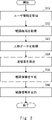
- FIG. 1 is a block diagram of a route information providing device according to a first exemplary embodiment
- FIG. 4 is a flow chart showing a route information providing method according to the first embodiment
- 2 is a block diagram of a route information providing system according to a second embodiment
- FIG. 2 is a block diagram of a route information providing device according to a second embodiment
- FIG. 12 is a diagram illustrating an example of processing of a congestion degree calculation unit according to the second embodiment
- FIG. 2 is a block diagram of a route search device according to a second embodiment
- FIG. FIG. 8 is a block diagram of a user terminal according to the second embodiment
- FIG. It is a figure for showing an example of processing which a route search device performs.
- FIG. 4 is a first diagram showing an example of route information
- FIG. 4 is a second diagram showing an example of route information
- FIG. 11 is a third diagram showing an example of route information
- It is a block diagram which illustrates the hardware constitutions of a computer.
- FIG. 1 is a block diagram of the route information providing device 10 according to the first embodiment.
- a route information providing apparatus 10 according to this embodiment is communicably connected to a user terminal owned by a user.
- the route information providing device 10 presents to the user terminal a route to transportation facilities in the vicinity of the user's location.
- the route information providing device 10 has a user information acquisition unit 111, a route candidate acquisition unit 112, a congestion degree calculation unit 113, a route information generation unit 114, and an output unit 115 as main components.
- the user information acquisition unit 111 acquires user information from the user terminal.
- the user information includes location information of the user terminal owned by the user.
- the user information may include a user terminal identifier and a signal indicating that route guidance is desired. After acquiring the user information, the user information acquisition unit 111 supplies the acquired user information to the route candidate acquisition unit 112 .
- the route candidate acquisition unit 112 acquires, from the position information included in the user information, information about one or more route candidates connecting the position of the user terminal and boarding places of transportation facilities in the vicinity of the user terminal.
- the boarding place of transportation means, for example, a railway station, a bus stop, a taxi stand, or the like.
- the information about route candidates includes the route that connects the location of the user terminal (current position) to the boarding location of the transportation system, and the estimated travel time that would be required if the route was traveled at a predetermined speed. including.
- the predetermined speed is, for example, the normal human walking speed.
- the predetermined speed may be set for each user terminal.
- the route candidate acquisition unit 112 may have map information and a route search program.
- the route candidate acquisition unit 112 for example, searches for a boarding place of a transportation system located around the latitude and longitude of the user terminal, and searches for a route to the boarding place using map information. do.
- the route candidate acquisition unit 112 may communicate with a route search device existing outside the route information providing device 10 and acquire route candidates from the route search device. In this case, the route candidate acquisition unit 112 transmits the position information of the user terminal to the route search device and requests route candidates. When the route search device generates information about route candidates, the route candidate acquisition unit 112 acquires the route candidates from the route search device.
- the route candidate acquisition unit 112 When the route candidate acquisition unit 112 acquires route candidates by the method described above, the route candidate acquisition unit 112 supplies information about the acquired route candidates to the route information generation unit 114 .
- the congestion degree calculation unit 113 uses the person data on the candidate route to calculate the degree of congestion on the candidate route.
- Human data on the candidate route is acquired by a sensor installed on the candidate route. That is, the route information providing device 10 is communicably connected to the sensors installed on the route candidates.
- the person data on the candidate route is data for knowing the degree of congestion of people existing on the road, concourse, or other passageway that is the route candidate.
- Person data is, for example, image data obtained by imaging route candidates.
- the congestion level calculation unit 113 can calculate the congestion level of the place where the image data was obtained by measuring the number of people included in the image data.
- the congestion degree calculation unit 113 may measure the distance between persons from the image data, and calculate that the degree of congestion at that location is relatively high when the distance between persons is relatively small.
- the person data may also indicate the number of mobile terminals possessed by each person on the route candidate.
- the sensor acquires an identifier and location information transmitted by the mobile terminal, and generates data that allows estimation of the number of people on a predetermined route candidate.
- the format and aspect of the person data, the aspect of the sensor that generates the person data, and the like are not limited to those described above.
- the degree of congestion calculated by the degree-of-congestion calculation unit 113 is an index for relatively identifying the state of congestion of people in a predetermined place.
- the degree of congestion is indicated by a numerical value from 0% to 100%.
- a congestion degree of 0% indicates a state in which no person is detected in the place where the sensor is installed.
- a congestion degree of 100% indicates that the density of people (for example, the number of people per unit area) exceeds a predetermined threshold in the place where the sensor is installed.
- the congestion degree calculation unit 113 supplies the calculated congestion degree to the route information generation unit 114 .
- the route information generation unit 114 generates route information from the degree of congestion received from the degree of congestion calculation unit 113 and the information on route candidates received from the route candidate acquisition unit 112 .
- the route information includes information on recommended routes.
- the route information generation unit 114 can select a route with a low degree of congestion from among the plurality of route candidates as a recommended route.
- the route information generation unit 114 can select, from among the plurality of route candidates, a route that takes a short time to reach the boarding place of the transportation system, which is the destination, as the recommended route.
- the route information generation unit 114 may correct the required time by taking into consideration the degree of congestion of the candidate route to the estimated required time included in the information about the candidate route.
- the route information generation unit 114 selects the recommended route may be set in advance or may be set when the route information is generated. Also, the route information may include a plurality of recommended routes, and may rank the plurality of recommended routes. The route information may also include information on route candidates that have not been selected as recommended routes. After generating the route information, the route information generation unit 114 supplies the generated route information to the output unit 115 .
- the output unit 115 receives route information from the route information generation unit 114 and outputs the received route information. More specifically, the output unit 115, for example, transmits route information to user terminals that are communicably connected.
- FIG. 2 is a flow chart showing the route information providing method according to the first embodiment.
- the flowchart shown in FIG. 2 is started by starting the route information providing device 10, for example.
- the user information acquisition unit 111 acquires user information including location information of the user terminal owned by the user (step S11).
- the route candidate acquisition unit 112 acquires one or more route candidates connecting the current position of the user terminal and boarding places of transportation facilities in the vicinity of the user terminal based on the position information (step S12).
- the congestion degree calculation unit 113 acquires person data related to a person present on the route candidate from the sensor installed on the route candidate (step S13).
- the congestion degree calculation unit 113 calculates the degree of congestion of people on the candidate route from the acquired person data (step S14).
- the route information generation unit 114 generates route information regarding the recommended route from the route candidates based on the degree of congestion (step S15).
- the output unit 115 outputs the route information (step S16).
- the route information providing device 10 ends the series of processes.
- the route information providing device 10 has a processor and a storage device (not shown).
- the storage device of the route information providing device 10 includes, for example, a storage device including non-volatile memory such as flash memory and SSD (Solid State Drive).
- the storage device of the route information providing device 10 stores a computer program (hereinafter simply referred to as a program) for executing the image processing method described above.
- the processor also loads a computer program from a storage device into a buffer memory such as a DRAM (Dynamic Random Access Memory) and executes the program.
- a buffer memory such as a DRAM (Dynamic Random Access Memory)
- Each configuration of the route information providing device 10 may be realized by dedicated hardware. Also, part or all of each component may be implemented by a general-purpose or dedicated circuit, processor, etc., or a combination thereof. These may be composed of a single chip, or may be composed of multiple chips connected via a bus. A part or all of each component of each device may be implemented by a combination of the above-described circuits and the like and programs. Moreover, CPU (Central Processing Unit), GPU (Graphics Processing Unit), FPGA (field-programmable gate array), etc. can be used as a processor. It should be noted that the configuration descriptions described herein may also be applied to other devices or systems described below in the present disclosure.
- each component of the route information providing device 10 when part or all of each component of the route information providing device 10 is realized by a plurality of route information providing devices, circuits, etc., the plurality of route information providing devices, circuits, etc. may be centrally arranged. may be distributed.
- the route information providing device, circuit, etc. may be implemented as a client-server system, a cloud computing system, or the like, each of which is connected via a communication network.
- the functions of the route information providing device 10 may be provided in a SaaS (Software as a Service) format.
- Embodiment 1 has been described above. According to Embodiment 1, it is possible to provide a route information providing apparatus or the like that accurately determines the degree of congestion with a simple configuration.
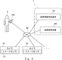
- FIG. 3 is a block diagram of a route information providing system according to a second embodiment.
- FIG. 3 shows a state in which the route information providing system 1, the camera 50 and the user terminal 400 are each communicably connected to the network N1.
- the route information providing system 1 includes a route information providing device 20 and a route search device 300.
- a route information providing system 1 according to the present embodiment is connected to a user terminal 400 owned by a user U and a plurality of cameras 50 so as to be communicable.
- the route information providing system 1 acquires user information from the user terminal 400 possessed by the user U, and acquires image data from the camera 50 .
- the route information providing system 1 presents to the user terminal 400 a route to transportation facilities around the position where the user U exists, based on the acquired user information and image data.
- the route information providing system 1 may include a camera 50 .
- the camera 50 captures the scenery of the place where it is installed, generates image data, and supplies the generated image data to the route information providing system 1 via the network N1.
- Camera 50 includes an image sensor 51 . That is, the camera 50 is an embodiment of a sensor installed on a candidate route for the route information providing system 1 to calculate the degree of crowding of people at the place where the camera 50 is installed.
- Each camera 50 has a unique identifier.
- the camera 50 supplies the image data to the route information providing system 1 in such a manner that the identifier of each camera 50 can be identified.
- the route information providing system 1 can associate each camera 50 with the installation location.
- FIG. 4 is a block diagram of the route information providing device 20 according to the second embodiment.
- the route information providing device 20 differs from the route information providing device 10 according to the first embodiment in that it has an updating unit 116 and a storage unit 120 .
- the update unit 116 causes the congestion degree calculation unit 113 to update the congestion degree of the candidate route in response to a predetermined request signal.
- the predetermined request signal may be, for example, a request signal received from the user terminal 400, or may be set at predetermined intervals (eg, 30 seconds, 60 seconds, or 90 seconds).
- the update unit 116 supplies a signal instructing the congestion degree calculation unit 113 to update the congestion degree.
- the congestion degree calculation unit 113 acquires human data from the sensor installed on the route candidate, calculates the congestion degree, and supplies the calculated congestion degree to the route information generation unit 114 . .
- the route information generator 114 generates route information including the updated congestion degree and supplies the updated route information to the output unit 115 . Furthermore, the output unit 115 outputs the updated route information. Thereby, the route information providing device 20 can suitably present the user U with the degree of congestion of the route candidates.
- the route candidate acquisition unit 112 in the present embodiment is communicably connected to the route search device 300 and acquires information on route candidates from the route search device 300 .
- the route candidate acquisition unit 112 transmits the position information of the user terminal to the route search device and requests route candidates.
- the route candidate acquisition unit 112 acquires the route candidates from the route search device.
- the user information acquired by the user information acquisition unit 111 may include the time tolerance regarding the required time allowed by the user.
- the time tolerance is an index related to the time allowed by the user to reach the boarding place of a predetermined transportation system.
- the route information generation unit 114 generates route information using user information including the time tolerance in addition to the degree of congestion.
- the time tolerance may be a specific time such as 10 minutes or 30 minutes.
- the route information generation unit 114 selects, as a recommended route, a route candidate whose estimated required time is shorter than the time specified as the time tolerance in addition to the degree of congestion.
- the time tolerance may be an abstract and relative identification symbol such as "hurry” or "slowly". For example, when the time tolerance is "hurry", the route information generator 114 selects a route candidate with a short estimated required time as a recommended route. On the other hand, for example, when the time tolerance is "slow", the route information generation unit 114 extracts a plurality of route candidates in order from the route candidate with the shortest estimated required time, and adds the degree of congestion of the extracted plurality of route candidates. to select the recommended route.
- the user information acquired by the user information acquisition unit 111 in the present embodiment may include priority information indicating either the required time priority or the congestion avoidance priority.
- the route information generation unit 114 generates route information using the degree of congestion and priority information included in the user information.
- the route information generating unit 114 when the route information generating unit 114 acquires information indicating priority of required time as priority information, it selects a route candidate with a relatively short required time as a recommended route. Further, when the route information generation unit 114 acquires information indicating congestion avoidance priority as the priority information, the route information generation unit 114 selects a route candidate with a relatively low degree of congestion as a recommended route.
- the congestion degree calculation unit 113 in the present embodiment acquires image data obtained by photographing the scenery of the route candidate from the camera 50 as person data.
- the congestion level calculation unit 113 can, for example, recognize a person image included in this image data, count the number of people present in the captured scenery from the recognized person image, and calculate the congestion level.
- the congestion degree calculation unit 113 may have a trained model trained to derive the congestion degree from the image data, for example, and may calculate the congestion degree by inputting the image data into this trained model.
- the congestion degree calculation unit 113 may also recognize traffic areas such as roads and concourses where people pass, and calculate the congestion degree from the number of people in this traffic area.
- the congestion degree calculation unit 113 may measure the moving speed of a person included in the image data using image data generated at a plurality of different times, and use the measured moving speed to calculate the congestion degree. . That is, for example, the congestion degree calculation unit 113 calculates the degree of congestion when the moving speed of people in an image with a certain number of people X1 is relatively fast, and the congestion degree when the moving speed of people in an image with the same number of people X1 is relatively high. Set it lower than the degree of congestion when it is slow. On the other hand, the congestion degree calculation unit 113 sets the congestion degree when the moving speed of the person is relatively slow to be higher than the congestion degree when the moving speed of the person is relatively fast.
- the congestion degree calculation unit 113 may also measure the distance between persons (inter-person distance) included in the image data, and calculate the congestion degree using the measured inter-person distance. For example, the congestion degree calculation unit 113 measures the distances between the closest persons and calculates the average of these distances. Then, the congestion degree calculation unit 113 uses the calculated average value of the inter-person distances when calculating the congestion degree. For example, when the average value of the inter-person distances in an image in which a certain number of people X1 are present is relatively small, the number of persons in the image is relatively large compared to the case where the average value of inter-person distances in an image in which the number of people X1 is present is relatively large. are densely present. Therefore, in this case, the congestion degree calculation unit 113 sets the congestion degree when the inter-person distance is relatively small higher than the congestion degree when the inter-person distance is relatively large.
- the route information generated by the route information generation unit 114 in this embodiment includes route congestion degree information regarding the degree of congestion of multiple route candidates including the recommended route.
- the route information providing device 20 can suitably present the user U with the congestion situation in the surrounding area.
- the user U using the route information providing system 1 can receive information on a plurality of route candidates including a recommended route and actively select a route. Therefore, the route information providing device 20 can provide highly convenient route information.
- the route information generated by the route information generation unit 114 may include superimposed image data in which map information related to the route candidate and information regarding the degree of congestion of the route are superimposed.
- the route information providing device 20 can provide easy-to-recognize route information. That is, on the user terminal 400, the user U can visually recognize information in which the user's own location, nearby transportation boarding locations, and route candidates including the degree of congestion are superimposed on a map.
- FIG. 5 is a diagram illustrating an example of processing of the congestion degree calculation unit 113 according to the second embodiment.
- the drawing shows a data group input to the congestion degree calculation unit 113 and a data group output from the congestion degree calculation unit 113 .
- the congestion degree calculation unit 113 receives image data generated by the camera 50, position information linked to the camera 50, and the time when the camera 50 captured the image corresponding to the image data as the input data group. and accept. That is, the input data group is person data.
- the congestion degree calculation unit 113 outputs the congestion degree, position information, and time from these input data groups as an output data group.
- the congestion degree calculation unit 113 supplies the output data group to the route information generation unit 114 .
- the congestion degree calculation unit 113 acquires the image data supplied from the camera 50 as the person data, but the person data is not limited to this.
- the person data acquired by the congestion degree calculation unit 113 may include the position data of the portable terminal carried by the person on the candidate route.
- the sensors installed on the route candidates receive position information and unique identifiers transmitted by mobile terminals existing around the sensors. Accordingly, the congestion level calculation unit 113 estimates the number of people present around the sensor, their moving speed, and the like, and calculates the congestion level.
- the person data acquired by the congestion degree calculation unit 113 may include temperature or humidity measurement data on route candidates.
- the sensors installed on the route candidates measure the temperature or humidity in the path along which the person travels, and obtain the temperature or humidity in places around the path. Accordingly, the congestion degree calculation unit 113 measures whether or not the temperature and humidity of the road have risen above the temperature and humidity of the surrounding area, and calculates the degree of congestion from the difference in temperature and humidity.
- the person data acquired by the congestion degree calculation unit 113 may include voice data of voices uttered by people on route candidates.
- the sensors installed on the route candidates collect audio data such as utterances of people passing through the road and footsteps while walking. Accordingly, the congestion level calculation unit 113 calculates the congestion level by measuring the volume of the voice on the road.
- the person data acquired by the congestion degree calculation unit 113 is data regarding the number of posts and the posting frequency of specific text information related to the congestion degree among text information posted on a social network service (SNS) or a predetermined website. may include.
- Person data may include a plurality of the above data.
- FIG. 6 is a block diagram of the route search device 300 according to the second embodiment.
- the route search device 300 uses the user information of the user terminal 400 to search for a route connecting the user terminal 400 and boarding places of transportation facilities in the vicinity thereof, generates route candidates, and provides information about the generated route candidates. It is supplied to the route information providing device 20 .
- the route search device 300 may be a personal computer, a server, an arithmetic processing device for route search, or the like.
- the route search device 300 has a communication section 311, a route search section 312, a control section 313 and a storage section 320 as main components.
- the communication unit 311 is an interface for performing communication between the route searching device 300 and the route information providing device 20. For example, the communication unit 311 receives the location information of the user terminal 400 from the route information providing device 20 via the network N1. The communication unit 311 also transmits information about the route candidates generated via the network N1 to the route information providing device 20 .
- the route search unit 312 searches for one or more routes from the location information of the user terminal 400 to a boarding place of a transportation facility near the user terminal 400, and generates information about route candidates.
- the control unit 313 includes an arithmetic device such as a CPU, and controls each component of the route search device 300 .
- the control unit 414 reads a program from the storage unit 420 and implements a predetermined function according to the read program.
- the storage unit 320 is a storage device including a non-volatile memory, and stores at least a program and map information for causing the route search device 300 to implement the functions of the present embodiment.
- FIG. 7 is a block diagram of the user terminal 400 according to the second embodiment.
- the user terminal 400 may be a mobile phone, smart phone, tablet terminal, or the like.
- the user terminal 400 has a display section 411 , a position information generation section 412 , a communication section 413 , a control section 414 and a storage section 420 as main components.
- the display unit 411 is a display device including, for example, a liquid crystal panel or an organic electroluminescence panel, and displays predetermined information so that the user can see it.
- the display unit 411 displays, for example, route information that the route information providing system 1 outputs to the user terminal 400 .
- the location information generation unit 412 generates information regarding the location of the user terminal 400 .
- the location information generator 412 may acquire location information by GNSS (Global Navigation Satellite System).
- GNSS Global Navigation Satellite System
- the communication unit 413 is an interface for performing communication between the user terminal 400 and the route information providing system 1. For example, the communication unit 413 transmits the location information of the user terminal 400, the identifier of the user terminal 400, and the like to the route information providing system 1 via the network N1. Also, for example, the communication unit 413 receives route information output by the route information providing system 1 .
- the control unit 414 includes an arithmetic device such as a CPU, and controls each component of the user terminal 400 .
- the control unit 414 reads a program from the storage unit 420 and implements a predetermined function according to the read program.
- the storage unit 420 is a storage device including a non-volatile memory, and stores at least a program for causing the user terminal 400 to implement the functions of the present embodiment.
- Such programs may include, for example, an application program for the user terminal 400 to display route information.
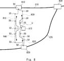
- FIG. 8 is a diagram for showing a specific example of processing performed by the route search device.
- FIG. 8 shows a map of the surroundings of the user U's location.
- User U is located near building A10.
- the building A10 is, for example, a place where many people gather, such as a concert hall or a stadium. After the event ends, the user U is going home from here using a nearby transportation system.
- the first line C10 includes the first station B10.
- the second line C20 includes a second station B20.
- the first line C10 and the second line C20 merge at the third station B30, and continue beyond that point while continuing to merge.
- stations relatively close to the location where the user U is present are the first station B1 and the second station B20.
- a first route R10 and a second route R20 exist as routes connecting the location where the user U exists to the first station. Further, as routes connecting the place where the user U exists to the second station B20, there are a third route R30 and a fourth route R40. A plurality of cameras 50 are installed on the routes of the first route R10, the second route R20, the third route R30 and the fourth route 40. As shown in FIG.
- the user U uses the user terminal 400 to use the route information providing system 1.
- the user U performs an operation requesting the route information providing system 1 to guide the route to the boarding place of the surrounding transportation.
- FIG. 9 is a first diagram showing an example of route information.
- FIG. 9 shows a first image P11 displayed by the display device of the user terminal 400. As shown in FIG. The image P11 is displayed by superimposing an icon U10 representing the user U, a building A10, a first station B10 and a second station B20 on a map of the vicinity of the location where the user U exists.
- the route information providing system 1 generates route information prioritizing required time or route information prioritizing avoidance of congestion according to user U's selection.
- FIG. 10 is a second diagram showing an example of route information.
- FIG. 10 shows the second image P12 displayed by the display device of the user terminal 400. As shown in FIG. The second image P12 shows a state in which the route information providing system 1 generates route information and the user terminal 400 displays the route information after the user U selects "avoid congestion" in the first image P11 shown in FIG. showing.
- the first route R10, the second route R20 and the third route R30 are indicated by dotted lines, and the fourth route R40 is indicated by a thick solid line.
- the locations where the cameras 50 are installed are marked with circular symbols having different diameters.
- the second image P12 also displays messages such as "route found" and "route candidates and recommended routes are displayed”.
- the round symbols shown in the second image P12 indicate the degree of congestion at each location where the camera 50 is installed.
- the diameter of the circle is associated with the degree of congestion. That is, the larger the diameter of the round symbol, the more crowded the location.
- the diameter of the round symbol attached to the fourth route R40 is smaller than that of the other route candidates. That is, the fourth route R40 is less crowded than other route candidates. Therefore, the route information providing system 1 selects the fourth route R40 as the recommended route and displays it with a solid line.
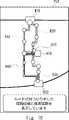
- FIG. 11 is a third diagram showing an example of route information.
- FIG. 11 shows the third image P13 displayed by the display device of the user terminal 400. As shown in FIG. The third image P13 shows a state in which the user U who viewed the second image P12 shown in FIG. 10 selects the fourth route R40 and is proceeding.
- an icon U10 representing the user U is located in the middle of the fourth route R40.
- a route connecting the icon U10 and the second station B20 is indicated by a thick solid line. Route candidates that the user U did not select are indicated by bold white lines.
- the third image P13 displays the message "The latest congestion status is being displayed.”
- the degree of congestion at the place where the camera 50 is installed has changed from the second image P12 shown in FIG. That is, in the route information providing system 1, the updating unit 116 of the route information providing device 20 generates a signal for updating the degree of congestion every 30 seconds, for example. Along with this, the route information generator 114 generates route information including the updated congestion degree. This route information also includes the degree of congestion in route candidates that the user U did not select. With such a configuration, the route information providing system 1 generates information according to changes in circumstances and presents it to the user U. FIG. Therefore, the user U can use route guidance while recognizing updated information.
- the route information providing system 1 is not limited to the configuration described above.
- the user information acquisition unit 111 may further acquire information regarding the destination to which the user is heading.
- the route candidate acquisition unit 112 acquires, as a route candidate, a route for the user to reach the destination using transportation.
- user U requests route guidance for a route to a destination such as home or office.
- the route information providing system 1 guides the route to the destination via transportation.
- the second embodiment has been described above. According to the route information providing system 1 or the route information providing device 20 according to the second embodiment, it is possible to provide a route information providing device, a route information providing method and a program for efficiently using traffic facilities.
- FIG. 12 is a block diagram illustrating the hardware configuration of a computer.
- the route information providing device can realize the functions described above by a computer 500 including the hardware configuration shown in the figure.
- the computer 500 may be a portable computer such as a smart phone or a tablet terminal, or may be a stationary computer such as a PC.
- Computer 500 may be a dedicated computer designed to implement each device, or may be a general-purpose computer.
- the computer 500 can implement desired functions by installing predetermined applications.
- Computer 500 has bus 502 , processor 504 , memory 506 , storage device 508 , input/output interface (I/F) 510 and network interface (I/F) 512 .
- the bus 502 is a data transmission path through which the processor 504, memory 506, storage device 508, input/output interface 510, and network interface 512 exchange data with each other.
- the method of connecting the processors 504 and the like to each other is not limited to bus connection.
- the processor 504 is various processors such as CPU, GPU or FPGA.
- the memory 506 is a main memory implemented using a RAM (Random Access Memory) or the like.
- the storage device 508 is an auxiliary storage device realized using a hard disk, SSD, memory card, ROM (Read Only Memory), or the like.
- the storage device 508 stores programs for realizing desired functions.
- the processor 504 reads this program into the memory 506 and executes it, thereby realizing each functional component of each device.
- the input/output interface 510 is an interface for connecting the computer 500 and input/output devices.
- the input/output interface 510 is connected to an input device such as a keyboard and an output device such as a display device.
- a network interface 512 is an interface for connecting the computer 500 to a network.
- User information acquisition means for acquiring user information including location information of a user terminal owned by a user;
- Route candidate acquisition means for acquiring one or more route candidates connecting the current position of the user terminal and a boarding place of a transportation system in the vicinity of the user terminal based on the position information;
- congestion level calculation means for acquiring person data related to a person existing on the route candidate from a sensor installed on the route candidate, and calculating a congestion level of people on the route candidate from the acquired person data; route information generating means for generating route information regarding a recommended route from the route candidates based on the degree of congestion; and output means for outputting the route information.
- the user information acquired by the user information acquisition means further includes a time tolerance related to the required time allowed by the user, The route information generating means generates the route information based on the user information including the degree of congestion and the time tolerance.
- the route information providing device according to appendix 1. (Appendix 3)
- the user information acquired by the user information acquisition means further includes priority information indicating either the required time priority or the congestion avoidance priority, The route information generating means generates the route information based on the degree of congestion and the user information including the priority information.
- the route information generating means is selecting the route candidate with a relatively short required time as the recommended route when the information indicating the required time priority is acquired as the priority information; selecting the route candidate with the relatively low degree of congestion as the recommended route when the information indicating the congestion avoidance priority is acquired as the priority information;
- the route information providing device according to appendix 3.
- the congestion degree calculation means acquires image data of the scenery of the route candidate as the person data.
- the route information providing device according to any one of Appendices 1 to 4.
- the route information providing apparatus calculates the congestion level based on a moving speed of a person included in the image data.
- the person data acquired by the congestion degree calculation means includes position data of a mobile terminal carried by a person on the route candidate, The route information providing device according to any one of Appendices 1 to 8.
- the person data acquired by the congestion degree calculation means includes measurement data of temperature or humidity in the route candidate, The route information providing device according to any one of Appendices 1 to 9.
- the person data acquired by the congestion degree calculation means includes voice data of a voice uttered by a person on the route candidate, The route information providing device according to any one of Appendices 1 to 10.
- the route information generated by the route information generating means includes route congestion degree information regarding the degree of congestion of the plurality of route candidates including the recommended route, The route information providing device according to any one of Appendices 1 to 11.
- the route information generated by the route information generating means includes superimposed image data obtained by superimposing map information on the route candidate and information on the degree of congestion of the route, The route information providing device according to any one of Appendices 1 to 12.
- (Appendix 14) further comprising updating means for updating the degree of congestion in the candidate route in response to a predetermined request signal;
- the route information generating means generates the route information including the updated congestion degree.
- the route information providing device according to any one of Appendices 1 to 13.
- the user information acquisition means further acquires information regarding a destination to which the user is heading,
- the route candidate acquisition means acquires, as the route candidate, a route for the user to reach the destination using the transportation system.
- the route information providing device according to any one of Appendices 1 to 14.
- the route information providing device according to any one of Appendices 1 to 15; a route search device that searches for a route connecting the user terminal and a boarding place of the transportation system in the vicinity of the user terminal based on the user information and generates the route candidate; Route information system.
- (Appendix 18) obtaining user information including location information of the user terminal and time tolerance of the user; searching for one or more route candidates connecting the current position of the user terminal and a boarding place for transportation in the vicinity of the user terminal based on the position information; Acquiring person data on a plurality of persons from a sensor installed on the route candidate, calculating a degree of congestion of persons on the route candidate from the acquired person data, outputting information about a recommended route selected from the route candidates based on the time tolerance and the congestion degree; A program that causes a computer to execute a route information provision method.
- Non-transitory computer-readable media include various types of tangible storage media.
- non-transitory computer-readable media examples include magnetic recording media (eg, flexible discs, magnetic tapes, hard disk drives), magneto-optical recording media (eg, magneto-optical discs), CD-ROM (Read Only Memory) CD-R, CD - R/W, including semiconductor memory (eg, mask ROM, PROM (Programmable ROM), EPROM (Erasable PROM), flash ROM, RAM (Random Access Memory)).
- the program may also be supplied to the computer on various types of transitory computer readable medium. Examples of transitory computer-readable media include electrical signals, optical signals, and electromagnetic waves. Transitory computer-readable media can deliver the program to the computer via wired channels, such as wires and optical fibers, or wireless channels.
- route information providing system 10 route information providing device 20 route information providing device 50 camera 51 image sensor 111 user information acquisition unit 112 route candidate acquisition unit 113 congestion degree calculation unit 114 route information generation unit 115 output unit 116 update unit 120 storage unit 300 Route search device 311 communication unit 312 route search unit 313 control unit 320 storage unit 400 user terminal 411 display unit 412 position information generation unit 413 communication unit 414 control unit 420 storage unit 500 computer 502 bus 504 processor 506 memory 508 storage device 510 input/output interface 512 network I/F
Abstract
A route information provision device (10) has a user information acquisition unit (111), a route candidate acquisition unit (112), a congestion calculation unit (113), a route information generation unit (114), and an output unit (115). The user information acquisition unit (111) acquires user information including position information for a user terminal that is in the possession of the user. The route candidate acquisition unit (112) acquires information pertaining to at least one candidate route connecting the current position of the user terminal and a boarding location for a transportation facility near the user terminal, on the basis of the position information. The congestion calculation unit (113): acquires pedestrian data about pedestrians present on a candidate route, from a sensor provided on the candidate route; and calculates the amount of pedestrian congestion on the candidate route, from the acquired pedestrian data. The route information generation unit (114) generates route information pertaining to a recommended route among candidate routes, on the basis of the congestion. The output unit (115) outputs the route information.
Description
本発明は経路情報提供装置、経路情報提供システム、経路情報提供方法およびコンピュータ可読媒体に関する。
The present invention relates to a route information providing device, a route information providing system, a route information providing method, and a computer-readable medium.
鉄道やバス等の交通手段を円滑に運用することを目的として、鉄道駅等の交通施設内の混雑を効果的に緩和するための技術が開発されている。
Technologies are being developed to effectively alleviate congestion in transportation facilities such as railway stations, with the aim of smoothly operating means of transportation such as railways and buses.
例えば情報処理システム(特許文献1)は、利用駅候補抽出手段が抽出した利用駅候補の混雑情報を取得し、利用駅候補が混雑する場合は、混雑する利用駅候補に代替可能な代替利用駅を利用する代替経路を取得する。
For example, an information processing system (Patent Literature 1) acquires congestion information of a candidate for use station extracted by a candidate for use station extraction means, and when a candidate for use station is congested, an alternative use station that can be substituted for a candidate for use station that is congested. Get an alternative route using
人流誘導システム(特許文献2)は、路線の運行状況から各駅での乗車可能人数を取得し、各駅で乗車できない人数を滞留必要量として算出し、選択された誘導先滞留エリアへ人を誘導するための誘導情報を配信する。
The people flow guidance system (Patent Document 2) acquires the number of people who can board at each station from the operation status of the route, calculates the number of people who cannot board at each station as the required amount of stay, and guides people to the selected guide destination stay area. Distribute guidance information for
経路探索ツール(特許文献3)は、出発駅、目的駅、ユーザが徒歩移動を許容できる時間を表す徒歩許容時間を含む探索条件を受け付けると経路候補の探索を動的に実行する。その際、途中駅が徒歩移動できる駅で、かつ、その駅に関連付けられている駅間所要時間が徒歩許容時間以下の場合は当該駅と近傍駅とを結ぶ徒歩区間を含めた経路候補の探索を可能とする。経路探索により特定された経路候補に徒歩区間が含まれる場合は、当該駅周辺の地図情報に徒歩区間を明示して出力する。
The route search tool (Patent Document 3) dynamically searches for route candidates when it receives search conditions that include a departure station, a destination station, and an allowable walking time that indicates the time the user is allowed to travel on foot. At that time, if the intermediate station is a station that can be reached on foot and the required time between stations associated with that station is less than the allowable walking time, search for route candidates including the walking section connecting the station and nearby stations. enable If the route candidate specified by the route search includes a walking section, the walking section is specified and output in the map information around the station.
しかしながら、例えば大規模イベントなどが終了した後や、通勤ラッシュなど、大勢が交通施設に向かっているような場合には、交通施設の混雑状況だけでは周囲の状況が把握できない。また交通施設に向かう人が所望の交通施設に到着する前に滞留しなければならない状況は効率的ではない。また駅間の徒歩移動に関して経路案内をする関連技術が存在するが、かかる技術は混雑状況が加味されず、通行経路を選択することができない。
However, for example, after a large-scale event has ended, or when a large number of people are heading to transportation facilities, such as during commuter rush hour, it is not possible to grasp the surrounding situation only by the congestion status of transportation facilities. Also, the situation in which a person heading for a transportation facility must stay before arriving at the desired transportation facility is not efficient. In addition, there is a related technology that provides route guidance for walking between stations, but this technology does not take into account the congestion situation and cannot select a traffic route.
本発明の目的は、上述した課題を鑑み、効率的に交通施設を利用するための経路情報提供装置、経路情報提供方法およびプログラムを提供することにある。
An object of the present invention is to provide a route information providing device, a route information providing method, and a program for efficiently using transportation facilities in view of the above-mentioned problems.
本開示の1実施形態にかかる経路情報提供装置は、ユーザ情報取得部と、経路候補取得部と、混雑度算出部と、経路情報生成部と、出力部と、を有する。ユーザ情報取得部は、ユーザが所持するユーザ端末の位置情報を含むユーザ情報を取得する。経路候補取得部は、位置情報に基づいてユーザ端末の現在位置とユーザ端末の周辺における交通機関の搭乗場所とを結ぶ1以上の経路候補に関する情報を取得する。混雑度算出部は、経路候補に設置されたセンサから経路候補に存在する人物に関する人物データを取得し、取得した人物データから経路候補における人物の混雑度を算出する。経路情報生成部は、混雑度に基づいて経路候補から推奨経路に関する経路情報を生成する。出力部は、経路情報を出力する。
A route information providing device according to an embodiment of the present disclosure includes a user information acquisition unit, a route candidate acquisition unit, a congestion degree calculation unit, a route information generation unit, and an output unit. The user information acquisition unit acquires user information including location information of a user terminal owned by the user. The route candidate acquisition unit acquires information on one or more route candidates connecting the current position of the user terminal and a boarding place of a transportation system in the vicinity of the user terminal based on the position information. The congestion degree calculation unit acquires human data related to a person present on the route candidate from a sensor installed on the route candidate, and calculates the human congestion degree on the route candidate from the acquired human data. The route information generation unit generates route information regarding the recommended route from the route candidates based on the degree of congestion. The output unit outputs route information.
本開示の1実施形態にかかる経路情報提供方法は、以下の方法をコンピュータが実行する。コンピュータは、ユーザが所持するユーザ端末の位置情報を含むユーザ情報を取得する。コンピュータは、位置情報に基づいてユーザ端末の現在位置とユーザ端末の周辺における交通機関の搭乗場所とを結ぶ1以上の経路候補に関する情報を取得する。コンピュータは、経路候補に設置されたセンサから経路候補に存在する人物に関する人物データを取得する。コンピュータは、取得した人物データから経路候補における人物の混雑度を算出する。コンピュータは、混雑度に基づいて経路候補から推奨経路に関する経路情報を生成する。コンピュータは、経路情報を出力する。
A computer executes the following method in a route information providing method according to an embodiment of the present disclosure. The computer acquires user information including location information of a user terminal owned by the user. Based on the position information, the computer obtains information about one or more route candidates connecting the current position of the user terminal and a boarding place for transportation in the vicinity of the user terminal. The computer acquires person data on a person present on the route candidate from the sensor installed on the route candidate. The computer calculates the degree of crowding of people on the candidate route from the acquired human data. A computer generates route information about a recommended route from route candidates based on the degree of congestion. The computer outputs route information.
本開示の1実施形態にかかるプログラムは、コンピュータに、以下のステップを実行させるものである。コンピュータは、ユーザが所持するユーザ端末の位置情報を含むユーザ情報を取得する。コンピュータは、位置情報に基づいてユーザ端末の現在位置とユーザ端末の周辺における交通機関の搭乗場所とを結ぶ1以上の経路候補に関する情報を取得する。コンピュータは、経路候補に設置されたセンサから経路候補に存在する人物に関する人物データを取得する。コンピュータは、取得した人物データから経路候補における人物の混雑度を算出する。コンピュータは、混雑度に基づいて経路候補から推奨経路に関する経路情報を生成する。コンピュータは、経路情報を出力する。
A program according to an embodiment of the present disclosure causes a computer to execute the following steps. The computer acquires user information including location information of a user terminal owned by the user. Based on the position information, the computer obtains information about one or more route candidates connecting the current position of the user terminal and a boarding place for transportation in the vicinity of the user terminal. The computer acquires person data on a person present on the route candidate from the sensor installed on the route candidate. The computer calculates the degree of crowding of people on the candidate route from the acquired human data. A computer generates route information about a recommended route from route candidates based on the degree of congestion. The computer outputs route information.
本開示によれば、効率的に交通施設を利用するための経路情報提供装置、経路情報提供方法およびプログラムを提供することができる。
According to the present disclosure, it is possible to provide a route information providing device, a route information providing method, and a program for efficiently using transportation facilities.
以下、発明の実施の形態を通じて本発明を説明するが、特許請求の範囲にかかる発明を以下の実施形態に限定するものではない。また、実施形態で説明する構成の全てが課題を解決するための手段として必須であるとは限らない。説明の明確化のため、以下の記載および図面は、適宜、省略、および簡略化がなされている。なお、各図面において、同一の要素には同一の符号が付されており、必要に応じて重複説明は省略されている。
The present invention will be described below through embodiments of the invention, but the invention according to the scope of claims is not limited to the following embodiments. Moreover, not all the configurations described in the embodiments are essential as means for solving the problems. For clarity of explanation, the following descriptions and drawings are omitted and simplified as appropriate. In each drawing, the same elements are denoted by the same reference numerals, and redundant description is omitted as necessary.
<実施の形態1>
以下、図面を参照して本発明の実施の形態について説明する。図1は、実施の形態1にかかる経路情報提供装置10のブロック図である。本実施の形態にかかる経路情報提供装置10は、ユーザが所持するユーザ端末と通信可能に接続している。経路情報提供装置10はユーザが存在する位置の周辺の交通機関までの経路をユーザ端末に提示する。経路情報提供装置10は主な構成として、ユーザ情報取得部111、経路候補取得部112、混雑度算出部113、経路情報生成部114および出力部115を有する。 <Embodiment 1>
BEST MODE FOR CARRYING OUT THE INVENTION Hereinafter, embodiments of the present invention will be described with reference to the drawings. FIG. 1 is a block diagram of the routeinformation providing device 10 according to the first embodiment. A route information providing apparatus 10 according to this embodiment is communicably connected to a user terminal owned by a user. The route information providing device 10 presents to the user terminal a route to transportation facilities in the vicinity of the user's location. The route information providing device 10 has a user information acquisition unit 111, a route candidate acquisition unit 112, a congestion degree calculation unit 113, a route information generation unit 114, and an output unit 115 as main components.
以下、図面を参照して本発明の実施の形態について説明する。図1は、実施の形態1にかかる経路情報提供装置10のブロック図である。本実施の形態にかかる経路情報提供装置10は、ユーザが所持するユーザ端末と通信可能に接続している。経路情報提供装置10はユーザが存在する位置の周辺の交通機関までの経路をユーザ端末に提示する。経路情報提供装置10は主な構成として、ユーザ情報取得部111、経路候補取得部112、混雑度算出部113、経路情報生成部114および出力部115を有する。 <
BEST MODE FOR CARRYING OUT THE INVENTION Hereinafter, embodiments of the present invention will be described with reference to the drawings. FIG. 1 is a block diagram of the route
ユーザ情報取得部111は、ユーザ端末からユーザ情報を取得する。ユーザ情報は、ユーザが所持するユーザ端末の位置情報を含む。ユーザ情報は、ユーザ端末の識別子や、経路案内を所望することを示す信号が含まれていてもよい。ユーザ情報取得部111はユーザ情報を取得すると、取得したユーザ情報を経路候補取得部112に供給する。
The user information acquisition unit 111 acquires user information from the user terminal. The user information includes location information of the user terminal owned by the user. The user information may include a user terminal identifier and a signal indicating that route guidance is desired. After acquiring the user information, the user information acquisition unit 111 supplies the acquired user information to the route candidate acquisition unit 112 .
経路候補取得部112は、ユーザ情報に含まれる位置情報から、ユーザ端末の位置とユーザ端末の周辺における交通機関の搭乗場所とを結ぶ1以上の経路候補に関する情報を取得する。交通機関の搭乗場所とは、例えば鉄道の駅やバスの停留所またはタクシー乗り場等である。経路候補に関する情報は、ユーザ端末の存在する位置(現在位置)から交通機関の搭乗場所までを結ぶ通行路と、その通行路を所定の速度で通行した場合に要すると推定される推定所要時間とを含む。所定の速度とは例えば一般的な人間の歩行速度である。所定の速度はユーザ端末ごとに設定されてもよい。
The route candidate acquisition unit 112 acquires, from the position information included in the user information, information about one or more route candidates connecting the position of the user terminal and boarding places of transportation facilities in the vicinity of the user terminal. The boarding place of transportation means, for example, a railway station, a bus stop, a taxi stand, or the like. The information about route candidates includes the route that connects the location of the user terminal (current position) to the boarding location of the transportation system, and the estimated travel time that would be required if the route was traveled at a predetermined speed. including. The predetermined speed is, for example, the normal human walking speed. The predetermined speed may be set for each user terminal.
経路候補取得部112は、地図情報や経路探索プログラムを有していてもよい。この場合、経路候補取得部112は、例えばユーザ端末の緯度及び経度から、かかる緯度及び経度の周辺に位置する交通機関の搭乗場所を検索し、地図情報を利用して搭乗場所までの経路を探索する。
The route candidate acquisition unit 112 may have map information and a route search program. In this case, the route candidate acquisition unit 112, for example, searches for a boarding place of a transportation system located around the latitude and longitude of the user terminal, and searches for a route to the boarding place using map information. do.
経路候補取得部112は、経路情報提供装置10の外部に存在する経路探索装置と通信し、経路探索装置から経路候補を取得してもよい。この場合、経路候補取得部112は、ユーザ端末の位置情報を経路探索装置に送信し、経路候補を要求する。そして経路探索装置が経路候補に関する情報を生成すると、経路候補取得部112は経路探索装置から経路候補を取得する。
The route candidate acquisition unit 112 may communicate with a route search device existing outside the route information providing device 10 and acquire route candidates from the route search device. In this case, the route candidate acquisition unit 112 transmits the position information of the user terminal to the route search device and requests route candidates. When the route search device generates information about route candidates, the route candidate acquisition unit 112 acquires the route candidates from the route search device.
経路候補取得部112は、上述のような方法により経路候補を取得すると、取得した経路候補に関する情報を経路情報生成部114に供給する。
When the route candidate acquisition unit 112 acquires route candidates by the method described above, the route candidate acquisition unit 112 supplies information about the acquired route candidates to the route information generation unit 114 .
混雑度算出部113は、経路候補における人物データを利用して、かかる経路候補における混雑度を算出する。経路候補における人物データは、経路候補に設置されたセンサが取得する。すなわち、経路情報提供装置10は経路候補に設置されたセンサと通信可能に接続している。経路候補における人物データは、経路候補である道路やコンコース等の通行路に存在する人物の混雑度合いを知るためのデータである。
The congestion degree calculation unit 113 uses the person data on the candidate route to calculate the degree of congestion on the candidate route. Human data on the candidate route is acquired by a sensor installed on the candidate route. That is, the route information providing device 10 is communicably connected to the sensors installed on the route candidates. The person data on the candidate route is data for knowing the degree of congestion of people existing on the road, concourse, or other passageway that is the route candidate.
人物データは例えば、経路候補を撮像した画像データである。人物データが画像データを含む場合に、混雑度算出部113は、かかる画像データに含まれる人物の数を測定することにより、その画像データが取得された場所の混雑度を算出できる。混雑度算出部113は、画像データから人物間距離を測定し、人物間距離が比較的に小さい場合に、その場所の混雑度が比較的に高いと算出してもよい。
Person data is, for example, image data obtained by imaging route candidates. When the person data includes image data, the congestion level calculation unit 113 can calculate the congestion level of the place where the image data was obtained by measuring the number of people included in the image data. The congestion degree calculation unit 113 may measure the distance between persons from the image data, and calculate that the degree of congestion at that location is relatively high when the distance between persons is relatively small.
人物データはまた、経路候補における人物がそれぞれ所持する携帯端末の数を示すものであってもよい。この場合例えばセンサは、携帯端末が発信する識別子および位置情報を取得して、所定の経路候補における人物の数を推定可能なデータを生成する。その他、人物データの形式、態様、人物データを生成するセンサの態様等は上述の説明に限定されない。
The person data may also indicate the number of mobile terminals possessed by each person on the route candidate. In this case, for example, the sensor acquires an identifier and location information transmitted by the mobile terminal, and generates data that allows estimation of the number of people on a predetermined route candidate. In addition, the format and aspect of the person data, the aspect of the sensor that generates the person data, and the like are not limited to those described above.
混雑度算出部113が算出する混雑度は、所定の場所における人物の混雑状況を相対的に識別するための指標である。例えば混雑度は0パーセントから100パーセントの数値により示される。この場合、混雑度0パーセントは、センサが設置された場所において人物が検出されない状態を示す。混雑度100パーセントは、センサが設置された場所において人物の密度(例えば単位面積当たりの人数)が所定の閾値を超えた状態であることを示す。混雑度算出部113は、混雑度を算出すると、算出した混雑度を経路情報生成部114に供給する。
The degree of congestion calculated by the degree-of-congestion calculation unit 113 is an index for relatively identifying the state of congestion of people in a predetermined place. For example, the degree of congestion is indicated by a numerical value from 0% to 100%. In this case, a congestion degree of 0% indicates a state in which no person is detected in the place where the sensor is installed. A congestion degree of 100% indicates that the density of people (for example, the number of people per unit area) exceeds a predetermined threshold in the place where the sensor is installed. After calculating the congestion degree, the congestion degree calculation unit 113 supplies the calculated congestion degree to the route information generation unit 114 .
経路情報生成部114は、混雑度算出部113から受け取った混雑度と、経路候補取得部112から受け取った経路候補に関する情報とから、経路情報を生成する。経路情報は、推奨経路に関する情報を含む。
The route information generation unit 114 generates route information from the degree of congestion received from the degree of congestion calculation unit 113 and the information on route candidates received from the route candidate acquisition unit 112 . The route information includes information on recommended routes.
より具体的には、例えば経路情報生成部114は、複数の経路候補のうち、混雑度が低いものを推奨経路として選択し得る。また経路情報生成部114は、複数の経路候補の内、目的地である交通機関の搭乗場所に到達する時間が短い経路を推奨経路として選択し得る。なおこの場合、経路情報生成部114は、経路候補に関する情報に含まれる推定所要時間に対してかかる経路候補の混雑度を加味して、所要時間を修正してもよい。
More specifically, for example, the route information generation unit 114 can select a route with a low degree of congestion from among the plurality of route candidates as a recommended route. In addition, the route information generation unit 114 can select, from among the plurality of route candidates, a route that takes a short time to reach the boarding place of the transportation system, which is the destination, as the recommended route. In this case, the route information generation unit 114 may correct the required time by taking into consideration the degree of congestion of the candidate route to the estimated required time included in the information about the candidate route.
経路情報生成部114がどのように推奨経路を選択するかは、予め設定されていてもよいし、経路情報を生成する際に設定されてもよい。また経路情報は複数の推奨経路を含んでもよいし、複数の推奨経路に順位を付与してもよい。また経路情報は推奨経路として選択しなかった経路候補に関する情報も含んでよい。経路情報生成部114は、経路情報を生成すると、生成した経路情報を、出力部115に供給する。
How the route information generation unit 114 selects the recommended route may be set in advance or may be set when the route information is generated. Also, the route information may include a plurality of recommended routes, and may rank the plurality of recommended routes. The route information may also include information on route candidates that have not been selected as recommended routes. After generating the route information, the route information generation unit 114 supplies the generated route information to the output unit 115 .
出力部115は、経路情報生成部114から経路情報を受け取り、受け取った経路情報を出力する。より具体的には、出力部115は例えば、通信可能に接続しているユーザ端末に、経路情報を送信する。
The output unit 115 receives route information from the route information generation unit 114 and outputs the received route information. More specifically, the output unit 115, for example, transmits route information to user terminals that are communicably connected.
次に、図2を参照して、経路情報提供装置10が行う経路情報提供方法について説明する。図2は、実施の形態1にかかる経路情報提供方法を示すフローチャートである。図2に示すフローチャートは、例えば経路情報提供装置10を起動することにより開始される。
Next, the route information providing method performed by the route information providing device 10 will be described with reference to FIG. FIG. 2 is a flow chart showing the route information providing method according to the first embodiment. The flowchart shown in FIG. 2 is started by starting the route information providing device 10, for example.
まず、ユーザ情報取得部111は、ユーザが所持するユーザ端末の位置情報を含むユーザ情報を取得する(ステップS11)。
First, the user information acquisition unit 111 acquires user information including location information of the user terminal owned by the user (step S11).
次に、経路候補取得部112は、位置情報に基づいてユーザ端末の現在位置とユーザ端末の周辺における交通機関の搭乗場所とを結ぶ1以上の経路候補を取得する(ステップS12)。
Next, the route candidate acquisition unit 112 acquires one or more route candidates connecting the current position of the user terminal and boarding places of transportation facilities in the vicinity of the user terminal based on the position information (step S12).
次に、混雑度算出部113は、経路候補に設置されたセンサから経路候補に存在する人物に関する人物データを取得する(ステップS13)。
Next, the congestion degree calculation unit 113 acquires person data related to a person present on the route candidate from the sensor installed on the route candidate (step S13).
混雑度算出部113は、取得した人物データから経路候補における人物の混雑度を算出する(ステップS14)。
The congestion degree calculation unit 113 calculates the degree of congestion of people on the candidate route from the acquired person data (step S14).
経路情報生成部114は、混雑度に基づいて経路候補から推奨経路に関する経路情報を生成する(ステップS15)。
The route information generation unit 114 generates route information regarding the recommended route from the route candidates based on the degree of congestion (step S15).
出力部115は、経路情報を出力する(ステップS16)。出力部115が経路情報を出力すると、経路情報提供装置10は一連の処理を終了する。
The output unit 115 outputs the route information (step S16). When the output unit 115 outputs the route information, the route information providing device 10 ends the series of processes.
以上、実施の形態1にかかる経路情報提供装置および情報処理方法について説明した。尚、経路情報提供装置10は、図示しない構成としてプロセッサ及び記憶装置を有するものである。経路情報提供装置10が有する記憶装置は、例えばフラッシュメモリやSSD(Solid State Drive)などの不揮発性メモリを含む記憶装置を含む。この場合に、経路情報提供装置10が有する記憶装置は、上述の画像処理方法を実行するためのコンピュータプログラム(以降、単にプログラムとも称する)を記憶している。またプロセッサは、記憶装置からコンピュータプログラムをDRAM(Dynamic Random Access Memory)等のバッファメモリへ読み込ませ、当該プログラムを実行する。
The route information providing device and the information processing method according to the first embodiment have been described above. Note that the route information providing device 10 has a processor and a storage device (not shown). The storage device of the route information providing device 10 includes, for example, a storage device including non-volatile memory such as flash memory and SSD (Solid State Drive). In this case, the storage device of the route information providing device 10 stores a computer program (hereinafter simply referred to as a program) for executing the image processing method described above. The processor also loads a computer program from a storage device into a buffer memory such as a DRAM (Dynamic Random Access Memory) and executes the program.
経路情報提供装置10が有する各構成は、それぞれが専用のハードウェアで実現されていてもよい。また、各構成要素の一部又は全部は、汎用または専用の回路(circuitry)、プロセッサ等やこれらの組合せによって実現されてもよい。これらは、単一のチップによって構成されてもよいし、バスを介して接続される複数のチップによって構成されてもよい。各装置の各構成要素の一部又は全部は、上述した回路等とプログラムとの組合せによって実現されてもよい。また、プロセッサとして、CPU(Central Processing Unit)、GPU(Graphics Processing Unit)、FPGA(field-programmable gate array)等を用いることができる。なお、ここに説明した構成に関する説明は、本開示において以下に説明するその他の装置またはシステムにおいても、適用され得る。
Each configuration of the route information providing device 10 may be realized by dedicated hardware. Also, part or all of each component may be implemented by a general-purpose or dedicated circuit, processor, etc., or a combination thereof. These may be composed of a single chip, or may be composed of multiple chips connected via a bus. A part or all of each component of each device may be implemented by a combination of the above-described circuits and the like and programs. Moreover, CPU (Central Processing Unit), GPU (Graphics Processing Unit), FPGA (field-programmable gate array), etc. can be used as a processor. It should be noted that the configuration descriptions described herein may also be applied to other devices or systems described below in the present disclosure.
また、経路情報提供装置10の各構成要素の一部又は全部が複数の経路情報提供装置や回路等により実現される場合には、複数の経路情報提供装置や回路等は、集中配置されてもよいし、分散配置されてもよい。例えば、経路情報提供装置や回路等は、クライアントサーバシステム、クラウドコンピューティングシステム等、各々が通信ネットワークを介して接続される形態として実現されてもよい。また、経路情報提供装置10の機能がSaaS(Software as a Service)形式で提供されてもよい。
In addition, when part or all of each component of the route information providing device 10 is realized by a plurality of route information providing devices, circuits, etc., the plurality of route information providing devices, circuits, etc. may be centrally arranged. may be distributed. For example, the route information providing device, circuit, etc., may be implemented as a client-server system, a cloud computing system, or the like, each of which is connected via a communication network. Also, the functions of the route information providing device 10 may be provided in a SaaS (Software as a Service) format.
以上、実施の形態1について説明した。実施の形態1によれば、簡易な構成で精度よく混雑度を判定する経路情報提供装置等を提供することができる。
The first embodiment has been described above. According to Embodiment 1, it is possible to provide a route information providing apparatus or the like that accurately determines the degree of congestion with a simple configuration.
<実施の形態2>
次に、実施の形態2について説明する。図3は、実施の形態2にかかる経路情報提供システムのブロック図である。図3は、経路情報提供システム1、カメラ50およびユーザ端末400のそれぞれがネットワークN1に通信可能に接続している状態を示している。 <Embodiment 2>
Next, Embodiment 2 will be described. FIG. 3 is a block diagram of a route information providing system according to a second embodiment. FIG. 3 shows a state in which the routeinformation providing system 1, the camera 50 and the user terminal 400 are each communicably connected to the network N1.
次に、実施の形態2について説明する。図3は、実施の形態2にかかる経路情報提供システムのブロック図である。図3は、経路情報提供システム1、カメラ50およびユーザ端末400のそれぞれがネットワークN1に通信可能に接続している状態を示している。 <Embodiment 2>
Next, Embodiment 2 will be described. FIG. 3 is a block diagram of a route information providing system according to a second embodiment. FIG. 3 shows a state in which the route
経路情報提供システム1は、経路情報提供装置20および経路探索装置300を含む。本実施の形態にかかる経路情報提供システム1は、ユーザUが所持するユーザ端末400および複数のカメラ50と通信可能に接続している。経路情報提供システム1は、ユーザUが所持するユーザ端末400からユーザ情報を取得すると共に、カメラ50から画像データを取得する。経路情報提供システム1は、取得したユーザ情報と、画像データとから、ユーザUが存在する位置の周辺の交通機関までの経路をユーザ端末400に提示する。なお、経路情報提供システム1はカメラ50を含んでもよい。
The route information providing system 1 includes a route information providing device 20 and a route search device 300. A route information providing system 1 according to the present embodiment is connected to a user terminal 400 owned by a user U and a plurality of cameras 50 so as to be communicable. The route information providing system 1 acquires user information from the user terminal 400 possessed by the user U, and acquires image data from the camera 50 . The route information providing system 1 presents to the user terminal 400 a route to transportation facilities around the position where the user U exists, based on the acquired user information and image data. Note that the route information providing system 1 may include a camera 50 .
カメラ50は、設置された場所の風景を撮影して画像データを生成し、生成した画像データを、ネットワークN1を介して経路情報提供システム1に供給する。カメラ50は、イメージセンサ51を含む。すなわちカメラ50は、設置された場所における人物の混雑度を経路情報提供システム1が算出するために経路候補に設置されるセンサの一実施態様である。カメラ50はそれぞれが固有の識別子を有している。カメラ50は、画像データを生成すると、それぞれのカメラ50が有する識別子が識別できる態様により、画像データを経路情報提供システム1に供給する。これにより、経路情報提供システム1は、それぞれのカメラ50と設置場所とを紐づけることができる。
The camera 50 captures the scenery of the place where it is installed, generates image data, and supplies the generated image data to the route information providing system 1 via the network N1. Camera 50 includes an image sensor 51 . That is, the camera 50 is an embodiment of a sensor installed on a candidate route for the route information providing system 1 to calculate the degree of crowding of people at the place where the camera 50 is installed. Each camera 50 has a unique identifier. When the camera 50 generates the image data, the camera 50 supplies the image data to the route information providing system 1 in such a manner that the identifier of each camera 50 can be identified. As a result, the route information providing system 1 can associate each camera 50 with the installation location.
次に、図4を参照して、経路情報提供システム1が含む経路情報提供装置20について説明する。図4は、実施の形態2にかかる経路情報提供装置20のブロック図である。経路情報提供装置20は、更新部116および記憶部120を有する点が、実施の形態1にかかる経路情報提供装置10と異なる。
Next, the route information providing device 20 included in the route information providing system 1 will be described with reference to FIG. FIG. 4 is a block diagram of the route information providing device 20 according to the second embodiment. The route information providing device 20 differs from the route information providing device 10 according to the first embodiment in that it has an updating unit 116 and a storage unit 120 .
更新部116は、所定の要求信号に応じて、混雑度算出部113に経路候補における混雑度を更新させる。所定の要求信号とは、例えばユーザ端末400から受信する要求信号であってもよいし、所定の間隔(例えば30秒、60秒または90秒など)として設定されているものでもよい。更新部116は、上記所定の要求信号を受けると、混雑度算出部113に対して混雑度を更新することを指示する信号を供給する。混雑度算出部113は、更新部116からの指示を受けると、経路候補に設置されたセンサから人物データを取得して混雑度を算出し、算出した混雑度を経路情報生成部114に供給する。この場合、経路情報生成部114は、更新された混雑度を含む経路情報を生成して出力部115に更新した経路情報を供給する。さらに出力部115は更新された経路情報を出力する。これにより経路情報提供装置20は、経路候補の混雑度を好適にユーザUに提示できる。
The update unit 116 causes the congestion degree calculation unit 113 to update the congestion degree of the candidate route in response to a predetermined request signal. The predetermined request signal may be, for example, a request signal received from the user terminal 400, or may be set at predetermined intervals (eg, 30 seconds, 60 seconds, or 90 seconds). Upon receiving the predetermined request signal, the update unit 116 supplies a signal instructing the congestion degree calculation unit 113 to update the congestion degree. Upon receiving an instruction from the update unit 116 , the congestion degree calculation unit 113 acquires human data from the sensor installed on the route candidate, calculates the congestion degree, and supplies the calculated congestion degree to the route information generation unit 114 . . In this case, the route information generator 114 generates route information including the updated congestion degree and supplies the updated route information to the output unit 115 . Furthermore, the output unit 115 outputs the updated route information. Thereby, the route information providing device 20 can suitably present the user U with the degree of congestion of the route candidates.
本実施の形態における経路候補取得部112は、経路探索装置300と通信可能に接続し、経路探索装置300から経路候補に関する情報を取得する。この場合、経路候補取得部112は、ユーザ端末の位置情報を経路探索装置に送信し、経路候補を要求する。そして経路探索装置が経路候補に関する情報を生成すると、経路候補取得部112は経路探索装置から経路候補を取得する。
The route candidate acquisition unit 112 in the present embodiment is communicably connected to the route search device 300 and acquires information on route candidates from the route search device 300 . In this case, the route candidate acquisition unit 112 transmits the position information of the user terminal to the route search device and requests route candidates. When the route search device generates information about route candidates, the route candidate acquisition unit 112 acquires the route candidates from the route search device.
本実施の形態におけるユーザ情報取得部111が取得するユーザ情報は、ユーザが許容する所要時間に関する時間許容度を含んでいてもよい。時間許容度とは、ユーザが所定の交通機関の搭乗場所に到達するまでに許容する時間に関する指標である。この場合、経路情報生成部114は、混雑度に加えて、かかる時間許容度を含むユーザ情報を利用して経路情報を生成する。
The user information acquired by the user information acquisition unit 111 according to the present embodiment may include the time tolerance regarding the required time allowed by the user. The time tolerance is an index related to the time allowed by the user to reach the boarding place of a predetermined transportation system. In this case, the route information generation unit 114 generates route information using user information including the time tolerance in addition to the degree of congestion.
時間許容度は、10分や30分といった具体的な時間であってもよい。この場合、経路情報生成部114は、混雑度に加えて、時間許容度として指定された時間より短い推定所要時間の経路候補を推奨経路として選択する。
The time tolerance may be a specific time such as 10 minutes or 30 minutes. In this case, the route information generation unit 114 selects, as a recommended route, a route candidate whose estimated required time is shorter than the time specified as the time tolerance in addition to the degree of congestion.
また時間許容度は例えば「急いで」や「ゆっくり」などといった抽象的かつ相対的な識別記号であってもよい。例えば時間許容度が「急いで」である場合、経路情報生成部114は、推定所要時間が短い経路候補を推奨経路として選択する。一方、例えば時間許容度が「ゆっくり」である場合、経路情報生成部114は、推定所要時間が最も短い経路候補から順に複数の経路候補を抽出し、抽出した複数の経路候補の混雑度を加味して推奨経路を選択する。
Also, the time tolerance may be an abstract and relative identification symbol such as "hurry" or "slowly". For example, when the time tolerance is "hurry", the route information generator 114 selects a route candidate with a short estimated required time as a recommended route. On the other hand, for example, when the time tolerance is "slow", the route information generation unit 114 extracts a plurality of route candidates in order from the route candidate with the shortest estimated required time, and adds the degree of congestion of the extracted plurality of route candidates. to select the recommended route.
また、本実施の形態におけるユーザ情報取得部111が取得するユーザ情報は、所要時間優先および混雑回避優先のいずれか一方を示す優先情報を含んでもよい。この場合、経路情報生成部114は、混雑度と、ユーザ情報に含まれる優先情報とを利用して経路情報を生成する。
Also, the user information acquired by the user information acquisition unit 111 in the present embodiment may include priority information indicating either the required time priority or the congestion avoidance priority. In this case, the route information generation unit 114 generates route information using the degree of congestion and priority information included in the user information.
またこの場合、経路情報生成部114は、優先情報として所要時間優先を示す情報を取得している場合には、所要時間が比較的に短い経路候補を推奨経路として選択する。また経路情報生成部114は、優先情報として混雑回避優先を示す情報を取得している場合には、混雑度が比較的に低い経路候補を推奨経路として選択する。
In this case, when the route information generating unit 114 acquires information indicating priority of required time as priority information, it selects a route candidate with a relatively short required time as a recommended route. Further, when the route information generation unit 114 acquires information indicating congestion avoidance priority as the priority information, the route information generation unit 114 selects a route candidate with a relatively low degree of congestion as a recommended route.
本実施の形態における混雑度算出部113は、カメラ50から、経路候補の風景を撮影した画像データを人物データとして取得する。混雑度算出部113は、例えばこの画像データに含まれる人物画像を認識し、認識した人物画像から撮影した風景に存在する人物の数をカウントして混雑度を算出し得る。また混雑度算出部113は、例えばこの画像データから混雑度を導出するように学習させた学習済みモデルを有し、この学習済みモデルに画像データを入力することにより混雑度を算出してもよい。混雑度算出部113はまた、人物が通行する道路やコンコースなどの通行領域を認識し、この通行領域内の人数から混雑度を算出してもよい。
The congestion degree calculation unit 113 in the present embodiment acquires image data obtained by photographing the scenery of the route candidate from the camera 50 as person data. The congestion level calculation unit 113 can, for example, recognize a person image included in this image data, count the number of people present in the captured scenery from the recognized person image, and calculate the congestion level. In addition, the congestion degree calculation unit 113 may have a trained model trained to derive the congestion degree from the image data, for example, and may calculate the congestion degree by inputting the image data into this trained model. . The congestion degree calculation unit 113 may also recognize traffic areas such as roads and concourses where people pass, and calculate the congestion degree from the number of people in this traffic area.
また混雑度算出部113は、複数の異なる時刻に生成された画像データを用いて、画像データに含まれる人物の移動速度を測定し、測定した移動速度を混雑度の算出に利用してもよい。すなわち例えば混雑度算出部113は、ある人数X1が存在する画像における人物の移動速度が比較的に速い場合の混雑度を、これと同じ人数X1が存在する画像における人物の移動速度が比較的に遅い場合の混雑度よりも低く設定する。一方、混雑度算出部113は、人物の移動速度が比較的に遅い場合の混雑度を、移動速度が比較的に速い場合の混雑度よりも高く設定する。
In addition, the congestion degree calculation unit 113 may measure the moving speed of a person included in the image data using image data generated at a plurality of different times, and use the measured moving speed to calculate the congestion degree. . That is, for example, the congestion degree calculation unit 113 calculates the degree of congestion when the moving speed of people in an image with a certain number of people X1 is relatively fast, and the congestion degree when the moving speed of people in an image with the same number of people X1 is relatively high. Set it lower than the degree of congestion when it is slow. On the other hand, the congestion degree calculation unit 113 sets the congestion degree when the moving speed of the person is relatively slow to be higher than the congestion degree when the moving speed of the person is relatively fast.
また混雑度算出部113は、画像データに含まれる人物同士の距離(人物間距離)を測定し、測定した人物間距離を利用して混雑度を算出してもよい。例えば混雑度算出部113は、最も近くに存在する人物同士の距離を測定し、これらの平均を算出する。そして混雑度算出部113は、算出した人物間距離の平均値を、混雑度の算出をする際に利用する。例えば、ある人数X1が存在する画像における人物間距離の平均値が比較的に小さい場合には、その人数X1が存在する画像における人物間距離の平均値が比較的に大きい場合に比べて、人物が密集して存在している。よってこの場合に、混雑度算出部113は、人物間距離が比較的に小さい場合の混雑度を、人物間距離が比較的に大きい場合の混雑度よりも高く設定する。
The congestion degree calculation unit 113 may also measure the distance between persons (inter-person distance) included in the image data, and calculate the congestion degree using the measured inter-person distance. For example, the congestion degree calculation unit 113 measures the distances between the closest persons and calculates the average of these distances. Then, the congestion degree calculation unit 113 uses the calculated average value of the inter-person distances when calculating the congestion degree. For example, when the average value of the inter-person distances in an image in which a certain number of people X1 are present is relatively small, the number of persons in the image is relatively large compared to the case where the average value of inter-person distances in an image in which the number of people X1 is present is relatively large. are densely present. Therefore, in this case, the congestion degree calculation unit 113 sets the congestion degree when the inter-person distance is relatively small higher than the congestion degree when the inter-person distance is relatively large.
本実施の形態における経路情報生成部114が生成する経路情報は、推奨経路を含む複数の経路候補の混雑度に関する経路混雑度情報を含む。これにより経路情報提供装置20は、周辺の混雑状況を好適にユーザUに提示できる。また経路情報提供システム1を利用するユーザUは、推奨経路を含む複数の経路候補に関する情報を受け取り、能動的に経路を選択できる。そのため経路情報提供装置20は便宜性の高い経路情報を提供できる。
The route information generated by the route information generation unit 114 in this embodiment includes route congestion degree information regarding the degree of congestion of multiple route candidates including the recommended route. As a result, the route information providing device 20 can suitably present the user U with the congestion situation in the surrounding area. Also, the user U using the route information providing system 1 can receive information on a plurality of route candidates including a recommended route and actively select a route. Therefore, the route information providing device 20 can provide highly convenient route information.
また経路情報生成部114が生成する経路情報は、経路候補にかかる地図情報と、経路の混雑度に関する情報と、が重畳された重畳画像データを含むものであってもよい。これにより経路情報提供装置20は認識容易な経路情報を提供できる。すなわちユーザUは、ユーザ端末400において、自身の存在する場所と、周辺の交通機関の搭乗場所と、混雑度を含む経路候補とが地図に重畳された情報を視認できる。
Further, the route information generated by the route information generation unit 114 may include superimposed image data in which map information related to the route candidate and information regarding the degree of congestion of the route are superimposed. As a result, the route information providing device 20 can provide easy-to-recognize route information. That is, on the user terminal 400, the user U can visually recognize information in which the user's own location, nearby transportation boarding locations, and route candidates including the degree of congestion are superimposed on a map.
次に、図5を参照して混雑度算出部113が行う処理の例を説明する。図5は、実施の形態2にかかる混雑度算出部113の処理の例を示す図である。図は、混雑度算出部113に入力するデータ群と、混雑度算出部113が出力するデータ群とが示されている。図5に示す例において、混雑度算出部113は入力データ群として、カメラ50が生成する画像データと、カメラ50に紐づけされる位置情報と、カメラ50が画像データにかかる画像を撮影した時刻と、を受け付ける。すなわち、入力データ群は、人物データである。混雑度算出部113は、これらの入力データ群から、混雑度と、位置情報と、時刻とを出力データ群として出力する。混雑度算出部113は出力したデータ群を、経路情報生成部114に供給する。
Next, an example of processing performed by the congestion degree calculation unit 113 will be described with reference to FIG. FIG. 5 is a diagram illustrating an example of processing of the congestion degree calculation unit 113 according to the second embodiment. The drawing shows a data group input to the congestion degree calculation unit 113 and a data group output from the congestion degree calculation unit 113 . In the example shown in FIG. 5, the congestion degree calculation unit 113 receives image data generated by the camera 50, position information linked to the camera 50, and the time when the camera 50 captured the image corresponding to the image data as the input data group. and accept. That is, the input data group is person data. The congestion degree calculation unit 113 outputs the congestion degree, position information, and time from these input data groups as an output data group. The congestion degree calculation unit 113 supplies the output data group to the route information generation unit 114 .
なお、図5に示した例では、混雑度算出部113がカメラ50から供給される画像データを人物データとして取得しているが、人物データはこれに限られない。例えば混雑度算出部113が取得する人物データは、経路候補における人物が携帯する携帯端末の位置データを含むものであってもよい。この場合、経路候補に設置されるセンサは、センサの周辺に存在する携帯端末が発信する位置情報および固有識別子を受信する。これにより、混雑度算出部113は、かかるセンサの周辺に存在する人物の数や移動速度等を推定し、混雑度を算出する。
In the example shown in FIG. 5, the congestion degree calculation unit 113 acquires the image data supplied from the camera 50 as the person data, but the person data is not limited to this. For example, the person data acquired by the congestion degree calculation unit 113 may include the position data of the portable terminal carried by the person on the candidate route. In this case, the sensors installed on the route candidates receive position information and unique identifiers transmitted by mobile terminals existing around the sensors. Accordingly, the congestion level calculation unit 113 estimates the number of people present around the sensor, their moving speed, and the like, and calculates the congestion level.
混雑度算出部113が取得する人物データは、経路候補における温度または湿度の計測データを含むものであってもよい。この場合、経路候補に設置されるセンサは、人物の通行路における温度または湿度を計測すると共に、通行路の周辺の場所における温度または湿度を取得する。これにより混雑度算出部113は、通行路の温度や湿度が周辺の温度や湿度よりも上昇したか否かを測定し、温度差や湿度差から混雑度を算出する。
The person data acquired by the congestion degree calculation unit 113 may include temperature or humidity measurement data on route candidates. In this case, the sensors installed on the route candidates measure the temperature or humidity in the path along which the person travels, and obtain the temperature or humidity in places around the path. Accordingly, the congestion degree calculation unit 113 measures whether or not the temperature and humidity of the road have risen above the temperature and humidity of the surrounding area, and calculates the degree of congestion from the difference in temperature and humidity.
混雑度算出部113が取得する人物データは、経路候補における人物が発する音声の音声データを含むものであってもよい。この場合、経路候補に設置されるセンサは、通行路を通行する人物が発する発話や歩行時の足音などの音声データを収集する。これにより混雑度算出部113は通行路の音声の大きさを測定することにより、混雑度を算出する。
The person data acquired by the congestion degree calculation unit 113 may include voice data of voices uttered by people on route candidates. In this case, the sensors installed on the route candidates collect audio data such as utterances of people passing through the road and footsteps while walking. Accordingly, the congestion level calculation unit 113 calculates the congestion level by measuring the volume of the voice on the road.
また混雑度算出部113が取得する人物データは、ソーシャルネットワークサービス(SNS)や所定のウェブサイトに投稿された文字情報のうち、混雑度に関連する特定の文字情報の投稿数や投稿頻度に関するデータを含むものであってもよい。人物データは、上述のデータの複数を含むものであってもよい。
In addition, the person data acquired by the congestion degree calculation unit 113 is data regarding the number of posts and the posting frequency of specific text information related to the congestion degree among text information posted on a social network service (SNS) or a predetermined website. may include. Person data may include a plurality of the above data.
次に、図6を参照して、経路探索装置300について説明する。図6は、実施の形態2にかかる経路探索装置300のブロック図である。経路探索装置300は、ユーザ端末400のユーザ情報を利用して、ユーザ端末400とその周辺における交通機関の搭乗場所とを結ぶ経路を探索して経路候補を生成し、生成した経路候補に関する情報を経路情報提供装置20に供給する。経路探索装置300は、パーソナルコンピュータ、サーバまたは経路探索用の演算処理装置等であってもよい。経路探索装置300は主な構成として、通信部311、経路探索部312、制御部313および記憶部320を有する。
Next, the route search device 300 will be described with reference to FIG. FIG. 6 is a block diagram of the route search device 300 according to the second embodiment. The route search device 300 uses the user information of the user terminal 400 to search for a route connecting the user terminal 400 and boarding places of transportation facilities in the vicinity thereof, generates route candidates, and provides information about the generated route candidates. It is supplied to the route information providing device 20 . The route search device 300 may be a personal computer, a server, an arithmetic processing device for route search, or the like. The route search device 300 has a communication section 311, a route search section 312, a control section 313 and a storage section 320 as main components.
通信部311は、経路探索装置300と経路情報提供装置20との通信を行うためのインタフェースである。例えば、通信部311は、ネットワークN1を介して経路情報提供装置20からユーザ端末400の位置情報を受信する。また通信部311は、ネットワークN1を介して生成した経路候補に関する情報を経路情報提供装置20に送信する。
The communication unit 311 is an interface for performing communication between the route searching device 300 and the route information providing device 20. For example, the communication unit 311 receives the location information of the user terminal 400 from the route information providing device 20 via the network N1. The communication unit 311 also transmits information about the route candidates generated via the network N1 to the route information providing device 20 .
経路探索部312は、ユーザ端末400の位置情報からユーザ端末400の周辺の交通機関の搭乗場所までの1以上の経路を探索し、経路候補に関する情報を生成する。
The route search unit 312 searches for one or more routes from the location information of the user terminal 400 to a boarding place of a transportation facility near the user terminal 400, and generates information about route candidates.
制御部313は、CPU等の演算装置を含み、経路探索装置300の各構成を制御する。制御部414は記憶部420からプログラムを読み取り、読み取ったプログラムにしたがって、本実施形態にかかる所定の機能を実現する。
The control unit 313 includes an arithmetic device such as a CPU, and controls each component of the route search device 300 . The control unit 414 reads a program from the storage unit 420 and implements a predetermined function according to the read program.
記憶部320は、不揮発性メモリを含む記憶装置であって、経路探索装置300に本実施の形態における機能を実現させるためのプログラムおよび地図情報を少なくとも記憶している。
The storage unit 320 is a storage device including a non-volatile memory, and stores at least a program and map information for causing the route search device 300 to implement the functions of the present embodiment.
次に、図7を参照してユーザ端末400について説明する。図7は、実施の形態2にかかるユーザ端末400のブロック図である。ユーザ端末400は、携帯電話、スマートフォンまたはタブレット端末等であってもよい。ユーザ端末400は主な構成として、表示部411、位置情報生成部412、通信部413、制御部414および記憶部420を有している。
Next, the user terminal 400 will be described with reference to FIG. FIG. 7 is a block diagram of the user terminal 400 according to the second embodiment. The user terminal 400 may be a mobile phone, smart phone, tablet terminal, or the like. The user terminal 400 has a display section 411 , a position information generation section 412 , a communication section 413 , a control section 414 and a storage section 420 as main components.
表示部411は、例えば液晶パネルや有機エレクトロルミネッセンスパネルを含む表示装置であって、所定の情報をユーザに視認可能に表示する。表示部411は例えば、経路情報提供システム1がユーザ端末400に対して出力する経路情報を表示する。
The display unit 411 is a display device including, for example, a liquid crystal panel or an organic electroluminescence panel, and displays predetermined information so that the user can see it. The display unit 411 displays, for example, route information that the route information providing system 1 outputs to the user terminal 400 .
位置情報生成部412は、ユーザ端末400の位置に関する情報を生成する。例えば位置情報生成部412はGNSS(Global Navigation Satellite System)による位置情報を取得してもよい。
The location information generation unit 412 generates information regarding the location of the user terminal 400 . For example, the location information generator 412 may acquire location information by GNSS (Global Navigation Satellite System).
通信部413は、ユーザ端末400と経路情報提供システム1との通信を行うためのインタフェースである。例えば、通信部413は、ネットワークN1を介してユーザ端末400の位置情報やユーザ端末400の識別子等を経路情報提供システム1に送信する。また例えば、通信部413は経路情報提供システム1が出力する経路情報を受信する。
The communication unit 413 is an interface for performing communication between the user terminal 400 and the route information providing system 1. For example, the communication unit 413 transmits the location information of the user terminal 400, the identifier of the user terminal 400, and the like to the route information providing system 1 via the network N1. Also, for example, the communication unit 413 receives route information output by the route information providing system 1 .
制御部414は、CPU等の演算装置を含み、ユーザ端末400の各構成を制御する。制御部414は記憶部420からプログラムを読み取り、読み取ったプログラムにしたがって、本実施形態にかかる所定の機能を実現する。
The control unit 414 includes an arithmetic device such as a CPU, and controls each component of the user terminal 400 . The control unit 414 reads a program from the storage unit 420 and implements a predetermined function according to the read program.
記憶部420は不揮発性メモリを含む記憶装置であって、ユーザ端末400に本実施の形態における機能を実現させるためのプログラムを少なくとも記憶している。かかるプログラムは例えば、ユーザ端末400が経路情報を表示するためのアプリケーションプログラムを含み得る。
The storage unit 420 is a storage device including a non-volatile memory, and stores at least a program for causing the user terminal 400 to implement the functions of the present embodiment. Such programs may include, for example, an application program for the user terminal 400 to display route information.
次に、経路情報提供システム1が行う処理を具体例に沿って説明する。図8は、経路探索装置が行う処理の具体例を示すための図である。図8は、ユーザUが存在する場所の周辺の地図を示している。ユーザUは、建物A10の傍に位置している。建物A10は例えば、コンサートホールや競技場など多くの人が集まる場所である。ユーザUはイベントが終了した後に、ここから近くの交通機関を利用して帰宅しようとしている。
Next, the processing performed by the route information providing system 1 will be explained along a specific example. FIG. 8 is a diagram for showing a specific example of processing performed by the route search device. FIG. 8 shows a map of the surroundings of the user U's location. User U is located near building A10. The building A10 is, for example, a place where many people gather, such as a concert hall or a stadium. After the event ends, the user U is going home from here using a nearby transportation system.
ユーザUの周辺には、鉄道の第1路線C10および第2路線C20が示されている。第1路線C10は第1駅B10を含む。第2路線C20は第2駅B20を含む。第1路線C10と第2路線C20とは第3駅B30で合流し、その先は合流したまま伸びている。上述の駅の内、ユーザUが存在する場所から比較的に近い駅は、第1駅B1および第2駅B20である。
Around the user U, a first railway line C10 and a second railway line C20 are shown. The first line C10 includes the first station B10. The second line C20 includes a second station B20. The first line C10 and the second line C20 merge at the third station B30, and continue beyond that point while continuing to merge. Among the stations described above, stations relatively close to the location where the user U is present are the first station B1 and the second station B20.
ユーザUが存在する場所から第1駅までを結ぶ経路としては、第1経路R10および第2経路R20が存在する。またユーザUが存在する場所から第2駅B20までを結ぶ経路としては、第3経路R30および第4経路R40が存在する。第1経路R10、第2経路R20、第3経路R30および第4経路40の経路上には、複数のカメラ50が設置されている。
A first route R10 and a second route R20 exist as routes connecting the location where the user U exists to the first station. Further, as routes connecting the place where the user U exists to the second station B20, there are a third route R30 and a fourth route R40. A plurality of cameras 50 are installed on the routes of the first route R10, the second route R20, the third route R30 and the fourth route 40. As shown in FIG.
このような状況において、ユーザUはユーザ端末400を使い、経路情報提供システム1を利用する。ユーザUは経路情報提供システム1に対して周辺の交通機関の搭乗場所に向かう経路を案内することを要求する操作を行う。
In such a situation, the user U uses the user terminal 400 to use the route information providing system 1. The user U performs an operation requesting the route information providing system 1 to guide the route to the boarding place of the surrounding transportation.
図9は、経路情報の例を示す第1の図である。図9にはユーザ端末400の表示装置が表示する第1画像P11が示されている。画像P11は、ユーザUが存在する場所の周辺の地図に、ユーザUを示すアイコンU10、建物A10、第1駅B10および第2駅B20が重畳されて表示されている。
FIG. 9 is a first diagram showing an example of route information. FIG. 9 shows a first image P11 displayed by the display device of the user terminal 400. As shown in FIG. The image P11 is displayed by superimposing an icon U10 representing the user U, a building A10, a first station B10 and a second station B20 on a map of the vicinity of the location where the user U exists.
また第1画像P11には、「周辺の駅までの経路を探索します」「どちらを優先しますか?」というメッセージとともに「所要時間」と表示されたボタンと、「混雑回避」と表示されたボタンとが表示されている。ユーザUは、経路を探索させるに際し、上述のボタンのどちらかを選択する。経路情報提供システム1は、ユーザUの選択に応じて、所要時間を優先させた経路情報または混雑回避を優先させた経路情報を生成する。
Also, in the first image P11, there are displayed messages such as "We will search for a route to nearby stations" and "Which route do you prefer?" button is displayed. The user U selects one of the above buttons when searching for a route. The route information providing system 1 generates route information prioritizing required time or route information prioritizing avoidance of congestion according to user U's selection.
図10は、経路情報の例を示す第2の図である。図10には、ユーザ端末400の表示装置が表示する第2画像P12が示されている。第2画像P12は、図9に示す第1画像P11においてユーザUが「混雑回避」を選択した後に、経路情報提供システム1が経路情報を生成し、ユーザ端末400が経路情報を表示した状態を示している。
FIG. 10 is a second diagram showing an example of route information. FIG. 10 shows the second image P12 displayed by the display device of the user terminal 400. As shown in FIG. The second image P12 shows a state in which the route information providing system 1 generates route information and the user terminal 400 displays the route information after the user U selects "avoid congestion" in the first image P11 shown in FIG. showing.
図10は、第1経路R10、第2経路R20および第3経路R30が点線により示され、第4経路R40が太い実線により示されている。またそれぞれの経路候補において、カメラ50が設置されている場所には、直径がそれぞれ異なる丸い記号が付されている。また第2画像P12には、「ルートが見つかりました」「経路候補と推奨経路を表示しています」とのメッセージが表示されている。
In FIG. 10, the first route R10, the second route R20 and the third route R30 are indicated by dotted lines, and the fourth route R40 is indicated by a thick solid line. Also, in each route candidate, the locations where the cameras 50 are installed are marked with circular symbols having different diameters. The second image P12 also displays messages such as "route found" and "route candidates and recommended routes are displayed".
上述の状況において、第2画像P12に示されている丸い記号は、カメラ50が設置された場所におけるそれぞれの混雑度を示している。この例の場合、丸の直径は、混雑度の高さに関連付けられている。すなわち、丸い記号は、その直径が大きい程、その場所の混雑度が高いことを示している。第2画面P12によると、第4経路R40に付されている丸い記号の直径は、他の経路候補に比べて小さい。すなわち第4経路R40は他の経路候補に比べて混雑度が低い。よって経路情報提供システム1は推奨経路として第4経路R40を選択し、これを実線により表示している。
In the situation described above, the round symbols shown in the second image P12 indicate the degree of congestion at each location where the camera 50 is installed. In this example, the diameter of the circle is associated with the degree of congestion. That is, the larger the diameter of the round symbol, the more crowded the location. According to the second screen P12, the diameter of the round symbol attached to the fourth route R40 is smaller than that of the other route candidates. That is, the fourth route R40 is less crowded than other route candidates. Therefore, the route information providing system 1 selects the fourth route R40 as the recommended route and displays it with a solid line.
図11は、経路情報の例を示す第3の図である。図11には、ユーザ端末400の表示装置が表示する第3画像P13が示されている。第3画像P13は、図10に示す第2画像P12を見たユーザUが第4経路R40を選択して進行している途中の状態を示している。図11において、ユーザUを示すアイコンU10は第4経路R40の途中に位置している。アイコンU10と第2駅B20とを結ぶ経路は、太い実線により示されている。またユーザUが選択しなかった経路候補は白抜きの太線により示されている。また第3画像P13は、「最新の混雑状況を表示しています」というメッセージが表示されている。
FIG. 11 is a third diagram showing an example of route information. FIG. 11 shows the third image P13 displayed by the display device of the user terminal 400. As shown in FIG. The third image P13 shows a state in which the user U who viewed the second image P12 shown in FIG. 10 selects the fourth route R40 and is proceeding. In FIG. 11, an icon U10 representing the user U is located in the middle of the fourth route R40. A route connecting the icon U10 and the second station B20 is indicated by a thick solid line. Route candidates that the user U did not select are indicated by bold white lines. The third image P13 displays the message "The latest congestion status is being displayed."
図11において、カメラ50が設置された場所における混雑度は、図10に示した第2画像P12から変化している。すなわち経路情報提供システム1において、経路情報提供装置20が有する更新部116は、例えば30秒おきに混雑度を更新する信号を生成する。これに伴い、経路情報生成部114は、更新した混雑度を含む経路情報を生成する。またこの経路情報は、ユーザUが選択しなかった経路候補における混雑度を含む。このような構成により、経路情報提供システム1は、状況の変化に応じた情報を生成し、ユーザUに提示する。よってユーザUは、更新される情報を認識しながら経路案内を利用できる。
In FIG. 11, the degree of congestion at the place where the camera 50 is installed has changed from the second image P12 shown in FIG. That is, in the route information providing system 1, the updating unit 116 of the route information providing device 20 generates a signal for updating the degree of congestion every 30 seconds, for example. Along with this, the route information generator 114 generates route information including the updated congestion degree. This route information also includes the degree of congestion in route candidates that the user U did not select. With such a configuration, the route information providing system 1 generates information according to changes in circumstances and presents it to the user U. FIG. Therefore, the user U can use route guidance while recognizing updated information.
以上、実施の形態について説明した。なお、実施の形態にかかる経路情報提供システム1は上述の構成に限られない。例えば経路情報提供システム1において、ユーザ情報取得部111は、ユーザが向かう目的地に関する情報をさらに取得してもよい。この場合、経路候補取得部112は、ユーザが交通機関を利用して目的地に到達するまでの経路を経路候補として取得する。この場合、例えばユーザUは自宅やオフィスなど、目的地までのルートの経路案内を要求する。経路情報提供システム1はこれに応じて、交通機関を介して目的に到達するまでの経路を案内する。
The embodiment has been described above. Note that the route information providing system 1 according to the embodiment is not limited to the configuration described above. For example, in the route information providing system 1, the user information acquisition unit 111 may further acquire information regarding the destination to which the user is heading. In this case, the route candidate acquisition unit 112 acquires, as a route candidate, a route for the user to reach the destination using transportation. In this case, for example, user U requests route guidance for a route to a destination such as home or office. In response to this, the route information providing system 1 guides the route to the destination via transportation.
以上、実施の形態2について説明した。実施の形態2にかかる経路情報提供システム1または経路情報提供装置20によれば、効率的に交通施設を利用するための経路情報提供装置、経路情報提供方法およびプログラムを提供することができる。
The second embodiment has been described above. According to the route information providing system 1 or the route information providing device 20 according to the second embodiment, it is possible to provide a route information providing device, a route information providing method and a program for efficiently using traffic facilities.
<ハードウェア構成の例>
以下、本開示における情報処理装置の各機能構成がハードウェアとソフトウェアとの組み合わせで実現される場合の例について説明する。 <Example of hardware configuration>
An example in which each functional configuration of the information processing apparatus according to the present disclosure is realized by a combination of hardware and software will be described below.
図12は、コンピュータのハードウェア構成を例示するブロック図である。本開示における経路情報提供装置は、図に示すハードウェア構成を含むコンピュータ500により上述の機能を実現できる。コンピュータ500は、スマートフォンやタブレット端末などといった可搬型のコンピュータであってもよいし、PCなどの据え置き型のコンピュータであってもよい。コンピュータ500は、各装置を実現するために設計された専用のコンピュータであってもよいし、汎用のコンピュータであってもよい。コンピュータ500は、所定のアプリケーションをインストールされることにより、所望の機能を実現できる。
FIG. 12 is a block diagram illustrating the hardware configuration of a computer. The route information providing device according to the present disclosure can realize the functions described above by a computer 500 including the hardware configuration shown in the figure. The computer 500 may be a portable computer such as a smart phone or a tablet terminal, or may be a stationary computer such as a PC. Computer 500 may be a dedicated computer designed to implement each device, or may be a general-purpose computer. The computer 500 can implement desired functions by installing predetermined applications.
コンピュータ500は、バス502、プロセッサ504、メモリ506、ストレージデバイス508、入出力インタフェース(I/F)510およびネットワークインタフェース(I/F)512を有する。バス502は、プロセッサ504、メモリ506、ストレージデバイス508、入出力インタフェース510、及びネットワークインタフェース512が、相互にデータを送受信するためのデータ伝送路である。ただし、プロセッサ504などを互いに接続する方法は、バス接続に限定されない。
Computer 500 has bus 502 , processor 504 , memory 506 , storage device 508 , input/output interface (I/F) 510 and network interface (I/F) 512 . The bus 502 is a data transmission path through which the processor 504, memory 506, storage device 508, input/output interface 510, and network interface 512 exchange data with each other. However, the method of connecting the processors 504 and the like to each other is not limited to bus connection.
プロセッサ504は、CPU、GPUまたはFPGAなどの種々のプロセッサである。メモリ506は、RAM(Random Access Memory)などを用いて実現される主記憶装置である。
The processor 504 is various processors such as CPU, GPU or FPGA. The memory 506 is a main memory implemented using a RAM (Random Access Memory) or the like.
ストレージデバイス508は、ハードディスク、SSD、メモリカード、又はROM(Read Only Memory)などを用いて実現される補助記憶装置である。ストレージデバイス508は、所望の機能を実現するためのプログラムが格納されている。プロセッサ504は、このプログラムをメモリ506に読み出して実行することで、各装置の各機能構成部を実現する。
The storage device 508 is an auxiliary storage device realized using a hard disk, SSD, memory card, ROM (Read Only Memory), or the like. The storage device 508 stores programs for realizing desired functions. The processor 504 reads this program into the memory 506 and executes it, thereby realizing each functional component of each device.
入出力インタフェース510は、コンピュータ500と入出力デバイスとを接続するためのインタフェースである。例えば入出力インタフェース510には、キーボードなどの入力装置や、ディスプレイ装置などの出力装置が接続される。ネットワークインタフェース512は、コンピュータ500をネットワークに接続するためのインタフェースである。
The input/output interface 510 is an interface for connecting the computer 500 and input/output devices. For example, the input/output interface 510 is connected to an input device such as a keyboard and an output device such as a display device. A network interface 512 is an interface for connecting the computer 500 to a network.
以上、本開示における情報処理装置の各機能構成がハードウェアとソフトウェアとの組み合わせで実現される場合の例について説明した。
An example in which each functional configuration of the information processing apparatus according to the present disclosure is realized by a combination of hardware and software has been described above.
なお、本発明は上記実施の形態に限られたものではなく、趣旨を逸脱しない範囲で適宜変更することが可能である。
It should be noted that the present invention is not limited to the above embodiments, and can be modified as appropriate without departing from the scope of the invention.
上記の実施形態の一部又は全部は、以下の付記のようにも記載され得るが、以下には限られない。
(付記1)
ユーザが所持するユーザ端末の位置情報を含むユーザ情報を取得するユーザ情報取得手段と、
前記位置情報に基づいて前記ユーザ端末の現在位置と前記ユーザ端末の周辺における交通機関の搭乗場所とを結ぶ1以上の経路候補を取得する経路候補取得手段と、
前記経路候補に設置されたセンサから前記経路候補に存在する人物に関する人物データを取得し、取得した前記人物データから前記経路候補における人物の混雑度を算出する混雑度算出手段と、
前記混雑度に基づいて前記経路候補から推奨経路に関する経路情報を生成する経路情報生成手段と、
前記経路情報を出力する出力手段と、を備える
経路情報提供装置。
(付記2)
前記ユーザ情報取得手段が取得する前記ユーザ情報は、前記ユーザが許容する所要時間に関する時間許容度をさらに含み、
前記経路情報生成手段は、前記混雑度と前記時間許容度を含む前記ユーザ情報とに基づいて前記経路情報を生成する、
付記1に記載の経路情報提供装置。
(付記3)
前記ユーザ情報取得手段が取得する前記ユーザ情報は、所要時間優先および混雑回避優先のいずれか一方を示す優先情報をさらに含み、
前記経路情報生成手段は、前記混雑度と前記優先情報を含む前記ユーザ情報とに基づいて前記経路情報を生成する、
付記1または2に記載の経路情報提供装置。
(付記4)
前記経路情報生成手段は、
前記優先情報として前記所要時間優先を示す情報を取得している場合には、所要時間が比較的に短い前記経路候補を前記推奨経路として選択し、
前記優先情報として前記混雑回避優先を示す情報を取得している場合には、前記混雑度が比較的に低い前記経路候補を前記推奨経路として選択する、
付記3に記載の経路情報提供装置。
(付記5)
前記混雑度算出手段は、前記経路候補の風景を撮影した画像データを前記人物データとして取得する、
付記1~4のいずれか一項に記載の経路情報提供装置。
(付記6)
前記混雑度算出手段は、前記画像データに含まれる人物の数に基づいて前記混雑度を算出する
付記5に記載の経路情報提供装置。
(付記7)
前記混雑度算出手段は、前記画像データに含まれる人物の移動速度に基づいて前記混雑度を算出する
付記5または6に記載の経路情報提供装置。
(付記8)
前記混雑度算出手段は、前記画像データに含まれる人物間距離に基づいて前記混雑度を算出する
付記5~7のいずれか一項に記載の経路情報提供装置。
(付記9)
前記混雑度算出手段が取得する前記人物データは、前記経路候補における人物が携帯する携帯端末の位置データを含む、
付記1~8のいずれか一項に記載の経路情報提供装置。
(付記10)
前記混雑度算出手段が取得する前記人物データは、前記経路候補における温度または湿度の計測データを含む、
付記1~9のいずれか一項に記載の経路情報提供装置。
(付記11)
前記混雑度算出手段が取得する前記人物データは、前記経路候補における人物が発する音声の音声データを含む、
付記1~10のいずれか一項に記載の経路情報提供装置。
(付記12)
前記経路情報生成手段が生成する前記経路情報は、前記推奨経路を含む複数の前記経路候補の前記混雑度に関する経路混雑度情報を含む、
付記1~11のいずれか一項に記載の経路情報提供装置。
(付記13)
前記経路情報生成手段が生成する前記経路情報は、前記経路候補にかかる地図情報と、前記経路の前記混雑度に関する情報と、が重畳された重畳画像データを含む、
付記1~12のいずれか一項に記載の経路情報提供装置。
(付記14)
所定の要求信号に応じて、前記経路候補における前記混雑度を更新させる更新手段をさらに備え、
前記経路情報生成手段は、更新された前記混雑度を含む前記経路情報を生成する、
付記1~13のいずれか一項に記載の経路情報提供装置。
(付記15)
前記ユーザ情報取得手段は、前記ユーザが向かう目的地に関する情報をさらに取得し、
前記経路候補取得手段は、前記ユーザが前記交通機関を利用して前記目的地に到達するまでの経路を前記経路候補として取得する、
付記1~14のいずれか一項に記載の経路情報提供装置。
(付記16)
付記1~15のいずれか一項に記載の経路情報提供装置と、
前記ユーザ情報に基づいて前記ユーザ端末と前記ユーザ端末の周辺における前記交通機関の搭乗場所とを結ぶ経路を探索して前記経路候補を生成する経路探索装置と、を備える、
経路情報提供システム。
(付記17)
コンピュータが、
ユーザが所持するユーザ端末の位置情報を含むユーザ情報を取得し、
前記位置情報に基づいて前記ユーザ端末の現在位置と前記ユーザ端末の周辺における交通機関の搭乗場所とを結ぶ1以上の経路候補を取得し、
前記経路候補に設置されたセンサから前記経路候補に存在する人物に関する人物データを取得し、
取得した前記人物データから前記経路候補における人物の混雑度を算出し、
前記混雑度に基づいて前記経路候補から推奨経路に関する経路情報を生成し、
前記経路情報を出力する、
経路情報提供方法。
(付記18)
ユーザ端末の位置情報とユーザの時間許容度とを含むユーザ情報を取得し、
前記位置情報に基づいて前記ユーザ端末の現在位置と前記ユーザ端末の周辺における交通機関の乗車場所とを結ぶ1以上の経路候補を探索し、
前記経路候補に設置されたセンサから複数の人物にかかる人物データを取得し、取得した前記人物データから前記経路候補における人物の混雑度を算出し、
前記時間許容度と前記混雑度とに基づいて前記経路候補から選択した推奨経路に関する情報を出力する、
経路情報提供方法をコンピュータに実行させる
プログラム。 Some or all of the above embodiments may also be described in the following additional remarks, but are not limited to the following.
(Appendix 1)
User information acquisition means for acquiring user information including location information of a user terminal owned by a user;
Route candidate acquisition means for acquiring one or more route candidates connecting the current position of the user terminal and a boarding place of a transportation system in the vicinity of the user terminal based on the position information;
congestion level calculation means for acquiring person data related to a person existing on the route candidate from a sensor installed on the route candidate, and calculating a congestion level of people on the route candidate from the acquired person data;
route information generating means for generating route information regarding a recommended route from the route candidates based on the degree of congestion;
and output means for outputting the route information.
(Appendix 2)
The user information acquired by the user information acquisition means further includes a time tolerance related to the required time allowed by the user,
The route information generating means generates the route information based on the user information including the degree of congestion and the time tolerance.
The route information providing device according toappendix 1.
(Appendix 3)
The user information acquired by the user information acquisition means further includes priority information indicating either the required time priority or the congestion avoidance priority,
The route information generating means generates the route information based on the degree of congestion and the user information including the priority information.
The route information providing device according toappendix 1 or 2.
(Appendix 4)
The route information generating means is
selecting the route candidate with a relatively short required time as the recommended route when the information indicating the required time priority is acquired as the priority information;
selecting the route candidate with the relatively low degree of congestion as the recommended route when the information indicating the congestion avoidance priority is acquired as the priority information;
The route information providing device according to appendix 3.
(Appendix 5)
The congestion degree calculation means acquires image data of the scenery of the route candidate as the person data.
The route information providing device according to any one ofAppendices 1 to 4.
(Appendix 6)
6. The route information providing apparatus according to Supplementary note 5, wherein the congestion degree calculation means calculates the congestion degree based on the number of persons included in the image data.
(Appendix 7)
7. The route information providing apparatus according to Supplementary Note 5 or 6, wherein the congestion level calculation means calculates the congestion level based on a moving speed of a person included in the image data.
(Appendix 8)
8. The route information providing apparatus according to any one of Appendices 5 to 7, wherein the congestion degree calculation means calculates the congestion degree based on a distance between persons included in the image data.
(Appendix 9)
The person data acquired by the congestion degree calculation means includes position data of a mobile terminal carried by a person on the route candidate,
The route information providing device according to any one ofAppendices 1 to 8.
(Appendix 10)
The person data acquired by the congestion degree calculation means includes measurement data of temperature or humidity in the route candidate,
The route information providing device according to any one ofAppendices 1 to 9.
(Appendix 11)
The person data acquired by the congestion degree calculation means includes voice data of a voice uttered by a person on the route candidate,
The route information providing device according to any one ofAppendices 1 to 10.
(Appendix 12)
The route information generated by the route information generating means includes route congestion degree information regarding the degree of congestion of the plurality of route candidates including the recommended route,
The route information providing device according to any one ofAppendices 1 to 11.
(Appendix 13)
The route information generated by the route information generating means includes superimposed image data obtained by superimposing map information on the route candidate and information on the degree of congestion of the route,
The route information providing device according to any one ofAppendices 1 to 12.
(Appendix 14)
further comprising updating means for updating the degree of congestion in the candidate route in response to a predetermined request signal;
The route information generating means generates the route information including the updated congestion degree.
The route information providing device according to any one ofAppendices 1 to 13.
(Appendix 15)
The user information acquisition means further acquires information regarding a destination to which the user is heading,
The route candidate acquisition means acquires, as the route candidate, a route for the user to reach the destination using the transportation system.
The route information providing device according to any one ofAppendices 1 to 14.
(Appendix 16)
The route information providing device according to any one ofAppendices 1 to 15;
a route search device that searches for a route connecting the user terminal and a boarding place of the transportation system in the vicinity of the user terminal based on the user information and generates the route candidate;
Route information system.
(Appendix 17)
the computer
Acquiring user information including location information of a user terminal possessed by the user,
Acquiring one or more route candidates connecting the current position of the user terminal and a boarding place for transportation in the vicinity of the user terminal based on the position information;
Acquiring person data related to a person present on the route candidate from a sensor installed on the route candidate;
calculating a congestion degree of people on the route candidate from the acquired person data;
generating route information about a recommended route from the route candidate based on the congestion degree;
outputting the route information;
How to provide route information.
(Appendix 18)
obtaining user information including location information of the user terminal and time tolerance of the user;
searching for one or more route candidates connecting the current position of the user terminal and a boarding place for transportation in the vicinity of the user terminal based on the position information;
Acquiring person data on a plurality of persons from a sensor installed on the route candidate, calculating a degree of congestion of persons on the route candidate from the acquired person data,
outputting information about a recommended route selected from the route candidates based on the time tolerance and the congestion degree;
A program that causes a computer to execute a route information provision method.
(付記1)
ユーザが所持するユーザ端末の位置情報を含むユーザ情報を取得するユーザ情報取得手段と、
前記位置情報に基づいて前記ユーザ端末の現在位置と前記ユーザ端末の周辺における交通機関の搭乗場所とを結ぶ1以上の経路候補を取得する経路候補取得手段と、
前記経路候補に設置されたセンサから前記経路候補に存在する人物に関する人物データを取得し、取得した前記人物データから前記経路候補における人物の混雑度を算出する混雑度算出手段と、
前記混雑度に基づいて前記経路候補から推奨経路に関する経路情報を生成する経路情報生成手段と、
前記経路情報を出力する出力手段と、を備える
経路情報提供装置。
(付記2)
前記ユーザ情報取得手段が取得する前記ユーザ情報は、前記ユーザが許容する所要時間に関する時間許容度をさらに含み、
前記経路情報生成手段は、前記混雑度と前記時間許容度を含む前記ユーザ情報とに基づいて前記経路情報を生成する、
付記1に記載の経路情報提供装置。
(付記3)
前記ユーザ情報取得手段が取得する前記ユーザ情報は、所要時間優先および混雑回避優先のいずれか一方を示す優先情報をさらに含み、
前記経路情報生成手段は、前記混雑度と前記優先情報を含む前記ユーザ情報とに基づいて前記経路情報を生成する、
付記1または2に記載の経路情報提供装置。
(付記4)
前記経路情報生成手段は、
前記優先情報として前記所要時間優先を示す情報を取得している場合には、所要時間が比較的に短い前記経路候補を前記推奨経路として選択し、
前記優先情報として前記混雑回避優先を示す情報を取得している場合には、前記混雑度が比較的に低い前記経路候補を前記推奨経路として選択する、
付記3に記載の経路情報提供装置。
(付記5)
前記混雑度算出手段は、前記経路候補の風景を撮影した画像データを前記人物データとして取得する、
付記1~4のいずれか一項に記載の経路情報提供装置。
(付記6)
前記混雑度算出手段は、前記画像データに含まれる人物の数に基づいて前記混雑度を算出する
付記5に記載の経路情報提供装置。
(付記7)
前記混雑度算出手段は、前記画像データに含まれる人物の移動速度に基づいて前記混雑度を算出する
付記5または6に記載の経路情報提供装置。
(付記8)
前記混雑度算出手段は、前記画像データに含まれる人物間距離に基づいて前記混雑度を算出する
付記5~7のいずれか一項に記載の経路情報提供装置。
(付記9)
前記混雑度算出手段が取得する前記人物データは、前記経路候補における人物が携帯する携帯端末の位置データを含む、
付記1~8のいずれか一項に記載の経路情報提供装置。
(付記10)
前記混雑度算出手段が取得する前記人物データは、前記経路候補における温度または湿度の計測データを含む、
付記1~9のいずれか一項に記載の経路情報提供装置。
(付記11)
前記混雑度算出手段が取得する前記人物データは、前記経路候補における人物が発する音声の音声データを含む、
付記1~10のいずれか一項に記載の経路情報提供装置。
(付記12)
前記経路情報生成手段が生成する前記経路情報は、前記推奨経路を含む複数の前記経路候補の前記混雑度に関する経路混雑度情報を含む、
付記1~11のいずれか一項に記載の経路情報提供装置。
(付記13)
前記経路情報生成手段が生成する前記経路情報は、前記経路候補にかかる地図情報と、前記経路の前記混雑度に関する情報と、が重畳された重畳画像データを含む、
付記1~12のいずれか一項に記載の経路情報提供装置。
(付記14)
所定の要求信号に応じて、前記経路候補における前記混雑度を更新させる更新手段をさらに備え、
前記経路情報生成手段は、更新された前記混雑度を含む前記経路情報を生成する、
付記1~13のいずれか一項に記載の経路情報提供装置。
(付記15)
前記ユーザ情報取得手段は、前記ユーザが向かう目的地に関する情報をさらに取得し、
前記経路候補取得手段は、前記ユーザが前記交通機関を利用して前記目的地に到達するまでの経路を前記経路候補として取得する、
付記1~14のいずれか一項に記載の経路情報提供装置。
(付記16)
付記1~15のいずれか一項に記載の経路情報提供装置と、
前記ユーザ情報に基づいて前記ユーザ端末と前記ユーザ端末の周辺における前記交通機関の搭乗場所とを結ぶ経路を探索して前記経路候補を生成する経路探索装置と、を備える、
経路情報提供システム。
(付記17)
コンピュータが、
ユーザが所持するユーザ端末の位置情報を含むユーザ情報を取得し、
前記位置情報に基づいて前記ユーザ端末の現在位置と前記ユーザ端末の周辺における交通機関の搭乗場所とを結ぶ1以上の経路候補を取得し、
前記経路候補に設置されたセンサから前記経路候補に存在する人物に関する人物データを取得し、
取得した前記人物データから前記経路候補における人物の混雑度を算出し、
前記混雑度に基づいて前記経路候補から推奨経路に関する経路情報を生成し、
前記経路情報を出力する、
経路情報提供方法。
(付記18)
ユーザ端末の位置情報とユーザの時間許容度とを含むユーザ情報を取得し、
前記位置情報に基づいて前記ユーザ端末の現在位置と前記ユーザ端末の周辺における交通機関の乗車場所とを結ぶ1以上の経路候補を探索し、
前記経路候補に設置されたセンサから複数の人物にかかる人物データを取得し、取得した前記人物データから前記経路候補における人物の混雑度を算出し、
前記時間許容度と前記混雑度とに基づいて前記経路候補から選択した推奨経路に関する情報を出力する、
経路情報提供方法をコンピュータに実行させる
プログラム。 Some or all of the above embodiments may also be described in the following additional remarks, but are not limited to the following.
(Appendix 1)
User information acquisition means for acquiring user information including location information of a user terminal owned by a user;
Route candidate acquisition means for acquiring one or more route candidates connecting the current position of the user terminal and a boarding place of a transportation system in the vicinity of the user terminal based on the position information;
congestion level calculation means for acquiring person data related to a person existing on the route candidate from a sensor installed on the route candidate, and calculating a congestion level of people on the route candidate from the acquired person data;
route information generating means for generating route information regarding a recommended route from the route candidates based on the degree of congestion;
and output means for outputting the route information.
(Appendix 2)
The user information acquired by the user information acquisition means further includes a time tolerance related to the required time allowed by the user,
The route information generating means generates the route information based on the user information including the degree of congestion and the time tolerance.
The route information providing device according to
(Appendix 3)
The user information acquired by the user information acquisition means further includes priority information indicating either the required time priority or the congestion avoidance priority,
The route information generating means generates the route information based on the degree of congestion and the user information including the priority information.
The route information providing device according to
(Appendix 4)
The route information generating means is
selecting the route candidate with a relatively short required time as the recommended route when the information indicating the required time priority is acquired as the priority information;
selecting the route candidate with the relatively low degree of congestion as the recommended route when the information indicating the congestion avoidance priority is acquired as the priority information;
The route information providing device according to appendix 3.
(Appendix 5)
The congestion degree calculation means acquires image data of the scenery of the route candidate as the person data.
The route information providing device according to any one of
(Appendix 6)
6. The route information providing apparatus according to Supplementary note 5, wherein the congestion degree calculation means calculates the congestion degree based on the number of persons included in the image data.
(Appendix 7)
7. The route information providing apparatus according to Supplementary Note 5 or 6, wherein the congestion level calculation means calculates the congestion level based on a moving speed of a person included in the image data.
(Appendix 8)
8. The route information providing apparatus according to any one of Appendices 5 to 7, wherein the congestion degree calculation means calculates the congestion degree based on a distance between persons included in the image data.
(Appendix 9)
The person data acquired by the congestion degree calculation means includes position data of a mobile terminal carried by a person on the route candidate,
The route information providing device according to any one of
(Appendix 10)
The person data acquired by the congestion degree calculation means includes measurement data of temperature or humidity in the route candidate,
The route information providing device according to any one of
(Appendix 11)
The person data acquired by the congestion degree calculation means includes voice data of a voice uttered by a person on the route candidate,
The route information providing device according to any one of
(Appendix 12)
The route information generated by the route information generating means includes route congestion degree information regarding the degree of congestion of the plurality of route candidates including the recommended route,
The route information providing device according to any one of
(Appendix 13)
The route information generated by the route information generating means includes superimposed image data obtained by superimposing map information on the route candidate and information on the degree of congestion of the route,
The route information providing device according to any one of
(Appendix 14)
further comprising updating means for updating the degree of congestion in the candidate route in response to a predetermined request signal;
The route information generating means generates the route information including the updated congestion degree.
The route information providing device according to any one of
(Appendix 15)
The user information acquisition means further acquires information regarding a destination to which the user is heading,
The route candidate acquisition means acquires, as the route candidate, a route for the user to reach the destination using the transportation system.
The route information providing device according to any one of
(Appendix 16)
The route information providing device according to any one of
a route search device that searches for a route connecting the user terminal and a boarding place of the transportation system in the vicinity of the user terminal based on the user information and generates the route candidate;
Route information system.
(Appendix 17)
the computer
Acquiring user information including location information of a user terminal possessed by the user,
Acquiring one or more route candidates connecting the current position of the user terminal and a boarding place for transportation in the vicinity of the user terminal based on the position information;
Acquiring person data related to a person present on the route candidate from a sensor installed on the route candidate;
calculating a congestion degree of people on the route candidate from the acquired person data;
generating route information about a recommended route from the route candidate based on the congestion degree;
outputting the route information;
How to provide route information.
(Appendix 18)
obtaining user information including location information of the user terminal and time tolerance of the user;
searching for one or more route candidates connecting the current position of the user terminal and a boarding place for transportation in the vicinity of the user terminal based on the position information;
Acquiring person data on a plurality of persons from a sensor installed on the route candidate, calculating a degree of congestion of persons on the route candidate from the acquired person data,
outputting information about a recommended route selected from the route candidates based on the time tolerance and the congestion degree;
A program that causes a computer to execute a route information provision method.
上述の実施の形態では、本発明をハードウェアの構成として説明したが、本発明は、これに限定されるものではない。本発明は、任意の処理を、CPU(Central Processing Unit)にコンピュータプログラムを実行させることにより実現することも可能である。 また、上述したプログラムは、様々なタイプの非一時的なコンピュータ可読媒体(non-transitory computer readable medium)を用いて格納され、コンピュータに供給することができる。非一時的なコンピュータ可読媒体は、様々なタイプの実体のある記録媒体(tangible storage medium)を含む。非一時的なコンピュータ可読媒体の例は、磁気記録媒体(例えばフレキシブルディスク、磁気テープ、ハードディスクドライブ)、光磁気記録媒体(例えば光磁気ディスク)、CD-ROM(Read Only Memory)CD-R、CD-R/W、半導体メモリ(例えば、マスクROM、PROM(Programmable ROM)、EPROM(Erasable PROM)、フラッシュROM、RAM(Random Access Memory))を含む。また、プログラムは、様々なタイプの一時的なコンピュータ可読媒体(transitory computer readable medium)によってコンピュータに供給されてもよい。一時的なコンピュータ可読媒体の例は、電気信号、光信号、及び電磁波を含む。一時的なコンピュータ可読媒体は、電線及び光ファイバ等の有線通信路、又は無線通信路を介して、プログラムをコンピュータに供給できる。
Although the present invention has been described as a hardware configuration in the above embodiment, the present invention is not limited to this. The present invention can also implement arbitrary processing by causing a CPU (Central Processing Unit) to execute a computer program. Also, the above-described program can be stored and supplied to a computer using various types of non-transitory computer readable media. Non-transitory computer-readable media include various types of tangible storage media. Examples of non-transitory computer-readable media include magnetic recording media (eg, flexible discs, magnetic tapes, hard disk drives), magneto-optical recording media (eg, magneto-optical discs), CD-ROM (Read Only Memory) CD-R, CD - R/W, including semiconductor memory (eg, mask ROM, PROM (Programmable ROM), EPROM (Erasable PROM), flash ROM, RAM (Random Access Memory)). The program may also be supplied to the computer on various types of transitory computer readable medium. Examples of transitory computer-readable media include electrical signals, optical signals, and electromagnetic waves. Transitory computer-readable media can deliver the program to the computer via wired channels, such as wires and optical fibers, or wireless channels.
この出願は、2021年3月23日に出願された日本出願特願2021-049221を基礎とする優先権を主張し、その開示の全てをここに取り込む。
This application claims priority based on Japanese Patent Application No. 2021-049221 filed on March 23, 2021, and the entire disclosure thereof is incorporated herein.
1 経路情報提供システム
10 経路情報提供装置
20 経路情報提供装置
50 カメラ
51 イメージセンサ
111 ユーザ情報取得部
112 経路候補取得部
113 混雑度算出部
114 経路情報生成部
115 出力部
116 更新部
120 記憶部
300 経路探索装置
311 通信部
312 経路探索部
313 制御部
320 記憶部
400 ユーザ端末
411 表示部
412 位置情報生成部
413 通信部
414 制御部
420 記憶部
500 コンピュータ
502 バス
504 プロセッサ
506 メモリ
508 ストレージデバイス
510 出入力I/F
512 ネットワークI/F 1 routeinformation providing system 10 route information providing device 20 route information providing device 50 camera 51 image sensor 111 user information acquisition unit 112 route candidate acquisition unit 113 congestion degree calculation unit 114 route information generation unit 115 output unit 116 update unit 120 storage unit 300 Route search device 311 communication unit 312 route search unit 313 control unit 320 storage unit 400 user terminal 411 display unit 412 position information generation unit 413 communication unit 414 control unit 420 storage unit 500 computer 502 bus 504 processor 506 memory 508 storage device 510 input/output interface
512 network I/F
10 経路情報提供装置
20 経路情報提供装置
50 カメラ
51 イメージセンサ
111 ユーザ情報取得部
112 経路候補取得部
113 混雑度算出部
114 経路情報生成部
115 出力部
116 更新部
120 記憶部
300 経路探索装置
311 通信部
312 経路探索部
313 制御部
320 記憶部
400 ユーザ端末
411 表示部
412 位置情報生成部
413 通信部
414 制御部
420 記憶部
500 コンピュータ
502 バス
504 プロセッサ
506 メモリ
508 ストレージデバイス
510 出入力I/F
512 ネットワークI/F 1 route
512 network I/F
Claims (18)
- ユーザが所持するユーザ端末の位置情報を含むユーザ情報を取得するユーザ情報取得手段と、
前記位置情報に基づいて前記ユーザ端末の現在位置と前記ユーザ端末の周辺における交通機関の搭乗場所とを結ぶ1以上の経路候補に関する情報を取得する経路候補取得手段と、
前記経路候補に設置されたセンサから前記経路候補に存在する人物に関する人物データを取得し、取得した前記人物データから前記経路候補における人物の混雑度を算出する混雑度算出手段と、
前記混雑度に基づいて前記経路候補から推奨経路に関する経路情報を生成する経路情報生成手段と、
前記経路情報を出力する出力手段と、を備える
経路情報提供装置。 User information acquisition means for acquiring user information including location information of a user terminal owned by a user;
route candidate acquisition means for acquiring information on one or more route candidates connecting the current position of the user terminal and a boarding place of a transportation system in the vicinity of the user terminal based on the position information;
congestion level calculation means for acquiring person data related to a person existing on the route candidate from a sensor installed on the route candidate, and calculating a congestion level of people on the route candidate from the acquired person data;
route information generating means for generating route information regarding a recommended route from the route candidates based on the degree of congestion;
and output means for outputting the route information. - 前記ユーザ情報取得手段が取得する前記ユーザ情報は、前記ユーザが許容する所要時間に関する時間許容度をさらに含み、
前記経路情報生成手段は、前記混雑度と前記時間許容度を含む前記ユーザ情報とに基づいて前記経路情報を生成する、
請求項1に記載の経路情報提供装置。 The user information acquired by the user information acquisition means further includes a time tolerance related to the required time allowed by the user,
The route information generating means generates the route information based on the user information including the degree of congestion and the time tolerance.
The route information providing device according to claim 1. - 前記ユーザ情報取得手段が取得する前記ユーザ情報は、所要時間優先および混雑回避優先のいずれか一方を示す優先情報をさらに含み、
前記経路情報生成手段は、前記混雑度と前記優先情報を含む前記ユーザ情報とに基づいて前記経路情報を生成する、
請求項1または2に記載の経路情報提供装置。 The user information acquired by the user information acquisition means further includes priority information indicating either the required time priority or the congestion avoidance priority,
The route information generating means generates the route information based on the degree of congestion and the user information including the priority information.
3. The route information providing device according to claim 1 or 2. - 前記経路情報生成手段は、
前記優先情報として前記所要時間優先を示す情報を取得している場合には、所要時間が比較的に短い前記経路候補を前記推奨経路として選択し、
前記優先情報として前記混雑回避優先を示す情報を取得している場合には、前記混雑度が比較的に低い前記経路候補を前記推奨経路として選択する、
請求項3に記載の経路情報提供装置。 The route information generating means is
selecting the route candidate with a relatively short required time as the recommended route when the information indicating the required time priority is acquired as the priority information;
selecting the route candidate with the relatively low degree of congestion as the recommended route when the information indicating the congestion avoidance priority is acquired as the priority information;
4. The route information providing device according to claim 3. - 前記混雑度算出手段は、前記経路候補の風景を撮影した画像データを前記人物データとして取得する、
請求項1~4のいずれか一項に記載の経路情報提供装置。 The congestion degree calculation means acquires image data of the scenery of the route candidate as the person data.
A route information providing device according to any one of claims 1 to 4. - 前記混雑度算出手段は、前記画像データに含まれる人物の数に基づいて前記混雑度を算出する
請求項5に記載の経路情報提供装置。 6. The route information providing apparatus according to claim 5, wherein said congestion degree calculation means calculates said congestion degree based on the number of persons included in said image data. - 前記混雑度算出手段は、前記画像データに含まれる人物の移動速度に基づいて前記混雑度を算出する
請求項5または6に記載の経路情報提供装置。 7. The route information providing apparatus according to claim 5, wherein said congestion degree calculating means calculates said congestion degree based on a moving speed of a person included in said image data. - 前記混雑度算出手段は、前記画像データに含まれる人物間距離に基づいて前記混雑度を算出する
請求項5~7のいずれか一項に記載の経路情報提供装置。 8. The route information providing apparatus according to any one of claims 5 to 7, wherein said congestion degree calculating means calculates said congestion degree based on a distance between persons included in said image data. - 前記混雑度算出手段が取得する前記人物データは、前記経路候補における人物が携帯する携帯端末の位置データを含む、
請求項1~8のいずれか一項に記載の経路情報提供装置。 The person data acquired by the congestion degree calculation means includes position data of a mobile terminal carried by a person on the route candidate,
A route information providing device according to any one of claims 1 to 8. - 前記混雑度算出手段が取得する前記人物データは、前記経路候補における温度または湿度の計測データを含む、
請求項1~9のいずれか一項に記載の経路情報提供装置。 The person data acquired by the congestion degree calculation means includes measurement data of temperature or humidity in the route candidate,
A route information providing device according to any one of claims 1 to 9. - 前記混雑度算出手段が取得する前記人物データは、前記経路候補における人物が発する音声の音声データを含む、
請求項1~10のいずれか一項に記載の経路情報提供装置。 The person data acquired by the congestion degree calculation means includes voice data of a voice uttered by a person on the route candidate,
A route information providing device according to any one of claims 1 to 10. - 前記経路情報生成手段が生成する前記経路情報は、前記推奨経路を含む複数の前記経路候補の前記混雑度に関する経路混雑度情報を含む、
請求項1~11のいずれか一項に記載の経路情報提供装置。 The route information generated by the route information generating means includes route congestion degree information regarding the degree of congestion of the plurality of route candidates including the recommended route,
A route information providing device according to any one of claims 1 to 11. - 前記経路情報生成手段が生成する前記経路情報は、前記経路候補にかかる地図情報と、前記経路の前記混雑度に関する情報と、が重畳された重畳画像データを含む、
請求項1~12のいずれか一項に記載の経路情報提供装置。 The route information generated by the route information generating means includes superimposed image data obtained by superimposing map information on the route candidate and information on the degree of congestion of the route,
A route information providing device according to any one of claims 1 to 12. - 所定の要求信号に応じて、前記経路候補における前記混雑度を更新させる更新手段をさらに備え、
前記経路情報生成手段は、更新された前記混雑度を含む前記経路情報を生成する、
請求項1~13のいずれか一項に記載の経路情報提供装置。 further comprising updating means for updating the degree of congestion in the candidate route in response to a predetermined request signal;
The route information generating means generates the route information including the updated congestion degree.
A route information providing device according to any one of claims 1 to 13. - 前記ユーザ情報取得手段は、前記ユーザが向かう目的地に関する情報をさらに取得し、
前記経路候補取得手段は、前記ユーザが前記交通機関を利用して前記目的地に到達するまでの経路を前記経路候補として取得する、
請求項1~14のいずれか一項に記載の経路情報提供装置。 The user information acquisition means further acquires information regarding a destination to which the user is heading,
The route candidate acquisition means acquires, as the route candidate, a route for the user to reach the destination using the transportation system.
A route information providing device according to any one of claims 1 to 14. - 請求項1~15のいずれか一項に記載の経路情報提供装置と、
前記ユーザ情報に基づいて前記ユーザ端末と前記ユーザ端末の周辺における前記交通機関の搭乗場所とを結ぶ経路を探索して前記経路候補を生成する経路探索装置と、を備える、
経路情報提供システム。 A route information providing device according to any one of claims 1 to 15;
a route search device that searches for a route connecting the user terminal and a boarding place of the transportation system in the vicinity of the user terminal based on the user information and generates the route candidate;
Route information system. - コンピュータが、
ユーザが所持するユーザ端末の位置情報を含むユーザ情報を取得し、
前記位置情報に基づいて前記ユーザ端末の現在位置と前記ユーザ端末の周辺における交通機関の搭乗場所とを結ぶ1以上の経路候補に関する情報を取得し、
前記経路候補に設置されたセンサから前記経路候補に存在する人物に関する人物データを取得し、
取得した前記人物データから前記経路候補における人物の混雑度を算出し、
前記混雑度に基づいて前記経路候補から推奨経路に関する経路情報を生成し、
前記経路情報を出力する、
経路情報提供方法。 the computer
Acquiring user information including location information of a user terminal possessed by the user,
Acquiring information about one or more route candidates connecting the current position of the user terminal and a boarding place for transportation in the vicinity of the user terminal based on the position information;
Acquiring person data related to a person present on the route candidate from a sensor installed on the route candidate;
calculating a congestion degree of people on the route candidate from the acquired person data;
generating route information about a recommended route from the route candidate based on the congestion degree;
outputting the route information;
How to provide route information. - ユーザ端末の位置情報とユーザの時間許容度とを含むユーザ情報を取得し、
前記位置情報に基づいて前記ユーザ端末の現在位置と前記ユーザ端末の周辺における交通機関の乗車場所とを結ぶ1以上の経路候補に関する情報を探索し、
前記経路候補に設置されたセンサから複数の人物にかかる人物データを取得し、取得した前記人物データから前記経路候補における人物の混雑度を算出し、
前記時間許容度と前記混雑度とに基づいて前記経路候補から選択した推奨経路に関する情報を出力する、
経路情報提供方法をコンピュータに実行させる
プログラムが格納された非一時的なコンピュータ可読媒体。 obtaining user information including location information of the user terminal and time tolerance of the user;
Searching for information on one or more route candidates connecting the current position of the user terminal and a boarding place for transportation in the vicinity of the user terminal based on the position information;
Acquiring person data on a plurality of persons from a sensor installed on the route candidate, calculating a degree of congestion of persons on the route candidate from the acquired person data,
outputting information about a recommended route selected from the route candidates based on the time tolerance and the congestion degree;
A non-transitory computer-readable medium storing a program for causing a computer to execute a route information providing method.
Priority Applications (1)
| Application Number | Priority Date | Filing Date | Title |
|---|---|---|---|
| JP2023508674A JPWO2022201779A5 (en) | 2022-01-17 | Route information providing device, route information providing method and program |
Applications Claiming Priority (2)
| Application Number | Priority Date | Filing Date | Title |
|---|---|---|---|
| JP2021-049221 | 2021-03-23 | ||
| JP2021049221 | 2021-03-23 |
Publications (1)
| Publication Number | Publication Date |
|---|---|
| WO2022201779A1 true WO2022201779A1 (en) | 2022-09-29 |
Family
ID=83396796
Family Applications (1)
| Application Number | Title | Priority Date | Filing Date |
|---|---|---|---|
| PCT/JP2022/001406 WO2022201779A1 (en) | 2021-03-23 | 2022-01-17 | Route information provision device, route information provision system, route information provision method, and computer-readable medium |
Country Status (1)
| Country | Link |
|---|---|
| WO (1) | WO2022201779A1 (en) |
Citations (9)
| Publication number | Priority date | Publication date | Assignee | Title |
|---|---|---|---|---|
| JPH06201389A (en) * | 1993-01-05 | 1994-07-19 | Fujitsu Ten Ltd | Route searching device |
| JP2002189827A (en) * | 2000-12-20 | 2002-07-05 | Fuji Xerox Co Ltd | Area information providing system |
| JP2004257829A (en) * | 2003-02-25 | 2004-09-16 | Denso Corp | Navigation system for vehicle |
| JP2006047274A (en) * | 2004-07-07 | 2006-02-16 | East Japan Railway Co | Route guidance system |
| WO2009054119A1 (en) * | 2007-10-26 | 2009-04-30 | Panasonic Corporation | Situation judging device, situation judging method, situation judging program, abnormality judging device, abnormality judging method, abnormality judging program, and congestion estimating device |
| JP2009162702A (en) * | 2008-01-10 | 2009-07-23 | Sharp Corp | Navigation system, navigation server, and cellular phone |
| JP2009271023A (en) * | 2008-05-12 | 2009-11-19 | Nec Corp | Route searching apparatus |
| JP2019036304A (en) * | 2017-08-18 | 2019-03-07 | 能美防災株式会社 | Disaster prevention system |
| JP2019179045A (en) * | 2019-07-25 | 2019-10-17 | アイシン・エィ・ダブリュ株式会社 | Route search system, route search method and computer program |
-
2022
- 2022-01-17 WO PCT/JP2022/001406 patent/WO2022201779A1/en active Application Filing
Patent Citations (9)
| Publication number | Priority date | Publication date | Assignee | Title |
|---|---|---|---|---|
| JPH06201389A (en) * | 1993-01-05 | 1994-07-19 | Fujitsu Ten Ltd | Route searching device |
| JP2002189827A (en) * | 2000-12-20 | 2002-07-05 | Fuji Xerox Co Ltd | Area information providing system |
| JP2004257829A (en) * | 2003-02-25 | 2004-09-16 | Denso Corp | Navigation system for vehicle |
| JP2006047274A (en) * | 2004-07-07 | 2006-02-16 | East Japan Railway Co | Route guidance system |
| WO2009054119A1 (en) * | 2007-10-26 | 2009-04-30 | Panasonic Corporation | Situation judging device, situation judging method, situation judging program, abnormality judging device, abnormality judging method, abnormality judging program, and congestion estimating device |
| JP2009162702A (en) * | 2008-01-10 | 2009-07-23 | Sharp Corp | Navigation system, navigation server, and cellular phone |
| JP2009271023A (en) * | 2008-05-12 | 2009-11-19 | Nec Corp | Route searching apparatus |
| JP2019036304A (en) * | 2017-08-18 | 2019-03-07 | 能美防災株式会社 | Disaster prevention system |
| JP2019179045A (en) * | 2019-07-25 | 2019-10-17 | アイシン・エィ・ダブリュ株式会社 | Route search system, route search method and computer program |
Also Published As
| Publication number | Publication date |
|---|---|
| JPWO2022201779A1 (en) | 2022-09-29 |
Similar Documents
| Publication | Publication Date | Title |
|---|---|---|
| JP5243896B2 (en) | Information display system, information display method, and computer program | |
| JP2007066106A (en) | Route guiding apparatus | |
| JP5238422B2 (en) | Information provision system | |
| KR101886966B1 (en) | Method for providing customized travel plan and server implementing the same | |
| CN113160607B (en) | Parking space navigation method and device, electronic equipment, storage medium and product | |
| JP6470010B2 (en) | Information processing system, information processing program, information processing apparatus, and information processing method | |
| KR101280313B1 (en) | Smart bus information system | |
| JP2019020172A (en) | Route proposing device and route proposition method | |
| JP7433380B2 (en) | Route evaluation device, route evaluation method, and route evaluation program | |
| CN110542427A (en) | Information processing apparatus, information processing method, and information processing system | |
| JP2008152364A (en) | Information providing device, information providing method, information providing program and computer-readable recording medium | |
| WO2022201779A1 (en) | Route information provision device, route information provision system, route information provision method, and computer-readable medium | |
| Kishore et al. | CENSE: A cognitive navigation system for people with special needs | |
| US11181381B2 (en) | Portable pedestrian navigation system | |
| JP5053135B2 (en) | Traffic information display system, traffic information display server, traffic information display method, and computer program | |
| WO2015114955A1 (en) | Information providing system and method | |
| JP5956120B2 (en) | Information processing system, information processing apparatus, information processing program, and information processing method | |
| JP2019074780A (en) | Information processing device, information processing method, information processing system, and program | |
| JP6658748B2 (en) | Route management system, route management method, and computer-readable recording medium | |
| JPWO2016052237A1 (en) | Information processing apparatus, control method thereof, and program | |
| JP6419603B2 (en) | Information processing device, position display system | |
| US20220163345A1 (en) | Information processing apparatus, information processing method, and non-transitory storage medium | |
| US20220049964A1 (en) | Server apparatus, information processing system, medium, and method of operating information processing system | |
| KR20100071793A (en) | Server for providing route service, terminal and method for providing route service | |
| WO2022201722A1 (en) | Information display program, information display device, and information display method |
Legal Events
| Date | Code | Title | Description |
|---|---|---|---|
| 121 | Ep: the epo has been informed by wipo that ep was designated in this application |
Ref document number: 22774583 Country of ref document: EP Kind code of ref document: A1 |
|
| WWE | Wipo information: entry into national phase |
Ref document number: 2023508674 Country of ref document: JP |
|
| NENP | Non-entry into the national phase |
Ref country code: DE |
|
| 122 | Ep: pct application non-entry in european phase |
Ref document number: 22774583 Country of ref document: EP Kind code of ref document: A1 |