EP3702729B1 - Kompass - Google Patents
Kompass Download PDFInfo
- Publication number
- EP3702729B1 EP3702729B1 EP20155048.0A EP20155048A EP3702729B1 EP 3702729 B1 EP3702729 B1 EP 3702729B1 EP 20155048 A EP20155048 A EP 20155048A EP 3702729 B1 EP3702729 B1 EP 3702729B1
- Authority
- EP
- European Patent Office
- Prior art keywords
- plate
- compass
- map
- edge line
- orienteering
- Prior art date
- Legal status (The legal status is an assumption and is not a legal conclusion. Google has not performed a legal analysis and makes no representation as to the accuracy of the status listed.)
- Not-in-force
Links
Images
Classifications
-
- G—PHYSICS
- G01—MEASURING; TESTING
- G01C—MEASURING DISTANCES, LEVELS OR BEARINGS; SURVEYING; NAVIGATION; GYROSCOPIC INSTRUMENTS; PHOTOGRAMMETRY OR VIDEOGRAMMETRY
- G01C17/00—Compasses; Devices for ascertaining true or magnetic north for navigation or surveying purposes
- G01C17/02—Magnetic compasses
- G01C17/04—Magnetic compasses with north-seeking magnetic elements, e.g. needles
- G01C17/10—Comparing observed direction with north indication
- G01C17/12—Comparing observed direction with north indication by sighting means, e.g. for surveyors' compasses
-
- G—PHYSICS
- G01—MEASURING; TESTING
- G01C—MEASURING DISTANCES, LEVELS OR BEARINGS; SURVEYING; NAVIGATION; GYROSCOPIC INSTRUMENTS; PHOTOGRAMMETRY OR VIDEOGRAMMETRY
- G01C17/00—Compasses; Devices for ascertaining true or magnetic north for navigation or surveying purposes
- G01C17/02—Magnetic compasses
- G01C17/04—Magnetic compasses with north-seeking magnetic elements, e.g. needles
Definitions
- the present invention relates to a compass for orientation in terrain.
- the invention can be used in orienteering.
- Orienteering is an intellectual sport.
- the component of the orienteering technique requires that the runner runs part of the running distance (for example from KP A to KP B) on a line.
- the line should be close to a straight line.
- the component of orienteering technology is "running in azimuth (according to the directional angle)".
- CP A and B are plotted on the orienteering map. These are connected to one another by a line (route AB).
- route AB directed lines of magnetic north (magnetic north) are drawn on the map. These are the north lines with the north marking.
- the angle between the line of magnetic north and the AB segment on the map is called the azimuth. For running in azimuth (according to the direction angle) the athlete has to transfer the azimuth angle from the map to the surroundings. He has to use a compass to do this.
- the revelation SE 508 194 C2 relates to an orienteering compass consisting of a capsule with a magnetic pointer and a plate to which a loop is attached, with the loop being able to hold the compass receiver.
- a modern orienteering compass usually consists of two main parts. These parts include a capsule and a plate.
- the compass needle (the magnetic pointer) is located inside a hermetically sealed, flat capsule.
- the capsule is with filled with a liquid. Under the influence of the earth's magnetic field, the compass needle adjusts itself parallel to the magnetic north direction.
- the compass needle rotates freely around its own axis.
- the capsule is built into the compass plate.
- a compass in which the plate is held by the thumb (“thumb compass") has established itself in the orienteering.
- the plate is held on the thumb of the runner's hand with the help of a rubber loop (ibid., P. 8).
- the plate has an edge line.
- the edge line is the plate edge.
- a colored line is applied to the edge of the panel.
- the edge line is used to indicate the direction of movement of the runner.
- This compass is believed to be closest to the present invention. He was chosen to be the prototype.
- the execution of the basic element of the orienteering technique "running in azimuth (according to the directional angle)" consists of the following:
- the runner is in the area at point A. He positions the compass plate on the map. The edge line of the plate and the AB line on the map should be parallel. Then the runner rotates around its own axis until the compass needle of the north line is parallel on the map. The north marking N on the compass needle and the one on the map should point in the same direction.
- the edge line of the compass plate shows the direction in the terrain from KP A to KP B. With his gaze, the runner mentally extends this edge line. In doing so, he transfers them to the area.
- a maximum parallelism of the edge line of the The plate and the AB segment can be achieved by positioning the two on top of each other (overlapping). In this case, maximum accuracy can be achieved when walking in azimuth (after the direction angle).
- map reading Another component of orienteering technology is map reading. This presupposes a complicated mental (intellectual) process of mental transfer of the orientation marks of the orienteering map to the objects in the area. In addition, when reading maps, it is necessary to make a choice from optimal modes of locomotion.
- the map must be completely clear in the relevant orientation area (route AB), both to the left and to the right of this route.
- the compass plate is made of solid transparent plastic.
- the plastic is a few millimeters thick.
- the plastic is not completely transparent. This has volume defects in the refraction of light.
- the surface of the plate gets dirty and scratches appear on it.
- the plate surface is reflective. The colored edge line prevents the runner from reading the map underneath. This makes it difficult to read the card under the platen.
- the increase in the edge line displacement from the route AB on the map causes an increase in the deviation when running in azimuth.
- the runner uses the basic elements of the orienteering technique alternately, namely, running in azimuth (according to the directional angle) and reading maps.
- a technical contradiction comes to the fore, namely: If there is a slight shift between the edge line and the route AB, the legibility of the orienteering map becomes worse. The deviation when running in azimuth (according to the direction angle) is reduced. With a larger shift, the deviation when running in azimuth (according to the direction angle) becomes larger. This improves the readability of the map.
- the orienteering compass comprises a capsule with a magnetic needle and a plate.
- a loop (strap) is attached to the plate. This loop can be used to hold the compass on your finger.
- the plate has an edge line in the direction of movement. The extension of the edge line of the direction of movement runs through the middle of the capsule.
- the plate has a recess. The recess comprises the middle part (area) of the edge line and partly the plane of the plate (plate surface). A part of the plate surface borders on the middle part of the edge line.
- the object of the invention is also achieved in that a colored straight thread is located in the recess between the sections of the edge line.
- the route AB on the map in the opening (a "window") formed in the plate can be arranged strictly on the line between the routes of the edge line.
- the present invention can be intensified as follows: A section of the colored thread is placed in the recess between the sections of the edge line.
- the fine thread is practically imperceptible when reading a map.
- the edge line of the plate can be laid out more precisely on the route AB on the map. This minimizes the deviation when running in azimuth even more.
- a colored point can be applied to the thread. This point enables the runner to track himself on the map.
- the azimuth from KP A to KP B is determined as follows.
- Loop 1 is put on the thumb.
- the plate 2 is pressed against the card 3 with the thumb through the opening in the plate.
- the runner positions the compass plate on the map.
- the route AB on the map (or part of it) should be located in the recess of the plate and exactly on the line between the segments of the edge line 4.
- the runner rotates around its own axis until the compass needle 5 of the north line is parallel to the map.
- the north marking N on the compass needle and the one on the map should point in the same direction.
- the edge line of the compass plate shows the direction 6 in the terrain from KP A to KP B.
- the runner practices running in azimuth (according to the directional angle) alternating with reading maps in the relevant area of the route AB, both on the left and on the left right of this stretch. He compares the orientation marks on the orienteering map with those in the area and selects the best possible ways of getting around.
- the thread When adding the thread 7 into the recess of the plate and when placing the plate on the card, the thread will lie over the distance AB on the card. This makes it easier to make the two lines parallel and to run in azimuth (according to the directional angle).
- the point can indicate the current position of the runner on the map. In addition, thanks to this point, map reading is made easier.
- the second point 9 on the thread When adding the second point 9 on the thread at a distance of 1 cm from the previous point, the second point will indicate the point on the map to which the runner will be checked after 100 m of the terrain (at a map scale of 1: 10000) of the distance covered.
- the thread can be made of a non-magnetic metal. This guarantees strength and weather resistance.
- a metal can e.g. B. stainless steel or titanium.
Landscapes
- Engineering & Computer Science (AREA)
- Radar, Positioning & Navigation (AREA)
- Remote Sensing (AREA)
- Physics & Mathematics (AREA)
- General Physics & Mathematics (AREA)
- Instructional Devices (AREA)
Description
- Die vorliegende Erfindung betrifft einen Kompass zur Orientierung im Gelände. Die Erfindung kann im Orientierungslaufsport eingesetzt werden. Der Orientierungslauf (OL) ist eine intellektuelle Sportart.
- Bei dieser Sportart müssen die Sportler (Läufer) Kontrollpunkte (KP) ablaufen. Die KP sind im Gelände festgelegt. Dabei benutzen die Sportler (Läufer) Orientierungslaufkarte und Kompass. Die Ergebnisse werden in der Regel nach der benötigten Durchgangszeit ermittelt. Beim OL spielt die meisterhafte Beherrschung der Orientierungstechnik für das Erbringen von Leistungen eine entscheidende Rolle. Dieses Können des Läufers setzt sich aus den Grundelementen der OL-Technik und deren Ausführung zusammen. Dazu gehören:
- Kartenlesen,
- "Laufen in Azimut (nach dem Richtungswinkel)",
- Kontrolle des zurückgelegten Abschnitts (Moderne Vorbereitung von Orientierungsläufern, s. A.A. Schirinjan, A.W. Iwanow. - M.: Sowetskij sport, 2010, S. 12, 1.2. Elemente der OL-Technik).
- Der Baustein der OL-Technik setzt voraus, dass der Läufer einen Teil der Laufstrecke (zum Beispiel vom KP A bis zum KP B) auf Linie läuft. Die Linie soll einer Geraden nahe sein. Der Baustein der OL-Technik ist "Laufen in Azimut (nach dem Richtungswinkel)".
- Auf der Orientierungslaufkarte sind die KP A und B aufgetragen. Diese sind untereinander durch eine Linie (Strecke AB) verbunden. Außerdem sind auf der Karte gerichtete Linien der magnetischen Nordrichtung (Magnetisch-Nord) eingezeichnet. Das sind die Nord-Linien mit der Nord-Markierung. Der Winkel zwischen der Linie der magnetischen Nordrichtung und der AB-Strecke auf der Karte wird als Azimut bezeichnet. Für das Laufen in Azimut (nach dem Richtungswinkel) muss der Sportler den Azimutwinkel von der Karte auf die Umgebung übertragen. Dabei muss er einen Kompass benutzen.
- Die Offenbarung
SE 508 194 C2 - Ein moderner OL-Kompass besteht üblicherweise aus zwei Hauptteilen. Diese Teile umfassen eine Kapsel und eine Platte. Die Kompassnadel (der magnetische Zeiger) befindet sich innerhalb einer hermetisch dichten flachen Kapsel. Die Kapsel ist mit einer Flüssigkeit gefüllt. Unter dem Einfluss des Erdmagnetfelds stellt sich die Kompassnadel parallel der magnetischen Nordrichtung ein. Dabei dreht sich die Kompassnadel frei um die eigene Achse. Die Kapsel wird in die Kompass-Platte eingebaut. Zurzeit hat sich im OL besonders ein Kompass etabliert, bei dem die Platte am Daumen gehalten wird ("Daumenkompass"). Die Platte wird am Daumen der Hand des Läufers mit Hilfe einer Gummischlaufe gehalten (ebenda, S. 8).
- Der Vorteil einer solchen Platte besteht in einer ständigen Überdeckung dieser Kompassplatte mit der Karte. Dadurch wird eine ständige und einfache Orientierung mit der Karte sichergestellt.
- Die Platte weist eine Kantenlinie auf. Die Kantenlinie ist die Plattenkante. Am Kantenrand der Platte ist eine farbige Linie aufgetragen. Die Kantenlinie dient zur Angabe der Bewegungsrichtung des Läufers.
- Dieser Kompass wird als nächstliegend zur vorliegenden Erfindung angesehen. Er wurde zum Prototyp gewählt.
- Für den Kompass gemäß dem Prototyp besteht die Ausführung des Grundelements der OL-Technik "Laufen in Azimut (nach dem Richtungswinkel)" in Folgendem:
Der Läufer befindet sich im Gelände im Punkt A. Er positioniert die Kompassplatte auf der Karte. Die Kantenlinie der Platte und die AB-Strecke auf der Karte sollen dabei parallel werden. Danach dreht sich der Läufer um seine eigene Achse, bis sich die Kompassnadel der Nord-Linie auf der Karte parallel eingestellt hat. Dabei sollen die Nord-Markierung N auf der Kompassnadel und die auf der Karte in die gleiche Richtung zeigen. Jetzt zeigt die Kantenlinie der Kompassplatte die Richtung im Gelände vom KP A zum KP B. Mit seinem Blick verlängert der Läufer gedanklich diese Kantenlinie. Dabei überträgt er sie auf die Gegend. Danach kann er die Bewegung in der gewählten Richtung beginnen. Eine maximale Parallelität der Kantenlinie der Platte und der AB-Strecke kann dadurch erreicht werden, dass die beiden übereinander (überdeckend) positioniert werden. In diesem Fall kann eine maximale Genauigkeit beim Laufen in Azimut (nach dem Richtungswinkel) erreicht werden. - Ein anderer Baustein der OL-Technik ist das Kartenlesen. Dieses setzt einen komplizierten geistigen (intellektuellen) Prozess der gedanklichen Übertragung der Orientierungsmarken der OL-Karte auf die Objekte im Gelände voraus. Außerdem ist beim Kartenlesen erforderlich, eine Wahl aus optimalen Varianten der Fortbewegung zu treffen.
- Zum Kartenlesen muss die Karte im betreffenden Bereich der Orientierung vollständig übersichtlich sein (Strecke AB), sowohl links als auch rechts von dieser Strecke. Normalerweise wird die Kompassplatte aus massivem transparenten Kunststoff gefertigt. Die Kunststoffstärke beträgt wenige Millimeter. Die Durchsichtigkeit des Kunststoffs ist nicht vollständig. Diese weist Volumendefekte der Lichtbrechung auf. Beim Benutzen im Gelände wird die Plattenoberfläche schmutzig, es entstehen Kratzer darauf. Außerdem spiegelt die Plattenoberfläche. Die farbige Kantenlinie stört den Läufer dabei, die Karte darunter zu lesen. Dies erschwert das Lesen der Karte unter der Platte.
- Aus diesem Grund muss der Läufer die Kantenlinie der Kompassplatte von der Strecke AB auf der Karte etwas beiseiteschieben. Durch diese Verschiebung entsteht eine Abweichung (ein Fehler) bei der Herstellung der Parallelität der zwei Strecken. Je größer die Verschiebung, desto größer die Abweichung. Der Parallelitätsfehler führt automatisch zu einer Abweichung beim Laufen in Azimut (nach dem Richtungswinkel).
- Somit wird durch die Vergrößerung der Kantenlinienverschiebung von der Strecke AB auf der Karte eine Vergrößerung der Abweichung beim Laufen in Azimut verursacht.
- Im Zuge der Orientierung im Gelände verwendet der Läufer die Grundelemente der OL-Technik immer abwechselnd, und zwar, das Laufen in Azimut (nach dem Richtungswinkel) und das Kartenlesen. Dabei tritt ein technischer Widerspruch in den Vordergrund, nämlich: Bei einer geringen Verschiebung zwischen der Kantenlinie und der Strecke AB wird die Lesbarkeit der Orientierungslaufkarte schlechter. Dabei wird die Abweichung beim Laufen in Azimut (nach dem Richtungswinkel) verringert. Bei einer größeren Verschiebung wird die Abweichung beim Laufen in Azimut (nach dem Richtungswinkel) größer. Dabei verbessert sich die Lesbarkeit der Karte.
- In der Praxis wird ein Ausgleich in Bezug auf die Verschiebung getroffen. Gemäß einer Umfrage bei den OL-Sportlern beträgt die Verschiebungsgröße ca. 1 cm. Somit weist der Prototyp die Mängel auf, dass:
- der lesbare Bereich der Orientierungslaufkarte eingeschränkt ist,
- eine Abweichung beim Laufen in Azimut (nach dem Richtungswinkel) vorliegt,
- der zeitliche sowie Geistesaufwand des Läufers vergrößert wird.
- Im Endeffekt führen diese Faktoren dazu, dass sich die benötigte Durchgangszeit der Distanz vergrößert. Außerdem wird die sportliche Leistung beeinträchtigt.
- Es ist die Aufgabe der Erfindung,
- die Lesbarkeit der Orientierungslaufkarte zu verbessern,
- die Abweichung beim Laufen in Azimut (nach dem Richtungswinkel) zu minimieren,
- den zeitlichen Aufwand des Läufers zu verringern.
- Dies ermöglicht es dem Läufer, höhere sportliche Leistungen zu erbringen.
- Die genannte Aufgabe wird dadurch gelöst, dass der Orientierungslauf-Kompass eine Kapsel mit einer Magnetnadel und eine Platte umfasst. An der Platte ist eine Schlaufe (ein Riemen) befestigt. Mit dieser Schlaufe kann der Kompass am Finger gehalten werden. Die Platte weist eine Kantenlinie in Bewegungsrichtung auf. Die Verlängerung der Kantenlinie der Bewegungsrichtung verläuft durch die Mitte der Kapsel. Die Platte weist eine Aussparung auf. Die Aussparung umfasst den mittleren Teil (Bereich) der Kantenlinie und teilweise die Ebene der Platte (Plattenfläche). Ein Teil der Plattenfläche grenzt an den mittleren Teil der Kantenlinie.
- Die Aufgabe der Erfindung wird auch dadurch gelöst, dass in der Aussparung zwischen den Strecken der Kantenlinie sich ein farbiger geradliniger Faden befindet. Bei der Benutzung eines erfindungsgemäßen Kompasses kann die Strecke AB auf der Karte in der sich gebildeten Öffnung (einem "Fenster") in der Platte strikt auf der Linie zwischen den Strecken der Kantenlinie angeordnet werden.
- Dabei werden folgende positive Effekte erzielt:
- 1) eine unbehinderte Übersicht über die Objekte auf der Karte; dies gilt für die Objekte sowohl links als auch rechts von dieser Strecke AB;
- 2) eine maximale Parallelität der AB-Strecke und der Kantenlinie der Platte; dank dieser Parallelität kann eine maximale Azimutgenauigkeit erreicht werden;
- 3) die Stelle mit dem Überblick über die Kantenlinie und die Strecke AB befinden sich im gleichen Bereich der Karte; dadurch werden der zeitliche sowie der geistige Aufwand des Läufers bei der Ausführung verschiedener Grundelemente der OL-Technik reduziert.
- Die vorliegende Erfindung kann folgendermaßen intensiviert werden:
In der Aussparung zwischen den Strecken der Kantenlinie wird ein Abschnitt des farbigen Fadens angeordnet. Der feine Faden ist beim Kartenlesen praktisch unbemerkbar. Mit dem Faden kann die Kantenlinie der Platte auf die Strecke AB auf der Karte präziser angelegt werden. Dadurch wird die Abweichung beim Laufen in Azimut noch mehr minimiert. - Zusätzlich kann auf dem Faden ein farbiger Punkt aufgetragen werden. Dieser Punkt ermöglicht es dem Läufer, sich selbst auf der Karte zu verfolgen.
- Die Hinzufügung eines zusätzlichen Punkts mit einem bekannten Abstand zwischen den Punkten, z. B. 1 cm, ermöglicht es dem Läufer, anhand des Kartenmaßstabs die zurückgelegte Strecke zu kontrollieren.
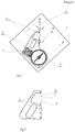
- Die Erfindung wird nun anhand der Zeichnung näher erläutert.
-
Fig. 1 zeigt eine Draufsicht auf den Kompass nach Anspruch 1, wobei- 1 eine Schlaufe,
- 2 eine Kompassplatte,
- 3 eine OL-Karte,
- 4 eine Kantenlinie der Platte (Strecken),
- 5 ein magnetischer Zeiger (Kompassnadel),
- 6 die Bewegungsrichtung im Gelände ist.
- In
Fig. 2 sind zusätzliche Elemente des Kompasses nach Anspruch 2 gezeigt, wobei- 7 ein Faden,
- 8 der 1. Punkt auf dem Faden,
- 9 der 2. Punkt auf dem Faden ist.
- Mit dem vorgeschlagenen Kompass erfolgt die Ermittlung des Azimuts vom KP A zum KP B wie folgt.
- Die Schlaufe 1 wird am Daumen umgelegt. Durch die Öffnung in der Platte wird die Platte 2 mit dem Daumen an die Karte 3 angedrückt. Der Läufer positioniert die Kompassplatte auf der Karte. Die Strecke AB auf der Karte (oder deren Teil) soll sich in der Aussparung der Platte und genau auf der Linie zwischen den Strecken der Kantenlinie 4 befinden. Danach dreht sich der Läufer um seine eigene Achse, bis sich die Kompassnadel 5 der Nord-Linie auf der Karte parallel eingestellt hat. Dabei sollen die Nord-Markierung N auf der Kompassnadel und die auf der Karte in die gleiche Richtung zeigen. Jetzt zeigt die Kantenlinie der Kompassplatte die Richtung 6 im Gelände vom KP A zum KP B.
- Mit seinem Blick verlängert der Läufer gedanklich diese Kantenlinie. Dabei überträgt er sie auf die vor ihm liegende Gegend. Danach kann er die Bewegung in der gewählten Richtung beginnen.
- Der Läufer übt das Laufen in Azimut (nach dem Richtungswinkel) abwechselnd mit dem Kartenlesen aus im betreffenden Bereich der Strecke AB, sowohl links als auch rechts von dieser Strecke. Er vergleicht die Orientierungsmarken der OL-Karte mit denjenigen im Gelände und wählt optimale Varianten der Fortbewegung.
- Bei der Hinzufügung des Fadens 7 in die Aussparung der Platte und beim Anlegen der Platte auf die Karte wird der Faden über der Strecke AB auf der Karte liegen. Dadurch können die Herstellung der Parallelität der zwei Strecken sowie das Laufen in Azimut (nach dem Richtungswinkel) vereinfacht werden.
- Bei der Hinzufügung eines farbigen Punkts 8 auf dem Faden kann der Punkt die aktuelle Position des Läufers auf der Karte angeben. Darüber hinaus ist dank dieses Punkts das Kartenlesen erleichtert.
- Bei der Hinzufügung des zweiten Punkts 9 auf den Faden in einem Abstand von 1 cm vom vorhergehenden Punkt wird der 2. Punkt die Stelle auf der Karte angeben, an die der Läufer nach 100 m des Geländes (bei einem Kartenmaßstab 1:10000) zur Kontrolle der zurückgelegten Strecke gelangen soll.
- Der Faden kann aus einem unmagnetischen Metall gefertigt sein. Damit sind die Festigkeit und die Wetterresistenz gewährleistet. Ein solches Metall kann z. B. rostfreier Stahl oder Titan sein.
Claims (1)
- Orientierungslauf-Kompass aus einer Kapsel mit einer Magnetnadel (5) und einer Platte (2), an der eine Schlaufe (1) befestigt ist, wobei mit dieser Schlaufe der Kompass am Finger gehalten werden kann, wobei ferner die Platte eine Kantenlinie (4) in Bewegungsrichtung (6) aufweist und die Verlängerung der Kantenlinie der Bewegungsrichtung durch die Mitte der Kapsel verläuft, wobei die Kompassplatte eine Aussparung aufweist, die den mittleren Teil der Kantenlinie (4) und teilweise die Ebene der Platte (2) umfasst, wobei ein Teil der Plattenfläche an den mittleren Teil der Kantenlinie angrenzt, dadurch gekennzeichnet, dass in der Aussparung zwischen den Strecken der Kantenlinie sich ein farbiger geradliniger Faden (7) befindet.
Applications Claiming Priority (1)
| Application Number | Priority Date | Filing Date | Title |
|---|---|---|---|
| RU2019105796A RU2701879C1 (ru) | 2019-02-28 | 2019-02-28 | Компас |
Publications (2)
| Publication Number | Publication Date |
|---|---|
| EP3702729A1 EP3702729A1 (de) | 2020-09-02 |
| EP3702729B1 true EP3702729B1 (de) | 2021-12-22 |
Family
ID=68170702
Family Applications (1)
| Application Number | Title | Priority Date | Filing Date |
|---|---|---|---|
| EP20155048.0A Not-in-force EP3702729B1 (de) | 2019-02-28 | 2020-02-03 | Kompass |
Country Status (2)
| Country | Link |
|---|---|
| EP (1) | EP3702729B1 (de) |
| RU (1) | RU2701879C1 (de) |
Families Citing this family (1)
| Publication number | Priority date | Publication date | Assignee | Title |
|---|---|---|---|---|
| RU2762239C1 (ru) * | 2021-03-22 | 2021-12-16 | Сергей Михайлович Хропов | Компас |
Family Cites Families (7)
| Publication number | Priority date | Publication date | Assignee | Title |
|---|---|---|---|---|
| US2336789A (en) * | 1940-11-21 | 1943-12-14 | Jonsson Arvid | Compass, particularly for orientation purposes |
| SE424372C (sv) * | 1981-01-12 | 1985-09-09 | Erik Bertil Norman | Orienteringskompass |
| FI78552C (fi) * | 1987-08-28 | 1989-08-10 | Suunto Oy | Orienteringskompass. |
| US4899453A (en) * | 1988-09-27 | 1990-02-13 | The United States Of America As Represented By The Secretary Of The Army | Compass with LED illumination |
| US5146687A (en) * | 1991-02-25 | 1992-09-15 | Bjorn Kjellstrom | Compass |
| RU2073204C1 (ru) * | 1992-08-26 | 1997-02-10 | Александр Николаевич Козлов | Компас для спортивного ориентирования |
| US8322041B1 (en) * | 2011-07-13 | 2012-12-04 | Fenix Outdoor AB | Compass with improved declination adjustment |
-
2019
- 2019-02-28 RU RU2019105796A patent/RU2701879C1/ru not_active IP Right Cessation
-
2020
- 2020-02-03 EP EP20155048.0A patent/EP3702729B1/de not_active Not-in-force
Also Published As
| Publication number | Publication date |
|---|---|
| EP3702729A1 (de) | 2020-09-02 |
| RU2701879C1 (ru) | 2019-10-02 |
Similar Documents
| Publication | Publication Date | Title |
|---|---|---|
| DE2918930A1 (de) | Kollisionsschutzeinrichtung | |
| DE2157319C2 (de) | Zusammenstoß-Verhütungseinrichtung | |
| DE69603906T2 (de) | Eine die Richtung eines vorherbestimmten geographischen Orts anzeigende Vorrichtung | |
| EP3702729A1 (de) | Kompass | |
| DE7321508U (de) | Regattenkalkulator fuer segelboote | |
| EP3608631B1 (de) | Kompass | |
| DE69009500T2 (de) | Verbesserte head-up-anzeigesysteme. | |
| DE2205938A1 (de) | Winkelmesser | |
| DE202011106754U1 (de) | Golfputter mit Putterkopf | |
| DE2011821A1 (de) | Navigationsgerät, insbesondere für die Schiffahrt | |
| DE69709486T2 (de) | Horizontalgeschwindigkeitsanzeiger für Drehflügel-Luftfahrzeug | |
| DE2313521A1 (de) | Richtungsgeber fuer landgebundene fortbewegung | |
| DE73473C (de) | Instrument zur Herstellung perspectivischer Zeichnungen aus Grundrifs und Aufrifs | |
| DE2233611C3 (de) | Segelbootkompaß | |
| DE3720431A1 (de) | Parallellineal | |
| DE367384C (de) | Einrichtung zum Richten von Luftfahrzeugen | |
| AT21825B (de) | Horizontal- und Vertikal-Meßvorrichtung. | |
| DE920391C (de) | Fernrohr mit Orientierungstafel | |
| DE727939C (de) | Anzeigeeinrichtung zur Fuehrung eines Fahrzeuges auf einer Leitlinie | |
| DE19834793A1 (de) | Navigationsvorrichtung für die Schifffahrt | |
| DE928980C (de) | Geraet zum Ermitteln der Winkelkorrektur, die an dem fuer den Bild-hauptpunkt eines Messbildes gueltigen Seitenwinkel anzubringen ist, um den Seitenwinkel fuer einen ausserhalb der Bildmitte liegenden Bildpunkt zu erhalten | |
| DE73862C (de) | Instrument zur Bestimmung der Deviationen von Compassen | |
| DE416341C (de) | Richtungsanzeiger | |
| DE802102C (de) | Vorrichtung zur Dreiteilung eines Winkels | |
| DE102006010333B4 (de) | Lawinenkundlicher Kompaß |
Legal Events
| Date | Code | Title | Description |
|---|---|---|---|
| PUAI | Public reference made under article 153(3) epc to a published international application that has entered the european phase |
Free format text: ORIGINAL CODE: 0009012 |
|
| STAA | Information on the status of an ep patent application or granted ep patent |
Free format text: STATUS: THE APPLICATION HAS BEEN PUBLISHED |
|
| AK | Designated contracting states |
Kind code of ref document: A1 Designated state(s): AL AT BE BG CH CY CZ DE DK EE ES FI FR GB GR HR HU IE IS IT LI LT LU LV MC MK MT NL NO PL PT RO RS SE SI SK SM TR |
|
| AX | Request for extension of the european patent |
Extension state: BA ME |
|
| STAA | Information on the status of an ep patent application or granted ep patent |
Free format text: STATUS: REQUEST FOR EXAMINATION WAS MADE |
|
| 17P | Request for examination filed |
Effective date: 20210205 |
|
| RBV | Designated contracting states (corrected) |
Designated state(s): AL AT BE BG CH CY CZ DE DK EE ES FI FR GB GR HR HU IE IS IT LI LT LU LV MC MK MT NL NO PL PT RO RS SE SI SK SM TR |
|
| GRAP | Despatch of communication of intention to grant a patent |
Free format text: ORIGINAL CODE: EPIDOSNIGR1 |
|
| STAA | Information on the status of an ep patent application or granted ep patent |
Free format text: STATUS: GRANT OF PATENT IS INTENDED |
|
| INTG | Intention to grant announced |
Effective date: 20210722 |
|
| RIN1 | Information on inventor provided before grant (corrected) |
Inventor name: CHROPOV, SERGEY M. Inventor name: CHROPOV, ANDREY S. Inventor name: FILIMONOV, MIKHAIL T. |
|
| GRAS | Grant fee paid |
Free format text: ORIGINAL CODE: EPIDOSNIGR3 |
|
| GRAA | (expected) grant |
Free format text: ORIGINAL CODE: 0009210 |
|
| STAA | Information on the status of an ep patent application or granted ep patent |
Free format text: STATUS: THE PATENT HAS BEEN GRANTED |
|
| AK | Designated contracting states |
Kind code of ref document: B1 Designated state(s): AL AT BE BG CH CY CZ DE DK EE ES FI FR GB GR HR HU IE IS IT LI LT LU LV MC MK MT NL NO PL PT RO RS SE SI SK SM TR |
|
| REG | Reference to a national code |
Ref country code: GB Ref legal event code: FG4D Free format text: NOT ENGLISH |
|
| REG | Reference to a national code |
Ref country code: CH Ref legal event code: EP |
|
| REG | Reference to a national code |
Ref country code: DE Ref legal event code: R096 Ref document number: 502020000458 Country of ref document: DE |
|
| REG | Reference to a national code |
Ref country code: AT Ref legal event code: REF Ref document number: 1457344 Country of ref document: AT Kind code of ref document: T Effective date: 20220115 |
|
| REG | Reference to a national code |
Ref country code: IE Ref legal event code: FG4D Free format text: LANGUAGE OF EP DOCUMENT: GERMAN |
|
| REG | Reference to a national code |
Ref country code: LT Ref legal event code: MG9D |
|
| PG25 | Lapsed in a contracting state [announced via postgrant information from national office to epo] |
Ref country code: RS Free format text: LAPSE BECAUSE OF FAILURE TO SUBMIT A TRANSLATION OF THE DESCRIPTION OR TO PAY THE FEE WITHIN THE PRESCRIBED TIME-LIMIT Effective date: 20211222 Ref country code: LT Free format text: LAPSE BECAUSE OF FAILURE TO SUBMIT A TRANSLATION OF THE DESCRIPTION OR TO PAY THE FEE WITHIN THE PRESCRIBED TIME-LIMIT Effective date: 20211222 Ref country code: FI Free format text: LAPSE BECAUSE OF FAILURE TO SUBMIT A TRANSLATION OF THE DESCRIPTION OR TO PAY THE FEE WITHIN THE PRESCRIBED TIME-LIMIT Effective date: 20211222 Ref country code: BG Free format text: LAPSE BECAUSE OF FAILURE TO SUBMIT A TRANSLATION OF THE DESCRIPTION OR TO PAY THE FEE WITHIN THE PRESCRIBED TIME-LIMIT Effective date: 20220322 |
|
| REG | Reference to a national code |
Ref country code: NL Ref legal event code: MP Effective date: 20211222 |
|
| PG25 | Lapsed in a contracting state [announced via postgrant information from national office to epo] |
Ref country code: SE Free format text: LAPSE BECAUSE OF FAILURE TO SUBMIT A TRANSLATION OF THE DESCRIPTION OR TO PAY THE FEE WITHIN THE PRESCRIBED TIME-LIMIT Effective date: 20211222 Ref country code: NO Free format text: LAPSE BECAUSE OF FAILURE TO SUBMIT A TRANSLATION OF THE DESCRIPTION OR TO PAY THE FEE WITHIN THE PRESCRIBED TIME-LIMIT Effective date: 20220322 Ref country code: LV Free format text: LAPSE BECAUSE OF FAILURE TO SUBMIT A TRANSLATION OF THE DESCRIPTION OR TO PAY THE FEE WITHIN THE PRESCRIBED TIME-LIMIT Effective date: 20211222 Ref country code: HR Free format text: LAPSE BECAUSE OF FAILURE TO SUBMIT A TRANSLATION OF THE DESCRIPTION OR TO PAY THE FEE WITHIN THE PRESCRIBED TIME-LIMIT Effective date: 20211222 Ref country code: GR Free format text: LAPSE BECAUSE OF FAILURE TO SUBMIT A TRANSLATION OF THE DESCRIPTION OR TO PAY THE FEE WITHIN THE PRESCRIBED TIME-LIMIT Effective date: 20220323 |
|
| PG25 | Lapsed in a contracting state [announced via postgrant information from national office to epo] |
Ref country code: NL Free format text: LAPSE BECAUSE OF FAILURE TO SUBMIT A TRANSLATION OF THE DESCRIPTION OR TO PAY THE FEE WITHIN THE PRESCRIBED TIME-LIMIT Effective date: 20211222 |
|
| PG25 | Lapsed in a contracting state [announced via postgrant information from national office to epo] |
Ref country code: SM Free format text: LAPSE BECAUSE OF FAILURE TO SUBMIT A TRANSLATION OF THE DESCRIPTION OR TO PAY THE FEE WITHIN THE PRESCRIBED TIME-LIMIT Effective date: 20211222 Ref country code: SK Free format text: LAPSE BECAUSE OF FAILURE TO SUBMIT A TRANSLATION OF THE DESCRIPTION OR TO PAY THE FEE WITHIN THE PRESCRIBED TIME-LIMIT Effective date: 20211222 Ref country code: RO Free format text: LAPSE BECAUSE OF FAILURE TO SUBMIT A TRANSLATION OF THE DESCRIPTION OR TO PAY THE FEE WITHIN THE PRESCRIBED TIME-LIMIT Effective date: 20211222 Ref country code: PT Free format text: LAPSE BECAUSE OF FAILURE TO SUBMIT A TRANSLATION OF THE DESCRIPTION OR TO PAY THE FEE WITHIN THE PRESCRIBED TIME-LIMIT Effective date: 20220422 Ref country code: ES Free format text: LAPSE BECAUSE OF FAILURE TO SUBMIT A TRANSLATION OF THE DESCRIPTION OR TO PAY THE FEE WITHIN THE PRESCRIBED TIME-LIMIT Effective date: 20211222 Ref country code: EE Free format text: LAPSE BECAUSE OF FAILURE TO SUBMIT A TRANSLATION OF THE DESCRIPTION OR TO PAY THE FEE WITHIN THE PRESCRIBED TIME-LIMIT Effective date: 20211222 Ref country code: CZ Free format text: LAPSE BECAUSE OF FAILURE TO SUBMIT A TRANSLATION OF THE DESCRIPTION OR TO PAY THE FEE WITHIN THE PRESCRIBED TIME-LIMIT Effective date: 20211222 |
|
| PG25 | Lapsed in a contracting state [announced via postgrant information from national office to epo] |
Ref country code: PL Free format text: LAPSE BECAUSE OF FAILURE TO SUBMIT A TRANSLATION OF THE DESCRIPTION OR TO PAY THE FEE WITHIN THE PRESCRIBED TIME-LIMIT Effective date: 20211222 |
|
| REG | Reference to a national code |
Ref country code: DE Ref legal event code: R119 Ref document number: 502020000458 Country of ref document: DE |
|
| PG25 | Lapsed in a contracting state [announced via postgrant information from national office to epo] |
Ref country code: MC Free format text: LAPSE BECAUSE OF FAILURE TO SUBMIT A TRANSLATION OF THE DESCRIPTION OR TO PAY THE FEE WITHIN THE PRESCRIBED TIME-LIMIT Effective date: 20211222 Ref country code: IS Free format text: LAPSE BECAUSE OF FAILURE TO SUBMIT A TRANSLATION OF THE DESCRIPTION OR TO PAY THE FEE WITHIN THE PRESCRIBED TIME-LIMIT Effective date: 20220422 |
|
| REG | Reference to a national code |
Ref country code: BE Ref legal event code: MM Effective date: 20220228 |
|
| PLBE | No opposition filed within time limit |
Free format text: ORIGINAL CODE: 0009261 |
|
| STAA | Information on the status of an ep patent application or granted ep patent |
Free format text: STATUS: NO OPPOSITION FILED WITHIN TIME LIMIT |
|
| PG25 | Lapsed in a contracting state [announced via postgrant information from national office to epo] |
Ref country code: LU Free format text: LAPSE BECAUSE OF NON-PAYMENT OF DUE FEES Effective date: 20220203 Ref country code: DK Free format text: LAPSE BECAUSE OF FAILURE TO SUBMIT A TRANSLATION OF THE DESCRIPTION OR TO PAY THE FEE WITHIN THE PRESCRIBED TIME-LIMIT Effective date: 20211222 Ref country code: AL Free format text: LAPSE BECAUSE OF FAILURE TO SUBMIT A TRANSLATION OF THE DESCRIPTION OR TO PAY THE FEE WITHIN THE PRESCRIBED TIME-LIMIT Effective date: 20211222 |
|
| 26N | No opposition filed |
Effective date: 20220923 |
|
| PG25 | Lapsed in a contracting state [announced via postgrant information from national office to epo] |
Ref country code: FR Free format text: LAPSE BECAUSE OF NON-PAYMENT OF DUE FEES Effective date: 20220222 |
|
| PG25 | Lapsed in a contracting state [announced via postgrant information from national office to epo] |
Ref country code: IE Free format text: LAPSE BECAUSE OF NON-PAYMENT OF DUE FEES Effective date: 20220203 Ref country code: DE Free format text: LAPSE BECAUSE OF NON-PAYMENT OF DUE FEES Effective date: 20220901 |
|
| PG25 | Lapsed in a contracting state [announced via postgrant information from national office to epo] |
Ref country code: SI Free format text: LAPSE BECAUSE OF FAILURE TO SUBMIT A TRANSLATION OF THE DESCRIPTION OR TO PAY THE FEE WITHIN THE PRESCRIBED TIME-LIMIT Effective date: 20211222 Ref country code: BE Free format text: LAPSE BECAUSE OF NON-PAYMENT OF DUE FEES Effective date: 20220228 |
|
| PG25 | Lapsed in a contracting state [announced via postgrant information from national office to epo] |
Ref country code: IT Free format text: LAPSE BECAUSE OF FAILURE TO SUBMIT A TRANSLATION OF THE DESCRIPTION OR TO PAY THE FEE WITHIN THE PRESCRIBED TIME-LIMIT Effective date: 20211222 |
|
| REG | Reference to a national code |
Ref country code: CH Ref legal event code: PL |
|
| PG25 | Lapsed in a contracting state [announced via postgrant information from national office to epo] |
Ref country code: LI Free format text: LAPSE BECAUSE OF NON-PAYMENT OF DUE FEES Effective date: 20230228 Ref country code: CH Free format text: LAPSE BECAUSE OF NON-PAYMENT OF DUE FEES Effective date: 20230228 |
|
| PG25 | Lapsed in a contracting state [announced via postgrant information from national office to epo] |
Ref country code: MK Free format text: LAPSE BECAUSE OF FAILURE TO SUBMIT A TRANSLATION OF THE DESCRIPTION OR TO PAY THE FEE WITHIN THE PRESCRIBED TIME-LIMIT Effective date: 20211222 Ref country code: CY Free format text: LAPSE BECAUSE OF FAILURE TO SUBMIT A TRANSLATION OF THE DESCRIPTION OR TO PAY THE FEE WITHIN THE PRESCRIBED TIME-LIMIT Effective date: 20211222 |
|
| PG25 | Lapsed in a contracting state [announced via postgrant information from national office to epo] |
Ref country code: HU Free format text: LAPSE BECAUSE OF FAILURE TO SUBMIT A TRANSLATION OF THE DESCRIPTION OR TO PAY THE FEE WITHIN THE PRESCRIBED TIME-LIMIT; INVALID AB INITIO Effective date: 20200203 |
|
| PG25 | Lapsed in a contracting state [announced via postgrant information from national office to epo] |
Ref country code: MT Free format text: LAPSE BECAUSE OF FAILURE TO SUBMIT A TRANSLATION OF THE DESCRIPTION OR TO PAY THE FEE WITHIN THE PRESCRIBED TIME-LIMIT Effective date: 20211222 |
|
| GBPC | Gb: european patent ceased through non-payment of renewal fee |
Effective date: 20240203 |
|
| PG25 | Lapsed in a contracting state [announced via postgrant information from national office to epo] |
Ref country code: GB Free format text: LAPSE BECAUSE OF NON-PAYMENT OF DUE FEES Effective date: 20240203 |
|
| PG25 | Lapsed in a contracting state [announced via postgrant information from national office to epo] |
Ref country code: GB Free format text: LAPSE BECAUSE OF NON-PAYMENT OF DUE FEES Effective date: 20240203 |
|
| PGFP | Annual fee paid to national office [announced via postgrant information from national office to epo] |
Ref country code: AT Payment date: 20250417 Year of fee payment: 5 |
|
| PG25 | Lapsed in a contracting state [announced via postgrant information from national office to epo] |
Ref country code: TR Free format text: LAPSE BECAUSE OF FAILURE TO SUBMIT A TRANSLATION OF THE DESCRIPTION OR TO PAY THE FEE WITHIN THE PRESCRIBED TIME-LIMIT Effective date: 20211222 |
|
| PG25 | Lapsed in a contracting state [announced via postgrant information from national office to epo] |
Ref country code: AT Free format text: LAPSE BECAUSE OF NON-PAYMENT OF DUE FEES Effective date: 20250203 |
|
| REG | Reference to a national code |
Ref country code: AT Ref legal event code: MM01 Ref document number: 1457344 Country of ref document: AT Kind code of ref document: T Effective date: 20250203 |