EP0860787A2 - Kartendarstellungssystem - Google Patents
Kartendarstellungssystem Download PDFInfo
- Publication number
- EP0860787A2 EP0860787A2 EP98410014A EP98410014A EP0860787A2 EP 0860787 A2 EP0860787 A2 EP 0860787A2 EP 98410014 A EP98410014 A EP 98410014A EP 98410014 A EP98410014 A EP 98410014A EP 0860787 A2 EP0860787 A2 EP 0860787A2
- Authority
- EP
- European Patent Office
- Prior art keywords
- geographic information
- information
- server
- servers
- geographic
- Prior art date
- Legal status (The legal status is an assumption and is not a legal conclusion. Google has not performed a legal analysis and makes no representation as to the accuracy of the status listed.)
- Withdrawn
Links
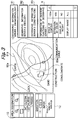
Images


Classifications
-
- G—PHYSICS
- G01—MEASURING; TESTING
- G01C—MEASURING DISTANCES, LEVELS OR BEARINGS; SURVEYING; NAVIGATION; GYROSCOPIC INSTRUMENTS; PHOTOGRAMMETRY OR VIDEOGRAMMETRY
- G01C21/00—Navigation; Navigational instruments not provided for in groups G01C1/00 - G01C19/00
- G01C21/26—Navigation; Navigational instruments not provided for in groups G01C1/00 - G01C19/00 specially adapted for navigation in a road network
- G01C21/34—Route searching; Route guidance
-
- G—PHYSICS
- G06—COMPUTING OR CALCULATING; COUNTING
- G06F—ELECTRIC DIGITAL DATA PROCESSING
- G06F16/00—Information retrieval; Database structures therefor; File system structures therefor
- G06F16/20—Information retrieval; Database structures therefor; File system structures therefor of structured data, e.g. relational data
- G06F16/24—Querying
- G06F16/248—Presentation of query results
-
- G—PHYSICS
- G06—COMPUTING OR CALCULATING; COUNTING
- G06F—ELECTRIC DIGITAL DATA PROCESSING
- G06F16/00—Information retrieval; Database structures therefor; File system structures therefor
- G06F16/20—Information retrieval; Database structures therefor; File system structures therefor of structured data, e.g. relational data
- G06F16/29—Geographical information databases
Definitions
- the present invention relates to a map display system which can display geographic information in computers on a wide area network to a client.
- a single storage medium is recorded position information such as roads and shopping areas and the like while a map range is previously limited.
- position information such as roads and shopping areas and the like while a map range is previously limited.
- a map range is previously limited.
- an operator can select display information.
- the conventional geographic information is provided from one medium or a server at one place.
- a various kinds of geographic information servers existing on the internet are not linked to each other as a geographic information system, but they are isolated respectively.
- a client when a client searches one geographic information server, a client must again connect to another geographic information server as for searching geographic information of an area portion no-provided by the server. For example, if a client intends to search the town level road information during the searching of a geographic information server which was specialized in the country level road information, a client must change the connection to the server to connection to another geographic information server which was specialized in the town level road information. Furthermore, if a client intends to search position information of shopping areas, one must change the connection to the server to connection to another geographic information server which was specialized in those information.
- one geographic information server is linked to a plurality of geographic information servers to provide one integrated geographic information to a client.
- an object of the present invention is to provide a map display system in which a client can display various geographic information with a plurality of geographic information servers on the network.
- the present invention provides a map display system including a plurality of geographic information servers, a geographic information search server searching the geographic information servers and clients displaying a map, connected to each other through network, and displaying geographic information in the geographic information servers by the clients; wherein the geographic information search server includes an index information database containing index information of geographic information provided by each geographic information server, and a geographic information server search unit searching a plurality of geographic information servers and generating a combination list containing information of existential place of the plurality of geographic information servers, the clients including a geographic information search server access unit for obtaining the combination list, a geographic information server access unit for obtaining a plurality of geographic information from the plurality of geographic information servers designated by the combination list and an user interface control unit for displaying the obtained plurality of geographic information while superimposing them so that the coordinates thereof coincide with each other on the same screen.
- the client in map display system can display geographic information in all of the geographic information server on network.
- the index information include information of image range common to all of the geographic information servers and information of inherent functions of each of the geographic information servers.
- the information of image range of the index information includes items of a name of district of the geographic information, display range, display contents and maximum and minimum scales.
- the client can clearly know the geographic information possible provided by each geographic information server.
- the combination list further comprises a parameter for the information of image range and a parameter for the information of inherent functions.
- the geographic information server can generate image data in accordance with parameters in the index information.
- the geographic information servers includes a geographic information database containing the geographic information and a geographic information control unit for searching the geographic information by using the geographic information database, and the geographic information control unit converts the geographic information into image data of a standard graphics data format and sends the image data to the clients.
- a client can easily display a plurality of imaae data at image level while superimposing the data.
- a client can utilize the geographic information as image data in background or utilize it while superimposing image having transparent attributes.
- the image data is standard graphics data format and the client executes only image operation, the client's software can easier create. And since the logical structure data possessed by the server is not stolen from the network, the security is high.
- the coordinate system for indicating image position of an image object may be a unity coordinate system.
- the client can easily superimpose the maps provided by different servers.
- the client may convert image data with one coordinate system to image data with another coordinate. Thus, if the coordinate is not unified, the client can superimpose the maps.
- the parameter of combination list may include converting parameters for converting image data.
- the geographic information control unit generates the image data in accordance with a parameter based on the index information commanded by the clients.
- the client need not generates and processes the image data.
- the geographic information control unit previously sends information of inherent functions in the index information possible provided the unit itself to the clients.
- a user interface control unit a user interface which can be selected by an operator for items of inherent functions of index information can be generated.
- a parameter of a combination list previously received from a geographic information search server can be changed on a client side and the client can directly command the parameter to a geographic information server.
- the clients further comprise a parameter holding unit storing parameters based on the index information.
- the geographic information server since the client can cut the connection to the geographic information server at the time when reception of image data has been completed, the geographic information server need not to have a parameter holding region to the access from a unspecified number of clients. It is desirable that image data sent by the geographic information server furthermore has link information to other servers. Thus, the same functions as that of hyperlink in WWW and of a clickable map can be implemented.
- the geographic information search server access unit in the client accesses to the geographic information search servers in order that the clients obtain the combination list again when a map outside the range of the index information is demanded.
- the server can notice the fact that the demanded area is outside the display possible area to the client.
- the geographic information servers further include the index information database and the geographic information server search unit, and the geographic information server search unit is constituted so that when a map outside the range of the index information is demanded, the server search unit searches the corresponding other geographic information servers by using the index information database, generates the combination list and sends the list to the clients.
- the client can display the display condition in common with all of geographic information servers. Further, since inherent functions of the geographic information servers are also used with an integrated user interface unit, a seamless operational environment for search and display can be provided.
- the geographic information server further includes the geographic information server access unit and obtains geographic information from a designated other geographic information servers by using the geographic information server access unit in accordance with the combination list.
- the geographic information server including the geographic information server access unit can send the combination list including items provided by only the other geographic information server although it have no contents of image data.
- the servers can be hierarchically formed, whereby a more efficient group of geographic servers can be provided.
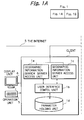
- a plurality of geographic information servers 3, a geographic information search server 2 searching the geographic information server and a client 1 displaying a map are connected to each other through the internet 5.
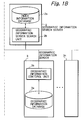
- the geographic information server 3 includes a geographic information database 3a storing geographic information and a geographic information control unit 3b converting the geographic information to image data and sending the information to a client 1.
- the geographic information control unit 3b effects functions of the searching of a geographic information from the geographic information database 3a, the generation of a geographic information in accordance with the parameters of index information, the conversion of the geographic information to image data and the transmission of the image data to clients.
- the image data is embodied as a standard graphics data format such as POST SCRIPT (Trademark of Adobe System Inc.).
- the geographic information control unit 3b converts geographic information to the image data, thereby absorbing differences of the specifications of the geographic information. This function of conversion can be provided as a middleware, thereby can be relatively easily mounted on many existing geographic information systems.
- the coordinate system for indicating image position of image object employs a coordinate system unifying an origin position and a scale.
- the coordinate system is the positioning system WGS-84 used in GPS(Global Positioning System).
- the client can superimpose the maps by converting image data with one coordinate system to image data with another coordinate.
- the display of an image is performed on an appropriate scale in accordance with scaling up or scaling down based on the parameter of the display range of the index information. For example, in a scaled-up map, even narrow roads can be displayed, while in a scaled-down map, only main roads can be displayed.
- the index information includes common items in the whole geographic information servers, and items of inherent functions in each geographic information server.
- the common items include the names of areas or districts, the range of display, the contents of display and the maximum or minimum scale. Parameters can be designated with respect to the respective items.
- a geographic information server when accessed from a client, it sends items of inherent functions of index information possible provided by server itself.
- the client can display selectable user interfaces for an operator.
- the operator can understand the range of geographic information possible provided by the geographic information server, and can directly command the change of parameters.
- the geographic information server 3 is concretely implemented by adding functions to the WWW server.
- the communication protocol between the geographic information server 3 and the client 1 is implemented in a form based on the HTTP (Hyper Text Transfer Protocol).
- the geographic information search server 2 includes an index information database 2a including index information and a geographic information server search unit 2b generating a combination list of a plurality of geographic information servers.
- the index information database 2a stores index information possible provided by geographic information server itself every geographic information server.
- the geographic information server search unit 2b determines combination of a plurality of geographic information servers most suitable for the search condition by clients, parameters based on items of inherent functions of the geographic information servers in index information and parameters based on common items of the whole geographic information servers in index information.
- the geographic information search server 2 sends the combination list of these determined information to clients.
- the above-mentioned URL designates address of geographic information of geographic information servers. Further, the parameters are information of inherent functions of index information possible displayed by the geographic information server.
- MRL Multiple Resource Locator
- the MRL are included parameters of information of image range which are common to geographic information servers.
- the geographic information search server 2 is expansion of functions of the server of WWW.
- the client 1 has a geographic information search server access unit 1a, a geographic information server access unit 1c, a user interface control unit 1b and parameter holding unit 1d.
- the geographic information search server access unit la is a unit for obtaining a combination list.
- the geographic information search server access unit la sends the search condition to the geographic information search server 2 and receives a combination list of the geographic information server 3 from the geographic information search server 2. After that, the geographic information search server access unit 1a sends the combination list to the user interface control unit 1b.
- the geographic information search server access unit 1a can be relatively easily implemented by a WWW browser.
- the geographic information server access unit 1c obtains a plurality of geographic information from a plurality of a geographic information server and displays the obtained geographic information on a display unit 6 while superimposing the information with the coordinates coincided with each other.
- Each of geographic information server access unit 1c corresponds to each of geographic information servers 3n respectively.
- the geographic information server access unit 1c obtains URL sent from the user interface control unit 1b and sends a parameter of index information to the corresponding geographic information server 3.
- geographic information server access unit 1c receives information of inherent functions of index information and image data based on the post script format from the geographic information server 3n, and sends these information to the user interface control unit 1b and the display unit 6.
- the user interface control unit 1b is a unit for controlling the geographic information server access unit 1c in accordance with command from an operator and information from the geographic information search server access unit la.
- the user interface control unit 1b separates the combination list received from the geographic information search server access unit la into URL of every geographic information server 3n. Then, the user interface control unit 1b sends the parameters of information of inherent functions of the respective geographic information servers and the parameters of information within a range of image common to the whole geographic information servers 3n, to the respective geographic information server access unit 1c. Further, the user interface control unit 1b provides an operator with user interface of functions of servers, such as a text input column or button, in accordance with items of inherent information of index information.
- the user interface control unit 1b performs display of a selector button, generation of selection, generation of a text input area, generation of a coordinate input requiring item and transmission of the fact that the above-mentioned factors have been operated by an operator to servers.
- the user interface control unit 1b effects the same functions as the browser in WWW. All of the actual processing is carried out on a geographic information server's side.
- the parameter holding unit 1d stores a display state or the like of a client.
- the parameter holding unit 1d stores a combination list and information of inherent functions of each geographic information server.
- the existing parameter state with respect to information of inherent functions of index information is updated in parameter of information of inherent functions of the combination list.
- the existing parameter state with respect to information of existing image range is also updated in parameter of information of image range of the combination list.
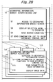
- Fig. 2 is a sequence diagram of Fig. 1.
- the geographic information search server access unit la has access to the geographic information search server 2 (S1).
- the geographic information server search unit 2b of the accessed geographic information server 2 generates a selection menu and sends it to a client 1 (S2).
- the geographic information search server access unit la of the client 1 displays the received selection menu to an operator (S3). After that, the geographic information search server access unit la waits for a command from the operator and sends a search condition based on the command to the geographic information search server 2 (S4).
- the geographic information server search unit 2b which received the search condition searches using the index information database 2a (S5).
- a combination list which stored a plurality of geographic information server which is suited for the condition and the parameter with respective to the index information is sent to the client 1 (S6).
- the geographic information search server access unit 1a which received the combination list sends the combination list to the user interface control unit 1b (S7).
- the user interface control unit 1b In order to have simultaneous access to a plurality of geographic information servers 31, 32 and 33 of the combination list, the user interface control unit 1b generates a plurality of geographic information server access unit 1c1, 1c2 and 1c3 and starts up (S8). This procedure is the same procedure as the parent process generates a plurality of the child process.
- the generated geographic information server access unit 1c accesses to the corresponding geographic information server 3 (S9).
- the geographic information server access unit 1c1 corresponds to the geographic information server 31
- the geographic information server access unit 1c2 corresponds to the geographic information server 32
- the geographic information server access unit 1c3 corresponds to the geographic information server 33, respectively.
- the sequence of the geographic information server 31 will now be described. Both the geographic information servers 32 and 33 also have the same constitution and sequence.
- a geographic information control unit 31b of the accessed geographic information server 31 sends information of inherent functions of index information possible previously provided by the control unit itself (S10).
- the geographic information server access unit 1c1 of the client 1 received sends the information of inherent functions from the geographic information server 31 (S11).
- the information of inherent functions of index information may be previously received from the geographic information search server 2.
- the combination list received from the geographic information search server 2 includes only URL of a plurality of geographic information servers and information of common image range and can also receive the information of inherent functions in S11.
- the user interface control unit 1b generates a user interface for controlling a map image, such as a text field and a button, in accordance with a plurality of received information of inherent functions (S12). Further, the user interface control unit 1b displays only one setting button for information of image range common to the all of the geographic information servers in index information.
- the user interface control unit 1b separates the combination list every geographic information search server. And, the control unit 1b sends the parameters of index information to the respectively corresponding geographic information server access unit (S13).
- the user interface control unit 1b send the parameter to all of the geographic information server access unit 1c. However, after that, the control unit 1b sends the parameter to only a geographic information server in which parameter was changed. Consequently, the transmission of image data from the geographic information server which does not need to image can be omitted.
- the geographic information server access unit 1c1 receiving parameter of index information sends the parameter of the index information to a corresponding geographic information server 31 (S15).
- a geographic information control unit 31b of the geographic information server 31 which received the parameter of index information searches geographic information from a geographic information database 31a in accordance with the parameter (S16). The searched geographic information generates geographic information in accordance with the parameter. After that, the geographic information control unit 31b converts the geographic information to image data and sends the image data to a client (S17).
- the geographic information server access unit 101 which received image data displays the image data superimposed on the same coordinate on the same window of a display unit 6 together with other server access unit (S18).
- the geographic information server access unit 1c1 has the map forming process (cartography) for displaying image data of a graphics data format.
- the client 1 waits for a command from an operator (S19). After that, when change of image range (enlargement, reduction and scroll and the like) is commanded, a parameter of the information of the corresponding image range is changed (S20). Then the operations from S13 to S20 are repeated.
- the user interface control unit 1b can again obtain the combination list of the plurality of geographic information server 3 through the geographic information search access unit la.
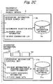
- Fig. 3 shows an image display displayed by a user interface control unit 1b and a geographic information server access unit 1c.
- all information of a geographic information server with geomorphologic information, a geographic information server with geologic information and a geographic information server with construction information is displayed while being superimposed on the same coordinate.
- the geographic information server of the geomorphologic information provides image data of contour lines (geomorphology) 81a
- the geographic information server of the geologic information provides image data of sand (geology) 82a
- the geographic information server of construction information provides image data of communication cables (construction) 83a, respectively.
- Tabs 81, 82 and 83 corresponding to the respective geographic information servers are displayed in Fig. 3. When any one of these tabs is selected, the item 9 for information of an inherent function of the selected geographic information server is displayed and the parameter in the item 9 can be changed.
- the parameter of information of image range common to all servers can be displayed and changed.
- a clickable pointer 10 is displayed a clickable pointer 10, and enlargement and reduction of map can be easily performed by operating an operating unit 7 such as a mouse or the like.
- GO button 11 can access to the geographic information search server 2 by operator's command.
- URL information 12 displays URL of the geographic information server included in information of image data pointed to a map by using a mouse pointer.
- the geographic information of the geographic information server can be displayed by using GO button 11.
- the function generally designated as a clickable map in WWW can be implemented.
- Graphics to be imaged can have linkage to data of other servers which correspond to hyperlink in WWW, as a clickable map.
- the index information stored in the geographic information search servers can be treated as one kind of geographic information since it includes the information of existential place of the geographic information server and information of image range such as display area, display contents and the like.
- the geographic information server including geographic information server search unit is one that includes an index information database and geographic information server search unit and a geographic information server access unit. Even though a range outside the index information possible provided by the geographic information server is desired, the geographic information server search unit searches the corresponding other geographic information servers using an index information database, obtains geographic information from the searched other geographic information servers using a geographic information server access unit and sends the obtained geographic information to a client by the geographic information control unit.
- the geographic information server used as such geographic information search server will be able to add the MRL to linkage information added to each object of image data.
- the MRL can be added to the object as linkage information.
- image data with the above-mentioned structure can be sent to a client as a result of search of the geographic information server.
- the range of index information of a geographic information server may be imaged as a boarder line and selected.
- the MRL corresponding to the selected part can be accessed.
- one of search conditions in the range which is displayed for clients is searched.
- the MRL of the result of search may be within the object of the whole image data to be sent.
- the geographic information server When an operator demands information of an area which cannot be imaged to a geographic information server which had already been accessed, the geographic information server automatically obtain the search result from a geographic information server search unit used and can have access to a new server group again in accordance with the search result. Consequently, if an operator once sets a search condition, the operator can automatically have access to appropriate geographic information without the intention of performing any search when the display area is transferred and its enlargement and reduction are performed.
- Fig. 4 shows a hierarchical tree structure of the geographic information servers and geographic information search servers.
- a geographic information search server also can search other geographic information search server. And these geographic information search servers can be linked to each other. Thus, it is not necessary for one geographic information search server to have index information of all of geographic information servers.
- the geographic information search server can constitute geographic information servers from a geographic information server with a wide area geographic information to a geographic information server with a narrow area geographic information. That is, when the display area is enlarged, a server with further detailed data can be searched in accordance with the place and scale.
- the present invention has geographic information search servers which generate a combination list of a plurality of geographic information servers and displays geographic information obtained from the plurality of geographic information servers while superimposing the information, various geographic information which cannot be provided by one geographic information server can be provided from a plurality of geographic information servers on the network.
- the geographic information server converts geographic information to image data of a standard graphics data format and sends the data, a client can easily display a plurality of image data at the image level while superimposing it.
- the function of conversion can be relatively easily provided as a middleware of the existing the geographic information server, and a plurality of geographic information server groups with different specifications from each other can be used as geographic information servers with the same specifications.
- the geographic information server also includes the geographic information server search unit, the geographic information server group can be hierarchically formed, whereby a more userfriendly internet application can be provided.
Landscapes
- Engineering & Computer Science (AREA)
- Remote Sensing (AREA)
- Theoretical Computer Science (AREA)
- Radar, Positioning & Navigation (AREA)
- Physics & Mathematics (AREA)
- General Physics & Mathematics (AREA)
- Databases & Information Systems (AREA)
- General Engineering & Computer Science (AREA)
- Data Mining & Analysis (AREA)
- Automation & Control Theory (AREA)
- Computational Linguistics (AREA)
- Information Retrieval, Db Structures And Fs Structures Therefor (AREA)
- Processing Or Creating Images (AREA)
- Computer And Data Communications (AREA)
- Instructional Devices (AREA)
- Information Transfer Between Computers (AREA)
Applications Claiming Priority (3)
| Application Number | Priority Date | Filing Date | Title |
|---|---|---|---|
| JP55454/97 | 1997-02-25 | ||
| JP05545497A JP3503397B2 (ja) | 1997-02-25 | 1997-02-25 | 地図表示システム |
| JP5545497 | 1997-02-25 |
Publications (2)
| Publication Number | Publication Date |
|---|---|
| EP0860787A2 true EP0860787A2 (de) | 1998-08-26 |
| EP0860787A3 EP0860787A3 (de) | 2003-01-22 |
Family
ID=12999061
Family Applications (1)
| Application Number | Title | Priority Date | Filing Date |
|---|---|---|---|
| EP98410014A Withdrawn EP0860787A3 (de) | 1997-02-25 | 1998-02-24 | Kartendarstellungssystem |
Country Status (3)
| Country | Link |
|---|---|
| US (1) | US6107961A (de) |
| EP (1) | EP0860787A3 (de) |
| JP (1) | JP3503397B2 (de) |
Cited By (10)
| Publication number | Priority date | Publication date | Assignee | Title |
|---|---|---|---|---|
| WO2001022281A1 (en) * | 1999-09-20 | 2001-03-29 | Addressworks Limited | Method and system for maintaining geographic data |
| US6542813B1 (en) | 1999-03-23 | 2003-04-01 | Sony International (Europe) Gmbh | System and method for automatic managing geolocation information and associated references for geographic information systems |
| EP1363202A1 (de) * | 2002-05-17 | 2003-11-19 | Accenture Global Services GmbH | Herstellen einer Ereigniszone oder einer interaktiven Karte für einen Computer |
| WO2001025959A3 (en) * | 1999-10-07 | 2003-12-04 | Koninkl Philips Electronics Nv | Method and apparatus for browsing the internet using position information |
| WO2003081388A3 (en) * | 2002-03-16 | 2004-12-09 | Questerra Llc | Method, system, and program for an improved enterprise spatial system |
| EP0986013A3 (de) * | 1998-09-10 | 2005-07-27 | Pioneer Corporation | Informationswiederauffindungssystem |
| US7107285B2 (en) | 2002-03-16 | 2006-09-12 | Questerra Corporation | Method, system, and program for an improved enterprise spatial system |
| GB2456909A (en) * | 2008-01-30 | 2009-08-05 | Logined Bv | Coordinate system identification |
| WO2010109500A1 (en) * | 2009-03-24 | 2010-09-30 | Selex Sistemi Integrati S.P.A. | System for controlling geographic information systems (gis), and relevant method |
| EP2833273A4 (de) * | 2012-03-30 | 2015-02-04 | Rakuten Inc | Endvgerät, webserver, programm, aufzeichnungsmedium und verfahren |
Families Citing this family (74)
| Publication number | Priority date | Publication date | Assignee | Title |
|---|---|---|---|---|
| US10361802B1 (en) | 1999-02-01 | 2019-07-23 | Blanding Hovenweep, Llc | Adaptive pattern recognition based control system and method |
| US8352400B2 (en) | 1991-12-23 | 2013-01-08 | Hoffberg Steven M | Adaptive pattern recognition based controller apparatus and method and human-factored interface therefore |
| JP3621543B2 (ja) * | 1997-02-28 | 2005-02-16 | 富士通株式会社 | アバター表示システム、アバター情報提供装置、および、表示装置 |
| JPH1153378A (ja) * | 1997-07-31 | 1999-02-26 | Honda Motor Co Ltd | 情報検索装置 |
| JP3548459B2 (ja) * | 1998-11-20 | 2004-07-28 | 富士通株式会社 | 案内情報提示装置,案内情報提示処理方法,案内情報提示プログラムを記録した記録媒体,案内用スクリプト生成装置,案内情報提供装置,案内情報提供方法および案内情報提供プログラム記録媒体 |
| JP3494920B2 (ja) * | 1998-05-28 | 2004-02-09 | インクリメント・ピー株式会社 | 地図情報提供システム及び地図情報検索方法 |
| JP2000155763A (ja) * | 1998-11-20 | 2000-06-06 | Doon:Kk | コンピュータネットワークシステム |
| US7966078B2 (en) | 1999-02-01 | 2011-06-21 | Steven Hoffberg | Network media appliance system and method |
| JP4633936B2 (ja) * | 1999-02-09 | 2011-02-16 | ソニー株式会社 | 情報処理装置および方法、並びに提供媒体 |
| JP2000267563A (ja) * | 1999-03-16 | 2000-09-29 | Ntt Data Corp | 地理情報システム |
| US6983313B1 (en) * | 1999-06-10 | 2006-01-03 | Nokia Corporation | Collaborative location server/system |
| JP3852731B2 (ja) * | 1999-06-18 | 2006-12-06 | 株式会社エヌ・ティ・ティ・ドコモ | 地図表示方法、地図表示システム及び地図情報所在管理サーバ |
| US7293067B1 (en) * | 1999-07-16 | 2007-11-06 | Canon Kabushiki Kaisha | System for searching device on network |
| KR100330221B1 (ko) * | 1999-09-13 | 2002-03-25 | 윤종용 | 홈 존 서비스를 위한 존 데이터 베이스 구축 장치 및 방법 |
| US6188957B1 (en) | 1999-10-04 | 2001-02-13 | Navigation Technologies Corporation | Method and system for providing bicycle information with a navigation system |
| DE60003725T2 (de) * | 1999-10-12 | 2004-04-22 | Autodesk, Inc., San Rafael | Geographische karten auf einem persönlichen digitalen assistenten (pda) und server |
| US6604046B1 (en) | 1999-10-20 | 2003-08-05 | Objectfx Corporation | High-performance server architecture, methods, and software for spatial data |
| US6353398B1 (en) * | 1999-10-22 | 2002-03-05 | Himanshu S. Amin | System for dynamically pushing information to a user utilizing global positioning system |
| US6587787B1 (en) * | 2000-03-15 | 2003-07-01 | Alpine Electronics, Inc. | Vehicle navigation system apparatus and method providing enhanced information regarding geographic entities |
| NO323907B1 (no) * | 2000-07-07 | 2007-07-16 | Ericsson Telefon Ab L M | Personlig mobilt Internett |
| US6985929B1 (en) * | 2000-08-31 | 2006-01-10 | The United States Of America As Represented By The Secretary Of The Navy | Distributed object-oriented geospatial information distribution system and method thereof |
| JP3407883B2 (ja) * | 2000-09-11 | 2003-05-19 | 国際航業株式会社 | デジタル地図データを用いた土工設計支援システム |
| US6700504B1 (en) | 2000-11-01 | 2004-03-02 | Navigation Technologies Corp. | Method and system for safe emergency vehicle operation using route calculation |
| US7987186B1 (en) * | 2000-11-06 | 2011-07-26 | Navteq North America, Llc | Method and system for wavelet-based representation and use of cartographic data |
| JP2002149703A (ja) * | 2000-11-15 | 2002-05-24 | Matsushita Electric Ind Co Ltd | Wwwデータサーバ装置 |
| US7032182B2 (en) * | 2000-12-20 | 2006-04-18 | Eastman Kodak Company | Graphical user interface adapted to allow scene content annotation of groups of pictures in a picture database to promote efficient database browsing |
| US7007243B2 (en) | 2000-12-20 | 2006-02-28 | Eastman Kodak Company | Method and apparatus for producing digital images with embedded image capture location icons |
| US6650326B1 (en) * | 2001-01-22 | 2003-11-18 | Navigation Technologies Corp. | Method of handling context during scaling with a map display |
| JP5052718B2 (ja) * | 2001-05-11 | 2012-10-17 | 株式会社ゼンリンデータコム | コンピュータシステムおよび情報登録方法、ならびに地図サーバ、拠点情報提供サーバおよびこれらのプログラム |
| JP4097913B2 (ja) * | 2001-05-18 | 2008-06-11 | 三菱電機株式会社 | ナビゲーション装置 |
| US7002551B2 (en) * | 2002-09-25 | 2006-02-21 | Hrl Laboratories, Llc | Optical see-through augmented reality modified-scale display |
| US20070035562A1 (en) * | 2002-09-25 | 2007-02-15 | Azuma Ronald T | Method and apparatus for image enhancement |
| US20040068758A1 (en) * | 2002-10-02 | 2004-04-08 | Mike Daily | Dynamic video annotation |
| US20040066391A1 (en) * | 2002-10-02 | 2004-04-08 | Mike Daily | Method and apparatus for static image enhancement |
| US20040088346A1 (en) * | 2002-10-31 | 2004-05-06 | Philipp Hassler | Geo-server interface |
| US7099882B2 (en) * | 2003-04-29 | 2006-08-29 | Navteq North America, Llc | Method and system for forming, updating, and using a geographic database |
| JP2006268488A (ja) * | 2005-03-24 | 2006-10-05 | Kddi Corp | 画像表示システム、端末及びそのプログラム |
| JP4815850B2 (ja) * | 2005-04-13 | 2011-11-16 | Kddi株式会社 | 階層化された地図コンテンツを配信する地図サーバ、端末、プログラム及びデータ構造 |
| JP5349955B2 (ja) * | 2005-04-21 | 2013-11-20 | マイクロソフト コーポレーション | バーチャルアース |
| US7466244B2 (en) * | 2005-04-21 | 2008-12-16 | Microsoft Corporation | Virtual earth rooftop overlay and bounding |
| US8850011B2 (en) | 2005-04-21 | 2014-09-30 | Microsoft Corporation | Obtaining and displaying virtual earth images |
| JP4654823B2 (ja) | 2005-08-03 | 2011-03-23 | 株式会社デンソー | 道路地図データ更新システム及び道路検出システム |
| US7991754B2 (en) * | 2005-12-05 | 2011-08-02 | Oneimage, Llc | System for integrated utilization of data to identify, characterize, and support successful farm and land use operations |
| JP4574532B2 (ja) * | 2005-12-08 | 2010-11-04 | 日本電信電話株式会社 | 地理情報制御表示方法及び装置及びプログラム及びコンピュータ読み取り可能な記録媒体 |
| JP5269292B2 (ja) * | 2006-01-19 | 2013-08-21 | 三菱電機株式会社 | 地理情報統合システム |
| JP4925094B2 (ja) * | 2006-03-29 | 2012-04-25 | Kddi株式会社 | 分割地図画像を組み合わせた地図データを送信するプロキシサーバ及びプログラム |
| JP3984272B1 (ja) * | 2006-05-23 | 2007-10-03 | 株式会社つくばマルチメディア | 地域間地理情報システム連動サーバシステム |
| US20070276592A1 (en) * | 2006-05-26 | 2007-11-29 | States Pride, Llc. | Method for deep mapping |
| US20080036756A1 (en) * | 2006-08-10 | 2008-02-14 | Maria Gaos | System and methods for content conversion and distribution |
| JP5352060B2 (ja) * | 2007-04-19 | 2013-11-27 | Kddi株式会社 | 始点及び終点に基づく地図データを端末に表示させるプロキシサーバ及びプログラム |
| CA2617119A1 (en) * | 2008-01-08 | 2009-07-08 | Pci Geomatics Enterprises Inc. | Service oriented architecture for earth observation image processing |
| US20090189901A1 (en) * | 2008-01-30 | 2009-07-30 | Schlumberger Technology Corporation | Coordinate system identification |
| JP5196181B2 (ja) * | 2008-04-14 | 2013-05-15 | 株式会社リコー | 画像処理システム及び記憶媒体 |
| WO2010058519A1 (ja) * | 2008-11-18 | 2010-05-27 | 日本電気株式会社 | ハイブリッド検索システム、ハイブリッド検索方法およびハイブリッド検索プログラム |
| JP5410857B2 (ja) * | 2009-06-24 | 2014-02-05 | 株式会社ナビタイムジャパン | 地図情報提供システム、および、地図情報提供方法 |
| JP2012063274A (ja) | 2010-09-16 | 2012-03-29 | Gnss Technologies Inc | ナビゲーション信号送信装置および位置情報提供装置 |
| JP5649469B2 (ja) * | 2011-01-21 | 2015-01-07 | 株式会社パスコ | Gisデータの表示プログラム、gisデータ提供用の管理サーバ、及び空間解析処理システム |
| JP5143969B2 (ja) * | 2012-05-28 | 2013-02-13 | 株式会社ゼンリンデータコム | 地図表示方法およびコンピュータシステム、ならびに、地図サーバ、拠点情報提供サーバおよびこれらのプログラム |
| US9997069B2 (en) | 2012-06-05 | 2018-06-12 | Apple Inc. | Context-aware voice guidance |
| WO2013184528A2 (en) | 2012-06-05 | 2013-12-12 | Apple Inc. | Interactive map |
| US20130321400A1 (en) | 2012-06-05 | 2013-12-05 | Apple Inc. | 3D Map Views for 3D Maps |
| US8965696B2 (en) | 2012-06-05 | 2015-02-24 | Apple Inc. | Providing navigation instructions while operating navigation application in background |
| US9159153B2 (en) | 2012-06-05 | 2015-10-13 | Apple Inc. | Method, system and apparatus for providing visual feedback of a map view change |
| US9886794B2 (en) | 2012-06-05 | 2018-02-06 | Apple Inc. | Problem reporting in maps |
| US10156455B2 (en) | 2012-06-05 | 2018-12-18 | Apple Inc. | Context-aware voice guidance |
| US20130325343A1 (en) * | 2012-06-05 | 2013-12-05 | Apple Inc. | Mapping application with novel search field |
| US9418672B2 (en) | 2012-06-05 | 2016-08-16 | Apple Inc. | Navigation application with adaptive instruction text |
| US9482296B2 (en) | 2012-06-05 | 2016-11-01 | Apple Inc. | Rendering road signs during navigation |
| US10176633B2 (en) | 2012-06-05 | 2019-01-08 | Apple Inc. | Integrated mapping and navigation application |
| US9489754B2 (en) | 2012-06-06 | 2016-11-08 | Apple Inc. | Annotation of map geometry vertices |
| US9922426B2 (en) | 2016-01-25 | 2018-03-20 | Google Llc | Reducing latency in presenting map interfaces at client devices |
| US10726509B1 (en) * | 2016-08-19 | 2020-07-28 | Corelogic Solutions, Llc | Data mining data records to determine networks and boundaries |
| CN110322775B (zh) * | 2019-05-30 | 2021-06-29 | 广东省机场管理集团有限公司工程建设指挥部 | 机场信息的展示方法、装置、计算机设备和存储介质 |
| JP7304758B2 (ja) * | 2019-07-16 | 2023-07-07 | 国際航業株式会社 | 地理情報システム |
Family Cites Families (10)
| Publication number | Priority date | Publication date | Assignee | Title |
|---|---|---|---|---|
| JPH03116379A (ja) * | 1989-09-29 | 1991-05-17 | Nec Corp | 地図情報処理装置における地図画像データの検索方式 |
| US5758313A (en) * | 1992-10-16 | 1998-05-26 | Mobile Information Systems, Inc. | Method and apparatus for tracking vehicle location |
| JPH07152893A (ja) * | 1993-11-29 | 1995-06-16 | Nec Corp | 画像地図データベース構築方法 |
| JP2928073B2 (ja) * | 1993-12-27 | 1999-07-28 | 日本電気株式会社 | 背景地図自動位置合わせ装置 |
| JP3361894B2 (ja) * | 1994-08-30 | 2003-01-07 | 三菱電機株式会社 | 地図入力装置 |
| JP3438049B2 (ja) * | 1994-10-19 | 2003-08-18 | 富士通株式会社 | 情報提示装置、情報提示方法及びインデックス情報源装置 |
| US5922040A (en) * | 1995-05-17 | 1999-07-13 | Mobile Information System, Inc. | Method and apparatus for fleet management |
| JPH08321942A (ja) * | 1995-05-26 | 1996-12-03 | Hitachi Eng Co Ltd | 画像処理装置及び分割図面の画像接合方法 |
| JPH08328939A (ja) * | 1995-05-31 | 1996-12-13 | Gakushiyuu Joho Tsushin Syst Kenkyusho:Kk | 広域分散型ハイパーテキストシステムの制御方法および装置 |
| JP3504406B2 (ja) * | 1995-11-24 | 2004-03-08 | 三菱電機株式会社 | 分散ハイパーテキスト制御装置 |
-
1997
- 1997-02-25 JP JP05545497A patent/JP3503397B2/ja not_active Expired - Lifetime
-
1998
- 1998-02-24 US US09/028,484 patent/US6107961A/en not_active Expired - Lifetime
- 1998-02-24 EP EP98410014A patent/EP0860787A3/de not_active Withdrawn
Cited By (16)
| Publication number | Priority date | Publication date | Assignee | Title |
|---|---|---|---|---|
| EP0986013A3 (de) * | 1998-09-10 | 2005-07-27 | Pioneer Corporation | Informationswiederauffindungssystem |
| US6542813B1 (en) | 1999-03-23 | 2003-04-01 | Sony International (Europe) Gmbh | System and method for automatic managing geolocation information and associated references for geographic information systems |
| WO2001022281A1 (en) * | 1999-09-20 | 2001-03-29 | Addressworks Limited | Method and system for maintaining geographic data |
| WO2001025959A3 (en) * | 1999-10-07 | 2003-12-04 | Koninkl Philips Electronics Nv | Method and apparatus for browsing the internet using position information |
| US7246109B1 (en) | 1999-10-07 | 2007-07-17 | Koninklijke Philips Electronics N.V. | Method and apparatus for browsing using position information |
| US8918730B2 (en) | 2002-03-16 | 2014-12-23 | The Paradigm Alliance, Inc. | Method, system, and program for an improved enterprise spatial system |
| US7107285B2 (en) | 2002-03-16 | 2006-09-12 | Questerra Corporation | Method, system, and program for an improved enterprise spatial system |
| WO2003081388A3 (en) * | 2002-03-16 | 2004-12-09 | Questerra Llc | Method, system, and program for an improved enterprise spatial system |
| US8838553B2 (en) | 2002-03-16 | 2014-09-16 | The Paradigm Alliance, Inc. | Method, system, and program for an improved enterprise spatial system |
| US8838555B2 (en) | 2002-03-16 | 2014-09-16 | The Paradigm Alliance, Inc. | Method, system, and program for an improved enterprise spatial system |
| US8983896B2 (en) | 2002-03-16 | 2015-03-17 | The Paradigm Alliance, Inc. | Method, system, and program for an improved enterprise spatial system |
| US10073979B2 (en) | 2002-03-16 | 2018-09-11 | The Paradigm Alliance, Inc. | Method, system, and program for an improved enterprise spatial system |
| EP1363202A1 (de) * | 2002-05-17 | 2003-11-19 | Accenture Global Services GmbH | Herstellen einer Ereigniszone oder einer interaktiven Karte für einen Computer |
| GB2456909A (en) * | 2008-01-30 | 2009-08-05 | Logined Bv | Coordinate system identification |
| WO2010109500A1 (en) * | 2009-03-24 | 2010-09-30 | Selex Sistemi Integrati S.P.A. | System for controlling geographic information systems (gis), and relevant method |
| EP2833273A4 (de) * | 2012-03-30 | 2015-02-04 | Rakuten Inc | Endvgerät, webserver, programm, aufzeichnungsmedium und verfahren |
Also Published As
| Publication number | Publication date |
|---|---|
| EP0860787A3 (de) | 2003-01-22 |
| US6107961A (en) | 2000-08-22 |
| JPH10240124A (ja) | 1998-09-11 |
| JP3503397B2 (ja) | 2004-03-02 |
Similar Documents
| Publication | Publication Date | Title |
|---|---|---|
| US6107961A (en) | Map display system | |
| US7246109B1 (en) | Method and apparatus for browsing using position information | |
| US6985929B1 (en) | Distributed object-oriented geospatial information distribution system and method thereof | |
| US6240360B1 (en) | Computer system for indentifying local resources | |
| US6032157A (en) | Retrieval method using image information | |
| US5966135A (en) | Vector-based geographic data | |
| US6871142B2 (en) | Navigation terminal device and navigation method | |
| US6931600B1 (en) | Integrating into an application objects that are provided over a network | |
| US6538674B1 (en) | Geographic information display control system | |
| US20080074423A1 (en) | Method and System for Displaying Graphical Objects on a Digital Map | |
| US20080109762A1 (en) | Visual document user interface system | |
| US20100049704A1 (en) | Map information processing apparatus, navigation system, and map information processing method | |
| WO2008002518A9 (en) | System for remote data geocoding | |
| JP5294522B2 (ja) | 地図・写真画像配信システム及びそのクライアントシステム | |
| JPH05303328A (ja) | ナビゲーション装置 | |
| JP4711577B2 (ja) | 地図情報表示プログラム | |
| JP2010129017A (ja) | 地図検索サーバ、地図検索システム及び地図検索方法 | |
| JP2001508561A (ja) | ウェブリポジトリの変更の問い合わせとナビゲーション | |
| EP1111341B1 (de) | Navigationssystem | |
| JP3681920B2 (ja) | 電子地図表示方法、およびその記録媒体 | |
| JP2006268488A (ja) | 画像表示システム、端末及びそのプログラム | |
| KR20000050159A (ko) | 지리정보를 이용한 정보 검색 시스템 및 방법 | |
| JP2001117944A (ja) | ベクトル地図配信システム | |
| GB2331604A (en) | Dynamic network navigation tree | |
| JP2000099534A (ja) | 情報登録検索システム、情報検索サーバ、情報蓄積検索サーバ、情報登録端末装置、および記録媒体 |
Legal Events
| Date | Code | Title | Description |
|---|---|---|---|
| PUAI | Public reference made under article 153(3) epc to a published international application that has entered the european phase |
Free format text: ORIGINAL CODE: 0009012 |
|
| AK | Designated contracting states |
Kind code of ref document: A2 Designated state(s): AT BE CH DE DK ES FI FR GB GR IE IT LI LU MC NL PT SE |
|
| AX | Request for extension of the european patent |
Free format text: AL;LT;LV;MK;RO;SI |
|
| PUAL | Search report despatched |
Free format text: ORIGINAL CODE: 0009013 |
|
| AK | Designated contracting states |
Kind code of ref document: A3 Designated state(s): AT BE CH DE DK ES FI FR GB GR IE IT LI LU MC NL PT SE |
|
| AX | Request for extension of the european patent |
Free format text: AL;LT;LV;MK;RO;SI |
|
| 17P | Request for examination filed |
Effective date: 20030703 |
|
| AKX | Designation fees paid |
Designated state(s): DE FR GB |
|
| 17Q | First examination report despatched |
Effective date: 20041020 |
|
| APBN | Date of receipt of notice of appeal recorded |
Free format text: ORIGINAL CODE: EPIDOSNNOA2E |
|
| APBR | Date of receipt of statement of grounds of appeal recorded |
Free format text: ORIGINAL CODE: EPIDOSNNOA3E |
|
| APAF | Appeal reference modified |
Free format text: ORIGINAL CODE: EPIDOSCREFNE |
|
| APAF | Appeal reference modified |
Free format text: ORIGINAL CODE: EPIDOSCREFNE |
|
| APBT | Appeal procedure closed |
Free format text: ORIGINAL CODE: EPIDOSNNOA9E |
|
| STAA | Information on the status of an ep patent application or granted ep patent |
Free format text: STATUS: THE APPLICATION HAS BEEN WITHDRAWN |
|
| 18W | Application withdrawn |
Effective date: 20140401 |