US8909467B2 - Tower crane navigation system - Google Patents
Tower crane navigation system Download PDFInfo
- Publication number
- US8909467B2 US8909467B2 US13/995,286 US201113995286A US8909467B2 US 8909467 B2 US8909467 B2 US 8909467B2 US 201113995286 A US201113995286 A US 201113995286A US 8909467 B2 US8909467 B2 US 8909467B2
- Authority
- US
- United States
- Prior art keywords
- tower crane
- route
- movement
- tower
- navigation system
- Prior art date
- Legal status (The legal status is an assumption and is not a legal conclusion. Google has not performed a legal analysis and makes no representation as to the accuracy of the status listed.)
- Active, expires
Links
Images


Classifications
-
- B—PERFORMING OPERATIONS; TRANSPORTING
- B66—HOISTING; LIFTING; HAULING
- B66C—CRANES; LOAD-ENGAGING ELEMENTS OR DEVICES FOR CRANES, CAPSTANS, WINCHES, OR TACKLES
- B66C13/00—Other constructional features or details
- B66C13/18—Control systems or devices
- B66C13/48—Automatic control of crane drives for producing a single or repeated working cycle; Program control
-
- B—PERFORMING OPERATIONS; TRANSPORTING
- B66—HOISTING; LIFTING; HAULING
- B66C—CRANES; LOAD-ENGAGING ELEMENTS OR DEVICES FOR CRANES, CAPSTANS, WINCHES, OR TACKLES
- B66C15/00—Safety gear
- B66C15/04—Safety gear for preventing collisions, e.g. between cranes or trolleys operating on the same track
-
- G—PHYSICS
- G01—MEASURING; TESTING
- G01S—RADIO DIRECTION-FINDING; RADIO NAVIGATION; DETERMINING DISTANCE OR VELOCITY BY USE OF RADIO WAVES; LOCATING OR PRESENCE-DETECTING BY USE OF THE REFLECTION OR RERADIATION OF RADIO WAVES; ANALOGOUS ARRANGEMENTS USING OTHER WAVES
- G01S19/00—Satellite radio beacon positioning systems; Determining position, velocity or attitude using signals transmitted by such systems
- G01S19/38—Determining a navigation solution using signals transmitted by a satellite radio beacon positioning system
- G01S19/39—Determining a navigation solution using signals transmitted by a satellite radio beacon positioning system the satellite radio beacon positioning system transmitting time-stamped messages, e.g. GPS [Global Positioning System], GLONASS [Global Orbiting Navigation Satellite System] or GALILEO
- G01S19/42—Determining position
- G01S19/51—Relative positioning
-
- G—PHYSICS
- G01—MEASURING; TESTING
- G01S—RADIO DIRECTION-FINDING; RADIO NAVIGATION; DETERMINING DISTANCE OR VELOCITY BY USE OF RADIO WAVES; LOCATING OR PRESENCE-DETECTING BY USE OF THE REFLECTION OR RERADIATION OF RADIO WAVES; ANALOGOUS ARRANGEMENTS USING OTHER WAVES
- G01S5/00—Position-fixing by co-ordinating two or more direction or position line determinations; Position-fixing by co-ordinating two or more distance determinations
- G01S5/16—Position-fixing by co-ordinating two or more direction or position line determinations; Position-fixing by co-ordinating two or more distance determinations using electromagnetic waves other than radio waves
Definitions
- the present invention relates to an apparatus for allowing a tower crane to be safely operated, and more particularly, to a system which provides a safe route for moving materials and a display screen to a tower crane operator so that the operator can safely operate the tower crane when one or more tower cranes are disposed at a construction site for a building.
- a machine such as a tower crane, which moves objects (materials) used in construction, is required to keep out of surrounding structures while moving such materials. Therefore, a tower crane operator needs to be heavily focused.
- a crane operator can only have a narrow view, and it is difficult to continuously confirm surrounding structures and objects used in construction with the naked eye.
- some conventional tower cranes provide a fixed side view of the tower crane on an auxiliary device as well as information about, for example, the angle of rotation, the height of the tower crane and the length of the tower crane.
- the auxiliary device merely provides simple information pertaining to the operation of the tower crane, it is difficult for the operator to visually recognize the information on the display screen, which is problematic.
- the present invention has been made keeping in mind the above problems occurring in the related art, and the present invention proposes a tower crane navigation system, which his intended to realize the following objectives.
- a tower crane navigation system that includes: a material position information measuring section for measuring a position of a material lifted up by a tower crane; a structure information measuring section for measuring position information about structures within and/or beyond a working radius of the tower crane; a route searching section for searching for a route of movement of the material lifted up, from a start point to a destination; a route storage for storing the route of movement determined by the route searching section with respect to each tower crane; a data processing section for receiving data from the material position information measuring section and data from the structure information measuring section, and for calculating two-dimensional (2D) or three-dimensional (3D) image data which provides information about relative positions of the tower crane, the material lifted up by the tower crane and the surrounding structures; and a display unit for displaying information about at least one selected from the group consisting of the tower crane, the material lifted up by the tower crane and the surrounding structures, using the image data calculated by the data processor, and for displaying the route of movement determined
- the route searching section searches for routes of movement of each of the tower cranes, and when at least portions of the routes of movement of the tower cranes overlap each other, the route searching section re-sets the routes of movement of the tower cranes so that no routes of movement overlap each other.
- the routes of movement of the tower cranes are characterized to be re-set such that a sum of the routes of movement of the tower cranes is a minimum value.
- the route searching section is characterized to search for the route of movement by carrying out one mode selected from the group consisting of a safety first mode, a productivity first mode and a previous route mode.
- the safety first mode is characterized to select one route of movement, in which a distance between the tower crane and structures is greatest, among routes of movement along which the tower crane is maneuverable without colliding with the structures situated between the start point and the destination.
- the productivity first mode is characterized to select one route of movement, which has a shortest distance of travel while a distance between the tower crane and structures is equal to or greater than a reference distance, among routes of movement along which the tower crane is movable without colliding with the structures between the start point and the destination.
- the previous route mode is characterized to select one route of movement along which the tower crane moved previously.
- the selected route of movement of the material of the tower crane is characterized to be compensated for in consideration of positional displacements of the material which are calculated from multiple variables, including a direction and speed of wind, which are externally provided in real time or measured by a wind speed sensor and a wind direction sensor disposed on the tower crane, and a weight of the material which is lifted up by the tower crane.
- the tower crane navigation system may also include a control section for controlling the tower crane using the data from the material position information measuring section, the structure information measuring section and the route searching section.
- the control section is characterized to control the tower cranes having the overlapping path of the routes of movement to pass through the overlapping path at different time slots.
- the material position information measuring section is characterized to include at least one selected from the group consisting of a global positioning system (GPS) device, a camera, a laser sensor, an angle sensor, a slewing sensor, a load cell and an encoder sensor.
- GPS global positioning system
- the structure information measuring section is characterized to comprise a structure data providing section for presenting the position information about the structures depending on schedules of the structures.
- the structure data providing section is characterized to provide a three-dimensional structure data which is updated depending on a progress of the schedules of the construction.
- the tower crane navigation system also is characterized to include comprising an alarming section for generating a route deviation alarm when an actual route of movement of the material deviates from the route of movement determined by the route searching section.
- the display unit when the route deviation alarm is generated, the display unit is characterized to display content of the alarm and a route of movement along which the tower crane is to return to the predetermined route of movement.
- the tower crane navigation system may also include an alarming section for generating a collision danger alarm when the tower crane reaches closer than a reference distance to the structure in which the tower crane is expected to collide with the structure, based on the data of the material position information measuring section.
- the display unit when the collision danger alarm is generated, the display unit is characterized to display content of the alarm on a screen and displays a returning route along which the tower crane is to avoid a collision.
- the display unit is characterized to display at least one piece of information selected from the group consisting of a route of movement determined by the route searching section, a direction of movement of the tower crane, a speed of movement of the tower crane and the information about the structures using a head-up display (HUD) method.
- HUD head-up display
- the display unit is characterized to display information about the tower crane, the material lifted up by the tower crane or the structures, on a separate display, or with a head-up display (HUD) using augmented reality technology in a tower crane cabin.
- HUD head-up display
- the tower crane navigation system provides the tower crane operator with a side view image of the tower crane and the surrounding structures, a top down view image of the tower crane and the surrounding structures and a top down view image of the material taken by the camera disposed on the tower crane, so that the operator can easily and safely operate the tower crane.
- the tower crane navigation system provides one image, which is selected by the operator among from the side view image of the tower crane and the surrounding structures, the top down view image of the tower crane and the surrounding structures and the top down view image of the material taken by the camera disposed on the tower crane, on a large screen or the full screen, so that the operator can safely operate the tower crane using the screen necessary to the operation, thereby increasing the working speed.
- the tower crane navigation system allows the operator to select one route from among a variety of available routes of movement from the start point to the destination, so that the operator can safely carry out the task with excellent productivity.
- the tower crane navigation system compensates for the route of movement in real time considering the direction and speed of the wind in the process of searching for the route of movement, so that the operator can safely carry out the task without a danger of colliding with any structure around the tower crane.
- the tower crane navigation system generates an alarm when the tower crane is in a danger of colliding with a surrounding structure and controls the tower crane to stop at a moment when danger is imminent, so that the operator can take measures to safely carry out the task.
- the tower crane navigation system determines in advance the route of movement of each tower crane when a plurality of tower cranes are arranged so that the routes of movement do not overlap each other. Even in cases where some of the routes of movement overlap each other, times at which the tower cranes move are adjusted accordingly, thereby preventing collisions from occurring.
- FIG. 1 is a block diagram schematically showing the configuration of a tower crane navigation system according to an embodiment of the invention
- FIG. 2 shows sensors and devices which constitute the material position information measuring section of the tower crane navigation system according to an embodiment of the invention
- FIG. 3 schematically shows objects to be measured by the sensors constituting the material position information measuring section
- FIG. 4 shows variables for measuring vertical travel distance of the material hoist of the tower crane and an embodiment of a method of measuring the vertical travel distance
- FIG. 5 shows variables for measuring a yawing distance or angle of yawing caused by horizontal rotation of the turntable of the tower crane and an embodiment of a method of measuring the horizontal rotation travel distance or the angle of yawing;
- FIG. 6 shows variables for measuring a pitching distance or an angle of pitching caused by the vertical rotation of the jib of the tower crane and an embodiment of a method of measuring the pitching distance or the angle of pitching;
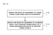
- FIG. 7A and FIG. 7B are flowcharts showing the sequence of searching for a route for moving a material according to an embodiment of the invention.
- FIG. 8 shows the screen of the display according to an embodiment of the invention
- FIG. 9 shows an example of switchover between a first display mode and a second display mode according to an embodiment of the invention.
- FIG. 10 shows an example of exchanging the positions of the divided screen areas of the display according to an embodiment of the invention
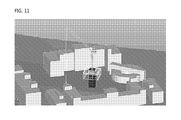
- FIG. 11 shows a 3D side view of the tower crane and the surrounding structures according to an embodiment of the invention.
- FIG. 12 shows the screen of the display for making visible or invisible the surrounding structures
- FIG. 13A shows an example in which, when the tower crane horizontally rotates, the surrounding structures are rendered as rotating while the tower crane is fixed on the screen, according to an embodiment of the invention (first rotation mode image);
- FIG. 13B shows an example in which, when the tower crane horizontally rotates, the tower crane is rendered as rotating while the surrounding structures are fixed on the screen, according to another embodiment of the invention (second rotation mode image);
- FIG. 14 is an imaginary view showing an example in which the display is realized using a head-up display (HUD) scheme according to an embodiment of the invention.
- HUD head-up display
- FIG. 15 shows an example of an image rendered on the screen of the display using the augmented reality technology according to an embodiment of the invention.
- first, second, A and B can be used in describing various elements, it should be understood that these terms do not limit those elements but merely discriminate those elements from others. For instance, first element can be named the second element, and vice versa, without departing the scope of protection of the present invention.
- the term “and/or” shall include the combination of a plurality of listed items or any of the plurality of listed items.
- constituent elements of the present invention are merely distinguished according to their main functions. Specifically, two or more constituent elements that will be described later may be combined into one constituent element, or one constituent element may be divided into two or more constituent elements having more specified functions. Each constituent element that will be described later may additionally carry out some or all of the functions of another constituent element in addition to its main function, or some of the main functions of one constituent element may be carried out exclusively by another constituent element. Therefore, the presence of the constituent elements which will be described herein should be interpreted based on their functions.
- the configuration of the constituent elements of the tower crane navigation system according to the present invention may be different from FIG. 1 as long as they can realize the object of the present invention.
- FIG. 1 is a block diagram schematically showing the configuration of the tower crane navigation system according to an embodiment of the invention.
- the tower crane navigation system includes a material position information measuring section 100 for measuring the position of a material which is being lifted up by a tower crane; a structure information measuring section 200 for measuring position information about structures within and/or beyond the working radius of the tower crane; a route searching section 400 for searching for a route of movement of the material to be lifted up from a departure to a destination; a route storage 450 in which the routes of movement determined by the route searching section 400 are stored with respect to the tower cranes; a data processing section 300 for receiving data from the material position information measuring section 100 and data from the structure information measuring section 200 , and for calculating two-dimensional (2D) or three-dimensional (3D) image data indicating relative positional information with respect to the tower crane, the material lifted up by the tower crane and the surrounding structures; and a display unit 700 for displaying information of at least one selected from among the tower crane, the material lifted up by the tower crane and the surrounding structures using the image data produced by the data processing section 300 , and for displaying the route of movement searched for by the route searching
- the material position information measuring section 100 is a component which locates the material which is to be lifted up by a material hoist of the tower crane. It is preferred that the material hoist of the tower crane be implemented as a hook or the like.
- the material position information measuring section 100 includes at least one selected from among a global positioning system (GPS) device 150 , a camera 160 , a laser sensor 110 , an angle sensor 130 , a slewing sensor 140 , a load cell 170 and an encoder sensor 120 , installed on the tower crane.
- GPS global positioning system
- the structure information measuring section 200 is a component which measures the position information pertaining to the vertical position of structures positioned within the working radius of the tower crane, and structures as well as geographical features positioned beyond the working radius of the tower crane around the working radius.
- the data processing section 300 is a device which calculates the position of the tower crane, the position of the material to be lifted up and the positions of the surrounding structures based on data received from the material position information measuring section 100 and the structure information measuring section 200 , and converts the data into a 2D or 3D image.
- the data processing section 300 includes a data receiver 310 which receives the data transmitted from the material position information measuring section 100 and the structure information measuring section 200 , a filter 320 which filters at least a part of the received data, if required, and a calculator 330 which calculates the positions of the tower crane, the material on the tower crane and the surrounding structures based on the received data and/or the filtered data.
- the data can be transmitted and/or received as wired or wireless.
- An image data of the camera 160 or data from the GPS 150 can be processed after being filtered. Filtering of the image data of the camera 160 can include, for example, changing a color, adjusting brightness, and removing an unnecessary image.
- the data from the GPS 150 can be subjected to filtering which make use of only a necessary part from among various provided data, or to filtering for integrity of a radio signal, and so on.
- the position of the tower crane, the position of the material that to be lifted up by the tower crane and the positions of the structures around the tower crane are relative positions with respect to a reference point. It is basically preferable that the relative positions be calculated with respect to the axis of rotation of a turntable of the tower crane. In this case, it is typical that the axis of rotation of the tower crane be positioned at the center of the display unit 700 .
- the position can be calculated with respect to the material that to be lifted up by the tower crane, or to a specific part of a structure that is being constructed by the tower crane. Furthermore, when a plurality of tower cranes is used, the position calculation can be processed with respect to different tower cranes.
- each tower crane When a plurality of tower cranes is disposed, the position of the material and the positions of the surrounding structures are determined with respect to each tower crane. Since it is preferable to display operation-related information to each of the tower cranes, each tower crane is preferably provided with respective elements of the material position information measuring section 100 , the structure information measuring section 200 , the route searching section 400 , and so on.
- FIG. 2 shows sensors and devices which constitute the material position information measuring section 100 of the tower crane navigation system according to an embodiment of the invention.
- the material position information measuring section 100 includes the GPS device 150 , the camera 160 , the laser sensor 110 , the angle sensor 130 , the slewing sensor 140 , and the encoder sensor 120 .
- the GPS device 150 is preferably disposed on the material hoist. Based on the satellite information, points of the tower crane and the material hoist on the map can be observable, and then it is possible to measure the distance of the material hoist from the ground. In addition, it is possible to dispose another GPS device 150 in the central portion of the tower crane in order to measure the horizontal distance from the center of the tower crane to the material hoist.
- the GPS devices 150 can be used in order to determine mutual positions of the tower cranes.
- the camera 160 be implemented as a video camera 160 which can take a video. It is preferable to take images of the surrounding environment and structures with respect to the material hoist. According to an embodiment of the invention, it is possible to dispose the video camera 160 on the jib of the tower crane in order to take images. In order to take a top-down image to the material, the camera 160 may be disposed on the part of the jib at the top of the material hoist.
- the camera 160 can be disposed on the material hoist in order to take images of the surroundings with the material or take images of the surrounding environment and structures without the material being seen. Furthermore, in this case, it is possible to take surrounding images at a variety of angles with respect to the material as well as the top down image to the material.
- the laser sensor 110 is a device which measures distances to surrounding objects using a laser range measurer. It is possible to measure the distance from the ground to the material hoist by installing the laser sensor 110 on the material hoist.
- an ultrasonic distance meter a chirp spread spectrum (CSS)-based distance meter, an impulse radio ultra-wideband (IR UWB)-based distance meter, or the like can be used.
- the distance meter can be understood as including all types of distance meters that a person having ordinary skill in the art can selectively use.
- the angle sensor 130 is a device which measures the vertical directional angle of the jib of the tower crane.
- the angle sensor 130 is disposed on the jib of the tower crane in order to measure angles, and is preferably implemented as a gyro sensor which can measure an angle with respect to the horizontal direction. Furthermore, a variety of sensors that measure an angle varying with respect to the direction of the gravity can be used.
- the angle sensor 130 can be disposed at any position of the jib, since the device can operate normally as long as installed on places where the angle changes relative to the horizon.
- the slewing sensor 140 which measures the degree of rotation of the rotary shaft of the jib with respect to the leveled position of the jib can be used to substitute the angle sensor 130 .
- the angle sensor 130 is not mounted on a tower crane (i.e., a fixed tower crane) which is configured such that the jib does not move in the horizontal direction.
- a tower crane i.e., a fixed tower crane
- the slewing sensor 140 of the tower crane serves to measure the angle of horizontal rotation of the tower crane. It is preferred that the angle of rotation be expressed as an angle with respect to true north on the map. Furthermore, the angle of rotation can be set with respect to a specific direction set by an operator.
- the slewing sensor 140 be disposed on the central axis of the turntable of the tower crane. While the slewing sensor 140 is also preferably implemented as a gyro sensor which measures the degree of rotation with respect to a specific reference, it can be implemented as any one of various types of sensors which a person having ordinary skill in the art can employ.
- the GPS device 150 as a means for substituting the slewing sensor 140 and measure at what angle the front of the tower crane is oriented with respect to the true north using a data through the GPS device 150 .
- the encoder sensor 120 is a device which measures the vertical travel distance of the material hoist (a hook).
- the material hoist is connected to the jib of the tower crane via a rope, and the length of the material hoist is adjustable. Typically, the material hoist moves up and down using a rotary motor which winds the rope and sheaves.
- the encoder sensor 120 is a device which is coupled to the motor and detects the revolution count of the motor by outputting a voltage in proportion to the revolution count and sending the output voltage to a processing circuit. It is therefore preferred that the encoder sensor 120 of the tower crane be disposed on the rotary motor which winds the rope in order to measure the vertical travel distance of the material-lifting part.
- the load cell is a device which measures the weight of the material that is lifted up.
- the load cell provides information about whether or not the weight of the material exceeds the maximum weight that can be lifted to the display unit 700 , and is also used when compensating for the influence of the wind in the process of searching for a route for moving the material which will be described later.
- FIG. 3 schematically shows objects to be measured by the sensors constituting the material position information measuring section.
- FIG. 3 shows an embodiment in which the camera 160 is disposed on the portion of the jib which is positioned vertically above the material hoist and takes a top down image.
- the laser sensor 110 , the GPS device 150 and the encoder sensor 120 participate in measuring distances of the material hoist.
- the distances with respect to the material hoist can be measured in a variety of forms, such as a distance from the ground or a distance from the vertical jib.
- the slewing sensor 140 measures the direction of rotation and the yawing angle of the central axis of the turntable of the tower crane, and the angle sensor 130 measures the pitching angle of the jib.
- the distance from the central axis of the turn table of the tower crane to the material hoist can be measured by comparing the GPS device 150 disposed in the center of the tower crane and the GPS device 150 disposed on the material hoist. Furthermore, although not shown, it is possible to measure the distance from the central axis of the turntable of the tower crane to the material hoist through the vertical travel distance (position) of the material hoist obtained using the encoder sensor 120 and the pitching angle of the jib obtained using the angle sensor 130 . In this case, the GPS device 150 on the central axis of the tower crane is not required.
- the structure information measuring section 200 is devised to measure the position information, pertaining to the vertical position of structures positioned within the working radius of the tower crane, and structures, geographical features, or so on positioned beyond the working radius of the tower crane around the working radius.
- the position data about the structures around the tower crane are basically required to indicate the shapes of the surrounding structures, and furthermore, required to determine the possibility of the tower crane or the material held by the tower crane colliding with any of the surrounding structures.
- the first factor is to use a 3D schedule data which is generated, with the passage of time, based on an original 3D design data of a structure.
- the second factor is to measure the position of an actual surrounding structure using a distance meter disposed on the tower crane. The latter case can measure not only the structure that is being constructed by the tower crane, but also the surrounding structures, the surrounding geographical features and the position of another tower crane.
- the structure information measuring section 200 includes a structure data providing section 220 which presents the position information about the structures depending on the schedules of the structures.
- the structure data providing section 220 provides the position information about the structures which are within and beyond the working radius of the tower crane.
- the structure data providing section 220 creates 3D structure data based on a structure design data stored in a design data server 210 .
- the structure data providing section 220 provides the 3D structure data, which will be updated in the course of the structure construction schedule being carried out.
- the update can be carried out in two ways by an update section 230 .
- the construction of a building is generally carried out according to a predetermined term of work. It is preferred that data based on a 3D drawing which was designed in advance be provided.
- the 3D structure data is produced by updating the design data simply according to passage of time. That is, the 3D structure data is created based on only the 3D design data which has been prepared in advance while designing the structure.
- the construction schedule is not necessarily carried out according to a timetable, it is more preferable that the 3D structure data be created by checking the structure under construction in real time. This update can be carried out in real time by photographing the structure under construction using the camera 160 which is disposed around the structure.
- the distance meter may be one of a laser distance meter, an ultrasonic distance meter, a CSS distance meter or an IR UWB distance meter.
- this is not intended to be limiting, and examples for the distance meter include any distance meters that a person having ordinary skill in the art can commonly use.
- the route searching section 400 is a component which produces the route for moving the material to be lifted up by the tower crane.
- FIG. 1 depicts the route searching section 400 as a component which searches for the route using a data sent from the data processor 300 .
- the route searching section 400 can directly receive data from the material position information measuring section 100 and the structure information measuring section 200 .
- the specification of the tower crane to be implemented is important. In other words, it is required to consider all of the height of the central axis of the turntable of the tower crane, the length of the jib of the tower crane, the ability of the jib to pitch in the vertical direction, the maximum pitching angle of rotation of the jib in the vertical direction, the maximum length of descending when the rope connected to the material hoist extends farthest, the yawing angle of horizontal rotation of the tower crane, the rotation speed of the tower crane, or so on. It is possible to inspect all of routes along which the tower crane can move by running a program (simulation) using the specification and performance of the tower crane as variables.
- FIG. 4 shows an embodiment which measures a travel distance of the material hoist of the tower crane upwardly and downwardly.
- the distance meter disposed on the material hoist or the jib can measure the distance between the material hoist of the tower crane and the structure under construction or the ground.
- FIG. 5 shows variables for measuring a yawing distance or angle of yawing caused by horizontal rotation of the turntable of the tower crane.
- the angle of yawing ⁇ of the central axis of the turntable can be measured using the slewing sensor 140 .
- FIG. 6 shows an embodiment which measures a pitching distance or an angle of pitching according to the pitching rotation of the jib of the tower crane.
- the pitching distance or the angle of pitching can be measured using the angle sensor 130 on the rotary shaft connected to the body of the tower crane.
- the pitching distance according the pitching of the corresponding portion can be measured simply when the length of the corresponding portion is measured.
- start point and destination be inputted in advance using a keypad, a keyboard, a mouse or a touchscreen before the tower crane moves. That is, the operator checks the start point and destination on the screen and selects them before moving the material.
- FIG. 7A and FIG. 7B are flowcharts showing the sequence of searching for a route for moving a material according to embodiments of the invention.
- the start point and/or destination can be set by a variety of methods, basically, the operator can set the start point and/or destination.
- the route for moving the material can be calculated based on information about the surroundings of the tower crane.
- the route of movement can be calculated based on the maneuverable zone within which the tower crane can move, position information about the surrounding structures, present position information of the material, or so on.
- the maneuverable zone differs depending on the specification of each tower crane. As will be described later, the route of movement can be produced in accordance with a variety of standards.
- the tower crane navigation system can integrally manage the whole tower cranes. It is preferred, however, that the process of searching for the routes of movement be carried out with respect to each tower crane, since the start points and the destinations of the tower cranes are separately set rather than being set simultaneously.
- the routes for movement searched for the tower cranes may have an overlapped path between them.
- the worst case is that the tower cranes collide with each other while each moving along the searched routes. Therefore, when two or more cranes have overlapped paths, an apparatus or method for avoiding the collision between the tower cranes is required.
- the route searching section 400 searches for the routes for the tower cranes.
- the routes for movement of the tower cranes overlap each other, the routes must be re-set in order not to overlap each other.
- a route of movement of another tower crane B is preferably searched from among routes that do not overlap the route stored in the route storage 450 .
- a shortest route of movement of one tower crane A is searched for, and is inspected whether or not it overlaps a route of movement for another tower crane B.
- a new route of movement of the tower crane B can be searched for.
- a storage medium such as a server, to which the route searching section 400 of any of tower cranes can access.
- a storage medium to which one route searching section 400 can access as wired or wireless, is used.
- the route of the present tower crane must be searched for in consideration of all routes stored in the route storage 450 .
- the routes of two or more tower cranes are to be re-set, the possibility of collision must be considered.
- the speed of work across the entire construction site is considered.
- route stored in the route storage 450 be deleted when the corresponding tower crane has moved to the destination.
- the tower crane navigation system can also include a control section 600 which controls the tower cranes using the data of the material position information measuring section 100 , the structure information measuring section 200 and the route searching section 400 . Furthermore, when two or more tower cranes are operating and the routes of the tower cranes determined by the route searching section 400 overlap each other, the control section 600 can control the tower cranes having the overlapping paths so that they move along the overlapping paths at different time slots.
- a time slot during which each tower crane passes through a specific area It can be determined based on a variety of factors, among which the most important is a time at which the material is completely loaded by the material hoist.
- the time when the material is loaded by the material hoist can be determined by analyzing an image of the camera 160 which is disposed on or around the hook. That is, it is possible to determine the time at which the material is completely loaded based on the amount of remaining material to be loaded or whether the material needs much time to load or not. Or, if the operator set loading time in advance, the time may be determined using the set loading time.
- the speeds of moving the tower crane upwardly, downwardly and laterally may differ depending on the handling of the operator, it is preferable to determine at which time the tower crane passes through the overlapping paths, based on an average speed of movement while carrying out the task. It is preferred that the tower crane be controlled such that it has a sufficient and safe time interval because time differences may be caused by the handling of the operator.
- the route of movement of the tower crane A may not be utilized as grounds to determine whether it is over the overlapping paths or not, for the process of searching for the route of movement of another tower crane B.
- start point and destination it is possible to select a point where the operator of the tower crane actually loaded the material as a basic start point and a point at which the material actually arrives as a basic destination. That is, the operator does not independently set the start point and the destination, but the start point and the destination are set depending on contents of a task. This is because the processes of moving materials frequently have the same start point and the same destination for a predetermined time.
- the process of searching for the route according to the invention can take a variety of modes.
- the route search mode can be implemented as one selected from among a safety first mode, a productivity first mode and a previous route mode.
- the safety first mode preferably selects one route of movement from among routes of movement along which the tower crane can move without colliding with any structure between the start point and the destination, in particular, the route of movement in which the distance between the tower crane and the structure is greatest.
- the safety first mode is the route of movement for which the possibility of the tower crane colliding with any structure is lowest.
- the productivity first mode preferably selects the shortest route of movement from among routes of movement along which the tower crane can move without colliding with any structure between the start point and the destination.
- the distance between the tower crane and the structure must be equal to or greater than a predetermined reference distance even though the shortest route of movement is selected.
- a predetermined reference distance can be selectively inputted by the operator, the reference distance can be considered safe when securing at least several meters.
- the previous route mode preferably selects a route of movement that is the same as the previous route of movement along which the tower crane moved previously.
- the previous route which was proven to be a route along which the material was successfully moved without a collision, is provided.
- the previous route can be one selected from among a plurality of routes, along which the materials of the tower crane were moved without a collision, according to a combination of the start point and the destination.
- the routes are stored in the route searching section 400 , such that the operator can select one route from among the stored routes.
- the route of movement of the material of the tower crane selected from among the various modes be compensated for in consideration of positional displacements of the material which are calculated from variables, including the direction and speed of the wind which are measured in real time and the weight of the material which is lifted up by the tower crane.
- the direction and speed of the wind can be referred to as factors that must be considered for safe operation of the tower crane. According to physics, when the direction and speed of the wind and the weight of the material (precisely, the material and the material hoist) which is moved by the tower crane are measured, a displacement affecting the route of movement of the material can be calculated.
- the speed and direction of the wind can be utilized when receiving externally observed data, or the tower crane can be provided with a sensor which measures the speed and direction of the wind.
- the weight of the material is measured using the load cell as described above.
- the tower crane navigation system capable of searching for the route of movement of the material according to the invention can also include an alarming section 500 which generates a route deviation alarm when a route along which the material is moved by the tower crane deviates from the designated route determined by the route searching section 400 .
- the tower crane navigation system can also include an alarming section 500 which generates a collision danger alarm when the tower crane has moved closer than a reference distance in which the tower crane might collide with a structure, based on the data of the material position information measuring section 100 and the structure information measuring section 200 .
- the collision danger alarm can be generated irrespective of the function of searching for the route of movement, and the tower crane navigation system without the function of searching for the route of movement of the material can also use the alarm.
- the display unit 700 of the tower crane navigation system capable of searching for the route of movement of the material according to the invention display the content of the alarm on the screen and display a route of movement along which the tower crane is to return to the predetermined route.
- the display unit 700 of the tower crane navigation system capable of searching for the route of movement of the material according to the invention display the content of the alarm on the screen and display a returning route along which the tower crane can move while avoiding a collision.
- the route from the present point to the destination can be searched for again when selected by the operator.
- the display unit 700 can display the route determined by the route searching section 400 on at least one selected from among a side view image of the tower crane and the surrounding structures, a top down view image of the tower crane and the structures and a top down view image of the material taken by the camera 160 disposed on the tower crane.
- the route of movement of the material displayed on the image of the display unit 700 can be marked with a 2D or 3D solid line so that the operator can easily see it from the screen image.
- the display unit 700 can display direction pointers which help move along the route determined by the route searching section 400 on at least one selected from among a side view image of the tower crane and the structures, a top down view image of the tower crane and the structures and a top down view image of the material that is provided by the camera 160 disposed on the tower crane.
- 2D or 3D arrows or notices are displayed on the image of the display unit 700 in order to present the route in real time.
- the searched route of movement of the material can be expressed by numerical values. It is possible to indicate how many meters the tower crane must move or at what degrees of angle the tower crane must rotate while pointing in the upward, downward, left or right direction. In addition, it is possible to indicate for how many seconds the tower crane must move so that the operator can easily perceive. Furthermore, such guidance can be provided not only with indications on the screen but also with voices.
- the control section 600 can control the material hoist of the tower crane to automatically move the material from the start point to the destination along the route determined by the route-searching section 400 and then to return to the start point along the searched route. That is, the tower crane is controlled so that it automatically moves along the searched route. Even if the tower crane is automatically operating, the operation can be converted into manual mode by the selection of the operator.
- control section 600 can stop the operation of the tower crane when the tower crane does not return to the indicated returning route after the collision danger alarm was generated.
- the tower crane operator can easily check the area, which was not easy to check by eye from within the cabin, and easily recognize the circumstances with regard to the movement of the tower crane. Therefore, the image of the material of the tower crane and the surrounding structures must be provided according to the situation of the operator.
- the present invention provides a variety of display techniques.
- FIG. 8 shows the screen of the display unit 700 according to an embodiment of the invention.
- the display unit 700 according to the invention can operate in a first display mode in which at least two images selected from among a side view image of the tower crane and the surrounding structures, a top down view image of the tower crane and the surrounding structures and a top down view image of the material, that is provided by the camera 160 disposed on the tower crane, are presented in divided areas.
- the display unit 700 can operate in a second display mode in which one image selected from among the side view image of the tower crane and the structures, the top down view image of the tower crane and the structures and the top down view image of the material, that is provided by the camera 160 disposed on the tower crane, is presented on one full screen.
- the first display mode and the second display mode can be switched in response to an input of the user.
- an input means of the user may be implemented as one selected from among a variety of input means, including a keyboard, a keypad, a mouse, a joystick, buttons, a touch screen and so on.
- the sizes of the divided areas in which the side view image of the tower crane and the surrounding structures, the top down view image of the tower crane and the surrounding structures or the top down view image of the material that is provided by the camera 160 disposed on the tower crane is realized can be adjusted.
- the positions of the divided areas, in which the side view image of the tower crane and the structures, the top down view image of the tower crane and the structures or the top down view image of the material that is provided by the camera 160 disposed on the tower crane are displayed, can be exchanged with each other.
- the conversion between the first display mode and the second display mode, the adjustment of the sizes of the divided image areas in the first display mode, or the exchange of the mutual positions of the divided image areas be conducted by an input of the user.
- the screen can be automatically converted or changed into a screen that is mostly necessary for the operation of the tower crane.
- At least one selected from among the side view image of the tower crane and the surrounding structures, the top down view image of the tower crane and the surrounding structures and the top down view image of the material, that is provided by the camera 160 disposed on the tower crane be indicated with at least one piece of information selected from among the angle of yawing of the tower crane, the angle of pitching of the jib, the length of the jib, the height of the material hoist, the vertical distance from the jib to the material hoist, and the weight of the jib that is lifted up.
- the indicated information can be selected by the operator, or the tower crane system can automatically indicate a piece of information necessary for the present operation. Otherwise, it is possible to display the most necessary information at present with a different color, with a thick style of type, or by flickering letters so that the information is noticeable.
- the side view image of the tower crane and the structures can be displayed in a 2D or 3D image.
- the 3D image can be expressed by a perspective view image which is observed at a predetermined reference angle.
- FIG. 11 shows a 3D side image of the tower crane and the surrounding structures according to an embodiment of the invention.
- the reference angle at which the perspective view is formed ranges from 0° to 90° when the horizon is regarded as 0°. An angle ranging from about 30° to about 45° is preferable. This angle of inclination may be changed due to an input of the operator.
- the 2D image is simple, and it is easy to intuitively recognize the 2D image.
- the 3D image makes it easy to locate an actual structure. In some cases of the 3D image, however, parts of the tower crane may be concealed or be displayed in a manner in which they are not easily recognized depending on the position of the structure and the direction and angle of yawing rotation of the tower crane.
- the display of the image of each structure in the side view image of the tower crane and the surrounding structures or the top down view image of the tower crane and the surrounding structures, the display of the image of each structure can be selected omitted and only the outline of each structure can be marked with dotted lines.
- FIG. 12 shows the screen of the display unit 700 on which a surrounding structure is displayed or hidden.
- the top down view image of the tower crane and the surrounding structures can be displayed using a 2D image which is expressed with contour lines such that the heights of the tower crane and the structures can be identified.
- the contour lines can be marked with different colors depending on the structures, the tower crane and the surrounding geographical features, with different colors depending on heights, using different thicknesses of lines depending on heights, or using a combination thereof.
- the side view image of the tower crane and the surrounding structures or the top down view image of the tower crane and the surrounding structures can be displayed as a first rotation mode image in which the tower crane is fixed but the surrounding structures rotate, as shown in FIG. 13A .
- the side view image of the tower crane and the surrounding structures or the top down view image of the tower crane and the surrounding structures can be displayed as a second rotation mode image in which the surrounding structures are fixed but the tower crane rotates. Furthermore, the first rotation mode image and the second rotation mode image can be switched over each other in an automatic process or due to an input of the user.
- FIG. 14 is a forecast view showing an example in which the display unit 700 is implemented using a head-up display (HUD) scheme according to an embodiment of the invention.
- FIG. 14 provides a view seen from inside of the cabin.
- HUD head-up display
- the display unit 700 can display at least one selected from among the route determined by the route searching section 400 , the direction in which the tower crane moves, the speed at which the tower crane moves, and the information about the structures in the HUD scheme. It is preferable that the HUD be realized through a window disposed in the cabin of the tower crane. Referring to FIG. 14 , the direction of rotation and the level of speed (speed 1 ) of the tower crane are displayed on the top left, a route along which the material is to be moved is marked around the center, and the final destination is marked with imaginary lines. In the right part of FIG. 15 , a typical display device is disposed.
- FIG. 15 shows an example of an image which is displayed on the screen of the display unit 700 using the augmented reality technology according to an embodiment of the invention.
- the left part of the screen of FIG. 15 displays an image of the side shape of the tower crane, which is taken using an actual camera instead of being virtually expressed in graphics. This provides a more accurate shape of movement of the tower crane to the operator.
- the information about the structures (building A and building B) surrounding the tower crane is marked, so that the operator can intuitively match the display screen with the surrounding background which he/she can see from the cabin. Accordingly, the operator can more rapidly inspect the movement of the tower crane, the direction of movement of the tower crane, or so on.
Landscapes
- Engineering & Computer Science (AREA)
- Radar, Positioning & Navigation (AREA)
- Remote Sensing (AREA)
- Physics & Mathematics (AREA)
- Mechanical Engineering (AREA)
- General Physics & Mathematics (AREA)
- Automation & Control Theory (AREA)
- Electromagnetism (AREA)
- Computer Networks & Wireless Communication (AREA)
- Control And Safety Of Cranes (AREA)
Applications Claiming Priority (7)
| Application Number | Priority Date | Filing Date | Title |
|---|---|---|---|
| KR1020100053341A KR101192509B1 (ko) | 2010-06-07 | 2010-06-07 | 타워크레인 네비게이션 장치 |
| KR1020100053341 | 2010-06-07 | ||
| KR10-2010-0053341 | 2010-06-07 | ||
| KR1020110034570A KR101243455B1 (ko) | 2011-04-14 | 2011-04-14 | 타워크레인 네비게이션 시스템 |
| KR10-2011-0034570 | 2011-04-14 | ||
| KR1020110034570 | 2011-04-14 | ||
| PCT/KR2011/004141 WO2011155749A2 (ko) | 2010-06-07 | 2011-06-07 | 타워크레인 네비게이션 시스템 |
Publications (2)
| Publication Number | Publication Date |
|---|---|
| US20130345857A1 US20130345857A1 (en) | 2013-12-26 |
| US8909467B2 true US8909467B2 (en) | 2014-12-09 |
Family
ID=45098518
Family Applications (1)
| Application Number | Title | Priority Date | Filing Date |
|---|---|---|---|
| US13/995,286 Active 2032-02-21 US8909467B2 (en) | 2010-06-07 | 2011-06-07 | Tower crane navigation system |
Country Status (2)
| Country | Link |
|---|---|
| US (1) | US8909467B2 (ko) |
| WO (1) | WO2011155749A2 (ko) |
Cited By (13)
| Publication number | Priority date | Publication date | Assignee | Title |
|---|---|---|---|---|
| US20140031954A1 (en) * | 2012-07-24 | 2014-01-30 | Bomag Gmbh | Operating unit for a construction machine and method for operating the operating unit |
| CN109467010A (zh) * | 2017-09-07 | 2019-03-15 | 利勃海尔爱茵根有限公司 | 用于借助起重机移动负载的方法 |
| JP2019112178A (ja) * | 2017-12-22 | 2019-07-11 | 戸田建設株式会社 | タワークレーンの自動運転システム |
| JP2019172410A (ja) * | 2018-03-27 | 2019-10-10 | 株式会社タダノ | クレーン |
| JP2020132310A (ja) * | 2019-02-14 | 2020-08-31 | 株式会社タダノ | クレーン及び経路生成システム |
| JP2020132312A (ja) * | 2019-02-14 | 2020-08-31 | 株式会社タダノ | クレーンおよびクレーンの経路生成システム |
| JP2020132313A (ja) * | 2019-02-14 | 2020-08-31 | 株式会社タダノ | クレーンおよびクレーンの経路生成システム |
| JP2020132314A (ja) * | 2019-02-14 | 2020-08-31 | 株式会社タダノ | クレーンおよびクレーンの経路生成システム |
| JP2020132315A (ja) * | 2019-02-14 | 2020-08-31 | 株式会社タダノ | クレーンおよびクレーンの経路生成システム |
| JP2020132316A (ja) * | 2019-02-14 | 2020-08-31 | 株式会社タダノ | クレーン及び経路生成システム |
| JP2020140697A (ja) * | 2019-02-28 | 2020-09-03 | ベイジン バイドゥ ネットコム サイエンス アンド テクノロジー カンパニー リミテッド | 建設機械設備の回転角度を確定するための方法および装置 |
| EP3795528B1 (en) | 2019-09-23 | 2023-12-13 | FASSI GRU S.p.A. | Device for remotely commanding a crane mounted to a truck and for moving said truck, system and method |
| US12054361B2 (en) * | 2016-12-20 | 2024-08-06 | Konescranes Global Oy | Method, computer program and equipment for controlling crane and method for updating crane |
Families Citing this family (61)
| Publication number | Priority date | Publication date | Assignee | Title |
|---|---|---|---|---|
| JP5876679B2 (ja) * | 2011-07-08 | 2016-03-02 | 株式会社タダノ | 性能線表示装置 |
| MY168361A (en) * | 2012-06-01 | 2018-10-31 | Seatrax Inc | In the united states patent and trademark office |
| DE202012012116U1 (de) * | 2012-12-17 | 2014-03-19 | Liebherr-Components Biberach Gmbh | Turmdrehkran |
| CN103395694B (zh) * | 2013-08-13 | 2015-04-08 | 哈尔滨东建机械制造有限公司 | 塔式起重机一体化监控系统 |
| AT14237U1 (de) | 2014-01-31 | 2015-06-15 | Palfinger Ag | Kransteuerung |
| CN104003307B (zh) * | 2014-04-11 | 2016-02-03 | 湖南中联重科智能技术有限公司 | 塔机视频监控控制设备、方法、系统及塔机 |
| US10503249B2 (en) * | 2014-07-03 | 2019-12-10 | Topcon Positioning Systems, Inc. | Method and apparatus for construction machine visualization |
| JP6539984B2 (ja) * | 2014-10-31 | 2019-07-10 | 株式会社タダノ | ブーム姿勢検出装置 |
| CN104528557A (zh) * | 2014-11-19 | 2015-04-22 | 成都嵌智捷科技有限公司 | 方便测量风速的塔机防碰撞机 |
| CN104609322A (zh) * | 2014-11-19 | 2015-05-13 | 成都嵌智捷科技有限公司 | 改进型塔机防碰撞终端 |
| CN104477801A (zh) * | 2014-11-19 | 2015-04-01 | 成都嵌智捷科技有限公司 | 塔机不易发生碰撞的装置 |
| JP6306552B2 (ja) * | 2015-10-13 | 2018-04-04 | 株式会社タダノ | 遠隔操作装置、及び案内システム |
| CN105318856A (zh) * | 2015-11-18 | 2016-02-10 | 北京科技大学 | 一种基于触摸屏的角度传感器显示装置 |
| DE102015016848A1 (de) * | 2015-12-23 | 2017-06-29 | Liebherr-Werk Biberach Gmbh | System zur zentralen Steuerung von ein oder mehreren Kranen |
| DE102016000353A1 (de) * | 2016-01-14 | 2017-07-20 | Liebherr-Components Biberach Gmbh | Kran-, Baumaschinen- oder Flurförderzeug-Simulator |
| JP7180966B2 (ja) | 2016-01-29 | 2022-11-30 | マニタウォック クレイン カンパニーズ, エルエルシー | 視覚的アウトリガー監視システム |
| DE102016001684A1 (de) * | 2016-02-12 | 2017-08-17 | Liebherr-Werk Biberach Gmbh | Verfahren zur Überwachung wenigstens eines Krans |
| DE102016004266A1 (de) | 2016-04-08 | 2017-10-12 | Liebherr-Werk Biberach Gmbh | Baumaschine, insbesondere Kran, und Verfahren zu deren Steuerung |
| WO2017174196A1 (de) | 2016-04-08 | 2017-10-12 | Liebherr-Components Biberach Gmbh | Kran |
| DE102016004382A1 (de) * | 2016-04-08 | 2017-10-12 | Liebherr-Werk Biberach Gmbh | Verfahren und Vorrichtung zum Planen und/oder Steuern und/oder Simulieren des Betriebs einer Baumaschine |
| US9914624B2 (en) * | 2016-06-22 | 2018-03-13 | The Boeing Company | Systems and methods for object guidance and collision avoidance |
| JP6729146B2 (ja) * | 2016-08-03 | 2020-07-22 | コベルコ建機株式会社 | 障害物検出装置 |
| CN106365057B (zh) * | 2016-11-19 | 2017-09-15 | 青岛蓝天创先科技服务有限公司 | 一种塔式起重机力矩监测报警装置 |
| US11124392B2 (en) | 2016-11-22 | 2021-09-21 | Manitowoc Crane Companies, Llc | Optical detection and analysis for boom angles on a crane |
| KR102449834B1 (ko) * | 2017-02-17 | 2022-09-29 | 스미도모쥬기가이고교 가부시키가이샤 | 작업기계용 주변감시 시스템 |
| KR102320473B1 (ko) * | 2017-02-28 | 2021-11-03 | 제이. 레이 맥더모트 에스.에이. | 타겟 추적 도움을 가지고 하는 오프쇼어 선박-대-선박 리프팅 |
| CN106946159B (zh) * | 2017-03-30 | 2018-09-21 | 武汉大学 | 一种基于北斗/gps精确定位的建筑塔吊自动运行系统及控制方法 |
| SE541180C2 (en) * | 2017-04-03 | 2019-04-23 | Cargotec Patenter Ab | Driver assistance system for a vehicle provided with a crane using 3D representations |
| CN107265298A (zh) * | 2017-06-16 | 2017-10-20 | 荆门创佳机械科技有限公司 | 一种自动寻找盲区吊位的塔吊设备 |
| CN107352401A (zh) * | 2017-07-10 | 2017-11-17 | 荆门创佳机械科技有限公司 | 能自动寻找盲区吊位及监测塔身垂直度的塔吊监控系统 |
| JP7035411B2 (ja) * | 2017-09-27 | 2022-03-15 | 株式会社大林組 | クレーン操縦支援装置 |
| EP3461783B1 (de) * | 2017-09-29 | 2019-11-13 | B&R Industrial Automation GmbH | Hebeeinrichtung und verfahren zum steuern einer hebeeinrichtung |
| JP7059605B2 (ja) * | 2017-12-08 | 2022-04-26 | 富士電機株式会社 | クレーンの運転制御装置 |
| FR3074761B1 (fr) | 2017-12-11 | 2020-11-13 | Manitou Bf | Dispositif d'assistance a la manutention de charge pour vehicule et vehicule correspondant |
| JP7091729B2 (ja) * | 2018-03-09 | 2022-06-28 | 株式会社タダノ | 遠隔操作端末および遠隔操作端末を備える作業車両 |
| EP3594168A1 (de) * | 2018-07-13 | 2020-01-15 | EPSILON Kran GmbH. | Kransteuerung mit visualisierungsvorrichtung |
| US12358763B2 (en) | 2018-11-07 | 2025-07-15 | Manitowoc Crane Companies, Llc | System for determining crane status using optical and/or electromagnetic sensors |
| CN109095356B (zh) | 2018-11-07 | 2024-03-01 | 江苏徐工国重实验室科技有限公司 | 工程机械及其作业空间动态防碰撞方法、装置和系统 |
| DE102018129227A1 (de) * | 2018-11-20 | 2020-05-20 | Liebherr-Werk Biberach Gmbh | Kran mit einer Antikollisionseinrichtung sowie Verfahren zum Einrichten einer solchen Antikollisionseinrichtung |
| CN109552997B (zh) * | 2018-11-30 | 2020-01-10 | 中交第三航务工程局有限公司 | 水下栅栏板制备、定位安装方法及其安装系统 |
| CN109726514B (zh) * | 2019-01-29 | 2023-03-24 | 上海电力设计院有限公司 | 塔式光热圆筒形吸热塔自振周期的计算方法 |
| US12054363B2 (en) | 2019-02-05 | 2024-08-06 | J. Ray McDermott | System and methods for determining relative position and relative motion of objects |
| JP7151532B2 (ja) * | 2019-02-14 | 2022-10-12 | 株式会社タダノ | クレーンおよびクレーンの経路生成システム |
| KR102911293B1 (ko) * | 2019-03-30 | 2026-01-09 | 스미토모 겐키 가부시키가이샤 | 쇼벨 및 시공시스템 |
| JP7379866B2 (ja) * | 2019-05-21 | 2023-11-15 | コベルコ建機株式会社 | 作業機械 |
| CN110282552B (zh) * | 2019-07-04 | 2020-09-25 | 武汉般若易修工业技术服务有限公司 | 天车预警系统 |
| CN111017726B (zh) * | 2019-11-19 | 2020-08-21 | 中联重科股份有限公司 | 起重机吊钩定位方法、装置、系统及工程机械 |
| EP3839675B8 (en) * | 2019-12-20 | 2024-09-04 | Hiab AB | Crane control system, a vehicle, and a method in relation to the system |
| JP2021147139A (ja) * | 2020-03-18 | 2021-09-27 | 戸田建設株式会社 | タワークレーンの自動経路設定システム |
| WO2021229576A2 (en) | 2020-05-14 | 2021-11-18 | Ultrawis Ltd. | Systems and methods for remote control and automation of a tower crane |
| US20230348237A1 (en) * | 2020-07-07 | 2023-11-02 | AMLAB Pty Ltd, | Mapping of a Crane Spreader and a Crane Spreader Target |
| WO2022143193A1 (zh) * | 2020-12-31 | 2022-07-07 | 广州市建筑科学研究院集团有限公司 | 一种塔机自动吊运方法 |
| KR20240007160A (ko) * | 2021-04-12 | 2024-01-16 | 스트럭처럴 서비시스, 인크. | 크레인 오퍼레이터를 지원하기 위한 시스템 및 방법 |
| CN113911917B (zh) * | 2021-09-13 | 2023-06-02 | 杭州大杰智能传动科技有限公司 | 用于智能塔吊总控室的辅助远程操控方法 |
| CN113759853B (zh) * | 2021-09-18 | 2023-07-18 | 法兰泰克重工股份有限公司 | 一种物料自动搬运控制系统 |
| CN113928982B (zh) * | 2021-09-18 | 2022-11-18 | 法兰泰克重工股份有限公司 | 一种带雷达反馈的高精度抓斗抓取位置控制方法 |
| DE102021130785A1 (de) | 2021-11-24 | 2023-05-25 | Liebherr-Werk Biberach Gmbh | Kran |
| JP7736538B2 (ja) * | 2021-11-29 | 2025-09-09 | 清水建設株式会社 | クレーン揚重モニタリングシステム、クレーン揚重モニタリング方法およびプログラム |
| CN114706344A (zh) * | 2022-02-19 | 2022-07-05 | 山东港口渤海湾港集团有限公司 | 一种基于自动化门机协同作业的安全避让方法 |
| CN114623820B (zh) * | 2022-03-25 | 2024-07-19 | 中国华能集团有限公司 | 吊车精确定位及深度测量方法及系统 |
| EP4368558A1 (de) * | 2022-11-10 | 2024-05-15 | XCMG European Research Center GmbH | Verfahren zur steuerung der position eines lastelementes und/oder einer von einem lastelement gehaltenen last eines krans |
Citations (7)
| Publication number | Priority date | Publication date | Assignee | Title |
|---|---|---|---|---|
| JPH0717684A (ja) * | 1993-07-05 | 1995-01-20 | Kajima Corp | タワークレーンの衝突防止方法 |
| JP2005029338A (ja) | 2003-07-11 | 2005-02-03 | Ohbayashi Corp | 建設機械の動作監視システム及び方法 |
| JP2007015842A (ja) | 2005-07-11 | 2007-01-25 | Fukada Salvage & Marine Works Co Ltd | 大型構造物の運搬制御システム |
| KR20070112316A (ko) | 2006-05-20 | 2007-11-23 | 동아대학교 산학협력단 | 트랜스퍼 크레인의 무인화를 위한 자동 랜딩 방법 |
| KR20090072330A (ko) | 2007-12-28 | 2009-07-02 | 울산대학교 산학협력단 | 크레인 충돌 예측 방법 |
| US20100070179A1 (en) * | 2008-09-17 | 2010-03-18 | Cameron John F | Providing an autonomous position of a point of interest to a lifting device to avoid collision |
| KR20120008369A (ko) | 2010-07-16 | 2012-01-30 | 주식회사 에스앤에스레볼루션 | 액체 상태 측정 센서 및 이의 제조 방법 |
-
2011
- 2011-06-07 US US13/995,286 patent/US8909467B2/en active Active
- 2011-06-07 WO PCT/KR2011/004141 patent/WO2011155749A2/ko not_active Ceased
Patent Citations (7)
| Publication number | Priority date | Publication date | Assignee | Title |
|---|---|---|---|---|
| JPH0717684A (ja) * | 1993-07-05 | 1995-01-20 | Kajima Corp | タワークレーンの衝突防止方法 |
| JP2005029338A (ja) | 2003-07-11 | 2005-02-03 | Ohbayashi Corp | 建設機械の動作監視システム及び方法 |
| JP2007015842A (ja) | 2005-07-11 | 2007-01-25 | Fukada Salvage & Marine Works Co Ltd | 大型構造物の運搬制御システム |
| KR20070112316A (ko) | 2006-05-20 | 2007-11-23 | 동아대학교 산학협력단 | 트랜스퍼 크레인의 무인화를 위한 자동 랜딩 방법 |
| KR20090072330A (ko) | 2007-12-28 | 2009-07-02 | 울산대학교 산학협력단 | 크레인 충돌 예측 방법 |
| US20100070179A1 (en) * | 2008-09-17 | 2010-03-18 | Cameron John F | Providing an autonomous position of a point of interest to a lifting device to avoid collision |
| KR20120008369A (ko) | 2010-07-16 | 2012-01-30 | 주식회사 에스앤에스레볼루션 | 액체 상태 측정 센서 및 이의 제조 방법 |
Cited By (20)
| Publication number | Priority date | Publication date | Assignee | Title |
|---|---|---|---|---|
| US20140031954A1 (en) * | 2012-07-24 | 2014-01-30 | Bomag Gmbh | Operating unit for a construction machine and method for operating the operating unit |
| US12054361B2 (en) * | 2016-12-20 | 2024-08-06 | Konescranes Global Oy | Method, computer program and equipment for controlling crane and method for updating crane |
| CN109467010A (zh) * | 2017-09-07 | 2019-03-15 | 利勃海尔爱茵根有限公司 | 用于借助起重机移动负载的方法 |
| US20190084808A1 (en) * | 2017-09-07 | 2019-03-21 | Liebherr-Werk Ehingen Gmbh | Method of moving a load usinsg a crane |
| CN109467010B (zh) * | 2017-09-07 | 2022-06-24 | 利勃海尔爱茵根有限公司 | 用于借助起重机移动负载的方法 |
| US11242228B2 (en) * | 2017-09-07 | 2022-02-08 | Liebherr-Werk Ehingen Gmbh | Method of moving a load using a crane |
| JP2019112178A (ja) * | 2017-12-22 | 2019-07-11 | 戸田建設株式会社 | タワークレーンの自動運転システム |
| JP7006442B2 (ja) | 2018-03-27 | 2022-01-24 | 株式会社タダノ | クレーン |
| JP2019172410A (ja) * | 2018-03-27 | 2019-10-10 | 株式会社タダノ | クレーン |
| JP2020132310A (ja) * | 2019-02-14 | 2020-08-31 | 株式会社タダノ | クレーン及び経路生成システム |
| JP2020132316A (ja) * | 2019-02-14 | 2020-08-31 | 株式会社タダノ | クレーン及び経路生成システム |
| JP2020132315A (ja) * | 2019-02-14 | 2020-08-31 | 株式会社タダノ | クレーンおよびクレーンの経路生成システム |
| JP2020132314A (ja) * | 2019-02-14 | 2020-08-31 | 株式会社タダノ | クレーンおよびクレーンの経路生成システム |
| JP2020132313A (ja) * | 2019-02-14 | 2020-08-31 | 株式会社タダノ | クレーンおよびクレーンの経路生成システム |
| JP7243260B2 (ja) | 2019-02-14 | 2023-03-22 | 株式会社タダノ | クレーンおよびクレーンの経路生成システム |
| JP7247634B2 (ja) | 2019-02-14 | 2023-03-29 | 株式会社タダノ | クレーンおよびクレーンの経路生成システム |
| JP2020132312A (ja) * | 2019-02-14 | 2020-08-31 | 株式会社タダノ | クレーンおよびクレーンの経路生成システム |
| JP2020140697A (ja) * | 2019-02-28 | 2020-09-03 | ベイジン バイドゥ ネットコム サイエンス アンド テクノロジー カンパニー リミテッド | 建設機械設備の回転角度を確定するための方法および装置 |
| US11182928B2 (en) | 2019-02-28 | 2021-11-23 | Beijing Baidu Netcom Science And Technology Co., Ltd. | Method and apparatus for determining rotation angle of engineering mechanical device |
| EP3795528B1 (en) | 2019-09-23 | 2023-12-13 | FASSI GRU S.p.A. | Device for remotely commanding a crane mounted to a truck and for moving said truck, system and method |
Also Published As
| Publication number | Publication date |
|---|---|
| WO2011155749A3 (ko) | 2012-03-08 |
| WO2011155749A2 (ko) | 2011-12-15 |
| US20130345857A1 (en) | 2013-12-26 |
Similar Documents
| Publication | Publication Date | Title |
|---|---|---|
| US8909467B2 (en) | Tower crane navigation system | |
| KR101192509B1 (ko) | 타워크레인 네비게이션 장치 | |
| JP5037765B2 (ja) | オペレータ誘導システム | |
| US11679961B2 (en) | Method and apparatus for controlling a crane, an excavator, a crawler-type vehicle or a similar construction machine | |
| CN111943043B (zh) | 引导信息显示装置和具备该装置的起重机、引导信息显示方法 | |
| US11216664B2 (en) | Method and device for augmenting a person's view of a mining vehicle on a mining worksite in real-time | |
| US9903715B2 (en) | Measuring system and method for marking a known target point in a coordinate system | |
| WO2017091972A1 (en) | A safety system for a machine | |
| US12134545B2 (en) | Crane inspection system and crane | |
| KR20130109232A (ko) | 자동 표현-변경 기능을 포함하는 측정 기기 | |
| CN109467010A (zh) | 用于借助起重机移动负载的方法 | |
| US12448255B2 (en) | Crane | |
| WO2019017431A1 (ja) | 測定対象物の上面推定方法、ガイド情報表示装置およびクレーン | |
| JP2014206421A (ja) | 測量システム | |
| US20230019162A1 (en) | Crane, crane body, and non-transitory computer readable medium storing program | |
| WO2019017430A1 (ja) | 測定対象物の上面推定方法、ガイド情報表示装置およびクレーン | |
| JP2023130558A (ja) | 測量支援システム、情報表示端末、測量支援方法、及び測量支援プログラム | |
| WO2019017469A1 (ja) | 地表面推定方法、ガイド情報表示装置およびクレーン | |
| JP2012225869A (ja) | 計測システム | |
| US20240310842A1 (en) | Work Machine | |
| WO2019017472A1 (ja) | ガイド情報表示装置、クレーンおよびガイド情報の生成方法 | |
| JP7760743B2 (ja) | 測量システムおよび測量方法 | |
| JP2021189663A (ja) | 巡視点検システム | |
| JP2019218198A (ja) | 操作支援システム | |
| JP2025061351A (ja) | クレーンの検査システム |
Legal Events
| Date | Code | Title | Description |
|---|---|---|---|
| AS | Assignment |
Owner name: INDUSTRY-ACADEMIC COOPERATION FOUNDATION, YONSEI U Free format text: ASSIGNMENT OF ASSIGNORS INTEREST;ASSIGNORS:LEE, GHANG;CHO, JOON BEOM;LEE, TAE KWAN;AND OTHERS;REEL/FRAME:030634/0230 Effective date: 20130605 |
|
| FEPP | Fee payment procedure |
Free format text: PAYOR NUMBER ASSIGNED (ORIGINAL EVENT CODE: ASPN); ENTITY STATUS OF PATENT OWNER: SMALL ENTITY |
|
| STCF | Information on status: patent grant |
Free format text: PATENTED CASE |
|
| MAFP | Maintenance fee payment |
Free format text: PAYMENT OF MAINTENANCE FEE, 4TH YR, SMALL ENTITY (ORIGINAL EVENT CODE: M2551) Year of fee payment: 4 |
|
| MAFP | Maintenance fee payment |
Free format text: PAYMENT OF MAINTENANCE FEE, 8TH YR, SMALL ENTITY (ORIGINAL EVENT CODE: M2552); ENTITY STATUS OF PATENT OWNER: SMALL ENTITY Year of fee payment: 8 |