EP2437237A2 - Bildverarbeitungsvorrichtung, Bildverarbeitungsverfahren und computerlesbares Speichermedium - Google Patents
Bildverarbeitungsvorrichtung, Bildverarbeitungsverfahren und computerlesbares Speichermedium Download PDFInfo
- Publication number
- EP2437237A2 EP2437237A2 EP20110182368 EP11182368A EP2437237A2 EP 2437237 A2 EP2437237 A2 EP 2437237A2 EP 20110182368 EP20110182368 EP 20110182368 EP 11182368 A EP11182368 A EP 11182368A EP 2437237 A2 EP2437237 A2 EP 2437237A2
- Authority
- EP
- European Patent Office
- Prior art keywords
- image
- dimensional model
- physical objects
- partial image
- unit
- Prior art date
- Legal status (The legal status is an assumption and is not a legal conclusion. Google has not performed a legal analysis and makes no representation as to the accuracy of the status listed.)
- Ceased
Links
Images


Classifications
-
- G—PHYSICS
- G09—EDUCATION; CRYPTOGRAPHY; DISPLAY; ADVERTISING; SEALS
- G09B—EDUCATIONAL OR DEMONSTRATION APPLIANCES; APPLIANCES FOR TEACHING, OR COMMUNICATING WITH, THE BLIND, DEAF OR MUTE; MODELS; PLANETARIA; GLOBES; MAPS; DIAGRAMS
- G09B29/00—Maps; Plans; Charts; Diagrams, e.g. route diagram
- G09B29/10—Map spot or coordinate position indicators; Map reading aids
- G09B29/106—Map spot or coordinate position indicators; Map reading aids using electronic means
-
- G—PHYSICS
- G06—COMPUTING OR CALCULATING; COUNTING
- G06T—IMAGE DATA PROCESSING OR GENERATION, IN GENERAL
- G06T13/00—Animation
- G06T13/20—Three-dimensional [3D] animation
-
- G—PHYSICS
- G06—COMPUTING OR CALCULATING; COUNTING
- G06T—IMAGE DATA PROCESSING OR GENERATION, IN GENERAL
- G06T17/00—Three-dimensional [3D] modelling for computer graphics
- G06T17/05—Geographic models
-
- G—PHYSICS
- G06—COMPUTING OR CALCULATING; COUNTING
- G06T—IMAGE DATA PROCESSING OR GENERATION, IN GENERAL
- G06T19/00—Manipulating three-dimensional [3D] models or images for computer graphics
- G06T19/006—Mixed reality
-
- G—PHYSICS
- G06—COMPUTING OR CALCULATING; COUNTING
- G06T—IMAGE DATA PROCESSING OR GENERATION, IN GENERAL
- G06T19/00—Manipulating three-dimensional [3D] models or images for computer graphics
- G06T19/20—Editing of three-dimensional [3D] images, e.g. changing shapes or colours, aligning objects or positioning parts
-
- G—PHYSICS
- G06—COMPUTING OR CALCULATING; COUNTING
- G06T—IMAGE DATA PROCESSING OR GENERATION, IN GENERAL
- G06T7/00—Image analysis
- G06T7/70—Determining position or orientation of objects or cameras
- G06T7/73—Determining position or orientation of objects or cameras using feature-based methods
- G06T7/75—Determining position or orientation of objects or cameras using feature-based methods involving models
-
- G—PHYSICS
- G09—EDUCATION; CRYPTOGRAPHY; DISPLAY; ADVERTISING; SEALS
- G09B—EDUCATIONAL OR DEMONSTRATION APPLIANCES; APPLIANCES FOR TEACHING, OR COMMUNICATING WITH, THE BLIND, DEAF OR MUTE; MODELS; PLANETARIA; GLOBES; MAPS; DIAGRAMS
- G09B29/00—Maps; Plans; Charts; Diagrams, e.g. route diagram
- G09B29/10—Map spot or coordinate position indicators; Map reading aids
- G09B29/102—Map spot or coordinate position indicators; Map reading aids using electrical means
-
- G—PHYSICS
- G09—EDUCATION; CRYPTOGRAPHY; DISPLAY; ADVERTISING; SEALS
- G09B—EDUCATIONAL OR DEMONSTRATION APPLIANCES; APPLIANCES FOR TEACHING, OR COMMUNICATING WITH, THE BLIND, DEAF OR MUTE; MODELS; PLANETARIA; GLOBES; MAPS; DIAGRAMS
- G09B29/00—Maps; Plans; Charts; Diagrams, e.g. route diagram
- G09B29/12—Relief maps
-
- G—PHYSICS
- G06—COMPUTING OR CALCULATING; COUNTING
- G06T—IMAGE DATA PROCESSING OR GENERATION, IN GENERAL
- G06T2200/00—Indexing scheme for image data processing or generation, in general
- G06T2200/08—Indexing scheme for image data processing or generation, in general involving all processing steps from image acquisition to 3D model generation
-
- G—PHYSICS
- G06—COMPUTING OR CALCULATING; COUNTING
- G06T—IMAGE DATA PROCESSING OR GENERATION, IN GENERAL
- G06T2215/00—Indexing scheme for image rendering
- G06T2215/12—Shadow map, environment map
-
- G—PHYSICS
- G06—COMPUTING OR CALCULATING; COUNTING
- G06T—IMAGE DATA PROCESSING OR GENERATION, IN GENERAL
- G06T2215/00—Indexing scheme for image rendering
- G06T2215/16—Using real world measurements to influence rendering
-
- G—PHYSICS
- G06—COMPUTING OR CALCULATING; COUNTING
- G06T—IMAGE DATA PROCESSING OR GENERATION, IN GENERAL
- G06T2219/00—Indexing scheme for manipulating 3D models or images for computer graphics
- G06T2219/20—Indexing scheme for editing of 3D models
- G06T2219/2016—Rotation, translation, scaling
Definitions
- the present invention relates to an image processing device, program, and method.
- Japanese Patent Application Laid-Open No. 2005-227590 proposes displaying a two-dimensional map and a three-dimensional image around a current location in parallel in an output image from a map guiding device.
- the viewpoint of the displayed three-dimensional image differs from the viewpoint of a user in the real space. Therefore, when the user tries to find the desired building or facility, etc. in the real space, to which he or she wants to go, a comparison of a view that the user sees in the real world around him or her and the three-dimensional image does not yield a match, and thus the user may have difficulty locating the desired building or facility, etc., easily.
- an image information processing apparatus image processing method, and computer-readable storage medium that facilitate finding an object, such as a desired building or facility, in real space.
- an apparatus for displaying physical objects comprises a capturing unit for capturing an input image of physical objects.
- the apparatus further comprises a matching unit for matching a three-dimensional model to the physical objects.
- the apparatus also comprises a processing unit for producing a modified partial image by at least one of modifying a portion of the matched three-dimensional model, or modifying a partial image extracted from the input image using the matched three-dimensional model.
- the apparatus comprises a display generator for generating signals representing an output image, the output image including the modified partial image superimposed over the input image.
- a method for displaying physical objects comprises capturing an input image of physical objects, and matching a three-dimensional model to the physical objects.
- the method further comprises producing a modified partial image by at least one of modifying a portion of the matched three-dimensional model, or modifying a partial image extracted from the input image using the matched three-dimensional model.
- the method also comprises displaying an output image including the modified partial image superimposed over the input image.
- a tangibly-embodied non-transitory computer-readable storage medium storing instructions which, when executed by a processor, cause a computer to perform a method for displaying physical objects.
- the method comprises capturing an input image of physical objects, and matching a three-dimensional model to the physical objects.
- the method further comprises producing a modified partial image by at least one of modifying a portion of the matched three-dimensional model, or modifying a partial image extracted from the input image using the matched three-dimensional model.
- the method also comprises displaying an output image including the modified partial image superimposed over the input image.
- an information processing apparatus finding an object, such as a desired building or facility in the real space, can be facilitated.
- Examples of the image processing device described herein include a personal computer (PC), a smartphone, a personal digital assistant, a digital camera, a car-mounted or handheld navigational device, or a handheld video game machine.
- PC personal computer
- smartphone a smartphone
- personal digital assistant a digital camera
- car-mounted or handheld navigational device a handheld video game machine.
- FIG. 1 is a block diagram illustrating an example of a hardware configuration of an image processing device 100 according to the present embodiment.
- the image processing device 100 includes a central processing unit (CPU) 10, a random access memory (RAM) 12, a read only memory (ROM) 14, a bus 16, a storage device 20, an imager 22, a display device 24, an input device 26, a global positioning system (GPS) module 30, an electronic compass 32, and an acceleration sensor 34.
- CPU central processing unit
- RAM random access memory
- ROM read only memory
- bus 16 a storage device 20
- an imager 22 a display device
- an input device 26 an input device 26
- GPS global positioning system
- electronic compass 32 an electronic compass 32
- acceleration sensor 34 an acceleration sensor
- the CPU 10 generally controls the operation of the image processing device 100 in accordance with programs recorded in ROM 14, storage device 20, and/or RAM 12.
- the RAM 12 temporarily stores a program and data executed by the CPU 10.
- the ROM 14 may be a nonvolatile memory for storing the program for operation of the image processing device 100.
- the bus 16 interconnects the CPU 10, RAM 12, ROM 14, storage device 20, imager 22, display device 24, input device 26, GPS module 30, electronic compass 32, and acceleration sensor 34.
- the storage device 20 includes a tangibly embodied non-transitory computer-readable storage medium, such as a hard disk or semiconductor memory, which may store programs or instructions to be executed by CPU 10.
- the storage device 20 may be non-removable or removable.
- the data stored in the storage device 20 may be dynamically obtained from an external database, when the image processing device 100 performs image processing.
- storage device 20 may be embodied in different remote devices or servers in a cloud computing configuration.
- the imager 22 is configured as a camera module with an image pickup device, such as a charge coupled device (CCD) or complementary metal oxide semiconductor (CMOS).
- the display device 24 displays an image on a screen, such as a liquid crystal display (LCD), organic light emitting diode (OLED), or plasma display panel (PDP).
- the input device 26 includes a button, keypad, touch panel, or pointing device, etc. for a user of the image processing device 100 to input information to the image processing device 100.
- the GPS module 30 receives the GPS signal transmitted from the GPS satellite to calculate an actual latitude, longitude, and altitude, etc. where the image processing device 100 is located.
- the electronic compass 32 detects the actual orientation of the images processing device 100.
- the acceleration sensor 34 detects acceleration caused by a force acting on the image processing device 100.
- FIG. 2 is a block diagram illustrating an example of a logical configuration of the image processing device 100 according to the present embodiment.
- the image processing device 100 includes an input-image obtaining unit 110, a positioning unit 120, a storage unit 130, a matching unit 140, an oscillating-movement sensing unit 150, an application unit 160, a user-interface unit 170, and an emphasizing-process unit 180.
- the term "unit" may be a software module, a hardware module, or a combination of a software module and a hardware module.
- Such hardware and software modules may be embodied in discrete circuitry, an integrated circuit, or as instructions executed by a processor.
- the input-image obtaining unit 110 i.e. capturing unit, obtains, with the imager 22, a series of input images in which the view in the real world around a user is captured. That is, an input image of a physical object, or objects, in the real world is captured. Then, the input-image obtaining unit 110 sequentially outputs the obtained input images to the matching unit 140 and emphasizing-process unit 180.
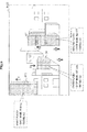
- FIG. 3 is an explanatory view illustrating an example of an input image obtained by the input-image obtaining unit 110.
- a town as the real space in which a user who carries the image processing device 100 (or a vehicle equipped with the image processing device 100, etc.) is present, appears in the input image.
- Each of such objects that appear in the input image may be a target for a geographic information search in the application unit 160 described below, or a target for which the user is guided in navigation using a navigational device.
- the positioning unit 120 determines the current location of the image processing device 100 with the GPS module 30. The positioning unit 120 also determines the actual orientation of the image processing device 100 with the electronic compass 32. The positioning unit 120 then outputs location information, such as the latitude, longitude, and attitude, and azimuth information of the image processing devise 100 obtained as a result of the measurement described above, to the matching unit 140.
- the storage unit 130 stores a three-dimensional model that describes a three-dimensional shape and a location of an object that is present in the real world.
- the object described by the three-dimensional model include an object relating to the above-mentioned application function, such as the geographic information search or navigation provided by the application unit 160.
- the three-dimensional shape and the location of objects such as a restaurant, an office, a school, a station, a communal facility, and a landmark that are present in a town, are described by the three-dimensional model.
- the three-dimensional model may be described using a language, such as Geography Markup Language (GML) or KML based on GML.
- GML Geography Markup Language
- FIG. 4 is an explanatory view for explaining an example of the three-dimensional model.
- a three-dimensional model 132 is partially depicted by way of example.
- the three-dimensional model 132 includes data on nine objects B1 to B9 that are buildings respectively.
- the three-dimensional model 132 defines, for example, an identifier of an object (hereinafter, "object lD"), a name of a building, and three-dimensional location of vertices that form the shape of the building, and the predetermined texture.
- object lD an identifier of an object
- a name of a building a name of a building
- three-dimensional location of vertices that form the shape of the building
- the predetermined texture a three-dimensional model stored by the storage unit 130 may include data on a larger number of objects (in a more widespread area) than a group of objects illustrated in FIG. 4 .
- the storage unit 130 may also store additional information, such as a rating by users for a facility, such as a restaurant
- storage unit 130 may be embodied in different remote devices or servers in a cloud computing configuration, and that the three-dimensional model may therefore be retrieved from storage unit 130 via a network in response to a remote request for a three-dimensional model from image processing device 100, instead of accessing a local storage of image processing device 100.
- the matching unit 140 associates an object included in a three-dimensional model around a current location determined by the positioning unit 120, with an object that appears in an input image by matching feature points of the object included in the three-dimensional model and feature points in the input image. More specifically, in the present embodiment, the matching unit 140 first extracts data on objects around the current location of the image processing device 100 from a three-dimensional model stored in the storage unit 130 based on location and azimuth information input from the positioning unit 120. The matching unit 140 also sets feature points in an input image according to a well-known corner detecting method, such as Harris method or Moravec method. The matching unit 140 matches the feature points of the group of objects extracted from the three-dimensional model, and the feature points set in the input image.
- a well-known corner detecting method such as Harris method or Moravec method.
- the matching unit 140 can the correspondence of the object included in the three-dimensional model to the object that in the input image.
- the matching unit 140 may also determine the detailed location and posture of the image processing device 100.
- the location of the image processing device 100 determined by the process of matching described here may have a higher accuracy than the location accuracy that the positioning unit 120 can achieve with the GPS module 30.
- FIG. 5 is an explanatory view illustrating an example of a result of a process of matching by the matching unit 140.
- many triangle-shaped feature points are set in each corner of the objects that appear in an input image Im01, Each of these feature points in the input image Im01 matches each corresponding vertex of the objects included in the three-dimensional model 132 in a specific location and posture of the image processing device 100.
- a feature point FP1 matches one of the vertices of an object B2 of the three-dimensional model 132.
- the matching unit 140 can recognize at what position in an input image each object included in a three-dimensional model appears.
- the oscillating-movement sensing unit 150 i.e. sensor unit, detects that the image processing device 100 is shaken with the acceleration sensor 34. Upon detecting that the image processing device 100 is shaken, the oscillating-movement sensing unit 150 in turn outputs an oscillating-movement sensing signal to the emphasizing-process unit 180.
- the oscillating-movement sensing unit 150 may determine that the image processing device 100 is shaken, for example, when acceleration acting on the image processing device 100 exceeds a predetermined threshold.
- the application unit 160 i.e. processing unit, is a processing block that achieves the above-illustrated application function associated with geographic information service.
- the application function that the application unit 160 provides includes, for example, geographic information search function or navigation function.
- the application unit 160 makes, for example, the user-interface unit 170 display an application screen.
- the application unit 160 searches the storage unit 130 for the object that complies with the entered search keyword.
- the application unit 160 outputs object designating information that designates one or more objects specified as the search result, to the emphasizing-process unit 180.
- the object designating information may be, for example, information that designates an object selected by the user as a destination of navigation.
- the user-interface unit 170 provides a user interface to use the above-described application function, to a user.
- the user-interface unit 170 receives user input information, such as a search keyword for geographic information search function or a destination of navigation, for example, via the input device 26.
- the user-interface unit 170 also displays the application screen generated by the application unit 160 with the display device 24.
- the user-interface unit 170 displays, for example, an emphasized image generated by the after-mentioned emphasizing-process unit 180 in the application screen.
- the emphasizing-process unit 180 generates an emphasized image that emphatically displays each of one or more designated objects among objects included in a three-dimensional model (hereinafter, "designated object") by processing the partial image in an input image corresponding to each of the above-described designated objects.
- designated object e.g. an identifier of a physical object
- the emphasizing-process unit 180 determines whether an designated object appears in an input image based on the object designating information. Next, when the designated object appears in the input image, the emphasizing-process unit 180 recognizes the area in the input image corresponding to the designated object based on a result of the above-described matching by the matching unit 140.
- the emphasizing-process unit 180 then processes the partial image in the recognized area such that the designated object corresponding to the received identifier is emphasized.
- the partial image processed and generated by the emphasizing-process unit 180 is referred to as an emphasized image or emphasized partial image in this specification.
- the emphasizing-process unit 180 generates an output image by superimposing the emphasized image onto the input image and makes the user-interface unit 170 display the generated output image using a display generator that generates signals representing the output image.
- FIG. 6 is an explanatory view for explaining a process of extracting a partial image by the emphasizing-process unit 180 according to the present embodiment.
- An input image Im01 is shown in the top left-hand corner of FIG. 6 .
- object designating information input from the application unit 160 designates an object B7 that appears in the input image Im01
- An area R1 that is recognized as a result of matching by the matching unit 140 and is corresponding to the designated object B7 is shown in the top right-hand corner of FIG. 6 .
- the emphasizing-process unit 180 extracts a partial image Im11 of such an area R1 from the input image Im01 (see the bottom left-hand corner of FIG. 6 ).
- a moving object that appears in the input image Im01 may overlap on the partial image Im11 in some cases.
- a person overlaps in front of the designated object B7.
- the emphasizing-process unit 180 generates a partial image Im12 in which the effect of the moving object is reduced, for example, by averaging multiple partial images Im11 over multiple frames.
- FIGS. 7 to 9 are explanatory views for explaining an example of a process of emphasizing by the emphasizing-process unit 180 according to the present embodiment respectively.
- the objects B4 and B7 included in the three-dimensional model 132 illustrated in FIG. 4 are designated by object designating information.
- FIG. 7 an output image Im21 generated by the emphasizing-process unit 180 in the first example is shown.
- the emphasizing-process unit 180 may emphasize a designated object by modifying the size of the partial image corresponding to the designated object.
- the emphasizing-process unit 180 may emphasize a designated object by modifying the shape, color, or brightness of the partial image corresponding to the designated object, or by modifying a portion of the three-dimensional model corresponding to the designated object.
- the emphasizing-process unit 180 may directly generate an emphasized image (shaded portions in the output image Im21 of FIG. 7 ) that emphasizes each designated object by changing the size, shape, color, or brightness of the partial image. Instead, for example, the emphasizing-process unit 180 may remove distortion of a partial image in perspective, obtain a texture of each designated object, and paste the obtained texture on the surface of a polygon of each designated object to generate an emphasized image. Distortion of a partial image in perspective may be removed by performing affine transformation of the partial image depending on the location and posture of the image processing device 100 (the imager 22) determined by the matching unit 140. The use of the texture obtained in this manner also allows, for example, a portion of appearance of a designated object hidden by other objects in an input image to be visible in an output image (for example, some portions hidden by other objects are visible in the example shown in FIG. 9 described below).
- the objects B4 and B7 included in the three-dimensional model 132 illustrated in FIG. 4 are designated by object designating information.
- object designating information By way of example, it is also assumed that the objects B4 and B7 are designated as a result of a restaurant search, and two pieces of additional information of "a shop name" and "a rating" are with object.
- the shop name of the designated object B4 is "ABC Cafe,” and the rating is two-star.
- the shop name of the designated object B7 is "Bar XYZ,” and the rating is three-star. Additional information is not limited to this example, and may be any information, such as an assumed budget and cooking style.
- the emphasizing-process unit 180 first, similar to the first example, emphasizes the designated objects B4 and B7 modifying the size (or shape, color, or brightness) of the partial image corresponding to these designated objects B4 and B7. Furthermore, the emphasizing-process unit 180 generates a series of emphasized images that represent animation in which a designated object moves. This animation is, for example, animation in which a designated object shakes. The emphasizing-process unit 180 may generate such animation in which a designated object shakes, for example, when an oscillating-movement sensing signal that indicates that the image processing devise 100 is shaken is input from the oscillating-movement sensing unit 150.
- output images Im22, Im23, and Im24 generated by the emphasizing-process unit 180 in the second example are shown.
- the output image Im22 the above-described designated objects B4 and B7 are both emphasized using the method by which the size is extended, regardless of the detection result of oscillating-movement by the oscillating-movement sensing unit 150.
- the output images Im23 and Im24 are displayed when the oscillating-movement of the image processing device 100 is detected.
- the output images Im23 and Im24 only the object B7 that is a restaurant rated highly (three-star) is emphasized using the method that uses animation in which a designated object shakes.
- Animation in which an object moves ensures that a desired designated object is distinct from the other objects in the input image. Therefore, a user can find a desired object very easily by reference to the output image.
- Animation in which an object moves is not limited to the example described above and may be animation in which an object is, for example, elongated and contracted, or jumping.
- multiple designated objects to be presented to a user and particularly noteworthy designated objects can be displayed in such a way that the user can distinguish between them easily, by classifying the designated objects into two or more groups according to additional information (such as the number of stars, or the user's budget) and emphasizing the designated objects using different methods in a phased manner according to the above classification.
- the method by which user's shaking the image processing device 100 triggers a designated object to be shaken also achieves an effective user interface that presents geographic information that is more intuitive and easy for users to remember.
- a third example of a process of emphasizing it is assumed that the objects B4, B7, and a object B10 are designated by object designating information. Similar to the second example, it is also assumed that two pieces of additional information of "a shop name" and "a rating" are associated with each object. In the third example, however, it is assumed that "a rating" is given as a numerical value and a rank order according to the magnitude of the numerical value is given. For example, the rating of the designated object B4 is 2.9, and the rank order is third place. The rating of the designated object B7 is 3.8, and the rank order is second place. The rating of the designated object B10 is 4.2, and the rank order is first place.
- the emphasizing-process unit 180 modifies the size of a partial image corresponding to each of the multiple designated objects according to the rank order of each designated object.
- the designated object B10 is displayed the tallest
- the designated object B7 is displayed the second tallest
- the designated object B4 is reduced to be the smallest of all the designated objects.
- the modification of the size of a designated object according to additional information, such as a rank order, given to the designated object allows a user to understand not only the location information on the designated object but also the additional information intuitively and easily.
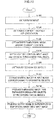
- FIG. 10 is a flowchart illustrating an example of a flow of image processing by the image processing device 100 according to the present embodiment.
- the input-image obtaining unit 110 obtains input images in which the view in the real world around a user is captured (step S102).
- the positioning unit 120 also determines the current location and orientation of the image processing device 100 (step S104).
- the matching unit 140 may retrieve a three-dimensional model corresponding to the current location, and obtain data on objects around the current location of the image processing device 100 from the corresponding three-dimensional model stored in the storage unit 130 (step S106).
- the matching unit 140 matches the feature points set in the input image with the feature points of the group of objects included in the obtained three-dimensional model (step S108).
- the emphasizing-process unit 180 distinguishes one or more designated objects designated by the object designating information (step S110).
- the emphasizing-process unit 180 extracts partial images of areas in the input image corresponding to the designated objects using the three-dimensional model (step S112).
- the emphasizing-process unit 180 generates the emphasized image that emphasizes the designated objects by processing and modifying the extracted partial images (step S114). Alternatively, a portion of the three-dimensional model may be modified to generate an emphasized image.
- the emphasizing-process unit 180 generates an output image by superimposing the generated emphasized image onto the input image (step S116). The output image generated in this manner is displayed on the screen of the display device 24 via the user-interface unit 170.
- an emphasized image that emphasized a designated object is generated and displayed by processing a partial image in an input image corresponding to the designated object in a three-dimensional model designated by the application function. Therefore, a designated object is emphatically displayed while natural appearance that appears in an input image from the viewpoint of the imager 22 mounted on the image processing device 100 that a user uses is kept. Accordingly, it can be easy for a user to find a designated object, such as a desired building or facility, in the real space.
- the use of a series of emphasized images that represent animation in which a designated object moves also allows a user to recognize the desired object very easily.
- the modification of a designated object in an output image also allows a user to understand additional information, such as a rank order, intuitively and easily.
- the method by which user's shaking the image processing device 100 triggers animation in which a designated object is shaken in an output image to be displayed also associates a motion of a user with an emphasized image, and the method can achieve an intuitive and easy-to-follow user interface that presents geographic information.
Landscapes
- Engineering & Computer Science (AREA)
- Physics & Mathematics (AREA)
- Theoretical Computer Science (AREA)
- General Physics & Mathematics (AREA)
- Mathematical Physics (AREA)
- Business, Economics & Management (AREA)
- Educational Administration (AREA)
- Educational Technology (AREA)
- Software Systems (AREA)
- Computer Graphics (AREA)
- Computer Hardware Design (AREA)
- General Engineering & Computer Science (AREA)
- Geometry (AREA)
- Architecture (AREA)
- Remote Sensing (AREA)
- Computer Vision & Pattern Recognition (AREA)
- Processing Or Creating Images (AREA)
- Navigation (AREA)
- User Interface Of Digital Computer (AREA)
- Apparatus For Radiation Diagnosis (AREA)
- Measuring And Recording Apparatus For Diagnosis (AREA)
Applications Claiming Priority (1)
| Application Number | Priority Date | Filing Date | Title |
|---|---|---|---|
| JP2010224347A JP5652097B2 (ja) | 2010-10-01 | 2010-10-01 | 画像処理装置、プログラム及び画像処理方法 |
Publications (2)
| Publication Number | Publication Date |
|---|---|
| EP2437237A2 true EP2437237A2 (de) | 2012-04-04 |
| EP2437237A3 EP2437237A3 (de) | 2015-05-27 |
Family
ID=44720661
Family Applications (1)
| Application Number | Title | Priority Date | Filing Date |
|---|---|---|---|
| EP11182368.8A Ceased EP2437237A3 (de) | 2010-10-01 | 2011-09-22 | Bildverarbeitungsvorrichtung, Bildverarbeitungsverfahren und computerlesbares Speichermedium |
Country Status (5)
| Country | Link |
|---|---|
| US (2) | US9536454B2 (de) |
| EP (1) | EP2437237A3 (de) |
| JP (1) | JP5652097B2 (de) |
| CN (2) | CN102542905B (de) |
| BR (1) | BRPI1106304A2 (de) |
Cited By (3)
| Publication number | Priority date | Publication date | Assignee | Title |
|---|---|---|---|---|
| WO2014072364A1 (en) * | 2012-11-12 | 2014-05-15 | Here Global B.V. | Method and apparatus for visually representing objects with a modified height |
| WO2014206726A1 (de) * | 2013-06-25 | 2014-12-31 | Robert Bosch Gmbh | Verfahren zum darstellen von objekten und navigationseinrichtung zum durchführen des verfahrens |
| CN106888316A (zh) * | 2016-12-31 | 2017-06-23 | 深圳天珑无线科技有限公司 | 单手查找电子地图的方法及其系统 |
Families Citing this family (15)
| Publication number | Priority date | Publication date | Assignee | Title |
|---|---|---|---|---|
| US9230223B2 (en) | 2011-12-05 | 2016-01-05 | Houzz, Inc. | Consistent presentation of content and passive relevance determination of content relationship in an on-line commerce system |
| US9069440B2 (en) * | 2012-06-05 | 2015-06-30 | Apple Inc. | Method, system and apparatus for providing a three-dimensional transition animation for a map view change |
| JP6064544B2 (ja) * | 2012-11-27 | 2017-01-25 | ソニー株式会社 | 画像処理装置、画像処理方法、プログラム及び端末装置 |
| JP6296056B2 (ja) | 2013-06-17 | 2018-03-20 | ソニー株式会社 | 画像処理装置、画像処理方法及びプログラム |
| DE102014110349A1 (de) * | 2013-08-09 | 2015-02-12 | Samsung Electronics Co., Ltd. | Hybride visuelle Kommunikation |
| JP6222440B2 (ja) * | 2013-10-07 | 2017-11-01 | コニカミノルタ株式会社 | Ar表示システム、およびar表示装置、情報処理装置、プログラム |
| JP2015104930A (ja) * | 2013-11-28 | 2015-06-08 | 株式会社デンソー | ヘッドアップディスプレイ装置 |
| CN105814611B (zh) * | 2013-12-17 | 2020-08-18 | 索尼公司 | 信息处理设备和方法以及非易失性计算机可读存储介质 |
| JP5762600B1 (ja) * | 2014-06-06 | 2015-08-12 | キヤノン株式会社 | 情報処理装置及び情報処理方法 |
| CN104484345A (zh) * | 2014-11-28 | 2015-04-01 | 广东工业大学 | 一种基于K-means聚类的水火弯板3D扫描模块的提取方法 |
| US10339390B2 (en) * | 2016-02-23 | 2019-07-02 | Semiconductor Components Industries, Llc | Methods and apparatus for an imaging system |
| WO2018139117A1 (ja) | 2017-01-27 | 2018-08-02 | ソニー株式会社 | 情報処理装置、情報処理方法およびそのプログラム |
| JP6976719B2 (ja) * | 2017-05-25 | 2021-12-08 | キヤノン株式会社 | 表示制御装置、表示制御方法及びプログラム |
| US10534962B2 (en) * | 2017-06-17 | 2020-01-14 | Matterport, Inc. | Automated classification based on photo-realistic image/model mappings |
| JP7746214B2 (ja) * | 2022-04-05 | 2025-09-30 | Kddi株式会社 | マッチング装置、方法及びプログラム |
Citations (1)
| Publication number | Priority date | Publication date | Assignee | Title |
|---|---|---|---|---|
| JP2005227590A (ja) | 2004-02-13 | 2005-08-25 | Nec Toshiba Space Systems Ltd | 位置情報提供方法および地図案内装置 |
Family Cites Families (87)
| Publication number | Priority date | Publication date | Assignee | Title |
|---|---|---|---|---|
| US5262856A (en) * | 1992-06-04 | 1993-11-16 | Massachusetts Institute Of Technology | Video image compositing techniques |
| JPH06231275A (ja) * | 1993-01-29 | 1994-08-19 | Hitachi Ltd | 画像シミュレーション方法 |
| US5467441A (en) * | 1993-07-21 | 1995-11-14 | Xerox Corporation | Method for operating on objects in a first image using an object-based model data structure to produce a second contextual image having added, replaced or deleted objects |
| JP3333319B2 (ja) * | 1994-06-03 | 2002-10-15 | 三菱電機株式会社 | 2次元3次元統合型cadシステム |
| EP0972285A4 (de) * | 1995-10-08 | 2002-04-03 | Face Imaging Ltd | Verfahren zum automatischen computerunterstützten audiovisuellen kopieren von filmen |
| US6512857B1 (en) * | 1997-05-09 | 2003-01-28 | Sarnoff Corporation | Method and apparatus for performing geo-spatial registration |
| US6229546B1 (en) * | 1997-09-09 | 2001-05-08 | Geosoftware, Inc. | Rapid terrain model generation with 3-D object features and user customization interface |
| JP4025442B2 (ja) * | 1998-12-01 | 2007-12-19 | 富士通株式会社 | 三次元モデル変換装置及び方法 |
| US6879946B2 (en) * | 1999-11-30 | 2005-04-12 | Pattern Discovery Software Systems Ltd. | Intelligent modeling, transformation and manipulation system |
| JP4208113B2 (ja) * | 2000-04-19 | 2009-01-14 | 富士フイルム株式会社 | アルバム作成方法および装置並びに記録媒体 |
| US7193633B1 (en) * | 2000-04-27 | 2007-03-20 | Adobe Systems Incorporated | Method and apparatus for image assisted modeling of three-dimensional scenes |
| JP2002083285A (ja) * | 2000-07-07 | 2002-03-22 | Matsushita Electric Ind Co Ltd | 画像合成装置および画像合成方法 |
| FR2814570B1 (fr) * | 2000-09-27 | 2003-11-21 | Cyber Act | Procede interactif de communication d'informations a des utilisateurs d'un reseau de communication informatique, notamment de type internet |
| KR100875743B1 (ko) * | 2001-01-16 | 2008-12-26 | 엔엑스피 비 브이 | 모션 보상된 보간에서 헤일로 효과를 감소시키는 방법 |
| US6650326B1 (en) * | 2001-01-22 | 2003-11-18 | Navigation Technologies Corp. | Method of handling context during scaling with a map display |
| US6980697B1 (en) * | 2001-02-01 | 2005-12-27 | At&T Corp. | Digitally-generated lighting for video conferencing applications |
| ITMI20010538A1 (it) * | 2001-03-14 | 2002-09-14 | Phoenix Tools S R L | Sistema per la creazione la visualizzazione e la gestione di oggetti tridimensionali su pagine web e metodo relativo |
| GB0114157D0 (en) * | 2001-06-11 | 2001-08-01 | Canon Kk | 3D Computer modelling apparatus |
| US7019748B2 (en) * | 2001-08-15 | 2006-03-28 | Mitsubishi Electric Research Laboratories, Inc. | Simulating motion of static objects in scenes |
| JP2003053027A (ja) * | 2001-08-21 | 2003-02-25 | Shinsedai Kk | 音楽演奏ゲーム装置 |
| US7046840B2 (en) * | 2001-11-09 | 2006-05-16 | Arcsoft, Inc. | 3-D reconstruction engine |
| US20030108329A1 (en) * | 2001-12-12 | 2003-06-12 | Meric Adriansen | Advertising method and system |
| KR100439756B1 (ko) * | 2002-01-09 | 2004-07-12 | 주식회사 인피니트테크놀로지 | 3차원 가상내시경 화면 표시장치 및 그 방법 |
| JP2003216977A (ja) * | 2002-01-17 | 2003-07-31 | Sony Corp | 情報提供装置及び情報提供方法、記憶媒体、並びにコンピュータ・プログラム |
| JP2003317116A (ja) * | 2002-04-25 | 2003-11-07 | Sony Corp | 3次元仮想空間における情報提示装置及び情報提示方法、並びにコンピュータ・プログラム |
| JP3944019B2 (ja) * | 2002-07-31 | 2007-07-11 | キヤノン株式会社 | 情報処理装置および方法 |
| JP2004094773A (ja) * | 2002-09-03 | 2004-03-25 | Nec Corp | 頭部装着物画像合成方法、化粧画像合成方法、頭部装着物画像合成装置、化粧画像合成装置及びプログラム |
| JP3748545B2 (ja) * | 2002-09-19 | 2006-02-22 | 株式会社ナムコ | プログラム、情報記憶媒体及び画像生成装置 |
| JP2004271901A (ja) * | 2003-03-07 | 2004-09-30 | Matsushita Electric Ind Co Ltd | 地図表示装置 |
| JP4085918B2 (ja) * | 2003-07-18 | 2008-05-14 | ソニー株式会社 | 3次元モデル処理装置、および3次元モデル処理方法、並びにコンピュータ・プログラム |
| SE0401582L (sv) * | 2004-06-18 | 2005-05-10 | Totalfoersvarets Forskningsins | Interaktivt förfarande för att presentera information i en bild |
| US20060044307A1 (en) * | 2004-08-24 | 2006-03-02 | Kyuman Song | System and method for visually representing project metrics on 3-dimensional building models |
| US7929800B2 (en) * | 2007-02-06 | 2011-04-19 | Meadow William D | Methods and apparatus for generating a continuum of image data |
| JP4606898B2 (ja) * | 2005-02-15 | 2011-01-05 | 三菱電機株式会社 | 情報生成装置及び検索装置 |
| WO2006093250A1 (ja) * | 2005-03-04 | 2006-09-08 | National University Corporation NARA Institute of Science and Technology | 動き計測装置、動き計測システム、車載機器、動き計測方法、動き計測プログラム、およびコンピュータ読み取り可能な記録媒体 |
| US20060223635A1 (en) * | 2005-04-04 | 2006-10-05 | Outland Research | method and apparatus for an on-screen/off-screen first person gaming experience |
| US8226011B2 (en) * | 2005-04-06 | 2012-07-24 | Eidgenoessische Technische Hochshcule Zuerich | Method of executing an application in a mobile device |
| US8040361B2 (en) * | 2005-04-11 | 2011-10-18 | Systems Technology, Inc. | Systems and methods for combining virtual and real-time physical environments |
| JP2006338092A (ja) * | 2005-05-31 | 2006-12-14 | Nec Corp | パタン照合方法、パタン照合システム及びパタン照合プログラム |
| US7728869B2 (en) * | 2005-06-14 | 2010-06-01 | Lg Electronics Inc. | Matching camera-photographed image with map data in portable terminal and travel route guidance method |
| US7840032B2 (en) * | 2005-10-04 | 2010-11-23 | Microsoft Corporation | Street-side maps and paths |
| JP4246195B2 (ja) * | 2005-11-01 | 2009-04-02 | パナソニック株式会社 | カーナビゲーションシステム |
| US8094928B2 (en) * | 2005-11-14 | 2012-01-10 | Microsoft Corporation | Stereo video for gaming |
| JP4777786B2 (ja) * | 2006-02-01 | 2011-09-21 | クラリオン株式会社 | 車載地図表示装置 |
| US8009910B2 (en) * | 2006-05-05 | 2011-08-30 | Valtion Teknillinen Tutkimuskeskus | Method, a system, a computer program product and a user interface for segmenting image sets |
| EP1862969A1 (de) * | 2006-06-02 | 2007-12-05 | Eidgenössische Technische Hochschule Zürich | Verfahren und System zur Generierung einer Darstellung einer dynamisch wechselnden 3D-Szene |
| US20070291034A1 (en) * | 2006-06-20 | 2007-12-20 | Dones Nelson C | System for presenting a navigable virtual subway system, and method for operating and using the same |
| JP4926817B2 (ja) * | 2006-08-11 | 2012-05-09 | キヤノン株式会社 | 指標配置情報計測装置および方法 |
| US8073213B2 (en) * | 2006-10-30 | 2011-12-06 | General Electric Company | Method for generating a registered image relative to a cardiac cycle and a respiratory cycle of a person |
| JP5177615B2 (ja) * | 2006-12-01 | 2013-04-03 | 任天堂株式会社 | ゲームプログラム、ゲーム装置、ゲームシステム、およびゲーム処理方法 |
| US7750825B2 (en) * | 2007-03-09 | 2010-07-06 | Adobe Systems Incorporated | System and method for navigation of display data |
| US7941429B2 (en) * | 2007-07-10 | 2011-05-10 | Yahoo! Inc. | Interface for visually searching and navigating objects |
| US8089522B2 (en) * | 2007-09-07 | 2012-01-03 | Regents Of The University Of Minnesota | Spatial-temporal multi-resolution image sensor with adaptive frame rates for tracking movement in a region of interest |
| JP5053776B2 (ja) * | 2007-09-14 | 2012-10-17 | 株式会社デンソー | 車両用視界支援システム、車載装置、及び、情報配信装置 |
| DE102007048320A1 (de) * | 2007-10-09 | 2008-05-15 | Daimler Ag | Verfahren zur Anpassung eines Objektmodells an eine dreidimensionale Punktwolke |
| US20140300610A1 (en) * | 2007-11-16 | 2014-10-09 | Adobe Systems Incorporated | System and method for using time re-mapping for computer-generated animation |
| US8134558B1 (en) * | 2007-12-06 | 2012-03-13 | Adobe Systems Incorporated | Systems and methods for editing of a computer-generated animation across a plurality of keyframe pairs |
| US20090213270A1 (en) * | 2008-02-22 | 2009-08-27 | Ryan Ismert | Video indexing and fingerprinting for video enhancement |
| US8743125B2 (en) * | 2008-03-11 | 2014-06-03 | Sony Computer Entertainment Inc. | Method and apparatus for providing natural facial animation |
| US8737721B2 (en) * | 2008-05-07 | 2014-05-27 | Microsoft Corporation | Procedural authoring |
| US8391642B1 (en) * | 2008-05-12 | 2013-03-05 | Hewlett-Packard Development Company, L.P. | Method and system for creating a custom image |
| AU2008359900A1 (en) * | 2008-07-31 | 2010-02-04 | Tele Atlas B.V. | Method of displaying navigation data in 3D |
| AT10520U3 (de) * | 2008-09-05 | 2013-10-15 | Knapp Systemintegration Gmbh | Vorrichtung und verfahren zur visuellen unterstützung von kommissioniervorgängen |
| AU2008362229A1 (en) * | 2008-09-25 | 2010-04-01 | Tele Atlas B.V. | Method of and arrangement for blurring an image |
| TW201016016A (en) * | 2008-10-07 | 2010-04-16 | Euclid Discoveries Llc | Feature-based video compression |
| JP2010118019A (ja) * | 2008-11-14 | 2010-05-27 | Sharp Corp | 端末装置、配信装置、端末装置の制御方法、配信装置の制御方法、制御プログラムおよび記録媒体 |
| CN101750072A (zh) * | 2008-12-08 | 2010-06-23 | 北京龙图通信息技术有限公司 | 三维动画视频导航方法及系统 |
| US9098926B2 (en) * | 2009-02-06 | 2015-08-04 | The Hong Kong University Of Science And Technology | Generating three-dimensional façade models from images |
| US8111300B2 (en) * | 2009-04-22 | 2012-02-07 | Qualcomm Incorporated | System and method to selectively combine video frame image data |
| KR101671900B1 (ko) * | 2009-05-08 | 2016-11-03 | 삼성전자주식회사 | 가상 세계에서의 객체를 제어하는 시스템, 방법 및 기록 매체 |
| JP5290864B2 (ja) * | 2009-05-18 | 2013-09-18 | キヤノン株式会社 | 位置姿勢推定装置及び方法 |
| US8542252B2 (en) * | 2009-05-29 | 2013-09-24 | Microsoft Corporation | Target digitization, extraction, and tracking |
| US8698841B2 (en) * | 2009-07-10 | 2014-04-15 | Georeplica, Inc. | System, method and process of identifying and advertising organizations or other entities by overlaying image files on cartographic mapping applications |
| US8718338B2 (en) * | 2009-07-23 | 2014-05-06 | General Electric Company | System and method to compensate for respiratory motion in acquired radiography images |
| CN101640724A (zh) * | 2009-08-21 | 2010-02-03 | 北京协进科技发展有限公司 | 一种控制手机地图的方法及手机 |
| KR100982768B1 (ko) * | 2009-09-21 | 2010-09-20 | (주)올라웍스 | 단말기의 각도에 따라 서로 다른 영상 정보를 제공하기 위한 방법, 단말기 및 컴퓨터 판독 가능한 기록 매체 |
| JP5340895B2 (ja) * | 2009-11-24 | 2013-11-13 | 株式会社ソニー・コンピュータエンタテインメント | 画像データ作成支援装置および画像データ作成支援方法 |
| US8566020B2 (en) * | 2009-12-01 | 2013-10-22 | Nokia Corporation | Method and apparatus for transforming three-dimensional map objects to present navigation information |
| US8907947B2 (en) * | 2009-12-14 | 2014-12-09 | Dassault Systèmes | Method and system for navigating in a product structure of a product |
| CN102713664B (zh) * | 2010-01-12 | 2016-03-16 | 诺基亚技术有限公司 | 协作式位置/方位估计 |
| US20110227919A1 (en) * | 2010-03-17 | 2011-09-22 | International Business Machines Corporation | Managing object attributes in a virtual world environment |
| WO2012071445A2 (en) * | 2010-11-24 | 2012-05-31 | Google Inc. | Guided navigation through geo-located panoramas |
| US8749573B2 (en) * | 2011-05-26 | 2014-06-10 | Nokia Corporation | Method and apparatus for providing input through an apparatus configured to provide for display of an image |
| US10019962B2 (en) * | 2011-08-17 | 2018-07-10 | Microsoft Technology Licensing, Llc | Context adaptive user interface for augmented reality display |
| US9081177B2 (en) * | 2011-10-07 | 2015-07-14 | Google Inc. | Wearable computer with nearby object response |
| KR101923929B1 (ko) * | 2012-06-06 | 2018-11-30 | 삼성전자주식회사 | 증강 현실 서비스를 제공하는 이동통신 단말기 및 증강 현실 서비스에 대한 화면으로의 화면 전환 방법 |
| US8811764B1 (en) * | 2012-10-25 | 2014-08-19 | Google Inc. | System and method for scene dependent multi-band blending |
-
2010
- 2010-10-01 JP JP2010224347A patent/JP5652097B2/ja not_active Expired - Fee Related
-
2011
- 2011-09-22 EP EP11182368.8A patent/EP2437237A3/de not_active Ceased
- 2011-09-23 BR BRPI1106304-1A patent/BRPI1106304A2/pt not_active IP Right Cessation
- 2011-09-23 CN CN201110291622.0A patent/CN102542905B/zh not_active Expired - Fee Related
- 2011-09-23 CN CN2011203658217U patent/CN202502670U/zh not_active Expired - Fee Related
- 2011-09-27 US US13/246,159 patent/US9536454B2/en not_active Expired - Fee Related
-
2016
- 2016-11-22 US US15/358,480 patent/US10636326B2/en not_active Expired - Fee Related
Patent Citations (1)
| Publication number | Priority date | Publication date | Assignee | Title |
|---|---|---|---|---|
| JP2005227590A (ja) | 2004-02-13 | 2005-08-25 | Nec Toshiba Space Systems Ltd | 位置情報提供方法および地図案内装置 |
Cited By (4)
| Publication number | Priority date | Publication date | Assignee | Title |
|---|---|---|---|---|
| WO2014072364A1 (en) * | 2012-11-12 | 2014-05-15 | Here Global B.V. | Method and apparatus for visually representing objects with a modified height |
| US9412150B2 (en) | 2012-11-12 | 2016-08-09 | Here Global B.V. | Method and apparatus for visually representing objects with a modified height |
| WO2014206726A1 (de) * | 2013-06-25 | 2014-12-31 | Robert Bosch Gmbh | Verfahren zum darstellen von objekten und navigationseinrichtung zum durchführen des verfahrens |
| CN106888316A (zh) * | 2016-12-31 | 2017-06-23 | 深圳天珑无线科技有限公司 | 单手查找电子地图的方法及其系统 |
Also Published As
| Publication number | Publication date |
|---|---|
| BRPI1106304A2 (pt) | 2013-02-19 |
| US10636326B2 (en) | 2020-04-28 |
| US20170076638A1 (en) | 2017-03-16 |
| CN102542905B (zh) | 2016-01-13 |
| EP2437237A3 (de) | 2015-05-27 |
| JP2012079129A (ja) | 2012-04-19 |
| US9536454B2 (en) | 2017-01-03 |
| JP5652097B2 (ja) | 2015-01-14 |
| CN202502670U (zh) | 2012-10-24 |
| US20120082341A1 (en) | 2012-04-05 |
| CN102542905A (zh) | 2012-07-04 |
Similar Documents
| Publication | Publication Date | Title |
|---|---|---|
| US10636326B2 (en) | Image processing apparatus, image processing method, and computer-readable storage medium for displaying three-dimensional virtual objects to modify display shapes of objects of interest in the real world | |
| US10580162B2 (en) | Method for determining the pose of a camera and for recognizing an object of a real environment | |
| EP3712810B1 (de) | Vorrichtung, informationsverarbeitungsvorrichtung und verfahren | |
| CN105046752B (zh) | 用于在真实环境的视图中描绘虚拟信息的方法 | |
| US10025985B2 (en) | Information processing apparatus, information processing method, and non-transitory computer-readable storage medium storing program | |
| CN104748738B (zh) | 室内定位导航方法和系统 | |
| EP2791908B1 (de) | Personalisierung von erweiterter realität | |
| EP3044726B1 (de) | Landmarkenidentifizierung aus einer aus geografischen bilddaten erzeugten punktwolke | |
| US9767610B2 (en) | Image processing device, image processing method, and terminal device for distorting an acquired image | |
| CN111638796A (zh) | 虚拟对象的展示方法、装置、计算机设备及存储介质 | |
| JP2010118019A (ja) | 端末装置、配信装置、端末装置の制御方法、配信装置の制御方法、制御プログラムおよび記録媒体 | |
| KR20150075532A (ko) | 증강 현실 제공 장치 및 방법 | |
| KR20120027346A (ko) | 방향 기반의 검색 시스템 및 방법 | |
| US12033351B2 (en) | Use of image sensors to query real world for geo-reference information | |
| JP5981371B2 (ja) | 姿勢によって拡張現実感の表示を制御する情報端末、システム、プログラム及び方法 | |
| KR101568741B1 (ko) | 모바일 증강현실 기반의 정보 제공 시스템 | |
| WO2013134108A1 (en) | Non-photorealistic rendering of geographic features in a map | |
| JP5951465B2 (ja) | 道路情報に基づいて見通しエリアを決定するプログラム、情報端末、サーバ及び方法 | |
| JP5971387B2 (ja) | 端末装置、物体識別方法、及び情報処理装置 | |
| JP6172353B2 (ja) | 端末装置、物体識別方法、情報処理装置、及びプログラム |
Legal Events
| Date | Code | Title | Description |
|---|---|---|---|
| PUAI | Public reference made under article 153(3) epc to a published international application that has entered the european phase |
Free format text: ORIGINAL CODE: 0009012 |
|
| 17P | Request for examination filed |
Effective date: 20111007 |
|
| AK | Designated contracting states |
Kind code of ref document: A2 Designated state(s): AL AT BE BG CH CY CZ DE DK EE ES FI FR GB GR HR HU IE IS IT LI LT LU LV MC MK MT NL NO PL PT RO RS SE SI SK SM TR |
|
| AX | Request for extension of the european patent |
Extension state: BA ME |
|
| PUAL | Search report despatched |
Free format text: ORIGINAL CODE: 0009013 |
|
| AK | Designated contracting states |
Kind code of ref document: A3 Designated state(s): AL AT BE BG CH CY CZ DE DK EE ES FI FR GB GR HR HU IE IS IT LI LT LU LV MC MK MT NL NO PL PT RO RS SE SI SK SM TR |
|
| AX | Request for extension of the european patent |
Extension state: BA ME |
|
| RIC1 | Information provided on ipc code assigned before grant |
Ipc: G09B 29/10 20060101ALI20150420BHEP Ipc: G09B 29/12 20060101AFI20150420BHEP |
|
| 17Q | First examination report despatched |
Effective date: 20170210 |
|
| 18R | Application refused |
Effective date: 20180113 |