EP2244099A1 - In satellitennavigation/koppelnavigation integrierte positionierungsvorrichtung - Google Patents
In satellitennavigation/koppelnavigation integrierte positionierungsvorrichtung Download PDFInfo
- Publication number
- EP2244099A1 EP2244099A1 EP09710624A EP09710624A EP2244099A1 EP 2244099 A1 EP2244099 A1 EP 2244099A1 EP 09710624 A EP09710624 A EP 09710624A EP 09710624 A EP09710624 A EP 09710624A EP 2244099 A1 EP2244099 A1 EP 2244099A1
- Authority
- EP
- European Patent Office
- Prior art keywords
- positioning calculation
- calculation module
- module
- navigation
- velocity
- Prior art date
- Legal status (The legal status is an assumption and is not a legal conclusion. Google has not performed a legal analysis and makes no representation as to the accuracy of the status listed.)
- Granted
Links
Images


Classifications
-
- G—PHYSICS
- G01—MEASURING; TESTING
- G01C—MEASURING DISTANCES, LEVELS OR BEARINGS; SURVEYING; NAVIGATION; GYROSCOPIC INSTRUMENTS; PHOTOGRAMMETRY OR VIDEOGRAMMETRY
- G01C23/00—Combined instruments indicating more than one navigational value, e.g. for aircraft; Combined measuring devices for measuring two or more variables of movement, e.g. distance, speed or acceleration
-
- G—PHYSICS
- G01—MEASURING; TESTING
- G01C—MEASURING DISTANCES, LEVELS OR BEARINGS; SURVEYING; NAVIGATION; GYROSCOPIC INSTRUMENTS; PHOTOGRAMMETRY OR VIDEOGRAMMETRY
- G01C21/00—Navigation; Navigational instruments not provided for in groups G01C1/00 - G01C19/00
- G01C21/10—Navigation; Navigational instruments not provided for in groups G01C1/00 - G01C19/00 by using measurements of speed or acceleration
- G01C21/12—Navigation; Navigational instruments not provided for in groups G01C1/00 - G01C19/00 by using measurements of speed or acceleration executed aboard the object being navigated; Dead reckoning
- G01C21/16—Navigation; Navigational instruments not provided for in groups G01C1/00 - G01C19/00 by using measurements of speed or acceleration executed aboard the object being navigated; Dead reckoning by integrating acceleration or speed, i.e. inertial navigation
- G01C21/165—Navigation; Navigational instruments not provided for in groups G01C1/00 - G01C19/00 by using measurements of speed or acceleration executed aboard the object being navigated; Dead reckoning by integrating acceleration or speed, i.e. inertial navigation combined with non-inertial navigation instruments
-
- G—PHYSICS
- G01—MEASURING; TESTING
- G01S—RADIO DIRECTION-FINDING; RADIO NAVIGATION; DETERMINING DISTANCE OR VELOCITY BY USE OF RADIO WAVES; LOCATING OR PRESENCE-DETECTING BY USE OF THE REFLECTION OR RERADIATION OF RADIO WAVES; ANALOGOUS ARRANGEMENTS USING OTHER WAVES
- G01S19/00—Satellite radio beacon positioning systems; Determining position, velocity or attitude using signals transmitted by such systems
- G01S19/01—Satellite radio beacon positioning systems transmitting time-stamped messages, e.g. GPS [Global Positioning System], GLONASS [Global Orbiting Navigation Satellite System] or GALILEO
- G01S19/13—Receivers
- G01S19/23—Testing, monitoring, correcting or calibrating of receiver elements
-
- G—PHYSICS
- G01—MEASURING; TESTING
- G01S—RADIO DIRECTION-FINDING; RADIO NAVIGATION; DETERMINING DISTANCE OR VELOCITY BY USE OF RADIO WAVES; LOCATING OR PRESENCE-DETECTING BY USE OF THE REFLECTION OR RERADIATION OF RADIO WAVES; ANALOGOUS ARRANGEMENTS USING OTHER WAVES
- G01S19/00—Satellite radio beacon positioning systems; Determining position, velocity or attitude using signals transmitted by such systems
- G01S19/38—Determining a navigation solution using signals transmitted by a satellite radio beacon positioning system
- G01S19/39—Determining a navigation solution using signals transmitted by a satellite radio beacon positioning system the satellite radio beacon positioning system transmitting time-stamped messages, e.g. GPS [Global Positioning System], GLONASS [Global Orbiting Navigation Satellite System] or GALILEO
- G01S19/42—Determining position
- G01S19/48—Determining position by combining or switching between position solutions derived from the satellite radio beacon positioning system and position solutions derived from a further system
- G01S19/49—Determining position by combining or switching between position solutions derived from the satellite radio beacon positioning system and position solutions derived from a further system whereby the further system is an inertial position system, e.g. loosely-coupled
-
- G—PHYSICS
- G01—MEASURING; TESTING
- G01S—RADIO DIRECTION-FINDING; RADIO NAVIGATION; DETERMINING DISTANCE OR VELOCITY BY USE OF RADIO WAVES; LOCATING OR PRESENCE-DETECTING BY USE OF THE REFLECTION OR RERADIATION OF RADIO WAVES; ANALOGOUS ARRANGEMENTS USING OTHER WAVES
- G01S19/00—Satellite radio beacon positioning systems; Determining position, velocity or attitude using signals transmitted by such systems
- G01S19/38—Determining a navigation solution using signals transmitted by a satellite radio beacon positioning system
- G01S19/39—Determining a navigation solution using signals transmitted by a satellite radio beacon positioning system the satellite radio beacon positioning system transmitting time-stamped messages, e.g. GPS [Global Positioning System], GLONASS [Global Orbiting Navigation Satellite System] or GALILEO
- G01S19/42—Determining position
- G01S19/45—Determining position by combining measurements of signals from the satellite radio beacon positioning system with a supplementary measurement
- G01S19/47—Determining position by combining measurements of signals from the satellite radio beacon positioning system with a supplementary measurement the supplementary measurement being an inertial measurement, e.g. tightly coupled inertial
Definitions
- the present invention relates to a satellite navigation/dead-reckoning navigation integrated positioning device that integrates an observation obtained by receiving a positioning signal from a navigation satellite and an observation obtained from a dead-reckoning navigation device to perform positioning.
- GPS/DR integrated positioning device in which an observation (hereinafter, referred to as “GPS observation”) obtained from a GPS positioning system, for example, as a non-autonomous system, and an observation (hereinafter, referred to as "DR observation”) obtained from a dead-reckoning navigation system (DR: dead-reckoning navigation system), as an autonomous system, are integrated (for example, see Patent Documents 1 and 2).
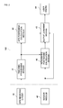
- FIG. 1 is a block diagram of a typical example of the aforementioned integration type.
- Fig. 1(A) shows a loosely-coupled approach
- Fig. 1(B) shows a tightly-coupled approach and a deeply-coupled approach
- a tracking processing module 11 tracks a phase of a GPS positioning signal of a baseband obtained by receiving a signal from a GPS satellite, and finds a position, a velocity, and the like of each satellite.
- a GPS positioning calculation module 12 finds a position and a velocity at a receiving point based on a pseudo range (PR), a Doppler frequency observation and the position and velocity of each satellite found by the tracking processing module 11.
- a DR positioning calculation module 13 finds the position and velocity based on external support data of an inertial sensor and the like.
- PR pseudo range
- an integrated positioning calculation module 14 integrates the GPS observation, such as the position and velocity obtained by the GPS positioning calculation module 12 and the DR observation, such as the position and velocity obtained by the DR positioning calculation module 13 to provide the position and velocity of higher quality to a user.
- a tracking processing module 21 tracks a phase of a GPS positioning signal of a baseband obtained by receiving a signal from a GPS satellite, and finds a position, a velocity, and the like of each satellite.
- an integrated positioning calculation module 22 integrates a pseudo range and a Doppler frequency obtained by the tracking processing module 21 as the GPS observation and an external support data of the inertial sensor and the like as the DR observation in one integrated positioning calculation module 22 to provide the position and velocity of higher quality to a user.
- the integrated positioning calculation module 22 uses a baseband complex signal (I, Q) obtained by the tracking processing module 21 as the GPS observation and an external support data of the inertial sensor as the DR observation to perform an integrated positioning calculation.
- I, Q baseband complex signal
- the GPS positioning calculation module 12 and the integrated positioning calculation module 14 of the loosely-coupled approach and the integrated positioning calculation module 22 of the tightly/deeply-coupled approach are also referred to as a "navigation filter" in which usually the position and position error, the velocity and velocity error, inertial sensor error and the like are estimated by a Kalman filter, and the estimated respective errors are negatively fed back as a correction amount to a certain portion to be corrected.
- Patent Documents 1 and 2 being used is a device which integrates the external support data of a low-price inertial sensor (such as a gyroscope and an acceleration sensor), map data and the like, and the GPS observation using the loosely-coupled approach or the tightly-coupled approach.
- a low-price inertial sensor such as a gyroscope and an acceleration sensor
- the data of the position, velocity, and the like at the receiving point found by the GPS positioning calculation module and the position and velocity found by the DR positioning calculation module are integrated.
- the GPS data cannot be utilized for calculation of the DR positioning.
- a general method for the GPS positioning needs at least four satellites to find four variables of a three-dimensional position (X, Y, Z) and a time.
- the GPS data cannot be utilized for the DR calculation.
- the biggest drawback of the loosely-coupled approach is the error of the position and velocity obtained from the GPS positioning calculation module 12 being colored noise, which does not meet a white noise error condition as an indispensable requirement of a Kalman filter in the integrated positioning calculation module 22.
- the pseudo range and Doppler frequency as the GPS observation, and the DR observation are integrated in one integrated positioning calculation module; therefore, detailed knowledge about the GPS is required to design the Kalman filter. Furthermore, compared with the loosely-coupled approach, the integrated positioning calculation module has a very complex design.
- navigation data when an abnormality occurs in an output from the inertial sensor, for example, the position, velocity, attitude or the like (hereinafter, referred to as navigation data) cannot be provided to the user.
- a positioning result fed back to the tracking processing module of the GPS positioning signal is affected by an input value (such as map-match data) from the sensor module and the user. For this reason, for example, if the abnormal sensor data is input, the GPS satellite cannot be tracked to make it impossible to detect the abnormality of the sensor using the GPS positioning results.
- an object of the invention is to provide a satellite navigation/dead-reckoning navigation integrated positioning device which can be constituted by low cost, and in which accuracy of the navigation data including the position and velocity is improved.
- the satellite navigation/dead-reckoning navigation integrated positioning device of the invention is constituted as below in order to solve the problems.
- a satellite navigation/dead-reckoning navigation integrated positioning device is configured to include:
- the position and velocity of the moving body can be found based on the pseudo range and Doppler frequency information already observed. Further, if the external support data becomes abnormal and thus the integrated positioning calculation is impossible, a calculation result by the satellite navigation positioning calculation module can be provided to an user.
- the external support data may include, for example, data by an inertial sensor, and the abnormality determination module may compare the result of the positioning calculation by the satellite navigation positioning calculation module with the data by the inertial sensor to determine the abnormality of the inertial sensor.
- the abnormality of the inertial sensor can be detected; therefore, positioning accuracy can be prevented from lowering due to the use of the inertial sensor in an abnormality state.
- the external support data may include, for example, map data input information
- the abnormality determination module may compare the result of the positioning calculation by the satellite navigation positioning calculation module with the map data to determine the abnormality of the map data input information.
- the abnormality of the map data input information can be detected; therefore, positioning accuracy can be prevented from lowering due to the use of the abnormal map data.
- the abnormality determination module may compare the result found by the satellite navigation positioning calculation module with the result found by the integrated positioning calculation module to determine the abnormality of the result of the calculation of the integrated positioning calculation module.
- the abnormality of the external support data used for the integrated positioning calculation or the abnormality of the integrated positioning calculation module can be detected; therefore, the abnormal navigation data can be prevented from being provided to the user.
- a module may be provided to output the calculation results by the satellite navigation positioning calculation module to the user if the abnormality determination module determines an abnormality. The user may be informed of the abnormality state along with the calculation result.
- the calculation result of the satellite navigation positioning calculation module can be obtained. Additionally, if the abnormality state is output to the user, the user can grasp the abnormality state.
- the integrated positioning calculation module when, for example, resuming the positioning calculation from a state where the integrated positioning calculation module is stopped due to the abnormality of the external support data, may resume the integrated positioning calculation using the position and the velocity found by the satellite navigation positioning calculation module as initial values.
- the integrated positioning calculation module may execute the positioning calculation based on the pseudo range and the Doppler frequency information by a single difference between satellites found by the tracking processing module.
- the integrated positioning calculation module does not need to estimate a clock error of a receiver and changes thereof by the Kalman filter. Therefore, not only a computational load of the Kalman filter in the integrated positioning calculation module can be reduced, but also the clock error and a model of the changes thereof do not need to be considered.
- the position and velocity of the moving body can be obtained based on the pseudo range and Doppler frequency information already observed. Further, in a case where the external support data becomes abnormal and thus the integrated positioning calculation is impossible, the calculation result by the satellite navigation positioning calculation module can be provided to the user.
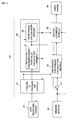
- Fig. 2 is a block diagram showing a configuration of a satellite navigation/dead-reckoning navigation integrated positioning device according to a first embodiment.
- a GPS receiving circuit 30 converts a positioning signal from a satellite received by a GPS antenna into an intermediate frequency and A/D-converts it to output a so-called baseband GPS positioning signal.
- a sensor module 40 is an external device, which includes at least an acceleration sensor, an angular velocity sensor, and a gyroscope inertial sensor, for obtaining orientation information and outputs external support data.
- map position input information maps-match data
- error input information of the map position maps-match data error
- a tracking processing module 31 performs, based on the above GPS positioning signal, acquisition processing and tracking processing thereof and demodulation processing of a navigation message including ephemeris data (satellite orbit information), and gives a pseudo-range observation and a Doppler frequency observation to a GPS positioning calculation module 32 and an integrated positioning calculation module 42.
- the GPS positioning calculation module 32 calculates the navigation data such as a position, a velocity by a usual method based on the pseudo-range observation, the Doppler frequency observation, the ephemeris data and the like.
- the integrated positioning calculation module 42 estimates the position, position error, velocity, velocity error, error of the external support data of the inertial sensor or the like using a known Kalman filter. Then, the integrated positioning calculation module 42 gives the navigation data such as the position, velocity and the like to an output judgment module 43. Moreover, the estimated error of the external support data is fed back to a predetermined processing module as a correction amount.
- the navigation data of the GPS positioning calculation module 32 is calculated independent of the integrated positioning calculation module 42. With this configuration, even if an abnormality caused due to the external support data occurs in the navigation data of the integrated positioning calculation module 42, the navigation data of the GPS positioning calculation module 32 is not affected by the abnormality of the external support data, and the navigation data of the GPS positioning calculation module 32 can be used to determine an abnormality of the navigation data of the integrated positioning calculation module 42. That is, in the output judgment module 43, all or any piece of the navigation data calculated by the GPS positioning calculation module 32 can be used as a comparative criterion to determine reliability of the output of the integrated positioning calculation module 42 output to a hardware/software 44 of the user.
- GPS positioning calculation module 32 and the integrated positioning calculation module 42 are provided, along with the pseudo range and Doppler frequency, with the ephemeris data, which has no direct relation therewith in the first embodiment, thus is omitted in the figure.
- Fig. 3 is a flowchart showing a procedure of abnormality determination of the integrated positioning calculation module executed by the output judgment module 43.
- the output judgment module 43 compares the output of the GPS positioning calculation module 32 and the output of the integrated positioning calculation module 42 (S11). In an example shown in Fig. 3 , the reliability of the output data of the integrated positioning calculation module 42 is determined by the AND condition of the position determination, velocity determination and attitude determination of the navigation data (S12, S 13, S14).
- the navigation data found by the GPS positioning calculation module 32 is switched to be output to the hardware/software 44 of the user (S12 ⁇ S16).
- the navigation data found by the GPS positioning calculation module 32 is switched to be output to the hardware/software 44 of the user (S13 ⁇ S16).
- the navigation data found by the GPS positioning calculation module 32 is switched to be output to the hardware/software 44 of the user (S14 ⁇ S16).
- the attitude of the moving body is an orientation which the moving body is directed, and is found, for example, from a position vector at a certain time in a case of being found based on the position information, and is found using a ratio with respect to a horizontal velocity component in a case of being found based on the velocity information.
- the navigation data found by the integrated positioning calculation module 42 is output to the hardware/software 44 of the user.
- the processing of the integrated positioning calculation module is resumed using the position and velocity found by the GPS positioning calculation module 32 as initial values or the velocity thereof as an initial value.
- the reliability of the output data of the integrated positioning calculation module 42 may be determined by a combination of the OR condition of the position determination, velocity determination and attitude determination of the navigation data, or by the AND or OR condition of any two of them and the AND or OR condition of the rest. For example, determination may be performed by a condition of (position AND velocity) OR attitude, or a condition of (position OR velocity) AND attitude.
- Fig. 4 is a flowchart showing a procedure of abnormality determination of the external support data executed by the output judgment module 43.
- the output judgment module 43 executes the abnormality determination of the external support data using the output of the GPS positioning calculation module 32.
- the abnormality of the signal of the gyroscope inertial sensor for obtaining the orientation information is determined by calculating an azimuth variation at a predetermined time interval of an azimuth angle calculated based on the velocity of the GPS positioning calculation module 32, at least during movement, and comparing the signal of the gyroscope inertial sensor with the azimuth angle variation amount as a reference (S2 ⁇ S22). If a difference between them is less than a predetermined threshold value, the navigation data found by the integrated positioning calculation module 42 is output to the hardware/software 44 of the user (S22 ⁇ S23).
- the signal of the gyroscope inertial sensor is determined to be abnormal, and the navigation data found by the GPS positioning calculation module 32 is switched to be output to the hardware/software 44 of the user (S22 ⁇ S24).
- a program may be defined in a case in which the azimuth variation is equal to or more than a certain value; if the signal of the gyroscope inertial sensor does not change, the output of the gyroscope inertial sensor is determined to be abnormal.
- Fig. 5 is a flowchart showing a procedure of abnormality determination of another external support data executed by the output judgment module 43.
- the output judgment module 43 calculates a variation amount of the velocity at a predetermined time interval found by the GPS positioning calculation module 32, and, with the velocity variation amount being used as a reference value, compares the reference value with a signal of the acceleration sensor (S31 ⁇ S32). If a difference between them is less than a predetermined threshold value, the navigation data found by the integrated positioning calculation module 42 is output to the hardware/software 44 of the user (S32 ⁇ S33). If the difference between them is equal to or more than the predetermined value, the signal of the acceleration sensor is determined to be abnormal and the navigation data found by the GPS positioning calculation module 32 is output to the hardware/software 44 of the user (S32 ⁇ S34).
- the program may be defined in a case in which the velocity variation is equal to or more than the predetermined threshold value set in advance; if the signal of the acceleration sensor does not change, the acceleration sensor is determined to be abnormal.
- the abnormality of the signal of the velocity sensor is determined by comparing, with the velocity of the GPS positioning calculation module 32 being as a reference value, the reference value with the signal of the velocity sensor. Further, in a case where the velocity is equal to or more than a predetermined threshold value, if the signal of the velocity sensor does not change, the velocity sensor may be determined to be abnormal.
- the abnormality of the map position input information is determined by, with the position found by the GPS positioning calculation module 32 being used as a reference value, comparing the reference value with the map position input information.
- the abnormality of the error input information of the map position is determined by, with the velocity found by the GPS positioning calculation module 32 or the position variation at a predetermined time interval being as a reference value, comparing the reference value with the error input information of the map position.
- the above map position input information is specifically the map position data of, for example, the satellite navigation/dead-reckoning navigation integrated device generated in a car navigation system, and the map position is input as latitude and longitude data.
- the error input information of the map position is specifically information of a difference between, for example, data of the car navigation system or other position measurement devices and the map position data, and are input as position error information.
- the abnormality of the input data may be determined depending on not only whether or not the difference between the reference value and a value of the target to be determined about abnormality thereof exceeds a predetermined threshold value, but also whether or not the number of cases where the difference exceeds the predetermined threshold value reaches a predetermined number.
- Fig. 6 is a block diagram showing a configuration of a satellite navigation/dead-reckoning navigation integrated positioning device according to a second embodiment of the invention. This embodiment is different from the satellite navigation/dead-reckoning navigation integrated positioning device shown in Fig. 2 of the first embodiment in the configuration of the integrated positioning calculation module 53 and a relationship between the integrated positioning calculation module 53 and the GPS positioning calculation module 32.
- a satellite position correction value calculation module 51 in the GPS positioning calculation module 32 calculates values concerning satellite position and correction values including a position and a velocity of a satellite, a satellite time correction value, an ionospheric correction value, a tropospheric correction value and the like from information, such as the ephemeris and the positioning results obtained by the positioning calculation module 52.
- the values themselves have configurations similar to the general GPS receiver.
- the values calculated by the satellite position/correction value calculation module 51 are used in both the positioning calculation module 52 and the integrated positioning calculation module 53.
- the satellite position/correction amount calculation module 51 is commonly used, and thus, the calculation processing load on the satellite navigation/dead-reckoning navigation integrated positioning device can entirely be reduced. Therefore, processing can be performed with a low velocity CPU, leading to low cost correspondingly.
Landscapes
- Engineering & Computer Science (AREA)
- Radar, Positioning & Navigation (AREA)
- Remote Sensing (AREA)
- Physics & Mathematics (AREA)
- General Physics & Mathematics (AREA)
- Computer Networks & Wireless Communication (AREA)
- Automation & Control Theory (AREA)
- Aviation & Aerospace Engineering (AREA)
- Navigation (AREA)
- Position Fixing By Use Of Radio Waves (AREA)
- Traffic Control Systems (AREA)
Applications Claiming Priority (2)
| Application Number | Priority Date | Filing Date | Title |
|---|---|---|---|
| JP2008032207A JP5270184B2 (ja) | 2008-02-13 | 2008-02-13 | 衛星航法/推測航法統合測位装置 |
| PCT/JP2009/050743 WO2009101843A1 (ja) | 2008-02-13 | 2009-01-20 | 衛星航法/推測航法統合測位装置 |
Publications (3)
| Publication Number | Publication Date |
|---|---|
| EP2244099A1 true EP2244099A1 (de) | 2010-10-27 |
| EP2244099A4 EP2244099A4 (de) | 2014-06-04 |
| EP2244099B1 EP2244099B1 (de) | 2016-09-14 |
Family
ID=40956873
Family Applications (1)
| Application Number | Title | Priority Date | Filing Date |
|---|---|---|---|
| EP09710624.9A Active EP2244099B1 (de) | 2008-02-13 | 2009-01-20 | Integrierte satellitennavigation und koppelnavigation positionierungsvorrichtung |
Country Status (4)
| Country | Link |
|---|---|
| US (2) | US20110106450A1 (de) |
| EP (1) | EP2244099B1 (de) |
| JP (1) | JP5270184B2 (de) |
| WO (1) | WO2009101843A1 (de) |
Cited By (3)
| Publication number | Priority date | Publication date | Assignee | Title |
|---|---|---|---|---|
| CN104662441A (zh) * | 2012-06-14 | 2015-05-27 | 英特尔公司 | 位置服务的可靠性 |
| WO2019182758A1 (en) * | 2018-03-22 | 2019-09-26 | Veoneer Us Inc. | Sensor plausibility using gps road information |
| CN111562603A (zh) * | 2020-06-30 | 2020-08-21 | 高新兴物联科技有限公司 | 基于航位推算的导航定位方法、设备及存储介质 |
Families Citing this family (31)
| Publication number | Priority date | Publication date | Assignee | Title |
|---|---|---|---|---|
| RU2009113008A (ru) * | 2009-04-08 | 2010-10-20 | Михаил Юрьевич Воробьев (RU) | Способ определения позиции и ориентации прицепа транспортного средства и устройство для его осуществления |
| JP5589324B2 (ja) * | 2009-08-28 | 2014-09-17 | 富士通株式会社 | 新規なセンサフュージョン手法を用いた、移動体の状態推定のための装置、方法、およびプログラム |
| JP5017392B2 (ja) * | 2010-02-24 | 2012-09-05 | クラリオン株式会社 | 位置推定装置および位置推定方法 |
| JP5645635B2 (ja) * | 2010-12-16 | 2014-12-24 | Udトラックス株式会社 | 車速信号改竄検知装置、車速抑制装置、車速信号改竄検知方法及び車速抑制方法 |
| US9354324B2 (en) | 2011-10-20 | 2016-05-31 | Qualcomm Incorporated | Techniques for affecting a wireless signal-based positioning capability of a mobile device based on one or more onboard sensors |
| JP5994237B2 (ja) * | 2011-11-24 | 2016-09-21 | 株式会社豊田中央研究所 | 測位装置及びプログラム |
| US20130289872A1 (en) * | 2011-12-19 | 2013-10-31 | Jonathan Segev | Navigation systems and methods |
| JP6012204B2 (ja) * | 2012-03-06 | 2016-10-25 | 株式会社メガチップス | 測位システム、端末装置、プログラムおよび測位方法 |
| DE102012224103A1 (de) * | 2012-12-20 | 2014-06-26 | Continental Teves Ag & Co. Ohg | Vorrichtung zum Ausgeben eines eine physikalische Messgröße anzeigenden Messsignals |
| CN110136200B (zh) * | 2014-04-25 | 2023-07-04 | 谷歌技术控股有限责任公司 | 基于影像的电子设备定位 |
| US11209555B2 (en) | 2015-09-29 | 2021-12-28 | Huawei Technologies Co., Ltd. | Positioning method and apparatus for mobile terminal, and mobile terminal |
| DE102016201980A1 (de) * | 2015-11-12 | 2017-05-18 | Continental Teves Ag & Co. Ohg | System zum Plausibilisieren von Satellitensignalen globaler Navigationssysteme |
| JP6288060B2 (ja) * | 2015-12-10 | 2018-03-07 | カシオ計算機株式会社 | 自律移動装置、自律移動方法及びプログラム |
| JP6311695B2 (ja) | 2015-12-16 | 2018-04-18 | カシオ計算機株式会社 | 自律移動装置、自律移動方法及びプログラム |
| JP6323439B2 (ja) | 2015-12-17 | 2018-05-16 | カシオ計算機株式会社 | 自律移動装置、自律移動方法及びプログラム |
| US9915947B1 (en) * | 2016-02-26 | 2018-03-13 | Waymo Llc | System and method for determining pose data for a vehicle |
| JP6187623B1 (ja) | 2016-03-14 | 2017-08-30 | カシオ計算機株式会社 | 自律移動装置、自律移動方法及びプログラム |
| DE102016215645A1 (de) * | 2016-08-19 | 2018-02-22 | Continental Automotive Gmbh | Vorrichtung und Verfahren zum Erkennen einer fehlerhaften Bestimmung einer geographischen Position eines Fahrzeuges |
| US11483674B2 (en) * | 2017-07-05 | 2022-10-25 | Sony Corporation | Information processing apparatus and information processing method |
| JP6950460B2 (ja) * | 2017-10-31 | 2021-10-13 | セイコーエプソン株式会社 | 物理量検出回路、物理量検出装置、慣性計測装置、移動体測位装置、携帯型電子機器、電子機器及び移動体 |
| US10788586B2 (en) * | 2017-12-07 | 2020-09-29 | Topcon Positioning Systems, Inc. | Multichannel inertial measurement unit and integrated navigation systems on its basis |
| GB2598940B (en) | 2018-04-12 | 2023-03-08 | FLIR Belgium BVBA | Adaptive doppler radar systems and methods |
| CN116233931A (zh) * | 2018-06-21 | 2023-06-06 | 苏州宝时得电动工具有限公司 | 数据传输方法、基站和移动站 |
| CN109917440B (zh) * | 2019-04-09 | 2021-07-13 | 广州小鹏汽车科技有限公司 | 一种组合导航方法、系统及车辆 |
| CN111912405A (zh) * | 2019-05-10 | 2020-11-10 | 中国人民解放军火箭军工程大学 | 一种基于车载惯组与多普勒雷达的组合导航方法及系统 |
| US11480260B2 (en) | 2019-07-02 | 2022-10-25 | Ge Aviation Systems Llc | Method of operating a vehicle |
| FR3102879B1 (fr) * | 2019-10-30 | 2024-09-13 | Renault Sas | Système et procédé de gestion de la position d’un véhicule autonome. |
| EP3988899B1 (de) * | 2020-10-23 | 2024-05-22 | Atlantic Inertial Systems Limited | Geländereferenziertes navigationssystem |
| CN115390097B (zh) * | 2022-08-31 | 2023-10-13 | 中航机载系统共性技术有限公司 | 双余度卫星导航接收机、故障检测及处理方法和装置 |
| JP2024070945A (ja) * | 2022-11-14 | 2024-05-24 | 三菱電機株式会社 | 位置推定装置 |
| CN120742377A (zh) * | 2025-08-15 | 2025-10-03 | 新锐科创(湖北)科技有限公司 | 一种高精度北斗多模态人员定位方法及装置 |
Family Cites Families (39)
| Publication number | Priority date | Publication date | Assignee | Title |
|---|---|---|---|---|
| US5087919A (en) * | 1989-09-05 | 1992-02-11 | Pioneer Electronic Corporation | On-board navigation apparatus |
| US5179519A (en) * | 1990-02-01 | 1993-01-12 | Pioneer Electronic Corporation | Navigation system for vehicle |
| US5148179A (en) * | 1991-06-27 | 1992-09-15 | Trimble Navigation | Differential position determination using satellites |
| US5740048A (en) * | 1992-08-07 | 1998-04-14 | Abel; Jonathan S. | Method and apparatus for GPS positioning, filtering and integration |
| JP3378360B2 (ja) * | 1994-06-30 | 2003-02-17 | 松下電器産業株式会社 | 速度センサ係数算出装置 |
| JP3381397B2 (ja) * | 1994-08-05 | 2003-02-24 | 株式会社デンソー | 車両用ナビゲーション装置 |
| JP3112405B2 (ja) * | 1995-12-01 | 2000-11-27 | 富士通テン株式会社 | 車両位置検出装置 |
| US5906655A (en) * | 1997-04-02 | 1999-05-25 | Caterpillar Inc. | Method for monitoring integrity of an integrated GPS and INU system |
| US6234799B1 (en) * | 1998-04-06 | 2001-05-22 | American Gnc Corporation | Real-time IMU simulator |
| JP2000131089A (ja) * | 1998-10-28 | 2000-05-12 | Greenfield Enterprises Inc | ナビゲ―ションシステムおよび方法 |
| US6167347A (en) * | 1998-11-04 | 2000-12-26 | Lin; Ching-Fang | Vehicle positioning method and system thereof |
| US6246960B1 (en) * | 1998-11-06 | 2001-06-12 | Ching-Fang Lin | Enhanced integrated positioning method and system thereof for vehicle |
| US6240367B1 (en) * | 1998-11-27 | 2001-05-29 | Ching-Fang Lin | Full fusion positioning method for vehicle |
| US6331835B1 (en) * | 1999-02-02 | 2001-12-18 | The Charles Stark Draper Laboratory, Inc. | Deeply-integrated adaptive GPS-based navigator with extended-range code tracking |
| US6453238B1 (en) | 1999-09-16 | 2002-09-17 | Sirf Technology, Inc. | Navigation system and method for tracking the position of an object |
| JP4216419B2 (ja) * | 1999-10-07 | 2009-01-28 | 古野電気株式会社 | 移動速度測定装置 |
| JP4304400B2 (ja) * | 2000-05-31 | 2009-07-29 | 株式会社日立製作所 | 車両のセンサフェイル検出装置 |
| JP2002022818A (ja) * | 2000-07-05 | 2002-01-23 | Clarion Co Ltd | Gps受信機及びナビゲーションシステム |
| US20070037588A1 (en) * | 2000-07-14 | 2007-02-15 | Norman Mohi | Locating system and method |
| US20020008661A1 (en) * | 2000-07-20 | 2002-01-24 | Mccall Hiram | Micro integrated global positioning system/inertial measurement unit system |
| US6408245B1 (en) * | 2000-08-03 | 2002-06-18 | American Gnc Corporation | Filtering mechanization method of integrating global positioning system receiver with inertial measurement unit |
| US6331836B1 (en) * | 2000-08-24 | 2001-12-18 | Fast Location.Net, Llc | Method and apparatus for rapidly estimating the doppler-error and other receiver frequency errors of global positioning system satellite signals weakened by obstructions in the signal path |
| WO2002037827A2 (en) * | 2000-10-30 | 2002-05-10 | Naval Postgraduate School | Method and apparatus for motion tracking of an articulated rigid body |
| JP2002288768A (ja) * | 2001-01-17 | 2002-10-04 | Honda Motor Co Ltd | 車輌の通報システム |
| US6754584B2 (en) * | 2001-02-28 | 2004-06-22 | Enpoint, Llc | Attitude measurement using a single GPS receiver with two closely-spaced antennas |
| JP2002333332A (ja) * | 2001-05-08 | 2002-11-22 | Pioneer Electronic Corp | ハイブリッド処理方法及び装置、ナビゲーションシステム並びにコンピュータプログラム |
| US6697736B2 (en) * | 2002-02-06 | 2004-02-24 | American Gnc Corporation | Positioning and navigation method and system thereof |
| KR20050117557A (ko) * | 2003-03-13 | 2005-12-14 | 메시네트웍스, 인코포레이티드 | 저속 중앙처리장치를 이용하는 무선 애드-혹 통신네트워크에 있어서 이동 가입자에 대한 위치계산의정확도를 향상시키기 위한 시스템 및 방법 |
| JP2007073827A (ja) * | 2005-09-08 | 2007-03-22 | Dainippon Screen Mfg Co Ltd | 減圧乾燥装置 |
| JP4391458B2 (ja) | 2005-09-29 | 2009-12-24 | 三菱電機株式会社 | 測位装置、測位方法および測位プログラム |
| JP2007218868A (ja) * | 2006-02-20 | 2007-08-30 | Mitsubishi Electric Corp | 移動局の位置検出方法及びその移動局、位置検出装置、基地局 |
| DE102006016396A1 (de) * | 2006-04-07 | 2007-10-11 | Deere & Company, Moline | Mobile Referenzstation zur Erzeugung von Korrektursignalen für eine differentielle Positionsbestimmungseinrichtung |
| JP2007292610A (ja) * | 2006-04-25 | 2007-11-08 | Furuno Electric Co Ltd | 衛星航法受信機 |
| JP5113407B2 (ja) * | 2007-03-22 | 2013-01-09 | 古野電気株式会社 | Gps複合航法装置 |
| US8019542B2 (en) * | 2007-04-16 | 2011-09-13 | Honeywell International Inc. | Heading stabilization for aided inertial navigation systems |
| US8855929B2 (en) * | 2010-01-18 | 2014-10-07 | Qualcomm Incorporated | Using object to align and calibrate inertial navigation system |
| JP5886205B2 (ja) * | 2010-11-25 | 2016-03-16 | パナソニック インテレクチュアル プロパティ コーポレーション オブアメリカPanasonic Intellectual Property Corporation of America | 通信機器 |
| US9410809B2 (en) * | 2011-12-16 | 2016-08-09 | Microsoft Technology Licensing, Llc | Applying a correct factor derivative method for determining an orientation of a portable electronic device based on sense gravitation component linear accelerate filter data obtained |
| US9341683B2 (en) * | 2014-09-29 | 2016-05-17 | Caterpillar Inc. | Navigation system and method for machine |
-
2008
- 2008-02-13 JP JP2008032207A patent/JP5270184B2/ja active Active
-
2009
- 2009-01-20 EP EP09710624.9A patent/EP2244099B1/de active Active
- 2009-01-20 US US12/867,271 patent/US20110106450A1/en not_active Abandoned
- 2009-01-20 WO PCT/JP2009/050743 patent/WO2009101843A1/ja not_active Ceased
-
2013
- 2013-03-21 US US13/848,565 patent/US9714841B2/en active Active
Cited By (6)
| Publication number | Priority date | Publication date | Assignee | Title |
|---|---|---|---|---|
| CN104662441A (zh) * | 2012-06-14 | 2015-05-27 | 英特尔公司 | 位置服务的可靠性 |
| US9635557B2 (en) | 2012-06-14 | 2017-04-25 | Intel Corporation | Reliability for location services |
| WO2019182758A1 (en) * | 2018-03-22 | 2019-09-26 | Veoneer Us Inc. | Sensor plausibility using gps road information |
| US11686582B2 (en) | 2018-03-22 | 2023-06-27 | Arriver Software Llc | Sensor plausibility using GPS road information |
| US12044532B2 (en) | 2018-03-22 | 2024-07-23 | Arriver Software Llc | Sensor plausibility using GPS road information |
| CN111562603A (zh) * | 2020-06-30 | 2020-08-21 | 高新兴物联科技有限公司 | 基于航位推算的导航定位方法、设备及存储介质 |
Also Published As
| Publication number | Publication date |
|---|---|
| WO2009101843A1 (ja) | 2009-08-20 |
| US20110106450A1 (en) | 2011-05-05 |
| US9714841B2 (en) | 2017-07-25 |
| JP2009192325A (ja) | 2009-08-27 |
| EP2244099A4 (de) | 2014-06-04 |
| US20130311085A1 (en) | 2013-11-21 |
| EP2244099B1 (de) | 2016-09-14 |
| JP5270184B2 (ja) | 2013-08-21 |
Similar Documents
| Publication | Publication Date | Title |
|---|---|---|
| EP2244099B1 (de) | Integrierte satellitennavigation und koppelnavigation positionierungsvorrichtung | |
| US11441907B2 (en) | Positioning device and positioning method | |
| US9791575B2 (en) | GNSS and inertial navigation system utilizing relative yaw as an observable for an ins filter | |
| US8860609B2 (en) | Loosely-coupled integration of global navigation satellite system and inertial navigation system | |
| US8825397B2 (en) | Vehicle navigation system with dead reckoning | |
| EP2717014B1 (de) | Positionsberechnungsverfahren und positionsberechnungsvorrichtung | |
| US8560234B2 (en) | System and method of navigation based on state estimation using a stepped filter | |
| GB2477407A (en) | GNSS performance enhancement using accelerometer only data | |
| JP2012208033A (ja) | 航法計算システム | |
| US20140104101A1 (en) | Position calculating method and position calculating device | |
| US10948292B2 (en) | Sensor error calculating device, attitude angle calculating apparatus, method of calculating sensor error and method of calculating attitude angle | |
| JP7291775B2 (ja) | 移動情報算出装置、および、移動情報算出方法 | |
| US10274317B2 (en) | Method and apparatus for determination of misalignment between device and vessel using radius of rotation | |
| JP3569015B2 (ja) | Gpsナビゲーション装置 | |
| US20180259653A1 (en) | Method and device for calculating attitude angle | |
| JP3827598B2 (ja) | 移動体位置計測システム | |
| JP2015102330A (ja) | 移動情報算出装置、移動情報算出方法、移動情報算出プログラム、および移動体 | |
| KR100341801B1 (ko) | 다중안테나를이용한도시형차량항법시스템 | |
| RU2859756C1 (ru) | Способ определения положения транспортного средства | |
| EP4336222A1 (de) | Positionierungsvorrichtung, positionierungsverfahren und positionierungsprogramm | |
| Zhou et al. | A novel design of an adaptive hybrid low-cost GPS/INS integration system | |
| WO2018066291A1 (ja) | 方位算出装置、方位算出方法、および方位算出プログラム | |
| Komori et al. | Initial Study on Spoofing Detection Using IMU and GNSS Compass | |
| JP2025043252A (ja) | 移動体姿勢計測装置及び移動体姿勢計測プログラム | |
| JP2012198068A (ja) | 方位測定装置 |
Legal Events
| Date | Code | Title | Description |
|---|---|---|---|
| PUAI | Public reference made under article 153(3) epc to a published international application that has entered the european phase |
Free format text: ORIGINAL CODE: 0009012 |
|
| 17P | Request for examination filed |
Effective date: 20100811 |
|
| AK | Designated contracting states |
Kind code of ref document: A1 Designated state(s): AT BE BG CH CY CZ DE DK EE ES FI FR GB GR HR HU IE IS IT LI LT LU LV MC MK MT NL NO PL PT RO SE SI SK TR |
|
| AX | Request for extension of the european patent |
Extension state: AL BA RS |
|
| DAX | Request for extension of the european patent (deleted) | ||
| A4 | Supplementary search report drawn up and despatched |
Effective date: 20140508 |
|
| RIC1 | Information provided on ipc code assigned before grant |
Ipc: G01C 21/16 20060101ALI20140429BHEP Ipc: G01C 21/28 20060101ALI20140429BHEP Ipc: G01S 5/14 20060101AFI20140429BHEP Ipc: G01C 21/00 20060101ALI20140429BHEP |
|
| 17Q | First examination report despatched |
Effective date: 20150901 |
|
| REG | Reference to a national code |
Ref country code: DE Ref legal event code: R079 Ref document number: 602009041110 Country of ref document: DE Free format text: PREVIOUS MAIN CLASS: G01S0005140000 Ipc: G01S0019470000 |
|
| GRAP | Despatch of communication of intention to grant a patent |
Free format text: ORIGINAL CODE: EPIDOSNIGR1 |
|
| RIC1 | Information provided on ipc code assigned before grant |
Ipc: G01C 21/16 20060101ALI20160504BHEP Ipc: G01S 19/47 20100101AFI20160504BHEP |
|
| INTG | Intention to grant announced |
Effective date: 20160530 |
|
| GRAS | Grant fee paid |
Free format text: ORIGINAL CODE: EPIDOSNIGR3 |
|
| GRAA | (expected) grant |
Free format text: ORIGINAL CODE: 0009210 |
|
| AK | Designated contracting states |
Kind code of ref document: B1 Designated state(s): AT BE BG CH CY CZ DE DK EE ES FI FR GB GR HR HU IE IS IT LI LT LU LV MC MK MT NL NO PL PT RO SE SI SK TR |
|
| REG | Reference to a national code |
Ref country code: GB Ref legal event code: FG4D |
|
| REG | Reference to a national code |
Ref country code: CH Ref legal event code: EP |
|
| REG | Reference to a national code |
Ref country code: IE Ref legal event code: FG4D |
|
| REG | Reference to a national code |
Ref country code: AT Ref legal event code: REF Ref document number: 829600 Country of ref document: AT Kind code of ref document: T Effective date: 20161015 |
|
| REG | Reference to a national code |
Ref country code: DE Ref legal event code: R096 Ref document number: 602009041110 Country of ref document: DE |
|
| REG | Reference to a national code |
Ref country code: LT Ref legal event code: MG4D |
|
| REG | Reference to a national code |
Ref country code: NL Ref legal event code: MP Effective date: 20160914 |
|
| REG | Reference to a national code |
Ref country code: FR Ref legal event code: PLFP Year of fee payment: 9 |
|
| PG25 | Lapsed in a contracting state [announced via postgrant information from national office to epo] |
Ref country code: FI Free format text: LAPSE BECAUSE OF FAILURE TO SUBMIT A TRANSLATION OF THE DESCRIPTION OR TO PAY THE FEE WITHIN THE PRESCRIBED TIME-LIMIT Effective date: 20160914 Ref country code: NO Free format text: LAPSE BECAUSE OF FAILURE TO SUBMIT A TRANSLATION OF THE DESCRIPTION OR TO PAY THE FEE WITHIN THE PRESCRIBED TIME-LIMIT Effective date: 20161214 Ref country code: LT Free format text: LAPSE BECAUSE OF FAILURE TO SUBMIT A TRANSLATION OF THE DESCRIPTION OR TO PAY THE FEE WITHIN THE PRESCRIBED TIME-LIMIT Effective date: 20160914 Ref country code: HR Free format text: LAPSE BECAUSE OF FAILURE TO SUBMIT A TRANSLATION OF THE DESCRIPTION OR TO PAY THE FEE WITHIN THE PRESCRIBED TIME-LIMIT Effective date: 20160914 |
|
| REG | Reference to a national code |
Ref country code: AT Ref legal event code: MK05 Ref document number: 829600 Country of ref document: AT Kind code of ref document: T Effective date: 20160914 |
|
| PG25 | Lapsed in a contracting state [announced via postgrant information from national office to epo] |
Ref country code: NL Free format text: LAPSE BECAUSE OF FAILURE TO SUBMIT A TRANSLATION OF THE DESCRIPTION OR TO PAY THE FEE WITHIN THE PRESCRIBED TIME-LIMIT Effective date: 20160914 Ref country code: GR Free format text: LAPSE BECAUSE OF FAILURE TO SUBMIT A TRANSLATION OF THE DESCRIPTION OR TO PAY THE FEE WITHIN THE PRESCRIBED TIME-LIMIT Effective date: 20161215 Ref country code: SE Free format text: LAPSE BECAUSE OF FAILURE TO SUBMIT A TRANSLATION OF THE DESCRIPTION OR TO PAY THE FEE WITHIN THE PRESCRIBED TIME-LIMIT Effective date: 20160914 Ref country code: LV Free format text: LAPSE BECAUSE OF FAILURE TO SUBMIT A TRANSLATION OF THE DESCRIPTION OR TO PAY THE FEE WITHIN THE PRESCRIBED TIME-LIMIT Effective date: 20160914 Ref country code: ES Free format text: LAPSE BECAUSE OF FAILURE TO SUBMIT A TRANSLATION OF THE DESCRIPTION OR TO PAY THE FEE WITHIN THE PRESCRIBED TIME-LIMIT Effective date: 20160914 |
|
| PG25 | Lapsed in a contracting state [announced via postgrant information from national office to epo] |
Ref country code: EE Free format text: LAPSE BECAUSE OF FAILURE TO SUBMIT A TRANSLATION OF THE DESCRIPTION OR TO PAY THE FEE WITHIN THE PRESCRIBED TIME-LIMIT Effective date: 20160914 Ref country code: RO Free format text: LAPSE BECAUSE OF FAILURE TO SUBMIT A TRANSLATION OF THE DESCRIPTION OR TO PAY THE FEE WITHIN THE PRESCRIBED TIME-LIMIT Effective date: 20160914 |
|
| PG25 | Lapsed in a contracting state [announced via postgrant information from national office to epo] |
Ref country code: IS Free format text: LAPSE BECAUSE OF FAILURE TO SUBMIT A TRANSLATION OF THE DESCRIPTION OR TO PAY THE FEE WITHIN THE PRESCRIBED TIME-LIMIT Effective date: 20170114 Ref country code: PT Free format text: LAPSE BECAUSE OF FAILURE TO SUBMIT A TRANSLATION OF THE DESCRIPTION OR TO PAY THE FEE WITHIN THE PRESCRIBED TIME-LIMIT Effective date: 20170116 Ref country code: SK Free format text: LAPSE BECAUSE OF FAILURE TO SUBMIT A TRANSLATION OF THE DESCRIPTION OR TO PAY THE FEE WITHIN THE PRESCRIBED TIME-LIMIT Effective date: 20160914 Ref country code: PL Free format text: LAPSE BECAUSE OF FAILURE TO SUBMIT A TRANSLATION OF THE DESCRIPTION OR TO PAY THE FEE WITHIN THE PRESCRIBED TIME-LIMIT Effective date: 20160914 Ref country code: BG Free format text: LAPSE BECAUSE OF FAILURE TO SUBMIT A TRANSLATION OF THE DESCRIPTION OR TO PAY THE FEE WITHIN THE PRESCRIBED TIME-LIMIT Effective date: 20161214 Ref country code: CZ Free format text: LAPSE BECAUSE OF FAILURE TO SUBMIT A TRANSLATION OF THE DESCRIPTION OR TO PAY THE FEE WITHIN THE PRESCRIBED TIME-LIMIT Effective date: 20160914 Ref country code: AT Free format text: LAPSE BECAUSE OF FAILURE TO SUBMIT A TRANSLATION OF THE DESCRIPTION OR TO PAY THE FEE WITHIN THE PRESCRIBED TIME-LIMIT Effective date: 20160914 Ref country code: BE Free format text: LAPSE BECAUSE OF FAILURE TO SUBMIT A TRANSLATION OF THE DESCRIPTION OR TO PAY THE FEE WITHIN THE PRESCRIBED TIME-LIMIT Effective date: 20160914 |
|
| REG | Reference to a national code |
Ref country code: DE Ref legal event code: R097 Ref document number: 602009041110 Country of ref document: DE |
|
| PG25 | Lapsed in a contracting state [announced via postgrant information from national office to epo] |
Ref country code: IT Free format text: LAPSE BECAUSE OF FAILURE TO SUBMIT A TRANSLATION OF THE DESCRIPTION OR TO PAY THE FEE WITHIN THE PRESCRIBED TIME-LIMIT Effective date: 20160914 |
|
| PLBE | No opposition filed within time limit |
Free format text: ORIGINAL CODE: 0009261 |
|
| STAA | Information on the status of an ep patent application or granted ep patent |
Free format text: STATUS: NO OPPOSITION FILED WITHIN TIME LIMIT |
|
| PG25 | Lapsed in a contracting state [announced via postgrant information from national office to epo] |
Ref country code: DK Free format text: LAPSE BECAUSE OF FAILURE TO SUBMIT A TRANSLATION OF THE DESCRIPTION OR TO PAY THE FEE WITHIN THE PRESCRIBED TIME-LIMIT Effective date: 20160914 |
|
| 26N | No opposition filed |
Effective date: 20170615 |
|
| REG | Reference to a national code |
Ref country code: CH Ref legal event code: PL |
|
| PG25 | Lapsed in a contracting state [announced via postgrant information from national office to epo] |
Ref country code: MC Free format text: LAPSE BECAUSE OF FAILURE TO SUBMIT A TRANSLATION OF THE DESCRIPTION OR TO PAY THE FEE WITHIN THE PRESCRIBED TIME-LIMIT Effective date: 20160914 |
|
| PG25 | Lapsed in a contracting state [announced via postgrant information from national office to epo] |
Ref country code: LI Free format text: LAPSE BECAUSE OF NON-PAYMENT OF DUE FEES Effective date: 20170131 Ref country code: CH Free format text: LAPSE BECAUSE OF NON-PAYMENT OF DUE FEES Effective date: 20170131 |
|
| REG | Reference to a national code |
Ref country code: IE Ref legal event code: MM4A |
|
| PG25 | Lapsed in a contracting state [announced via postgrant information from national office to epo] |
Ref country code: LU Free format text: LAPSE BECAUSE OF NON-PAYMENT OF DUE FEES Effective date: 20170120 Ref country code: SI Free format text: LAPSE BECAUSE OF FAILURE TO SUBMIT A TRANSLATION OF THE DESCRIPTION OR TO PAY THE FEE WITHIN THE PRESCRIBED TIME-LIMIT Effective date: 20160914 |
|
| REG | Reference to a national code |
Ref country code: FR Ref legal event code: PLFP Year of fee payment: 10 |
|
| PG25 | Lapsed in a contracting state [announced via postgrant information from national office to epo] |
Ref country code: IE Free format text: LAPSE BECAUSE OF NON-PAYMENT OF DUE FEES Effective date: 20170120 |
|
| PG25 | Lapsed in a contracting state [announced via postgrant information from national office to epo] |
Ref country code: MT Free format text: LAPSE BECAUSE OF NON-PAYMENT OF DUE FEES Effective date: 20170120 |
|
| PG25 | Lapsed in a contracting state [announced via postgrant information from national office to epo] |
Ref country code: HU Free format text: LAPSE BECAUSE OF FAILURE TO SUBMIT A TRANSLATION OF THE DESCRIPTION OR TO PAY THE FEE WITHIN THE PRESCRIBED TIME-LIMIT; INVALID AB INITIO Effective date: 20090120 |
|
| PG25 | Lapsed in a contracting state [announced via postgrant information from national office to epo] |
Ref country code: CY Free format text: LAPSE BECAUSE OF NON-PAYMENT OF DUE FEES Effective date: 20160914 |
|
| PG25 | Lapsed in a contracting state [announced via postgrant information from national office to epo] |
Ref country code: MK Free format text: LAPSE BECAUSE OF FAILURE TO SUBMIT A TRANSLATION OF THE DESCRIPTION OR TO PAY THE FEE WITHIN THE PRESCRIBED TIME-LIMIT Effective date: 20160914 |
|
| PG25 | Lapsed in a contracting state [announced via postgrant information from national office to epo] |
Ref country code: TR Free format text: LAPSE BECAUSE OF FAILURE TO SUBMIT A TRANSLATION OF THE DESCRIPTION OR TO PAY THE FEE WITHIN THE PRESCRIBED TIME-LIMIT Effective date: 20160914 |
|
| P01 | Opt-out of the competence of the unified patent court (upc) registered |
Effective date: 20230523 |
|
| PGFP | Annual fee paid to national office [announced via postgrant information from national office to epo] |
Ref country code: GB Payment date: 20251127 Year of fee payment: 18 |
|
| PGFP | Annual fee paid to national office [announced via postgrant information from national office to epo] |
Ref country code: FR Payment date: 20251128 Year of fee payment: 18 |
|
| PGFP | Annual fee paid to national office [announced via postgrant information from national office to epo] |
Ref country code: DE Payment date: 20251203 Year of fee payment: 18 |