EP2203717B1 - Procédé pour traiter des données de localisation - Google Patents
Procédé pour traiter des données de localisation Download PDFInfo
- Publication number
- EP2203717B1 EP2203717B1 EP08842961A EP08842961A EP2203717B1 EP 2203717 B1 EP2203717 B1 EP 2203717B1 EP 08842961 A EP08842961 A EP 08842961A EP 08842961 A EP08842961 A EP 08842961A EP 2203717 B1 EP2203717 B1 EP 2203717B1
- Authority
- EP
- European Patent Office
- Prior art keywords
- data
- speed
- segment
- map
- road
- Prior art date
- Legal status (The legal status is an assumption and is not a legal conclusion. Google has not performed a legal analysis and makes no representation as to the accuracy of the status listed.)
- Active
Links
- 238000000034 method Methods 0.000 title claims abstract description 73
- 238000012545 processing Methods 0.000 title claims abstract description 26
- 238000012935 Averaging Methods 0.000 claims abstract description 4
- 230000008569 process Effects 0.000 claims description 13
- 230000002708 enhancing effect Effects 0.000 claims 1
- 238000004891 communication Methods 0.000 description 45
- 238000004422 calculation algorithm Methods 0.000 description 17
- 238000005516 engineering process Methods 0.000 description 15
- 230000006870 function Effects 0.000 description 11
- 238000013500 data storage Methods 0.000 description 8
- 239000013598 vector Substances 0.000 description 7
- 238000004364 calculation method Methods 0.000 description 6
- 238000010606 normalization Methods 0.000 description 6
- 238000001228 spectrum Methods 0.000 description 6
- 230000015572 biosynthetic process Effects 0.000 description 5
- 238000005429 filling process Methods 0.000 description 5
- 238000003032 molecular docking Methods 0.000 description 5
- 230000006399 behavior Effects 0.000 description 4
- 239000000872 buffer Substances 0.000 description 4
- 238000007621 cluster analysis Methods 0.000 description 3
- 238000013144 data compression Methods 0.000 description 3
- 238000010586 diagram Methods 0.000 description 3
- 230000033001 locomotion Effects 0.000 description 3
- 230000000737 periodic effect Effects 0.000 description 3
- 238000003860 storage Methods 0.000 description 3
- 230000003442 weekly effect Effects 0.000 description 3
- 238000004458 analytical method Methods 0.000 description 2
- 238000013459 approach Methods 0.000 description 2
- 230000008859 change Effects 0.000 description 2
- 230000001419 dependent effect Effects 0.000 description 2
- 238000013461 design Methods 0.000 description 2
- 230000000694 effects Effects 0.000 description 2
- 238000002955 isolation Methods 0.000 description 2
- 238000003064 k means clustering Methods 0.000 description 2
- 230000003287 optical effect Effects 0.000 description 2
- 238000007781 pre-processing Methods 0.000 description 2
- 230000009467 reduction Effects 0.000 description 2
- 239000000523 sample Substances 0.000 description 2
- 230000002776 aggregation Effects 0.000 description 1
- 238000004220 aggregation Methods 0.000 description 1
- 230000004888 barrier function Effects 0.000 description 1
- 230000008901 benefit Effects 0.000 description 1
- 230000005540 biological transmission Effects 0.000 description 1
- 230000015556 catabolic process Effects 0.000 description 1
- 230000010267 cellular communication Effects 0.000 description 1
- 239000004020 conductor Substances 0.000 description 1
- 238000007796 conventional method Methods 0.000 description 1
- 230000008878 coupling Effects 0.000 description 1
- 238000010168 coupling process Methods 0.000 description 1
- 238000005859 coupling reaction Methods 0.000 description 1
- 230000007423 decrease Effects 0.000 description 1
- 238000006731 degradation reaction Methods 0.000 description 1
- 239000000835 fiber Substances 0.000 description 1
- 230000006698 induction Effects 0.000 description 1
- 238000012804 iterative process Methods 0.000 description 1
- 239000004973 liquid crystal related substance Substances 0.000 description 1
- 238000010295 mobile communication Methods 0.000 description 1
- 238000012986 modification Methods 0.000 description 1
- 230000004048 modification Effects 0.000 description 1
- 238000002360 preparation method Methods 0.000 description 1
- 230000000644 propagated effect Effects 0.000 description 1
- 230000001902 propagating effect Effects 0.000 description 1
- 238000001303 quality assessment method Methods 0.000 description 1
- 238000012360 testing method Methods 0.000 description 1
- 238000012546 transfer Methods 0.000 description 1
Images


Classifications
-
- G—PHYSICS
- G01—MEASURING; TESTING
- G01C—MEASURING DISTANCES, LEVELS OR BEARINGS; SURVEYING; NAVIGATION; GYROSCOPIC INSTRUMENTS; PHOTOGRAMMETRY OR VIDEOGRAMMETRY
- G01C21/00—Navigation; Navigational instruments not provided for in groups G01C1/00 - G01C19/00
- G01C21/26—Navigation; Navigational instruments not provided for in groups G01C1/00 - G01C19/00 specially adapted for navigation in a road network
- G01C21/34—Route searching; Route guidance
- G01C21/3453—Special cost functions, i.e. other than distance or default speed limit of road segments
- G01C21/3492—Special cost functions, i.e. other than distance or default speed limit of road segments employing speed data or traffic data, e.g. real-time or historical
-
- G—PHYSICS
- G01—MEASURING; TESTING
- G01C—MEASURING DISTANCES, LEVELS OR BEARINGS; SURVEYING; NAVIGATION; GYROSCOPIC INSTRUMENTS; PHOTOGRAMMETRY OR VIDEOGRAMMETRY
- G01C21/00—Navigation; Navigational instruments not provided for in groups G01C1/00 - G01C19/00
- G01C21/38—Electronic maps specially adapted for navigation; Updating thereof
- G01C21/3804—Creation or updating of map data
- G01C21/3833—Creation or updating of map data characterised by the source of data
- G01C21/3844—Data obtained from position sensors only, e.g. from inertial navigation
-
- G—PHYSICS
- G08—SIGNALLING
- G08G—TRAFFIC CONTROL SYSTEMS
- G08G1/00—Traffic control systems for road vehicles
- G08G1/01—Detecting movement of traffic to be counted or controlled
- G08G1/0104—Measuring and analyzing of parameters relative to traffic conditions
-
- G—PHYSICS
- G08—SIGNALLING
- G08G—TRAFFIC CONTROL SYSTEMS
- G08G1/00—Traffic control systems for road vehicles
- G08G1/01—Detecting movement of traffic to be counted or controlled
- G08G1/0104—Measuring and analyzing of parameters relative to traffic conditions
- G08G1/0125—Traffic data processing
- G08G1/0129—Traffic data processing for creating historical data or processing based on historical data
-
- G—PHYSICS
- G08—SIGNALLING
- G08G—TRAFFIC CONTROL SYSTEMS
- G08G1/00—Traffic control systems for road vehicles
- G08G1/01—Detecting movement of traffic to be counted or controlled
- G08G1/052—Detecting movement of traffic to be counted or controlled with provision for determining speed or overspeed
-
- G—PHYSICS
- G08—SIGNALLING
- G08G—TRAFFIC CONTROL SYSTEMS
- G08G1/00—Traffic control systems for road vehicles
- G08G1/09—Arrangements for giving variable traffic instructions
- G08G1/0962—Arrangements for giving variable traffic instructions having an indicator mounted inside the vehicle, e.g. giving voice messages
- G08G1/0968—Systems involving transmission of navigation instructions to the vehicle
- G08G1/096805—Systems involving transmission of navigation instructions to the vehicle where the transmitted instructions are used to compute a route
- G08G1/096827—Systems involving transmission of navigation instructions to the vehicle where the transmitted instructions are used to compute a route where the route is computed onboard
-
- G—PHYSICS
- G08—SIGNALLING
- G08G—TRAFFIC CONTROL SYSTEMS
- G08G1/00—Traffic control systems for road vehicles
- G08G1/09—Arrangements for giving variable traffic instructions
- G08G1/0962—Arrangements for giving variable traffic instructions having an indicator mounted inside the vehicle, e.g. giving voice messages
- G08G1/0968—Systems involving transmission of navigation instructions to the vehicle
- G08G1/096833—Systems involving transmission of navigation instructions to the vehicle where different aspects are considered when computing the route
- G08G1/096844—Systems involving transmission of navigation instructions to the vehicle where different aspects are considered when computing the route where the complete route is dynamically recomputed based on new data
-
- G—PHYSICS
- G08—SIGNALLING
- G08G—TRAFFIC CONTROL SYSTEMS
- G08G1/00—Traffic control systems for road vehicles
- G08G1/09—Arrangements for giving variable traffic instructions
- G08G1/0962—Arrangements for giving variable traffic instructions having an indicator mounted inside the vehicle, e.g. giving voice messages
- G08G1/0968—Systems involving transmission of navigation instructions to the vehicle
- G08G1/096877—Systems involving transmission of navigation instructions to the vehicle where the input to the navigation device is provided by a suitable I/O arrangement
- G08G1/096888—Systems involving transmission of navigation instructions to the vehicle where the input to the navigation device is provided by a suitable I/O arrangement where input information is obtained using learning systems, e.g. history databases
Definitions
- the invention relates to a method of processing positioning data and in particular to processing positioning data in order to generate map data arranged to be used in navigation devices and in particular, but not especially in a Portable Navigation Device (PND).
- PND Portable Navigation Device
- the invention also provides related apparatus for providing the method.
- Map data for electronic navigation devices such as GPS based personal navigation devices like the GO TM from TomTom International BV, comes from specialist map vendors such as Tele Atlas NV. Such devices are also referred to as Portable Navigation Devices (PND's).
- PND's Portable Navigation Devices
- This map data is specially designed to be used by route guidance algorithms, typically using location data from the GPS system.
- roads can be described as lines - i.e. vectors (e.g. start point, end point, direction for a road, with an entire road being made up of many hundreds of such segments, each uniquely defined by start point/ end point direction parameters).
- a map is then a set of such road vectors, data associated with each vector (speed limit; travel direction, etc.) plus points of interest (POIs), plus road names, plus other geographic features like park boundaries, river boundaries, etc., all of which are defined in terms of vectors.
- All map features e.g. road vectors, POIs etc.
- Tele Atlas starts with basic road information from various sources, such as the Ordnance Survey for roads in England. It also has a large, dedicated team of vehicles driving on roads, plus personnel checking other maps and aerial photographs, to update and check its data. This data constitutes the core of the Tele Atlas map database. This map database is being continuously enhanced with geo-referenced data. It is then checked and published four times a year to device manufacturers like TomTom.
- Each such road segment has associated therewith speed data for that road segment which gives an indication of the speed at which a vehicle can travel along that segment and is an average speed generated by the party that produced the map data, which may be, for example, Tele Atlas.
- the speed data is used by route planning algorithms on PND's on which the map is processed. The accuracy of such route planning thus depends on the accuracy of the speed data. For example, a user is often presented with an option on his/her PND to have it generate the fastest route between the current location of the device and a destination. The route calculated by the PND may well not be the fastest route if the speed data is inaccurate.
- EP1005627 discloses the concept of collecting speed data from so-called "probes" which determine if the speed of a vehicle is significantly slower than would be expected based on the class of road being travelled, having regard to map data available in the vehicle.
- a system of a probe vehicle collects, on an ongoing basis, a history or "profile" of the vehicle speed or travel time along particular segments of roads as represented in map data. Thereafter, an average of the collected data is made by traffic database server, such being more representative of the traffic speed of travel within particular traffic segments at particular times of the day. The data is stored in the traffic database on a per-segment basis and may be returned to navigation devices as required.
- US20040030670 describes a method for collecting data for a geographic database.
- Speed and position data are collected using a plurality of mobile computing platforms, moving in a geographic region.
- the speed and position data are analysed and statistically processed to identify locations of "recurring delay points" corresponding to particular point locations or segments where a speed reduction or increased transit time is identifiable from the collected data.
- the geographic database is updated to indicate the location of the recurring delay point.
- Such a method is believed advantageous since it may allow a more accurate picture of how traffic flows along a navigable segment. Such an improved picture may subsequently allow better routing information to be generated from the map data so created.
- the navigable segments generally represent segments of a road but may also represent segments of any other path, channel or the like navigable by a vehicle, person or the like.
- a navigable segment may represent a segment of a path, river, canal, cycle path, tow path, rail way line, or the like.
- traffic may refer to bikes moving along a cycle path.
- the method may comprise processing the speed data before it is categorised into the plurality of predetermined time periods in order to reject speed data that is outside of predetermined criteria.
- a step may be advantageous in order to increase the accuracy of the measured speed profiles with regard to steady state traffic flow along the navigable section with which the speed data is associated.
- the speed data may be rejected should the speed data be below a predetermined speed.
- Such a rejection can help to remove data relating to traffic flow after a crash or other incident which is not representative of the steady state traffic flow.
- the speed data may be rejected should it lie above a predetermined speed. Such a rejection can help to remove data which is wrong or has been generated by a vehicle travelling in excess of this speed.
- the method may comprise analysing the averages within each predetermined time period. Again, this can help to increase the accuracy of the measured speed profiles.
- the standard deviation of the averages may be calculated and used as a measure of whether each average of a predetermined time period is acceptable.
- the method may comprise an initial step of capturing positioning data which comprises a plurality of positions. Generally, each position will also be associated with a time at which the position occurred. Such positioning data may typically comprise data providing a plurality of positions and time stamps at which those positions occurred. Such capture of positioning data may be by way of uploading positioning data from at least one, and generally a plurality, of Navigation Devices, which may in particular be Portable Navigation Devices (PND's). In such a method the uploaded positioning data from the PND's may be stored for processing in the steps of the method.
- PND's Portable Navigation Devices
- basing data on a plurality of devices is likely to result in speed data that more closely relates to actual conditions on the navigable segment.
- Each position may also comprise an accuracy report associated therewith and the method may comprise rejecting the position if the accuracy report is outside predetermined parameters.
- the positioning data is processed in order to generate the speed data associated with one or more navigable segments.
- Such a method is believed advantageous since it allows the speed data to reflect the recorded speeds on a navigable segment rather than assuming that the speed at which traffic flows along a segment is a speed limit, or other average, associated with that segment.
- PND's, or other devices, using the map data should be able to produce more accurate route planning.
- the method may comprise dividing the positioning data into a plurality of traces, with each trace representing positioning data received from a navigation device over a predetermined period.
- this predetermined period may be roughly 24 hours, which may correspond to a calendar day.
- the captured positioning data which may in particular mean each trace, may be processed in order to generate trip data representing an individual journey for a navigation device.
- a journey may be thought of as a period in which the navigation device was in motion without stopping for more than a predetermined time. Dividing the position data into trip data may be advantageous since it can increase accuracy within the set of speed profiles since periods in which the navigation device is stationary may be discounted.
- the positioning data may be processed in order to remove inaccurate positions.
- the positioning data may be processed in order to associate positions within that data with a navigable segment. Subsequently, speed data may be determined from the positioning data and the navigable segment with which a position has been associated.
- So generated speed data may be categorised into one of a plurality of predetermined times for the navigable segment with which they have been associated.
- the method may comprise modifying the measured speed profile to replace a portion thereof with modified values for the speed averages for one or more predetermined times. Such modification may be performed before, during or after creation of the measured speed profile.
- the modified values comprise an average of the speed averages for each of the predetermined times within the replace portion.
- the replaced portion may comprise predetermined times falling within a night time period.
- the average of the speed averages may be thought of as a free flow speed; an approximation of the speed at which a vehicle may travel along the navigable segment when that segment is clear of traffic.
- the method may further comprise processing the measured speed profiles in order to generate generated speed profiles therefrom, wherein each generated speed profile may typically provide an approximation to one or more of the measured speed profiles.
- Generation of the generated speed profiles may be by way of performing a clustering algorithm on the measured speed profiles, which may be the k means clustering algorithm.
- the set of generated speed profiles are checked to ascertain that a generated speed profile does not contain and discontinuities and/or that each of the generated speed profiles is sufficiently different from each of the others.
- the measured speed profiles may be normalised using a normalisation criteria before the generated speed profiles are generated. Such a step may allow for further reduction in the size of the generated map data since any one generated speed profile may be mapped, using a reference, regardless of the speed of the measured speed profile.
- the free flow speed may be used to normalise the measured speed profiles. Such a method may also result in higher data compression within the created map data since the traffic flow along a navigable segment may be specified by reference to one of the generated speed profiles together with the normalisation criteria.
- the method may further comprise adding a flat line to the set of generated speed profiles; ie a line representing an average speed that does not vary with respect to time.
- a flat line to the set of generated speed profiles; ie a line representing an average speed that does not vary with respect to time.
- a final step of the method may be to generate a map being constituted by the map data.
- a machine readable medium containing instructions which when loaded onto a machine cause that machine to perform the method of the first aspect of the invention.
- map data according to claim 14.
- a machine readable medium containing instructions which provide the map data of the third aspect of the invention.
- the machine readable medium may comprise any of the following: a floppy disk, a CD ROM, a DVD ROM / RAM (including a -R/-RW and + R/+RW), a hard drive, a memory (including a USB memory key, an SD card, a Memorystick TM , a compact flash card, or the like), a tape, any other form of magneto optical storage, a transmitted signal (including an Internet download, an FTP transfer, etc), a wire, or any other suitable medium.
- a navigation device is intended to include (without limitation) any type of route planning and navigation device, irrespective of whether that device is embodied as a PND, a vehicle such as an automobile, or indeed a portable computing resource, for example a portable personal computer (PC), a mobile telephone or a Personal Digital Assistant (PDA) executing route planning and navigation software.
- PC personal computer
- PDA Personal Digital Assistant
- road segments are described with reference to road segments. It should be realised that the invention may also be applicable to other navigable segments, such as segments of a path, river, canal, cycle path, tow path, rail way line, or the like. For ease of reference these are commonly referred to as a road segment.
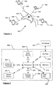
- the Global Positioning System of Figure 1 and the like are used for a variety of purposes.
- the GPS is a satellite-radio based navigation system capable of determining continuous position, velocity, time, and in some instances direction information for an unlimited number of users.
- NAVSTAR the GPS incorporates a plurality of satellites which orbit the earth in extremely precise orbits. Based on these precise orbits, GPS satellites can relay their location, as GPS data, to any number of receiving units.
- Global Positioning systems could be used, such as GLOSNASS, the European Galileo positioning system, COMPASS positioning system or IRNSS (Indian Regional Navigational Satellite System).
- the GPS system is implemented when a device, specially equipped to receive GPS data, begins scanning radio frequencies for GPS satellite signals. Upon receiving a radio signal from a GPS satellite, the device determines the precise location of that satellite via one of a plurality of different conventional methods. The device will continue scanning, in most instances, for signals until it has acquired at least three different satellite signals (noting that position is not normally, but can be determined, with only two signals using other triangulation techniques). Implementing geometric triangulation, the receiver utilizes the three known positions to determine its own two-dimensional position relative to the satellites. This can be done in a known manner. Additionally, acquiring a fourth satellite signal allows the receiving device to calculate its three dimensional position by the same geometrical calculation in a known manner. The position and velocity data can be updated in real time on a continuous basis by an unlimited number of users.
- the GPS system 100 comprises a plurality of satellites 102 orbiting about the earth 104.
- a GPS receiver 106 receives GPS data as spread spectrum GPS satellite data signals 108 from a number of the plurality of satellites 102.
- the spread spectrum data signals 108 are continuously transmitted from each satellite 102, the spread spectrum data signals 108 transmitted each comprise a data stream including information identifying a particular satellite 102 from which the data stream originates.
- the GPS receiver 106 generally requires spread spectrum data signals 108 from at least three satellites 102 in order to be able to calculate a two-dimensional position. Receipt of a fourth spread spectrum data signal enables the GPS receiver 106 to calculate, using a known technique, a three-dimensional position.
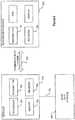
- a navigation device 200 (ie a PND) comprising or coupled to the GPS receiver device 106, is capable of establishing a data session, if required, with network hardware of a "mobile" or telecommunications network via a mobile device (not shown), for example a mobile telephone, PDA, and/or any device with mobile telephone technology, in order to establish a digital connection, for example a digital connection via known Bluetooth technology.
- a mobile device for example a mobile telephone, PDA, and/or any device with mobile telephone technology
- the mobile device can establish a network connection (through the Internet for example) with a server 150.
- a "mobile” network connection can be established between the navigation device 200 (which can be, and often times is, mobile as it travels alone and/or in a vehicle) and the server 150 to provide a "real-time” or at least very “up to date” gateway for information.
- the establishing of the network connection between the mobile device (via a service provider) and another device such as the server 150, using the Internet for example, can be done in a known manner.
- any number of appropriate data communications protocols can be employed, for example the TCP/IP layered protocol.
- the mobile device can utilize any number of communication standards such as CDMA2000, GSM, IEEE 802.11 a/b/c/g/n, etc.
- the Internet connection may be utilised, which can be achieved via data connection, via a mobile phone or mobile phone technology within the navigation device 200 for example.
- the navigation device 200 may, of course, include its own mobile telephone technology within the navigation device 200 itself (including an antenna for example, or optionally using the internal antenna of the navigation device 200).
- the mobile phone technology within the navigation device 200 can include internal components, and/or can include an insertable card (e.g. Subscriber Identity Module (SIM) card), complete with necessary mobile phone technology and/or an antenna for example.
- SIM Subscriber Identity Module
- mobile phone technology within the navigation device 200 can similarly establish a network connection between the navigation device 200 and the server 150, via the Internet for example, in a manner similar to that of any mobile device.
- a Bluetooth enabled navigation device may be used to work correctly with the ever changing spectrum of mobile phone models, manufacturers, etc., model/manufacturer specific settings may be stored on the navigation device 200 for example. The data stored for this information can be updated.
- the navigation device 200 is depicted as being in communication with the server 150 via a generic communications channel 152 that can be implemented by any of a number of different arrangements.
- the communication channel 152 generically represents the propagating medium or path that connects the navigation device 200 and the server 150.
- the server 150 and the navigation device 200 can communicate when a connection via the communications channel 152 is established between the server 150 and the navigation device 200 (noting that such a connection can be a data connection via mobile device, a direct connection via personal computer via the Internet, etc.).
- the communication channel 152 is not limited to a particular communication technology. Additionally, the communication channel 152 is not limited to a single communication technology; that is, the channel 152 may include several communication links that use a variety of technology. For example, the communication channel 152 can be adapted to provide a path for electrical, optical, and/or electromagnetic communications, etc. As such, the communication channel 152 includes, but is not limited to, one or a combination of the following: electric circuits, electrical conductors such as wires and coaxial cables, fibre optic cables, converters, radio-frequency (RF) waves, the atmosphere, free space, etc. Furthermore, the communication channel 152 can include intermediate devices such as routers, repeaters, buffers, transmitters, and receivers, for example.
- RF radio-frequency
- the communication channel 152 includes telephone and computer networks. Furthermore, the communication channel 152 may be capable of accommodating wireless communication, for example, infrared communications, radio frequency communications, such as microwave frequency communications, etc. Additionally, the communication channel 152 can accommodate satellite communication.
- the communication signals transmitted through the communication channel 152 include, but are not limited to, signals as may be required or desired for given communication technology.
- the signals may be adapted to be used in cellular communication technology such as Time Division Multiple Access (TDMA), Frequency Division Multiple Access (FDMA), Code Division Multiple Access (CDMA), Global System for Mobile Communications (GSM), General Packet Radio Service (GPRS), etc.
- TDMA Time Division Multiple Access
- FDMA Frequency Division Multiple Access
- CDMA Code Division Multiple Access
- GSM Global System for Mobile Communications
- GPRS General Packet Radio Service
- Both digital and analogue signals can be transmitted through the communication channel 152.
- These signals may be modulated, encrypted and/or compressed signals as may be desirable for the communication technology.
- the server 150 includes, in addition to other components which may not be illustrated, a processor 154 operatively connected to a memory 156 and further operatively connected, via a wired or wireless connection 158, to a mass data storage device 160.
- the mass storage device 160 contains a store of navigation data and map information, and can again be a separate device from the server 150 or can be incorporated into the server 150.
- the processor 154 is further operatively connected to transmitter 162 and receiver 164, to transmit and receive information to and from navigation device 200 via communications channel 152.
- the signals sent and received may include data, communication, and/or other propagated signals.
- the transmitter 162 and receiver 164 may be selected or designed according to the communications requirement and communication technology used in the communication design for the navigation system 200. Further, it should be noted that the functions of transmitter 162 and receiver 164 may be combined into a single transceiver.
- the navigation device 200 can be arranged to communicate with the server 150 through communications channel 152, using transmitter 166 and receiver 168 to send and receive signals and/or data through the communications channel 152, noting that these devices can further be used to communicate with devices other than server 150.
- the transmitter 166 and receiver 168 are selected or designed according to communication requirements and communication technology used in the communication design for the navigation device 200 and the functions of the transmitter 166 and receiver 168 may be combined into a single transceiver as described above in relation to Figure 2 .
- the navigation device 200 comprises other hardware and/or functional parts, which will be described later herein in further detail.
- Software stored in server memory 156 provides instructions for the processor 154 and allows the server 150 to provide services to the navigation device 200.
- One service provided by the server 150 involves processing requests from the navigation device 200 and transmitting navigation data from the mass data storage 160 to the navigation device 200.
- Another service that can be provided by the server 150 includes processing the navigation data using various algorithms for a desired application and sending the results of these calculations to the navigation device 200.
- the server 150 constitutes a remote source of data accessible by the navigation device 200 via a wireless channel.
- the server 150 may include a network server located on a local area network (LAN), wide area network (WAN), virtual private network (VPN), etc.
- LAN local area network
- WAN wide area network
- VPN virtual private network
- the server 150 may include a personal computer such as a desktop or laptop computer, and the communication channel 152 may be a cable connected between the personal computer and the navigation device 200.
- a personal computer may be connected between the navigation device 200 and the server 150 to establish an Internet connection between the server 150 and the navigation device 200.
- the navigation device 200 may be provided with information from the server 150 via information downloads which may be updated automatically, from time to time, or upon a user connecting the navigation device 200 to the server 150 and/or may be more dynamic upon a more constant or frequent connection being made between the server 150 and navigation device 200 via a wireless mobile connection device and TCP/IP connection for example.
- the processor 154 in the server 150 may be used to handle the bulk of processing needs, however, a processor (not shown in Figure 2 ) of the navigation device 200 can also handle much processing and calculation, oftentimes independent of a connection to a server 150.
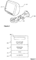
- the block diagram of the navigation device 200 is not inclusive of all components of the navigation device, but is only representative of many example components.
- the navigation device 200 is located within a housing (not shown).
- the navigation device 200 includes processing circuitry comprising, for example, the processor 202 mentioned above, the processor 202 being coupled to an input device 204 and a display device, for example a display screen 206.
- a display device for example a display screen 206.
- the input device 204 represents any number of input devices, including a keyboard device, voice input device, touch panel and/or any other known input device utilised to input information.
- the display screen 206 can include any type of display screen such as a Liquid Crystal Display (LCD), for example.
- LCD Liquid Crystal Display
- one aspect of the input device 204, the touch panel, and the display screen 206 are integrated so as to provide an integrated input and display device, including a touchpad or touchscreen input 250 ( Figure 4 ) to enable both input of information (via direct input, menu selection, etc.) and display of information through the touch panel screen so that a user need only touch a portion of the display screen 206 to select one of a plurality of display choices or to activate one of a plurality of virtual or "soft" buttons.
- the processor 202 supports a Graphical User Interface (GUI) that operates in conjunction with the touchscreen.
- GUI Graphical User Interface
- the processor 202 is operatively connected to and capable of receiving input information from input device 204 via a connection 210, and operatively connected to at least one of the display screen 206 and the output device 208, via respective output connections 212, to output information thereto.
- the navigation device 200 may include an output device 208, for example an audible output device (e.g. a loudspeaker).
- an audible output device e.g. a loudspeaker
- input device 204 can include a microphone and software for receiving input voice commands as well.
- the navigation device 200 can also include any additional input device 204 and/or any additional output device, such as audio input/output devices for example.
- the processor 202 is operatively connected to memory 214 via connection 216 and is further adapted to receive/send information from/to input/output (I/O) ports 218 via connection 220, wherein the I/O port 218 is connectible to an I/O device 222 external to the navigation device 200.
- the external I/O device 222 may include, but is not limited to an external listening device, such as an earpiece for example.
- connection to I/O device 222 can further be a wired or wireless connection to any other external device such as a car stereo unit for hands-free operation and/or for voice activated operation for example, for connection to an earpiece or headphones, and/or for connection to a mobile telephone for example, wherein the mobile telephone connection can be used to establish a data connection between the navigation device 200 and the Internet or any other network for example, and/or to establish a connection to a server via the Internet or some other network for example.
- any other external device such as a car stereo unit for hands-free operation and/or for voice activated operation for example, for connection to an earpiece or headphones, and/or for connection to a mobile telephone for example
- the mobile telephone connection can be used to establish a data connection between the navigation device 200 and the Internet or any other network for example, and/or to establish a connection to a server via the Internet or some other network for example.
- the memory 214 of the navigation device 200 comprises a portion of non-volatile memory (for example to store program code) and a portion of volatile memory (for example to store data as the program code is executed).
- the navigation device also comprises a port 228, which communicates with the processor 202 via connection 230, to allow a removable memory card (commonly referred to as a card) to be added to the device 200.
- a removable memory card commonly referred to as a card
- the port is arranged to allow an SD (Secure Digital) card to be added.
- the port may allow other formats of memory to be connected (such as Compact Flash (CF) cards, Memory Sticks TM , xD memory cards, USB (Universal Serial Bus) Flash drives, MMC (MultiMedia) cards, SmartMedia cards, Microdrives, or the like).
- CF Compact Flash
- Memory Sticks TM Memory Sticks
- xD memory cards xD memory cards
- USB Universal Serial Bus
- MMC MultiMedia cards
- SmartMedia cards SmartMedia cards
- Microdrives or the like.
- Figure 3 further illustrates an operative connection between the processor 202 and an antenna/receiver 224 via connection 226, wherein the antenna/receiver 224 can be a GPS antenna/receiver for example and as such would function as the GPS receiver 106 of Figure 1 .
- the antenna and receiver designated by reference numeral 224 are combined schematically for illustration, but that the antenna and receiver may be separately located components, and that the antenna may be a GPS patch antenna or helical antenna for example.
- the electronic components shown in Figure 3 are powered by one or more power sources (not shown) in a conventional manner.
- power sources may include an internal battery and/or a input for a low voltage DC supply or any other suitable arrangment.
- power sources may include an internal battery and/or a input for a low voltage DC supply or any other suitable arrangment.
- different configurations of the components shown in Figure 3 are contemplated.
- the components shown in Figure 3 may be in communication with one another via wired and/or wireless connections and the like.
- the navigation device 200 described herein can be a portable or handheld navigation device 200.
- the portable or handheld navigation device 200 of Figure 3 can be connected or "docked" in a known manner to a vehicle such as a bicycle, a motorbike, a car or a boat for example. Such a navigation device 200 is then removable from the docked location for portable or handheld navigation use. Indeed, in other embodiments, the device 200 may be arranged to be handheld to allow for navigation of a user.
- the navigation device 200 may be a unit that includes the integrated input and display device 206 and the other components of Figure 2 (including, but not limited to, the internal GPS receiver 224, the processor 202, a power supply (not shown), memory systems 214, etc.).
- the navigation device 200 may sit on an arm 252, which itself may be secured to a vehicle dashboard/window/etc. using a suction cup 254.
- This arm 252 is one example of a docking station to which the navigation device 200 can be docked.
- the navigation device 200 can be docked or otherwise connected to the arm 252 of the docking station by snap connecting the navigation device 200 to the arm 252 for example.
- the navigation device 200 may then be rotatable on the arm 252.
- a button (not shown) on the navigation device 200 may be pressed, for example.
- Other equally suitable arrangements for coupling and decoupling the navigation device 200 to a docking station are well known to persons of ordinary skill in the art.
- the processor 202 and memory 214 cooperate to support a BIOS (Basic Input/Output System) 282 that functions as an interface between functional hardware components 280 of the navigation device 200 and the software executed by the device.
- BIOS Basic Input/Output System
- the processor 202 then loads an operating system 284 from the memory 214, which provides an environment in which application software 286 (implementing some or all of the described route planning and navigation functionality) can run.
- the application software 286 provides an operational environment including the Graphical User Interface (GUI) that supports core functions of the navigation device, for example map viewing, route planning, navigation functions and any other functions associated therewith.
- GUI Graphical User Interface
- part of the application software 286 comprises a view generation module 288.
- the processor 202 of the navigation device is programmed to receive GPS data received by the antenna 224 and, from time to time, to store that GPS data, together with a time stamp of when the GPS data was received, within the memory 214 to build up a record of the location of the navigation device.
- Each data record so-stored may be thought of as a GPS fix; ie it is a fix of the location of the navigation device and comprises a latitude, a longitude, a time stamp and an accuracy report.
- the data is stored substantially on a periodic basis which is for example every 5 seconds.
- a periodic basis which is for example every 5 seconds.
- the resolution might be substantially every: 1 second, 10 seconds, 15 seconds, 20 seconds, 30 seconds, 45 seconds, 1 minute, 2.5 minutes (or indeed, any period in between these periods).
- the quality of the captured data reduces as the period increases and whilst the degree of degradation will at least in part be dependent upon the speed at which the navigation device 200 was moving a period of roughly 15 seconds may provide a suitable upper limit.
- the navigation device 200 Whilst the navigation device 200 is generally arranged to build up a record of its whereabouts, some embodiments, do not record data for a predetermined period and/or distance at the start or end of a journey. Such an arrangement helps to protect the privacy of the user of the navigation device 200 since it is likely to protect the location of his/her home and other frequented destinations. For example, the navigation device 200 may be arranged not to store data for roughly the first 5 minutes of a journey and/or for roughly the first mile of a journey.
- the GPS may not be stored on a periodic basis but may be stored within the memory when a predetermined event occurs.
- the processor 202 may be programmed to store the GPS data when the device passes a road junction, a change of road segment, or other such event.
- the processor 202 is arranged, from time to time, to upload the record of the whereabouts of the device 200 (ie the GPS data and the time stamp) to the server 150.
- the uploading of the data occurs on a periodic basis which may for example be once every 24hours.
- the skilled person will appreciate that other periods are possible and may be substantially any of the following periods: 15 minutes, 30 minutes, hourly, every 2 hours, every 5 hours, every 12 hours, every 2 days, weekly, or any time in between these.
- the processor 202 may be arranged to upload the record of the whereabouts on a substantially real time basis, although this may inevitably mean that data is in fact transmitted from time to time with a relatively short period between the transmissions and as such may be more correctly thought of as being pseudo real time.
- the navigation device may be arranged to buffer the GPS fixes within the memory 214 and/or on a card inserted in the port 228 and to transmit these when a predetermined number have been stored. This predetermined number may be on the order of 20, 36, 100, 200 or any number in between. The skilled person will appreciate that the predetermined number is in part governed by the size of the memory 214 / card within the port 228.
- the processor 202 may be arranged to upload the record to the server 152 when a communication channel 152 is created. This may for example, be when the navigation device 200 is connected to a user's computer. Again, in such embodiments, the navigation device may be arranged to buffer the GPS fixes within the memory 214 or on a card inserted in the port 228. Should the memory 214 or card inserted in the port 228 become full of GPS fixes the navigation device may be arranged to deleted the oldest GPS fixes and as such it may be thought of as a First in First Out (FIFO) buffer.
- FIFO First in First Out
- the record of the whereabouts comprises one or more traces with each trace representing the movement of that navigation device 200 within a 24 hour period.
- Each 24 is arranged to coincide with a calendar day but in other embodiments, this need not be the case.
- a user of a navigation device 200 gives his/her consent for the record of the devices whereabouts to be uploaded to the server 150. If no consent is given then no record is uploaded to the server 150.
- the navigation device itself, and/or a computer to which the navigation device is connected may be arranged to ask the user for his/her consent to such use of the record of whereabouts.
- the server 150 is arranged to receive the record of the whereabouts of the device and to store this within the mass data storage 160 for processing. Thus, as time passes the mass data storage 160 accumulates a plurality of records of the whereabouts of navigation devices 200 which have uploaded data.
- the mass data storage 160 also contains map data.
- map data provides information about the location of road segments, points of interest and other such information that is generally found on map.
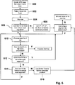
- the server 150 is arranged to perform a map matching function between the map data and the GPS fixes contained within the records of the whereabouts that have been received and such a process is described in relation to Figure 6 .
- map matching may be performed in a so-called real time manner; ie as the records of whereabouts are received or may be performed a time later after the records of the whereabouts have been recalled from the mass data storage 160.
- each GPS trace (ie a 24hour period of GPS data) is divided 600 into one or more trips with each trip representing a single journey of the navigation device 200 which are subsequently stored for later processing.
- GPS fixes whose accuracy report received from the navigation device is not sufficiently high are rejected 602.
- a fix may be rejected if the accuracy report indicates that the signals from less than three satellites 102 were being received by the navigation device 200 in relation to that GPS fix.
- each trip is clipped 604 when the reported time between fixes goes above a threshold value.
- Each trip that passes this pre-processing stage is passed to be map matched.
- a clipped trip is a trip in which the there is a time period between consecutive GPS fixes of greater than a predetermined time. As such, it might be inferred that the vehicle has remained stationary and as such it should be considered a first trip has ended and a second trip has commenced. Thus, a clipped trip becomes two separate trips.
- the predetermined time is roughly 3 minutes.
- the gap may be any other suitable time, such as roughly any of the following: 15 seconds, 30 seconds, 1 minute, 90 seconds, 2 minutes, 5 minutes, 10 minutes or any time in between these.
- data may in some embodiments, be rejected in later processing.
- Such an embodiment can be useful in that it can remove data relating to so-called stop-start traffic which occurs after incidents such as a crash or the like which may leave remaining data more representative of steady state traffic flow.
- Each trip is taken in turn and fixes within that trip are matched to a map from within the map data.
- Each map comprises a plurality of road segments along which it is possible to travel with each segment being represented within the map as a straight vector.
- the program code running on the processor 154 of the server 150 provides a map matcher that is arranged to step over the or each fix in the trip that is being processed until it finds a fix which lies within a segment or is sufficiently close to a segment in order for it to be assumed to have occurred on that segment (ie it is within a distance threshold of the segment). This threshold allows for less than 100% GPS accuracy and the compressing effect of splitting the road into a set of straight vectors.
- Each trip has an initial fix (ie the first fix within the trip) which is harder to associate with a segment than other fixes within the trip since there are no segments that have already identified which can be used to constrain the selection of the segments. If, for this first fix, multiple segments are within the threshold 606, then the algorithm looks to the next GPS fix (ie the 2nd fix) within the trip and generates a set of roots from those multiple segments based on the possible travel as a function of the distance between the 2 fixes (ie between the 1st and 2nd fixes). If the 2nd fix does not lead to a unique candidate segment for the 1st fix, then the algorithm moves to the 3rd fix within the trip and again generates and compares the possible routes to try and provide a unique candidate for the first fix 608. This process may continue until the remaining GPS fixes within a trip have been processed.
- An advantage of such an embodiment is that although any one first fix in isolation may be near multiple segments, and in isolation these segments can not be distinguished between, it becomes possible using the further travel (ie the 2nd and 3rd fixes) to determine the identity of the segment with which the first fix is associated. Thus, a fist segment for a trip is determined by the map matcher.
- the subsequent fixes of a trip are processed 610 to determine if they are within the distance threshold of the segment, and the map matcher is arranged to associate that segment with each of the fixes that lie within the distance threshold.
- the map matcher process a fix that is outwith the distance threshold it is arranged to generate a new set of candidate segments for that fix.
- the next segment is one which is connected to the end of the one which has just been processed. These neighbouring segments are obtained by the map matcher from the underlying map data.
- the map matcher fails to identify a segment for a given fix that follows on from the previous segment, either because there are no segments within a threshold, or it cannot uniquely identify a single segment, then the map matcher is arranged to step through subsequent fixes 616 in order to further constrain the journey until it can identify a segment that is a unique match. That is, if the nth fix cannot be uniquely associated with a segment the nth + I segment is used to further constrain the identification of a segment. If the nth + 1 fix does not produce a unique segment then the nth + 2 fix is used. In some embodiments, this process may carry on until the a unique segment is identified or all of the GPS fixes with a trip have been processed.
- the map matcher is arranged to try and uniquely identify segments; in the embodiment being described, it does not attempt to create a continuous route, only to try and match segments to fixes. In other embodiments, it may be desirable to try and have the map matcher generate continuous routes.
- the map matcher further processes these road segments and assigns, from the GPS fixes, an ingress time and also a transit time for that segment. These assigned times are stored within the mass data storage 160 for later processing. It may well be that a plurality of GPS fixes are stored for each road segment. However, regardless of how many GPS fixes are associated with each segment, the ingress time ,GPS fixes and the length of the segment (which in this embodiment is stored within the map data) are used to calculate the average speed for that segment of road. This average speed is then stored within the mass data storage 160 associated with the relevant assigned times and that segment. Information relating to a speed of traffic flow on a road segment and assigned to a road segment may be thought of as being speed data for that road segment.
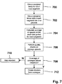
- the server 150 is further arranged to run averaging program code on the processor 154 to provide an averager which processes the assigned times to generate one or more averages therefrom as described below.
- the averaging process used in this embodiment is now described in relation to Figure 7 .
- the averager groups the average speeds for each road segment on the map being processed. Within the grouping for each road segment, the averager is further arranged to group the average speeds within a set of predetermined time periods 702. Thus, average speeds which occur within the same time period (eg between 8.00am and 8.59am) are grouped together for further analysis.
- the time periods are one hour durations but this need not be the case and the skilled person will appreciate, from the following description, that as the length of the time period decreases the resolution of the data is increased but storage requirements are increased.
- Other suitable time periods might substantially any of the following: 1 minute, 5 minutes, 10 minutes, 15 minutes, 30 min, 2 hours, 6 hours, 12 hours, or any time in between these times.
- average speeds are stored in a time local to the area covered by the map being processed rather than a centralised time. Such a method is convenient as it provides a natural basis for traffic related issues.
- the average speed is only added to the group for the predetermined period if the average speed falls within a predetermined range.
- the method excludes speeds which exceed a maximum predetermined threshold (which may be roughly 180km/h) and further, the method excludes speeds which fall below a predetermined amount of the average speed for that segment in that predetermined time period (which may for example be 2km/h).
- a maximum predetermined threshold which may be roughly 180km/h
- the method excludes speeds which fall below a predetermined amount of the average speed for that segment in that predetermined time period (which may for example be 2km/h).
- speeds which are well below the average speed for that segment in that time may well be associated with a problem in the traffic flow for that segment, such as a traffic jam or the like.
- the max permitted speed may be set as the speed limit for that segment of road, but the skilled person will appreciate that such information can be inaccurate in map data that is being processed and also that the speed limit for a segment of road may in fact not give an accurate indication of traffic conditions.
- an average speed is calculated for each road segment for each predetermined time period. For example, all of the speeds within the 8.00am to 8.59am time period, for each segment of road are averaged.
- each segment of road on the map 24 average speeds; an average speed for each hour long predetermined time period. It will be appreciated that if a different duration of time period is used then there will be a different number of average speeds. It will be further appreciated that, in fact, not all road segments will necessarily have an average speed assigned thereto for every time period since some roads may be traversed infrequently, particularly at unsociable times such as the early hours of the morning.
- quality checks are performed 706. In this embodiment, this check ensures that more than a predetermined number of assigned times were used to generate average speed per segment. If this is not the case then that average speed per segment is rejected for further processing leaving a gap for that segment at one or more time periods. In some embodiments, the average is rejected if there are fewer than 5 values that went to make up that average. Other embodiments, may of course use different values, such as 2, 3, 4, 6, 7, 8, 10, 20 or more or any value in between these.
- the set of averages for any given road segment may be thought of as a measured speed profile for that road segment.
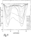
- step 708 an assessment is made as to the overall coverage of average speeds per road segment. If the coverage of trustworthy averages is high enough then the map data is forwarded for further processing. However, if the coverage is below a predetermined threshold then the map is rejected from further consideration 710. Acceptable maps are passed for cluster formation as is described in relation to Figure 8 .
- Such cluster formation aims to extract regular speed profiles in an automatic or semi-automatic manner; as will be discussed later, data compression, which may be significant, can be achieved if it is assumed that roads of a similar class may have a similar speed profile. For example, the speed at 10am on a Sunday morning for a first segment of road may be similar to the speed at the same time for a second segment of road. If this similarity for those segments of road is repeated for other times then the speed profile for the first and second segments may be considered to be represented by the same speed profile of the second segment.
- the clustering as now defined aims to locate such similarities. Normalisation of speed profiles, as discussed below, may also allow a speed profile to be used for roads of a different class.
- the measured speed profile is further processed in order to amalgamate the night-time time periods.
- the average speeds between 9pm and 5am ie 8 time periods
- this night-time average is used for each of 8 time periods; that is the measured speed profile is modified to replace a portion thereof with modified values for the average speeds for one or more predetermined time periods which comprises using an average of the speed averages to be replaced as the modified value for each of the predetermined time periods.
- each speed profile has a flat speed profile between the hours of 9pm and 8am which may be termed the free flow speed of that road segment.
- the free flow speed represents the speed at which a vehicle, generally a car, travels along the road and it is often the case that the free flow speed is different from the speed limit for that road segment.
- the free flow speed may also be roughly the same as the speed limit for that road segment.
- a first step 800 and in order to limit the number of clusters the measured speed profiles are normalised.
- Such normalisation can be performed according to a number of criteria.
- normalisation occurs according to the free flow speed that has been calculated for the segment of road with which the average is associated.
- the average speed per road segment that is passed to the clustering algorithm has a value of between 0 and 1.
- Such a method can aid further data compression since it can make the resulting cluster-generated speed profile independent of the type of road and as such it becomes possible to use the same set of speed profiles for road segments having any road type.
- the cluster generated speed profiles may also be thought of as generated speed profiles.
- Use of the free-flow speeds during the night time period may reduce the dimension of the cluster formation since it may be possible to neglect night time speed values.
- the average speed or the speed limit of a road segment may be used as a further criteria against which to perform the normalisation.
- days showing a similar traffic behavior can be grouped together by processing by a clustering algorithm. If the expected traffic behavior is different the cluster formation should run independently.
- An input parameter to the clustering algorithm is the number of desired clusters and a typical range is 10-70 for a day of the week.
- There are known methods to approach the optimal number of clusters e.g. having some quality measures assigned and enlarging/reducing the numbers of clusters according to its trend) which may be used to determine whether the output of the clustering is acceptable.
- the clustering algorithm is run and arranged to generate around 60 clusters. In other embodiments, the algorithm may be arranged to generate more or less clusters initially. The resultant clusters are then processed to determine whether the generated clusters are satisfactory: are some of the clusters too similar (ie substantially the same)? Do any of the clusters have discontinuities therein? If there are problems with any of the clusters then the algorithm is re-run with the process aiming to generate fewer clusters than the first iteration. This iterative process is repeated until a satisfactory set of clusters is determined.
- whether the clusters are satisfactory includes a step of determining whether or not any of the cluster-generated profiles contain frequencies above a predetermined threshold. The presence of such frequencies indicates that that cluster-generated speed profile has a rate of change that is too high (ie there may be a discontinuity) and if used may result in instability, etc. within a navigation device 200 using that data to generate a route.
- Whether or not the clusters are satisfactory may also include the step of performing a comparison between at least some, and generally each, of the cluster-generated speed profiles. In one particular embodiment this may be performed by a least squares comparison.
- the cluster is performed by cluster analysis, but other class building methods might be used as well.
- a simple and efficient approach is the so-called k-means clustering algorithm.
- This non-hierarchical method normally starts with k random seeds and redistributes the class members according to a minimum error criteria based on a chosen metric. The algorithm leads to local minima only, therefore for an optimal solution it has to run multiple times. The run with the minimum error estimates gives what may be a preferred solution.
- the centroids of the final clusters form the predefined clusters.
- other clustering techniques may be used and these include hierarchical clustering and fuzzy clustering.
- Some embodiments may add further clusters 804. For example, some embodiments may add a flat line as a speed profile for road segments that have no trustworthy trend, e.g. due to low data coverage or because of traffic related issues.
- the clusters are interpolated to a variable time resolution. In one embodiment this is performed using cubic splines but other techniques are possible such as an exponential fitting function. The skilled person will also appreciate similar techniques that may be used.
- the time resolution used in the cluster analysis procedure itself is coarser than is finally desired, which may occur in order that there are a sufficient number of reliable average speed in any one predetermined time period, the time resolution can now be modified. For example, it can be modified to finer resolution to meet the requirements of the intended use. For example, it can be advantageous to have a finer resolution having a more continuous profile in place is desired to provide smoother routes which might otherwise "jump" on time boundaries if the time resolution is too coarse.
- the cluster-generated profiles are interpolated in order that they have a resolution of roughly 5min intervals, although any other period may be used. Such a period may be convenient for later processing using the cluster-generated speed profile.
- Figure 9 shows a typical output from the clustering algorithm for a map in which the input average speed values have been clustered into 16 independent cluster generated speed profiles.
- each section of road can now be referred to as having one of the 16 cluster generated speed profiles. If in other embodiments, the number of clusters is varied then the number of possible speed profiles for any one segment of road is also changed.
- a suitable set of cluster generated speed profiles has been determined - in this embodiment 16 have been generated - then these are associated with one or more maps.
- a set of speed profiles will be more accurate for the map from which they have been generated since traffic behavior may be different on roads not on that map. For example, should a map cover a single country then it may be that traffic in a different country follows slightly different patterns.
- the speed profiles may be associated with a plurality of maps. In one example, this may be appropriate if the a map covers a portion of a country and/or it may be appropriate to use the map for a plurality of countries.
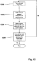
- Each road segment that is present on the map being processed is analysed and may have one of the cluster generated speed profiles (as shown in Figure 9 ) associated therewith and this process is described in relation to Figure 12 .
- the nth road segment is processed 1200.
- each road segment is represented by data within the map data providing the map.
- data representing the road segment may include an identifier which provides a reference to the speed data.
- the reference may provide a reference to a generated speed profile.
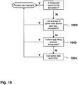
- each road segment has a speed profile associated therewith in which there is a high degree of belief (as a first step this is assessed on whether the measured speed profile is suitable).
- a fall back strategy is used to replace the measured speed profile with speed data which is likely to prove better for routing purposed when processed by a PND or other device.
- an average speed 1000 for the road segment being processed which comprises an average of all the speed data collected for that road segment is used instead of the measured speed profile. That is the data collected for each time period for each day is averaged to generate a single speed.
- This single average speed may be, in due course, mapped to the flat cluster generated speed profile (number 15 in Figure 9 ).
- Figure 9 may be thought of as showing a set of 15 generated speed profiles, each varying with respect to time, to which a 16th, roughly flat, generated speed profile (ie profile number 15 in Figure 9 ) has been added which does not vary with respect to time (or at least does not vary substantially with respect to time).
- measures may be used to measure the quality of the average. For example, in some embodiments, it may be required that the average is made up from more than a predetermined number of speeds, which may for example be roughly 10 speeds. Thresholds may be applied to the averages to ensure that they are above a minimum value (which may for example be roughly 2 km/h) and/or below a maximum value (which may for example be roughly 150 km/h). The standard deviation may also be used to determine whether the average is of a high enough quality.
- road segments may be classified according to a classification system within map data such that roads of similar characteristics are classified within the same classification. For example, maps generated by one party has 8 categories into which road segments are classified.
- the average for a given road segment is analysed to ensure that at least a predetermined percentage of roads within the classification for that road segment have provided a speed which has been used to generate the average. If this test fails then not only is the average rejected, but the gap filling procedure described next may also be omitted.
- speed profile number 15 may be used to represent any road segment having a single average speed associated therewith.
- each road segment on the map being processed is categorised as being a member of one of a predetermined number of categories 1100.
- This categorisation of each road segment need only be performed once and the resulting categorisation maintained for further road segments for which the gap-filling process is invoked.
- Other embodiments could of course re-calculate at each invocation or indeed calculate the categories on the fly.
- Table 1 Motorways 0 any motorway inside and outside city except roundabout, sliproad or parallel road 1 roundabout on motorway inside and outside city 2 sliproad on motorway inside and outside city 3 parallel road on motorwav inside and outside city International Roads 4 any international road outside city except roundabout or sliproad 5 any international road inside city except roundabout or sliproad 6 roundabout on international road outside city 7 roundabout on international road inside city 8 sliproad on international road outside city 9 sliproad on international road inside city Major Roads 10 any major roads outside city except roundabout, sliproad or parallel road 11 any major roads inside city except roundabout, sliproad or parallel road 12 roundabout on major roads outside city 13 roundabout on major roads inside city 14 sliproad on major roads 15 sliproad on major roads inside city 16 parallel road on major roads inside and outside city Secondary Roads 17 any secondary roads outside city except roundabout, sliproad or parallel road 18 any secondary roads inside
- a category average speed is calculated for each one of the predetermined categories 1102, in this case 40 categories.
- the category average that is generated is a single figure per category and in order to achieve this the average speed for each predetermined time period is averaged using any suitable averaging technique as mentioned herein. Again, the skilled person will appreciate that this step may only need to be performed once and the category average speed maintained for future invocations of the gap-filling process.
- table 2 may well vary in other embodiments and are shown as an example only.
- replacement values used in table 3 may well vary in other embodiments, depending upon the area covered by the map, the party that generated the map data, etc.
- the average for the classification should lie above a minimum threshold and below a maximum threshold which are computed in the following way, with min and max are pseudo code minimum and maximum functions:
- an average speed may have been generated, based upon road segments within the same category from the predetermined 40.
- the gap-filling process might still fail (ie no average is generated which passes the quality checks).
- the speed associated with that road segment is set to be the speed that has been provided by the map data supplier according to Functional Road Class (FRC).
- the functional road class may for example comprise roughly 8 categories, although this might differ between map data suppliers. That is, the free flow speed is set to a value according to the FRC and the cluster generated speed profile is set to be, in this embodiment, profile number 15.
- the speed profile (whether a measured speed profile or an average inserted by gap filling) associated with a road segment is now mapped to one of the cluster generated speed profiles to generate the map data which can be used by navigation devices such as PND's. This may be performed regardless of whether the speed information is a measured speed profile or an average in view of the presence of the flat cluster generated speed profile number 15.
- step 1210 the speed profile is compared, using a least squares comparison, with each of the speed profiles in the set of cluster generated speed profiles. After these 16 comparisons have been made it is possible to determine which speed profile from the set of 16 is closest to the speed profile associated with the road segment and in step 1220 a reference to the cluster generated speed profile that is deemed to be closest is stored in the map data for that road segment. Also stored in the map data in relation to that road segment is the free flow speed for that road segment which has been calculated earlier.
- the average speed information can be thought of as comprising an approximation to the daily hourly average between the hours of 9am to 5pm.
- the average speed data may be thought of as being an average speed which is averaged across all time periods.
- a final check is made to see if a sufficient number of road segments have a measured speed profile associated with them (as opposed to an average that has been inserted instead of a measured speed profile). If this check is not passed then the whole map is rejected and not released for use.
- the total length of road segments is calculated for each Functional Road Class (FRC).
- the FRC's are related to the 40 categories listed in table 2 as shown in table 5 below.
- the length of road segment within each FRC with average speed data assigned thereto should be above the threshold percentage of the total road length within the FRC as shown in table 5.
- table 5. FRC (Functional Road Class) Description FRC Minimum required length coverage [%] Motorways 0 60 International roads 1 50 Major roads 2 40 Secondary roads 3 30 Connecting roads 4 18 Important local roads 5 12 Local roads 6 2 Destination roads 7 0
- a first fall back strategy (should the measured speed profile been deemed unacceptable) may be to aggregate the same predetermined time periods for each day; ie the predetermined time period from a first day are added to that period for each of the other days and then the resulting aggregated speed profile is used for each day rather than using a measured speed profile for each separate day. Therefore, in such an embodiment, a weekly speed profile is generated by adding the same time periods for each of the days Monday to Friday and a weekend speed profile is generated by adding the same time periods for each of Saturday and Sunday. It will be appreciated that traffic flow on the weekend may well be different to traffic flow on week days.
- Such aggregated speed profile may then be checked to see if passes quality criteria before using other fall back strategies if it is not acceptable. These checks may be made using the same, or at least similar, criteria to those used to assess the measured speed profiles. If the aggregation of the data has improved the quality so that both the weekly and weekend speed profiles pass the quality check then these speed profiles are used for that road segment.
- an apparatus provided to execute a method as described herein may comprise hardware, software, firmware or any combination of two or more of these.
- GPS data has been used to refer to positioning data derived from a GPS global positioning system as for example described in relation to Figure 1 .
- Other positioning data could be processed in a manner similar to the methods as described herein.
- GPS data may be replaceable with the phrase positioning data.
- Such positioning data could for example be derived from position data derived from mobile phone operation, data received at toll barriers, data obtained from induction loops embedded in roads, data obtained from number plate recognition system or any other suitable data.
Abstract
Claims (16)
- Procédé pour améliorer des données cartographiques en utilisant des données de localisation horodatées reçues à partir d'une pluralité de dispositifs compatibles GPS, lesdites données cartographiques comprenant une pluralité de segments navigables représentant des segments d'une route navigable dans la zone couverte par la carte, chaque segment possédant des informations de vitesse associées à celui-ci ou étant immédiatement dérivables d'un attribut de celui-ci spécifiant une catégorie de route représentée par ledit segment, le procédé comprenant :i. le traitement des données de localisation, en utilisant des données cartographiques et l'horodatage, pour dériver des données de vitesse mesurée et un temps attribué qui sont associés à la plupart, voire la totalité, des segments navigables au sein desdites données cartographiques,ii. la catégorisation de ces données de vitesse mesurée en une pluralité de périodes prédéterminées pour lesdits segments navigables, etiii. la réalisation de la moyenne des données de vitesse mesurée au sein de chaque période prédéterminée afin de générer un profil de vitesse mesurée pour la plupart, voire la totalité, desdits segments navigables,
caractérisé en ce que le procédé comprend les étapes supplémentaires suivantes :iv. la mise en grappe des profils de vitesse mesurée de segments possédant des profils de vitesse similaires en identifiant des similarités entre les profils de vitesse mesurées afin de fournir un nombre de profils de vitesse générés par grappe indépendants de catégories de route, etv. l'association des profils de vitesse générés par grappe à des données cartographiques. - Procédé selon la revendication 1, qui comprend le traitement des données de vitesse mesurée avant qu'elles soient catégorisées en la pluralité de périodes prédéterminées afin de rejeter des données de vitesse mesurée qui sont en dehors de critères prédéterminés.
- Procédé selon la revendication 2, dans lequel des données de vitesse mesurée sont rejetées si les données de vitesse mesurée sont au moins : inférieures à une vitesse prédéterminée, et, supérieures à une vitesse prédéterminée.
- Procédé selon une quelconque des revendications 1 à 3, dans lequel les moyennes calculées pour chaque période prédéterminée sont analysées pour déterminer si elles sont acceptables en s'assurant que l'écart type de la moyenne satisfait des critères prédéterminés.
- Procédé selon la revendication 1, dans lequel les dispositifs compatibles GPS sont des dispositifs de navigation.
- Procédé selon la revendication 5, dans lequel les données de localisation sont traitées pour générer des données de trajet représentant un trajet individuel pour un dispositif de navigation.
- Procédé selon une quelconque revendication précédente, dans lequel chacun des profils de vitesse mesurée varie par rapport au temps.
- Procédé selon la revendication 7, qui génère au moins un profil de vitesse mesurée supplémentaire qui ne varie pas par rapport au temps.
- Procédé selon la revendication 8, dans lequel le profil de vitesse mesurée ne variant pas avec le temps est dérivé d'une moyenne des données de vitesse mesurée durant une période nocturne et est équivalent à une vitesse de flux libre sur le segment navigable pour lequel il est généré.
- Procédé selon la revendication 9, dans lequel la période nocturne est entre 21h00 et 5h00.
- Procédé selon une quelconque revendication précédente, dans lequel les périodes prédéterminées comprennent 16 périodes d'1 heure chacune entre 5h00 et 21 h00.
- Procédé selon une quelconque revendication précédente, qui comprend la génération d'une carte constituée par les données cartographiques.
- Procédé selon une quelconque revendication précédente, dans lequel la mise en grappe entraîne la génération de 16 profils de vitesse générés par grappe indépendants de catégories de route qui peuvent être associés à un quelconque des segments navigables au sein des données cartographiques.
- Données cartographiques résultant de la réalisation des procédés selon une quelconque des revendications 1 à 13, et dans lesquelles l'association de profils de vitesse générés par grappe auxdites données cartographiques revient à mémoriser, pour au moins un segment, une référence au profil de vitesse généré par grappe qui est estimé être le plus similaire à un profil de vitesse mesurée pour ce segment.
- Support lisible par machine contenant des instructions qui, lorsqu'elles sont traitées par une machine, entraînent la réalisation, par cette machine, de ce qui suit :i. le procédé selon une quelconque des revendications 1 à 13, ouiii. le maintien des données cartographiques selon la revendication 14.
- Dispositif de navigation sur lequel sont fournies les données cartographiques selon la revendication 14, et qui, en tant que partie d'un procédé de planification de route, utilise au moins certaines données de profil de vitesse générées par grappe associées à des segments navigables faisant partie de la route planifiée.
Applications Claiming Priority (3)
| Application Number | Priority Date | Filing Date | Title |
|---|---|---|---|
| US99605007P | 2007-10-26 | 2007-10-26 | |
| US99605207P | 2007-10-26 | 2007-10-26 | |
| PCT/EP2008/064319 WO2009053407A1 (fr) | 2007-10-26 | 2008-10-22 | Procédé pour traiter des données de localisation |
Publications (2)
| Publication Number | Publication Date |
|---|---|
| EP2203717A1 EP2203717A1 (fr) | 2010-07-07 |
| EP2203717B1 true EP2203717B1 (fr) | 2012-05-16 |
Family
ID=40149835
Family Applications (8)
| Application Number | Title | Priority Date | Filing Date |
|---|---|---|---|
| EP08843085.5A Active EP2203718B1 (fr) | 2007-10-26 | 2008-10-22 | Procédé pour traiter des données de localisation |
| EP08842327A Withdrawn EP2203716A1 (fr) | 2007-10-26 | 2008-10-22 | Procédé pour traiter des données de localisation |
| EP15177376.9A Active EP2963389B1 (fr) | 2007-10-26 | 2008-10-22 | Dispositif de navigation utilisant des profils de vitesse normalisés |
| EP08841337A Withdrawn EP2203713A1 (fr) | 2007-10-26 | 2008-10-22 | Procédé pour traiter des données de localisation |
| EP12199258A Withdrawn EP2573519A1 (fr) | 2007-10-26 | 2008-10-22 | Procédé de traitement de données de positionnement |
| EP08842961A Active EP2203717B1 (fr) | 2007-10-26 | 2008-10-22 | Procédé pour traiter des données de localisation |
| EP08842310A Withdrawn EP2203715A1 (fr) | 2007-10-26 | 2008-10-22 | Procédé et machine pour produire des données de carte et procédé et dispositif de navigation pour déterminer un itinéraire à l'aide des données de carte |
| EP08841951.0A Active EP2203714B1 (fr) | 2007-10-26 | 2008-10-22 | Procédé pour créer des données de carte |
Family Applications Before (5)
| Application Number | Title | Priority Date | Filing Date |
|---|---|---|---|
| EP08843085.5A Active EP2203718B1 (fr) | 2007-10-26 | 2008-10-22 | Procédé pour traiter des données de localisation |
| EP08842327A Withdrawn EP2203716A1 (fr) | 2007-10-26 | 2008-10-22 | Procédé pour traiter des données de localisation |
| EP15177376.9A Active EP2963389B1 (fr) | 2007-10-26 | 2008-10-22 | Dispositif de navigation utilisant des profils de vitesse normalisés |
| EP08841337A Withdrawn EP2203713A1 (fr) | 2007-10-26 | 2008-10-22 | Procédé pour traiter des données de localisation |
| EP12199258A Withdrawn EP2573519A1 (fr) | 2007-10-26 | 2008-10-22 | Procédé de traitement de données de positionnement |
Family Applications After (2)
| Application Number | Title | Priority Date | Filing Date |
|---|---|---|---|
| EP08842310A Withdrawn EP2203715A1 (fr) | 2007-10-26 | 2008-10-22 | Procédé et machine pour produire des données de carte et procédé et dispositif de navigation pour déterminer un itinéraire à l'aide des données de carte |
| EP08841951.0A Active EP2203714B1 (fr) | 2007-10-26 | 2008-10-22 | Procédé pour créer des données de carte |
Country Status (10)
| Country | Link |
|---|---|
| US (6) | US9297664B2 (fr) |
| EP (8) | EP2203718B1 (fr) |
| JP (10) | JP5713676B2 (fr) |
| CN (7) | CN101836080B (fr) |
| AU (6) | AU2008316530A1 (fr) |
| CA (6) | CA2703505A1 (fr) |
| ES (2) | ES2458144T3 (fr) |
| RU (5) | RU2498220C2 (fr) |
| TW (6) | TW200925557A (fr) |
| WO (6) | WO2009053410A1 (fr) |
Families Citing this family (129)
| Publication number | Priority date | Publication date | Assignee | Title |
|---|---|---|---|---|
| CN101836080B (zh) | 2007-10-26 | 2014-12-17 | 通腾科技股份有限公司 | 处理定位数据的方法 |
| US8015144B2 (en) | 2008-02-26 | 2011-09-06 | Microsoft Corporation | Learning transportation modes from raw GPS data |
| US8972177B2 (en) | 2008-02-26 | 2015-03-03 | Microsoft Technology Licensing, Llc | System for logging life experiences using geographic cues |
| US8966121B2 (en) | 2008-03-03 | 2015-02-24 | Microsoft Corporation | Client-side management of domain name information |
| GB0822893D0 (en) * | 2008-12-16 | 2009-01-21 | Tele Atlas Bv | Advanced speed profiles - Further updates |
| US9063226B2 (en) | 2009-01-14 | 2015-06-23 | Microsoft Technology Licensing, Llc | Detecting spatial outliers in a location entity dataset |
| WO2010081836A1 (fr) | 2009-01-16 | 2010-07-22 | Tele Atlas B.V. | Procédé pour calculer un trajet économe en énergie |
| IN2012DN00281A (fr) | 2009-07-09 | 2015-05-08 | Tomtom Int Bv | |
| US9109909B2 (en) | 2009-07-09 | 2015-08-18 | Tomtom International B.V. | Navigation devices |
| US20110046881A1 (en) * | 2009-08-20 | 2011-02-24 | Jeyhan Karaoguz | Personal mapping system |
| US8275649B2 (en) | 2009-09-18 | 2012-09-25 | Microsoft Corporation | Mining life pattern based on location history |
| DE112010003789T5 (de) * | 2009-09-24 | 2012-11-29 | Mitsubishi Electric Corporation | Fahrmuster-erzeugungsvorrichtung |
| US9009177B2 (en) | 2009-09-25 | 2015-04-14 | Microsoft Corporation | Recommending points of interests in a region |
| US9154560B2 (en) | 2009-10-12 | 2015-10-06 | Qualcomm Incorporated | Method and system for building annotation layers based on location aware user context information |
| US9173337B2 (en) | 2009-10-19 | 2015-11-03 | Efc Systems, Inc. | GNSS optimized control system and method |
| AU2015271869B2 (en) * | 2009-12-15 | 2017-05-25 | Here Global B.V. | Speed profile dictionary |
| US8396663B2 (en) | 2009-12-15 | 2013-03-12 | Navteq B.V. | Speed profile dictionary |
| US8805078B2 (en) * | 2010-02-08 | 2014-08-12 | Tomtom Germany Gmbh & Co. Kg | Methods for digital mapping and associated apparatus |
| US8612134B2 (en) | 2010-02-23 | 2013-12-17 | Microsoft Corporation | Mining correlation between locations using location history |
| US9261376B2 (en) | 2010-02-24 | 2016-02-16 | Microsoft Technology Licensing, Llc | Route computation based on route-oriented vehicle trajectories |
| US10288433B2 (en) | 2010-02-25 | 2019-05-14 | Microsoft Technology Licensing, Llc | Map-matching for low-sampling-rate GPS trajectories |
| EP2561314A1 (fr) | 2010-04-23 | 2013-02-27 | TomTom International B.V. | Dispositifs de navigation et procédés associés |
| US8719198B2 (en) | 2010-05-04 | 2014-05-06 | Microsoft Corporation | Collaborative location and activity recommendations |
| US9593957B2 (en) | 2010-06-04 | 2017-03-14 | Microsoft Technology Licensing, Llc | Searching similar trajectories by locations |
| US8645061B2 (en) * | 2010-06-16 | 2014-02-04 | Microsoft Corporation | Probabilistic map matching from a plurality of observational and contextual factors |
| US20110320114A1 (en) * | 2010-06-28 | 2011-12-29 | Microsoft Corporation | Map Annotation Messaging |
| FR2963149B1 (fr) * | 2010-07-20 | 2014-03-07 | Coyote Sys | Procede d'amelioration de la fiabilite des indications de limitations de vitesse pour systemes embarques |
| US20130184985A1 (en) * | 2010-09-13 | 2013-07-18 | Stefan Bollars | Portable processing devices |
| DE102010047080B4 (de) | 2010-10-01 | 2012-09-06 | Audi Ag | Verfahren zum Gewinnen eines Geschwindigkeitsprofils |
| JP2012078273A (ja) * | 2010-10-05 | 2012-04-19 | Casio Comput Co Ltd | 情報処理装置及び方法、並びにプログラム |
| JP5895162B2 (ja) * | 2010-10-28 | 2016-03-30 | パナソニックIpマネジメント株式会社 | 交通事故検出装置及び交通事故検出方法 |
| GB201018815D0 (en) | 2010-11-08 | 2010-12-22 | Tomtom Int Bv | High-definition weather for improved routing and navigation systems |
| EP2455714B1 (fr) * | 2010-11-18 | 2019-01-23 | Harman Becker Automotive Systems GmbH | Procédé et dispositif pour afficher les segments de route |
| EP2649412B1 (fr) | 2010-12-07 | 2018-10-10 | TomTom Traffic B.V. | Appareil de cartographie et son procédé de fonctionnement |
| JP5673310B2 (ja) * | 2010-12-09 | 2015-02-18 | 株式会社オートネットワーク技術研究所 | 情報処理システム |
| EP2659469A1 (fr) | 2010-12-31 | 2013-11-06 | Tomtom Belgium N.V. | Systèmes et procédés d'obtention et d'utilisation d'informations d'écoulement du trafic |
| CN103348392B (zh) * | 2010-12-31 | 2016-06-29 | 通腾比利时公司 | 导航方法与系统 |
| GB201113112D0 (en) | 2011-02-03 | 2011-09-14 | Tomtom Dev Germany Gmbh | Method of generating expected average speeds of travel |
| US8717387B1 (en) * | 2011-04-04 | 2014-05-06 | Google Inc. | Correction of misaligned map data from different sources |
| KR101683917B1 (ko) * | 2011-04-27 | 2016-12-07 | 현대자동차주식회사 | 운전패턴 기반의 속도 프로파일 생성 장치 및 그 방법 |
| GB2492331A (en) | 2011-06-27 | 2013-01-02 | Tomtom Int Bv | Means for estimating journey attributes based on mobile device journey data |
| RU2484533C2 (ru) * | 2011-08-26 | 2013-06-10 | Валерий Михайлович Газаров | Способ определения оптимального маршрута и устройство |
| WO2013050216A1 (fr) * | 2011-10-04 | 2013-04-11 | International Business Machines Corporation | Mise en cache de contenu par anticipation dans des réseaux mobiles |
| US8788193B2 (en) | 2011-10-17 | 2014-07-22 | Gen-9, Inc. | Tracking activity, velocity, and heading using sensors in mobile devices or other systems |
| FR2983614B1 (fr) * | 2011-12-02 | 2017-02-03 | Renault Sa | Procede d'estimation de la consommaton energetique d'un vehicule automobile |
| US9754226B2 (en) | 2011-12-13 | 2017-09-05 | Microsoft Technology Licensing, Llc | Urban computing of route-oriented vehicles |
| US8670934B2 (en) * | 2011-12-16 | 2014-03-11 | Toyota Jidosha Kabushiki Kaisha | Journey destination endpoint determination |
| US8666645B2 (en) | 2011-12-21 | 2014-03-04 | Navteq B.V. | Method of selecting a traffic pattern for use by a navigation system |
| US20130166188A1 (en) | 2011-12-21 | 2013-06-27 | Microsoft Corporation | Determine Spatiotemporal Causal Interactions In Data |
| CN103116174B (zh) * | 2012-02-15 | 2014-07-09 | 金三立视频科技(深圳)有限公司 | 基于预测编码修正模式的gps地图定位应用算法 |
| GB201205348D0 (en) * | 2012-03-27 | 2012-05-09 | Tomtom Belgium Nv | Digital location-based data methods and product |
| US8712682B1 (en) * | 2012-03-29 | 2014-04-29 | Google Inc. | Estimating travel time |
| US20130274955A1 (en) * | 2012-04-13 | 2013-10-17 | Walter Steven Rosenbaum | Method for analyzing operation characteristics of a vehicle driver |
| US9429437B2 (en) | 2012-06-08 | 2016-08-30 | Apple Inc. | Determining location and direction of travel using map vector constraints |
| JP5953990B2 (ja) * | 2012-07-02 | 2016-07-20 | 富士通株式会社 | 通信制御装置、通信制御システムおよび通信制御方法 |
| WO2014020127A1 (fr) * | 2012-08-02 | 2014-02-06 | Deutsche Telekom Ag | Gestion améliorée de ressources radio |
| TWI477744B (zh) * | 2012-09-24 | 2015-03-21 | Navigation gradient map, its generating method and navigation device | |
| GB201219742D0 (en) * | 2012-11-02 | 2012-12-12 | Tom Tom Int Bv | Methods and systems for generating a horizon for use in an advanced driver assistance system (adas) |
| DE102012023561B4 (de) * | 2012-12-03 | 2014-08-14 | Audi Ag | Verfahren zur verkehrsflussbedingten Adaption von Anhaltevorgängen an ein synthetisch moduliertes Geschwindigkeitsprofil entlang einer mit einem Fahrzeug gefahrenen Strecke sowie Steuergerät zur Durchführung des Verfahrens |
| JP6126133B2 (ja) * | 2012-12-26 | 2017-05-10 | パイオニア株式会社 | 経路探索装置、経路探索方法、経路探索用プログラム及び経路探索用プログラムを記録したコンピュータ読み取り可能な記録媒体 |
| US10039460B2 (en) | 2013-01-22 | 2018-08-07 | MiSleeping, Inc. | Neural activity recording apparatus and method of using same |
| CN103971587A (zh) * | 2013-02-05 | 2014-08-06 | 昆达电脑科技(昆山)有限公司 | 导航用渐层地图、其产生方法及导航装置 |
| JP5819868B2 (ja) * | 2013-02-12 | 2015-11-24 | 株式会社ゼンリン | 新規道路検出ロジック |
| GB201305131D0 (en) * | 2013-03-20 | 2013-05-01 | Tomtom Dev Germany Gmbh | Methods and systems for detecting a closure of a navigable element |
| US10215567B2 (en) | 2013-03-21 | 2019-02-26 | Sony Corporation | Information processing device, information processing system, and information processing method |
| GB201307550D0 (en) * | 2013-04-26 | 2013-06-12 | Tomtom Dev Germany Gmbh | Methods and systems of providing information indicative of a recommended navigable stretch |
| US9489637B2 (en) | 2013-04-29 | 2016-11-08 | Here Global B.V. | Method and apparatus for deriving spatial properties of bus stops and traffic controls |
| DE102013008373A1 (de) * | 2013-05-16 | 2014-11-20 | GM Global Technology Operations LLC (n. d. Gesetzen des Staates Delaware) | Verfahren und System zum Bereitstellen von Informationen über Parkgebühren auf einem gebührenpflichtigen Parkplatz |
| US10048075B2 (en) | 2013-07-19 | 2018-08-14 | Sap Se | Trajectory data compression |
| CN104422460B (zh) * | 2013-09-06 | 2017-08-01 | 上海博泰悦臻电子设备制造有限公司 | 一种导航方法及导航装置 |
| GB201316386D0 (en) * | 2013-09-15 | 2013-10-30 | Tomtom Dev Germany Gmbh | Generating routes to optimise traffic flow |
| US9183743B2 (en) * | 2013-10-31 | 2015-11-10 | Bayerische Motoren Werke Aktiengesellschaft | Systems and methods for estimating traffic signal information |
| GB201400601D0 (en) | 2014-01-14 | 2014-03-05 | Tomtom Int Bv | Apparatus and method for a probe data management |
| JP5910655B2 (ja) * | 2014-03-25 | 2016-04-27 | トヨタ自動車株式会社 | 移動速度予測装置及び移動速度予測方法 |
| US9549291B2 (en) * | 2014-03-31 | 2017-01-17 | Ford Global Technologies, Llc | Crowd enhanced connectivity map for data transfer intermittency mitigation |
| US10528246B2 (en) | 2014-04-10 | 2020-01-07 | Htc Corporation | Method and device for managing information |
| GB201408474D0 (en) * | 2014-05-13 | 2014-06-25 | Tomtom Int Bv | Methods and systems for detecting a partial closure of a navigable element |
| US9663111B2 (en) * | 2014-05-30 | 2017-05-30 | Ford Global Technologies, Llc | Vehicle speed profile prediction using neural networks |
| US10415988B2 (en) * | 2014-07-08 | 2019-09-17 | Omnitracs, Llc | Integration of hours of service and navigation |
| DE102014213326A1 (de) * | 2014-07-09 | 2016-01-14 | Bayerische Motoren Werke Aktiengesellschaft | Verfahren zur Verarbeitung von Daten eines Fahrstreckenprofils, Decodierverfahren, Codier- und Decodierverfahren, System, Computerprogramm und Computerprogrammprodukt |
| US9336448B2 (en) | 2014-08-11 | 2016-05-10 | Here Global B.V. | Variable speed sign value prediction and confidence modeling |
| GB201415802D0 (en) * | 2014-09-07 | 2014-10-22 | Tomtom Int Bv | Methods and systems for identifying navigable elements affected by weather conditions |
| US10109184B2 (en) * | 2014-10-08 | 2018-10-23 | Here Global B.V. | Probe based variable speed sign value |
| RU2580335C1 (ru) * | 2014-10-17 | 2016-04-10 | Общество С Ограниченной Ответственностью "Яндекс" | Способ обработки картографических данных |
| CA2968997C (fr) * | 2014-12-18 | 2023-03-07 | Innerspace Technology Inc. | Procede et systeme de detection d'espaces interieurs pour generer automatiquement une carte de navigation |
| JP6536064B2 (ja) * | 2015-02-10 | 2019-07-03 | 株式会社デンソー | 走行軌跡選定装置、走行軌跡選定方法 |
| GB201503227D0 (en) | 2015-02-26 | 2015-04-15 | Tomtom Int Bv | Methods and systems for generating routing policies and routes |
| CN104952124A (zh) * | 2015-06-07 | 2015-09-30 | 深圳市超级柒科技有限公司 | 通用型全自动智能汽车安全黑匣子及系统 |
| GB2539676B (en) * | 2015-06-23 | 2020-11-25 | Bentley Motors Ltd | A method of controlling speed of a vehicle |
| US9761133B2 (en) | 2015-06-26 | 2017-09-12 | Here Global B.V. | Determination of a free-flow speed for a link segment |
| CN106324634B (zh) * | 2015-07-03 | 2019-03-08 | 石家庄市善理通益科技有限公司 | Gps定位数据的处理方法和装置 |
| RU2597667C1 (ru) * | 2015-08-04 | 2016-09-20 | Егор Вадимович Созинов | Способ графического отображения маршрута движения транспортного средства |
| GB201601296D0 (en) | 2016-01-25 | 2016-03-09 | Tomtom Traffic Bv | Methods and systems for generating expected speeds of travel |
| US9970771B2 (en) * | 2016-02-03 | 2018-05-15 | Here Global B.V. | Navigational database update package |
| GB201604159D0 (en) | 2016-02-09 | 2016-04-27 | Tomtom Traffic Bv | Methods and systems for identifying navigable elements affected by weather conditions |
| CN107144286B (zh) * | 2016-03-01 | 2021-08-24 | 阿里巴巴集团控股有限公司 | 导航方法及装置 |
| US10151592B2 (en) * | 2016-04-28 | 2018-12-11 | Here Global B.V. | Map matching quality evaluation |
| US10068470B2 (en) * | 2016-05-06 | 2018-09-04 | Here Global B.V. | Determination of an average traffic speed |
| US10451429B2 (en) * | 2016-08-04 | 2019-10-22 | Here Global B.V. | Generalization factor based generation of navigation data |
| CN106297285B (zh) * | 2016-08-17 | 2018-09-21 | 重庆大学 | 基于动态权重的高速公路交通运行状态模糊综合评价方法 |
| WO2018060468A2 (fr) | 2016-09-29 | 2018-04-05 | Tomtom Traffic B.V. | Procédés et systèmes de génération de données relatives au stationnement |
| US10040464B2 (en) | 2016-10-21 | 2018-08-07 | Westinghouse Air Brake Technologies Corporation | System and method for providing location and navigation services using positive train control data |
| US11343550B2 (en) * | 2016-11-11 | 2022-05-24 | Sony Corporation | Transmission device, transmission method, and content distribution system |
| EP3339807B1 (fr) * | 2016-12-20 | 2024-03-13 | HERE Global B.V. | Appareil et procédés associés de détermination de l'emplacement d'un véhicule |
| JP2017096963A (ja) * | 2016-12-22 | 2017-06-01 | トムトム ベルギー ネムローゼ フエンノートシャップTomTom Belgium N.V. | ナビゲーションの方法及びシステム |
| CN108257416B (zh) * | 2016-12-28 | 2021-03-23 | 华为技术有限公司 | 路径规划的方法、装置和系统 |
| IL250762B (en) | 2017-02-23 | 2020-09-30 | Appelman Dina | Method and system for unmanned vehicle navigation |
| JP6383063B1 (ja) * | 2017-08-07 | 2018-08-29 | ヤフー株式会社 | 算出装置、算出方法及び算出プログラム |
| US10365660B2 (en) * | 2017-10-31 | 2019-07-30 | Savioke, Inc. | Computer system and method for automated indoor surveying by robots |
| KR102612960B1 (ko) * | 2018-01-23 | 2023-12-13 | 삼성전자주식회사 | 지도 수신 방법 및 이를 위한 장치 |
| RU2679468C1 (ru) * | 2018-03-01 | 2019-02-11 | Общество с ограниченной ответственностью "СЕНСЕ ГНБ" | Удаленное устройство отображения информации приемника системы локации положения бурового инструмента r-box |
| CN111295569B (zh) | 2018-03-13 | 2023-09-22 | 北京嘀嘀无限科技发展有限公司 | 用于生成道路地图的系统和方法 |
| US11650059B2 (en) * | 2018-06-06 | 2023-05-16 | Toyota Research Institute, Inc. | Systems and methods for localizing a vehicle using an accuracy specification |
| CN108806238B (zh) * | 2018-06-21 | 2020-09-01 | 中国联合网络通信集团有限公司 | 车辆控制方法、装置、设备及存储介质 |
| US10242571B1 (en) * | 2018-08-02 | 2019-03-26 | Mapanything, Inc. | Utilizing determined optimized time windows for precomputing optimal path matrices to reduce computer resource usage |
| US11293770B2 (en) | 2018-08-02 | 2022-04-05 | salesforces.com, Inc. | Geographic routing engine |
| CN113056757A (zh) * | 2018-08-07 | 2021-06-29 | 数字生态系统有限责任公司 | 用于实时生成自动多式联运货运服务的方法和系统 |
| SG11202012016XA (en) * | 2018-08-30 | 2021-03-30 | Elta Systems Ltd | Method of navigating a vehicle and system thereof |
| CN109035783B (zh) * | 2018-09-17 | 2021-06-11 | 东南大学 | 一种基于公交gps轨迹的虚拟路网缺失路段自动识别方法 |
| US11538338B2 (en) * | 2018-09-24 | 2022-12-27 | Verizon Patent And Licensing Inc. | Providing map fragments to a device |
| RU188926U1 (ru) * | 2018-10-31 | 2019-04-29 | Федеральное государственное бюджетное образовательное учреждение высшего образования "Мурманский государственный технический университет" (ФГБОУ ВО "МГТУ") | Устройство спутникового мониторинга транспорта |
| CN109581441B (zh) * | 2018-12-18 | 2019-11-08 | 武汉大学 | 基于站间相关性空间结构函数构建的gnss成像方法 |
| TWI735889B (zh) * | 2019-06-11 | 2021-08-11 | 萬潤科技股份有限公司 | 自走式裝置移動方法及執行該移動方法的自走式裝置 |
| CN110379167B (zh) * | 2019-07-31 | 2021-07-23 | 中国工商银行股份有限公司 | 车辆在高速路中的行驶路径确定方法及装置 |
| FR3111225B1 (fr) * | 2020-06-08 | 2022-06-24 | Univ Gustave Eiffel | Procédé mis en œuvre par ordinateur de gestion du trafic routier d’une zone routière |
| JP7396230B2 (ja) | 2020-08-26 | 2023-12-12 | トヨタ自動車株式会社 | 誤差診断装置及び車両制御装置 |
| JP2022136885A (ja) * | 2021-03-08 | 2022-09-21 | 株式会社東芝 | 情報処理装置、情報処理方法、および情報処理プログラム |
| WO2022251225A1 (fr) * | 2021-05-25 | 2022-12-01 | Cambridge Mobile Telematics Inc. | Procédé et système de détermination d'itinéraire de véhicule sur la base de données de mouvement |
| US20230123565A1 (en) * | 2021-10-14 | 2023-04-20 | Furuno Electric Co., Ltd. | Track management device and method |
Family Cites Families (151)
| Publication number | Priority date | Publication date | Assignee | Title |
|---|---|---|---|---|
| US2270480A (en) * | 1940-12-02 | 1942-01-20 | Scovill Manufacturing Co | Drink mixer agitator |
| GB2091526B (en) * | 1981-01-13 | 1985-10-02 | Harris Corp | Digital map generator and display system |
| JP3279009B2 (ja) | 1993-10-29 | 2002-04-30 | トヨタ自動車株式会社 | 車両用経路誘導装置 |
| US7421321B2 (en) | 1995-06-07 | 2008-09-02 | Automotive Technologies International, Inc. | System for obtaining vehicular information |
| US6012013A (en) * | 1995-03-31 | 2000-01-04 | Trimble Navigation Limited | Vehicle position reporting in user defined uni-dimensional coordinate system |
| US5933100A (en) | 1995-12-27 | 1999-08-03 | Mitsubishi Electric Information Technology Center America, Inc. | Automobile navigation system with dynamic traffic data |
| DE19643454C2 (de) | 1996-10-10 | 2003-08-21 | Mannesmann Ag | Verfahren und Vorrichtung zur Übermittlung von Daten zur Verkehrslagebeurteilung |
| JP3491867B2 (ja) | 1996-11-13 | 2004-01-26 | 松下電器産業株式会社 | 経路選出方法およびシステム |
| JPH10197270A (ja) | 1996-12-30 | 1998-07-31 | Casio Comput Co Ltd | ナビゲーション装置、所要時間情報算出方法及び記録媒体 |
| US6215442B1 (en) | 1997-02-03 | 2001-04-10 | Snaptrack, Inc. | Method and apparatus for determining time in a satellite positioning system |
| EP0879731B1 (fr) | 1997-05-22 | 2002-07-24 | Nissan Motor Company, Limited | Dispositif de commande pour moteur et transmission à variation continue automatique à commande électronique |
| JP3719310B2 (ja) * | 1997-06-17 | 2005-11-24 | 三菱電機株式会社 | ナビゲーション装置 |
| US5945997A (en) * | 1997-06-26 | 1999-08-31 | S3 Incorporated | Block- and band-oriented traversal in three-dimensional triangle rendering |
| US5913917A (en) | 1997-08-04 | 1999-06-22 | Trimble Navigation Limited | Fuel consumption estimation |
| AU8915998A (en) * | 1997-08-19 | 1999-03-08 | Siemens Corporation | Vehicle information system |
| US6680694B1 (en) | 1997-08-19 | 2004-01-20 | Siemens Vdo Automotive Corporation | Vehicle information system |
| US6707421B1 (en) * | 1997-08-19 | 2004-03-16 | Siemens Vdo Automotive Corporation | Driver information system |
| JP3438589B2 (ja) | 1998-06-04 | 2003-08-18 | 日産自動車株式会社 | 車両の駆動力制御装置 |
| CA2266208C (fr) | 1999-03-19 | 2008-07-08 | Wenking Corp. | Systeme d'echange de donnees sur la circulation routiere a distance et de vehicules routiers intelligents |
| US6122593A (en) * | 1999-08-03 | 2000-09-19 | Navigation Technologies Corporation | Method and system for providing a preview of a route calculated with a navigation system |
| US6256577B1 (en) * | 1999-09-17 | 2001-07-03 | Intel Corporation | Using predictive traffic modeling |
| US7630986B1 (en) | 1999-10-27 | 2009-12-08 | Pinpoint, Incorporated | Secure data interchange |
| JP2001264099A (ja) * | 2000-03-15 | 2001-09-26 | Honda Motor Co Ltd | 車両用ナビゲーション装置 |
| US6615130B2 (en) | 2000-03-17 | 2003-09-02 | Makor Issues And Rights Ltd. | Real time vehicle guidance and traffic forecasting system |
| GB0011797D0 (en) * | 2000-05-16 | 2000-07-05 | Yeoman Group Plc | Improved vehicle routeing |
| CN1449551A (zh) | 2000-06-26 | 2003-10-15 | 卡斯特姆交通Pty有限公司 | 用于提供交通和相关信息的方法和系统 |
| EP1299746B1 (fr) * | 2000-06-30 | 2004-12-08 | Alstom Belgium S.A. | Procede de determination en securite de la localisation d'un objet, de preference un vehicule, se deplacant selon une trajectoire connue |
| US6317686B1 (en) * | 2000-07-21 | 2001-11-13 | Bin Ran | Method of providing travel time |
| DE10037827B4 (de) | 2000-08-03 | 2008-01-10 | Daimlerchrysler Ag | Fahrzeugautonomes Verkehrsinformationssystem |
| JP2002117491A (ja) | 2000-08-04 | 2002-04-19 | Ntt Communications Kk | 移動体運行情報提供システム及び方法と、移動体運行情報サービスセンタ |
| US6587777B1 (en) * | 2000-10-23 | 2003-07-01 | Sun Microsystems, Inc. | System and method for location based traffic reporting |
| US20070150375A1 (en) * | 2000-12-08 | 2007-06-28 | Ping Yang | Method and apparatus for efficient meal delivery |
| US6622087B2 (en) | 2000-12-26 | 2003-09-16 | Intel Corporation | Method and apparatus for deriving travel profiles |
| JP2002206936A (ja) | 2001-01-09 | 2002-07-26 | Matsushita Electric Ind Co Ltd | 経路計算方法及びそれを実施する装置 |
| JP2003021528A (ja) | 2001-07-09 | 2003-01-24 | Kenwood Corp | ナビゲーション装置、到着時刻算出方法、及びプログラム |
| US6577946B2 (en) * | 2001-07-10 | 2003-06-10 | Makor Issues And Rights Ltd. | Traffic information gathering via cellular phone networks for intelligent transportation systems |
| JP3841401B2 (ja) | 2001-09-26 | 2006-11-01 | 株式会社東芝 | 構内案内装置、サーバ装置およびプログラム |
| US20030134648A1 (en) * | 2001-10-04 | 2003-07-17 | Reed Mark Jefferson | Machine for providing a dynamic data base of geographic location information for a plurality of wireless devices and process for making same |
| JP2005038447A (ja) | 2001-11-27 | 2005-02-10 | Fuji Xerox Co Ltd | 移動情報処理装置及び移動情報処理方法 |
| US6973384B2 (en) * | 2001-12-06 | 2005-12-06 | Bellsouth Intellectual Property Corporation | Automated location-intelligent traffic notification service systems and methods |
| US7221287B2 (en) * | 2002-03-05 | 2007-05-22 | Triangle Software Llc | Three-dimensional traffic report |
| DE10313057A1 (de) * | 2002-03-25 | 2003-11-06 | Aisin Aw Co | Navigationssystem und Programm für ein Navigationssystem-Einstellverfahren |
| JP3932951B2 (ja) | 2002-03-28 | 2007-06-20 | セイコーエプソン株式会社 | 経路探索装置、ナビゲーション装置及びプログラム |
| JP3849590B2 (ja) | 2002-06-21 | 2006-11-22 | 株式会社日立製作所 | 交通情報システム |
| US7499949B2 (en) | 2002-08-07 | 2009-03-03 | Navteq North America, Llc | Method and system for obtaining recurring delay data using navigation systems |
| US20040034467A1 (en) | 2002-08-09 | 2004-02-19 | Paul Sampedro | System and method for determining and employing road network traffic status |
| GB0220062D0 (en) * | 2002-08-29 | 2002-10-09 | Itis Holdings Plc | Traffic scheduling system |
| KR100542014B1 (ko) | 2002-10-04 | 2006-01-10 | 엘지전자 주식회사 | 복합교차로 경로 안내를 위한 차량 항법유도방법 |
| US6990401B2 (en) * | 2002-10-04 | 2006-01-24 | Daimlerchrysler Ag | Predictive speed control for a motor vehicle |
| JP3876838B2 (ja) | 2003-01-17 | 2007-02-07 | トヨタ自動車株式会社 | 車両用高加速時変速制御装置 |
| KR101168423B1 (ko) | 2003-02-05 | 2012-07-25 | 가부시키가이샤 자나비 인포메틱스 | 내비게이션 장치의 경로 탐색 방법 및 교통 정보 표시 방법 |
| US7489991B2 (en) * | 2003-02-11 | 2009-02-10 | Harman International Industries, Incorporated | Height generating satellite navigation system |
| EP1469285B1 (fr) * | 2003-04-15 | 2007-09-26 | Harman/Becker Automotive Systems GmbH | Système de base de données pour dispositif de navigation |
| US7188026B2 (en) | 2003-05-12 | 2007-03-06 | Dash Navigation, Inc. | Hierarchical floating car data network |
| JP4279614B2 (ja) | 2003-06-27 | 2009-06-17 | 株式会社ザナヴィ・インフォマティクス | ナビゲーション装置およびその処理方法 |
| JP4063731B2 (ja) | 2003-07-30 | 2008-03-19 | パイオニア株式会社 | 情報処理装置、そのシステム、その方法、そのプログラム、および、そのプログラムを記録した記録媒体 |
| US7079946B2 (en) * | 2003-08-29 | 2006-07-18 | Denso Corporation | Iterative logical renewal of navigable map database |
| US7050903B1 (en) | 2003-09-23 | 2006-05-23 | Navteq North America, Llc | Method and system for developing traffic messages |
| US7355528B2 (en) | 2003-10-16 | 2008-04-08 | Hitachi, Ltd. | Traffic information providing system and car navigation system |
| US7035734B2 (en) | 2003-12-10 | 2006-04-25 | Cisco Technology, Inc. | Method and system for communicating navigation information |
| JP2005201793A (ja) | 2004-01-16 | 2005-07-28 | Xanavi Informatics Corp | ナビゲーション装置の経路探索方法 |
| JP4346472B2 (ja) * | 2004-02-27 | 2009-10-21 | 株式会社ザナヴィ・インフォマティクス | 交通情報予測装置 |
| JP2005251134A (ja) * | 2004-03-08 | 2005-09-15 | Nec Corp | 情報検索装置および情報検索方法 |
| US20050222756A1 (en) | 2004-04-05 | 2005-10-06 | Davis Scott B | Methods for displaying a route traveled by mobile users in a communication network |
| US7366606B2 (en) | 2004-04-06 | 2008-04-29 | Honda Motor Co., Ltd. | Method for refining traffic flow data |
| US7680596B2 (en) * | 2004-04-06 | 2010-03-16 | Honda Motor Co., Ltd. | Route calculation method for a vehicle navigation system |
| US7298891B2 (en) | 2004-07-15 | 2007-11-20 | Harris Corporation | Bare earth digital elevation model extraction for three-dimensional registration from topographical points |
| US7289039B2 (en) * | 2004-09-10 | 2007-10-30 | Xanavi Informatics Corporation | Apparatus and method for processing and displaying traffic information in an automotive navigation system |
| JP2006084384A (ja) | 2004-09-17 | 2006-03-30 | Denso Corp | 車両用ナビゲーション装置 |
| US7797100B2 (en) * | 2004-09-24 | 2010-09-14 | Aisin Aw Co., Ltd. | Navigation systems, methods, and programs |
| JP2006138742A (ja) | 2004-11-12 | 2006-06-01 | Aisin Aw Co Ltd | 情報収集システム及び情報収集方法のプログラム |
| US20060106531A1 (en) * | 2004-11-12 | 2006-05-18 | Aisin Aw Co., Ltd. | Information gathering systems, methods, and programs |
| US7957893B2 (en) * | 2004-11-30 | 2011-06-07 | Dash Navigation, Inc. | Methods and systems for deducing road geometry and connectivity |
| US7616715B2 (en) | 2004-11-30 | 2009-11-10 | Stmicroelectronics Asia Pacific Pte. Ltd. | Method and system for estimating the speed of a mobile device in a network |
| JP4539326B2 (ja) * | 2004-12-27 | 2010-09-08 | 日産自動車株式会社 | ナビゲーション装置 |
| TWI268342B (en) | 2004-12-31 | 2006-12-11 | Giga Byte Tech Co Ltd | System and method for planning route |
| WO2006093047A1 (fr) * | 2005-03-04 | 2006-09-08 | Pioneer Corporation | Dispositif de recherche de route, méthode de recherche de route, programme de recherche de route et support d’enregistrement |
| JP4329711B2 (ja) | 2005-03-09 | 2009-09-09 | 株式会社日立製作所 | 交通情報システム |
| JP2006293876A (ja) | 2005-04-14 | 2006-10-26 | Hitachi Ltd | 交通情報収集装置及び車載装置 |
| US7451041B2 (en) | 2005-05-06 | 2008-11-11 | Facet Technology Corporation | Network-based navigation system having virtual drive-thru advertisements integrated with actual imagery from along a physical route |
| JP2006329712A (ja) | 2005-05-24 | 2006-12-07 | Matsushita Electric Ind Co Ltd | 経路探索装置 |
| JP2006337182A (ja) | 2005-06-02 | 2006-12-14 | Xanavi Informatics Corp | カーナビゲーションシステム、交通情報提供装置、カーナビゲーション装置、交通情報提供方法および交通情報提供プログラム |
| US7454288B2 (en) * | 2005-07-29 | 2008-11-18 | Gm Global Technology Operations, Inc. | System and method for clustering probe vehicles for real-time traffic application |
| JP2007047034A (ja) | 2005-08-10 | 2007-02-22 | Toyota Motor Corp | 経路情報提供装置 |
| TW200712529A (en) | 2005-09-23 | 2007-04-01 | Wonde Proud Technology Co Ltd | Dual-directional GPS navigation method and device |
| US7698061B2 (en) * | 2005-09-23 | 2010-04-13 | Scenera Technologies, Llc | System and method for selecting and presenting a route to a user |
| GB0520576D0 (en) * | 2005-10-10 | 2005-11-16 | Applied Generics Ltd | Using traffic monitoring information to provide better driver route planning |
| JP4735179B2 (ja) | 2005-10-12 | 2011-07-27 | 株式会社デンソー | 車両制御装置 |
| US7516041B2 (en) | 2005-10-14 | 2009-04-07 | Dash Navigation, Inc. | System and method for identifying road features |
| CN1956566B (zh) * | 2005-10-28 | 2010-04-21 | 环达电脑(上海)有限公司 | 在配备gps模块的移动设备上自动修改道路属性信息的方法 |
| CN1963847B (zh) * | 2005-11-07 | 2011-03-09 | 同济大学 | 预测公交车到站的方法 |
| JP4735296B2 (ja) | 2006-02-03 | 2011-07-27 | 株式会社デンソー | プローブ情報収集システム及びfcd車載機 |
| JP4816124B2 (ja) * | 2006-02-20 | 2011-11-16 | 株式会社デンソー | 地図評価装置および地図評価方法 |
| US7912627B2 (en) | 2006-03-03 | 2011-03-22 | Inrix, Inc. | Obtaining road traffic condition data from mobile data sources |
| US20070208501A1 (en) | 2006-03-03 | 2007-09-06 | Inrix, Inc. | Assessing road traffic speed using data obtained from mobile data sources |
| DE102006010572A1 (de) | 2006-03-06 | 2007-09-13 | Gerhard Lauche | Verkehrsleitsystem |
| JP4811063B2 (ja) * | 2006-03-10 | 2011-11-09 | アイシン・エィ・ダブリュ株式会社 | 交通データ算出システム |
| JP2007248347A (ja) * | 2006-03-17 | 2007-09-27 | Iseki & Co Ltd | 農業用管理システム |
| TW200737058A (en) | 2006-03-17 | 2007-10-01 | Mitac Int Corp | A safety navigation system using wireless communication technology and method thereof |
| JP2007263710A (ja) | 2006-03-28 | 2007-10-11 | Aisin Aw Co Ltd | 経路探索方法及びナビゲーション装置 |
| US20070296575A1 (en) | 2006-04-29 | 2007-12-27 | Trex Enterprises Corp. | Disaster alert device, system and method |
| FR2900728B1 (fr) | 2006-05-04 | 2008-10-10 | Peugeot Citroen Automobiles Sa | Procede et dispositif d'information routiere utilisant des profils de vitesse pour chaque route |
| US7706964B2 (en) | 2006-06-30 | 2010-04-27 | Microsoft Corporation | Inferring road speeds for context-sensitive routing |
| KR101087432B1 (ko) * | 2006-07-10 | 2011-11-25 | 도요타지도샤가부시키가이샤 | 지도 갱신 배포 및 알림 시스템 |
| JP4886421B2 (ja) | 2006-08-09 | 2012-02-29 | 株式会社日立製作所 | ナビゲーション装置、および、その表示方法 |
| US7908076B2 (en) * | 2006-08-18 | 2011-03-15 | Inrix, Inc. | Representative road traffic flow information based on historical data |
| DE102006044438A1 (de) * | 2006-09-21 | 2008-04-03 | Robert Bosch Gmbh | Anzeigevorrichtung zur Anzeige einer Reiseroute |
| EP2122302A1 (fr) * | 2007-03-09 | 2009-11-25 | TomTom International B.V. | Dispositif de navigation facilitant la gestion des embouteillages routiers |
| KR101467557B1 (ko) * | 2007-05-02 | 2014-12-10 | 엘지전자 주식회사 | 주행 경로 선택 |
| EP2006818B1 (fr) * | 2007-06-15 | 2012-04-25 | Xanavi Informatics Corporation | Système pour fournir des informations sur le trafic et procédé de génération d'informations de trafic |
| JP4555321B2 (ja) | 2007-07-25 | 2010-09-29 | クラリオン株式会社 | 経路探索装置、およびその経路探索方法 |
| US7774121B2 (en) | 2007-07-31 | 2010-08-10 | Gm Global Technology Operations, Inc. | Curve speed control system with adaptive map preview time and driving mode selection |
| JP2009036996A (ja) | 2007-08-01 | 2009-02-19 | Clarion Co Ltd | 車載用情報端末、その制御方法及びその制御プログラム |
| US8353749B2 (en) * | 2007-09-04 | 2013-01-15 | Dean Sanders | Vehicle tracking system, method and game |
| US20090088965A1 (en) | 2007-10-02 | 2009-04-02 | International Business Machines Corporation | Enhancement for navigation systems for using weather information when predicting a quickest travel path |
| CN101836080B (zh) | 2007-10-26 | 2014-12-17 | 通腾科技股份有限公司 | 处理定位数据的方法 |
| JP4918918B2 (ja) | 2008-03-24 | 2012-04-18 | アイシン・エィ・ダブリュ株式会社 | ナビゲーションシステム、経路案内方法及び経路案内プログラム |
| US8855899B2 (en) | 2008-05-15 | 2014-10-07 | Garmin Switzerland Gmbh | Virtual traffic sensors |
| BRPI0822735A2 (pt) | 2008-06-25 | 2017-08-22 | Tomtom Int Bv | Aparelho de navegação e método de detecção de que uma instalação de estacionamento está sendo procurada |
| US8108141B2 (en) | 2008-08-28 | 2012-01-31 | Empire Technology Development Llc | Intelligent travel routing system and method |
| US8121415B2 (en) * | 2008-10-28 | 2012-02-21 | Quality Vision International, Inc. | Combining feature boundaries |
| US20100209882A1 (en) * | 2009-02-18 | 2010-08-19 | Gm Global Technology Operations, Inc. | Driving skill recognition based on straight-line driving behavior |
| JP2010210284A (ja) | 2009-03-06 | 2010-09-24 | Denso Corp | 交通管理装置および交通管理方法 |
| US20120047087A1 (en) | 2009-03-25 | 2012-02-23 | Waldeck Technology Llc | Smart encounters |
| US8395529B2 (en) * | 2009-04-02 | 2013-03-12 | GM Global Technology Operations LLC | Traffic infrastructure indicator on head-up display |
| US8358224B2 (en) | 2009-04-02 | 2013-01-22 | GM Global Technology Operations LLC | Point of interest location marking on full windshield head-up display |
| US20110055210A1 (en) * | 2009-09-02 | 2011-03-03 | The Government Of The U.S.A., As Represented By The Secretary Of The Navy | Robust Adaptive Data Clustering in Evolving Environments |
| US8255146B2 (en) * | 2009-09-23 | 2012-08-28 | Sudharshan Srinivasan | Time slot based roadway traffic management system |
| US8396663B2 (en) * | 2009-12-15 | 2013-03-12 | Navteq B.V. | Speed profile dictionary |
| JP2011137725A (ja) | 2009-12-28 | 2011-07-14 | Clarion Co Ltd | ナビゲーション装置およびその経路探索方法 |
| JP5066206B2 (ja) | 2010-03-11 | 2012-11-07 | 日立オートモティブシステムズ株式会社 | リンク列変換方法、道路情報提供装置および道路情報提供システム |
| DE102010029467A1 (de) * | 2010-05-28 | 2011-12-01 | Ford Global Technologies, Llc | Verfahren und Vorrichtung zur Unterstützung eines Fahrers bei einer kraftstoffsparenden Fahrweise |
| JP2011252767A (ja) | 2010-06-01 | 2011-12-15 | Toyota Motor Corp | 情報処理システム |
| CN101846522B (zh) | 2010-06-21 | 2012-07-04 | 江苏新科软件有限公司 | 能计算碳排量的汽车导航装置的工作方法 |
| GB201018815D0 (en) * | 2010-11-08 | 2010-12-22 | Tomtom Int Bv | High-definition weather for improved routing and navigation systems |
| EP2659469A1 (fr) | 2010-12-31 | 2013-11-06 | Tomtom Belgium N.V. | Systèmes et procédés d'obtention et d'utilisation d'informations d'écoulement du trafic |
| CN103348392B (zh) | 2010-12-31 | 2016-06-29 | 通腾比利时公司 | 导航方法与系统 |
| CN102682041B (zh) | 2011-03-18 | 2014-06-04 | 日电(中国)有限公司 | 用户行为识别设备及方法 |
| US8977295B2 (en) | 2011-12-08 | 2015-03-10 | Here Global B.V. | Method and apparatus for generating real-time map and location-based data |
| US8649962B2 (en) | 2011-12-19 | 2014-02-11 | International Business Machines Corporation | Planning a route for a convoy of automobiles |
| US9323868B2 (en) | 2012-01-19 | 2016-04-26 | Nike, Inc. | Multi-activity platform and interface |
| US8768604B1 (en) * | 2012-06-30 | 2014-07-01 | Tomasz R. Klimek | Method and system for normalizing and comparing GPS data from multiple vehicles |
| US20140012494A1 (en) | 2012-07-06 | 2014-01-09 | International Business Machines Corporation | Collaborative gps tracking |
| US9883340B2 (en) | 2012-08-10 | 2018-01-30 | Here Global B.V. | Method and apparatus for providing group route recommendations |
| US9300646B1 (en) * | 2013-03-15 | 2016-03-29 | Microstrategy Incorporated | Logging location and time data associated with a credential |
| US10700920B2 (en) * | 2013-04-29 | 2020-06-30 | Moogsoft, Inc. | System and methods for decomposing events from managed infrastructures that includes a floating point unit |
| US9297651B2 (en) * | 2013-12-11 | 2016-03-29 | Strava, Inc. | Generating user preference activity maps |
| US9536424B2 (en) * | 2014-02-10 | 2017-01-03 | Here Global B.V. | Adaptive traffic dynamics prediction |
| US9824505B2 (en) | 2014-02-25 | 2017-11-21 | Ford Global Technologies, Llc | Method for triggering a vehicle system monitor |
| US9613527B2 (en) * | 2014-09-26 | 2017-04-04 | Here Global B.V. | Method and apparatus for providing smaller incremental updates to a navigational database |
| US20160269411A1 (en) | 2015-03-12 | 2016-09-15 | Ronen MALACHI | System and Method for Anonymous Biometric Access Control |
-
2008
- 2008-10-22 CN CN200880112931.3A patent/CN101836080B/zh active Active
- 2008-10-22 ES ES08843085.5T patent/ES2458144T3/es active Active
- 2008-10-22 JP JP2010530452A patent/JP5713676B2/ja active Active
- 2008-10-22 CN CN2008801131915A patent/CN101836084B/zh active Active
- 2008-10-22 EP EP08843085.5A patent/EP2203718B1/fr active Active
- 2008-10-22 EP EP08842327A patent/EP2203716A1/fr not_active Withdrawn
- 2008-10-22 WO PCT/EP2008/064322 patent/WO2009053410A1/fr active Application Filing
- 2008-10-22 CA CA2703505A patent/CA2703505A1/fr not_active Abandoned
- 2008-10-22 AU AU2008316530A patent/AU2008316530A1/en not_active Abandoned
- 2008-10-22 US US12/734,260 patent/US9297664B2/en active Active
- 2008-10-22 AU AU2008316529A patent/AU2008316529A1/en not_active Abandoned
- 2008-10-22 CA CA2703510A patent/CA2703510A1/fr not_active Abandoned
- 2008-10-22 WO PCT/EP2008/064323 patent/WO2009053411A1/fr active Application Filing
- 2008-10-22 EP EP15177376.9A patent/EP2963389B1/fr active Active
- 2008-10-22 CA CA2703503A patent/CA2703503C/fr active Active
- 2008-10-22 JP JP2010530447A patent/JP2011501173A/ja active Pending
- 2008-10-22 WO PCT/EP2008/064318 patent/WO2009053406A1/fr active Application Filing
- 2008-10-22 CN CN200880112990A patent/CN101836081A/zh active Pending
- 2008-10-22 US US12/734,261 patent/US9829332B2/en active Active
- 2008-10-22 EP EP08841337A patent/EP2203713A1/fr not_active Withdrawn
- 2008-10-22 RU RU2010121277/28A patent/RU2498220C2/ru active
- 2008-10-22 US US12/734,253 patent/US10024676B2/en active Active
- 2008-10-22 JP JP2010530449A patent/JP5460604B2/ja active Active
- 2008-10-22 WO PCT/EP2008/064320 patent/WO2009053408A1/fr active Application Filing
- 2008-10-22 RU RU2010121147/28A patent/RU2486473C2/ru active
- 2008-10-22 AU AU2008316522A patent/AU2008316522A1/en not_active Abandoned
- 2008-10-22 CN CN2008801127820A patent/CN101836079B/zh active Active
- 2008-10-22 AU AU2008316525A patent/AU2008316525A1/en not_active Abandoned
- 2008-10-22 RU RU2010121151/28A patent/RU2010121151A/ru not_active Application Discontinuation
- 2008-10-22 ES ES08842961T patent/ES2386394T3/es active Active
- 2008-10-22 WO PCT/EP2008/064319 patent/WO2009053407A1/fr active Application Filing
- 2008-10-22 CN CN200880113017.0A patent/CN101836083B/zh active Active
- 2008-10-22 JP JP2010530450A patent/JP5315353B2/ja active Active
- 2008-10-22 US US12/734,259 patent/US9952057B2/en active Active
- 2008-10-22 AU AU2008316523A patent/AU2008316523A1/en not_active Abandoned
- 2008-10-22 CN CN201410646263.XA patent/CN104316064B/zh active Active
- 2008-10-22 WO PCT/EP2008/064317 patent/WO2009053405A1/fr active Application Filing
- 2008-10-22 CA CA2703507A patent/CA2703507C/fr active Active
- 2008-10-22 US US12/734,256 patent/US8958983B2/en active Active
- 2008-10-22 EP EP12199258A patent/EP2573519A1/fr not_active Withdrawn
- 2008-10-22 CA CA2703502A patent/CA2703502C/fr active Active
- 2008-10-22 RU RU2010121152/28A patent/RU2489681C2/ru active
- 2008-10-22 EP EP08842961A patent/EP2203717B1/fr active Active
- 2008-10-22 RU RU2010121136/08A patent/RU2501087C2/ru active
- 2008-10-22 CN CN200880113016A patent/CN101836082A/zh active Pending
- 2008-10-22 EP EP08842310A patent/EP2203715A1/fr not_active Withdrawn
- 2008-10-22 AU AU2008316527A patent/AU2008316527A1/en not_active Abandoned
- 2008-10-22 JP JP2010530451A patent/JP2011502248A/ja not_active Withdrawn
- 2008-10-22 CA CA2703515A patent/CA2703515C/fr active Active
- 2008-10-22 JP JP2010530448A patent/JP5315352B2/ja active Active
- 2008-10-22 EP EP08841951.0A patent/EP2203714B1/fr active Active
- 2008-10-27 TW TW097141274A patent/TW200925557A/zh unknown
- 2008-10-27 TW TW097141270A patent/TW200928312A/zh unknown
- 2008-10-27 TW TW097141276A patent/TW200925631A/zh unknown
- 2008-10-27 TW TW097141268A patent/TW200925554A/zh unknown
- 2008-10-27 TW TW097141273A patent/TW200928308A/zh unknown
- 2008-10-27 TW TW097141269A patent/TW200925556A/zh unknown
-
2013
- 2013-07-08 JP JP2013143070A patent/JP5990498B2/ja active Active
-
2014
- 2014-12-08 JP JP2014248372A patent/JP2015096957A/ja not_active Withdrawn
-
2015
- 2015-01-22 US US14/602,877 patent/US10024677B2/en active Active
-
2016
- 2016-03-24 JP JP2016060864A patent/JP6284970B2/ja active Active
- 2016-08-15 JP JP2016159354A patent/JP6450716B2/ja active Active
Also Published As
Similar Documents
| Publication | Publication Date | Title |
|---|---|---|
| EP2203717B1 (fr) | Procédé pour traiter des données de localisation |
Legal Events
| Date | Code | Title | Description |
|---|---|---|---|
| PUAI | Public reference made under article 153(3) epc to a published international application that has entered the european phase |
Free format text: ORIGINAL CODE: 0009012 |
|
| 17P | Request for examination filed |
Effective date: 20100326 |
|
| AK | Designated contracting states |
Kind code of ref document: A1 Designated state(s): AT BE BG CH CY CZ DE DK EE ES FI FR GB GR HR HU IE IS IT LI LT LU LV MC MT NL NO PL PT RO SE SI SK TR |
|
| AX | Request for extension of the european patent |
Extension state: AL BA MK RS |
|
| RIN1 | Information on inventor provided before grant (corrected) |
Inventor name: HILBRANDIE, GEERT Inventor name: ATKINSON, IAN MALCOM Inventor name: RUTTEN, BEN Inventor name: SCHAEFER, RALF-PETER Inventor name: MIETH, PETER Inventor name: WOLF, MARTIN |
|
| RIN1 | Information on inventor provided before grant (corrected) |
Inventor name: RUTTEN, BEN Inventor name: HILBRANDIE, GEERT Inventor name: SCHAEFER, RALF-PETER Inventor name: MIETH, PETER Inventor name: ATKINSON, IAN MALCOM Inventor name: WOLF, MARTIN |
|
| DAX | Request for extension of the european patent (deleted) | ||
| 17Q | First examination report despatched |
Effective date: 20110127 |
|
| GRAP | Despatch of communication of intention to grant a patent |
Free format text: ORIGINAL CODE: EPIDOSNIGR1 |
|
| RAP1 | Party data changed (applicant data changed or rights of an application transferred) |
Owner name: TOMTOM INTERNATIONAL B.V. |
|
| GRAS | Grant fee paid |
Free format text: ORIGINAL CODE: EPIDOSNIGR3 |
|
| GRAA | (expected) grant |
Free format text: ORIGINAL CODE: 0009210 |
|
| AK | Designated contracting states |
Kind code of ref document: B1 Designated state(s): AT BE BG CH CY CZ DE DK EE ES FI FR GB GR HR HU IE IS IT LI LT LU LV MC MT NL NO PL PT RO SE SI SK TR |
|
| REG | Reference to a national code |
Ref country code: GB Ref legal event code: FG4D |
|
| REG | Reference to a national code |
Ref country code: CH Ref legal event code: EP |
|
| REG | Reference to a national code |
Ref country code: NL Ref legal event code: T3 |
|
| REG | Reference to a national code |
Ref country code: AT Ref legal event code: REF Ref document number: 558300 Country of ref document: AT Kind code of ref document: T Effective date: 20120615 |
|
| REG | Reference to a national code |
Ref country code: IE Ref legal event code: FG4D |
|
| REG | Reference to a national code |
Ref country code: DE Ref legal event code: R096 Ref document number: 602008015732 Country of ref document: DE Effective date: 20120712 |
|
| REG | Reference to a national code |
Ref country code: ES Ref legal event code: FG2A Ref document number: 2386394 Country of ref document: ES Kind code of ref document: T3 Effective date: 20120820 |
|
| REG | Reference to a national code |
Ref country code: LT Ref legal event code: MG4D Effective date: 20120516 |
|
| PG25 | Lapsed in a contracting state [announced via postgrant information from national office to epo] |
Ref country code: FI Free format text: LAPSE BECAUSE OF FAILURE TO SUBMIT A TRANSLATION OF THE DESCRIPTION OR TO PAY THE FEE WITHIN THE PRESCRIBED TIME-LIMIT Effective date: 20120516 Ref country code: LT Free format text: LAPSE BECAUSE OF FAILURE TO SUBMIT A TRANSLATION OF THE DESCRIPTION OR TO PAY THE FEE WITHIN THE PRESCRIBED TIME-LIMIT Effective date: 20120516 Ref country code: CY Free format text: LAPSE BECAUSE OF FAILURE TO SUBMIT A TRANSLATION OF THE DESCRIPTION OR TO PAY THE FEE WITHIN THE PRESCRIBED TIME-LIMIT Effective date: 20120516 Ref country code: IS Free format text: LAPSE BECAUSE OF FAILURE TO SUBMIT A TRANSLATION OF THE DESCRIPTION OR TO PAY THE FEE WITHIN THE PRESCRIBED TIME-LIMIT Effective date: 20120916 Ref country code: SE Free format text: LAPSE BECAUSE OF FAILURE TO SUBMIT A TRANSLATION OF THE DESCRIPTION OR TO PAY THE FEE WITHIN THE PRESCRIBED TIME-LIMIT Effective date: 20120516 Ref country code: NO Free format text: LAPSE BECAUSE OF FAILURE TO SUBMIT A TRANSLATION OF THE DESCRIPTION OR TO PAY THE FEE WITHIN THE PRESCRIBED TIME-LIMIT Effective date: 20120816 Ref country code: PL Free format text: LAPSE BECAUSE OF FAILURE TO SUBMIT A TRANSLATION OF THE DESCRIPTION OR TO PAY THE FEE WITHIN THE PRESCRIBED TIME-LIMIT Effective date: 20120516 |
|
| REG | Reference to a national code |
Ref country code: AT Ref legal event code: MK05 Ref document number: 558300 Country of ref document: AT Kind code of ref document: T Effective date: 20120516 |
|
| PG25 | Lapsed in a contracting state [announced via postgrant information from national office to epo] |
Ref country code: PT Free format text: LAPSE BECAUSE OF FAILURE TO SUBMIT A TRANSLATION OF THE DESCRIPTION OR TO PAY THE FEE WITHIN THE PRESCRIBED TIME-LIMIT Effective date: 20120917 Ref country code: GR Free format text: LAPSE BECAUSE OF FAILURE TO SUBMIT A TRANSLATION OF THE DESCRIPTION OR TO PAY THE FEE WITHIN THE PRESCRIBED TIME-LIMIT Effective date: 20120817 Ref country code: LV Free format text: LAPSE BECAUSE OF FAILURE TO SUBMIT A TRANSLATION OF THE DESCRIPTION OR TO PAY THE FEE WITHIN THE PRESCRIBED TIME-LIMIT Effective date: 20120516 Ref country code: HR Free format text: LAPSE BECAUSE OF FAILURE TO SUBMIT A TRANSLATION OF THE DESCRIPTION OR TO PAY THE FEE WITHIN THE PRESCRIBED TIME-LIMIT Effective date: 20120516 Ref country code: SI Free format text: LAPSE BECAUSE OF FAILURE TO SUBMIT A TRANSLATION OF THE DESCRIPTION OR TO PAY THE FEE WITHIN THE PRESCRIBED TIME-LIMIT Effective date: 20120516 |
|
| PG25 | Lapsed in a contracting state [announced via postgrant information from national office to epo] |
Ref country code: BE Free format text: LAPSE BECAUSE OF FAILURE TO SUBMIT A TRANSLATION OF THE DESCRIPTION OR TO PAY THE FEE WITHIN THE PRESCRIBED TIME-LIMIT Effective date: 20120516 |
|
| PG25 | Lapsed in a contracting state [announced via postgrant information from national office to epo] |
Ref country code: AT Free format text: LAPSE BECAUSE OF FAILURE TO SUBMIT A TRANSLATION OF THE DESCRIPTION OR TO PAY THE FEE WITHIN THE PRESCRIBED TIME-LIMIT Effective date: 20120516 Ref country code: EE Free format text: LAPSE BECAUSE OF FAILURE TO SUBMIT A TRANSLATION OF THE DESCRIPTION OR TO PAY THE FEE WITHIN THE PRESCRIBED TIME-LIMIT Effective date: 20120516 Ref country code: DK Free format text: LAPSE BECAUSE OF FAILURE TO SUBMIT A TRANSLATION OF THE DESCRIPTION OR TO PAY THE FEE WITHIN THE PRESCRIBED TIME-LIMIT Effective date: 20120516 Ref country code: RO Free format text: LAPSE BECAUSE OF FAILURE TO SUBMIT A TRANSLATION OF THE DESCRIPTION OR TO PAY THE FEE WITHIN THE PRESCRIBED TIME-LIMIT Effective date: 20120516 Ref country code: CZ Free format text: LAPSE BECAUSE OF FAILURE TO SUBMIT A TRANSLATION OF THE DESCRIPTION OR TO PAY THE FEE WITHIN THE PRESCRIBED TIME-LIMIT Effective date: 20120516 Ref country code: SK Free format text: LAPSE BECAUSE OF FAILURE TO SUBMIT A TRANSLATION OF THE DESCRIPTION OR TO PAY THE FEE WITHIN THE PRESCRIBED TIME-LIMIT Effective date: 20120516 |
|
| PLBE | No opposition filed within time limit |
Free format text: ORIGINAL CODE: 0009261 |
|
| STAA | Information on the status of an ep patent application or granted ep patent |
Free format text: STATUS: NO OPPOSITION FILED WITHIN TIME LIMIT |
|
| 26N | No opposition filed |
Effective date: 20130219 |
|
| PG25 | Lapsed in a contracting state [announced via postgrant information from national office to epo] |
Ref country code: MC Free format text: LAPSE BECAUSE OF NON-PAYMENT OF DUE FEES Effective date: 20121031 |
|
| REG | Reference to a national code |
Ref country code: CH Ref legal event code: PL |
|
| REG | Reference to a national code |
Ref country code: DE Ref legal event code: R097 Ref document number: 602008015732 Country of ref document: DE Effective date: 20130219 |
|
| REG | Reference to a national code |
Ref country code: IE Ref legal event code: MM4A |
|
| PG25 | Lapsed in a contracting state [announced via postgrant information from national office to epo] |
Ref country code: LI Free format text: LAPSE BECAUSE OF NON-PAYMENT OF DUE FEES Effective date: 20121031 Ref country code: IE Free format text: LAPSE BECAUSE OF NON-PAYMENT OF DUE FEES Effective date: 20121022 Ref country code: BG Free format text: LAPSE BECAUSE OF FAILURE TO SUBMIT A TRANSLATION OF THE DESCRIPTION OR TO PAY THE FEE WITHIN THE PRESCRIBED TIME-LIMIT Effective date: 20120816 Ref country code: CH Free format text: LAPSE BECAUSE OF NON-PAYMENT OF DUE FEES Effective date: 20121031 |
|
| PG25 | Lapsed in a contracting state [announced via postgrant information from national office to epo] |
Ref country code: IT Free format text: LAPSE BECAUSE OF NON-PAYMENT OF DUE FEES Effective date: 20121022 |
|
| PG25 | Lapsed in a contracting state [announced via postgrant information from national office to epo] |
Ref country code: MT Free format text: LAPSE BECAUSE OF FAILURE TO SUBMIT A TRANSLATION OF THE DESCRIPTION OR TO PAY THE FEE WITHIN THE PRESCRIBED TIME-LIMIT Effective date: 20120516 |
|
| REG | Reference to a national code |
Ref country code: ES Ref legal event code: FD2A Effective date: 20140115 |
|
| PG25 | Lapsed in a contracting state [announced via postgrant information from national office to epo] |
Ref country code: ES Free format text: LAPSE BECAUSE OF NON-PAYMENT OF DUE FEES Effective date: 20121023 |
|
| PG25 | Lapsed in a contracting state [announced via postgrant information from national office to epo] |
Ref country code: TR Free format text: LAPSE BECAUSE OF FAILURE TO SUBMIT A TRANSLATION OF THE DESCRIPTION OR TO PAY THE FEE WITHIN THE PRESCRIBED TIME-LIMIT Effective date: 20120516 |
|
| PG25 | Lapsed in a contracting state [announced via postgrant information from national office to epo] |
Ref country code: LU Free format text: LAPSE BECAUSE OF NON-PAYMENT OF DUE FEES Effective date: 20121022 |
|
| PG25 | Lapsed in a contracting state [announced via postgrant information from national office to epo] |
Ref country code: HU Free format text: LAPSE BECAUSE OF FAILURE TO SUBMIT A TRANSLATION OF THE DESCRIPTION OR TO PAY THE FEE WITHIN THE PRESCRIBED TIME-LIMIT Effective date: 20081022 |
|
| REG | Reference to a national code |
Ref country code: FR Ref legal event code: PLFP Year of fee payment: 8 |
|
| REG | Reference to a national code |
Ref country code: FR Ref legal event code: PLFP Year of fee payment: 9 |
|
| REG | Reference to a national code |
Ref country code: FR Ref legal event code: PLFP Year of fee payment: 10 |
|
| REG | Reference to a national code |
Ref country code: FR Ref legal event code: PLFP Year of fee payment: 11 |
|
| REG | Reference to a national code |
Ref country code: DE Ref legal event code: R081 Ref document number: 602008015732 Country of ref document: DE Owner name: TOMTOM TRAFFIC B.V., NL Free format text: FORMER OWNER: TOMTOM INTERNATIONAL B.V., AMSTERDAM, NL |
|
| REG | Reference to a national code |
Ref country code: GB Ref legal event code: 732E Free format text: REGISTERED BETWEEN 20200305 AND 20200311 |
|
| REG | Reference to a national code |
Ref country code: NL Ref legal event code: PD Owner name: TOMTOM TRAFFIC B.V.; NL Free format text: DETAILS ASSIGNMENT: CHANGE OF OWNER(S), ASSIGNMENT; FORMER OWNER NAME: TOMTOM INTERNATIONAL B.V. Effective date: 20220720 |
|
| P01 | Opt-out of the competence of the unified patent court (upc) registered |
Effective date: 20230520 |
|
| PGFP | Annual fee paid to national office [announced via postgrant information from national office to epo] |
Ref country code: NL Payment date: 20230915 Year of fee payment: 16 Ref country code: GB Payment date: 20230831 Year of fee payment: 16 |
|
| PGFP | Annual fee paid to national office [announced via postgrant information from national office to epo] |
Ref country code: FR Payment date: 20230921 Year of fee payment: 16 |
|
| PGFP | Annual fee paid to national office [announced via postgrant information from national office to epo] |
Ref country code: DE Payment date: 20230906 Year of fee payment: 16 |