EP2084493B1 - Method of and apparatus for generating routes - Google Patents
Method of and apparatus for generating routes Download PDFInfo
- Publication number
- EP2084493B1 EP2084493B1 EP07804462.5A EP07804462A EP2084493B1 EP 2084493 B1 EP2084493 B1 EP 2084493B1 EP 07804462 A EP07804462 A EP 07804462A EP 2084493 B1 EP2084493 B1 EP 2084493B1
- Authority
- EP
- European Patent Office
- Prior art keywords
- routes
- route
- destination
- source
- cost
- Prior art date
- Legal status (The legal status is an assumption and is not a legal conclusion. Google has not performed a legal analysis and makes no representation as to the accuracy of the status listed.)
- Active
Links
Images


Classifications
-
- G—PHYSICS
- G09—EDUCATION; CRYPTOGRAPHY; DISPLAY; ADVERTISING; SEALS
- G09B—EDUCATIONAL OR DEMONSTRATION APPLIANCES; APPLIANCES FOR TEACHING, OR COMMUNICATING WITH, THE BLIND, DEAF OR MUTE; MODELS; PLANETARIA; GLOBES; MAPS; DIAGRAMS
- G09B29/00—Maps; Plans; Charts; Diagrams, e.g. route diagram
- G09B29/10—Map spot or coordinate position indicators; Map reading aids
- G09B29/106—Map spot or coordinate position indicators; Map reading aids using electronic means
-
- G—PHYSICS
- G01—MEASURING; TESTING
- G01C—MEASURING DISTANCES, LEVELS OR BEARINGS; SURVEYING; NAVIGATION; GYROSCOPIC INSTRUMENTS; PHOTOGRAMMETRY OR VIDEOGRAMMETRY
- G01C21/00—Navigation; Navigational instruments not provided for in groups G01C1/00 - G01C19/00
- G01C21/26—Navigation; Navigational instruments not provided for in groups G01C1/00 - G01C19/00 specially adapted for navigation in a road network
- G01C21/34—Route searching; Route guidance
- G01C21/3446—Details of route searching algorithms, e.g. Dijkstra, A*, arc-flags or using precalculated routes
-
- G—PHYSICS
- G06—COMPUTING OR CALCULATING; COUNTING
- G06Q—INFORMATION AND COMMUNICATION TECHNOLOGY [ICT] SPECIALLY ADAPTED FOR ADMINISTRATIVE, COMMERCIAL, FINANCIAL, MANAGERIAL OR SUPERVISORY PURPOSES; SYSTEMS OR METHODS SPECIALLY ADAPTED FOR ADMINISTRATIVE, COMMERCIAL, FINANCIAL, MANAGERIAL OR SUPERVISORY PURPOSES, NOT OTHERWISE PROVIDED FOR
- G06Q10/00—Administration; Management
- G06Q10/04—Forecasting or optimisation specially adapted for administrative or management purposes, e.g. linear programming or "cutting stock problem"
- G06Q10/047—Optimisation of routes or paths, e.g. travelling salesman problem
-
- G—PHYSICS
- G06—COMPUTING OR CALCULATING; COUNTING
- G06Q—INFORMATION AND COMMUNICATION TECHNOLOGY [ICT] SPECIALLY ADAPTED FOR ADMINISTRATIVE, COMMERCIAL, FINANCIAL, MANAGERIAL OR SUPERVISORY PURPOSES; SYSTEMS OR METHODS SPECIALLY ADAPTED FOR ADMINISTRATIVE, COMMERCIAL, FINANCIAL, MANAGERIAL OR SUPERVISORY PURPOSES, NOT OTHERWISE PROVIDED FOR
- G06Q30/00—Commerce
- G06Q30/02—Marketing; Price estimation or determination; Fundraising
- G06Q30/0283—Price estimation or determination
-
- H—ELECTRICITY
- H04—ELECTRIC COMMUNICATION TECHNIQUE
- H04L—TRANSMISSION OF DIGITAL INFORMATION, e.g. TELEGRAPHIC COMMUNICATION
- H04L45/00—Routing or path finding of packets in data switching networks
- H04L45/12—Shortest path evaluation
-
- H—ELECTRICITY
- H04—ELECTRIC COMMUNICATION TECHNIQUE
- H04L—TRANSMISSION OF DIGITAL INFORMATION, e.g. TELEGRAPHIC COMMUNICATION
- H04L45/00—Routing or path finding of packets in data switching networks
- H04L45/34—Source routing
Definitions
- the present invention relates to a method of and an apparatus for generating a plurality of diverse routes in a weighted directed graph.
- reverse routes means routes which share the same links over less than a predetermined proportion of their lengths, typically over less than 85% of their lengths.
- An edge connects two vertices u and v; v is said to be adjacent u.
- each edge has a sense of direction from u to v and is written as an ordered pair ⁇ u,v> or u->v.
- an edge has no sense of direction and is written as an unordered pair ⁇ u,v ⁇ or u ⁇ ->v.
- An undirected graph can be represented by a directed graph if every undirected edge ⁇ u,v ⁇ is represented by two directed edges ⁇ u,v> and ⁇ v,u>.
- Both directed and undirected graphs may be weighted.
- a weight is attached to each edge. This may be used, for example, to represent the distance between two cities, the driving time, the cost of the journey, the resistance of an electrical path or some other quantity associated with the edge.
- the weight is sometimes called the length or cost of the edge, particularly when the graph represents a map of some kind.
- the weight or length of a path or a cycle is the sum of the weights or lengths of its component edges.
- Road route planners are designed to find the optimum route from source A to destination B. They define this as the single route with the minimum cost, where the cost function is a simple weighted sum of times, function delays, distances, financial costs, type of road of the links that make up the route.
- the methods are often called "shortest-path” where this is understood to mean shortest in the sum of the costs, whatever they represent, not necessarily in metres.
- shortest-path For a given cost function and road graph, there exists a lowest cost going from A to B, and this be found by using well known algorithms such as Dijkstra's algorithm. In a degenerate case, there may be a plurality of routes which share this globally lowest cost but the algorithms will find just one of them.
- Dijkstra's algorithm actually finds the optimum route from A to all nodes, but variations on it are designed to terminate early and to explore preferentially in the direction of B.
- the main constraint on the graph is that there should be no cycles with a negative overall cost, which is simple enough to satisfy for a road network where all the costs are positive.
- EP 1 335 315 discloses a technique for planning multiple non-diverse paths in a weighted non-directed graph. Dijkstra's algorithm is used twice; once for providing a routing tree from a start to all nodes of the graph and once for providing a routing tree specifically from a goal to all nodes. The weights from both trees are then summed to obtain the weight of going from the start to the goal via every node of the graph. Routes are tested for the ability to be topologically transformed into each other in the presence of obstacles so as to find topologically different paths. Such a technique is particularly suitable for robotic guidance.
- Yen's algorithm is not useful for finding good alternative routes, as the Kth shortest paths will simply be minor variations on the most optimum route. It works by repeatedly running Dijkstra's algorithm on a graph where edges and nodes are prohibited, by effectively setting their cost to infinity. In a road network, this is a non-startcr for finding truly diverse routes as there is no way of knowing if the prohibited node or link is vital to one of the good alternative routes.
- Suurballe's algorithm and others are designed to find edge- or node-disjoint paths. These arc unhelpful for finding good alternative routes because some road segments may be shared between several of the diverse alternative routes that we would like to find, which are therefore not disjoint. They work by running Dijkstra's algorithm to find a primary route, then altering all of the link costs, and running Dijkstra's algorithm again to find a backup route.
- US patent 6199009 discloses a technique for computing several routes based on the different preference settings (quickest, shortest, combination) and allowing the user to select between them.
- the problem with this approach is that in most cases the routes will be similar or even identical to each other (e.g. the shortest route may also be the quickest), and a radically different route that is perhaps 5% longer will just not be shown.
- US 6377551 describes a method for route computation in communications networks with multiple QoS metrics.
- US 2004/039520 describes a program and method for route calculation for use with a navigation system and used with a map database that represents a road network in a geographic region.
- US 6401234 describes a method and system for re-routing interconnects within an integrated circuit design having blockages and bays.
- a method of generating a plurality of diverse routes from a source to a destination in a weighted directed graph comprising the steps of: generating a source routeing tree from the source to a first set of points of the graph; generating a destination routeing tree from a second set of points of the graph to the destination; and combining the source and destination trees to form the routes; wherein the combining step comprises selecting each sub-route common to and traversed in the same direction by the source and destination trees.
- the first set may comprise all of the points of the graph.
- the second set may comprise all of the points of the graph.
- the first and second sets may comprise points of the graph adjacent both the source and the destination.
- the first and second sets may comprise the same points.
- the graph may comprise a set of links, each of which has a first priority of use, and a second set of links, each of which has a second priority of use greater than the first priority.
- the first set of points may comprise points interconnected by the links of the first or second set in a first region of the graph containing the source and points interconnected by the links of the second set but not of the first set in a second region of the graph outside the first region.
- the second set of points may comprise points interconnected by the links of the first or second set in a third region of the graph containing the destination and points interconnected by the links of the second set but not of the first set in a fourth region of the graph outside the third region.
- the source and destination trees may be minimum cost trees.
- the source and destination trees may include back-pointers and the sub-routes may be selected by finding sequences of adjacent points which are pointed to by back-pointers of both the source and destination trees.
- the points of the source and destination trees may be associated with costs and the sub-routes may be selected by finding sequences of adjacent points for which the sums of the costs from the source and destination trees are the same.
- the combining step may further comprise extending each sub-route as necessary to the source and destination along the source and destination trees to form one of the routes.
- the method may further comprise assigning a measure of goodness to each route.
- the measure may be a function of the length of the sub-route and the length of the route.
- the measure may be a function of the difference between the length of the sub-route and the length of the route.
- the method may comprise selecting at least one via point which is not on any sub-route or extended sub-route, calculating from the source and destination trees a minimum cost route from the source via the at least one via point to the destination, and comparing the or each calculated cost with the same sum of the costs for at least one of the selected sub-routes.
- the method may comprise forming the difference between the or each calculated cost and the same sum for the selected sub-route.
- the method may comprise deselecting the or each via point for which the difference between the calculated cost and the same sum is greater than a threshold.
- the method may further comprise selecting only some of the routes in accordance with the measure of goodness.
- the method may comprise selecting the N routes of highest measure of goodness, where N is a positive integer.
- the measure may comprise selecting at least some of the routes whose measures of goodness are greater than a thresho ld.
- the method may comprise storing at least one of the routeing trees.
- the graph may comprise links associated with costs.
- the cost of traversing each of at least some of the links may vary with a parameter of traversal.
- the cost of traversing each of the least some of the links may vary with the time of traversal.
- the first of the generating steps to be performed may include calculating and storing the costs of the links for the prevailing transversal parameter values and the stored costs may be used during the second of the generating steps to be performed.
- the destination tree generating step may be performed before the source tree generating step.
- the routes may be ordered in accordance with at least one property of each route.
- the property may be the measure of goodness.
- the graph may represent a road network and the routes may be road routes
- the graph may represent an integrated circuit or a printed circuit and the routes may be interconnections.
- the graph may represent a wiring installation and the routes may be wiring interconnections.
- the method may further comprise choosing the order of placement of the interconnections in accordance with the number of selected routes and/or the measure of goodness. The interconnections with the lowest number of selected routes may be placed first.
- the graph may represent a communications network and the routes may be communication paths.
- the network may be an internet.
- a method of navigation including generating road routes by a method according to the first aspect of the invention.
- the method may comprise presenting information about the road routes to a user.
- the method may comprise presenting information about a choice of routes from a point from which a plurality of the routes diverge when the user approaches the point.
- the information may be displayed in a form representing a road sign.
- the method may comprise offering guidance to a user along a selected one of the routes.
- the method may comprise offering guidance, when the user leaves the selected route, to the sub-route of the selected route.
- a computer program for performing a method according to the first or second aspect of the invention.
- a computer-readable medium carrying a program according to the third aspect of the invention.
- a computer programmed to perform a program according to the third aspect of the invention.
- a computer containing a program according to the third aspect of the invention.
- an apparatus arranged to perform a method according to the first or second aspect of the invention.
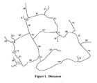
- the first step is to compute the minimum cost tree from the source node to all other nodes. This is typically performed using a variant of Dijkstra's Algorithm or the A* Algorithm, often enhanced by clever use of trunk roads, precomputation and graph restrictions to speed up the computation or reduce the storage requirements. For our example, we show the result of this as Figure 2 .
- each road segment we have annotated the distance from the source to that end using the shortest path. From each end of each road segment, there is exactly one outgoing arrowhead that shows the way back towards the source using the shortest path. We call this a back pointer. Note that for a source tree it will be in the opposite direction to the direction of travel. These are computed and stored as a necessary part of the Dijkstra's or A* Algorithm.
- the shortest path from the source to the node marked as the destination can be traced backwards by following the arrowheads back through the nodes whose distances are 282, 245, 207, 197, 130, 85, 25, 14 and finally, 0.
- This is the shortest path route from source to destination, and would be traced in just this way by Dijkstra's or the A* Algorithms.
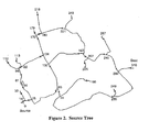
- the second step is to compute the minimum cost tree to the destination node from all other nodes. This is just a variant of the previous algorithm and the output is shown as Figure 3 . This time, the annotations give the distance to the destination node along the shortest path, and the arrowheads, again exactly one from the end of each road, show the way forward to the destination using the shortest path.
- the shortest path to the destination from the node at the top left with distance 234 is found by following the arrowheads through the adjacent nodes whose distances are 225, 215, 174, 113, 103, 65, 28, and 0.
- This tree also encodes the globally shortest path, which is found by following the arrowheads from the source node through to the destination node, and will always be identical to the one found from Figure 2 .
- first tree ( Figure 2 ) encodes the shortest path routes from a single node to many others
- second tree ( Figure 3 ) encodes the shortest path to a single node from many others.
- the next step in our method is, for each node, to add together the minimum costs from each tree. We call this the cost-sum.
- the result of this is shown in Figure 4 .
- the number 471 at the top was arrived at by adding the corresponding numbers 218 and 253 from the tops of Figure 2 and Figure 3 .
- each node we begin by giving each node a single bit that indicates that we have visited it, initially 0 for not-visited. We then scan over every node in turn, the order does not matter. If it is marked as visited (1), we move on to the next node in the scan. If the node is marked as not-visited (0), then we change that to 1 to indicate that we have visited it. For each such newly-marked node, call it node Q, we begin a list of adjacent nodes in the chain by adding just a reference to that node Q.
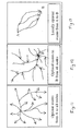
- a plateau is formed when the source and destination trees traverse a chain of road segments in the same directions. This indicates that the chain is both useful for gutting away from the source, and for getting towards the destination. This is a powerful indication that the chain may be useful for getting from the source to the destination.
- Such chains tend to use the best roads in their vicinity, and are aligned to help in getting from source to destination. On a real road network with millions of nodes, there are many thousands of such chains, many of them very short.
- a useful plateau for getting from source to destination will tend to be longer than those that are less useful, as it indicates a long stretch of route that is fast and well-aligned compared to others in its vicinity. Thus we are looking for a larger value of L.
- a useful plateau for getting from source to destination will tend to be part of a route that is not too long, as we are not interested in long plateaux if they are found at a great distance from both source and destination. Thus we are looking for a smaller value of SP + L + PD.
- the optimum route has a goodness G of 99
- routes where the route outside the plateau is about the same as the optimum route have a value of G around 1 (there are usually thousands of these, they are all the minor variations on the globally optimum route)
- worse routes have a value less than 1, which can go rapidly negative.
- G For presentation to the user, we can use the values of G as a threshold, and a value of G>50 gives good results. If they wish to see more routes, we can always keep more, down to some lower threshold, say G>10. Typically, this will be accomplished by the user asking for more alternatives, or altering the threshold value for G. This should not be necessary for the average user.
- the function that is used to find the minimum cost route can be much more complex that simply the distance travelled. In most situations, it is in fact dominated by the time taken, but may also be influenced, for example, by type of road, familiarity to the driver, financial costs, safety record in ways that are already known. We would typically use the best available time-independent cost function in the computation of the plateaux. It is simply a matter of labelling the roads with the appropriate cost instead of the distance, and the rest of the algorithm including the thresholding remains the same.
- Time dependent information could be used in the computation of the plateaux, but care would have to be taken that only one cost is associated with each road segment. Otherwise the source and destination trees might have different costs for the same segment, which would prevent us from identifying the chains using the Combined Cost (CC) values.
- CC Combined Cost
- An alternative method for handling time-dependent information is to compute the good alternative routes using the time-independent parts of the cost, and then compute the time-dependent factors for presentation to the user.
- Time dependent factors include the extra time taken due to congestion, variable toll costs and time-varying road charges.
- a user can see how the good geographical routes have been affected by the time-varying factors, and decide for themselves if a journey at another time might be more appropriate, or which route they would still like to select. For example, a driver's usual route may have become five minutes slower than the optimum due to congestion, but if they were given the choice, they may well wish to choose their usual route anyway. On another day, they might make the choice another way.
- the computer will never know enough to make this decision correctly under all circumstances, and so the driver should be informed about the realistic choices with the computer having done the hard work of estimating the distances, times, costs etc. of each choice.
- the table shows that with a threshold of G > 50, we would only recommend the routes generated from the plateaux with Combined Costs (CC) of 310, 332 and 335. Note that these happen to be the lowest values of the combined costs in the table, but that need not always be the case. Also note that all these routes have a cost that is within 10% of the globally optimum route, so other factors known only to the driver may easily outweigh the little extra distances involved, and they will be glad to have seen them all.
- CC Combined Costs
- Figures 7 to 10 are maps drawn to the same scale and extent.
- the example chosen is routes from Cambridge, UK to Manchester, UK.
- the first step is to compute the tree containing the best (minimum-cost) routes from Cambridge to all other points. This is shown in Figure 7 .
- the tree has been simplified for printing, showing only its major branches, as the leaves of the full tree would fill the land almost completely at this scale.
- Methods for computing such trees are well-known in the art, and include the Dijkstra and A* Algorithms.
- the second step is to compute the tree containing the best (minimum-cost) routes to Manchester from all other points. This is shown in Figure 8 .
- the third step is to find roads that are traversed in the same direction in both trees, that is, away from Cambridge in Figure 7 , and towards Manchester in Figure 8 . Such roads are not simply the overlap of the two trees, as the direction of traversal is important. The resulting roads are shown in Figure 9 .
- the fourth step begins by selecting the chains of roads from Figure 9 that are the longest, and generating complete routes from each by linking their endpoints back to Cambridge using the source tree of Figure 7 , and back to Manchester using the destination tree of Figure 8 .
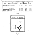
- the routes are then ranked according to their goodness (the cost of the overlapping chain minus the cost of the entire route), and in this case, we have chosen to display the top five, numbered from 0 to 4 in order of goodness.
- the final step in this embodiment is to display relevant information to the user, such as that shown in Table 1.
- Table 1. Plateau ID Description Duration Distance 0 A14,A1,A57,M1,A628 2hrs 40min 256km 1 A14,M6,A556,M56,A5103 2hrs 41min 284km 2 A14,A1,A617,A623,A6 2hrs 55min 249km 3 A14,M1,A50,A500,M6 2hrs 50min 290km 4 A14,A1(M),A1,M62,A56 2hrs 53min 297km
- RTa Routeing Tree from A
- each node or link contains a pointer to the previous one along the optimum route.
- Figure 11 shows a simple example to illustrate such a tree.
- the node or link can also contain the cost of the optimum route to that point.
- This tree has a tendency to use roads that are locally optimal and that are aligned well for getting away from A. By locally optimal, we mean that there are no minor diversions off those routes that can lower the overall cost.
- the routes generated from these chains are locally optimal, they are not globally optimal. There is, in general, only one globally optimal route, which is the one found by single routers such as Dijkstra's algorithm. The next most optimal route will usually be a minor variation upon the first, with only a tiny increase in cost. For example, on a three hour road journey that begins and ends in cities, there will be potentially hundreds of small deviations through side roads that add mere minutes to the computed journey time. All of their permutations will generate millions of routes with journey times up to, say three hours and ten minutes. Only after that might we see the first journey that used a very different route between the cities, and takes an extra 12 minutes.
- Dijkstra's algorithm In some implementations of known single routers (shortest single path from A to B), it may be desirable to use a variation of Dijkstra's algorithm. These use special heuristics to explore the nodes or edges in a better order, or to terminate earlier, or to explore major roads only, or to explore outwards from source and destination simultaneously. They do this in order to run faster or to use less memory. It should be understood that our method of combining RTs to find plateaux is independent of how the RTs were computed, so if these variations are appropriate, then our method can be applied to them to yield diverse alternative routes while taking advantage of their better running time or memory use characteristics.
- the cost function that is used to compute the best diverse alternative routes can incorporate any of the known factors. It may be sensitive to both time and duration, can incorporate real-time or historical traffic information, can take into account user preferences, and can use financial information such as road pricing.
- Another problem with known route planners is that the user may wonder why some other route was not recommended. By showing them the alternative routes along with their characteristics, it is easy for the user to see how their alternative route compares to the best, and to make an appropriate choice. For example, the usual route may be subject to unusually high congestion, our an alternative route may have become preferable because of the construction of a bypass.
- a route planning tool we could highlight the different routes using different colours, and present a text box with relevant details about each route such as time, cost etc.
- An example of such a text box for the Cambridge to Manchester routes described hereinbefore is shown in Figure 14 . Selecting a route on the map could highlight the relevant line in the text box, and selecting a line in the text box could highlight the relevant route on the map. In this way, a user could make their choice of route with as much information as we can give.
- the Source Link which is found at the beginning of every Choice Route. If the next link on every Choice Route is the same, then we move on to that. If the next link is different on different routes, then we have reached a choice point, and follow each route separately as if we had just begun again at the source link. We finish when each route arrives at the Destination Link.
- junctions For road networks for example, we may represent junctions as nodes in the graph, and road links between them as edges in the graph.
- costs of traversing the roads for example the distance and average time taken to traverse a length of road between junctions
- costs to the edges For represent the costs of passing through a junction, for example the time taken to proceed straight on, or to turn left or right, we can assign costs to a node that are dependent on the edge used to reach the node, and the edge used to leave that node.
- each edge is uni-directional, so a stretch of two-way road is represented by two edges, one for each direction of travel, and these strictly form the nodes of the graph. This allows us to encode different delays for each direction of travel, which may be important at times of congestion.
- each edge a Link.
- each Link has a set of pointers to the next Links that can be reached from it in the graph. These are called the NextLinks. These NextLink pointers are strictly the edges of the graph. Associated with each such pointer are the costs (in time, distance, financial cost etc.) of moving from the original Link to the next one. Our implementation chooses to use the time taken to move from the midpoint of one Link edge to the midpoint of another (NextLinkTime), but others may choose to use the beginning of the Links, or their ends, it makes no difference to the outcome.
- NextLinkTime the time taken to move from the midpoint of one Link edge to the midpoint of another
- each Link For computing optimum routes to a particular destination Link rather than form a source Link, we give each Link a set of PrevLinks, which encode the costs of entering that Link from all possible predecessor Links, that is, the segments of road from which it can be entered. There is some redundancy here, as every Prevlink has a corresponding NextLink, so we use more memory than some representations, but we have a lower running time.
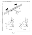
- Figure 16 shows a picture of a road junction, where the side road is one-way towards the junction.
- the section of road marked A is represented by two links, marked 1 and 3, as it is a two-way road.
- road segment B is represented by two links, 2 and 4.
- Road segment C is only represented by one link, 5, as it is a one-way road towards the junction.
- NextLink (arrow) emanating from link 1, which points to link 2.
- NextLink emanating from link 4 which points to link 3.
- Vehicles travelling on road segment C towards the junction can turn onto either segment A or segment B travelling away from the junction, so the corresponding link 5 has two NextLinks emanating from it, pointing to links 2 and 3.
- An important factor here is that the NextLinks can be enumerated from the link from which they emanate, not from the links that they point towards.
- the PrevLinks are the inverse of the NextLinks, and are again enumerated from the link that they emanate from. They indicate the links from which vehicles may enter this link. For example, vehicles may enter road segment A at this junction from either road segment B or C, so link 3 has PrevLinks that point to link 4 and to link 5.
- This link data is stored as a set of files, one for each type of information, that can easily be mapped into memory for efficient access.
- Each link is given a simple integer ID, length 32 bits, from 0 upwards, which is then used as an offset into various files.
- linkID 435 as an example.
- the length of link 435 will be found at the 435 th 16-bit word of file LinkDistance, encoded as the length in metres in 16 bits.
- the links that can be reached from link 435, its NextLinks have 32-bit linkIDs in a file called NextLinks.
- the 435 th 32-bit word in file NextLinkIndex gives the offset in the file NextLinks where the linkIDs of the next links will be found, contiguously.
- nLinks nNextLinks.
- INT32 Contains the number of links (nLinks) and the number of next-links (nNextLinks), and prev-links (nPrevLinks) and maybe other top level information about how the files were generated etc. So far, all three fields are INT32.
- a link is defined by its link index, an integer between 0 and nLinks-1, which indexes all of the arrays contained in files whose length is a multiple of [nLinks].
- PrevLink Contains the next links (by index) that can be accessed from one link
- the routeing algorithm that we use (a version of Dijkstra's algorithm) to construct the min-cost routes from a given link to all other links (the Source Routeing Tree) is as follows:
- TTBackIndex1 contains the back pointers for tree 1.
- n is 0 and 1.
- file lengths are given in square brackets after the file name:
- TTBackIndex0 To find the optimum route from the source link linkA to the destination link linkB, we need only use the TTBackIndex0 file: For example, suppose that linkB had ID 678,123. The link that led us to linkB along the optimum route is found at offset 678,123 in the file TTBackIndex0. Suppose this link had ID 1,456,789. The link that led us to this one along the optimum route is found at offset 1,456,789 in the file TTBackIndex0. We keep repeating this until the link ID extracted from the file matches the linkID of the source link linkA. Then we have extracted all of the link IDs of the optimum (shortest) path in reverse order. This is a common way of extracting the shortest path once Dijkstra's algorithm has terminated.
- the routeing algorithm that we use (a version of Dijkstra's algorithm) to construct the min-cost routes from all links to a given link (the Destination Routeing Tree) is as follows:
- TTBackIndex1 To find the optimum route from the source link linkA to the destination link linkB using the Destination Tree, we need only use the TTBackIndex1 file. For example, suppose that linkA had ID 238,345. The link that linkA preceded along the optimum route is found at offset 238,345 in the file TTBackIndex1. Suppose this link had ID 1,432,876. The link this one preceded along the optimum route is found at offset 1,432,876 in the file TTBackIndex1. We keep repeating this until the link ID extracted from the file matches the linkID of the destination link linkB. Then we have extracted all of the link IDs of the optimum (shortest) path in forward order. This is a common way of extracting the shortest path once Dijkstra's algorithm has terminated.
- this path will be identical to the one extracted from the Source Routeing Tree in the section above. It does not matter if Dijkstra's algorithm is run from the source node outwards or the destination node inwards, it will always find the single shortest path route from linkA to linkB. However, the Routeing trees that are a by-product of Dijkstra's algorithm are very different. The only route that they share completely in common is the global shortest-path route.
- the cost at offset ⁇ linkC> in the file TTMinCost1 is the cost of the minimum cost route from linkC to the destination linkB.
- the cost at offset ⁇ linkC> in the file TTMinCost0 is the cost of the minimum cost route from the source link linkA to linkC. If we add these two quantities together, we have found the cost of the minimum cost route from linkA via linkC to linkB.
- the chains are identified by the cost of going from linkA to linkB on mincost routes via any of the links in the chain being the same cost. For this reason, we call such a chain a plateau, as the sum of the costs is constant along the links that it is composed of.
- next two subsections give alternative methods for finding the links that are part of plateaux, which may have different advantages according to the properties of the cost function, and the memory and processor architecture on which the methods are implemented. It will also be apparent that these methods can be adapted to different graph representations, means of storing the flags, and properties of the cost functions.
- TCFlags01[nLinks] A series ofINT8's used as flags when combining RTs denoted by 0 and 1. Once this scan is complete, we have flagged all links that are part of a chain (using bit7), excluding the end two links.
- n goodness values where n is greater than the number that we could possibly want to display to the user, say 100.
- the goodness could be computed in any way, using any of the properties of routes such as length, financial cost, types of road, distance from source or destination.
- raw goodness is the negative of the cost of the route involving the plateau that is not part of the plateau, divided by the cost of the globally mincost route (GMCost).
- This raw goodness will have a value of zero for the globally minimum cost route, as there is zero cost outside the plateau.
- the goodness cut-off point 50 (or -0.85 in raw goodness), and via display or otherwise make the user aware of only these choices.
- the set of diverse alternative routes should include all those that we knew about as good routes from our own experiences, or at least minor variations on them (as the routeing database does not perfectly reflect the user's view of costs, but is roughly correct over the longer stretches).
- the set of diverse alternative routes should include each of the best single routes computed by other route planners such as (for Great Britain) Microsoft AutoRoute, ALK CoPilot, Medion Navigator, ISYS Personal Navigator.
- the trees can be saved by keeping the files in which their costs and back pointers have been computed, or if an alternative implementation has been used, then new file formats could be defined for the storage of this information. If storage is at a premium, then strictly only one of either the back pointers or the costs need to be stored, as a scan through the routeing database can be used to reconstruct the other without the need to run a full routeing algorithm again.
- a conventional router will run something similar to Dijkstra's algorithm to find the best route, where the link costs have been altered to reflect the latest time-dependent information, and where they are sensitive to the time that the links are expected to be traversed.
- the choice routes computed under the restricted cost function may no longer include the globally optimum route under the full cost criteria.
- time-dependent optimal routes are likely to involve more minor roads, along which there are no traffic sensors or reports. These roads appear to be free-flowing, where in reality they may be clogged, so the chosen routes may not be optimum after all.
- the RTs using the basic cost function do not have to be re-computed when the other cost factors are varied.
- a good desktop interface should allow the user to sort the alternative routes by time, distance, financial cost, type of road, number of turns etc. as they explore their options. This does not necessarily require any recomputations, as those factors can be computed and stored along with the alternative routes when they are first generated.
- the Choice Routes do not have to be used singly. If we have journey information in the form of Origins and Destinations of journeys, we can use the choice routes to allocate traffic to all of the links used in those routes in proportion to the goodness of the routes. When calibrated against real data by the adjustment of the parameters used in the goodness computation, the use of a Choice Routeing algorithm at the heart of such tools may give a more accurate prediction of traffic patterns than with current tools based on flow or single-route algorithms.
- Methods of this type may also be applied to the routeing of wires, conductors or cables, for example in buildings, aircraft, printed circuit boards and integrated circuits.
- finding a route for a wire there are a few differences from the case for road routes, particularly the routeing of wiring nets, and the additional variable of placement order.
- this technique does not replace the known techniques, as we may still have to rip-up and re-route some nets, but we will sort the unplaced nets by the amount of choice available, always placing those with the least choice first, which should speed up the time to find a solution, and more importantly, will improve the final result by keeping the wiring nets shorter overall, or not requiring such wide routeing channels.
- Figure 17 shows an example of a navigation apparatus in the form of a computer 10 with a program memory 11, such as a ROM, flash memory, a hard disk drive and/or an optical disk drive, installed in a vehicle such as an automobile.
- a program memory 11 such as a ROM, flash memory, a hard disk drive and/or an optical disk drive
- a vehicle such as an automobile.
- a program memory 11 such as a ROM, flash memory, a hard disk drive and/or an optical disk drive
- a vehicle such as an automobile.
- a program memory 11 such as a ROM, flash memory, a hard disk drive and/or an optical disk drive
- a vehicle such as an automobile.
- such an apparatus is not limited to use in vehicles and may be attached to or installed in other objects.
- such an apparatus may be installed in a cellular or mobile telephone, for example of the type which receives information about its geographical location and about the current time.
- the vehicle comprises vehicle electronics 12, which monitor and control many of the systems on board the vehicle.
- the computer 10 is thus able to receive information about various aspects of the current state of the vehicle.
- the vehicle is further provided with a GPS receiver 13 for determining the location of the vehicle and the current time from signals received from the GPS via an aerial 14. This information is also supplied to the vehicle electronics 12, for example so as to provide the function of a satellite navigation or "Sat Nav" system.
- the computer 10 is also provided with an output device 15 for providing a human-perceivable output.
- the output device 15 is illustrated in the form of a display, for example forming part of the Sat Nav system or of an in-vehicle entertainment system, but may alternatively or additionally comprise an audio output device such as a loudspeaker.
- the computer 10, the program memory 11 and the receiver 13 are shown as separate items in Figure 17 , they may be embodied by a single apparatus which may also include the display 15.
- a common means of making route computations faster is to restrict the search to a subset of roads that are generally faster or more useful when sufficiently far from the origin or destination of the journey.
- priority roads and the subset is arranged to also include junctions, slip roads etc. to ensure that they are fully connected.
- a set of such roads is shown in Figure 18 .
- the techniques of choice routing where the source and destination trees are combined to find chains of road links that are traversed in the same direction in each tree, will still work successfully with such restricted trees.
- Choice Routing it is not necessary to cover the slower local roads at both origin and destination in both trees.
- This method has two advantages over trying to compute a source or destination tree with slower roads used at both source and destination. Firstly, we reduce the computation overheads from two slow road type searches in each tree to just one for each tree, so choice routing becomes more efficient and closer to the costs of just running a conventional router. Secondly, the decision on when to switch from slow roads to a faster road type is much easier when moving away from the origin in the source tree, or away from the destination in the destination tree. This is because we can notice how many roads of the higher types we have encountered and use that as part of the switching criteria. This can easily be done several times for a hierarchy of faster road types.
- a conventional router would have higher overheads when moving towards the destination in the source tree, because of the occasional difficult case where slower road types must be used for the last 30 miles, but which is not known in advance. Thus, the conventional router would switch at this worst case distance all of the time. For the common cases though, where slower road types might only be necessary for the last 5 miles, switching to slower road types at 30 miles distance is very wasteful.
- time dependent information such as the average road speeds for each five minute period of each day
- the driver could now choose a route that they wished to be guided on by selecting one of the routes, by some conventional interface such as a button, touchscreen, or by voice command.
- some conventional interface such as a button, touchscreen, or by voice command.
- a conventional guidance system would recompute the optimal route from the current position to the destination and resume guidance along that. Our problem is that this new optimal route may not be the chosen choice route, so the driver would find themselves not being guided along the way that they had chosen. Once the driver was far enough along the chosen route that they were on the plateau, then we know that the optimal route to the destination is indeed the choice route itself but, until the route reaches the plateau section, there will in general be a more optimal route that does not use the plateau. This then gives us one possible solution.
- any of the conventional solutions can be used. For example, if the driver strays from the route that we are guiding them along and the newly computed optimal route to the via becomes one that moves away from the final destination for some distance (or cost), as known from the destination tree, then we can cancel the guidance to the via as if it had been reached and continue guidance from the next choice point after that via or the beginning of the plateau on the route with the highest goodness, whichever would have been reached first.
- An example of this is where we want to look for good stopping places on a journey.
- we can find all points of interest perhaps restaurants, toilet facilities, petrol stations, rest areas) that lie within some distance from it as the crow flies.
- One technique is to compute the perpendicular distance to each link on the route to find the minimum perpendicular distance, and another is to compute the straight-line distance to each junction on the route to find a lower bound on the driving distance.
- the trees can also contain the cumulative time, distance, safety or other factors, in addition to the cost function that they are minimising, and then these can be used in the thresholding. For example, we may find all those restaurants that do not add more than ten minutes to our estimated driving time. To do this without using the combined tree would involve running a routing algorithm twice for each node found by the proximity search, which would complicate the code, take an uncomfortably long time, and consume precious CPU and memory resources.
Landscapes
- Engineering & Computer Science (AREA)
- Business, Economics & Management (AREA)
- Physics & Mathematics (AREA)
- Radar, Positioning & Navigation (AREA)
- Remote Sensing (AREA)
- General Physics & Mathematics (AREA)
- Strategic Management (AREA)
- Theoretical Computer Science (AREA)
- Development Economics (AREA)
- Human Resources & Organizations (AREA)
- Economics (AREA)
- Computer Networks & Wireless Communication (AREA)
- Signal Processing (AREA)
- Game Theory and Decision Science (AREA)
- Entrepreneurship & Innovation (AREA)
- Accounting & Taxation (AREA)
- Marketing (AREA)
- General Business, Economics & Management (AREA)
- Finance (AREA)
- Automation & Control Theory (AREA)
- Operations Research (AREA)
- Quality & Reliability (AREA)
- Tourism & Hospitality (AREA)
- Mathematical Physics (AREA)
- Educational Administration (AREA)
- Educational Technology (AREA)
- Navigation (AREA)
Applications Claiming Priority (2)
| Application Number | Priority Date | Filing Date | Title |
|---|---|---|---|
| GB0621508A GB2443472A (en) | 2006-10-30 | 2006-10-30 | Method of generating routes |
| PCT/GB2007/050558 WO2008053240A1 (en) | 2006-10-30 | 2007-09-18 | Method of and apparatus for generating routes |
Publications (2)
| Publication Number | Publication Date |
|---|---|
| EP2084493A1 EP2084493A1 (en) | 2009-08-05 |
| EP2084493B1 true EP2084493B1 (en) | 2013-09-11 |
Family
ID=37546166
Family Applications (1)
| Application Number | Title | Priority Date | Filing Date |
|---|---|---|---|
| EP07804462.5A Active EP2084493B1 (en) | 2006-10-30 | 2007-09-18 | Method of and apparatus for generating routes |
Country Status (5)
| Country | Link |
|---|---|
| US (1) | US8249810B2 (enExample) |
| EP (1) | EP2084493B1 (enExample) |
| JP (1) | JP5448827B2 (enExample) |
| GB (1) | GB2443472A (enExample) |
| WO (1) | WO2008053240A1 (enExample) |
Cited By (1)
| Publication number | Priority date | Publication date | Assignee | Title |
|---|---|---|---|---|
| WO2020132764A1 (es) * | 2018-12-28 | 2020-07-02 | Universidad Técnica Federico Santa María | Un método de enrutamiento para redes ópticas dinámicas wdm con restricciones de continuidad de longitudes de onda |
Families Citing this family (136)
| Publication number | Priority date | Publication date | Assignee | Title |
|---|---|---|---|---|
| US7565155B2 (en) * | 2002-04-10 | 2009-07-21 | Networks In Motion | Method and system for dynamic estimation and predictive route generation |
| US8560223B2 (en) | 2002-08-29 | 2013-10-15 | Mapquest, Inc. | Automated route determination |
| ATE479075T1 (de) * | 2007-05-04 | 2010-09-15 | Harman Becker Automotive Sys | Verfahren und vorrichtung zur routenbestimmung |
| US7911944B2 (en) * | 2007-12-26 | 2011-03-22 | Nortel Networks Limited | Tie-breaking in shortest path determination |
| US8761022B2 (en) * | 2007-12-26 | 2014-06-24 | Rockstar Consortium Us Lp | Tie-breaking in shortest path determination |
| FR2926880B1 (fr) * | 2008-01-24 | 2010-09-10 | Mediamobile | Estimation de plus court chemin dependant du temps dans un reseau routier |
| CN102027325B (zh) * | 2008-06-25 | 2014-08-06 | 通腾科技股份有限公司 | 检测寻找停车设施的导航设备及方法 |
| JP4538537B2 (ja) * | 2008-06-27 | 2010-09-08 | 株式会社ナビタイムジャパン | 経路探索装置および経路探索方法 |
| KR101640461B1 (ko) * | 2008-06-30 | 2016-07-18 | 톰톰 인터내셔날 비.브이. | 위치를 표시하는 부호화된 데이터로부터 위치를 분석하는 방법 |
| DE102009014978A1 (de) * | 2008-10-10 | 2010-04-29 | Eads Deutschland Gmbh | Rechenzeiteffiziente Routenbestimmung entlang mehrerer vorgegebener Wegpunkte mit dazwischenliegenden gegebenen Verbindungsstrecken |
| CN102187178B (zh) * | 2008-12-22 | 2015-11-25 | 电子地图北美公司 | 用于绿色路线选择的方法、装置和地图数据库 |
| WO2010081538A2 (en) * | 2009-01-14 | 2010-07-22 | Tomtom International B.V. | Navigation device & method |
| EP2504663A1 (en) | 2009-11-24 | 2012-10-03 | Telogis, Inc. | Vehicle route selection based on energy usage |
| CN102918358A (zh) | 2010-04-09 | 2013-02-06 | 通腾北美有限公司 | 从表示位置的数据解析位置的方法 |
| EP2375364A1 (en) * | 2010-04-12 | 2011-10-12 | Karlsruher Institut für Technologie | Method and system for time-dependent routing |
| US8583363B2 (en) * | 2010-05-26 | 2013-11-12 | Microsoft Corporation | Determining alternative routes |
| CN107197492A (zh) * | 2010-10-01 | 2017-09-22 | 交互数字专利控股公司 | 用于协调不连续接收drx的方法 |
| CN103429989B (zh) | 2010-12-30 | 2017-10-20 | 泰为信息科技公司 | 具有受限资源路线规划最佳化器的导航系统及其操作方法 |
| US8538677B2 (en) | 2010-12-30 | 2013-09-17 | Telenav, Inc. | Navigation system with constrained resource route planning mechanism and method of operation thereof |
| EP2918973B1 (en) * | 2010-12-31 | 2023-01-18 | TomTom Navigation B.V. | Non-uniform weighting factor as route algorithm input |
| CN102176283B (zh) * | 2011-01-07 | 2013-05-08 | 重庆大学 | 一种简化交通路网模型的导航方法 |
| GB201100403D0 (en) | 2011-01-11 | 2011-02-23 | Totom Dev Germany Gmbh | An efficient location referencing method |
| JP5715840B2 (ja) * | 2011-02-04 | 2015-05-13 | 本田技研工業株式会社 | 軌道計画方法、軌道制御方法、軌道計画システム及び軌道計画・制御システム |
| US8494770B2 (en) | 2011-03-15 | 2013-07-23 | Qualcomm Incorporated | Method and system for generating savings routes with a portable computing device |
| US8818712B2 (en) * | 2011-03-28 | 2014-08-26 | Raytheon Company | Maritime path determination |
| US8566030B1 (en) * | 2011-05-03 | 2013-10-22 | University Of Southern California | Efficient K-nearest neighbor search in time-dependent spatial networks |
| US8954266B2 (en) * | 2011-06-28 | 2015-02-10 | Microsoft Technology Licensing, Llc | Providing routes through information collection and retrieval |
| US20130054141A1 (en) * | 2011-08-29 | 2013-02-28 | Princeton Satellite Systems | Weighted Path Selection for Mapping Route Selection |
| US8706413B2 (en) * | 2011-10-17 | 2014-04-22 | Qualcomm Incorporated | Determining a likelihood of a directional transition at a junction in an encoded routability graph description |
| US8731811B2 (en) * | 2011-10-20 | 2014-05-20 | Honeywell International Inc. | Methods and systems for displaying a taxi clearance |
| GB2497981B (en) * | 2011-12-23 | 2013-11-13 | Charles Linfield Davies | Generating travel time data |
| GB201200700D0 (en) * | 2012-01-17 | 2012-02-29 | Rolls Royce Plc | Vehicle energy and power management method and system |
| US20130191190A1 (en) * | 2012-01-20 | 2013-07-25 | Xerox Corporation | Method and system for motivating and optimizing usage of high occupancy vehicle/high occupancy toll lane by displaying time based cost metrics |
| EP2631594B1 (en) * | 2012-02-22 | 2015-09-09 | Harman Becker Automotive Systems GmbH | Navigation system and method for navigation |
| US20150051944A1 (en) * | 2012-05-18 | 2015-02-19 | Regents Of The University Of Minnesota | Conveyance Planning Using Dartboard Network |
| US9638537B2 (en) | 2012-06-21 | 2017-05-02 | Cellepathy Inc. | Interface selection in navigation guidance systems |
| US20150141043A1 (en) | 2013-08-23 | 2015-05-21 | Cellepathy Ltd. | Corrective navigation instructions |
| CA2877453A1 (en) | 2012-06-21 | 2013-12-27 | Cellepathy Ltd. | Device context determination |
| GB201211614D0 (en) | 2012-06-29 | 2012-08-15 | Tomtom Dev Germany Gmbh | Generating alternative routes |
| US9488491B2 (en) * | 2012-06-29 | 2016-11-08 | Denso Corporation | Navigation device and navigation program product |
| US9958272B2 (en) * | 2012-08-10 | 2018-05-01 | Telogis, Inc. | Real-time computation of vehicle service routes |
| US9552372B2 (en) | 2012-10-08 | 2017-01-24 | International Business Machines Corporation | Mapping infrastructure layout between non-corresponding datasets |
| EP2757504B1 (en) * | 2013-01-17 | 2022-06-01 | Google LLC | Route planning |
| US9749930B2 (en) * | 2013-04-11 | 2017-08-29 | Lg Electronics Inc. | Method for delivering optimum path including plurality of passage places and apparatus therefor |
| DE102013008383B4 (de) * | 2013-05-08 | 2023-01-19 | Elektrobit Automotive Gmbh | Korridorbasierte Routenberechnung |
| US9273970B2 (en) | 2013-05-14 | 2016-03-01 | Google Inc. | Systems and methods for generating a plurality of trip patterns |
| US9057612B1 (en) * | 2013-05-15 | 2015-06-16 | Google Inc. | Systems and methods for unified directions |
| US10262462B2 (en) | 2014-04-18 | 2019-04-16 | Magic Leap, Inc. | Systems and methods for augmented and virtual reality |
| GB201316013D0 (en) | 2013-09-09 | 2013-10-23 | Tomtom Dev Germany Gmbh | Methods and systems for generating alternative routes |
| JP6232913B2 (ja) | 2013-10-11 | 2017-11-22 | 富士通株式会社 | 平面グラフ生成装置、プログラム、及び方法 |
| US20150228096A1 (en) * | 2014-02-12 | 2015-08-13 | International Business Machines Corporation | Directed graph visualization |
| US10169837B2 (en) | 2014-03-17 | 2019-01-01 | Allstate Insureance Company | Mobile food order in advance systems |
| US8942727B1 (en) | 2014-04-11 | 2015-01-27 | ACR Development, Inc. | User Location Tracking |
| US9413707B2 (en) | 2014-04-11 | 2016-08-09 | ACR Development, Inc. | Automated user task management |
| US9620022B2 (en) * | 2014-06-10 | 2017-04-11 | Sikorsky Aircraft Corporation | Aircraft motion planning method |
| TW201614195A (en) * | 2014-10-02 | 2016-04-16 | Inst Information Industry | Route planning system, route planning method and traffic information update method |
| JP6492560B2 (ja) * | 2014-11-11 | 2019-04-03 | 富士通株式会社 | 情報提示方法、情報提示装置、及びプログラム |
| US20160148136A1 (en) * | 2014-11-24 | 2016-05-26 | Boyi Ni | Multiple sequential planning and allocation of time-divisible resources |
| US10144505B2 (en) * | 2015-05-18 | 2018-12-04 | The Boeing Company | Aircraft flight control using a required time of arrival index |
| EP3133550A1 (en) | 2015-08-20 | 2017-02-22 | Tata Consultancy Services Limited | Methods and systems for planning evacuation paths |
| CN105205247B (zh) * | 2015-09-16 | 2018-12-18 | 中山大学 | 一种基于树结构的仿真路网数据管理方法 |
| US10740702B2 (en) * | 2016-01-08 | 2020-08-11 | Oracle International Corporation | Method, system, and non-transitory computer-readable medium for reducing computation time in one-to-many path searching using heuristics and limited boundary adjustment |
| CN105681431A (zh) * | 2016-01-26 | 2016-06-15 | 深圳市德传技术有限公司 | 一种基于位置的空闲充电桩查找方法 |
| WO2017160276A1 (en) * | 2016-03-15 | 2017-09-21 | Ford Global Technologies Llc | Multi-day, multi-person, and multi-modal trip planning system |
| CN106094834A (zh) * | 2016-07-19 | 2016-11-09 | 芜湖哈特机器人产业技术研究院有限公司 | 基于已知环境下的移动机器人路径规划方法 |
| US10018476B2 (en) | 2016-08-17 | 2018-07-10 | Apple Inc. | Live traffic routing |
| US10060753B2 (en) | 2016-08-17 | 2018-08-28 | Apple Inc. | On-demand shortcut computation for routing |
| US20180054706A1 (en) * | 2016-08-19 | 2018-02-22 | Abl Ip Holding Llc | System for auto-commissioning of luminaires and asset tracking |
| US10410416B2 (en) * | 2016-08-25 | 2019-09-10 | Futurewei Technologies, Inc. | Collective navigation for virtual reality devices |
| US10215578B2 (en) * | 2016-08-29 | 2019-02-26 | International Business Machines Corporation | System, method and computer program product for path computing based on unpleasant data |
| US10515390B2 (en) | 2016-11-21 | 2019-12-24 | Nio Usa, Inc. | Method and system for data optimization |
| US10101170B2 (en) * | 2017-01-09 | 2018-10-16 | International Business Machines Corporation | Predicting an impact of a moving phenomenon on a travelling vehicle |
| US10989549B2 (en) * | 2017-01-27 | 2021-04-27 | International Business Machines Corporation | Route recommendation in map service |
| US10274329B2 (en) * | 2017-04-04 | 2019-04-30 | Here Global B.V. | Method and apparatus for providing a minimum overlapping alternative path |
| US10942525B2 (en) | 2017-05-09 | 2021-03-09 | Uatc, Llc | Navigational constraints for autonomous vehicles |
| US11282009B2 (en) | 2017-05-23 | 2022-03-22 | Uatc, Llc | Fleet utilization efficiency for on-demand transportation services |
| US10697789B2 (en) * | 2017-05-23 | 2020-06-30 | Uatc, Llc | Individualized risk routing for human drivers |
| US10884902B2 (en) | 2017-05-23 | 2021-01-05 | Uatc, Llc | Software version verification for autonomous vehicles |
| US11282016B2 (en) | 2017-05-23 | 2022-03-22 | Uatc, Llc | Individualized risk vehicle matching for an on-demand transportation service |
| US10489721B2 (en) | 2017-05-23 | 2019-11-26 | Uatc, Llc | Path segment risk regression system for on-demand transportation services |
| US10762447B2 (en) | 2017-05-23 | 2020-09-01 | Uatc, Llc | Vehicle selection for on-demand transportation services |
| US11080806B2 (en) | 2017-05-23 | 2021-08-03 | Uber Technologies, Inc. | Non-trip risk matching and routing for on-demand transportation services |
| US10262471B2 (en) | 2017-05-23 | 2019-04-16 | Uber Technologies, Inc. | Autonomous vehicle degradation level monitoring |
| US10789835B2 (en) | 2017-05-23 | 2020-09-29 | Uatc, Llc | Fractional risk performance evaluation for autonomous vehicles |
| US10501091B2 (en) | 2017-05-23 | 2019-12-10 | Uber Technologies, Inc. | Software version and mode switching for autonomous vehicles |
| US11288612B2 (en) | 2017-05-23 | 2022-03-29 | Uatc, Llc | Generalized risk routing for human drivers |
| WO2018217526A1 (en) * | 2017-05-23 | 2018-11-29 | Uber Technologies, Inc. | Path segment risk regression system for on-demand transportation services |
| US10837790B2 (en) | 2017-08-01 | 2020-11-17 | Nio Usa, Inc. | Productive and accident-free driving modes for a vehicle |
| US11238409B2 (en) | 2017-09-29 | 2022-02-01 | Oracle International Corporation | Techniques for extraction and valuation of proficiencies for gap detection and remediation |
| US11099021B2 (en) * | 2017-10-11 | 2021-08-24 | Toyota Motor Engineering & Manufacturing North America, Inc. | System and method for routing a vehicle |
| US20190113350A1 (en) * | 2017-10-12 | 2019-04-18 | Mitac International Corp. | Route-planning method and navigational system of converting route description into machine-readable predefined route |
| US10635109B2 (en) | 2017-10-17 | 2020-04-28 | Nio Usa, Inc. | Vehicle path-planner monitor and controller |
| US10670414B2 (en) * | 2017-10-20 | 2020-06-02 | Paypal, Inc. | Load balancing for map application route selection and output |
| US10935978B2 (en) | 2017-10-30 | 2021-03-02 | Nio Usa, Inc. | Vehicle self-localization using particle filters and visual odometry |
| US10606274B2 (en) | 2017-10-30 | 2020-03-31 | Nio Usa, Inc. | Visual place recognition based self-localization for autonomous vehicles |
| US11300416B2 (en) | 2017-11-22 | 2022-04-12 | Uber Technologies, Inc. | Dynamic route recommendation and progress monitoring for service providers |
| US10559211B2 (en) | 2017-11-27 | 2020-02-11 | Uber Technologies, Inc. | Real-time service provider progress monitoring |
| US20190186939A1 (en) * | 2017-12-20 | 2019-06-20 | Nio Usa, Inc. | Intelligent trip prediction in autonomous vehicles |
| CA3037659A1 (en) | 2018-03-23 | 2019-09-23 | Walmart Apollo, Llc | Systems and methods for transportation staffing |
| US11125574B2 (en) * | 2018-04-25 | 2021-09-21 | Here Global B.V. | Navigation optimized for unexpected traffic events |
| JP7149327B2 (ja) * | 2018-05-23 | 2022-10-06 | 株式会社 ミックウェア | 情報処理システム |
| US11287816B2 (en) | 2018-06-11 | 2022-03-29 | Uatc, Llc | Navigational constraints for autonomous vehicles |
| US20200097879A1 (en) * | 2018-09-25 | 2020-03-26 | Oracle International Corporation | Techniques for automatic opportunity evaluation and action recommendation engine |
| US11467803B2 (en) | 2019-09-13 | 2022-10-11 | Oracle International Corporation | Identifying regulator and driver signals in data systems |
| JP7714459B2 (ja) | 2018-09-27 | 2025-07-29 | オラクル・インターナショナル・コーポレイション | メトリックのデータ駆動型相関のための技術 |
| DE102018125625B4 (de) * | 2018-10-16 | 2023-01-05 | Bayerische Motoren Werke Aktiengesellschaft | Bestimmen von Alternativrouten |
| JP2020085518A (ja) * | 2018-11-19 | 2020-06-04 | トヨタ自動車株式会社 | 自動運転装置 |
| CN112611386B (zh) * | 2018-12-13 | 2022-07-01 | 杭州申昊科技股份有限公司 | 一种基于优选路线规划的变电站智能巡检方法 |
| EP3683742A1 (en) * | 2019-01-18 | 2020-07-22 | Naver Corporation | Method for computing at least one itinerary from a departure location to an arrival location |
| CN111489004B (zh) * | 2019-01-28 | 2023-05-26 | 阿里巴巴集团控股有限公司 | 一种路网预测树扩展方法、装置、电子设备及存储介质 |
| EP3745331A1 (en) | 2019-05-29 | 2020-12-02 | Naver Corporation | Methods for preprocessing a set of non-scheduled lines within a multimodal transportation network of predetermined stations and for computing at least one itinerary from a departure location to an arrival location |
| EP3745329A1 (en) | 2019-05-29 | 2020-12-02 | Naver Corporation | Methods for computing itineraries in a multimodal transportation network |
| US11482111B2 (en) | 2019-07-17 | 2022-10-25 | Uber Technologies, Inc. | Computing timing intervals for vehicles through directional route corridors |
| CN110543728B (zh) * | 2019-09-05 | 2023-03-21 | 大连理工大学 | 一种城市交通路网关键路口发现方法 |
| US11544068B2 (en) * | 2019-09-26 | 2023-01-03 | Visier Solutions, Inc. | Systems and methods for generating a pipeline of stages for a process |
| JP6937856B2 (ja) * | 2020-02-13 | 2021-09-22 | 本田技研工業株式会社 | 運転支援装置および車両 |
| US11768078B2 (en) | 2020-04-21 | 2023-09-26 | Naver Corporation | Method for computing an itinerary from a departure location to an arrival location |
| CN112199454B (zh) * | 2020-06-30 | 2022-12-13 | 武汉烽火众智数字技术有限责任公司 | 一种基于有向图的管控车辆拦截点设置方法及装置 |
| CN111784248B (zh) * | 2020-07-01 | 2023-04-07 | 深圳市检验检疫科学研究院 | 物流溯源方法 |
| CN111947676B (zh) * | 2020-08-11 | 2021-04-30 | 上海寻梦信息技术有限公司 | 快递路径规划方法、装置、电子设备以及存储介质 |
| CN114078283B (zh) * | 2020-08-12 | 2024-05-28 | 腾讯科技(深圳)有限公司 | 数据查询方法、装置、设备及计算机可读存储介质 |
| US12123725B2 (en) | 2020-08-21 | 2024-10-22 | Naver Corporation | Method for computing a personalized itinerary from a departure location to an arrival location |
| US12288470B2 (en) | 2020-11-24 | 2025-04-29 | Boom Technology, Inc. | Real time sonic boom warning system |
| CN112721948A (zh) * | 2021-01-11 | 2021-04-30 | 成都语动未来科技有限公司 | 基于预测和搜索框架的自动驾驶汽车变道调度的实现方法 |
| US11287274B1 (en) | 2021-07-20 | 2022-03-29 | iMercatus Holdings LLC | Systems and methods to improve memory management for route optimization algorithms |
| CN113715845A (zh) * | 2021-09-07 | 2021-11-30 | 北京百度网讯科技有限公司 | 一种自动驾驶方法、装置及电子设备 |
| US12158349B2 (en) | 2021-09-23 | 2024-12-03 | At&T Intellectual Property I, L.P. | Vehicular traffic flow optimization |
| WO2023081293A1 (en) * | 2021-11-03 | 2023-05-11 | Boom Technology, Inc. | Smart routing for aircraft flight planning and associated systems and methods |
| US12299608B2 (en) | 2022-04-29 | 2025-05-13 | Uber Technologies, Inc. | Generation of navigational route networks |
| JP7647709B2 (ja) * | 2022-08-09 | 2025-03-18 | トヨタ自動車株式会社 | 観光プラン提供システム及び観光プラン提供方法 |
| CN115700641A (zh) * | 2022-11-04 | 2023-02-07 | 地平线(上海)人工智能技术有限公司 | 最短路径的确定方法、装置、电子设备和存储介质 |
| CN116182888A (zh) * | 2023-02-23 | 2023-05-30 | 智道网联科技(北京)有限公司 | 多导航路线的生成方法、装置、电子设备以及存储介质 |
| CN116147652A (zh) * | 2023-02-23 | 2023-05-23 | 智道网联科技(北京)有限公司 | 导航路线计算方法、系统、设备及存储介质 |
| CN116703364B (zh) * | 2023-08-02 | 2024-01-16 | 杭州宇谷科技股份有限公司 | 基于最优化算法的运维工单生成方法和系统 |
| US20250078181A1 (en) * | 2023-09-01 | 2025-03-06 | Th2Connect, Llc | System and method for generating and updating an interactive travel itinerary |
| CN119578723A (zh) * | 2025-02-08 | 2025-03-07 | 交通运输部科学研究院 | 农村公路连通路径计算方法、装置及电子设备 |
Family Cites Families (16)
| Publication number | Priority date | Publication date | Assignee | Title |
|---|---|---|---|---|
| JP3116376B2 (ja) | 1991-06-05 | 2000-12-11 | 俊雄 築城 | ナビゲーション装置およびナビゲーション方法 |
| US5938720A (en) * | 1995-02-09 | 1999-08-17 | Visteon Technologies, Llc | Route generation in a vehicle navigation system |
| US6192314B1 (en) | 1998-03-25 | 2001-02-20 | Navigation Technologies Corp. | Method and system for route calculation in a navigation application |
| US6377551B1 (en) * | 1998-08-17 | 2002-04-23 | Nortel Networks Limited | QoS based route determination method for communications networks |
| US6401234B1 (en) | 1999-12-17 | 2002-06-04 | International Business Machines Corporation | Method and system for re-routing interconnects within an integrated circuit design having blockages and bays |
| US7020781B1 (en) * | 2000-05-03 | 2006-03-28 | Hewlett-Packard Development Company, L.P. | Digital content distribution systems |
| JP2003233768A (ja) * | 2002-02-12 | 2003-08-22 | Univ Tokyo | 複数経路探索のためのデュアルダイキストラ法 |
| US7546338B2 (en) * | 2002-02-25 | 2009-06-09 | Ascentive Llc | Method and system for screening remote site connections and filtering data based on a community trust assessment |
| JP4400104B2 (ja) * | 2003-06-18 | 2010-01-20 | 株式会社エクォス・リサーチ | 最短時間経路探索方法 |
| JP3810398B2 (ja) * | 2003-09-12 | 2006-08-16 | 松下電器産業株式会社 | 経路選出方法およびシステム |
| JP4829223B2 (ja) * | 2004-05-25 | 2011-12-07 | グーグル インコーポレイテッド | 電子メッセージソース評判情報システム |
| US8266676B2 (en) * | 2004-11-29 | 2012-09-11 | Harris Corporation | Method to verify the integrity of components on a trusted platform using integrity database services |
| US20060230039A1 (en) * | 2005-01-25 | 2006-10-12 | Markmonitor, Inc. | Online identity tracking |
| WO2006094271A2 (en) * | 2005-03-02 | 2006-09-08 | Markmonitor, Inc. | Distribution of trust data |
| US7562304B2 (en) * | 2005-05-03 | 2009-07-14 | Mcafee, Inc. | Indicating website reputations during website manipulation of user information |
| US8725811B2 (en) * | 2005-12-29 | 2014-05-13 | Microsoft Corporation | Message organization and spam filtering based on user interaction |
-
2006
- 2006-10-30 GB GB0621508A patent/GB2443472A/en not_active Withdrawn
-
2007
- 2007-09-18 EP EP07804462.5A patent/EP2084493B1/en active Active
- 2007-09-18 US US12/445,238 patent/US8249810B2/en not_active Expired - Fee Related
- 2007-09-18 JP JP2009535133A patent/JP5448827B2/ja not_active Expired - Fee Related
- 2007-09-18 WO PCT/GB2007/050558 patent/WO2008053240A1/en not_active Ceased
Cited By (2)
| Publication number | Priority date | Publication date | Assignee | Title |
|---|---|---|---|---|
| WO2020132764A1 (es) * | 2018-12-28 | 2020-07-02 | Universidad Técnica Federico Santa María | Un método de enrutamiento para redes ópticas dinámicas wdm con restricciones de continuidad de longitudes de onda |
| US11750955B2 (en) | 2018-12-28 | 2023-09-05 | Universidad Técnica Federico Santa Maria | Routing method for dynamic WDM optical networks with wavelength continuity constraints |
Also Published As
| Publication number | Publication date |
|---|---|
| GB0621508D0 (en) | 2006-12-06 |
| EP2084493A1 (en) | 2009-08-05 |
| US20100036606A1 (en) | 2010-02-11 |
| GB2443472A (en) | 2008-05-07 |
| JP2010508531A (ja) | 2010-03-18 |
| JP5448827B2 (ja) | 2014-03-19 |
| US8249810B2 (en) | 2012-08-21 |
| WO2008053240A1 (en) | 2008-05-08 |
Similar Documents
| Publication | Publication Date | Title |
|---|---|---|
| EP2084493B1 (en) | Method of and apparatus for generating routes | |
| JP2010508531A5 (enExample) | ||
| US8165800B2 (en) | Apparatus for and method of providing data to an external application | |
| CN105339761B (zh) | 用于提供行进信息的方法和设备 | |
| CN101936744B (zh) | 路径引导服务器装置、导航装置、路径引导系统及方法 | |
| US7848880B2 (en) | Traffic information adaptive to a user's travel | |
| US9291463B2 (en) | Method of verifying or deriving attribute information of a digital transport network database using interpolation and probe traces | |
| US20110137551A1 (en) | System and method for generating alternative routes | |
| US20190114909A1 (en) | Method and Apparatus for Identifying Congestion Bottlenecks | |
| US20100145608A1 (en) | Navigation based on popular user-defined paths | |
| JP4603950B2 (ja) | ナビゲーションシステム、poi探索方法、情報配信サーバおよび携帯端末 | |
| WO2008005187A2 (en) | Inferring road speeds for context-sensitive routing | |
| JP2005091303A (ja) | 経路提供装置及びプログラム | |
| JP5007152B2 (ja) | ナビゲーションシステム、経路探索サーバおよび経路探索方法ならびに端末装置 | |
| JP2009210532A (ja) | 地図表示システム、経路探索サーバおよび経路探索方法ならびに端末装置 | |
| Gavalas et al. | An efficient heuristic for the vacation planning problem | |
| CN104697543B (zh) | 一种融合个性偏好因子的路径探索方法 | |
| TW202217242A (zh) | 用於供地理區域中的車輛判定導航輪廓之方法及裝置 | |
| KR101350224B1 (ko) | 차량 경로 탐색 방법 및 장치 | |
| Kaparias et al. | ICNavS: a tool for reliable dynamic route guidance | |
| Gentile et al. | Time-dependent shortest hyperpaths for dynamic routing on transit networks | |
| EP1787087A1 (en) | Apparatus for and method of providing data to an external application | |
| Vedernikov | Optimal route planning for hitchhiking. | |
| Xu | Scalable ride-sharing through geometric algorithms and multi-hop matching | |
| Nuzzolo et al. | Time-dependent Shortest Hyperpaths for Dynamic Routing on Transit Networks |
Legal Events
| Date | Code | Title | Description |
|---|---|---|---|
| PUAI | Public reference made under article 153(3) epc to a published international application that has entered the european phase |
Free format text: ORIGINAL CODE: 0009012 |
|
| 17P | Request for examination filed |
Effective date: 20090511 |
|
| AK | Designated contracting states |
Kind code of ref document: A1 Designated state(s): AT BE BG CH CY CZ DE DK EE ES FI FR GB GR HU IE IS IT LI LT LU LV MC MT NL PL PT RO SE SI SK TR |
|
| DAX | Request for extension of the european patent (deleted) | ||
| 17Q | First examination report despatched |
Effective date: 20120529 |
|
| GRAP | Despatch of communication of intention to grant a patent |
Free format text: ORIGINAL CODE: EPIDOSNIGR1 |
|
| RIC1 | Information provided on ipc code assigned before grant |
Ipc: G06Q 30/02 20120101ALI20130522BHEP Ipc: G06Q 10/04 20120101ALI20130522BHEP Ipc: G09B 29/10 20060101ALI20130522BHEP Ipc: G01C 21/34 20060101AFI20130522BHEP |
|
| INTG | Intention to grant announced |
Effective date: 20130607 |
|
| GRAS | Grant fee paid |
Free format text: ORIGINAL CODE: EPIDOSNIGR3 |
|
| GRAA | (expected) grant |
Free format text: ORIGINAL CODE: 0009210 |
|
| AK | Designated contracting states |
Kind code of ref document: B1 Designated state(s): AT BE BG CH CY CZ DE DK EE ES FI FR GB GR HU IE IS IT LI LT LU LV MC MT NL PL PT RO SE SI SK TR |
|
| REG | Reference to a national code |
Ref country code: GB Ref legal event code: FG4D |
|
| REG | Reference to a national code |
Ref country code: CH Ref legal event code: EP |
|
| REG | Reference to a national code |
Ref country code: AT Ref legal event code: REF Ref document number: 631893 Country of ref document: AT Kind code of ref document: T Effective date: 20130915 |
|
| REG | Reference to a national code |
Ref country code: IE Ref legal event code: FG4D |
|
| REG | Reference to a national code |
Ref country code: DE Ref legal event code: R096 Ref document number: 602007032836 Country of ref document: DE Effective date: 20131107 |
|
| PG25 | Lapsed in a contracting state [announced via postgrant information from national office to epo] |
Ref country code: LT Free format text: LAPSE BECAUSE OF FAILURE TO SUBMIT A TRANSLATION OF THE DESCRIPTION OR TO PAY THE FEE WITHIN THE PRESCRIBED TIME-LIMIT Effective date: 20130911 Ref country code: SE Free format text: LAPSE BECAUSE OF FAILURE TO SUBMIT A TRANSLATION OF THE DESCRIPTION OR TO PAY THE FEE WITHIN THE PRESCRIBED TIME-LIMIT Effective date: 20130911 Ref country code: CY Free format text: LAPSE BECAUSE OF FAILURE TO SUBMIT A TRANSLATION OF THE DESCRIPTION OR TO PAY THE FEE WITHIN THE PRESCRIBED TIME-LIMIT Effective date: 20130731 |
|
| REG | Reference to a national code |
Ref country code: NL Ref legal event code: VDEP Effective date: 20130911 |
|
| REG | Reference to a national code |
Ref country code: AT Ref legal event code: MK05 Ref document number: 631893 Country of ref document: AT Kind code of ref document: T Effective date: 20130911 |
|
| REG | Reference to a national code |
Ref country code: LT Ref legal event code: MG4D |
|
| PG25 | Lapsed in a contracting state [announced via postgrant information from national office to epo] |
Ref country code: GR Free format text: LAPSE BECAUSE OF FAILURE TO SUBMIT A TRANSLATION OF THE DESCRIPTION OR TO PAY THE FEE WITHIN THE PRESCRIBED TIME-LIMIT Effective date: 20131212 Ref country code: FI Free format text: LAPSE BECAUSE OF FAILURE TO SUBMIT A TRANSLATION OF THE DESCRIPTION OR TO PAY THE FEE WITHIN THE PRESCRIBED TIME-LIMIT Effective date: 20130911 Ref country code: SI Free format text: LAPSE BECAUSE OF FAILURE TO SUBMIT A TRANSLATION OF THE DESCRIPTION OR TO PAY THE FEE WITHIN THE PRESCRIBED TIME-LIMIT Effective date: 20130911 Ref country code: LV Free format text: LAPSE BECAUSE OF FAILURE TO SUBMIT A TRANSLATION OF THE DESCRIPTION OR TO PAY THE FEE WITHIN THE PRESCRIBED TIME-LIMIT Effective date: 20130911 |
|
| PG25 | Lapsed in a contracting state [announced via postgrant information from national office to epo] |
Ref country code: CY Free format text: LAPSE BECAUSE OF FAILURE TO SUBMIT A TRANSLATION OF THE DESCRIPTION OR TO PAY THE FEE WITHIN THE PRESCRIBED TIME-LIMIT Effective date: 20130911 Ref country code: BE Free format text: LAPSE BECAUSE OF FAILURE TO SUBMIT A TRANSLATION OF THE DESCRIPTION OR TO PAY THE FEE WITHIN THE PRESCRIBED TIME-LIMIT Effective date: 20130911 |
|
| PG25 | Lapsed in a contracting state [announced via postgrant information from national office to epo] |
Ref country code: SK Free format text: LAPSE BECAUSE OF FAILURE TO SUBMIT A TRANSLATION OF THE DESCRIPTION OR TO PAY THE FEE WITHIN THE PRESCRIBED TIME-LIMIT Effective date: 20130911 Ref country code: IS Free format text: LAPSE BECAUSE OF FAILURE TO SUBMIT A TRANSLATION OF THE DESCRIPTION OR TO PAY THE FEE WITHIN THE PRESCRIBED TIME-LIMIT Effective date: 20140111 Ref country code: CZ Free format text: LAPSE BECAUSE OF FAILURE TO SUBMIT A TRANSLATION OF THE DESCRIPTION OR TO PAY THE FEE WITHIN THE PRESCRIBED TIME-LIMIT Effective date: 20130911 Ref country code: RO Free format text: LAPSE BECAUSE OF FAILURE TO SUBMIT A TRANSLATION OF THE DESCRIPTION OR TO PAY THE FEE WITHIN THE PRESCRIBED TIME-LIMIT Effective date: 20130911 Ref country code: EE Free format text: LAPSE BECAUSE OF FAILURE TO SUBMIT A TRANSLATION OF THE DESCRIPTION OR TO PAY THE FEE WITHIN THE PRESCRIBED TIME-LIMIT Effective date: 20130911 Ref country code: NL Free format text: LAPSE BECAUSE OF FAILURE TO SUBMIT A TRANSLATION OF THE DESCRIPTION OR TO PAY THE FEE WITHIN THE PRESCRIBED TIME-LIMIT Effective date: 20130911 |
|
| REG | Reference to a national code |
Ref country code: CH Ref legal event code: PL |
|
| PG25 | Lapsed in a contracting state [announced via postgrant information from national office to epo] |
Ref country code: ES Free format text: LAPSE BECAUSE OF FAILURE TO SUBMIT A TRANSLATION OF THE DESCRIPTION OR TO PAY THE FEE WITHIN THE PRESCRIBED TIME-LIMIT Effective date: 20130911 Ref country code: PL Free format text: LAPSE BECAUSE OF FAILURE TO SUBMIT A TRANSLATION OF THE DESCRIPTION OR TO PAY THE FEE WITHIN THE PRESCRIBED TIME-LIMIT Effective date: 20130911 Ref country code: AT Free format text: LAPSE BECAUSE OF FAILURE TO SUBMIT A TRANSLATION OF THE DESCRIPTION OR TO PAY THE FEE WITHIN THE PRESCRIBED TIME-LIMIT Effective date: 20130911 |
|
| REG | Reference to a national code |
Ref country code: DE Ref legal event code: R097 Ref document number: 602007032836 Country of ref document: DE |
|
| PG25 | Lapsed in a contracting state [announced via postgrant information from national office to epo] |
Ref country code: MC Free format text: LAPSE BECAUSE OF FAILURE TO SUBMIT A TRANSLATION OF THE DESCRIPTION OR TO PAY THE FEE WITHIN THE PRESCRIBED TIME-LIMIT Effective date: 20130911 Ref country code: PT Free format text: LAPSE BECAUSE OF FAILURE TO SUBMIT A TRANSLATION OF THE DESCRIPTION OR TO PAY THE FEE WITHIN THE PRESCRIBED TIME-LIMIT Effective date: 20140113 |
|
| REG | Reference to a national code |
Ref country code: IE Ref legal event code: MM4A |
|
| PLBE | No opposition filed within time limit |
Free format text: ORIGINAL CODE: 0009261 |
|
| STAA | Information on the status of an ep patent application or granted ep patent |
Free format text: STATUS: NO OPPOSITION FILED WITHIN TIME LIMIT |
|
| PG25 | Lapsed in a contracting state [announced via postgrant information from national office to epo] |
Ref country code: CH Free format text: LAPSE BECAUSE OF NON-PAYMENT OF DUE FEES Effective date: 20130930 Ref country code: LI Free format text: LAPSE BECAUSE OF NON-PAYMENT OF DUE FEES Effective date: 20130930 Ref country code: IE Free format text: LAPSE BECAUSE OF NON-PAYMENT OF DUE FEES Effective date: 20130918 |
|
| 26N | No opposition filed |
Effective date: 20140612 |
|
| PG25 | Lapsed in a contracting state [announced via postgrant information from national office to epo] |
Ref country code: IT Free format text: LAPSE BECAUSE OF FAILURE TO SUBMIT A TRANSLATION OF THE DESCRIPTION OR TO PAY THE FEE WITHIN THE PRESCRIBED TIME-LIMIT Effective date: 20130911 |
|
| REG | Reference to a national code |
Ref country code: DE Ref legal event code: R097 Ref document number: 602007032836 Country of ref document: DE Effective date: 20140612 |
|
| PG25 | Lapsed in a contracting state [announced via postgrant information from national office to epo] |
Ref country code: DK Free format text: LAPSE BECAUSE OF FAILURE TO SUBMIT A TRANSLATION OF THE DESCRIPTION OR TO PAY THE FEE WITHIN THE PRESCRIBED TIME-LIMIT Effective date: 20130911 |
|
| PG25 | Lapsed in a contracting state [announced via postgrant information from national office to epo] |
Ref country code: TR Free format text: LAPSE BECAUSE OF FAILURE TO SUBMIT A TRANSLATION OF THE DESCRIPTION OR TO PAY THE FEE WITHIN THE PRESCRIBED TIME-LIMIT Effective date: 20130911 Ref country code: MT Free format text: LAPSE BECAUSE OF FAILURE TO SUBMIT A TRANSLATION OF THE DESCRIPTION OR TO PAY THE FEE WITHIN THE PRESCRIBED TIME-LIMIT Effective date: 20130911 |
|
| PG25 | Lapsed in a contracting state [announced via postgrant information from national office to epo] |
Ref country code: BG Free format text: LAPSE BECAUSE OF FAILURE TO SUBMIT A TRANSLATION OF THE DESCRIPTION OR TO PAY THE FEE WITHIN THE PRESCRIBED TIME-LIMIT Effective date: 20130911 Ref country code: LU Free format text: LAPSE BECAUSE OF NON-PAYMENT OF DUE FEES Effective date: 20130918 Ref country code: HU Free format text: LAPSE BECAUSE OF FAILURE TO SUBMIT A TRANSLATION OF THE DESCRIPTION OR TO PAY THE FEE WITHIN THE PRESCRIBED TIME-LIMIT; INVALID AB INITIO Effective date: 20070918 |
|
| REG | Reference to a national code |
Ref country code: FR Ref legal event code: PLFP Year of fee payment: 10 |
|
| REG | Reference to a national code |
Ref country code: FR Ref legal event code: PLFP Year of fee payment: 11 |
|
| REG | Reference to a national code |
Ref country code: FR Ref legal event code: PLFP Year of fee payment: 12 |
|
| PGFP | Annual fee paid to national office [announced via postgrant information from national office to epo] |
Ref country code: FR Payment date: 20180813 Year of fee payment: 12 Ref country code: DE Payment date: 20180904 Year of fee payment: 12 |
|
| REG | Reference to a national code |
Ref country code: DE Ref legal event code: R119 Ref document number: 602007032836 Country of ref document: DE |
|
| PG25 | Lapsed in a contracting state [announced via postgrant information from national office to epo] |
Ref country code: DE Free format text: LAPSE BECAUSE OF NON-PAYMENT OF DUE FEES Effective date: 20200401 |
|
| PG25 | Lapsed in a contracting state [announced via postgrant information from national office to epo] |
Ref country code: FR Free format text: LAPSE BECAUSE OF NON-PAYMENT OF DUE FEES Effective date: 20190930 |
|
| PGFP | Annual fee paid to national office [announced via postgrant information from national office to epo] |
Ref country code: GB Payment date: 20240701 Year of fee payment: 18 |