EP1574239A1 - Méthode et Système pour l'utilisation de données géographiques en développement de jeux vidéos - Google Patents
Méthode et Système pour l'utilisation de données géographiques en développement de jeux vidéos Download PDFInfo
- Publication number
- EP1574239A1 EP1574239A1 EP05251378A EP05251378A EP1574239A1 EP 1574239 A1 EP1574239 A1 EP 1574239A1 EP 05251378 A EP05251378 A EP 05251378A EP 05251378 A EP05251378 A EP 05251378A EP 1574239 A1 EP1574239 A1 EP 1574239A1
- Authority
- EP
- European Patent Office
- Prior art keywords
- data
- geographic
- game
- database
- region
- Prior art date
- Legal status (The legal status is an assumption and is not a legal conclusion. Google has not performed a legal analysis and makes no representation as to the accuracy of the status listed.)
- Ceased
Links
Images


Classifications
-
- A—HUMAN NECESSITIES
- A63—SPORTS; GAMES; AMUSEMENTS
- A63F—CARD, BOARD, OR ROULETTE GAMES; INDOOR GAMES USING SMALL MOVING PLAYING BODIES; VIDEO GAMES; GAMES NOT OTHERWISE PROVIDED FOR
- A63F13/00—Video games, i.e. games using an electronically generated display having two or more dimensions
- A63F13/60—Generating or modifying game content before or while executing the game program, e.g. authoring tools specially adapted for game development or game-integrated level editor
- A63F13/65—Generating or modifying game content before or while executing the game program, e.g. authoring tools specially adapted for game development or game-integrated level editor automatically by game devices or servers from real world data, e.g. measurement in live racing competition
-
- A63F13/10—
-
- A—HUMAN NECESSITIES
- A63—SPORTS; GAMES; AMUSEMENTS
- A63F—CARD, BOARD, OR ROULETTE GAMES; INDOOR GAMES USING SMALL MOVING PLAYING BODIES; VIDEO GAMES; GAMES NOT OTHERWISE PROVIDED FOR
- A63F13/00—Video games, i.e. games using an electronically generated display having two or more dimensions
- A63F13/45—Controlling the progress of the video game
-
- A—HUMAN NECESSITIES
- A63—SPORTS; GAMES; AMUSEMENTS
- A63F—CARD, BOARD, OR ROULETTE GAMES; INDOOR GAMES USING SMALL MOVING PLAYING BODIES; VIDEO GAMES; GAMES NOT OTHERWISE PROVIDED FOR
- A63F13/00—Video games, i.e. games using an electronically generated display having two or more dimensions
- A63F13/60—Generating or modifying game content before or while executing the game program, e.g. authoring tools specially adapted for game development or game-integrated level editor
- A63F13/63—Generating or modifying game content before or while executing the game program, e.g. authoring tools specially adapted for game development or game-integrated level editor by the player, e.g. authoring using a level editor
-
- G—PHYSICS
- G01—MEASURING; TESTING
- G01C—MEASURING DISTANCES, LEVELS OR BEARINGS; SURVEYING; NAVIGATION; GYROSCOPIC INSTRUMENTS; PHOTOGRAMMETRY OR VIDEOGRAMMETRY
- G01C21/00—Navigation; Navigational instruments not provided for in groups G01C1/00 - G01C19/00
- G01C21/26—Navigation; Navigational instruments not provided for in groups G01C1/00 - G01C19/00 specially adapted for navigation in a road network
-
- A—HUMAN NECESSITIES
- A63—SPORTS; GAMES; AMUSEMENTS
- A63F—CARD, BOARD, OR ROULETTE GAMES; INDOOR GAMES USING SMALL MOVING PLAYING BODIES; VIDEO GAMES; GAMES NOT OTHERWISE PROVIDED FOR
- A63F2300/00—Features of games using an electronically generated display having two or more dimensions, e.g. on a television screen, showing representations related to the game
- A63F2300/60—Methods for processing data by generating or executing the game program
- A63F2300/6009—Methods for processing data by generating or executing the game program for importing or creating game content, e.g. authoring tools during game development, adapting content to different platforms, use of a scripting language to create content
- A63F2300/6018—Methods for processing data by generating or executing the game program for importing or creating game content, e.g. authoring tools during game development, adapting content to different platforms, use of a scripting language to create content where the game content is authored by the player, e.g. level editor or by game device at runtime, e.g. level is created from music data on CD
-
- Y—GENERAL TAGGING OF NEW TECHNOLOGICAL DEVELOPMENTS; GENERAL TAGGING OF CROSS-SECTIONAL TECHNOLOGIES SPANNING OVER SEVERAL SECTIONS OF THE IPC; TECHNICAL SUBJECTS COVERED BY FORMER USPC CROSS-REFERENCE ART COLLECTIONS [XRACs] AND DIGESTS
- Y10—TECHNICAL SUBJECTS COVERED BY FORMER USPC
- Y10S—TECHNICAL SUBJECTS COVERED BY FORMER USPC CROSS-REFERENCE ART COLLECTIONS [XRACs] AND DIGESTS
- Y10S707/00—Data processing: database and file management or data structures
- Y10S707/912—Applications of a database
- Y10S707/918—Location
- Y10S707/919—Geographic
Definitions
- the present invention relates to a system and method that facilitate development of computer games and more particularly, a system and method that facilitate development of computer games that include representations of actual real world geographic areas, such as the road networks in the geographic areas.
- Computer games have developed in sophistication and commercial importance. Improvements in computer hardware and software have enabled computer games to provide realistic graphics and sound. With these advances, computer game users have come to expect that games meet high standards for richness and attention to detail. For computer games that are intended to represent real world places, such as road race games, users expect the games to provide convincing depictions of the real world, with attention to accuracy and detail.
- Computer game developers have recognized the need to provide realistic depictions of actual real world places in computer games. This has placed a burden on computer game developers to obtain the data needed to portray geographic places with realistic detail and accuracy.
- the collection of such detailed geographic data about real world roads, places, etc. is time-consuming and expensive. Further, the collection of detailed real world data diverts the resources of computer game developers away from other important aspects of computer game creation, such as characters, story lines, and strategies. Thus, there exists a need to facilitate the collection and use of geographic data by game developers.
- Another consideration related to the development of computer games that depict real world places relates to providing a variety of different locales. Even if a computer game developer collects all the data needed to depict a particular real world locale (such as a city) with the richness and detail expected by game players, the game play scenario is limited to only that particular locale. This may limit the appeal of the computer game. Therefore, it may be advantageous for a computer game developer to provide games that depict a variety of different real world locales. However, if a computer game developer wants to provide a game with different real world locales, the developer is required to collect geographic data for each different locale, thus incurring further considerable expense.
- the present invention includes a system and method for facilitating development of computer games that depict or represent actual, real world (or imaginary) geographic areas as part of the play scenarios of the games.
- a source database contains data that represent geographic features in a region including roads in the region.
- the data in the source database includes attributes suitable for use for providing navigation-related functions.
- data from the source database are also provided for derived products such as games and the development thereof.
- An application programming interface, as well as other tools for handling geographic data, is provided for accessing and processing of the geographic data.
- the embodiments disclosed herein relate to computer games that depict real geographic locales as part of the play scenarios of the computer games.
- the play scenarios may involve a car chase through the streets of Miami, Florida, a treasure hunt through Europe, a flight simulator game over Texas, and so on.
- geographic data used in the computer games is obtained from a map data developer.
- the map data developer collects, confirms, updates, processes and distributes geographic data for other, non-game related purposes, such as the provision of geographic data for navigation-related purposes.
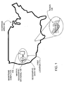
- Figure 1 shows a master or source version of a geographic database 100.
- the master version of the geographic database is owned and developed by a geographic database developer 101 (also referred to as a "map developer", a “map data developer” or the like).
- a geographic database developer 101 also referred to as a "map developer", a “map data developer” or the like.
- the master version of the geographic database 100 contains data 102 (also referred to a "geographic data” or "spatial data") that represent geographic features in a coverage area 104.
- the coverage area 104 may correspond to an entire country, such as the United States. Alternatively, the coverage area 104 may correspond to several countries, such as the United States, Canada, and Mexico, or France, Germany, and Italy, and so on. According to another alternative, the coverage area 104 of the master version of the geographic database 100 may represent only a single region within a country, such as the West Coast or the Midwest of the U.S.
- the master version of the geographic database 100 includes data that represent geographic features in the entire coverage area 104, there may be parts of the coverage area 104 that contain geographic features that are not represented by data in the geographic database, or for which the representation of geographic features is sparse.
- the master version of the geographic database 100 includes data about a road network 120 located in the coverage area 104.
- the data about the road network 120 include various kinds of information, such as the geographic coordinates of positions of the roads, street names of the roads, addresses ranges along the roads, turn restrictions at intersections of roads, and so on.
- the master version of the geographic database 100 also includes data about points of interest in the covered area 104. Points of interest may include hotels, restaurants, museums, stadiums, offices, automobile dealerships, auto repair shops, etc.
- the master version of the geographic database 100 may include data about the locations of these points of interests.
- the master version of the geographic database 100 may also include data about places, such as cities, towns, or other communities, and other geographic features, such as bodies of water, mountain ranges, etc.
- the master version of the geographic database 100 may include other kinds of information.
- the geographic database developer may employ field personnel to travel by vehicle along roads throughout the geographic region to observe features and record information about them.
- the data collected by the geographic database developer are stored in the master version of the geographic database 100.
- the geographic database developer 101 continues to collect data that represent the features in the geographic coverage area 104 on an ongoing basis.
- One reason that the geographic database developer continues to collect data is that the features in the coverage area 104 change over time. Accordingly, the geographic database developer collects data about the same features in order to update or confirm the previously collected data about the features.
- Another reason that the geographic database developer continues to collect data is to expand the coverage and/or detail of the master version of the geographic database 100. For example, at one point in time the master version of the geographic database 100 may include data that represents only a portion of the entire coverage area 104. After that point in time, the geographic database developer collects data about features in areas that were not previously represented in order to expand the coverage of the master version of the geographic database 100.
- the master version of the geographic database 100 is maintained as the copy that has the most up-to-date data relating to the coverage area 104. Accordingly, the master version of the geographic database 100 is updated, expanded, and/or otherwise modified on a regular and continuing basis. To facilitate these operations, the master version of the geographic database 100 is stored in a format that facilitates updating, maintenance, and development. For example, the data in the master version 100 may be uncompressed. Examples of suitable formats include the VSAM fonnat and the GDF format, although other kinds of formats, both proprietary and non-proprietary, may be suitable. In general, the format of the master database 100 is not suitable for use in navigation systems.
- a copy of the master version of the geographic database 100 is physically located at a first location 114.
- the master version of the geographic database 100 is stored on one or more hard drives, tapes or other media, and accessed with an appropriate computer 116. Any suitable computer may be used, such as a mainframe computer, a plurality of networked microcomputers, etc.
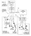
- Figure 2 shows an overview of a first embodiment of a system and method for facilitating the development of computer games that include representations of actual geographic features, such as roads, in a geographic area.
- the master version of the geographic database 100 is used to make compiled database products 110.
- the compiled database products 110 are made using a compiler 111.
- the compiler 111 is a software program run on an appropriate computer platform.
- the compiled database products 110 may include only portions of all the data in the master version of the geographic database 100.
- the compiled database products 110 may include data that relate to only one or more specific sub-areas within the coverage area 104 of the master version of the geographic database 100.
- the compiled database products 110 may include fewer than all the data attributes that describe geographic features represented in the master version of the geographic database 100.
- the compiled database products 110 are used on various kinds of computing platforms.
- the compiled database products 110 are used in computing platforms 112 used for navigation.
- the computing platforms 112 used for navigation include in-vehicle navigation systems, hand-held portable navigation systems, personal computers (including desktop and notebook computers), and other kinds of devices, such as personal digital assistant (PDA) devices, pagers, telephones, etc.
- PDA personal digital assistant
- the compiled database products 110 are also used on networked computing platforms and environments, including systems connected to the Internet.
- the compiled database products 110 that are used in computing platforms used for navigation are stored on suitable media.
- the compiled database products may be stored on CD-ROM disks, hard drives, DVD disks, flash memory, or other types of media that are available now or that become available in the future.
- the compiled database products 110 are used by various software applications.
- the compiled database products 110 may be used by software applications that provide navigation-related functions, such as route calculation, route guidance, vehicle positioning, map display, and electronic yellow pages, as well as other kinds of functions.
- the geographic database developer 101 produces one or more compiled database products 118 for use by a computer game developer 130.
- the compiled database product 118 used by the computer game developer may be the same as or similar to the compiled database products 110 used in the computing platforms 112 used for navigation.
- the compiled database product 118 used by the computer game developer 130 may be provided on a suitable media, such as one or more CD-ROM disks, DVD disks, or hard drives. Alternatively, the compiled database product 118 used by the computer game developer 130 may be provided over a network connection.
- the computer game developer 130 uses data from the compiled geographic database 118, along with other data and components (as explained below), to create one or more computer games 132.
- the computer games 132 created by the computer game developer 130 may include some or all the data from the geographic database 118.
- the computer games 132 may include data derived from or based on the data from the geographic database 118.
- the geographic data in the computer game 132 may be in a different format than the data contained in the geographic database 118.
- the computer games 132 created using the data from the geographic database 118 provide for representing geographic features in play scenarios of the computer games.
- the geographic features represented by the computer games include features located in some or all the coverage area of the geographic database 118, including some or all the road network represented by the geographic database 118.
- the computer games 132 are installed on appropriate computer platforms 134.
- the computer platforms 134 on which the computer games 132 are installed may include personal computers, game consoles, PDAs, handheld game devices, mobile phones, networked computers, and so on. Users access the computer games 132 on the computer platforms 134 to play the games.
- the computer game developer 130 uses a tool set 139.
- the tool set includes a geographic data API (application programming interface) 140 and geographic data tools 144 to access and use data contained in the compiled geographic database 118.
- the geographic database API 140 and data tools 144 are similar or identical to the interface layer and related navigation applications described in U.S. Pat. Nos. 5,974,419, 5,953,722, 5,968,109 and 6,047,280, the entire disclosures of which are incorporated by reference herein.
- the geographic data API 140 provides a library of functions that facilitate accessing the data contained in the compiled geographic database 118.
- the geographic data API 140 and data tools 144 provide various ways that the data in the geographic database 118 can be accessed. Some of these ways the geographic data API 140 and data tools 144 provide for accessing the geographic database 118 include the following:
- the spatial search function 150 supports spatial queries. Spatial queries return data records of a specified type (e.g., data that represent road segments) based on location criteria included in the query. For example, a spatial query may request all the data records that represent road segments that are within 5 km of a given latitude and longitude. Another spatial query may request all the data records that represent restaurants that are within a rectangular area having specified geographic boundaries. The spatial search function 150 returns all the data records that meet these criteria.
- a specified type e.g., data that represent road segments
- the geographic API 140 and data tools 144 provide an extraction function 154.
- the extraction function 154 supports extraction of slices of data from the geographic database 118.
- the game developer 130 may want to make a computer game that provides for representation of only a portion of the coverage area of the geographic database 118.
- the geographic database 118 may have a coverage area of Florida (i.e., includes data that represents the entire state of Florida); however, the game developer 130 wants to make a computer game in which a game player can virtually drive along only the streets of Miami.
- the game developer 130 can extract from the geographic database 118 the data that represents only the city of Miami.
- the data in the geographic database 118 may be provided with a high level of detail and/or accuracy.
- the data in the geographic database 118 may represent the locations of roads in a geographic region with a level accuracy of ⁇ 5 meters. This high level of detail is appropriate for navigation-related functions, such as vehicle positioning.
- providing a high level of detail requires a relatively large amount of data. For many computer games, a high level of detail may be unnecessary. Reducing the level of detail and/or accuracy reduces the amount of data needed to represent a geographic area. Furthermore, reducing the level of detail and/or accuracy may also facilitate processing of the data.
- the filter function 158 filters the geographic data obtained from the geographic database 118.
- the filter function 158 selectively eliminates portions of the geographic data obtained from the geographic database 118, while maintaining a given coverage area.
- the filter function 158 eliminates some of the data used to represent the shape of road segments (e.g., shape point data).
- the shape data are thinned out so that the entire road is still represented, but not necessarily with the same level of accuracy. For example, instead of representing a road with a level of accuracy of ⁇ 5 meters, the filter function 158 deletes shape point data so that the road is represented with a level of accuracy of ⁇ 25 meters. This reduction in accuracy results in a corresponding decrease in the amount of data needed to represent a geographic area.
- the filter function 158 can be operated to eliminate entire classes of roads, such as all side streets.
- the game developer can obtain data from the geographic database that suitably represents a geographic area, without having more data than is needed to represent a geographic area with the desired level of detail and/or accuracy for purposes of the computer game. This may have a favorable effect on data storage requirements for the computer game and may improve game performance, i.e., so that the game is able to realistically simulate movement through the represented area at a desired simulated speed.
- the filter function 158 may also be used by the game developer 130 to obtain geographic data at different levels of detail for games on different platforms. For example, a game developer 130 may use the filter function 158 to obtain geographic data with a relatively high level of accuracy for a console platform game, and use the filter function 158 to obtain another set of geographic data with a relatively low level of accuracy for a handheld platform game.
- the geographic API 140 and data tools 144 also include a 3D conversion function 161.
- the 3D conversion function 161 supports conversion of the data obtained the geographic database 118 so that it can be displayed as a 3D (perspective view) image.
- the 3D image may represent the geographic area from the point of view of the game player or may be from the point of view of another, e.g., a spectator.
- the view may be an overhead view.
- This 3D function may be incorporated here in the geographic API 140 and data tools 144 or may be incorporated into the other game-related components and inputs 190, described below.
- the geographic API 140 and data tools 144 also include a transformation function 160.
- the transformation function 160 converts the data obtained from the geographic database 118 into a different format.
- the different format may be one that is suitable for use by computer games.
- the data may be transformed so that it is more suitable for 3D display.
- the data may be transformed so that it can be rendered quickly, i.e., to simulate a vehicle moving at high speed.
- the data may be transformed so that it is more suitable for use with online games, e.g., Internet games.
- the geographic API 140 and data tools 144 include an integration function 164.
- the integration function 164 provides for associating data obtained from the geographic database 118 with other, new types of data. Among the new types of data that are associated with the geographic data are road models and 3D models.
- the road models and 3D models are stored in a road model database 170 and a 3D model database 174, respectively.
- the data in the road model database 170 are representations used for visual appearance and rendering of road-related things, such as road pavement, lane stripes, curbs, sidewalks, signs, lampposts, lane dividers, traffic signals, speed bumps, crosswalks, and so on. These road model representations are associated with data representation of the road network obtained from the geographic database 118. As stated above, the data in the geographic database 118 is (or is derived from) a representation of a road network used for navigation. As such, the data in the geographic database 118 may not indicate what roads, or things associated with a road, look like.
- a data representation of a road for navigation purposes may indicate the locations (e.g., geographic coordinates) of intersections, and possibly the locations of points along a road segment between intersections, the legal (and illegal) connections between roads, the names of roads, the addresses ranges along roads, the type of road surface, and so on.
- a data representation of a road for navigation purposes may not contain information that indicates the actual visual shapes, colors, dimensions, etc., of these road-related things.
- a data representation of a road for navigation purposes may not indicate the colors of a road, curbs, sidewalks, what a sign looks like, and so on.
- the road model database 170 includes these types of information.
- the integration function 164 provides for associating data in the road model database 170 with data from the geographic database 118 that represents the road network.
- the integration function 164 may associate road model data with specific locations along a road segment (as represented by data from the geographic database 118) or with lengths along a road segment.
- the integration function 164 may provide for showing curbs (using a model for what a curb looks like from the road model database 170) along all side streets (represented by data from the geographic database 118).
- the integration function 164 may provide for showing barriers along all the sides of expressways (using a model for barriers from the road model database 170) as represented by data from the geographic database 118.
- the integration function 164 may also provide for associating data models for traffic signals at intersections.
- the data representations of road-related things in the road models database are also used for providing other properties of the represented things, such as the physical and audio properties. For example, causing a simulated vehicle to move over a simulated curb causes the simulated vehicle to "bump.” Similarly, a simulated vehicle "hitting" a simulated lamppost causes a simulated crashing sound.
- the data representations from the road models database can also be used for providing feedback to the player via the user interface, if supported.
- the road model database 170 may include a variety of different data models for some types of road-related things. For example, there may be a number of different types of traffic signal configurations. These different types of traffic signal configurations are used to provide variety and to make the representation of the road network appear more realistic, i.e., so that all the traffic signal configurations do not look the same.
- the game developer uses the integration function 164 to combine data from the road model database 170 with data from the geographic database 118 to provide a realistic appearing and acting road network.
- the road model database 170 is not intended to represent the actual road-related things, such as the exact locations of or text on signs, or the exact configuration of traffic signals, etc. Neither the geographic database 118 nor the road model database may contain information that represents the actual location of signs or the exact configuration of traffic signals. However, the road model database 170 provides data for visually representing these road-related things in a manner that would be typical for the geographic area. So, for a residential neighborhood, the road model database would include models for sidewalks, cross walks, stop signs, etc., which would be associated with appropriate locations along the road network as defined by the geographic database 118.
- the integration function 164 and the road model database 170 provide for both the density (how many signs per mile or how many lampposts per block) and the style (shape, height, sign text wording) of these road related things.
- the integration function 164 associates data from the 3D model database 174 with the road network represented by the geographic database 118.
- the 3D model data in the 3D model database 174 includes representations used for visual appearance and rendering of cityscape- and landscape-related things, such as buildings fences, trees, shrubbery, lawns, fences, clouds, scenery, and so on. Like the road models, these 3D model representations are associated with locations along the road network data as represented by data from the geographic database 118.
- the data representations of cityscape and landscape-related things in the 3D models database are also used for providing the other properties (e.g., physical and audio) of the represented things. For example, causing a simulated vehicle to strike a simulated building causes the simulated vehicle to stop and make a crashing sound. As another example, a simulated vehicle can drive over a simulated shrub, but not a simulated tree.
- a data product 184 representing a geographic area and suitable for use in a computer game is produced.
- the game developer 130 uses the data product 184 in making a computer game 134.
- the game developer 130 combines the data product 184 produced using the API 140 and geographic tools 144 with other game-related components and inputs 190.
- the other game-related components and inputs 190 are data and programs that provide and/or represent characters, game logic, vehicles (both for the first person game player as well as others), and game rules.
- the other game-related components and inputs 190 also include programs for rendering and graphics.
- the other game-related components and inputs 190 may also include components (e.g., applications, programs, etc.) that make specific use of the geographic data, such as a route calculation application that determines a route that can be used as part of the play scenario of the game.
- the development of some computer games may include additional components and/or inputs whereas other computer games may require fewer. Creation and development of these game-related components and inputs are known to those of skill in the art.
- the game developer 130 combines the data product 184 produced using the API 140 and geographic tools 144 with the other game-related components and inputs 190 using a suitable linker and/or compiler 194. In the data product, the geographic data may be integrated into the code base or may exist separately.
- the computer game 134 produced by the computer game developer 130 is distributed (and/or sold or licensed) to end users using any suitable distribution channels.
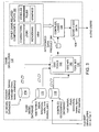
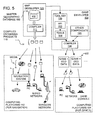
- Figure 5 shows another embodiment of a system and method for facilitating the development of computer games that include representations of actual geographic features, such as roads, in a geographic area.
- like components are indicated by the same numerals as in the previous embodiment.
- the system and method of Figure 5 are similar to the system and method of Figure 2 with the exception that the game developer 130 receives geographic data from the master geographic database 100 instead of from one of the compiled geographic databases 110, 118 produced from the master geographic database 100.
- the game developer 130 uses an interface 200.
- the interface 200 is different from the API 140 (in Figure 4) insofar as it provides for accessing geographic data in the uncompressed format in which it is stored in the master geographic database 100. This may affect the performance of the interface 200. However, this may not be a significant factor in a development environment.
- the embodiment of Figure 5 is similar to the embodiment of Figures 2-4.
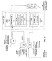
- Figure 6 shows another embodiment of a system and method for facilitating the development of computer games that include representations of actual geographic features, such as roads, in a geographic area.
- like components are indicated by the same numerals as in the previous embodiment.
- the system and method of Figure 7 are similar to the system and method of Figure 2 with the exception that the map developer 101 provides compiled geographic database products 220 which are suitable for use in computer platforms for games 134. These compiled geographic database products 220 are then distributed to end users who use the compiled geographic database products 220 in their computing platforms for games 134.
- the compiled geographic database products 220 may be distributed directly from the map developer 101 to the end users or alternatively, the compiled geographic database products 220 may be distributed through the computer game developer 130 or another third party.
- the computer game developer 130 develops computer games 234 that use the separately provided geographic database products 220.
- Figure 7 is a block diagram showing components of this embodiment. The components shown in Figure 7 are similar to those in Figure 4 with the exception that the computer game developer 130 does not include the geographic data from the map developer 101 in the game. Instead, the computer game developer 130 provides data from the road model database 170 and the 3D model database 174 along with the other game-related components and inputs 190 in a game 234.
- the game 234 is created in a way that it accesses a compiled geographic database 220 on the end user's computer platform 134.
- the end user's game platform 134 includes an appropriate API (which may be similar to the API 140 described in connection with Figure 3).
- An advantage of this embodiment is that end users may be able to obtain different compiled databases, representing different geographic areas, from the map developer 101.
- the embodiments disclosed herein describe use of geographic data in computer games.
- the embodiments disclosed herein can be adapted for using geographic data for other non-navigation-related purposes.
- non-navigation purposes are simulations and movie making.
- the embodiments disclosed herein can be adapted for using geographic data for simulation systems.
- Simulation systems that can use geographic data include systems that simulate emergency operations (such as evacuation procedures or emergency vehicle deployment and routing), driver education systems, etc.
- the embodiments disclosed herein can also be used in movie making. Many movies use computer-generated images of real (or imaginary) locations, instead of actual images.
- the embodiments disclosed herein can be adapted for creating realistic-looking geographic locations, including features such as road networks, for use in movie making.
- a relatively high visual accuracy may be required and therefore attributes that provide for relatively high visual accuracy may be needed.
- fewer attributes of some types may be required.
- the embodiments disclosed herein can be used on various different types of computer platforms, including client-server platforms and peer-to-peer platforms.
- the embodiments disclosed herein can be used with streaming or other technologies.
- the embodiments disclosed herein may also be used for games that use geographic data obtained from multiple sources, e.g., more than one source geographic database.
- the data from the multiple source geographic databases may be combined by the game developer or by another party.
- Geographic data that represents actual, real-world locales can be used in a type of computer game in which players simulate growth of an urban (or other regional) environment.
- players simulate building cities or other places (such as towns, countries, rural areas) by designing roads, utilities (e.g., electrical, sewage, water) and other infrastructure elements for a geographic area.
- utilities e.g., electrical, sewage, water
- the computer game allows a virtual city to develop based on the designs.
- the virtual cities can be detailed including individual zoning requirements (e.g., residential, commercial, industrial, etc.), crime layers (i.e., that can be changed by implementing police stations), traffic, unemployment and other realistic features.
- Geographic data that represents actual, real-world locales can be used in this type of game to provide a high level of realism thereby allowing game players to build cities based on real world city models.
- players may choose a specific city model (e.g., Paris), and attempt to improve or replicate it.
- the inclusion of real time traffic, weather, points of interest (periodically updated or real time) and other real world content would serve to increase the realism of such a virtual city. This improvement could add realism, player loyalty, recognition, and an alternative goal to this popular type of game.
- Geographic data that represents actual, real-world locales can be used in a type of computer game in which game players simulate development of a virtual person (e.g., a "sim'').
- game players simulate development of a virtual person (e.g., a "sim'').
- players build a virtual person by managing that virtual person's habits, tendencies, house, family, job and interactions with other virtual people.
- the locales in which virtual people live were non-specific.
- the locales were modeled from the view of the player's virtual house and may have included some features specific to the game manufacturer.
- Data from a source of geographic data that represents actual, real-world locales can be used in this type of game to provide a high level of realism, thereby allowing players to build virtual characters in models of real cities, with models of actual real-world-points of interest, streets, landmarks and neighborhoods.
- a player chooses a real world city. Once the city has been chosen, neighborhoods from the city become available for the player to select (e.g., Chicago's Gold Cost, Lincoln Park, Rogers Park, River North, or specific suburbs).
- the player's virtual person would be able to simulate visits to virtual attractions based on real world local attractions, e.g., go to popular restaurants and bars, work in local businesses, and reflect how life is lived in that specific area almost as if he/she were living there.
- Geographic data that represents actual, real-world locales can be used as a backbone for a "bot-fighter"-type game. This enhances the bot-fighter-type game by incorporating detailed spatial data that represents real world locales.
- a "bot-fighter"-type game can be played on mobile phones. In this game, players build “warrior robots" on their mobile phones using credits (e.g., virtual money) from battles won against other players. All firing between warriors is done via SMS messaging over the mobile phones. With mobile phone technology, a player may be given rough coordinates to his or her player-enemies or be warned when a player-enemy has entered his/her area or turf via mobile phone positioning technology.
- geographic data that represents actual, real-world locales can give this type of game greater appeal. Specific route data and location details or spotting could be provided instead of simple proximity alerts. The addition of geographic data that represents actual, real-world locales would enable this type of game to support more precise boundaries. Further, with the addition of geographic data that represents actual, real-world locales, a game player's weapons could be given more accurate range limitations, rather than rough limitations available with existing games.
- game credits e.g., virtual money
- enemy interception based on known movements or historical patterns
- data that represents the road network in the real world is used in combination with traffic feeds and models in order to simulate a real city with its existing traffic patterns.
- This computer game/application can include a vehicle fleet management feature.
- the game player is given a virtual fleet of vehicles (e.g., starting with two trucks) in an initially chosen city and an overlay of existing traffic conditions.
- the goal of the game with the fleet management feature would be to provide service to a customer base (i.e., based on real world businesses represented in the real world geographic database and some zoning data). Time of day for delivery, fleet routing, fuel expenditures, pickup points and schedules etc., would all be managed by the game player.
- Traffic flow, incidents, bottlenecks and other traffic data would be displayed.
- Wired or live devices would also have the ability to add live or updated data. Traffic would be made up from individual vehicles, following typical vehicle movement patterns (e.g., gapers, cars driving down the shoulder, etc.) or could be built from scratch.
- Geographic data that represents actual, real-world locales can be used in emergency services scenario-type games or law enforcement scenario-type games. These games include themes related to fire fighting, medical emergency services (e.g., ambulance, search and rescue), police chases, etc. Game developers who make these kinds of games can use the disclosed embodiments to provide realistic looking locales, possibly with the addition of location-based content (e.g., actual buildings, businesses etc.), traffic, weather, points of interest, etc., as part of the playing scenarios of these games.
- location-based content e.g., actual buildings, businesses etc.
- Geographic data that represents actual, real-world locales can be used in a location quiz-type of computer game.
- game players are provided with clues about a game character's secret location and attempt to determine the secret geographic location.
- Using geographic data that represents actual, real-world locales adds a measure of realism to this type of game and increases its educational value.
- One feature of this game is the ability to personalize the game to a player's locale.
- Players would be able to search for the secret location in their own city or neighborhood.
- parents could use the game to teach their children how to get around in their own neighborhoods.
- parents could set up the game to include the route that their child takes to and from school.
- the parents could obtain up-to-date digital map data that represents the new neighborhood in order to teach their children about the new neighborhood.
- Adding digital map data to the game would also provide the capability to play it anywhere the player is located. For example, a child from Chicago who is on vacation in Paris could search for the game character in Paris and thereby learn about the city.
- Another computer game/application that can use geographic data that represents actual, real-world locales is a children's atlas game/application.
- This computer game/application can be used by families on long car trips. In one embodiment, this game/application could be used to answer children's questions such as "Are we there yet?" or "Where are we?” with distances and times to destinations.
- This game includes a communications feature that allows a child to communicate with other children who have games with the same feature.
- Another version of this game/application allows a game player to create a virtual travelogue that describes and records travels in real time.
- a children's atlas game/application would be developed as a travel companion game that obtains location information from an in-vehicle navigation system or remote server.
- a specific locale e.g., a town or attraction
- a more general area e.g., a state
- the children's atlas application would display images and use voice narration to provide facts about the area.
- the children's atlas game/application would also provide well-known stories or legends about an area (e.g., Johnny Appleseed as the child is traveling through the Appalachians).
- the children's atlas includes a travel pal feature.
- This feature allows a child traveling through an area to connect online with other children who located in the area.
- children can communicate with other traveling children or with other children located in the area a child is passing through using instant messaging.
- a buddy list may be formed and used for this purpose. Children could access this service while traveling or at home. For example, children could exchange information about their travels or play games. Children passing through a particular place could instant message with children living in the area and ask questions about the area, e.g., what do the locals think about the best places to eat, what is the best radio station, etc.
- the children's atlas application includes a virtual travelogue feature.
- the virtual travelogue feature allows a child to collect, store, and send information about his or her travels as a trip is taking place.
- the child could take information provided by the atlas game/application, annotate it with personal experiences and observations, and send it to friends and relatives, or to a home website that eventually turns into a scrapbook of the entire trip (or perhaps a report on a school field trip), complete with maps, pictures and postcards from the area, voice narration, and any other data collected along the way.
- the virtual travelogue feature could also catalogue and automatically store every place the child has traveled. The child could then display or print out a map that shows all the places he or she has been and how he or she got there.
- a simulated tour application Another application that can use geographic data that represents actual, real-world locales is a simulated tour application.
- This simulated tour application uses geographic data, POI data, 3D modeling, and other data, such as weather, traffic, crime statistics, and restaurant guides, to build a realistic view of a city or other locale for virtual touring.
- the simulated tour application could be used by people considering moving to a new area, or could be hosted by realtors, or used by travelers, or simply used by individuals to learn more about different locations.
- car rally challenge-type game Another computer game that can be improved using geographic data that represents real world places is a car rally challenge-type game.
- This game can be played in single player or multi-player versions.
- teams of game players travel actual routes that are sent to them from a central server.
- the server would store a number of car rally routes and attribute scenarios (e.g., points of interest as checkpoints) for a specific area (e.g., state, city, neighborhood, etc.), and these virtual rally instructions would be sent to the participating drivers and navigators.
- An organizer's kit could also be offered that would cater to amateur car rally organizations or clubs.
- the kit would allow an individual or organization to create a customized car rally specific to a city or area.
- the rally information could be created on the rally organizer's personal computer within a program, or via download from a website. It could then be printed out and handed to the racers or downloaded to a device such as a PDA.
- the difference between the game and the kit is that the game would send out predetermined routes and rally features.
- the routes and features might change regularly but the players would not have a hand in planning or creating the rally scenarios.
- the kit would provide the basic tools and content to create a rally, thereby allowing the user to add local flavor, degrees of difficulty, or to even recreate a well-known rally course.
- Geographic data that represents real world places can be used in a computer game based on the Monopoly board game.
- a game player's positions and movements in the real world are tracked, using positioning equipment such as GPS, cell phone triangulation, etc. These movements would be used to define game routes for that player. Then, the routes would be used to identify properties (e.g., actual or fictional) along that route the game player could virtually purchase, rent, etc., as in the classic board game.
- Real world conditions such as traffic restrictions, road construction, tolls, etc., would be factored into the game play scenario.
- Geographic data that represents real world places can be used for promotional concepts (e.g., contests, sales events, and so on). Businesses, such as retailers or restaurant franchises, frequently use special promotions or contests to attract business. Adding location-based data and services to these promotions would allow businesses to better target, reach, and track potential customers, and also add an extra dimension. Promotional tie-ins to location-based data could be developed using a variety of approaches.
- Data that represents actual, real world places can be used with sports or exercise-related events or equipment.
- geographic data can be used to enhance simulators (e.g., monitors) used on or with exercise equipment.
- Geographic data that represents real places can be used with a treadmill or exercise bicycle to simulate the experience of running or biking along a route. The route would be projected on a monitor or screen in front of the person on an exercise machine such as a treadmill or exercise bicycle.
- a basic simulation would consist of a display of a basic overview map based on a route. For example, the user would ask for a route within a city and a basic map would be displayed showing the streets of the city with a mark on the map indicating the virtual position of the runner or bicyclist. The runner's progress along the route would be based on the runner's pace.
- the degree or category of simulation offered could vary depending on the level of realism desired. For example, details such as road elevation could be added to the simulation. This would allow the person exercising to experience the feeling of running or biking in the Rocky Mountains or through the plains of Kansas.
- a detailed simulation would use 3D data and give a full picture on a monitor of the buildings and landmarks along the route. This would give the runner or bicyclist a realistic feeling of running or biking along the route.
- Geographic data that represents actual, real-world locales can be advantageously used to make new versions of classic computer games like Snake and Pacman.
- game players assume the identities of characters in the game.
- a player uses positioning equipment that determines the player's actual physical position in the real world.
- the player also has equipment that provides for wireless communication with a central database.
- This player becomes a virtual player in a classic game such as PacMan or Snake.
- the games would be played in either an online competitive mode or a single player (player versus machine) mode. In either case, the player acts as a character in the game.
- the distance and speed moved by the player would be translated to movement and speed in a virtual world, where the player may accomplish goals within the game or defeat other players.
- the system would be set up in translated "virtual boards" where a game would consist of an area regulated by the speed of transportation (a "board” for a vehicle can be significantly larger than one for a pedestrian).
- Another computer game that can use embodiments of the disclosed system and method for providing geographic data is a "cannonball run" car racing game.
- This game may be played in multi-player or single player mode.
- the multi-player mode game may be played online.
- players compete against each other to race vehicles (e.g., cars, bikes, etc.) across a geographical area.
- race vehicles e.g., cars, bikes, etc.
- Data that represent actual, real-world places would be used to add realism to the game, e.g., actual legal and physical restrictions.
- Alternative features include the addition of real-time traffic and weather conditions.
- One scenario for a multi-player online version of the game would feature a community where players start out with a specific mode of transportation.
- This version of the game would provide an online culture and goal of being with the best group and driving the best vehicle.
- Players would start with a certain amount of virtual cash and a basic vehicle.
- Some races would be pre-defined events, whereas other races would be random city races with a user defined start and end points.
- the selection of routes for races would be based on real map data.
- the game would be based on winning virtual money by winning races, but winning a race could cost the player due to traffic tickets, illegal traffic maneuvers or other expenses. All fines would be based on legal restriction data and statistics of the percentage of drivers caught.
- Suggested routes would be provided in all races, and the amount of virtual cash used to buy a route would vary the quality or speed of the route.
- Game players would have the option of racing through their hometowns, or through the streets of their favorite cities or countries all over the world. These would attract a larger demographic, and interest the casual game player as well.
- Data that represents actual, real world places can be used for a computer simulation application that would allow a user to preview a trip or specific route by virtually driving it on his or her personal computer or game console.
- the simulation would be based on a representation of the geographic database that included 3D renderings of buildings, signs, topographical features, and other related attributes.
- the simulation software could be provided on media, through an online vendor, or rented to users on an as-needed basis. Users would enter a route request via their personal computers or consoles and could use gaming steering wheels, joysticks, voice commands, or keyboards to drive the routes.
- a fast forward function could be used to skip the obvious or mundane sections of the trip or to speed up the pace.
- traffic features such as vehicles coming and going on the route, could be included. These could perhaps even be based on actual traffic patterns or real-time traffic for a selected time of day.
- a feature of this simulation application would be as a form of trip planner.
- the planner would provide information about an area to which one is traveling, such as local history, area specific trivia games, and point of interest descriptions and recommendations. Users would have the option of using this information while driving the area in advance (e.g., using the simulation application, described above), printing out the planner in advance as a reference, or loading it onto a device and accessing it during an actual trip (e.g., going on a long trip and using the planner interactively to keep children amused and informed). For example, if a family was traveling on vacation from Chicago to Miami by car, the parents could research and preview the attractions, hotels, and restaurants at which the family may want to stop along the way. They could also preview the route and create their own form of trip ticket to plan the best route. The parents could then set up an itinerary that would include games, information, quizzes etc., that would occupy the children throughout the trip.
Applications Claiming Priority (2)
| Application Number | Priority Date | Filing Date | Title |
|---|---|---|---|
| US798459 | 1991-11-26 | ||
| US10/798,459 US7970749B2 (en) | 2004-03-11 | 2004-03-11 | Method and system for using geographic data in computer game development |
Publications (1)
| Publication Number | Publication Date |
|---|---|
| EP1574239A1 true EP1574239A1 (fr) | 2005-09-14 |
Family
ID=34827662
Family Applications (1)
| Application Number | Title | Priority Date | Filing Date |
|---|---|---|---|
| EP05251378A Ceased EP1574239A1 (fr) | 2004-03-11 | 2005-03-08 | Méthode et Système pour l'utilisation de données géographiques en développement de jeux vidéos |
Country Status (3)
| Country | Link |
|---|---|
| US (1) | US7970749B2 (fr) |
| EP (1) | EP1574239A1 (fr) |
| JP (1) | JP5547310B2 (fr) |
Cited By (5)
| Publication number | Priority date | Publication date | Assignee | Title |
|---|---|---|---|---|
| WO2009002879A1 (fr) * | 2007-06-26 | 2008-12-31 | Qualcomm Incorporated | Logiciel intégré de jeu dans le monde réel |
| WO2009111445A1 (fr) * | 2008-03-05 | 2009-09-11 | Motorola, Inc. | Mobilité continue pour un jeu géodépendant à travers des mondes virtuel et physique |
| US20110289008A1 (en) * | 2010-05-18 | 2011-11-24 | William Landi | Use of Satellite-Based Geographical Positioning for Demarcating Real Estate Parcels Involved in Transactions |
| CN108230803A (zh) * | 2017-12-20 | 2018-06-29 | 上海工程技术大学 | 一种基于人工智能的物联网实验装置 |
| CN111488146A (zh) * | 2019-01-25 | 2020-08-04 | 上海原品网络科技有限公司 | 一种基于安卓系统的游戏开发系统 |
Families Citing this family (75)
| Publication number | Priority date | Publication date | Assignee | Title |
|---|---|---|---|---|
| US8562439B2 (en) * | 2004-03-11 | 2013-10-22 | Navteq B.V. | Geographic area templates for computer games |
| US8547380B2 (en) * | 2004-08-05 | 2013-10-01 | Elite Avatars, Llc | Persistent, immersible and extractable avatars |
| US7675519B2 (en) * | 2004-08-05 | 2010-03-09 | Elite Avatars, Inc. | Persistent, immersible and extractable avatars |
| US7353034B2 (en) | 2005-04-04 | 2008-04-01 | X One, Inc. | Location sharing and tracking using mobile phones or other wireless devices |
| US8483616B1 (en) | 2005-11-01 | 2013-07-09 | At&T Intellectual Property Ii, L.P. | Non-interference technique for spatially aware mobile ad hoc networking |
| US8777752B2 (en) * | 2005-11-30 | 2014-07-15 | At&T Intellectual Property I, L.P. | Geogame for mobile device |
| US8355410B2 (en) * | 2007-08-17 | 2013-01-15 | At&T Intellectual Property I, L.P. | Location-based mobile gaming application and method for implementing the same using a scalable tiered geocast protocol |
| US8702506B2 (en) * | 2005-11-30 | 2014-04-22 | At&T Intellectual Property I, L.P. | Geogame for mobile device |
| US9224303B2 (en) | 2006-01-13 | 2015-12-29 | Silvertree Media, Llc | Computer based system for training workers |
| US8376857B1 (en) | 2006-04-28 | 2013-02-19 | Navteq B.V. | Multi-player online game player proximity feature |
| US7628704B1 (en) | 2006-06-15 | 2009-12-08 | Navteq North America, Llc | Geographic data collection using game play |
| US20080051989A1 (en) * | 2006-08-25 | 2008-02-28 | Microsoft Corporation | Filtering of data layered on mapping applications |
| US8135018B1 (en) | 2007-03-29 | 2012-03-13 | Qurio Holdings, Inc. | Message propagation in a distributed virtual world |
| US8116323B1 (en) | 2007-04-12 | 2012-02-14 | Qurio Holdings, Inc. | Methods for providing peer negotiation in a distributed virtual environment and related systems and computer program products |
| US8000328B1 (en) * | 2007-05-22 | 2011-08-16 | Qurio Holdings, Inc. | Filtering messages in a distributed virtual world based on virtual space properties |
| US8565781B2 (en) | 2007-07-27 | 2013-10-22 | Intertrust Technologies Corporation | Content publishing systems and methods |
| US9256654B2 (en) * | 2007-12-07 | 2016-02-09 | Microsoft Technology Licensing, Llc | Dynamic schema content server |
| US9058090B1 (en) | 2008-06-02 | 2015-06-16 | Qurio Holdings, Inc. | Collaborative information sharing in a virtual world |
| US9544922B2 (en) | 2008-09-16 | 2017-01-10 | At&T Intellectual Property I, L.P. | Quality of service scheme for collision-based wireless networks |
| US8260873B1 (en) | 2008-10-22 | 2012-09-04 | Qurio Holdings, Inc. | Method and system for grouping user devices based on dual proximity |
| US8126985B1 (en) | 2008-12-31 | 2012-02-28 | Qurio Holdings, Inc. | Prioritizing virtual object downloads in a distributed virtual environment |
| US8424075B1 (en) | 2008-12-31 | 2013-04-16 | Qurio Holdings, Inc. | Collaborative firewall for a distributed virtual environment |
| CN101853327A (zh) * | 2009-04-01 | 2010-10-06 | 鸿富锦精密工业(深圳)有限公司 | 游戏制作系统及制作方法 |
| US10675543B2 (en) * | 2009-07-28 | 2020-06-09 | Activision Publishing, Inc. | GPS related video game |
| US9118428B2 (en) | 2009-11-04 | 2015-08-25 | At&T Intellectual Property I, L.P. | Geographic advertising using a scalable wireless geocast protocol |
| CN102110364B (zh) * | 2009-12-28 | 2013-12-11 | 日电(中国)有限公司 | 基于路口和路段的交通信息处理方法和装置 |
| US20110173587A1 (en) * | 2010-01-11 | 2011-07-14 | Alien Tool Kit Software Inc. | Method and system for game development for mobile devices |
| US20110256933A1 (en) * | 2010-04-14 | 2011-10-20 | Mary Ann Place | Internet based community game |
| US8712056B2 (en) | 2010-06-03 | 2014-04-29 | At&T Intellectual Property I, L.P. | Secure mobile ad hoc network |
| US10016684B2 (en) | 2010-10-28 | 2018-07-10 | At&T Intellectual Property I, L.P. | Secure geographic based gaming |
| US10046241B1 (en) * | 2010-11-01 | 2018-08-14 | Ronald Charles Krosky | Output production |
| US20120129143A1 (en) * | 2010-11-19 | 2012-05-24 | Disney Enterprises, Inc. | System and method for generating a plot of a digital print |
| US8668592B2 (en) * | 2010-12-17 | 2014-03-11 | 2343127 Ontario Inc. | Systems and methods of changing storyline based on player location |
| US9161158B2 (en) | 2011-06-27 | 2015-10-13 | At&T Intellectual Property I, L.P. | Information acquisition using a scalable wireless geocast protocol |
| US9319842B2 (en) | 2011-06-27 | 2016-04-19 | At&T Intellectual Property I, L.P. | Mobile device configured point and shoot type weapon |
| US9495870B2 (en) | 2011-10-20 | 2016-11-15 | At&T Intellectual Property I, L.P. | Vehicular communications using a scalable ad hoc geographic routing protocol |
| US8744419B2 (en) | 2011-12-15 | 2014-06-03 | At&T Intellectual Property, I, L.P. | Media distribution via a scalable ad hoc geographic protocol |
| US20140259030A1 (en) * | 2012-01-25 | 2014-09-11 | Mitsubishi Electric Corporation | Mobile information device |
| US9501496B2 (en) * | 2012-07-30 | 2016-11-22 | Evernote Corporation | Note atlas |
| US9782668B1 (en) | 2012-07-31 | 2017-10-10 | Niantic, Inc. | Placement of virtual elements in a virtual world associated with a location-based parallel reality game |
| US9669293B1 (en) | 2012-07-31 | 2017-06-06 | Niantic, Inc. | Game data validation |
| US9621635B1 (en) | 2012-07-31 | 2017-04-11 | Niantic, Inc. | Using side channels in remote procedure calls to return information in an interactive environment |
| US9071451B2 (en) | 2012-07-31 | 2015-06-30 | At&T Intellectual Property I, L.P. | Geocast-based situation awareness |
| US9669296B1 (en) | 2012-07-31 | 2017-06-06 | Niantic, Inc. | Linking real world activities with a parallel reality game |
| US9539498B1 (en) | 2012-07-31 | 2017-01-10 | Niantic, Inc. | Mapping real world actions to a virtual world associated with a location-based game |
| US9128789B1 (en) | 2012-07-31 | 2015-09-08 | Google Inc. | Executing cross-cutting concerns for client-server remote procedure calls |
| US9604131B1 (en) | 2012-07-31 | 2017-03-28 | Niantic, Inc. | Systems and methods for verifying player proximity within a location-based game |
| US9226106B1 (en) | 2012-07-31 | 2015-12-29 | Niantic, Inc. | Systems and methods for filtering communication within a location-based game |
| US9210589B2 (en) | 2012-10-09 | 2015-12-08 | At&T Intellectual Property I, L.P. | Geocast protocol for wireless sensor network |
| US8968099B1 (en) | 2012-11-01 | 2015-03-03 | Google Inc. | System and method for transporting virtual objects in a parallel reality game |
| US9660745B2 (en) | 2012-12-12 | 2017-05-23 | At&T Intellectual Property I, L.P. | Geocast-based file transfer |
| US9992021B1 (en) | 2013-03-14 | 2018-06-05 | GoTenna, Inc. | System and method for private and point-to-point communication between computing devices |
| US10463953B1 (en) | 2013-07-22 | 2019-11-05 | Niantic, Inc. | Detecting and preventing cheating in a location-based game |
| US9545565B1 (en) | 2013-10-31 | 2017-01-17 | Niantic, Inc. | Regulating and scoring player interactions within a virtual world associated with a location-based parallel reality game |
| US20150290543A1 (en) * | 2014-04-15 | 2015-10-15 | King. Com Limited | Device, game and methods therefor |
| JP2017511510A (ja) * | 2014-04-15 | 2017-04-20 | キングドットコム リミテッドKing.Com Ltd | 装置、ゲーム、及びその方法 |
| US10458801B2 (en) | 2014-05-06 | 2019-10-29 | Uber Technologies, Inc. | Systems and methods for travel planning that calls for at least one transportation vehicle unit |
| US9552559B2 (en) | 2014-05-06 | 2017-01-24 | Elwha Llc | System and methods for verifying that one or more directives that direct transport of a second end user does not conflict with one or more obligations to transport a first end user |
| EP3183707A4 (fr) | 2014-08-21 | 2018-02-28 | Uber Technologies Inc. | Organisation d'un service de transport pour un utilisateur d'après le temps d'arrivée estimé de l'utilisateur |
| JP6513930B2 (ja) * | 2014-11-07 | 2019-05-15 | 株式会社タイトー | ゲームシステム |
| US9953540B2 (en) | 2015-06-16 | 2018-04-24 | Here Global B.V. | Air space maps |
| US10212536B2 (en) | 2015-07-10 | 2019-02-19 | Uber Technologies, Inc. | Selecting a messaging protocol for transmitting data in connection with a location-based service |
| US10685416B2 (en) | 2015-12-10 | 2020-06-16 | Uber Technologies, Inc. | Suggested pickup location for ride services |
| US10242574B2 (en) | 2016-03-21 | 2019-03-26 | Uber Technologies, Inc. | Network computer system to address service providers to contacts |
| US9813510B1 (en) | 2016-09-26 | 2017-11-07 | Uber Technologies, Inc. | Network system to compute and transmit data based on predictive information |
| JP6267383B1 (ja) * | 2017-04-12 | 2018-01-24 | 株式会社テクテック | 位置ゲームにおけるオブジェクト制御システム、プログラム及び方法 |
| US10717005B2 (en) | 2017-07-22 | 2020-07-21 | Niantic, Inc. | Validating a player's real-world location using activity within a parallel reality game |
| US10721327B2 (en) | 2017-08-11 | 2020-07-21 | Uber Technologies, Inc. | Dynamic scheduling system for planned service requests |
| US10567520B2 (en) | 2017-10-10 | 2020-02-18 | Uber Technologies, Inc. | Multi-user requests for service and optimizations thereof |
| US10731998B2 (en) | 2017-11-05 | 2020-08-04 | Uber Technologies, Inc. | Network computer system to arrange pooled transport services |
| US10788329B2 (en) | 2018-01-09 | 2020-09-29 | Uber Technologies, Inc. | Network system for multi-leg transport |
| US11403938B2 (en) | 2019-04-04 | 2022-08-02 | Geotab Inc. | Method for determining traffic metrics of a road network |
| US11669786B2 (en) | 2020-02-14 | 2023-06-06 | Uber Technologies, Inc. | On-demand transport services |
| US11654348B2 (en) * | 2020-06-16 | 2023-05-23 | Category Ten Llc | Board game relating to the Covid-19 pandemic |
| CN114386536B (zh) * | 2022-03-22 | 2022-07-01 | 腾讯科技(深圳)有限公司 | 区域确定方法、装置、计算设备以及存储介质 |
Citations (2)
| Publication number | Priority date | Publication date | Assignee | Title |
|---|---|---|---|---|
| EP1107189A2 (fr) | 1999-12-09 | 2001-06-13 | Matsushita Electric Industrial Co., Ltd. | Dispositif et procédé d'affichage de cartes |
| US20020063654A1 (en) * | 2000-11-27 | 2002-05-30 | Akihiro Aoyama | Navigation apparatus |
Family Cites Families (59)
| Publication number | Priority date | Publication date | Assignee | Title |
|---|---|---|---|---|
| US2026082A (en) * | 1935-08-31 | 1935-12-31 | Parker Brothers Inc | Board game apparatus |
| US4097051A (en) * | 1976-11-11 | 1978-06-27 | Goldberg Robert M | Board game apparatus |
| US4645459A (en) * | 1982-07-30 | 1987-02-24 | Honeywell Inc. | Computer generated synthesized imagery |
| FR2658642B1 (fr) * | 1990-02-20 | 1994-06-10 | Rousseau Codes | Procede et dispositif d'entrainement a la conduite de vehicules terrestres. |
| WO1992000654A1 (fr) * | 1990-06-25 | 1992-01-09 | Barstow David R | Procede de codage et de diffusion d'informations relatives a des evenements en direct utilisant des techniques informatiques de simulation et de concordance avec un modele |
| US5366376A (en) * | 1992-05-22 | 1994-11-22 | Atari Games Corporation | Driver training system and method with performance data feedback |
| US6268858B1 (en) * | 1992-09-08 | 2001-07-31 | L-3 Communications Corporation | Database correlatable chart generation system and method |
| US5945985A (en) * | 1992-10-27 | 1999-08-31 | Technology International, Inc. | Information system for interactive access to geographic information |
| JPH06202557A (ja) | 1992-12-28 | 1994-07-22 | Matsushita Electric Ind Co Ltd | 電子地図表示装置 |
| US5660547A (en) * | 1993-02-17 | 1997-08-26 | Atari Games Corporation | Scenario development system for vehicle simulators |
| US5616079A (en) * | 1993-06-16 | 1997-04-01 | Namco Ltd. | Three-dimensional games machine |
| US5651676A (en) * | 1993-09-02 | 1997-07-29 | Microsoft Corporation | Method of organizing and storing simulated scenery in a flight simulation system |
| US5566073A (en) * | 1994-07-11 | 1996-10-15 | Margolin; Jed | Pilot aid using a synthetic environment |
| IL112940A (en) * | 1995-03-08 | 1998-01-04 | Simtech Advanced Training & Si | Apparatus and method for simulating a terrain and objects thereabove |
| US5618043A (en) * | 1995-06-07 | 1997-04-08 | Mcglew; John J. | Game based on data base of characters of different geographic regions |
| US6023278A (en) * | 1995-10-16 | 2000-02-08 | Margolin; Jed | Digital map generator and display system |
| US6183364B1 (en) * | 1995-12-21 | 2001-02-06 | Karen I. Trovato | Simulated environment using procedural animation in a simulated city |
| US5951620A (en) * | 1996-01-26 | 1999-09-14 | Navigation Technologies Corporation | System and method for distributing information for storage media |
| JP3747449B2 (ja) * | 1996-07-25 | 2006-02-22 | 株式会社セガ | ゲームの処理方法、ゲーム装置、画像処理装置及び画像処理方法並びに記録媒体 |
| JPH10154138A (ja) * | 1996-09-27 | 1998-06-09 | Namco Ltd | コースデータ生成方法、画像合成装置及び情報記憶媒体 |
| US6047280A (en) * | 1996-10-25 | 2000-04-04 | Navigation Technologies Corporation | Interface layer for navigation system |
| US6146143A (en) * | 1997-04-10 | 2000-11-14 | Faac Incorporated | Dynamically controlled vehicle simulation system, and methods of constructing and utilizing same |
| JPH1157209A (ja) * | 1997-08-25 | 1999-03-02 | Nippon Telegr & Teleph Corp <Ntt> | 景観ラベル利用型ラリーゲームシステム |
| US6266614B1 (en) * | 1997-12-24 | 2001-07-24 | Wendell Alumbaugh | Travel guide |
| US6183634B1 (en) | 1998-04-02 | 2001-02-06 | Bateman Process Equipment Limited | Separator |
| US6362817B1 (en) * | 1998-05-18 | 2002-03-26 | In3D Corporation | System for creating and viewing 3D environments using symbolic descriptors |
| GB9820490D0 (en) * | 1998-09-22 | 1998-11-11 | Forsberg Services Limited | Computer game |
| JP2000146619A (ja) * | 1998-11-11 | 2000-05-26 | Alpine Electronics Inc | 地図情報販売装置およびナビゲーションシステム |
| US6343301B1 (en) * | 1999-02-24 | 2002-01-29 | Navigation Technologies Corp. | Method and system for collecting data for updating a geographic database |
| US6677858B1 (en) * | 1999-02-26 | 2004-01-13 | Reveo, Inc. | Internet-based method of and system for monitoring space-time coordinate information and biophysiological state information collected from an animate object along a course through the space-time continuum |
| JP2001034378A (ja) * | 1999-07-23 | 2001-02-09 | Kansai Tlo Kk | オブジェクト出力システム、オブジェクト管理装置、オブジェクト出力装置、及び記録媒体 |
| JP2001070656A (ja) * | 1999-09-02 | 2001-03-21 | Seiko Epson Corp | 仮想的な世界を表示するシステムおよび方法 |
| US6452600B1 (en) * | 1999-10-28 | 2002-09-17 | Nintendo Co., Ltd. | Graphics system interface |
| AU4148901A (en) * | 2000-02-14 | 2001-08-27 | Virtuacities, Inc. | Methods and systems for presenting a virtual representation of a real city |
| EP1136106A3 (fr) * | 2000-03-21 | 2001-12-05 | Sony Computer Entertainment Inc. | Appareil de divertissement, support d'enregistrement et méthode d'affichage d'objet |
| JP2002058872A (ja) * | 2000-08-23 | 2002-02-26 | Alpine Electronics Inc | レーシングゲームのコース作成方法 |
| US6401033B1 (en) * | 2000-09-01 | 2002-06-04 | Navigation Technologies Corp. | Navigation system with game playing feature |
| DE10048289C2 (de) | 2000-09-29 | 2002-09-12 | Audi Ag | Kraftfahrzeug mit einer elektronischen Spieleinrichtung |
| US6772142B1 (en) * | 2000-10-31 | 2004-08-03 | Cornell Research Foundation, Inc. | Method and apparatus for collecting and expressing geographically-referenced data |
| AUPR133800A0 (en) | 2000-11-09 | 2000-11-30 | Gpsports Systems Pty Ltd | Information system and method |
| JP2002159743A (ja) * | 2000-11-24 | 2002-06-04 | Jatco Transtechnology Ltd | Gps受信装置 |
| US7254249B2 (en) * | 2001-03-05 | 2007-08-07 | Digimarc Corporation | Embedding location data in video |
| JP4230132B2 (ja) | 2001-05-01 | 2009-02-25 | パナソニック株式会社 | デジタル地図の形状ベクトルの符号化方法と位置情報伝達方法とそれを実施する装置 |
| US6961055B2 (en) * | 2001-05-09 | 2005-11-01 | Free Radical Design Limited | Methods and apparatus for constructing virtual environments |
| JP3603118B2 (ja) | 2001-06-08 | 2004-12-22 | 東京大学長 | 擬似3次元空間表現システム、擬似3次元空間構築システム、ゲームシステム、及び電子地図提供システム |
| JP2003000940A (ja) | 2001-06-20 | 2003-01-07 | Enix Corp | ビデオゲーム装置、記録媒体およびプログラム |
| ES2360480T3 (es) * | 2001-06-22 | 2011-06-06 | Caliper Corporation | Sistema de gestión y simulación de datos de tráfico. |
| US20030059743A1 (en) * | 2001-08-29 | 2003-03-27 | The Boeing Company | Method and apparatus for automatically generating a terrain model for display during flight simulation |
| JP2003254763A (ja) * | 2002-02-28 | 2003-09-10 | Fujitsu Ltd | ナビゲーションシステムおよびナビゲーション方法 |
| US7038694B1 (en) * | 2002-03-11 | 2006-05-02 | Microsoft Corporation | Automatic scenery object generation |
| US6800031B2 (en) * | 2002-04-15 | 2004-10-05 | Microsoft Corporation | Method of conducting an interactive competition |
| JP2003329449A (ja) | 2002-05-14 | 2003-11-19 | Learning Space:Kk | 共用基盤道路情報の作成方法及び作成装置 |
| TW575844B (en) * | 2002-05-14 | 2004-02-11 | Via Tech Inc | Group virtual reality touring system and operation method |
| US7908324B2 (en) * | 2002-10-02 | 2011-03-15 | Disney Enterprises, Inc. | Multi-user interactive communication network environment |
| US8458028B2 (en) * | 2002-10-16 | 2013-06-04 | Barbaro Technologies | System and method for integrating business-related content into an electronic game |
| JP3902543B2 (ja) * | 2002-12-17 | 2007-04-11 | 本田技研工業株式会社 | 道路交通シミュレーション装置 |
| US7570261B1 (en) * | 2003-03-06 | 2009-08-04 | Xdyne, Inc. | Apparatus and method for creating a virtual three-dimensional environment, and method of generating revenue therefrom |
| US7707012B2 (en) * | 2003-05-21 | 2010-04-27 | Adrian Stephens | Simulated city generation |
| US20050159216A1 (en) * | 2004-01-20 | 2005-07-21 | Chaucer Chiu | Simulation game system and method thereof integrating geographical information |
-
2004
- 2004-03-11 US US10/798,459 patent/US7970749B2/en active Active
-
2005
- 2005-03-08 EP EP05251378A patent/EP1574239A1/fr not_active Ceased
-
2013
- 2013-02-04 JP JP2013019831A patent/JP5547310B2/ja not_active Expired - Fee Related
Patent Citations (2)
| Publication number | Priority date | Publication date | Assignee | Title |
|---|---|---|---|---|
| EP1107189A2 (fr) | 1999-12-09 | 2001-06-13 | Matsushita Electric Industrial Co., Ltd. | Dispositif et procédé d'affichage de cartes |
| US20020063654A1 (en) * | 2000-11-27 | 2002-05-30 | Akihiro Aoyama | Navigation apparatus |
Non-Patent Citations (2)
| Title |
|---|
| JONAH FREEDMAN: "Map Quests", WIRED.COM, February 2004 (2004-02-01), XP002335320, Retrieved from the Internet <URL:http://www.wired.com/wired/archive/12.02/play_pr.html> [retrieved on 20050708] * |
| TODD KLAUS: "TerraScene V2.0, Tutorials and Reference Guide"", TERRASCENE SCENERY GENERATION SYSTEM, April 2000 (2000-04-01), www.avsim.com, XP002335169, Retrieved from the Internet <URL:http://library.avsim.net/sendfile.php? Location=AVSIM&Proto=ftp&DLID=7114> [retrieved on 20050706] * |
Cited By (6)
| Publication number | Priority date | Publication date | Assignee | Title |
|---|---|---|---|---|
| WO2009002879A1 (fr) * | 2007-06-26 | 2008-12-31 | Qualcomm Incorporated | Logiciel intégré de jeu dans le monde réel |
| US8675017B2 (en) | 2007-06-26 | 2014-03-18 | Qualcomm Incorporated | Real world gaming framework |
| WO2009111445A1 (fr) * | 2008-03-05 | 2009-09-11 | Motorola, Inc. | Mobilité continue pour un jeu géodépendant à travers des mondes virtuel et physique |
| US20110289008A1 (en) * | 2010-05-18 | 2011-11-24 | William Landi | Use of Satellite-Based Geographical Positioning for Demarcating Real Estate Parcels Involved in Transactions |
| CN108230803A (zh) * | 2017-12-20 | 2018-06-29 | 上海工程技术大学 | 一种基于人工智能的物联网实验装置 |
| CN111488146A (zh) * | 2019-01-25 | 2020-08-04 | 上海原品网络科技有限公司 | 一种基于安卓系统的游戏开发系统 |
Also Published As
| Publication number | Publication date |
|---|---|
| US20050203922A1 (en) | 2005-09-15 |
| JP2013154178A (ja) | 2013-08-15 |
| US7970749B2 (en) | 2011-06-28 |
| JP5547310B2 (ja) | 2014-07-09 |
Similar Documents
| Publication | Publication Date | Title |
|---|---|---|
| US7970749B2 (en) | Method and system for using geographic data in computer game development | |
| US7828655B2 (en) | Application programming interface for geographic data in computer games | |
| US8562439B2 (en) | Geographic area templates for computer games | |
| US7967678B2 (en) | Computer game development factory system and method | |
| US7628704B1 (en) | Geographic data collection using game play | |
| US20080167129A1 (en) | Geocaching games having virtual prizes awarded in an associated video game and related methods and computer program products | |
| CN104769970B (zh) | 用于提供基于实时通勤活动的应用引擎的方法和装置 | |
| US11964211B2 (en) | Output production | |
| Fränti et al. | O-Mopsi: Mobile orienteering game for sightseeing, exercising, and education | |
| JP2006247343A (ja) | コンピュータゲーム開発に地理的データを使用する方法及びシステム | |
| JP2006247343A6 (ja) | コンピュータゲーム開発に地理的データを使用する方法及びシステム | |
| Predescu et al. | A case study of mobile games design with a real-world component based on Google Maps and Unity | |
| CN107622136A (zh) | 直播间ar导航的方法、装置、系统及可读存储介质 | |
| Davidovic et al. | Using Location Based Game MapSigns to motivate VGI data collection related to traffic signs | |
| KR20000072325A (ko) | 가상현실을 이용한 광고삽입형 주행 시뮬레이션 게임방법 | |
| Perkins | Mapping golf: A contextual study | |
| Piňos et al. | The Application of City-Building Games in Spatial Planning | |
| Losh | When Walls Can Talk: Animate Cities and Digital Rhetoric | |
| Tsypchenko | Automatic game generation for O-mopsi mobile orienteering game | |
| Edler et al. | Virtual Reality (VR) und Open Source Software: Ein Workflow zur Konstruktion einer interaktiven kartographischen VR-Umgebung zur Erkundung urbaner Landschaften | |
| CN116596723A (zh) | 一种基于扩展现实技术的城市文化游戏交互系统 | |
| Pratt | Routeing in military tourism: gamification as an implementation proposal | |
| Sommer | Asmartphone APPLICATION | |
| Raun | Geocaching, High-Tech Hide-And-Seek Austin Raun, Jordan Chilcott, Joseph Hong, Zhe Gao (Coco Gao) University of California, Irvine |
Legal Events
| Date | Code | Title | Description |
|---|---|---|---|
| PUAI | Public reference made under article 153(3) epc to a published international application that has entered the european phase |
Free format text: ORIGINAL CODE: 0009012 |
|
| AK | Designated contracting states |
Kind code of ref document: A1 Designated state(s): AT BE BG CH CY CZ DE DK EE ES FI FR GB GR HU IE IS IT LI LT LU MC NL PL PT RO SE SI SK TR |
|
| AX | Request for extension of the european patent |
Extension state: AL BA HR LV MK YU |
|
| 17P | Request for examination filed |
Effective date: 20060131 |
|
| AKX | Designation fees paid |
Designated state(s): AT BE BG CH CY CZ DE DK EE ES FI FR GB GR HU IE IS IT LI LT LU MC NL PL PT RO SE SI SK TR |
|
| RAP1 | Party data changed (applicant data changed or rights of an application transferred) |
Owner name: NAVTEQ NORTH AMERICA, LLC |
|
| RAP1 | Party data changed (applicant data changed or rights of an application transferred) |
Owner name: NAVTEQ B.V. |
|
| RAP1 | Party data changed (applicant data changed or rights of an application transferred) |
Owner name: HERE GLOBAL B.V. |
|
| STAA | Information on the status of an ep patent application or granted ep patent |
Free format text: STATUS: THE APPLICATION HAS BEEN REFUSED |
|
| 18R | Application refused |
Effective date: 20141125 |