REFERENCE TO RELATED APPLICATIONS
The present application is related to the copending patent applications entitled
"APPLICATION PROGRAMMING INTERFACE FOR GEOGRAPHIC DATA IN
COMPUTER GAMES", Attorney Docket No. N0185US, "GEOGRAPHIC AREA
TEMPLATES FOR COMPUTER GAMES", Attorney Docket No. N0186US, and
"COMPUTER GAME DEVELOPMENT FACTORY SYSTEM AND METHOD",
Attorney Docket No. N0190US, the entire disclosures of which are incorporated by
reference herein.
BACKGROUND OF THE INVENTION
The present invention relates to a system and method that facilitate development
of computer games and more particularly, a system and method that facilitate
development of computer games that include representations of actual real world
geographic areas, such as the road networks in the geographic areas.
Computer games have developed in sophistication and commercial importance.
Improvements in computer hardware and software have enabled computer games to
provide realistic graphics and sound. With these advances, computer game users have
come to expect that games meet high standards for richness and attention to detail. For
computer games that are intended to represent real world places, such as road race games,
users expect the games to provide convincing depictions of the real world, with attention
to accuracy and detail.
Computer game developers have recognized the need to provide realistic
depictions of actual real world places in computer games. This has placed a burden on
computer game developers to obtain the data needed to portray geographic places with
realistic detail and accuracy. The collection of such detailed geographic data about real
world roads, places, etc., is time-consuming and expensive. Further, the collection of
detailed real world data diverts the resources of computer game developers away from
other important aspects of computer game creation, such as characters, story lines, and
strategies. Thus, there exists a need to facilitate the collection and use of geographic data
by game developers.
Another consideration related to the development of computer games that depict
real world places relates to providing a variety of different locales. Even if a computer
game developer collects all the data needed to depict a particular real world locale (such
as a city) with the richness and detail expected by game players, the game play scenario
is limited to only that particular locale. This may limit the appeal of the computer game.
Therefore, it may be advantageous for a computer game developer to provide games that
depict a variety of different real world locales. However, if a computer game developer
wants to provide a game with different real world locales, the developer is required to
collect geographic data for each different locale, thus incurring further considerable
expense.
Accordingly, it is an objective to provide a way to make computer games that
represent actual physical places.
It is another objective to facilitate the representation of actual physical places in a
computer game.
SUMMARY OF THE INVENTION
To address these and other objectives, the present invention includes a system and
method for facilitating development of computer games that depict or represent actual,
real world (or imaginary) geographic areas as part of the play scenarios of the games. A
source database contains data that represent geographic features in a region including
roads in the region. The data in the source database includes attributes suitable for use
for providing navigation-related functions. In addition to providing data from the source
database for navigation-related functions, data from the source database are also provided
for derived products such as games and the development thereof. An application
programming interface, as well as other tools for handling geographic data, is provided for
accessing and processing of the geographic data.
BRIEF DESCRIPTION OF THE DRAWINGS
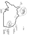
Figure 1 is a diagram that illustrates a relationship between a master version of a
geographic database and a coverage area.
Figure 2 is a block diagram showing a first embodiment of a system for facilitating
use of geographic data in developing computer games.
Figure 3 is a block diagram showing components of a system used by the computer
game developer of Figure 2.
Figure 4 is a block diagram showing components of the geographic API and
geographic data tools programs of Figure 3.
Figure 5 is a block diagram showing another embodiment of a system for facilitating
use of geographic data in developing computer games.
Figure 6 is a block diagram showing still another embodiment of a system for
facilitating use of geographic data in developing computer games.
Figure 7 is a block diagram showing components of a system used by the computer
game developer of Figure 6.
DETAILED DESCRIPTION OF THE
PRESENTLY PREFERRED EMBODIMENTS
I. INTRODUCTION
The embodiments disclosed herein relate to computer games that depict real
geographic locales as part of the play scenarios of the computer games. For example, the
play scenarios may involve a car chase through the streets of Miami, Florida, a treasure
hunt through Europe, a flight simulator game over Texas, and so on. In the embodiments
disclosed herein, geographic data used in the computer games is obtained from a map data
developer. In these embodiments, the map data developer collects, confirms,
updates, processes and distributes geographic data for other, non-game related purposes,
such as the provision of geographic data for navigation-related purposes.
II. SOURCE GEOGRAPHIC DATABASE.
Figure 1 shows a master or source version of a geographic database 100. The
master version of the geographic database is owned and developed by a geographic
database developer 101 (also referred to as a "map developer", a "map data developer" or
the like). (Although only one source database and geographic database developer are
shown, the embodiments disclosed herein are not limited to only a single source database
or a single geographic database developer.)
The master version of the geographic database 100 contains data 102 (also
referred to a "geographic data" or "spatial data") that represent geographic features in a
coverage area 104. The coverage area 104 may correspond to an entire country, such as
the United States. Alternatively, the coverage area 104 may correspond to several
countries, such as the United States, Canada, and Mexico, or France, Germany, and Italy,
and so on. According to another alternative, the coverage area 104 of the master version
of the geographic database 100 may represent only a single region within a country, such
as the West Coast or the Midwest of the U.S. Although the master version of the
geographic database 100 includes data that represent geographic features in the entire
coverage area 104, there may be parts of the coverage area 104 that contain geographic
features that are not represented by data in the geographic database, or for which the
representation of geographic features is sparse.
The master version of the geographic database 100 includes data about a road
network 120 located in the coverage area 104. The data about the road network 120
include various kinds of information, such as the geographic coordinates of positions of
the roads, street names of the roads, addresses ranges along the roads, turn restrictions at
intersections of roads, and so on. The master version of the geographic database 100 also
includes data about points of interest in the covered area 104. Points of interest may
include hotels, restaurants, museums, stadiums, offices, automobile dealerships, auto
repair shops, etc. The master version of the geographic database 100 may include data
about the locations of these points of interests. The master version of the geographic
database 100 may also include data about places, such as cities, towns, or other
communities, and other geographic features, such as bodies of water, mountain ranges,
etc. The master version of the geographic database 100 may include other kinds of
information.
There are different ways used by the geographic database developer to collect
data. These ways include obtaining data from other sources, such as municipalities. In
addition, the geographic database developer may employ field personnel to travel by
vehicle along roads throughout the geographic region to observe features and record
information about them. The data collected by the geographic database developer are
stored in the master version of the geographic database 100.
The geographic database developer 101 continues to collect data that represent the
features in the geographic coverage area 104 on an ongoing basis. One reason that the
geographic database developer continues to collect data is that the features in the
coverage area 104 change over time. Accordingly, the geographic database developer
collects data about the same features in order to update or confirm the previously
collected data about the features. Another reason that the geographic database developer
continues to collect data is to expand the coverage and/or detail of the master version of
the geographic database 100. For example, at one point in time the master version of the
geographic database 100 may include data that represents only a portion of the entire
coverage area 104. After that point in time, the geographic database developer collects
data about features in areas that were not previously represented in order to expand the
coverage of the master version of the geographic database 100.
The master version of the geographic database 100 is maintained as the copy that
has the most up-to-date data relating to the coverage area 104. Accordingly, the master
version of the geographic database 100 is updated, expanded, and/or otherwise modified
on a regular and continuing basis. To facilitate these operations, the master version of the
geographic database 100 is stored in a format that facilitates updating, maintenance, and
development. For example, the data in the master version 100 may be uncompressed.
Examples of suitable formats include the VSAM fonnat and the GDF format, although
other kinds of formats, both proprietary and non-proprietary, may be suitable. In general,
the format of the master database 100 is not suitable for use in navigation systems.
A copy of the master version of the geographic database 100 is physically located
at a first location 114. In one embodiment, the master version of the geographic database
100 is stored on one or more hard drives, tapes or other media, and accessed with an
appropriate computer 116. Any suitable computer may be used, such as a mainframe
computer, a plurality of networked microcomputers, etc.
III. FIRST EMBODIMENT
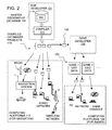
Figure 2 shows an overview of a first embodiment of a system and method for
facilitating the development of computer games that include representations of actual
geographic features, such as roads, in a geographic area. In Figure 2, the master version
of the geographic database 100 is used to make compiled database products 110. The
compiled database products 110 are made using a compiler 111. The compiler 111 is a
software program run on an appropriate computer platform.
The compiled database products 110 may include only portions of all the data in
the master version of the geographic database 100. For example, the compiled database
products 110 may include data that relate to only one or more specific sub-areas within
the coverage area 104 of the master version of the geographic database 100. Further, the
compiled database products 110 may include fewer than all the data attributes that
describe geographic features represented in the master version of the geographic database
100.
The compiled database products 110 are used on various kinds of computing
platforms. For example, the compiled database products 110 are used in computing
platforms 112 used for navigation. The computing platforms 112 used for navigation
include in-vehicle navigation systems, hand-held portable navigation systems, personal
computers (including desktop and notebook computers), and other kinds of devices, such
as personal digital assistant (PDA) devices, pagers, telephones, etc. The compiled
database products 110 are also used on networked computing platforms and
environments, including systems connected to the Internet.
The compiled database products 110 that are used in computing platforms used
for navigation are stored on suitable media. For example, the compiled database products
may be stored on CD-ROM disks, hard drives, DVD disks, flash memory, or other types
of media that are available now or that become available in the future.
On the computing platforms 112 used for navigation, the compiled database
products 110 are used by various software applications. For example, the compiled
database products 110 may be used by software applications that provide navigation-related
functions, such as route calculation, route guidance, vehicle positioning, map
display, and electronic yellow pages, as well as other kinds of functions.
In addition to producing compiled database products for use on computing
platforms used for navigation, the geographic database developer 101 produces one or
more compiled database products 118 for use by a computer game developer 130. The
compiled database product 118 used by the computer game developer may be the same as
or similar to the compiled database products 110 used in the computing platforms 112
used for navigation. The compiled database product 118 used by the computer game
developer 130 may be provided on a suitable media, such as one or more CD-ROM disks,
DVD disks, or hard drives. Alternatively, the compiled database product 118 used by the
computer game developer 130 may be provided over a network connection.
The computer game developer 130 uses data from the compiled geographic
database 118, along with other data and components (as explained below), to create one
or more computer games 132. The computer games 132 created by the computer game
developer 130 may include some or all the data from the geographic database 118.
Alternatively, the computer games 132 may include data derived from or based on the
data from the geographic database 118. The geographic data in the computer game 132
may be in a different format than the data contained in the geographic database 118.
The computer games 132 created using the data from the geographic database 118
provide for representing geographic features in play scenarios of the computer games.
The geographic features represented by the computer games include features located in
some or all the coverage area of the geographic database 118, including some or all the
road network represented by the geographic database 118. The computer games 132 are
installed on appropriate computer platforms 134. The computer platforms 134 on which
the computer games 132 are installed may include personal computers, game consoles,
PDAs, handheld game devices, mobile phones, networked computers, and so on. Users
access the computer games 132 on the computer platforms 134 to play the games.
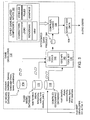
Referring to Figure 3, the computer game developer 130 uses a tool set 139. In
one embodiment, the tool set includes a geographic data API (application programming
interface) 140 and geographic data tools 144 to access and use data contained in the
compiled geographic database 118. In one embodiment, the geographic database API
140 and data tools 144 are similar or identical to the interface layer and related navigation
applications described in U.S. Pat. Nos. 5,974,419, 5,953,722, 5,968,109 and 6,047,280,
the entire disclosures of which are incorporated by reference herein. In general, the
geographic data API 140 provides a library of functions that facilitate accessing the data
contained in the compiled geographic database 118.
The geographic data API 140 and data tools 144 provide various ways that the
data in the geographic database 118 can be accessed. Some of these ways the geographic
data API 140 and data tools 144 provide for accessing the geographic database 118
include the following:
A. Spatial
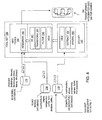
Referring to Figure 4, among the functions provided by geographic data API 140
and data tools 144 is a spatial search function 150. The spatial search function 150
supports spatial queries. Spatial queries return data records of a specified type (e.g., data
that represent road segments) based on location criteria included in the query. For
example, a spatial query may request all the data records that represent road segments
that are within 5 km of a given latitude and longitude. Another spatial query may request
all the data records that represent restaurants that are within a rectangular area having
specified geographic boundaries. The spatial search function 150 returns all the data
records that meet these criteria.
B. Extraction (slicing)
The geographic API 140 and data tools 144 provide an extraction function 154.
The extraction function 154 supports extraction of slices of data from the geographic
database 118. The game developer 130 may want to make a computer game that
provides for representation of only a portion of the coverage area of the geographic
database 118. As an example, the geographic database 118 may have a coverage area of
Florida (i.e., includes data that represents the entire state of Florida); however, the game
developer 130 wants to make a computer game in which a game player can virtually
drive along only the streets of Miami. Using the extraction function 154, the game
developer 130 can extract from the geographic database 118 the data that represents only
the city of Miami.
C. Filter
The data in the geographic database 118 may be provided with a high level of
detail and/or accuracy. For example, the data in the geographic database 118 may
represent the locations of roads in a geographic region with a level accuracy of ± 5
meters. This high level of detail is appropriate for navigation-related functions, such as
vehicle positioning. However, providing a high level of detail requires a relatively large
amount of data. For many computer games, a high level of detail may be unnecessary.
Reducing the level of detail and/or accuracy reduces the amount of data needed to
represent a geographic area. Furthermore, reducing the level of detail and/or accuracy
may also facilitate processing of the data.
Accordingly, another function provided by the geographic API 140 and tools 144
is a filter function 158. The filter function 158 filters the geographic data obtained from
the geographic database 118. The filter function 158 selectively eliminates portions of
the geographic data obtained from the geographic database 118, while maintaining a
given coverage area. According to one embodiment, the filter function 158 eliminates
some of the data used to represent the shape of road segments (e.g., shape point data).
The shape data are thinned out so that the entire road is still represented, but not
necessarily with the same level of accuracy. For example, instead of representing a road
with a level of accuracy of ± 5 meters, the filter function 158 deletes shape point data so
that the road is represented with a level of accuracy of ± 25 meters. This reduction in
accuracy results in a corresponding decrease in the amount of data needed to represent a
geographic area. In another embodiment, the filter function 158 can be operated to
eliminate entire classes of roads, such as all side streets.
Using the filter function 158, the game developer can obtain data from the
geographic database that suitably represents a geographic area, without having more data
than is needed to represent a geographic area with the desired level of detail and/or
accuracy for purposes of the computer game. This may have a favorable effect on data
storage requirements for the computer game and may improve game performance, i.e., so
that the game is able to realistically simulate movement through the represented area at a
desired simulated speed.
The filter function 158 may also be used by the game developer 130 to obtain
geographic data at different levels of detail for games on different platforms. For
example, a game developer 130 may use the filter function 158 to obtain geographic data
with a relatively high level of accuracy for a console platform game, and use the filter
function 158 to obtain another set of geographic data with a relatively low level of
accuracy for a handheld platform game.
D. 3D conversion
The geographic API 140 and data tools 144 also include a 3D conversion function
161. The 3D conversion function 161 supports conversion of the data obtained the
geographic database 118 so that it can be displayed as a 3D (perspective view) image.
The 3D image may represent the geographic area from the point of view of the game
player or may be from the point of view of another, e.g., a spectator. The view may be an
overhead view. (This 3D function may be incorporated here in the geographic API 140
and data tools 144 or may be incorporated into the other game-related components and
inputs 190, described below.)
E. Transformation
The geographic API 140 and data tools 144 also include a transformation function
160. The transformation function 160 converts the data obtained from the geographic
database 118 into a different format. The different format may be one that is suitable for
use by computer games. For example, the data may be transformed so that it is more
suitable for 3D display. As another example, the data may be transformed so that it can
be rendered quickly, i.e., to simulate a vehicle moving at high speed. According to
another example, the data may be transformed so that it is more suitable for use with online
games, e.g., Internet games.
F. Integration
The geographic API 140 and data tools 144 include an integration function 164.
The integration function 164 provides for associating data obtained from the geographic
database 118 with other, new types of data. Among the new types of data that are
associated with the geographic data are road models and 3D models. The road models
and 3D models are stored in a road model database 170 and a 3D model database 174,
respectively.
The data in the road model database 170 are representations used for visual
appearance and rendering of road-related things, such as road pavement, lane stripes,
curbs, sidewalks, signs, lampposts, lane dividers, traffic signals, speed bumps,
crosswalks, and so on. These road model representations are associated with data
representation of the road network obtained from the geographic database 118. As stated
above, the data in the geographic database 118 is (or is derived from) a representation of
a road network used for navigation. As such, the data in the geographic database 118
may not indicate what roads, or things associated with a road, look like. For example, in
the geographic database 118, a data representation of a road for navigation purposes may
indicate the locations (e.g., geographic coordinates) of intersections, and possibly the
locations of points along a road segment between intersections, the legal (and illegal)
connections between roads, the names of roads, the addresses ranges along roads, the
type of road surface, and so on. However, in the database 118 a data representation of a
road for navigation purposes may not contain information that indicates the actual visual
shapes, colors, dimensions, etc., of these road-related things. For example, in the
database 118 a data representation of a road for navigation purposes may not indicate the
colors of a road, curbs, sidewalks, what a sign looks like, and so on. The road model
database 170 includes these types of information.
The integration function 164 provides for associating data in the road model
database 170 with data from the geographic database 118 that represents the road
network. The integration function 164 may associate road model data with specific
locations along a road segment (as represented by data from the geographic database 118)
or with lengths along a road segment. As an example, the integration function 164 may
provide for showing curbs (using a model for what a curb looks like from the road model
database 170) along all side streets (represented by data from the geographic database
118). In another example, the integration function 164 may provide for showing barriers
along all the sides of expressways (using a model for barriers from the road model
database 170) as represented by data from the geographic database 118. The integration
function 164 may also provide for associating data models for traffic signals at
intersections.
The data representations of road-related things in the road models database are
also used for providing other properties of the represented things, such as the physical
and audio properties. For example, causing a simulated vehicle to move over a simulated
curb causes the simulated vehicle to "bump." Similarly, a simulated vehicle "hitting" a
simulated lamppost causes a simulated crashing sound. The data representations from the
road models database can also be used for providing feedback to the player via the user
interface, if supported.
The road model database 170 may include a variety of different data models for
some types of road-related things. For example, there may be a number of different types
of traffic signal configurations. These different types of traffic signal configurations are
used to provide variety and to make the representation of the road network appear more
realistic, i.e., so that all the traffic signal configurations do not look the same.
The game developer uses the integration function 164 to combine data from the
road model database 170 with data from the geographic database 118 to provide a
realistic appearing and acting road network. The road model database 170 is not intended
to represent the actual road-related things, such as the exact locations of or text on signs,
or the exact configuration of traffic signals, etc. Neither the geographic database 118 nor
the road model database may contain information that represents the actual location of
signs or the exact configuration of traffic signals. However, the road model database 170
provides data for visually representing these road-related things in a manner that would
be typical for the geographic area. So, for a residential neighborhood, the road model
database would include models for sidewalks, cross walks, stop signs, etc., which would
be associated with appropriate locations along the road network as defined by the
geographic database 118. The integration function 164 and the road model database 170
provide for both the density (how many signs per mile or how many lampposts per block)
and the style (shape, height, sign text wording) of these road related things.
As mentioned above, the integration function 164 associates data from the 3D
model database 174 with the road network represented by the geographic database 118.
The 3D model data in the 3D model database 174 includes representations used for visual
appearance and rendering of cityscape- and landscape-related things, such as buildings
fences, trees, shrubbery, lawns, fences, clouds, scenery, and so on. Like the road models,
these 3D model representations are associated with locations along the road network data
as represented by data from the geographic database 118.
The data representations of cityscape and landscape-related things in the 3D
models database are also used for providing the other properties (e.g., physical and audio)
of the represented things. For example, causing a simulated vehicle to strike a simulated
building causes the simulated vehicle to stop and make a crashing sound. As another
example, a simulated vehicle can drive over a simulated shrub, but not a simulated tree.
After the geographic database developer 130 has used the API 140 and
geographic data tools 144 to extract, transform, filter, and integrate the data from the
database 118 with the data from the road model database 170 and 3D model database
174, as appropriate, a data product 184 representing a geographic area and suitable for
use in a computer game is produced.
Referring again to Figure 3, the game developer 130 uses the data product 184 in
making a computer game 134. The game developer 130 combines the data product 184
produced using the API 140 and geographic tools 144 with other game-related
components and inputs 190. Among the other game-related components and inputs 190
are data and programs that provide and/or represent characters, game logic, vehicles (both
for the first person game player as well as others), and game rules. The other game-related
components and inputs 190 also include programs for rendering and graphics.
The other game-related components and inputs 190 may also include components (e.g.,
applications, programs, etc.) that make specific use of the geographic data, such as a
route calculation application that determines a route that can be used as part of the play
scenario of the game. The development of some computer games may include additional
components and/or inputs whereas other computer games may require fewer. Creation
and development of these game-related components and inputs are known to those of
skill in the art. The game developer 130 combines the data product 184 produced using
the API 140 and geographic tools 144 with the other game-related components and inputs
190 using a suitable linker and/or compiler 194. In the data product, the geographic data
may be integrated into the code base or may exist separately. The computer game 134
produced by the computer game developer 130 is distributed (and/or sold or licensed) to
end users using any suitable distribution channels.
IV. SECOND EMBODIMENT
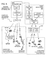
Figure 5 shows another embodiment of a system and method for facilitating the
development of computer games that include representations of actual geographic
features, such as roads, in a geographic area. In Figure 5, like components are indicated
by the same numerals as in the previous embodiment. The system and method of Figure
5 are similar to the system and method of Figure 2 with the exception that the game
developer 130 receives geographic data from the master geographic database 100 instead
of from one of the compiled geographic databases 110, 118 produced from the master
geographic database 100. In order to access data from the master geographic database
100, the game developer 130 uses an interface 200. The interface 200 is different from
the API 140 (in Figure 4) insofar as it provides for accessing geographic data in the
uncompressed format in which it is stored in the master geographic database 100. This
may affect the performance of the interface 200. However, this may not be a significant
factor in a development environment. In other respects, the embodiment of Figure 5 is
similar to the embodiment of Figures 2-4.
V. THIRD EMBODIMENT
Figure 6 shows another embodiment of a system and method for facilitating the
development of computer games that include representations of actual geographic
features, such as roads, in a geographic area. In Figure 7, like components are indicated
by the same numerals as in the previous embodiment. The system and method of Figure
7 are similar to the system and method of Figure 2 with the exception that the map
developer 101 provides compiled geographic database products 220 which are suitable
for use in computer platforms for games 134. These compiled geographic database
products 220 are then distributed to end users who use the compiled geographic database
products 220 in their computing platforms for games 134. The compiled geographic
database products 220 may be distributed directly from the map developer 101 to the end
users or alternatively, the compiled geographic database products 220 may be distributed
through the computer game developer 130 or another third party.
In this embodiment, the computer game developer 130 develops computer games
234 that use the separately provided geographic database products 220. Figure 7 is a
block diagram showing components of this embodiment. The components shown in
Figure 7 are similar to those in Figure 4 with the exception that the computer game
developer 130 does not include the geographic data from the map developer 101 in the
game. Instead, the computer game developer 130 provides data from the road model
database 170 and the 3D model database 174 along with the other game-related
components and inputs 190 in a game 234. The game 234 is created in a way that it
accesses a compiled geographic database 220 on the end user's computer platform 134.
The end user's game platform 134 includes an appropriate API (which may be similar to
the API 140 described in connection with Figure 3). An advantage of this embodiment is
that end users may be able to obtain different compiled databases, representing different
geographic areas, from the map developer 101.
VI. OTHER EMBODIMENTS
The embodiments disclosed herein describe use of geographic data in computer
games. The embodiments disclosed herein can be adapted for using geographic data for
other non-navigation-related purposes. Among these other, non-navigation purposes are
simulations and movie making. For example, the embodiments disclosed herein can be
adapted for using geographic data for simulation systems. Simulation systems that can
use geographic data include systems that simulate emergency operations (such as
evacuation procedures or emergency vehicle deployment and routing), driver education
systems, etc.
The embodiments disclosed herein can also be used in movie making. Many
movies use computer-generated images of real (or imaginary) locations, instead of actual
images. The embodiments disclosed herein can be adapted for creating realistic-looking
geographic locations, including features such as road networks, for use in movie making.
When using any of the disclosed embodiments for movie making, a relatively high visual
accuracy may be required and therefore attributes that provide for relatively high visual
accuracy may be needed. However, fewer attributes of some types may be required.
The embodiments disclosed herein can be used on various different types of
computer platforms, including client-server platforms and peer-to-peer platforms. The
embodiments disclosed herein can be used with streaming or other technologies.
The embodiments disclosed herein may also be used for games that use
geographic data obtained from multiple sources, e.g., more than one source geographic
database. In these embodiments, the data from the multiple source geographic databases
may be combined by the game developer or by another party.
VII. EXAMPLES
The following are examples of different types of computer games and/or
applications that can be developed using the disclosed embodiments. (Note that some of
the games are new and some are updates and/or improvements of prior games.)
A. City development simulation game
Geographic data that represents actual, real-world locales can be used in a type of
computer game in which players simulate growth of an urban (or other regional)
environment. In this kind of game, players simulate building cities or other places (such
as towns, countries, rural areas) by designing roads, utilities (e.g., electrical, sewage,
water) and other infrastructure elements for a geographic area. Then, the computer game
allows a virtual city to develop based on the designs. The virtual cities can be detailed
including individual zoning requirements (e.g., residential, commercial, industrial, etc.),
crime layers (i.e., that can be changed by implementing police stations), traffic,
unemployment and other realistic features.
Geographic data that represents actual, real-world locales can be used in this type
of game to provide a high level of realism thereby allowing game players to build cities
based on real world city models. In this type of game, players may choose a specific city
model (e.g., Paris), and attempt to improve or replicate it. The inclusion of real time
traffic, weather, points of interest (periodically updated or real time) and other real world
content would serve to increase the realism of such a virtual city. This improvement
could add realism, player loyalty, recognition, and an alternative goal to this popular type
of game.
B. Virtual person development simulation game
Geographic data that represents actual, real-world locales can be used in a type of
computer game in which game players simulate development of a virtual person (e.g., a
"sim''). In this kind of computer game, players build a virtual person by managing that
virtual person's habits, tendencies, house, family, job and interactions with other virtual
people. In prior simulation games of this type, the locales in which virtual people live
were non-specific. In prior simulation games of this type, the locales were modeled from
the view of the player's virtual house and may have included some features specific to
the game manufacturer.
Data from a source of geographic data that represents actual, real-world locales
can be used in this type of game to provide a high level of realism, thereby allowing
players to build virtual characters in models of real cities, with models of actual real-world-points
of interest, streets, landmarks and neighborhoods. When starting this type
of game, which has been enhanced by the addition of geographic data that represents
actual, real-world locales, a player chooses a real world city. Once the city has been
chosen, neighborhoods from the city become available for the player to select (e.g.,
Chicago's Gold Cost, Lincoln Park, Rogers Park, River North, or specific suburbs).
Once the player selects a neighborhood, the player's virtual person would be able to
simulate visits to virtual attractions based on real world local attractions, e.g., go to
popular restaurants and bars, work in local businesses, and reflect how life is lived in that
specific area almost as if he/she were living there.
C. "Bot-fighter" game
Geographic data that represents actual, real-world locales can be used as a
backbone for a "bot-fighter"-type game. This enhances the bot-fighter-type game by
incorporating detailed spatial data that represents real world locales. A "bot-fighter"-type
game can be played on mobile phones. In this game, players build "warrior robots" on
their mobile phones using credits (e.g., virtual money) from battles won against other
players. All firing between warriors is done via SMS messaging over the mobile phones.
With mobile phone technology, a player may be given rough coordinates to his or her
player-enemies or be warned when a player-enemy has entered his/her area or turf via
mobile phone positioning technology.
The addition of geographic data that represents actual, real-world locales can give
this type of game greater appeal. Specific route data and location details or spotting
could be provided instead of simple proximity alerts. The addition of geographic data
that represents actual, real-world locales would enable this type of game to support more
precise boundaries. Further, with the addition of geographic data that represents actual,
real-world locales, a game player's weapons could be given more accurate range
limitations, rather than rough limitations available with existing games.
In addition, game credits (e.g., virtual money) could be spent on routes, enemy
interception (based on known movements or historical patterns) courses, or enemy
spotting locations.
D. Traffic management game/application
In this computer game/application, data that represents the road network in the
real world is used in combination with traffic feeds and models in order to simulate a real
city with its existing traffic patterns. Once a model of an actual city with its road network
and traffic patterns is created, predictive modeling and comparisons to other cities allow
the user to tweak, re-model, or re-design traffic architecture to improve the road network
with the objective to create the most efficient traffic system or to make the most
improvements to an existing system.
This computer game/application can include a vehicle fleet management feature.
According to this feature, the game player is given a virtual fleet of vehicles (e.g., starting
with two trucks) in an initially chosen city and an overlay of existing traffic conditions.
The goal of the game with the fleet management feature would be to provide service to a
customer base (i.e., based on real world businesses represented in the real world
geographic database and some zoning data). Time of day for delivery, fleet routing, fuel
expenditures, pickup points and schedules etc., would all be managed by the game player.
Traffic flow, incidents, bottlenecks and other traffic data would be displayed.
Wired or live devices would also have the ability to add live or updated data. Traffic
would be made up from individual vehicles, following typical vehicle movement patterns
(e.g., gapers, cars driving down the shoulder, etc.) or could be built from scratch.
E. Emergency services and law enforcement games
Geographic data that represents actual, real-world locales can be used in
emergency services scenario-type games or law enforcement scenario-type games. These
games include themes related to fire fighting, medical emergency services (e.g.,
ambulance, search and rescue), police chases, etc. Game developers who make these
kinds of games can use the disclosed embodiments to provide realistic looking locales,
possibly with the addition of location-based content (e.g., actual buildings, businesses
etc.), traffic, weather, points of interest, etc., as part of the playing scenarios of these
games.
F. Location quiz game
Geographic data that represents actual, real-world locales can be used in a
location quiz-type of computer game. In this type of game, game players are provided
with clues about a game character's secret location and attempt to determine the secret
geographic location. Using geographic data that represents actual, real-world locales
adds a measure of realism to this type of game and increases its educational value.
One feature of this game is the ability to personalize the game to a player's locale.
Players would be able to search for the secret location in their own city or neighborhood.
For example, parents could use the game to teach their children how to get around in their
own neighborhoods. According to this example, parents could set up the game to include
the route that their child takes to and from school. Also, if a family moves to a new
neighborhood, the parents could obtain up-to-date digital map data that represents the
new neighborhood in order to teach their children about the new neighborhood.
Adding digital map data to the game would also provide the capability to play it
anywhere the player is located. For example, a child from Chicago who is on vacation in
Paris could search for the game character in Paris and thereby learn about the city.
G. Children's atlas
Another computer game/application that can use geographic data that represents
actual, real-world locales is a children's atlas game/application. This computer
game/application can be used by families on long car trips. In one embodiment, this
game/application could be used to answer children's questions such as "Are we there
yet?" or "Where are we?" with distances and times to destinations.
One version of this game includes a communications feature that allows a child to
communicate with other children who have games with the same feature. Another
version of this game/application allows a game player to create a virtual travelogue that
describes and records travels in real time.
In one embodiment, a children's atlas game/application would be developed as a
travel companion game that obtains location information from an in-vehicle navigation
system or remote server. As a car in which the child is a passenger drives through a
specific locale (e.g., a town or attraction) or a more general area (e.g., a state), the
children's atlas application would display images and use voice narration to provide facts
about the area. The children's atlas game/application would also provide well-known
stories or legends about an area (e.g., Johnny Appleseed as the child is traveling through
the Appalachians).
In another alternative embodiment, the children's atlas includes a travel pal
feature. This feature allows a child traveling through an area to connect online with other
children who located in the area. In one version of this feature, children can
communicate with other traveling children or with other children located in the area a
child is passing through using instant messaging. A buddy list may be formed and used
for this purpose. Children could access this service while traveling or at home. For
example, children could exchange information about their travels or play games.
Children passing through a particular place could instant message with children living in
the area and ask questions about the area, e.g., what do the locals think about the best
places to eat, what is the best radio station, etc.
According to another alternative embodiment, the children's atlas application
includes a virtual travelogue feature. The virtual travelogue feature allows a child to
collect, store, and send information about his or her travels as a trip is taking place. The
child could take information provided by the atlas game/application, annotate it with
personal experiences and observations, and send it to friends and relatives, or to a home
website that eventually turns into a scrapbook of the entire trip (or perhaps a report on a
school field trip), complete with maps, pictures and postcards from the area, voice
narration, and any other data collected along the way.
The virtual travelogue feature could also catalogue and automatically store every
place the child has traveled. The child could then display or print out a map that shows all
the places he or she has been and how he or she got there.
H. Simulated tour
Another application that can use geographic data that represents actual, real-world
locales is a simulated tour application. This simulated tour application uses geographic
data, POI data, 3D modeling, and other data, such as weather, traffic, crime statistics, and
restaurant guides, to build a realistic view of a city or other locale for virtual touring. The
simulated tour application could be used by people considering moving to a new area, or
could be hosted by realtors, or used by travelers, or simply used by individuals to learn
more about different locations.
With this application, one can learn, understand, explore, or market a specific
area. This application would portray an area visually, textually, and possibly even
audibly. Smells (e.g., heavy fog, chocolate factory nearby - pervasive) could be provided
using appropriate technology or described textually.
One use for this application is to provide a way for a person to become familiar
with driving in an unfamiliar city. Some cities may have driving conventions that are
unfamiliar to some people. For example, speed limits are painted on the road in
California and Hawaii whereas they are located on little signs in Illinois. According to
another example, traffic is particularly aggressive in Rome and lanes are viewed as
guidelines, not rules etc.
I. Car rally challenge game
Another computer game that can be improved using geographic data that
represents real world places is a car rally challenge-type game. This game can be played
in single player or multi-player versions. In this type of game, teams of game players
travel actual routes that are sent to them from a central server. The server would store a
number of car rally routes and attribute scenarios (e.g., points of interest as checkpoints)
for a specific area (e.g., state, city, neighborhood, etc.), and these virtual rally instructions
would be sent to the participating drivers and navigators.
An organizer's kit could also be offered that would cater to amateur car rally
organizations or clubs. The kit would allow an individual or organization to create a
customized car rally specific to a city or area. The rally information could be created on
the rally organizer's personal computer within a program, or via download from a
website. It could then be printed out and handed to the racers or downloaded to a device
such as a PDA.
The difference between the game and the kit is that the game would send out predetermined
routes and rally features. The routes and features might change regularly but
the players would not have a hand in planning or creating the rally scenarios.
The kit would provide the basic tools and content to create a rally, thereby allowing the
user to add local flavor, degrees of difficulty, or to even recreate a well-known rally
course.
J. Location-based virtual monopoly game
Geographic data that represents real world places can be used in a computer game
based on the Monopoly board game. In one version of this game scenario, a game
player's positions and movements in the real world are tracked, using positioning
equipment such as GPS, cell phone triangulation, etc. These movements would be used
to define game routes for that player. Then, the routes would be used to identify
properties (e.g., actual or fictional) along that route the game player could virtually
purchase, rent, etc., as in the classic board game. Real world conditions, such as traffic
restrictions, road construction, tolls, etc., would be factored into the game play scenario.
K. Promotional games and contests
Geographic data that represents real world places can be used for promotional
concepts (e.g., contests, sales events, and so on). Businesses, such as retailers or
restaurant franchises, frequently use special promotions or contests to attract business.
Adding location-based data and services to these promotions would allow businesses to
better target, reach, and track potential customers, and also add an extra dimension.
Promotional tie-ins to location-based data could be developed using a variety of
approaches.
L. Spatial simulator for exercise
Data that represents actual, real world places can be used with sports or exercise-related
events or equipment. For example, geographic data can be used to enhance
simulators (e.g., monitors) used on or with exercise equipment. Geographic data that
represents real places can be used with a treadmill or exercise bicycle to simulate the
experience of running or biking along a route. The route would be projected on a
monitor or screen in front of the person on an exercise machine such as a treadmill or
exercise bicycle.
Use of data that represents actual, real world places could allow users to feel as if
they were running through the streets of a major city, e.g., along a marathon or 10K
route, or biking the route of the Tour de France. The simulator could also be used to keep
track of long-term training goals, such as running virtually across the entire United
States.
A basic simulation would consist of a display of a basic overview map based on a
route. For example, the user would ask for a route within a city and a basic map would
be displayed showing the streets of the city with a mark on the map indicating the virtual
position of the runner or bicyclist. The runner's progress along the route would be based
on the runner's pace. The degree or category of simulation offered could vary depending
on the level of realism desired. For example, details such as road elevation could be
added to the simulation. This would allow the person exercising to experience the feeling
of running or biking in the Rocky Mountains or through the plains of Nebraska.
A detailed simulation would use 3D data and give a full picture on a monitor of
the buildings and landmarks along the route. This would give the runner or bicyclist a
realistic feeling of running or biking along the route.
M. Classic computer games
Geographic data that represents actual, real-world locales can be advantageously
used to make new versions of classic computer games like Snake and Pacman. In these
new versions of these games, game players assume the identities of characters in the
game. A player uses positioning equipment that determines the player's actual physical
position in the real world. The player also has equipment that provides for wireless
communication with a central database. This player becomes a virtual player in a classic
game such as PacMan or Snake. The games would be played in either an online
competitive mode or a single player (player versus machine) mode. In either case, the
player acts as a character in the game. The distance and speed moved by the player would
be translated to movement and speed in a virtual world, where the player may accomplish
goals within the game or defeat other players. The system would be set up in translated
"virtual boards" where a game would consist of an area regulated by the speed of
transportation (a "board" for a vehicle can be significantly larger than one for a
pedestrian).
N. Location based cannonball run car racing game
Another computer game that can use embodiments of the disclosed system and
method for providing geographic data is a "cannonball run" car racing game. This game
may be played in multi-player or single player mode. The multi-player mode game may
be played online. In the game playing scenario, players compete against each other to
race vehicles (e.g., cars, bikes, etc.) across a geographical area. Data that represent
actual, real-world places would be used to add realism to the game, e.g., actual legal and
physical restrictions. Alternative features include the addition of real-time traffic and
weather conditions.
One scenario for a multi-player online version of the game would feature a
community where players start out with a specific mode of transportation. This version
of the game would provide an online culture and goal of being with the best group and
driving the best vehicle. Players would start with a certain amount of virtual cash and a
basic vehicle. Some races would be pre-defined events, whereas other races would be
random city races with a user defined start and end points. The selection of routes for
races would be based on real map data. The game would be based on winning virtual
money by winning races, but winning a race could cost the player due to traffic tickets,
illegal traffic maneuvers or other expenses. All fines would be based on legal restriction
data and statistics of the percentage of drivers caught. Suggested routes would be
provided in all races, and the amount of virtual cash used to buy a route would vary the
quality or speed of the route.
Game players would have the option of racing through their hometowns, or
through the streets of their favorite cities or countries all over the world. These would
attract a larger demographic, and interest the casual game player as well.
O. Virtual trip planner and simulation
Data that represents actual, real world places can be used for a computer
simulation application that would allow a user to preview a trip or specific route by
virtually driving it on his or her personal computer or game console. The simulation
would be based on a representation of the geographic database that included 3D
renderings of buildings, signs, topographical features, and other related attributes. The
simulation software could be provided on media, through an online vendor, or rented to
users on an as-needed basis. Users would enter a route request via their personal
computers or consoles and could use gaming steering wheels, joysticks, voice commands,
or keyboards to drive the routes. A fast forward function could be used to skip the
obvious or mundane sections of the trip or to speed up the pace.
To make the simulation more realistic, traffic features, such as vehicles coming
and going on the route, could be included. These could perhaps even be based on actual
traffic patterns or real-time traffic for a selected time of day.
A feature of this simulation application would be as a form of trip planner. The
planner would provide information about an area to which one is traveling, such as local
history, area specific trivia games, and point of interest descriptions and
recommendations. Users would have the option of using this information while driving
the area in advance (e.g., using the simulation application, described above), printing out
the planner in advance as a reference, or loading it onto a device and accessing it during
an actual trip (e.g., going on a long trip and using the planner interactively to keep
children amused and informed). For example, if a family was traveling on vacation from
Chicago to Miami by car, the parents could research and preview the attractions, hotels,
and restaurants at which the family may want to stop along the way. They could also
preview the route and create their own form of trip ticket to plan the best route. The
parents could then set up an itinerary that would include games, information, quizzes etc.,
that would occupy the children throughout the trip.
It is intended that the foregoing detailed description be regarded as illustrative
rather than limiting and that it is understood that the following claims including all
equivalents are intended to define the scope of the invention.