EP1380021B1 - Verfahren zum betrieb eines navigationssystems fur ein fahrzeug - Google Patents
Verfahren zum betrieb eines navigationssystems fur ein fahrzeug Download PDFInfo
- Publication number
- EP1380021B1 EP1380021B1 EP02708235A EP02708235A EP1380021B1 EP 1380021 B1 EP1380021 B1 EP 1380021B1 EP 02708235 A EP02708235 A EP 02708235A EP 02708235 A EP02708235 A EP 02708235A EP 1380021 B1 EP1380021 B1 EP 1380021B1
- Authority
- EP
- European Patent Office
- Prior art keywords
- vehicle
- distance
- route
- decision point
- point
- Prior art date
- Legal status (The legal status is an assumption and is not a legal conclusion. Google has not performed a legal analysis and makes no representation as to the accuracy of the status listed.)
- Expired - Lifetime
Links
- 238000000034 method Methods 0.000 title claims description 25
- 238000012545 processing Methods 0.000 claims description 7
- 230000001133 acceleration Effects 0.000 claims 1
- 238000013459 approach Methods 0.000 description 4
- 230000005540 biological transmission Effects 0.000 description 4
- 238000010586 diagram Methods 0.000 description 3
- 230000000007 visual effect Effects 0.000 description 2
- 238000005259 measurement Methods 0.000 description 1
- 238000012544 monitoring process Methods 0.000 description 1
- 230000003287 optical effect Effects 0.000 description 1
- 238000012546 transfer Methods 0.000 description 1
Images


Classifications
-
- G—PHYSICS
- G08—SIGNALLING
- G08G—TRAFFIC CONTROL SYSTEMS
- G08G1/00—Traffic control systems for road vehicles
- G08G1/09—Arrangements for giving variable traffic instructions
- G08G1/0962—Arrangements for giving variable traffic instructions having an indicator mounted inside the vehicle, e.g. giving voice messages
- G08G1/0968—Systems involving transmission of navigation instructions to the vehicle
- G08G1/096805—Systems involving transmission of navigation instructions to the vehicle where the transmitted instructions are used to compute a route
- G08G1/096811—Systems involving transmission of navigation instructions to the vehicle where the transmitted instructions are used to compute a route where the route is computed offboard
-
- G—PHYSICS
- G01—MEASURING; TESTING
- G01C—MEASURING DISTANCES, LEVELS OR BEARINGS; SURVEYING; NAVIGATION; GYROSCOPIC INSTRUMENTS; PHOTOGRAMMETRY OR VIDEOGRAMMETRY
- G01C21/00—Navigation; Navigational instruments not provided for in groups G01C1/00 - G01C19/00
- G01C21/26—Navigation; Navigational instruments not provided for in groups G01C1/00 - G01C19/00 specially adapted for navigation in a road network
- G01C21/34—Route searching; Route guidance
-
- G—PHYSICS
- G08—SIGNALLING
- G08G—TRAFFIC CONTROL SYSTEMS
- G08G1/00—Traffic control systems for road vehicles
- G08G1/09—Arrangements for giving variable traffic instructions
- G08G1/0962—Arrangements for giving variable traffic instructions having an indicator mounted inside the vehicle, e.g. giving voice messages
- G08G1/0968—Systems involving transmission of navigation instructions to the vehicle
- G08G1/096805—Systems involving transmission of navigation instructions to the vehicle where the transmitted instructions are used to compute a route
- G08G1/096811—Systems involving transmission of navigation instructions to the vehicle where the transmitted instructions are used to compute a route where the route is computed offboard
- G08G1/096822—Systems involving transmission of navigation instructions to the vehicle where the transmitted instructions are used to compute a route where the route is computed offboard where the segments of the route are transmitted to the vehicle at different locations and times
-
- G—PHYSICS
- G08—SIGNALLING
- G08G—TRAFFIC CONTROL SYSTEMS
- G08G1/00—Traffic control systems for road vehicles
- G08G1/09—Arrangements for giving variable traffic instructions
- G08G1/0962—Arrangements for giving variable traffic instructions having an indicator mounted inside the vehicle, e.g. giving voice messages
- G08G1/0968—Systems involving transmission of navigation instructions to the vehicle
- G08G1/096855—Systems involving transmission of navigation instructions to the vehicle where the output is provided in a suitable form to the driver
- G08G1/096861—Systems involving transmission of navigation instructions to the vehicle where the output is provided in a suitable form to the driver where the immediate route instructions are output to the driver, e.g. arrow signs for next turn
-
- G—PHYSICS
- G08—SIGNALLING
- G08G—TRAFFIC CONTROL SYSTEMS
- G08G1/00—Traffic control systems for road vehicles
- G08G1/09—Arrangements for giving variable traffic instructions
- G08G1/0962—Arrangements for giving variable traffic instructions having an indicator mounted inside the vehicle, e.g. giving voice messages
- G08G1/0968—Systems involving transmission of navigation instructions to the vehicle
- G08G1/096855—Systems involving transmission of navigation instructions to the vehicle where the output is provided in a suitable form to the driver
- G08G1/096872—Systems involving transmission of navigation instructions to the vehicle where the output is provided in a suitable form to the driver where instructions are given per voice
Definitions
- the invention relates to a method for operating a navigation system for a vehicle, for a motor vehicle in which determined by a location system data on the geographic position and to an electronic data processing device with access transferred to a database and a digital road map and based on this data the location of the vehicle on the digital Road map is determined and the driver of the vehicle Acoustic and / or visual route guidance instructions are issued.
- a method for operating a navigation system for a vehicle for a motor vehicle in which determined by a location system data on the geographic position and to an electronic data processing device with access transferred to a database and a digital road map and based on this data the location of the vehicle on the digital Road map is determined and the driver of the vehicle Acoustic and / or visual route guidance instructions are issued.
- a method is known from EP-A-629 840 known.
- Navigation systems for vehicles especially motor vehicles, as well Methods for operating such navigation systems are known. These are used to determine the current geographic position of the Determine vehicle and depending on a predetermined, too relevant destination to calculate the cheapest route and give the driver instructions on the route.
- the known navigation systems require information for the Determination of the current location of the vehicle and the calculation the route are necessary. These include in particular Road courses, turning conditions and the like. These dates are stored in the form of a database, for example one CD-ROM, kept in the vehicle.
- the database includes this for example a so-called digital map, the waypoints and / or contains decision points of the possible routes.
- a location system which is the current geographical Determines the position of the vehicle.
- This is known, for example the satellite-based Global Positioning System (GPS).
- GPS Global Positioning System
- a The facility for electronic data processing processes the data from Positioning system delivered position data with those in the digital road map stored data and determines the current position of the Vehicle. According to the selected target point you can now through the facility for electronic data processing based on Waypoints and / or decision points on a selected one cheapest route to the driver visually and / or acoustically Route guidance information is given.
- map matching compare the information for operating a navigation system various sensors for determining the position of the vehicle (e.g. via GPS), the direction of travel of the vehicle (e.g. via gyrocompass) and a driving speed of the Vehicle (for example via speed sensors) with the Information of the saved digital map. Since the sensors in are usually afflicted with measurement errors, these are and direction information of the digital map are compared and corrected. The content of a digital one is therefore used to correct the sensors Map with the highest possible resolution (fine geometry or shape points) necessary.
- the invention has for its object a method for operation a navigation system for a vehicle, in particular a motor vehicle, and improve navigation system.
- the method according to the invention for operating a navigation system with the features mentioned in claim 1 offers the advantage that based on less information from a digital map and location information the vehicle's time-critical route guidance can be issued to a driver.
- a current distance of the vehicle from one first decision point of one to be driven by the vehicle Route is checked and if a minimum distance is exceeded of the vehicle after passing the first decision point next decision point is determined, is advantageously possible
- the method is based on Distance checks, especially for changes in a distance based on decision points, is a simple Processing of data possible, so that the navigation system as a whole can be operated with little effort.
- the received distance information or received information about changing a distance to decision points for checking compliance with a given cheapest Route can be used. This advantageously makes additional possible Output information to the driver that he the cheapest route to reach the destination specified by him has left. Furthermore, this advantageously makes it possible accordingly a route change made by the driver to determine a new cheapest route and this the other Based on route guidance.
- FIG. 1 schematically shows a navigation system designated overall by 10 for a motor vehicle.
- the navigation system 10 comprises a device 12 for electronic data processing, which in detail microprocessors, memory elements or not shown the like.
- the navigation system 10 further includes a location system 14, for example a global known per se Positioning system (GPS).
- the device 12 is a mass storage device 16, for example a CD-ROM, and / or a receiving device 18 assigned.
- the receiving device 18 communicates via a Transmission path 20 with a higher-level, stationary service center 22. Via the mass storage device 16 and / or the receiving device 18 can transmit a digital road map to the device 12 become.
- the navigation system 10 the mass storage device 16 and the receiving device 18 or only have the mass storage device 16 or the receiving device 18.
- the provision of digital road maps for the navigation system 10 is generally known, so this is within the scope of the description should not be discussed in more detail.
- the navigation system 10 further comprises a visual output device 24, for example a display or the like, and / or one acoustic output device 26, for example a loudspeaker or similar.
- Figure 2 shows a section of a route for a vehicle. It is assumed here that a vehicle wants to get from waypoint R 0 to its final destination (destination point), waypoint R 3 .
- the cheapest route here is the route via waypoints R 1 and R 2 to R 3 .
- This information is given to the navigation system 10 either via the mass storage device 16 or via the superordinate data system 22 and the receiving device 18.
- the navigation system 10 at the same time receives knowledge of further waypoints which are located on the cheapest route and which are possible as alternative waypoints A 1 and A 2 for reaching the planned final destination R 9 (route corridor).
- the waypoints R 1 , R 2 and A 1 and A 2 are each decision points at which, for example, a change of direction by turning is possible.
- Auxiliary waypoints are defined around each waypoint, of which the auxiliary waypoints R 11 , R 12 , R 13 and R 14 assigned to the waypoint R are shown here. These are not decision points.
- the position points P correspond to the current positions of the vehicle ascertained by the positioning system 14.
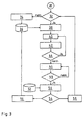
- a query 32 starts, which includes whether the next waypoint to be approached, according to the example the waypoint R 1 , is known. If the next waypoint R 1 is not known, a search 34 is carried out, the result of which is a determination 36 of the next waypoint. If the next waypoint R 1 is known or has been determined, the instantaneous distance (hereinafter also distance d) of the vehicle from the next waypoint R 1 is determined 38. Assuming in the example that the vehicle is at position point P 4 , the instantaneous distance is d P4 from waypoint R1. This instantaneous distance is temporarily stored in a step 40 as d min .
- position point P 5 is passed next.
- the distance (distance) to waypoint R 1 is determined again in a step 42.
- a query 44 then takes place as to whether the new distance d P5 is smaller than the distance d min buffered in step 40. If the new distance d P5 is smaller, it is temporarily stored as a new value d min .
- the query 44 is repeated for each of the position points until the distance d min to the waypoint R 1 can no longer be fallen below at the position point P 7 .
- This determination or monitoring of the approach of the vehicle to the waypoint R 1 can, according to a first aspect of the invention, be used to visually and / or acoustically output destination guidance information to the driver in good time, that is to say in good time before the waypoint R 1 is reached .
- the route guidance can be given - according to the assumed cheapest route - to drive straight on at waypoint R 1 .
- the vehicle successively passes the position points P 8 , P 9 , P 10 , P 11 , P 12 , P 13 .
- the waypoint R 1 is removed, for example when passing the position point P 8 , the instantaneous distance d from the way point R 1 becomes larger, since the minimum possible distance at the position point P 7 , which coincides with the way point R 1 , is given.
- the current distance d to the waypoint R 1, which is now increasing, is then determined in a step 46.
- the instantaneous distance d is compared with a distance threshold value e F. If the instantaneous distance d is smaller than the distance threshold value e F , when passing the next position point in each case - according to the example of position points P 9 , P 10 , P 11 - the current distance d to the waypoint R 1 is determined anew (step 46) and the query 48 is started again. It is assumed that the distance threshold value e F corresponds to the distance d from the position point P 12 and thus the auxiliary waypoint R 12 to the waypoint R 1 .
- a travel direction comparison is carried out in a next step 50. Since the mere increase in the distance from the waypoint R 1 is not yet a criterion for the direction of travel (the distance d up to the distance threshold value e F also increases when driving in the direction of the waypoint R 2 or the alternative waypoint A 2 ), the directional information from direction sensors for example GPS or gyrocompass, which determines the direction of travel of the vehicle.
- the waypoints R 0 , R 2 , A 1 and A 2 adjoining the waypoint R 1 are used from a buffer 52 and a query 54 ascertains which of the waypoints adjoining the waypoint R 1 has the smallest difference in direction.
- This waypoint according to the example the waypoint A 1 , is determined in a selection step 56 as the next waypoint (step 36), so that when the vehicle approaches the then new waypoint A 1, the method according to the invention for operating the navigation system 10 runs again.
- query 54 reveals that the next waypoint is not in the previously selected route corridor - which is defined by the input of destination point R 3 by the vehicle driver - either mass storage device 16 or, in the case of offboard systems, superordinate service center 22 are requested whether the next waypoint is known.
- the routine then restarts at query 32.
- the exemplary explanation makes it clear that information from a location system and information from a digital map - the digital map, for example, only having to contain the decision points of a route - can be linked to one another in such a way that acoustic and / or optical route guidance instructions can be output in a time-critical manner. Furthermore, after passing a decision point (according to example waypoint R 1 ), the next decision point can be determined. The next decision point does not have to be the one that is predefined by a cheapest route. In addition to issuing route guidance instructions, this information can also be used to ensure that knowledge of the direction of travel taken after a decision point is used to determine the correctness of the route actually traveled. Deviations from the specified cheapest route are possible. This knowledge can either be used to give the driver appropriate information or to determine a new cheapest route depending on the actual deviation from the cheapest route.
- the method according to the invention is particularly suitable for operation a navigation system in so-called offboard navigation systems, since here the cheapest route or partial route determined.
- a navigation system in so-called offboard navigation systems, since here the cheapest route or partial route determined.
- Navigation system 10 is transmitted.
- These digital cards or routes are characterized by the fact that they have very few Data information is described so that transmission capacity and thus transmission costs can be reduced.
- the reduced data information for example the decision points of the route and those at the respective decision points contain possible route guidance, out.
Landscapes
- Engineering & Computer Science (AREA)
- Radar, Positioning & Navigation (AREA)
- Remote Sensing (AREA)
- Physics & Mathematics (AREA)
- General Physics & Mathematics (AREA)
- Automation & Control Theory (AREA)
- Navigation (AREA)
- Instructional Devices (AREA)
- Traffic Control Systems (AREA)
Applications Claiming Priority (3)
| Application Number | Priority Date | Filing Date | Title |
|---|---|---|---|
| DE10117395A DE10117395A1 (de) | 2001-04-06 | 2001-04-06 | Verfahren zum Betrieb eines Navigationssystems für ein Fahrzeug, insbesondere ein Kraftfahrzeug und Navigationssystem |
| DE10117395 | 2001-04-06 | ||
| PCT/DE2002/000501 WO2002082404A1 (de) | 2001-04-06 | 2002-02-13 | Verfahren zum betrieb eines navigationssystems für ein fahrzeug |
Publications (2)
| Publication Number | Publication Date |
|---|---|
| EP1380021A1 EP1380021A1 (de) | 2004-01-14 |
| EP1380021B1 true EP1380021B1 (de) | 2004-09-01 |
Family
ID=7680768
Family Applications (1)
| Application Number | Title | Priority Date | Filing Date |
|---|---|---|---|
| EP02708235A Expired - Lifetime EP1380021B1 (de) | 2001-04-06 | 2002-02-13 | Verfahren zum betrieb eines navigationssystems fur ein fahrzeug |
Country Status (5)
| Country | Link |
|---|---|
| US (1) | US20040210387A1 (ja) |
| EP (1) | EP1380021B1 (ja) |
| JP (1) | JP2004527749A (ja) |
| DE (2) | DE10117395A1 (ja) |
| WO (1) | WO2002082404A1 (ja) |
Cited By (1)
| Publication number | Priority date | Publication date | Assignee | Title |
|---|---|---|---|---|
| DE102009028630A1 (de) | 2009-08-18 | 2011-02-24 | Robert Bosch Gmbh | Navigationssystem und ein Verfahren zur Positionsbestimmung eines Kraftfahrzeugs |
Families Citing this family (9)
| Publication number | Priority date | Publication date | Assignee | Title |
|---|---|---|---|---|
| US7474960B1 (en) | 2002-12-30 | 2009-01-06 | Mapquest, Inc. | Presenting a travel route |
| DE102005039283A1 (de) * | 2005-08-19 | 2007-02-22 | Robert Bosch Gmbh | Verfahren zum Betrieb eines Navigationssystems und Navigationssystem |
| CN101685024B (zh) * | 2008-09-27 | 2012-07-04 | 佛山市顺德区顺达电脑厂有限公司 | 导航系统及其路径规划方法 |
| CN102155954A (zh) * | 2010-02-11 | 2011-08-17 | 上海博泰悦臻电子设备制造有限公司 | 车载设备及其导航方法 |
| CN105300375B (zh) * | 2015-09-29 | 2018-04-20 | 塔米智能科技(北京)有限公司 | 一种基于单视觉的机器人室内定位和导航方法 |
| JP7115214B2 (ja) * | 2018-10-22 | 2022-08-09 | トヨタ自動車株式会社 | 車両用通知システム |
| JP7157876B2 (ja) * | 2019-05-08 | 2022-10-20 | 日立Astemo株式会社 | 車両位置検出装置、及び、車両位置検出用パラメータセット作成装置 |
| DE102022112167A1 (de) | 2022-05-16 | 2023-11-16 | Bayerische Motoren Werke Aktiengesellschaft | Verfahren zum Abfragen von prädizierten Routen von einem Backend-Server durch ein Fahrzeug, computerlesbares Medium, System, und Fahrzeug |
| DE102022003849A1 (de) | 2022-10-17 | 2022-12-29 | Mercedes-Benz Group AG | Verfahren zum Betrieb eines Navigationssystems |
Family Cites Families (3)
| Publication number | Priority date | Publication date | Assignee | Title |
|---|---|---|---|---|
| US4924402A (en) * | 1986-07-02 | 1990-05-08 | Pioneer Electronic Corporation | Method for identifying current position of vehicle |
| EP0380673A4 (en) * | 1988-08-11 | 1992-09-09 | Aisin Aw Co., Ltd. | Navigation system |
| JP3302445B2 (ja) * | 1993-06-18 | 2002-07-15 | パイオニア株式会社 | ナビゲーション装置 |
-
2001
- 2001-04-06 DE DE10117395A patent/DE10117395A1/de not_active Withdrawn
-
2002
- 2002-02-13 EP EP02708235A patent/EP1380021B1/de not_active Expired - Lifetime
- 2002-02-13 DE DE50200937T patent/DE50200937D1/de not_active Expired - Lifetime
- 2002-02-13 US US10/474,092 patent/US20040210387A1/en not_active Abandoned
- 2002-02-13 WO PCT/DE2002/000501 patent/WO2002082404A1/de active IP Right Grant
- 2002-02-13 JP JP2002580291A patent/JP2004527749A/ja active Pending
Cited By (1)
| Publication number | Priority date | Publication date | Assignee | Title |
|---|---|---|---|---|
| DE102009028630A1 (de) | 2009-08-18 | 2011-02-24 | Robert Bosch Gmbh | Navigationssystem und ein Verfahren zur Positionsbestimmung eines Kraftfahrzeugs |
Also Published As
| Publication number | Publication date |
|---|---|
| DE10117395A1 (de) | 2002-10-10 |
| US20040210387A1 (en) | 2004-10-21 |
| EP1380021A1 (de) | 2004-01-14 |
| JP2004527749A (ja) | 2004-09-09 |
| WO2002082404A1 (de) | 2002-10-17 |
| DE50200937D1 (de) | 2004-10-07 |
Similar Documents
| Publication | Publication Date | Title |
|---|---|---|
| DE69730463T2 (de) | Verfahren und Vorrichtung zum Eingeben von Routen in einem Navigationssystem | |
| DE69331485T2 (de) | Navigationssystem für Fahrzeuge | |
| DE69318489T2 (de) | Fahrzeugnavigationssystem | |
| DE69333933T2 (de) | Fahrzeugnavigationssystem | |
| EP0979387B1 (de) | Navigationsgerät und verfahren zur positionsbestimmung mittels koppelnavigation | |
| EP1485897B1 (de) | Verfahren und system zur automatischen fahrzeugführung | |
| DE4226230C2 (de) | Vorrichtung zur Navigation von Motorfahrzeugen | |
| DE102007033461A1 (de) | Navigationssystem | |
| EP0861482A2 (de) | Verfahren und zielführungseinheit zur sicheren zielführung eines fahrzeugs | |
| WO1995030881A1 (de) | Korrekturverfahren und navigationssystem für die koppelortung eines kraftfahrzeugs | |
| DE10052194A1 (de) | Navigationssystem mit einer Fahrtrouten-Ersetzungsfunktion | |
| DE102006027832A1 (de) | Fahrzeugnavigationssystem | |
| DE3719702A1 (de) | Verfahren und einrichtung zur navigation | |
| DE3751435T2 (de) | Vorrichtung zur Kursanzeige. | |
| EP1380021B1 (de) | Verfahren zum betrieb eines navigationssystems fur ein fahrzeug | |
| DE19725075A1 (de) | Einrichtung zur Bereitstellung von Informationen über die jeweils vorgegebene Höchstgeschwindigkeit in einem Kraftfahrzeug | |
| DE102004016745A1 (de) | Fahrzeugnavigationsvorrichtung | |
| WO2020259992A1 (de) | Angleichen von koordinatensystemen mehrerer karten basierend auf trajektorien | |
| DE19701370A1 (de) | Verfahren zur Erweiterung von abgespeicherten Datensätzen eines Straßennetzes | |
| EP1301755B1 (de) | Navigationsgerät und verfahren zur positionskorrektur | |
| DE102007057989B4 (de) | Vorrichtung zur Navigation | |
| WO1998013666A1 (de) | Verfahren und einrichtung zur zielführungsunterstützung eines fahrzeugführers | |
| DE19544382C2 (de) | Verfahren und Zielführungseinheit zur sicheren Zielführung eines Fahrzeugs | |
| WO2003004971A1 (de) | Verfahren zum betrieb eines navigationssystems für ein fahrzeug,insbesondere ein kraftfahrzeug, und navigationssystem | |
| EP3499271A1 (de) | Ermittlung einer position eines fahrzeugs |
Legal Events
| Date | Code | Title | Description |
|---|---|---|---|
| PUAI | Public reference made under article 153(3) epc to a published international application that has entered the european phase |
Free format text: ORIGINAL CODE: 0009012 |
|
| 17P | Request for examination filed |
Effective date: 20031106 |
|
| AK | Designated contracting states |
Kind code of ref document: A1 Designated state(s): AT BE CH CY DE DK ES FI FR GB GR IE IT LI LU MC NL PT SE TR |
|
| AX | Request for extension of the european patent |
Extension state: AL LT LV MK RO SI |
|
| GRAP | Despatch of communication of intention to grant a patent |
Free format text: ORIGINAL CODE: EPIDOSNIGR1 |
|
| RIN1 | Information on inventor provided before grant (corrected) |
Inventor name: SKWAREK, VOLKER Inventor name: FRIEDRICHS, ARNE Inventor name: DRAEGER, GERD |
|
| RIN1 | Information on inventor provided before grant (corrected) |
Inventor name: FRIEDRICHS, ARNE Inventor name: SKWAREK, VOLKER Inventor name: DRAEGER, GERD |
|
| GRAS | Grant fee paid |
Free format text: ORIGINAL CODE: EPIDOSNIGR3 |
|
| GRAA | (expected) grant |
Free format text: ORIGINAL CODE: 0009210 |
|
| AK | Designated contracting states |
Kind code of ref document: B1 Designated state(s): DE FR GB |
|
| REG | Reference to a national code |
Ref country code: GB Ref legal event code: FG4D Free format text: NOT ENGLISH |
|
| REG | Reference to a national code |
Ref country code: IE Ref legal event code: FG4D Free format text: GERMAN |
|
| REF | Corresponds to: |
Ref document number: 50200937 Country of ref document: DE Date of ref document: 20041007 Kind code of ref document: P |
|
| GBT | Gb: translation of ep patent filed (gb section 77(6)(a)/1977) |
Effective date: 20050124 |
|
| LTIE | Lt: invalidation of european patent or patent extension |
Effective date: 20040901 |
|
| REG | Reference to a national code |
Ref country code: IE Ref legal event code: FD4D |
|
| PLBE | No opposition filed within time limit |
Free format text: ORIGINAL CODE: 0009261 |
|
| STAA | Information on the status of an ep patent application or granted ep patent |
Free format text: STATUS: NO OPPOSITION FILED WITHIN TIME LIMIT |
|
| ET | Fr: translation filed | ||
| 26N | No opposition filed |
Effective date: 20050602 |
|
| REG | Reference to a national code |
Ref country code: GB Ref legal event code: 732E Free format text: REGISTERED BETWEEN 20140424 AND 20140430 |
|
| REG | Reference to a national code |
Ref country code: FR Ref legal event code: PLFP Year of fee payment: 15 |
|
| REG | Reference to a national code |
Ref country code: DE Ref legal event code: R081 Ref document number: 50200937 Country of ref document: DE Owner name: TOMTOM GLOBAL ASSETS B.V., NL Free format text: FORMER OWNER: ROBERT BOSCH GMBH, 70469 STUTTGART, DE |
|
| REG | Reference to a national code |
Ref country code: FR Ref legal event code: TP Owner name: TOMTOM GLOBAL ASSETS B.V., NL Effective date: 20160503 |
|
| REG | Reference to a national code |
Ref country code: FR Ref legal event code: PLFP Year of fee payment: 16 |
|
| REG | Reference to a national code |
Ref country code: FR Ref legal event code: PLFP Year of fee payment: 17 |
|
| PGFP | Annual fee paid to national office [announced via postgrant information from national office to epo] |
Ref country code: FR Payment date: 20210126 Year of fee payment: 20 |
|
| PGFP | Annual fee paid to national office [announced via postgrant information from national office to epo] |
Ref country code: GB Payment date: 20210203 Year of fee payment: 20 Ref country code: DE Payment date: 20210202 Year of fee payment: 20 |
|
| REG | Reference to a national code |
Ref country code: DE Ref legal event code: R071 Ref document number: 50200937 Country of ref document: DE |
|
| REG | Reference to a national code |
Ref country code: GB Ref legal event code: PE20 Expiry date: 20220212 |
|
| PG25 | Lapsed in a contracting state [announced via postgrant information from national office to epo] |
Ref country code: GB Free format text: LAPSE BECAUSE OF EXPIRATION OF PROTECTION Effective date: 20220212 |