EP1380021B1 - Method for operating a navigation system for a vehicle - Google Patents
Method for operating a navigation system for a vehicle Download PDFInfo
- Publication number
- EP1380021B1 EP1380021B1 EP02708235A EP02708235A EP1380021B1 EP 1380021 B1 EP1380021 B1 EP 1380021B1 EP 02708235 A EP02708235 A EP 02708235A EP 02708235 A EP02708235 A EP 02708235A EP 1380021 B1 EP1380021 B1 EP 1380021B1
- Authority
- EP
- European Patent Office
- Prior art keywords
- vehicle
- distance
- route
- decision point
- point
- Prior art date
- Legal status (The legal status is an assumption and is not a legal conclusion. Google has not performed a legal analysis and makes no representation as to the accuracy of the status listed.)
- Expired - Lifetime
Links
- 238000000034 method Methods 0.000 title claims description 25
- 238000012545 processing Methods 0.000 claims description 7
- 230000001133 acceleration Effects 0.000 claims 1
- 238000013459 approach Methods 0.000 description 4
- 230000005540 biological transmission Effects 0.000 description 4
- 238000010586 diagram Methods 0.000 description 3
- 230000000007 visual effect Effects 0.000 description 2
- 238000005259 measurement Methods 0.000 description 1
- 238000012544 monitoring process Methods 0.000 description 1
- 230000003287 optical effect Effects 0.000 description 1
- 238000012546 transfer Methods 0.000 description 1
Images


Classifications
-
- G—PHYSICS
- G08—SIGNALLING
- G08G—TRAFFIC CONTROL SYSTEMS
- G08G1/00—Traffic control systems for road vehicles
- G08G1/09—Arrangements for giving variable traffic instructions
- G08G1/0962—Arrangements for giving variable traffic instructions having an indicator mounted inside the vehicle, e.g. giving voice messages
- G08G1/0968—Systems involving transmission of navigation instructions to the vehicle
- G08G1/096805—Systems involving transmission of navigation instructions to the vehicle where the transmitted instructions are used to compute a route
- G08G1/096811—Systems involving transmission of navigation instructions to the vehicle where the transmitted instructions are used to compute a route where the route is computed offboard
-
- G—PHYSICS
- G01—MEASURING; TESTING
- G01C—MEASURING DISTANCES, LEVELS OR BEARINGS; SURVEYING; NAVIGATION; GYROSCOPIC INSTRUMENTS; PHOTOGRAMMETRY OR VIDEOGRAMMETRY
- G01C21/00—Navigation; Navigational instruments not provided for in groups G01C1/00 - G01C19/00
- G01C21/26—Navigation; Navigational instruments not provided for in groups G01C1/00 - G01C19/00 specially adapted for navigation in a road network
- G01C21/34—Route searching; Route guidance
-
- G—PHYSICS
- G08—SIGNALLING
- G08G—TRAFFIC CONTROL SYSTEMS
- G08G1/00—Traffic control systems for road vehicles
- G08G1/09—Arrangements for giving variable traffic instructions
- G08G1/0962—Arrangements for giving variable traffic instructions having an indicator mounted inside the vehicle, e.g. giving voice messages
- G08G1/0968—Systems involving transmission of navigation instructions to the vehicle
- G08G1/096805—Systems involving transmission of navigation instructions to the vehicle where the transmitted instructions are used to compute a route
- G08G1/096811—Systems involving transmission of navigation instructions to the vehicle where the transmitted instructions are used to compute a route where the route is computed offboard
- G08G1/096822—Systems involving transmission of navigation instructions to the vehicle where the transmitted instructions are used to compute a route where the route is computed offboard where the segments of the route are transmitted to the vehicle at different locations and times
-
- G—PHYSICS
- G08—SIGNALLING
- G08G—TRAFFIC CONTROL SYSTEMS
- G08G1/00—Traffic control systems for road vehicles
- G08G1/09—Arrangements for giving variable traffic instructions
- G08G1/0962—Arrangements for giving variable traffic instructions having an indicator mounted inside the vehicle, e.g. giving voice messages
- G08G1/0968—Systems involving transmission of navigation instructions to the vehicle
- G08G1/096855—Systems involving transmission of navigation instructions to the vehicle where the output is provided in a suitable form to the driver
- G08G1/096861—Systems involving transmission of navigation instructions to the vehicle where the output is provided in a suitable form to the driver where the immediate route instructions are output to the driver, e.g. arrow signs for next turn
-
- G—PHYSICS
- G08—SIGNALLING
- G08G—TRAFFIC CONTROL SYSTEMS
- G08G1/00—Traffic control systems for road vehicles
- G08G1/09—Arrangements for giving variable traffic instructions
- G08G1/0962—Arrangements for giving variable traffic instructions having an indicator mounted inside the vehicle, e.g. giving voice messages
- G08G1/0968—Systems involving transmission of navigation instructions to the vehicle
- G08G1/096855—Systems involving transmission of navigation instructions to the vehicle where the output is provided in a suitable form to the driver
- G08G1/096872—Systems involving transmission of navigation instructions to the vehicle where the output is provided in a suitable form to the driver where instructions are given per voice
Definitions
- the invention relates to a method for operating a navigation system for a vehicle, for a motor vehicle in which determined by a location system data on the geographic position and to an electronic data processing device with access transferred to a database and a digital road map and based on this data the location of the vehicle on the digital Road map is determined and the driver of the vehicle Acoustic and / or visual route guidance instructions are issued.
- a method for operating a navigation system for a vehicle for a motor vehicle in which determined by a location system data on the geographic position and to an electronic data processing device with access transferred to a database and a digital road map and based on this data the location of the vehicle on the digital Road map is determined and the driver of the vehicle Acoustic and / or visual route guidance instructions are issued.
- a method is known from EP-A-629 840 known.
- Navigation systems for vehicles especially motor vehicles, as well Methods for operating such navigation systems are known. These are used to determine the current geographic position of the Determine vehicle and depending on a predetermined, too relevant destination to calculate the cheapest route and give the driver instructions on the route.
- the known navigation systems require information for the Determination of the current location of the vehicle and the calculation the route are necessary. These include in particular Road courses, turning conditions and the like. These dates are stored in the form of a database, for example one CD-ROM, kept in the vehicle.
- the database includes this for example a so-called digital map, the waypoints and / or contains decision points of the possible routes.
- a location system which is the current geographical Determines the position of the vehicle.
- This is known, for example the satellite-based Global Positioning System (GPS).
- GPS Global Positioning System
- a The facility for electronic data processing processes the data from Positioning system delivered position data with those in the digital road map stored data and determines the current position of the Vehicle. According to the selected target point you can now through the facility for electronic data processing based on Waypoints and / or decision points on a selected one cheapest route to the driver visually and / or acoustically Route guidance information is given.
- map matching compare the information for operating a navigation system various sensors for determining the position of the vehicle (e.g. via GPS), the direction of travel of the vehicle (e.g. via gyrocompass) and a driving speed of the Vehicle (for example via speed sensors) with the Information of the saved digital map. Since the sensors in are usually afflicted with measurement errors, these are and direction information of the digital map are compared and corrected. The content of a digital one is therefore used to correct the sensors Map with the highest possible resolution (fine geometry or shape points) necessary.
- the invention has for its object a method for operation a navigation system for a vehicle, in particular a motor vehicle, and improve navigation system.
- the method according to the invention for operating a navigation system with the features mentioned in claim 1 offers the advantage that based on less information from a digital map and location information the vehicle's time-critical route guidance can be issued to a driver.
- a current distance of the vehicle from one first decision point of one to be driven by the vehicle Route is checked and if a minimum distance is exceeded of the vehicle after passing the first decision point next decision point is determined, is advantageously possible
- the method is based on Distance checks, especially for changes in a distance based on decision points, is a simple Processing of data possible, so that the navigation system as a whole can be operated with little effort.
- the received distance information or received information about changing a distance to decision points for checking compliance with a given cheapest Route can be used. This advantageously makes additional possible Output information to the driver that he the cheapest route to reach the destination specified by him has left. Furthermore, this advantageously makes it possible accordingly a route change made by the driver to determine a new cheapest route and this the other Based on route guidance.
- FIG. 1 schematically shows a navigation system designated overall by 10 for a motor vehicle.
- the navigation system 10 comprises a device 12 for electronic data processing, which in detail microprocessors, memory elements or not shown the like.
- the navigation system 10 further includes a location system 14, for example a global known per se Positioning system (GPS).
- the device 12 is a mass storage device 16, for example a CD-ROM, and / or a receiving device 18 assigned.
- the receiving device 18 communicates via a Transmission path 20 with a higher-level, stationary service center 22. Via the mass storage device 16 and / or the receiving device 18 can transmit a digital road map to the device 12 become.
- the navigation system 10 the mass storage device 16 and the receiving device 18 or only have the mass storage device 16 or the receiving device 18.
- the provision of digital road maps for the navigation system 10 is generally known, so this is within the scope of the description should not be discussed in more detail.
- the navigation system 10 further comprises a visual output device 24, for example a display or the like, and / or one acoustic output device 26, for example a loudspeaker or similar.
- Figure 2 shows a section of a route for a vehicle. It is assumed here that a vehicle wants to get from waypoint R 0 to its final destination (destination point), waypoint R 3 .
- the cheapest route here is the route via waypoints R 1 and R 2 to R 3 .
- This information is given to the navigation system 10 either via the mass storage device 16 or via the superordinate data system 22 and the receiving device 18.
- the navigation system 10 at the same time receives knowledge of further waypoints which are located on the cheapest route and which are possible as alternative waypoints A 1 and A 2 for reaching the planned final destination R 9 (route corridor).
- the waypoints R 1 , R 2 and A 1 and A 2 are each decision points at which, for example, a change of direction by turning is possible.
- Auxiliary waypoints are defined around each waypoint, of which the auxiliary waypoints R 11 , R 12 , R 13 and R 14 assigned to the waypoint R are shown here. These are not decision points.
- the position points P correspond to the current positions of the vehicle ascertained by the positioning system 14.
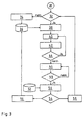
- a query 32 starts, which includes whether the next waypoint to be approached, according to the example the waypoint R 1 , is known. If the next waypoint R 1 is not known, a search 34 is carried out, the result of which is a determination 36 of the next waypoint. If the next waypoint R 1 is known or has been determined, the instantaneous distance (hereinafter also distance d) of the vehicle from the next waypoint R 1 is determined 38. Assuming in the example that the vehicle is at position point P 4 , the instantaneous distance is d P4 from waypoint R1. This instantaneous distance is temporarily stored in a step 40 as d min .
- position point P 5 is passed next.
- the distance (distance) to waypoint R 1 is determined again in a step 42.
- a query 44 then takes place as to whether the new distance d P5 is smaller than the distance d min buffered in step 40. If the new distance d P5 is smaller, it is temporarily stored as a new value d min .
- the query 44 is repeated for each of the position points until the distance d min to the waypoint R 1 can no longer be fallen below at the position point P 7 .
- This determination or monitoring of the approach of the vehicle to the waypoint R 1 can, according to a first aspect of the invention, be used to visually and / or acoustically output destination guidance information to the driver in good time, that is to say in good time before the waypoint R 1 is reached .
- the route guidance can be given - according to the assumed cheapest route - to drive straight on at waypoint R 1 .
- the vehicle successively passes the position points P 8 , P 9 , P 10 , P 11 , P 12 , P 13 .
- the waypoint R 1 is removed, for example when passing the position point P 8 , the instantaneous distance d from the way point R 1 becomes larger, since the minimum possible distance at the position point P 7 , which coincides with the way point R 1 , is given.
- the current distance d to the waypoint R 1, which is now increasing, is then determined in a step 46.
- the instantaneous distance d is compared with a distance threshold value e F. If the instantaneous distance d is smaller than the distance threshold value e F , when passing the next position point in each case - according to the example of position points P 9 , P 10 , P 11 - the current distance d to the waypoint R 1 is determined anew (step 46) and the query 48 is started again. It is assumed that the distance threshold value e F corresponds to the distance d from the position point P 12 and thus the auxiliary waypoint R 12 to the waypoint R 1 .
- a travel direction comparison is carried out in a next step 50. Since the mere increase in the distance from the waypoint R 1 is not yet a criterion for the direction of travel (the distance d up to the distance threshold value e F also increases when driving in the direction of the waypoint R 2 or the alternative waypoint A 2 ), the directional information from direction sensors for example GPS or gyrocompass, which determines the direction of travel of the vehicle.
- the waypoints R 0 , R 2 , A 1 and A 2 adjoining the waypoint R 1 are used from a buffer 52 and a query 54 ascertains which of the waypoints adjoining the waypoint R 1 has the smallest difference in direction.
- This waypoint according to the example the waypoint A 1 , is determined in a selection step 56 as the next waypoint (step 36), so that when the vehicle approaches the then new waypoint A 1, the method according to the invention for operating the navigation system 10 runs again.
- query 54 reveals that the next waypoint is not in the previously selected route corridor - which is defined by the input of destination point R 3 by the vehicle driver - either mass storage device 16 or, in the case of offboard systems, superordinate service center 22 are requested whether the next waypoint is known.
- the routine then restarts at query 32.
- the exemplary explanation makes it clear that information from a location system and information from a digital map - the digital map, for example, only having to contain the decision points of a route - can be linked to one another in such a way that acoustic and / or optical route guidance instructions can be output in a time-critical manner. Furthermore, after passing a decision point (according to example waypoint R 1 ), the next decision point can be determined. The next decision point does not have to be the one that is predefined by a cheapest route. In addition to issuing route guidance instructions, this information can also be used to ensure that knowledge of the direction of travel taken after a decision point is used to determine the correctness of the route actually traveled. Deviations from the specified cheapest route are possible. This knowledge can either be used to give the driver appropriate information or to determine a new cheapest route depending on the actual deviation from the cheapest route.
- the method according to the invention is particularly suitable for operation a navigation system in so-called offboard navigation systems, since here the cheapest route or partial route determined.
- a navigation system in so-called offboard navigation systems, since here the cheapest route or partial route determined.
- Navigation system 10 is transmitted.
- These digital cards or routes are characterized by the fact that they have very few Data information is described so that transmission capacity and thus transmission costs can be reduced.
- the reduced data information for example the decision points of the route and those at the respective decision points contain possible route guidance, out.
Description
Die Erfindung betrifft ein Verfahren zum Betrieb eines Navigationssystems für ein Fahrzeug, für ein Kraftfahrzeug, bei dem von einem Ortungssystem Daten zur geographischen Position ermittelt und an eine Einrichtung zur elektronischen Datenverarbeitung mit Zugriff auf eine Datenbank und eine digitale Straßenkarte übertragen werden und anhand dieser Daten der Standort des Fahrzeuges auf der digitalen Straßenkarte bestimmt wird und dem Fahrer des Fahrzeuges akustisch und/oder visuell Zielführungsanweisungen ausgegeben werden. Solch ein Verfahren ist aus der EP-A-629 840 bekannt.The invention relates to a method for operating a navigation system for a vehicle, for a motor vehicle in which determined by a location system data on the geographic position and to an electronic data processing device with access transferred to a database and a digital road map and based on this data the location of the vehicle on the digital Road map is determined and the driver of the vehicle Acoustic and / or visual route guidance instructions are issued. Such a method is known from EP-A-629 840 known.
Navigationssysteme für Fahrzeuge, insbesondere Kraftfahrzeuge, sowie Verfahren zum Betreiben derartiger Mavigationssysteme sind bekannt. Diese dienen dazu, die aktuelle geographische Position des Fahrzeuges zu bestimmen und in Abhängigkeit eines vorgebbaren, zu errelchenden Zielpunktes die günstigste Fahrtroute zu berechnen und dem Fahrer Anweisungen zur Fahrtroute zu geben. Navigation systems for vehicles, especially motor vehicles, as well Methods for operating such navigation systems are known. These are used to determine the current geographic position of the Determine vehicle and depending on a predetermined, too relevant destination to calculate the cheapest route and give the driver instructions on the route.
Die bekannten Navigationssysteme benötigen Informationen, die für die Bestimmung des aktuellen Standortes des Fahrzeuges und die Berechnung der Fahrtroute notwendig sind. Hierzu gehören insbesondere Straßenverläufe, Abbiegebedingungen und dergleichen. Diese Daten werden in Form einer Datenbasis auf Speichern, beispielsweise einer CD-ROM, im Fahrzeug vorgehalten. Die Datenbasis umfasst hierzu beispielsweise eine so genannte digitale Karte, die Wegepunkte und/oder Entscheidungspunkte der möglichen Routen enthält.The known navigation systems require information for the Determination of the current location of the vehicle and the calculation the route are necessary. These include in particular Road courses, turning conditions and the like. These dates are stored in the form of a database, for example one CD-ROM, kept in the vehicle. The database includes this for example a so-called digital map, the waypoints and / or contains decision points of the possible routes.
Ferner ist ein Ortungssystem notwendig, das die aktuelle geographische Position des Fahrzeuges feststellt. Bekannt ist hierzu beispielsweise das satellitengestützte Global Positioning System (GPS). Eine Einrichtung zur elektronischen Datenverarbeitung verarbeitet die vom Ortungssystem gelieferten Positionsdaten mit den in der digitalen Straßenkarte gespeicherten Daten und bestimmt die aktuelle Position des Fahrzeuges. Entsprechend dem gewählten Zieipunkt kann nunmehr durch die Einrichtung zur elektronischen Datenverarbeitung anhand von Wegepunkten und/oder Entscheidungspunkten auf einer ausgewählten günstigsten Fahrtroute dem Fahrer visuell und/oder akustisch eine Zielführungsinformation gegeben werden.Furthermore, a location system is necessary, which is the current geographical Determines the position of the vehicle. This is known, for example the satellite-based Global Positioning System (GPS). A The facility for electronic data processing processes the data from Positioning system delivered position data with those in the digital road map stored data and determines the current position of the Vehicle. According to the selected target point you can now through the facility for electronic data processing based on Waypoints and / or decision points on a selected one cheapest route to the driver visually and / or acoustically Route guidance information is given.
Diese als so genannte "Map-Matching"-Verfahren bekannten Verfahren zum Betrieb eines Navigationssystems vergleichen die informationen verschiedener Sensoren zur Bestimmung der Position des Fahrzeuges (beispielsweise über GPS), der Fahrtrichtung des Fahrzeuges (beispielsweise über Kreiselkompass) und einer Fahrgeschwindigkeit des Fahrzeuges (beispielsweise über Geschwindigkeitssensoren) mit den Informationen der abgespeicherten digitalen Karte. Da die Sensoren in der Regel mit Messfehlern behaftet sind, werden diese mit Hilfe der Positions- und Richtungsinformationen der digitalen Karte verglichen und korrigiert. Zur Korrektur der Sensoren ist daher der Inhalt einer digitalen Karte möglichst hoher Auflösung (Feingeometrie oder Shape-Points) notwendig.These methods, known as "map matching" methods compare the information for operating a navigation system various sensors for determining the position of the vehicle (e.g. via GPS), the direction of travel of the vehicle (e.g. via gyrocompass) and a driving speed of the Vehicle (for example via speed sensors) with the Information of the saved digital map. Since the sensors in are usually afflicted with measurement errors, these are and direction information of the digital map are compared and corrected. The content of a digital one is therefore used to correct the sensors Map with the highest possible resolution (fine geometry or shape points) necessary.
Werden jedoch beispielsweise digitale Karten eingesetzt, in denen diese Feingeometrie-Informationen nicht oder nur zum Teil vorhanden sind, können die bekannten Verfahren zum Betreiben eines Navigationssystems nicht eingesetzt werden. Digitale Karten ohne Feingeometrie-Informationen werden bei so genannten Offboard-Navigationssystemen eingesetzt, bei denen die entsprechenden informationen von einer Dienstezentrale über eine Übertragungsstrecke den Fahrzeugen übertragen werden. Da hier nur begrenzte Übertragungsraten zur Verfügung stehen, werden die Daten auf ein notwendiges Minimum reduziert. Bekannt ist, bei diesen Offboard-Navigationssystemen den Fahrzeugen die Entscheldungspunkte einer günstigsten Fahrtroute zu übermitteln.However, digital cards are used, for example, in which these Fine geometry information is not or only partially available are the known methods for operating a navigation system not be used. Digital maps without fine geometry information are used in so-called offboard navigation systems used where the relevant information from a service center via a transmission link Vehicles are transmitted. There are only limited transfer rates here are available, the data is kept to a minimum reduced. It is known in these offboard navigation systems the vehicles the points of deregistration of a cheapest route to transmit.
Der Erfindung liegt die Aufgabe zugrunde, ein Verfahren zum Betrieb eines Navigationssystems für ein Fahrzeug, insbesondere ein Kraftfahrzeug, und Navigationssystem zu verbessern.The invention has for its object a method for operation a navigation system for a vehicle, in particular a motor vehicle, and improve navigation system.
Diese Aufgabe wird durch die in den Ansprüchen 1 und 10 angegeben
Maßnahmen bzw. Merkmalen gelöst. This object is indicated by that in
Das erfindungsgemäße Verfahren zum Betrieb eines Naviationssystems mit den im Anspruch 1 genannten Merkmalen bietet den Vorteil, dass auf Basis weniger Informationen einer digitalen Karte und Positionsinformationen des Fahrzeuges zeitkritische Zielführungsanweisungen an einen Fahrzeugführer ausgegeben werden können. Dadurch, dass permanent ein momentaner Abstand des Fahrzeuges von einem ersten Entscheidungspunkt einer durch das Fahrzeug zu befahrenden Route Überprüft wird und bei Überschreiten eines Mindestabstandes des Fahrzeuges nach Passieren des ersten Entscheidungspunktes ein nächster Entscheidungspunkt festgelegt wird, wird vorteilhaft möglich, Sensorinformationen eines Ortungssystems mit den Informationen der digitalen Karte, das heißt mit den Entscheidungspunkten der digitalen Karte, derart miteinander zu verknüpfen, dass neben einer exakten Zielführungsanweisung gleichzeitig eine Überprüfung der Fahrtroute möglich ist. Insbesondere dadurch, dass das Verfahren auf Basis von Abstandsüberprüfungen, insbesondere auf Änderungen eines Abstandes zu Entscheidungspunkten, basiert, wird in einfacher Weise eine Verarbeitung der Daten möglich, so dass das Navigationssystem insgesamt mit geringem Aufwand betrieben werden kann.The method according to the invention for operating a navigation system with the features mentioned in claim 1 offers the advantage that based on less information from a digital map and location information the vehicle's time-critical route guidance can be issued to a driver. Thereby, that there is always a current distance of the vehicle from one first decision point of one to be driven by the vehicle Route is checked and if a minimum distance is exceeded of the vehicle after passing the first decision point next decision point is determined, is advantageously possible Sensor information of a location system with the information from digital map, that is, with the decision points of the digital Map to be linked together in such a way that in addition to an exact Route guidance and a check of the route is possible. In particular in that the method is based on Distance checks, especially for changes in a distance based on decision points, is a simple Processing of data possible, so that the navigation system as a whole can be operated with little effort.
In bevorzugter Ausgestaltung der Erfindung ist vorgesehen, dass die erhaltenen Abstandsinformationen beziehungsweise erhaltenen Informationen über die Änderung eines Abstandes zu Entscheidungspunkten für eine Überprüfung der Einhaltung einer vorgegebenen günstigsten Fahrtroute genutzt werden. Hierdurch wird vorteilhaft möglich, zusätzliche Informationen an den Fahrzeugführer auszugeben, dass er die günstigste Route zum Erreichen des von ihm vorgegebenen Zielpunktes verlassen hat. Ferner wird hierdurch vorteilhaft möglich, entsprechend einer vom Fahrzeugführer vorgenommenen Routenänderung eine neue günstigste Fahrtroute zu ermitteln und diese den weiteren Zielführungsanweisungen zugrunde zu legen.In a preferred embodiment of the invention it is provided that the received distance information or received information about changing a distance to decision points for checking compliance with a given cheapest Route can be used. This advantageously makes additional possible Output information to the driver that he the cheapest route to reach the destination specified by him has left. Furthermore, this advantageously makes it possible accordingly a route change made by the driver to determine a new cheapest route and this the other Based on route guidance.
Das erfindungsgemäße Navigationssystem mit den im Anspruch 8 genannten Merkmalen bietet den Vorteil, dass dieses einen einfachen Aufbau besitzt und dennoch in der Lage ist, zeitkritische Zielführungsanweisungen auszugeben.The navigation system according to the invention with those mentioned in claim 8 Features offers the advantage that this is a simple one Has structure and is still able to provide time-critical route guidance issue.
Weitere bevorzugte Ausgestaltungen der Erfindung ergeben sich aus den übrigen in den Unteransprüchen genannten Merkmalen.Further preferred refinements of the invention result from the other features mentioned in the subclaims.
Die Erfindung wird nachfolgend in einem Ausführungsbeispiel anhand der zugehörigen Zeichnungen näher erläutert. Es zeigen:
- Figur 1
- ein Blockschaltbild des erfindungsgemäßen Navigationssystems;
- Figur 2
- den Ausschnitt aus einer Fahrtroute und
- Figur 3
- ein Blockschaltbild des Verfahrens zum Betreiben eines Navigationssystems.
- Figure 1
- a block diagram of the navigation system according to the invention;
- Figure 2
- the excerpt from a route and
- Figure 3
- a block diagram of the method for operating a navigation system.
Figur 1 zeigt schematisch ein insgesamt mit 10 bezeichnetes Navigationssystem
für ein Kraftfahrzeug. Das Navigationssystem 10 umfasst
eine Einrichtung 12 zur elektronischen Datenverarbeitung, die im Einzeinen
nicht dargestellte Mikroprozessoren, Speicherelemente oder
dergleichen aufweisen kann. Ferner umfasst das Navigationssystem 10
ein Ortungssystem 14, beispielsweise ein an sich bekanntes Global
Positioning System (GPS). Der Einrichtung 12 ist ein Massenspeicher
16, beispielsweise eine CD-ROM, und/oder eine Empfangseinrichtung
18 zugeordnet. Die Empfangseinrichtung 18 kommuniziert über eine
Übertragungsstrecke 20 mit einer übergeordneten, stationären Dienstezentrale
22. Über den Massenspeicher 16 und/oder die Empfangseinrichtung
18 kann der Einrichtung 12 eine digitale Straßenkarte übermittelt
werden. Je nach Ausführungsform kann das Navigationssystem
10 den Massenspeicher 16 und die Empfangseinrichtung 18 oder lediglich
den Massenspeicher 16 oder die Empfangseinrichtung 18 aufweisen.
Die Bereitstellung digitaler Straßenkarten für das Navigationssystem
10 ist allgemein bekannt, so dass hierauf im Rahmen der Beschreibung
nicht näher eingegangen werden soll.FIG. 1 schematically shows a navigation system designated overall by 10
for a motor vehicle. The
Das Navigationssystem 10 umfasst ferner eine visuelle Ausgabeeinrichtung
24, beispielsweise ein Display oder dergleichen, und/oder eine
akustische Ausgabeeinrichtung 26, beispielsweise ein Lautsprecher
oder dergleichen.The
Das erfindungsgemäße Verfahren zum Betreiben des Navigationssystems
10 wird nachfolgend anhand der Figuren 2 und 3 verdeutlicht. The method according to the invention for operating the
Figur 2 zeigt den Ausschnitt aus einer Route für ein Fahrzeug. Hierbei
sei angenommen, ein Fahrzeug möchte vom Wegpunkt R0 zu seinem
Endziel (Zielpunkt), dem Wegpunkt R3, gelangen. Hierbei ergibt sich als
günstigste Fahrtroute die Route über die Wegpunkte R1 und R2 zu R3.
Diese Informationen werden dem Navigationssystem 10 entweder über
den Massenspeicher 16 oder über das übergeordnete Datensystem 22
und die Empfangseinrichtung 18 vorgegeben. Das Navigationssystem
10 erhält gleichzeitig Kenntnis von an der günstigsten Route anliegenden
weiteren Wegpunkten, die als Ausweichwegpunkte A1 und A2 zum
Erreichen des geplanten Endzieles R9 möglich sind (Routenkorridor).
Die Wegpunkte R1, R2 sowie A1 und A2 sind jeweils Entscheidungspunkte,
an denen beispielsweise eine Fahrtrichtungsänderung durch
Abbiegen möglich ist. Um jeden Wegpunkt sind Hilfswegpunkte definiert,
von denen hier die dem Wegpunkt R zugeordneten Hilfswegpunkte
R11, R12, R13 und R14 dargestellt sind. Diese sind keine Entscheidungspunkte.Figure 2 shows a section of a route for a vehicle. It is assumed here that a vehicle wants to get from waypoint R 0 to its final destination (destination point), waypoint R 3 . The cheapest route here is the route via waypoints R 1 and R 2 to R 3 . This information is given to the
Es wird nunmehr angenommen, das Fahrzeug nähert sich vom Wegpunkt
R0 kommend dem Wegpunkt R1 an. Hierbei passiert das Fahrzeug
die Positionspunkte P1, P2, P3, P4, P5, P6 und P7. Die Positionspunkte
P entsprechen den vom Ortungssystem 14 festgestellten momentanen
Positionen des Fahrzeuges.It is now assumed that the vehicle approaches from coming waypoint R 0 R 1 at the waypoint. Here, the vehicle passes the position points P 1 , P 2 , P 3 , P 4 , P 5 , P 6 and P 7 . The position points P correspond to the current positions of the vehicle ascertained by the
Während der Annäherung des Fahrzeuges an den Wegpunkt R1 läuft
das in dem Blockschaltbild in Figur 3 dargestellte Verfahren ab. Ausgehend
von einem Start 30 an, startet eine Abfrage 32, die beinhaltet, ob
der nächste anzufahrende Wegpunkt, gemäß dem Beispiel der Wegpunkt
R1, bekannt ist. Ist der nächste Wegpunkt R1 nicht bekannt, erfolgt
eine Suche 34, in deren Ergebnis eine Festlegung 36 des nächsten
Wegpunktes erfolgt. Ist der nächste Wegpunkt R1 bekannt beziehungsweise
ist dieser festgelegt, erfolgt eine Ermittlung 38 des momentanen
Abstandes (nachfolgend auch Distanz d) des Fahrzeuges
zum nächsten Wegpunkt R1. Im Beispiel angenommen, das Fahrzeug
befindet sich an dem Positionspunkt P4, beträgt der momentane Abstand
dP4 zum Wegpunkt R1. Dieser momentane Abstand wird in einem
Schritt 40 als dmin zwischengespeichert. Durch weitere Annäherung des
Fahrzeuges an den Wegpunkt R1 wird als nächstes der Positionspunkt
P5 passiert. Am Positionspunkt P5 wird der Abstand (Distanz) zum
Wegpunkt R1 in einem Schritt 42 erneut ermittelt. Anschließend erfolgt
eine Abfrage 44, ob der neue Abstand dP5 kleiner ist als der im Schritt
40 zwischengespeicherte Abstand dmin. Ist der neue Abstand dP5 kleiner,
wird dieser als neuer Wert dmin zwischengespeichert. Während der
Annäherung des Fahrzeuges an den Wegpunkt R1 wird zu jedem der
Positionspunkte die Abfrage 44 wiederholt, bis beim Positionspunkt P7
der Abstand dmin zum Wegpunkt R1 nicht mehr unterschritten werden
kann.While the vehicle is approaching the waypoint R 1 , the method shown in the block diagram in FIG. 3 runs. Starting from a
Diese Ermittlung beziehungsweise Überwachung der Annäherung des Fahrzeuges an den Wegpunkt R1 kann gemäß einem ersten Aspekt der Erfindung dazu genutzt werden, um rechtzeitig, das heißt rechtzeitig vor Erreichen des Wegpunktes R1, eine Zielführuhgsinformation an den Fahrer visuell und/oder akustisch auszugeben. So kann beispielsweise zu den Positionspunkten P5 und/oder P6 und/oder P7 die Zielführungsanweisung - gemäß der angenommenen günstigsten Route - erfolgen, am Wegpunkt R1 geradeaus zu fahren. This determination or monitoring of the approach of the vehicle to the waypoint R 1 can, according to a first aspect of the invention, be used to visually and / or acoustically output destination guidance information to the driver in good time, that is to say in good time before the waypoint R 1 is reached . For example, for the position points P 5 and / or P 6 and / or P 7, the route guidance can be given - according to the assumed cheapest route - to drive straight on at waypoint R 1 .
Folgt der Fahrzeugführer dieser Zielführungsanweisung nicht und biegt
gemäß dem dargestellten Beispiel in Richtung des Ausweichwegpunktes
A1 ab, passiert das Fahrzeug aufeinander folgend die Positionspunkte
P8, P9, P10, P11, P12, P13. Gemäß der Abfrage 44 wird zu jedem
Positionspunkt ermittelt, ob der momentane Abstand d zum Wegpunkt
R1 kleiner oder größer wird als der zuvor zwischengespeicherte Abstand
dmin. Bei Entfernen vom Wegpunkt R1, beispielsweise beim Passieren
des Positionspunktes P8, wird der momentane Abstand d zum
Wegpunkt R1 größer, da der minimale mögliche Abstand im Positionspunkt
P7, der mit dem Wegpunkt R1 zusammenfällt, gegeben ist. Hierauf
wird in einem Schritt 46 der momentane - nun größer werdende -
Abstand d zum Wegpunkt R1 ermittelt. In einer sich anschließenden
Abfrage 48 wird der momentane Abstand d mit einem Entfernungsschwellwert
eF verglichen, ist der momentane Abstand d kleiner als der
Entfernungsschwellwert eF, wird beim Passieren des jeweils nächsten
Positionspunktes - gemäß dem Beispiel der Positionspunkte P9, P10,
P11 - der momentane Abstand d zum Wegpunkt R1 jeweils neu ermittelt
(Schritt 46) und jeweils erneut die Abfrage 48 gestartet. Es sei angenommen,
der Entfernungsschwellwert eF entspricht dem Abstand d des
Positionspunktes P12 und somit dem Hilfswegpunkt R12 zum Wegpunkt
R1.If the driver does not follow this route guidance and turns according to the example shown in the direction of the alternative waypoint A 1 , the vehicle successively passes the position points P 8 , P 9 , P 10 , P 11 , P 12 , P 13 . According to the
Wird der Entfernungsschwellwert eF erreicht, beispielsweise bei dem
Positionspunkt P12, wird in einem nächsten Schritt 50 ein Fahrtrichtungsabgleich
durchgeführt. Da die bloße Abstandsvergrößerung vom
Wegpunkt R1 noch kein Kriterium für die Fahrtrichtung ist (der Abstand
d bis zum Entfernungsschwellwert eF vergrößert sich auch bei angenommener
Fahrt in Richtung des Wegpunktes R2 beziehungsweise des
Ausweichwegpunktes A2), wird mittels der Richtungsinformationen von
Richtungssensoren, beispielsweise GPS oder Kreiselkompass, die
Fahrtrichtung des Fahrzeuges ermittelt. Hierbei werden aus einem Zwischenspeicher
52 die an den Wegpunkt R1 angrenzenden Wegpunkte
R0, R2, A1 und A2 herangezogen und über eine Abfrage 54 festgestellt,
zu welchen der an den Wegpunkt R1 angrenzenden Wegpunkte die
kleinste Richtungsdifferenz besteht. Dieser Wegpunkt, gemäß dem Beispiel
der Wegpunkt A1, wird in einem Auswahlschritt 56 als nächster
Wegpunkt bestimmt (Schritt 36), so dass bei Annäherung des Fahrzeuges
an den dann neuen Wegpunkt A1 das erfindungsgemäße Verfahren
zum Betrieb des Navigationssystems 10 erneut abläuft.If the distance threshold value e F is reached, for example at the position point P 12 , a travel direction comparison is carried out in a
Ergibt die Abfrage 54, dass der nächste Wegpunkt nicht in dem zuvor
ausgewählten Routenkorridor liegt - der sich durch die Eingabe des
Zielpunktes R3 durch den Fahrzeugführer definiert - wird in einem
Schritt 58 entweder der Massenspeicher 16 oder bei Offboard-Systemen
die übergeordnete Dienstezentrale 22 angefragt, ob der
nächste Wegpunkt bekannt ist. Die Routine startet dann neu bei der
Abfrage 32.If
Anhand der beispielhaften Erläuterung wird deutlich, dass durch lnformationen eines Ortungssystems und Informationen einer digitalen Karte - wobei die digitale Karte beispielsweise nur die Entscheidungspunkte einer Route enthalten muss - diese so miteinander verknüpft sein können, dass akustische und/oder optische Zielführungsanweisungen zeitkritisch ausgegeben werden können. Ferner kann nach Passieren eines Entscheidungspunktes (gemäß Beispiel Wegpunkt R1) der nächste Entscheidungspunkt bestimmt werden. Hierbei muss der nächste Entscheidungspunkt nicht derjenige sein, der durch eine günstigste Routenführung vorgegeben ist. Diese Informationen können neben der Ausgabe von Zielführungsanweisungen auch dazu genutzt werden, dass die Kenntnis über die eingeschlagene Fahrtrichtung nach einem Entscheidungspunkt zur Ermittlung der Richtigkeit der tatsächlich gefahrenen Route dient. Es sind also Abweichungen von der vorgegeben günstigsten Fahrtroute möglich. Diese Kenntnis kann entweder dazu genutzt werden, dem Fahrzeugführer entsprechende Informationen zu geben oder in Abhängigkeit der Ist-Abweichung von der günstigsten Fahrtroute eine neue günstigste Fahrtroute zu bestimmen.The exemplary explanation makes it clear that information from a location system and information from a digital map - the digital map, for example, only having to contain the decision points of a route - can be linked to one another in such a way that acoustic and / or optical route guidance instructions can be output in a time-critical manner. Furthermore, after passing a decision point (according to example waypoint R 1 ), the next decision point can be determined. The next decision point does not have to be the one that is predefined by a cheapest route. In addition to issuing route guidance instructions, this information can also be used to ensure that knowledge of the direction of travel taken after a decision point is used to determine the correctness of the route actually traveled. Deviations from the specified cheapest route are possible. This knowledge can either be used to give the driver appropriate information or to determine a new cheapest route depending on the actual deviation from the cheapest route.
Besonders geeignet ist das erfindungsgemaße Verfahren zum Betrieb
eines Navigationssystems in so genannten Offboard-Navigationssystemen,
da hier die ermittelte günstigste Route oder Teilroute.
In einer Dienstezentrale erstellt und zum Fahrzeug beziehungsweise
Navigationssystem 10 übertragen wird. Diese digitalen Karten
oder Routen zeichnen sich dadurch aus, dass sie mit sehr wenigen
Dateninformationen beschrieben werden, so dass Übertragungskapazitäten
und somit Übertragungskosten reduziert werden können. Letztendlich
reichen die reduzierten Dateninformationen, die beispielsweise
die Entscheidungspunkte der Route und die an den jeweiligen Entscheidungspunkten
möglichen Zielführungsanweisungen enthalten,
aus.The method according to the invention is particularly suitable for operation
a navigation system in so-called offboard navigation systems,
since here the cheapest route or partial route determined.
Created in a service center and for the vehicle respectively
Claims (10)
- Method for operating a navigation system (10) for a vehicle, in particular for a motor vehicle, in which data relating to the geographic position of the vehicle is determined by a locating system (14) and transmitted to a device (12) for electronic data processing with access to a database (16, 18) and a digital roadmap, and this data is used to determine the location of the vehicle along the digital road map, and the driver of the vehicle is issued with routing instructions acoustically and/or visually, characterized in that an instantaneous distance (d) between the vehicle and a first decision point (R1) of the route which is to be travelled along by the vehicle is continuously checked and when a minimum distance (dmin) of the vehicle is exceeded after the decision point (R1). is passed, the subsequent decision point (A1) is defined.
- Method according to Claim 1, characterized in that the minimum distance (dmin) to be exceeded is defined by a distance threshold value (eF).
- Method according to one of the preceding claims, characterized in that the distance threshold value (eF) is predefined by auxiliary route points (R12) which are defined about a decision point (R1).
- Method according to one of the preceding claims, characterized in that a travel direction reconciliation is carried out when the distance threshold value (eF) is reached.
- Method according to one of the preceding claims, characterized in that a distance threshold value (eF) can vary by the vehicle speed or other vehicle state variables (for example acceleration).
- Method according to Claim 4 or 5, characterized in that a smallest directional difference is determined between the aimed-at position point representing the distance threshold value (eF) and the route points (R0, R2, A1, A2) which are adjacent to the decision point (R1).
- Method according to Claim 5 or 6, characterized in that the route point which has the smallest directional difference is defined as the next decision point (A1).
- Method according to one of the preceding claims, characterized in that the route point which is at the smallest distance from the vehicle is defined as the next decision point.
- Method according to one of the preceding claims, characterized in that, when a predefinable minimum distance (dmin) from the next decision point (R1) is reached, the routing instruction is issued.
- Navigation system (10) for a vehicle, in particular a motor vehicle, having a locating system (14), a device (12) for electronic data processing, a database (16, 18) which has a digital roadmap, and at least one output device (24, 26) for outputting routing instructions, characterized by means for determining an instantaneous distance from a decision point (R1) of a route, by means for comparing the instantaneous distance with a minimum distance (dmin) and means for defining a new decision point (A1) of the route when the minimum distance (dmin) is exceeded.
Applications Claiming Priority (3)
| Application Number | Priority Date | Filing Date | Title |
|---|---|---|---|
| DE10117395A DE10117395A1 (en) | 2001-04-06 | 2001-04-06 | Method for operating a navigation system for a vehicle, in particular a motor vehicle and navigation system |
| DE10117395 | 2001-04-06 | ||
| PCT/DE2002/000501 WO2002082404A1 (en) | 2001-04-06 | 2002-02-13 | Method for operating a navigation system for a vehicle |
Publications (2)
| Publication Number | Publication Date |
|---|---|
| EP1380021A1 EP1380021A1 (en) | 2004-01-14 |
| EP1380021B1 true EP1380021B1 (en) | 2004-09-01 |
Family
ID=7680768
Family Applications (1)
| Application Number | Title | Priority Date | Filing Date |
|---|---|---|---|
| EP02708235A Expired - Lifetime EP1380021B1 (en) | 2001-04-06 | 2002-02-13 | Method for operating a navigation system for a vehicle |
Country Status (5)
| Country | Link |
|---|---|
| US (1) | US20040210387A1 (en) |
| EP (1) | EP1380021B1 (en) |
| JP (1) | JP2004527749A (en) |
| DE (2) | DE10117395A1 (en) |
| WO (1) | WO2002082404A1 (en) |
Cited By (1)
| Publication number | Priority date | Publication date | Assignee | Title |
|---|---|---|---|---|
| DE102009028630A1 (en) | 2009-08-18 | 2011-02-24 | Robert Bosch Gmbh | Navigation system for position determination of motor vehicle, has position determining device and evaluation device which is connected with detection device and position determination device |
Families Citing this family (9)
| Publication number | Priority date | Publication date | Assignee | Title |
|---|---|---|---|---|
| US7474960B1 (en) | 2002-12-30 | 2009-01-06 | Mapquest, Inc. | Presenting a travel route |
| DE102005039283A1 (en) * | 2005-08-19 | 2007-02-22 | Robert Bosch Gmbh | Method for operating a navigation system and navigation system |
| CN101685024B (en) * | 2008-09-27 | 2012-07-04 | 佛山市顺德区顺达电脑厂有限公司 | Navigation system and path planning method and machine-readable medium thereof |
| CN102155954A (en) * | 2010-02-11 | 2011-08-17 | 上海博泰悦臻电子设备制造有限公司 | Vehicular equipment and navigation method thereof |
| CN105300375B (en) * | 2015-09-29 | 2018-04-20 | 塔米智能科技(北京)有限公司 | A kind of robot indoor positioning and air navigation aid based on single vision |
| JP7115214B2 (en) * | 2018-10-22 | 2022-08-09 | トヨタ自動車株式会社 | Vehicle notification system |
| DE112020001543T5 (en) * | 2019-05-08 | 2022-01-20 | Hitachi Astemo, Ltd. | Vehicle position detection device and parameter set generation device for detecting the vehicle position |
| DE102022112167A1 (en) | 2022-05-16 | 2023-11-16 | Bayerische Motoren Werke Aktiengesellschaft | Method for querying predicted routes from a backend server by a vehicle, computer-readable medium, system, and vehicle |
| DE102022003849A1 (en) | 2022-10-17 | 2022-12-29 | Mercedes-Benz Group AG | Method for operating a navigation system |
Family Cites Families (3)
| Publication number | Priority date | Publication date | Assignee | Title |
|---|---|---|---|---|
| US4924402A (en) * | 1986-07-02 | 1990-05-08 | Pioneer Electronic Corporation | Method for identifying current position of vehicle |
| WO1990001679A1 (en) * | 1988-08-11 | 1990-02-22 | Aisin Aw Co., Ltd. | Navigation system |
| JP3302445B2 (en) * | 1993-06-18 | 2002-07-15 | パイオニア株式会社 | Navigation device |
-
2001
- 2001-04-06 DE DE10117395A patent/DE10117395A1/en not_active Withdrawn
-
2002
- 2002-02-13 WO PCT/DE2002/000501 patent/WO2002082404A1/en active IP Right Grant
- 2002-02-13 EP EP02708235A patent/EP1380021B1/en not_active Expired - Lifetime
- 2002-02-13 DE DE50200937T patent/DE50200937D1/en not_active Expired - Lifetime
- 2002-02-13 JP JP2002580291A patent/JP2004527749A/en active Pending
- 2002-02-13 US US10/474,092 patent/US20040210387A1/en not_active Abandoned
Cited By (1)
| Publication number | Priority date | Publication date | Assignee | Title |
|---|---|---|---|---|
| DE102009028630A1 (en) | 2009-08-18 | 2011-02-24 | Robert Bosch Gmbh | Navigation system for position determination of motor vehicle, has position determining device and evaluation device which is connected with detection device and position determination device |
Also Published As
| Publication number | Publication date |
|---|---|
| DE50200937D1 (en) | 2004-10-07 |
| JP2004527749A (en) | 2004-09-09 |
| EP1380021A1 (en) | 2004-01-14 |
| US20040210387A1 (en) | 2004-10-21 |
| WO2002082404A1 (en) | 2002-10-17 |
| DE10117395A1 (en) | 2002-10-10 |
Similar Documents
| Publication | Publication Date | Title |
|---|---|---|
| DE69730463T2 (en) | Method and device for entering routes in a navigation system | |
| DE69333933T2 (en) | Car navigation system | |
| EP0979387B1 (en) | Navigation device and method for position determination by means of coupled navigation | |
| EP1485897B1 (en) | Automatic vehicle guidance method and system | |
| DE4226230C2 (en) | Device for navigating motor vehicles | |
| EP3577420B1 (en) | Method and device for updating a digital map | |
| DE102007033461A1 (en) | navigation system | |
| WO1997018544A2 (en) | Process and guidance system for ensuring reliable guidance of a vehicle | |
| WO1995030881A1 (en) | Correction process and navigation system for the compound location of a motor vehicle | |
| DE10052194A1 (en) | Navigation apparatus for vehicles, uses route obtained after substitution of applicable area in objective route that includes starting and destination points as guide route | |
| DE102006036310A1 (en) | navigation system | |
| DE3719702A1 (en) | METHOD AND DEVICE FOR NAVIGATION | |
| DE102006027832A1 (en) | Car navigation system | |
| EP1380021B1 (en) | Method for operating a navigation system for a vehicle | |
| DE19725075A1 (en) | Device for providing information about the respectively predetermined maximum speed in a motor vehicle | |
| DE102004016745A1 (en) | Car navigation device | |
| WO2020259992A1 (en) | Matching coordinate systems of a plurality of maps on the basis of trajectories | |
| DE19701370A1 (en) | Extending stored data sets of road network of navigation unit for motor vehicle | |
| DE102007057989B4 (en) | Device for navigation | |
| EP0928410A1 (en) | Navigation-assistance method and device for a vehicle driver | |
| DE19544382C2 (en) | Method and route guidance unit for safe route guidance of a vehicle | |
| WO2003004971A1 (en) | Method for operating a navigation system of a vehicle, especially a motor vehicle, and corresponding navigation system | |
| EP3499271A1 (en) | Determination of a position of a vehicle | |
| DE19544157C2 (en) | Method and route guidance unit for safe route guidance of a vehicle | |
| DE102009045761B4 (en) | Method for updating a speed limit contained in a digital map |
Legal Events
| Date | Code | Title | Description |
|---|---|---|---|
| PUAI | Public reference made under article 153(3) epc to a published international application that has entered the european phase |
Free format text: ORIGINAL CODE: 0009012 |
|
| 17P | Request for examination filed |
Effective date: 20031106 |
|
| AK | Designated contracting states |
Kind code of ref document: A1 Designated state(s): AT BE CH CY DE DK ES FI FR GB GR IE IT LI LU MC NL PT SE TR |
|
| AX | Request for extension of the european patent |
Extension state: AL LT LV MK RO SI |
|
| GRAP | Despatch of communication of intention to grant a patent |
Free format text: ORIGINAL CODE: EPIDOSNIGR1 |
|
| RIN1 | Information on inventor provided before grant (corrected) |
Inventor name: SKWAREK, VOLKER Inventor name: FRIEDRICHS, ARNE Inventor name: DRAEGER, GERD |
|
| RIN1 | Information on inventor provided before grant (corrected) |
Inventor name: FRIEDRICHS, ARNE Inventor name: SKWAREK, VOLKER Inventor name: DRAEGER, GERD |
|
| GRAS | Grant fee paid |
Free format text: ORIGINAL CODE: EPIDOSNIGR3 |
|
| GRAA | (expected) grant |
Free format text: ORIGINAL CODE: 0009210 |
|
| AK | Designated contracting states |
Kind code of ref document: B1 Designated state(s): DE FR GB |
|
| REG | Reference to a national code |
Ref country code: GB Ref legal event code: FG4D Free format text: NOT ENGLISH |
|
| REG | Reference to a national code |
Ref country code: IE Ref legal event code: FG4D Free format text: GERMAN |
|
| REF | Corresponds to: |
Ref document number: 50200937 Country of ref document: DE Date of ref document: 20041007 Kind code of ref document: P |
|
| GBT | Gb: translation of ep patent filed (gb section 77(6)(a)/1977) |
Effective date: 20050124 |
|
| LTIE | Lt: invalidation of european patent or patent extension |
Effective date: 20040901 |
|
| REG | Reference to a national code |
Ref country code: IE Ref legal event code: FD4D |
|
| PLBE | No opposition filed within time limit |
Free format text: ORIGINAL CODE: 0009261 |
|
| STAA | Information on the status of an ep patent application or granted ep patent |
Free format text: STATUS: NO OPPOSITION FILED WITHIN TIME LIMIT |
|
| ET | Fr: translation filed | ||
| 26N | No opposition filed |
Effective date: 20050602 |
|
| REG | Reference to a national code |
Ref country code: GB Ref legal event code: 732E Free format text: REGISTERED BETWEEN 20140424 AND 20140430 |
|
| REG | Reference to a national code |
Ref country code: FR Ref legal event code: PLFP Year of fee payment: 15 |
|
| REG | Reference to a national code |
Ref country code: DE Ref legal event code: R081 Ref document number: 50200937 Country of ref document: DE Owner name: TOMTOM GLOBAL ASSETS B.V., NL Free format text: FORMER OWNER: ROBERT BOSCH GMBH, 70469 STUTTGART, DE |
|
| REG | Reference to a national code |
Ref country code: FR Ref legal event code: TP Owner name: TOMTOM GLOBAL ASSETS B.V., NL Effective date: 20160503 |
|
| REG | Reference to a national code |
Ref country code: FR Ref legal event code: PLFP Year of fee payment: 16 |
|
| REG | Reference to a national code |
Ref country code: FR Ref legal event code: PLFP Year of fee payment: 17 |
|
| PGFP | Annual fee paid to national office [announced via postgrant information from national office to epo] |
Ref country code: FR Payment date: 20210126 Year of fee payment: 20 |
|
| PGFP | Annual fee paid to national office [announced via postgrant information from national office to epo] |
Ref country code: GB Payment date: 20210203 Year of fee payment: 20 Ref country code: DE Payment date: 20210202 Year of fee payment: 20 |
|
| REG | Reference to a national code |
Ref country code: DE Ref legal event code: R071 Ref document number: 50200937 Country of ref document: DE |
|
| REG | Reference to a national code |
Ref country code: GB Ref legal event code: PE20 Expiry date: 20220212 |
|
| PG25 | Lapsed in a contracting state [announced via postgrant information from national office to epo] |
Ref country code: GB Free format text: LAPSE BECAUSE OF EXPIRATION OF PROTECTION Effective date: 20220212 |