EP1249810B1 - Navigationssystem mit dynamischen Strassenbedingungen - Google Patents
Navigationssystem mit dynamischen Strassenbedingungen Download PDFInfo
- Publication number
- EP1249810B1 EP1249810B1 EP02252481.3A EP02252481A EP1249810B1 EP 1249810 B1 EP1249810 B1 EP 1249810B1 EP 02252481 A EP02252481 A EP 02252481A EP 1249810 B1 EP1249810 B1 EP 1249810B1
- Authority
- EP
- European Patent Office
- Prior art keywords
- road conditions
- information
- dynamic
- dynamic road
- detector
- Prior art date
- Legal status (The legal status is an assumption and is not a legal conclusion. Google has not performed a legal analysis and makes no representation as to the accuracy of the status listed.)
- Expired - Fee Related
Links
Images

Classifications
-
- G—PHYSICS
- G08—SIGNALLING
- G08G—TRAFFIC CONTROL SYSTEMS
- G08G1/00—Traffic control systems for road vehicles
- G08G1/09—Arrangements for giving variable traffic instructions
- G08G1/0962—Arrangements for giving variable traffic instructions having an indicator mounted inside the vehicle, e.g. giving voice messages
- G08G1/0967—Systems involving transmission of highway information, e.g. weather, speed limits
- G08G1/096708—Systems involving transmission of highway information, e.g. weather, speed limits where the received information might be used to generate an automatic action on the vehicle control
- G08G1/096716—Systems involving transmission of highway information, e.g. weather, speed limits where the received information might be used to generate an automatic action on the vehicle control where the received information does not generate an automatic action on the vehicle control
-
- G—PHYSICS
- G01—MEASURING; TESTING
- G01C—MEASURING DISTANCES, LEVELS OR BEARINGS; SURVEYING; NAVIGATION; GYROSCOPIC INSTRUMENTS; PHOTOGRAMMETRY OR VIDEOGRAMMETRY
- G01C21/00—Navigation; Navigational instruments not provided for in groups G01C1/00 - G01C19/00
- G01C21/26—Navigation; Navigational instruments not provided for in groups G01C1/00 - G01C19/00 specially adapted for navigation in a road network
-
- G—PHYSICS
- G08—SIGNALLING
- G08G—TRAFFIC CONTROL SYSTEMS
- G08G1/00—Traffic control systems for road vehicles
- G08G1/09—Arrangements for giving variable traffic instructions
- G08G1/0962—Arrangements for giving variable traffic instructions having an indicator mounted inside the vehicle, e.g. giving voice messages
- G08G1/0967—Systems involving transmission of highway information, e.g. weather, speed limits
- G08G1/096733—Systems involving transmission of highway information, e.g. weather, speed limits where a selection of the information might take place
- G08G1/09675—Systems involving transmission of highway information, e.g. weather, speed limits where a selection of the information might take place where a selection from the received information takes place in the vehicle
-
- G—PHYSICS
- G08—SIGNALLING
- G08G—TRAFFIC CONTROL SYSTEMS
- G08G1/00—Traffic control systems for road vehicles
- G08G1/09—Arrangements for giving variable traffic instructions
- G08G1/0962—Arrangements for giving variable traffic instructions having an indicator mounted inside the vehicle, e.g. giving voice messages
- G08G1/0967—Systems involving transmission of highway information, e.g. weather, speed limits
- G08G1/096766—Systems involving transmission of highway information, e.g. weather, speed limits where the system is characterised by the origin of the information transmission
- G08G1/096775—Systems involving transmission of highway information, e.g. weather, speed limits where the system is characterised by the origin of the information transmission where the origin of the information is a central station
Definitions
- the present invention pertains to mapping and routing systems and pertains particularly to road mapping that takes into account dynamic road conditions.
- GPS user equipment consists of an antenna, a signal processing unit, and associated electronics and displays.
- the GPS user equipment receives signals from he global positioning system satellites to obtain position, velocity, and time solution.
- GPS systems have been combined with detailed electronic maps to aid in the navigation of automobiles.
- Garmin International, Inc. distributes a StreetPilotTM GPS navigation tool that contains a reference base map showing Interstate, U.S., and State highways, plus rivers and lakes in the U.S., Canada, and Mexico, with main arterial streets shown in netropolitan areas.
- Plug-ins can be used for street-level map detail and access to business listings and points of interest in a particular area.
- the navigation tool Upon entry of a street address or points of interest (such as restaurants, hotels, gas stations, banks, and shopping areas), the navigation tool will display the location on a map along with current vehicle location. See, StreetPilotTM GPS owner's manual and reference guide available from Garmin International, Inc., 1200 E. 151st Street, Olathe, Kansas 66062, 1999-2000,pp. viii, 14-18 .
- US 5 850 190 A discloses a method to integrate dynamic road information into a static map with the purpose to inform users of the vehicle, according to the preamble of claim 4.
- GPS systems can be of significant help to travelers, current systems when performing routing do not take into account dynamic road conditions, such construction, accidents or daily traffic patterns. This can result in selection of a route that is less than optimal.
- mapping information is presented to a user.
- Information about dynamic road conditions is integrated into static mapping data to generate dynamic mapping data.
- the dynamic mapping data is displayed to a user via a display.
- the dynamic road conditions are obtained from a detector that detects dynamic road conditions.
- the detector is, for example, a safety warning system detector.
- the detector may be some other type of detecting device such as a radar detector.
- the information about dynamic road conditions can also be obtained from a wireless service that accumulates information about dynamic road conditions. Any information about dynamic road conditions obtained from a detector that detects dynamic road conditions can be forwarded to the wireless service to make the information available to other users with access to the wireless service.
- positioning information is used to display to the user a current position relative to the dynamic mapping data.
- the positioning information is obtained from a global positioning system (GPS) or from some other positioning methodology.
- GPS global positioning system
- mapping data In order to generate an optimal route for travel between two locations, information about dynamic road conditions can be integrated into mapping data. For example, integration of dynamic road conditions can include adjusting estimated traveling speeds when traversing roadways or highways affected by dynamic road conditions.
- the mapping data used for routing information is modified to take into account the known dynamic road conditions in order to generate dynamic routing data. Based on the dynamic routing data, routing information (e.g., an optimum route) is generated.
- the present invention solves the problem of dynamically routing vehicles around road construction, accidents and speed traps.
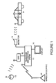
- Figure 1 is a simplified block diagram that shows a navigation system that takes into account dynamic road conditions in accordance with a preferred embodiment of the present invention.
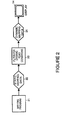
- Figure 2 is a simplified block diagram showing information flow in a navigation system so as to take into account dynamic road conditions when presenting mapping information to a user in accordance with a preferred embodiment of the present invention.
- Figure 3 is a simplified block diagram showing information flow in a navigation system so as to take into account dynamic road conditions when routing information for a user in accordance with a preferred embodiment of the present invention.
- FIG. 1 is a simplified block diagram that shows a navigation system that takes into account dynamic road conditions.
- Global positioning system (GPS) satellites represented by a GPS satellite 15 provide positioning information to a GPS receiver 12.
- GPS Global positioning system
- a transceiver and computing system 11 receives positioning information from GPS receiver 12 and uses the positioning information for mapping and routing.
- the mapping and routing information is displayed to a user via a display 14.
- GPS receiver 12, transceiver and computing system 11 and display 14 can be integrated into a single hardware package.
- GPS receiver 12 can be a separate hardware system connectable to transceiver and computing system 11.
- display 14 can be integrated with transceiver and computing system 11 (e.g., as in a laptop or handheld computing system) or may be housed separately (for example in the dashboard of a car).
- a detector 13 is used to detect dynamic road conditions in the immediate surrounding area of a vehicle in which transceiver and computing system 11 resides.
- Detector 13 is, for example, a safety warning system (SWS) compatible "smart" detector.
- SWS safety warning system
- a "smart" detector encounters a signal known as a continuous wave on the frequency used by SWS transmitters, it stops scanning and waits for a message display code. Depending on the signal from the transmitter, the detector can display the message category or one of 60 messages.
- the smart detector can warn, for example, of an upcoming hazard, such as a utility crew at work, severe weather conditions or a deer-crossing area.
- An SWS receiver can also describe traffic delays, detours and even roadside services
- SWS transmitters are often resident in emergency vehicles (represented in Figure 1 by emergency vehicle 17) such as police cars, fire trucks and ambulances. Different signals are transmitted depending upon whether the emergency vehicle is on the move with sirens and emergency lights activated or when stopped at the scene of an accident or other hazardous situation. SWS transmitters are also used to warn of a train approaching a crossing, ice-prone bridges, blind intersections, sharp curves, rock slides, poor driving conditions, school buses, school zones and transportation of oversize loads.
- emergency vehicles represented in Figure 1 by emergency vehicle 17
- emergency vehicle 17 such as police cars, fire trucks and ambulances. Different signals are transmitted depending upon whether the emergency vehicle is on the move with sirens and emergency lights activated or when stopped at the scene of an accident or other hazardous situation. SWS transmitters are also used to warn of a train approaching a crossing, ice-prone bridges, blind intersections, sharp curves, rock slides, poor driving conditions, school buses, school zones and transportation of oversize loads.
- a SWS transmitter can follow an initial message with a second message.
- the first message might indicate that a vehicle is approaching a work area or school zone
- the follow-up message can include the speed limit for the location.
- the SWS transmitter is typically stationary.
- the transmitter is within a moving vehicle.
- detector 13 could be another type of detector, for example a radar detector that warns a user of speed traps.
- Transceiver and computing system 11 integrates the information provided by detector 13 into the maps and routing information used by transceiver and computing system 11. Additionally, this information is uploaded to wireless service 16 for broadcast to other vehicles in the vicinity or to any other vehicles to which the information about dynamic road conditions is pertinent.
- Transceiver and computing system is in communication with wireless service 16.
- Wireless service 16 accumulates information related to dynamic road conditions from vehicles equipped with navigation systems similar to transceiving and computing system 11 shown in Figure 1 .
- the information related to dynamic road conditions includes, for example, information about road construction, accidents and slow traffic, etc. obtained from an SWS detector or other detector.
- the information can also include the traveling speed of the vehicle.
- wireless service 16 can obtain additional information from other sources such as state or county transportation services, weather stations, traffic reports and so on. This information is accumulated by wireless service 16 and then forwarded to vehicles to which the information applies.
- the information is used to dynamically update mapping information and routing information.
- FIG. 2 shows information flow within transceiver and computing system 11 when presenting mapping information to a user.
- a mapping program 21 resides within transceiver and computing system 11. Mapping program 21 generates static mapping data 22.
- mapping program 21 is a standard mapping program such as Street Atlas USA or AAA Map'n'Go available from DeLorme.
- mapping program 21 is a mapping program designed specifically for use when taking into account dynamic road conditions.
- a filter for dynamic road conditions 23 receives static mapping data 22 and generates dynamic mapping data 24.
- dynamic mapping data 24 includes static mapping data 22 plus the addition of information about road construction, accidents and slow traffic, etc. obtained from detector 13 or wireless service 16.
- Dynamic mapping data 24 is presented to the user via display 14.
- Dynamic mapping data 24, for example, is displayed in the form of a recommended route, or as a map display that includes information about dynamic road conditions.
- FIG. 3 shows information flow within transceiver and computing system 11 when preparing routing information for a user.
- Mapping program 21 generates routing data 32 using static mapping data.
- routing data 32 is a subset of all available static mapping data.
- Filter for dynamic road conditions 23 receives routing data 32 and generates dynamic routing data 34.
- dynamic routing data 34 includes routing data 32 adjusted for available information about dynamic road conditions such as road construction, accidents and slow traffic, etc. obtained from detector 13 or wireless service 16.
- the information about dynamic road conditions is used, for example, to adjust estimated travel speeds across roads and highways used when routing selection module 36 selects an optimum route 36 between two locations.
- the information about dynamic road conditions is used by routing selection module 36 to present warnings to a user about possible obstacles, hazards and so on that are present at locations along a selected route.
- routing data 3.2 can be directions to a location or a subset of directions to a location (e.g., a warning about an upcoming turn).
- dynamic routing data can be used to determine whether alternative directions are preferable or to generate warnings to be issued while the user is traveling a particular route. These warnings can be displayed to a user using display 14 or spoken to a user using computer generated speech technology.
- FIGS. 1 and Figure 3 show embodiments of the present invention where filter for dynamic road conditions 23 is used to modify information obtained from mapping program 21, as will be understood by persons of ordinary skill in the art, in alternative embodiments of the present invention, the functionality of filter for dynamic road conditions 23 can be integrated into mapping program 21.
Claims (5)
- Verfahren zur Darstellung von Kartierungsinformationen für einen Benutzer, umfassend den folgenden Schritt:(a) Erhalten von dynamischen Straßenbedingungen von einem ersten Detektor (13), wobei der erste Detektor (13) ein Sicherheitswarnsystem-Detektor ist, der ein Signal von einem Sicherheitswarnsystem-Transmitter oder einem Radardetektor erfasst,(b) Integrieren von Informationen über die dynamischen Straßenbedingungen in statische Kartierungsdaten (22), um dynamische Kartierungsdaten (24) zu erzeugen; und(c) Anzeigen der dynamischen Kartierungsdaten (24) an einen Benutzer über ein Display (14), wobei die dynamischen Straßenbedingungen Informationen in Bezug auf mindestens eines der folgenden Faktoren umfassen: Versorgungsarbeiten, Straßenbau oder -instandhaltung, Straßen-Gefahrenzonen, wetterbedingte Gefahren, extreme Wetterbedingungen, sich schnell oder langsam bewegende Fahrzeuge, Umleitungen, Bereitschaftsdienste, Unfall, gefährliche Situationen, Züge, die sich Übergängen nähern, Radarfallen, Wildwechselbereiche, glatteisanfällige Brücken, unübersichtliche Kreuzungen, scharfe Kurven, bevorstehende Abzweigungen, Steinschläge, Schulbusse, Schulbereiche, Verkehrsberichte, Informationen über überdimensionierte Ladungen und variable Geschwindigkeitsbegrenzungen; und(d) Übermitteln der Informationen über dynamische Straßenbedingungen an einen drahtlosen Dienst (16) in Kommunikation mit einem Sendeempfänger und einem Computersystem (11), der Informationen über dynamische Bedingungen sammelt.
- Verfahren nach Anspruch 1, zusätzlich umfassend:(d) Verwenden von Positionierungsinformationen, um dem Benutzer auch eine gegenwärtige Position in Bezug auf die dynamischen Kartierungsdaten (24) anzuzeigen.
- Verfahren nach Anspruch 1 oder Anspruch 2, zusätzlich umfassend: den folgenden Schritt, der vor dem Schritt (b) durchgeführt wird: '
Erhalten der dynamischen Straßenbedingungen von einem zweiten Detektor (13), der dynamische Straßenbedingungen erfasst. - Navigationssystem, umfassend:eine Kartierungsdaten-Quelle (21), um statische Kartierungsdaten (22) bereitzustellen;einen Detektor (13), der dynamische Straßenbedingungen erfasst, wobei der Detektor (13) ein Sicherheitswarnsystem-Detektor ist, der konfiguriert ist, um ein Signal von einem Sicherheitswarnsystem-Transmitter oder einem Radardetektor zu erfassen,Integrationsmittel (23), um die Informationen über dynamische Straßenbedingungen in die statischen Kartierungsdaten (22) zu integrieren;dadurch gekennzeichnet, dass es weiter einen Sendeempfänger und ein Computersystem (11) umfasst, um die Informationen über dynamische Straßenbedingungen an einen drahtlosen Dienst (16) zu übermitteln, der Informationen über dynamische Straßenbedingungen sammelt.
- Navigationssystem nach Anspruch 4, zusätzlich umfassend einen Empfänger (11), der Informationen über dynamische Straßenbedingungen vom drahtlosen Dienst (16) empfängt, der Informationen über dynamische Straßenbedingungen sammelt.
Applications Claiming Priority (2)
| Application Number | Priority Date | Filing Date | Title |
|---|---|---|---|
| US09/834,341 US6662106B2 (en) | 2001-04-13 | 2001-04-13 | Navigation system that takes into account dynamic road conditions |
| US834341 | 2001-04-13 |
Related Child Applications (1)
| Application Number | Title | Priority Date | Filing Date |
|---|---|---|---|
| EP10012864.4 Division-Into | 2010-10-01 |
Publications (3)
| Publication Number | Publication Date |
|---|---|
| EP1249810A2 EP1249810A2 (de) | 2002-10-16 |
| EP1249810A3 EP1249810A3 (de) | 2004-05-26 |
| EP1249810B1 true EP1249810B1 (de) | 2013-11-06 |
Family
ID=25266703
Family Applications (1)
| Application Number | Title | Priority Date | Filing Date |
|---|---|---|---|
| EP02252481.3A Expired - Fee Related EP1249810B1 (de) | 2001-04-13 | 2002-04-05 | Navigationssystem mit dynamischen Strassenbedingungen |
Country Status (3)
| Country | Link |
|---|---|
| US (1) | US6662106B2 (de) |
| EP (1) | EP1249810B1 (de) |
| JP (1) | JP2002365072A (de) |
Families Citing this family (41)
| Publication number | Priority date | Publication date | Assignee | Title |
|---|---|---|---|---|
| US8352400B2 (en) | 1991-12-23 | 2013-01-08 | Hoffberg Steven M | Adaptive pattern recognition based controller apparatus and method and human-factored interface therefore |
| US10361802B1 (en) | 1999-02-01 | 2019-07-23 | Blanding Hovenweep, Llc | Adaptive pattern recognition based control system and method |
| US7904187B2 (en) | 1999-02-01 | 2011-03-08 | Hoffberg Steven M | Internet appliance system and method |
| JP3866532B2 (ja) * | 2001-06-13 | 2007-01-10 | 富士通株式会社 | 移動体安全運行支援装置およびコンピュータプログラム |
| US7027915B2 (en) | 2002-10-09 | 2006-04-11 | Craine Dean A | Personal traffic congestion avoidance system |
| US6845317B2 (en) * | 2002-11-04 | 2005-01-18 | Dean A. Craine | Navigational-based speed limit recording and warning system |
| US20050096840A1 (en) * | 2003-11-03 | 2005-05-05 | Simske Steven J. | Navigation routing system and method |
| US7949726B2 (en) * | 2004-03-12 | 2011-05-24 | Ocean And Coastal Environmental Sensing, Inc. | System and method for delivering information on demand |
| US7298248B2 (en) * | 2004-07-19 | 2007-11-20 | K40 Electronics | Communication system for vehicles |
| US20060242108A1 (en) * | 2005-04-25 | 2006-10-26 | The Boeing Company | Advanced ground transportation management |
| US7761226B1 (en) | 2005-07-27 | 2010-07-20 | The United States Of America As Represented By The Secretary Of The Navy | Interactive pedestrian routing system |
| US11351863B2 (en) | 2005-11-17 | 2022-06-07 | Invently Automotive Inc. | Vehicle power management system |
| US11186175B2 (en) | 2005-11-17 | 2021-11-30 | Invently Automotive Inc. | Vehicle power management system |
| US11345236B2 (en) | 2005-11-17 | 2022-05-31 | Invently Automotive Inc. | Electric vehicle power management system |
| US11214144B2 (en) | 2005-11-17 | 2022-01-04 | Invently Automotive Inc. | Electric vehicle power management system |
| US11180025B2 (en) | 2005-11-17 | 2021-11-23 | Invently Automotive Inc. | Electric vehicle power management system |
| US11207980B2 (en) | 2005-11-17 | 2021-12-28 | Invently Automotive Inc. | Vehicle power management system responsive to traffic conditions |
| US20070208506A1 (en) * | 2006-03-03 | 2007-09-06 | Ford Motor Company | Travel system for a vehicle |
| US8063792B2 (en) * | 2006-09-18 | 2011-11-22 | Neptune Technology Group, Inc. | Field service and meter reading devices with GPS functionality |
| US7825782B2 (en) * | 2007-03-20 | 2010-11-02 | Ford Global Technologies, Llc | Device and method for wireless vehicle communication |
| US7928891B2 (en) * | 2007-09-18 | 2011-04-19 | Edward Zheng | GPS with radar detector |
| DE102008013493A1 (de) * | 2008-03-10 | 2009-09-17 | Deutsche Telekom Ag | Verfahren zur sprechenden dynamischen Navigation mit statistischen Verkehrsdaten und dynamischer Selektion |
| TWI397675B (zh) * | 2008-11-01 | 2013-06-01 | Ming Han Chang | Scheduling system and itinerary method |
| US8373588B2 (en) * | 2009-02-20 | 2013-02-12 | Escort Inc. | Wireless connectivity in a radar detector |
| US8612131B2 (en) * | 2009-03-26 | 2013-12-17 | B&C Electronic Engineering, Inc. | Emergency and traffic alert system |
| US20100250111A1 (en) * | 2009-03-26 | 2010-09-30 | B&C Electronic Engineering, Inc. | Emergency and traffic alert system |
| KR101188104B1 (ko) * | 2009-05-18 | 2012-10-05 | 팅크웨어(주) | 동적 광고 방법 및 장치 |
| CN101763729B (zh) * | 2009-12-29 | 2012-12-12 | 北京世纪高通科技有限公司 | 路况数据特征值提取的方法和装置 |
| US9026360B2 (en) * | 2013-06-05 | 2015-05-05 | General Electric Company | Systems and methods for providing constant warning time at crossings |
| EP2940672B1 (de) * | 2014-04-29 | 2018-03-07 | Fujitsu Limited | Fahrzeugsicherheitssystem |
| US9869564B2 (en) | 2014-09-30 | 2018-01-16 | Apple Inc. | Method and apparatus for providing dynamic warnings for navigations |
| US11100797B2 (en) | 2015-06-05 | 2021-08-24 | Apple Inc. | Traffic notifications during navigation |
| CN105243835A (zh) * | 2015-09-25 | 2016-01-13 | 成都曜诚通科技有限公司 | 高效集成式交通信息化系统 |
| US10460534B1 (en) | 2015-10-26 | 2019-10-29 | Allstate Insurance Company | Vehicle-to-vehicle accident detection |
| CN105976609A (zh) * | 2015-11-06 | 2016-09-28 | 乐卡汽车智能科技(北京)有限公司 | 一种车辆数据处理系统及方法 |
| CN105989712A (zh) * | 2015-11-06 | 2016-10-05 | 乐卡汽车智能科技(北京)有限公司 | 一种车辆数据处理的方法及车辆终端 |
| CN105976631A (zh) * | 2015-11-06 | 2016-09-28 | 乐卡汽车智能科技(北京)有限公司 | 一种车辆数据处理方法及车辆终端 |
| FR3045815A1 (fr) * | 2015-12-17 | 2017-06-23 | Michelin & Cie | Procede de representation cartographique de donnees concernant l'etat d'une route |
| US10408937B2 (en) | 2016-09-20 | 2019-09-10 | Ford Global Technologies, Llc | Metal bridge detection systems and methods |
| US11186295B2 (en) | 2017-12-22 | 2021-11-30 | Veripat, LLC | Vehicle with escape feature using synthesized vehicle view |
| CN112595331A (zh) * | 2020-12-14 | 2021-04-02 | 上海市政工程设计研究总院(集团)有限公司 | 计算机视频与地图法融合的机动车动态定位与导航系统 |
Citations (4)
| Publication number | Priority date | Publication date | Assignee | Title |
|---|---|---|---|---|
| GB2250619A (en) * | 1990-10-31 | 1992-06-10 | Norm Pacific Automat Corp | Traffic information inter-vehicle transference and a navigation system |
| US5850190A (en) * | 1997-03-06 | 1998-12-15 | Sony Corporation | Traffic information pager |
| DE19746784A1 (de) * | 1997-10-23 | 1999-04-29 | Christian Schaeffer | Signalisierungseinrichtung |
| US6204798B1 (en) * | 1999-04-14 | 2001-03-20 | Fleming, Iii Hoyt A. | Method and apparatus for alerting an operator of a motor vehicle to an incoming radar signal |
Family Cites Families (7)
| Publication number | Priority date | Publication date | Assignee | Title |
|---|---|---|---|---|
| DE19650844C2 (de) * | 1996-11-27 | 2003-09-25 | Mannesmann Ag | Verfahren zur Ermittlung von Fahrtroutendaten |
| US6252544B1 (en) * | 1998-01-27 | 2001-06-26 | Steven M. Hoffberg | Mobile communication device |
| JPH11224047A (ja) * | 1998-02-06 | 1999-08-17 | Matsushita Electric Ind Co Ltd | 地図情報提供方法及びそれに用いられる端末装置 |
| JPH11281377A (ja) * | 1998-03-31 | 1999-10-15 | Sony Corp | 地図情報取得方法、ナビゲーション方法、地域情報提供方法、ナビゲーション装置、地域情報提供装置及び自動車 |
| EP1077362B1 (de) * | 1999-08-17 | 2004-05-26 | Toyota Jidosha Kabushiki Kaisha | Routenführungsvorrichtung |
| US6377210B1 (en) * | 2000-02-25 | 2002-04-23 | Grey Island Systems, Inc. | Automatic mobile object locator apparatus and method |
| US6484092B2 (en) * | 2001-03-28 | 2002-11-19 | Intel Corporation | Method and system for dynamic and interactive route finding |
-
2001
- 2001-04-13 US US09/834,341 patent/US6662106B2/en not_active Expired - Lifetime
-
2002
- 2002-03-20 JP JP2002077523A patent/JP2002365072A/ja active Pending
- 2002-04-05 EP EP02252481.3A patent/EP1249810B1/de not_active Expired - Fee Related
Patent Citations (4)
| Publication number | Priority date | Publication date | Assignee | Title |
|---|---|---|---|---|
| GB2250619A (en) * | 1990-10-31 | 1992-06-10 | Norm Pacific Automat Corp | Traffic information inter-vehicle transference and a navigation system |
| US5850190A (en) * | 1997-03-06 | 1998-12-15 | Sony Corporation | Traffic information pager |
| DE19746784A1 (de) * | 1997-10-23 | 1999-04-29 | Christian Schaeffer | Signalisierungseinrichtung |
| US6204798B1 (en) * | 1999-04-14 | 2001-03-20 | Fleming, Iii Hoyt A. | Method and apparatus for alerting an operator of a motor vehicle to an incoming radar signal |
Also Published As
| Publication number | Publication date |
|---|---|
| JP2002365072A (ja) | 2002-12-18 |
| US6662106B2 (en) | 2003-12-09 |
| EP1249810A2 (de) | 2002-10-16 |
| US20020152026A1 (en) | 2002-10-17 |
| EP1249810A3 (de) | 2004-05-26 |
Similar Documents
| Publication | Publication Date | Title |
|---|---|---|
| EP1249810B1 (de) | Navigationssystem mit dynamischen Strassenbedingungen | |
| US7925423B2 (en) | System and method for traffic condition detection | |
| US6411896B1 (en) | Method and system for providing warnings to drivers of vehicles about slow-moving, fast-moving, or stationary objects located around the vehicles | |
| US6895332B2 (en) | GPS-based vehicle warning and location system and method | |
| US6583734B2 (en) | Enhanced vehicle hazard warning and safety features integrated with an onboard navigation system | |
| US7099776B2 (en) | GPS-based vehicle warning and location system and method | |
| US5844505A (en) | Automobile navigation system | |
| US6442473B1 (en) | Method and apparatus for presenting traffic information in a vehicle | |
| US7990286B2 (en) | Vehicle positioning system using location codes in passive tags | |
| US8108135B2 (en) | Traffic congestion degree determination device, traffic congestion degree notification device, and program | |
| US20030128139A1 (en) | Apparatus and method for providing travel information | |
| US6636799B2 (en) | Method and apparatus for modification of vehicular navigation information | |
| KR20010076344A (ko) | 자동차 대화형 통신 시스템 | |
| KR20020021691A (ko) | 단거리 고속통신 장치를 이용한 차량항법 서비스 장치 및그 방법 | |
| US20030128135A1 (en) | Apparatus and method for providing for the remote control of traffic control devices along a travel route | |
| JP2002123896A (ja) | 車両用衝突警報装置 | |
| US7010397B1 (en) | Utilization by a vehicle of wireless data from intelligent street signs | |
| JP2008184129A (ja) | 車内騒音制御装置 | |
| US20150134240A1 (en) | Imitation sound generation system and map database | |
| KR20060064372A (ko) | 차량간 통신장치 및 그 방법 | |
| JPH1096643A (ja) | ナビゲーション装置 | |
| JP2002195840A (ja) | 車両用ナビゲーションシステム | |
| Regan | A Sign of the Future I: Intelligent Transport Systems | |
| JP2002269681A (ja) | 道路規制予告通知システム及び道路規制予告通知方法 | |
| KR101042034B1 (ko) | 다른 차량의 운전자 혹은 탑승자에게 차량 운행관련 정보와 기타 정보를 제공하기 위한 차량 설치형 정보 안내 장치 및 차량 운행-관련 정보 제공 시스템 |
Legal Events
| Date | Code | Title | Description |
|---|---|---|---|
| PUAI | Public reference made under article 153(3) epc to a published international application that has entered the european phase |
Free format text: ORIGINAL CODE: 0009012 |
|
| AK | Designated contracting states |
Kind code of ref document: A2 Designated state(s): AT BE CH CY DE DK ES FI FR GB GR IE IT LI LU MC NL PT SE TR |
|
| AX | Request for extension of the european patent |
Free format text: AL;LT;LV;MK;RO;SI |
|
| PUAL | Search report despatched |
Free format text: ORIGINAL CODE: 0009013 |
|
| AK | Designated contracting states |
Kind code of ref document: A3 Designated state(s): AT BE CH CY DE DK ES FI FR GB GR IE IT LI LU MC NL PT SE TR |
|
| AX | Request for extension of the european patent |
Extension state: AL LT LV MK RO SI |
|
| 17P | Request for examination filed |
Effective date: 20041105 |
|
| AKX | Designation fees paid |
Designated state(s): DE FR GB |
|
| 17Q | First examination report despatched |
Effective date: 20070626 |
|
| RAP1 | Party data changed (applicant data changed or rights of an application transferred) |
Owner name: HEWLETT-PACKARD DEVELOPMENT COMPANY, L.P. |
|
| REG | Reference to a national code |
Ref country code: DE Ref legal event code: R079 Ref document number: 60245716 Country of ref document: DE Free format text: PREVIOUS MAIN CLASS: G08G0001096900 Ipc: G01C0021260000 |
|
| RIC1 | Information provided on ipc code assigned before grant |
Ipc: G08G 1/0967 20060101ALI20130314BHEP Ipc: G01C 21/26 20060101AFI20130314BHEP |
|
| GRAP | Despatch of communication of intention to grant a patent |
Free format text: ORIGINAL CODE: EPIDOSNIGR1 |
|
| INTG | Intention to grant announced |
Effective date: 20130523 |
|
| GRAS | Grant fee paid |
Free format text: ORIGINAL CODE: EPIDOSNIGR3 |
|
| GRAA | (expected) grant |
Free format text: ORIGINAL CODE: 0009210 |
|
| AK | Designated contracting states |
Kind code of ref document: B1 Designated state(s): DE FR GB |
|
| REG | Reference to a national code |
Ref country code: GB Ref legal event code: FG4D |
|
| REG | Reference to a national code |
Ref country code: DE Ref legal event code: R096 Ref document number: 60245716 Country of ref document: DE Effective date: 20140102 |
|
| REG | Reference to a national code |
Ref country code: DE Ref legal event code: R097 Ref document number: 60245716 Country of ref document: DE |
|
| PLBE | No opposition filed within time limit |
Free format text: ORIGINAL CODE: 0009261 |
|
| STAA | Information on the status of an ep patent application or granted ep patent |
Free format text: STATUS: NO OPPOSITION FILED WITHIN TIME LIMIT |
|
| 26N | No opposition filed |
Effective date: 20140807 |
|
| REG | Reference to a national code |
Ref country code: DE Ref legal event code: R097 Ref document number: 60245716 Country of ref document: DE Effective date: 20140807 |
|
| REG | Reference to a national code |
Ref country code: FR Ref legal event code: PLFP Year of fee payment: 15 |
|
| REG | Reference to a national code |
Ref country code: FR Ref legal event code: PLFP Year of fee payment: 16 |
|
| REG | Reference to a national code |
Ref country code: FR Ref legal event code: PLFP Year of fee payment: 17 |
|
| PGFP | Annual fee paid to national office [announced via postgrant information from national office to epo] |
Ref country code: GB Payment date: 20180321 Year of fee payment: 17 |
|
| PGFP | Annual fee paid to national office [announced via postgrant information from national office to epo] |
Ref country code: FR Payment date: 20180322 Year of fee payment: 17 |
|
| PGFP | Annual fee paid to national office [announced via postgrant information from national office to epo] |
Ref country code: DE Payment date: 20180320 Year of fee payment: 17 |
|
| REG | Reference to a national code |
Ref country code: DE Ref legal event code: R119 Ref document number: 60245716 Country of ref document: DE |
|
| GBPC | Gb: european patent ceased through non-payment of renewal fee |
Effective date: 20190405 |
|
| PG25 | Lapsed in a contracting state [announced via postgrant information from national office to epo] |
Ref country code: GB Free format text: LAPSE BECAUSE OF NON-PAYMENT OF DUE FEES Effective date: 20190405 Ref country code: DE Free format text: LAPSE BECAUSE OF NON-PAYMENT OF DUE FEES Effective date: 20191101 |
|
| PG25 | Lapsed in a contracting state [announced via postgrant information from national office to epo] |
Ref country code: FR Free format text: LAPSE BECAUSE OF NON-PAYMENT OF DUE FEES Effective date: 20190430 |