WO2020161886A1 - 移動体の位置特定システムおよび位置特定システムに使用される移動体 - Google Patents
移動体の位置特定システムおよび位置特定システムに使用される移動体 Download PDFInfo
- Publication number
- WO2020161886A1 WO2020161886A1 PCT/JP2019/004628 JP2019004628W WO2020161886A1 WO 2020161886 A1 WO2020161886 A1 WO 2020161886A1 JP 2019004628 W JP2019004628 W JP 2019004628W WO 2020161886 A1 WO2020161886 A1 WO 2020161886A1
- Authority
- WO
- WIPO (PCT)
- Prior art keywords
- wireless communication
- information
- time
- unit
- communication means
- Prior art date
- Legal status (The legal status is an assumption and is not a legal conclusion. Google has not performed a legal analysis and makes no representation as to the accuracy of the status listed.)
- Ceased
Links
Images



Classifications
-
- G—PHYSICS
- G01—MEASURING; TESTING
- G01S—RADIO DIRECTION-FINDING; RADIO NAVIGATION; DETERMINING DISTANCE OR VELOCITY BY USE OF RADIO WAVES; LOCATING OR PRESENCE-DETECTING BY USE OF THE REFLECTION OR RERADIATION OF RADIO WAVES; ANALOGOUS ARRANGEMENTS USING OTHER WAVES
- G01S5/00—Position-fixing by co-ordinating two or more direction or position line determinations; Position-fixing by co-ordinating two or more distance determinations
- G01S5/0009—Transmission of position information to remote stations
- G01S5/0045—Transmission from base station to mobile station
- G01S5/0063—Transmission from base station to mobile station of measured values, i.e. measurement on base station and position calculation on mobile
-
- G—PHYSICS
- G01—MEASURING; TESTING
- G01S—RADIO DIRECTION-FINDING; RADIO NAVIGATION; DETERMINING DISTANCE OR VELOCITY BY USE OF RADIO WAVES; LOCATING OR PRESENCE-DETECTING BY USE OF THE REFLECTION OR RERADIATION OF RADIO WAVES; ANALOGOUS ARRANGEMENTS USING OTHER WAVES
- G01S1/00—Beacons or beacon systems transmitting signals having a characteristic or characteristics capable of being detected by non-directional receivers and defining directions, positions, or position lines fixed relatively to the beacon transmitters; Receivers co-operating therewith
- G01S1/02—Beacons or beacon systems transmitting signals having a characteristic or characteristics capable of being detected by non-directional receivers and defining directions, positions, or position lines fixed relatively to the beacon transmitters; Receivers co-operating therewith using radio waves
- G01S1/04—Details
- G01S1/042—Transmitters
-
- G—PHYSICS
- G01—MEASURING; TESTING
- G01S—RADIO DIRECTION-FINDING; RADIO NAVIGATION; DETERMINING DISTANCE OR VELOCITY BY USE OF RADIO WAVES; LOCATING OR PRESENCE-DETECTING BY USE OF THE REFLECTION OR RERADIATION OF RADIO WAVES; ANALOGOUS ARRANGEMENTS USING OTHER WAVES
- G01S11/00—Systems for determining distance or velocity not using reflection or reradiation
- G01S11/02—Systems for determining distance or velocity not using reflection or reradiation using radio waves
- G01S11/08—Systems for determining distance or velocity not using reflection or reradiation using radio waves using synchronised clocks
-
- G—PHYSICS
- G01—MEASURING; TESTING
- G01S—RADIO DIRECTION-FINDING; RADIO NAVIGATION; DETERMINING DISTANCE OR VELOCITY BY USE OF RADIO WAVES; LOCATING OR PRESENCE-DETECTING BY USE OF THE REFLECTION OR RERADIATION OF RADIO WAVES; ANALOGOUS ARRANGEMENTS USING OTHER WAVES
- G01S5/00—Position-fixing by co-ordinating two or more direction or position line determinations; Position-fixing by co-ordinating two or more distance determinations
- G01S5/02—Position-fixing by co-ordinating two or more direction or position line determinations; Position-fixing by co-ordinating two or more distance determinations using radio waves
- G01S5/0205—Details
- G01S5/021—Calibration, monitoring or correction
-
- G—PHYSICS
- G01—MEASURING; TESTING
- G01S—RADIO DIRECTION-FINDING; RADIO NAVIGATION; DETERMINING DISTANCE OR VELOCITY BY USE OF RADIO WAVES; LOCATING OR PRESENCE-DETECTING BY USE OF THE REFLECTION OR RERADIATION OF RADIO WAVES; ANALOGOUS ARRANGEMENTS USING OTHER WAVES
- G01S5/00—Position-fixing by co-ordinating two or more direction or position line determinations; Position-fixing by co-ordinating two or more distance determinations
- G01S5/02—Position-fixing by co-ordinating two or more direction or position line determinations; Position-fixing by co-ordinating two or more distance determinations using radio waves
- G01S5/0205—Details
- G01S5/0221—Receivers
-
- G—PHYSICS
- G01—MEASURING; TESTING
- G01S—RADIO DIRECTION-FINDING; RADIO NAVIGATION; DETERMINING DISTANCE OR VELOCITY BY USE OF RADIO WAVES; LOCATING OR PRESENCE-DETECTING BY USE OF THE REFLECTION OR RERADIATION OF RADIO WAVES; ANALOGOUS ARRANGEMENTS USING OTHER WAVES
- G01S5/00—Position-fixing by co-ordinating two or more direction or position line determinations; Position-fixing by co-ordinating two or more distance determinations
- G01S5/02—Position-fixing by co-ordinating two or more direction or position line determinations; Position-fixing by co-ordinating two or more distance determinations using radio waves
- G01S5/14—Determining absolute distances from a plurality of spaced points of known location
-
- G—PHYSICS
- G05—CONTROLLING; REGULATING
- G05D—SYSTEMS FOR CONTROLLING OR REGULATING NON-ELECTRIC VARIABLES
- G05D1/00—Control of position, course, altitude or attitude of land, water, air or space vehicles, e.g. using automatic pilots
- G05D1/02—Control of position or course in two dimensions
- G05D1/021—Control of position or course in two dimensions specially adapted to land vehicles
- G05D1/0276—Control of position or course in two dimensions specially adapted to land vehicles using signals provided by a source external to the vehicle
- G05D1/0278—Control of position or course in two dimensions specially adapted to land vehicles using signals provided by a source external to the vehicle using satellite positioning signals, e.g. GPS
-
- G—PHYSICS
- G05—CONTROLLING; REGULATING
- G05D—SYSTEMS FOR CONTROLLING OR REGULATING NON-ELECTRIC VARIABLES
- G05D1/00—Control of position, course, altitude or attitude of land, water, air or space vehicles, e.g. using automatic pilots
- G05D1/02—Control of position or course in two dimensions
- G05D1/021—Control of position or course in two dimensions specially adapted to land vehicles
- G05D1/0276—Control of position or course in two dimensions specially adapted to land vehicles using signals provided by a source external to the vehicle
- G05D1/028—Control of position or course in two dimensions specially adapted to land vehicles using signals provided by a source external to the vehicle using a RF signal
-
- G—PHYSICS
- G05—CONTROLLING; REGULATING
- G05D—SYSTEMS FOR CONTROLLING OR REGULATING NON-ELECTRIC VARIABLES
- G05D1/00—Control of position, course, altitude or attitude of land, water, air or space vehicles, e.g. using automatic pilots
- G05D1/20—Control system inputs
- G05D1/24—Arrangements for determining position or orientation
- G05D1/247—Arrangements for determining position or orientation using signals provided by artificial sources external to the vehicle, e.g. navigation beacons
-
- G—PHYSICS
- G05—CONTROLLING; REGULATING
- G05D—SYSTEMS FOR CONTROLLING OR REGULATING NON-ELECTRIC VARIABLES
- G05D1/00—Control of position, course, altitude or attitude of land, water, air or space vehicles, e.g. using automatic pilots
- G05D1/20—Control system inputs
- G05D1/24—Arrangements for determining position or orientation
- G05D1/247—Arrangements for determining position or orientation using signals provided by artificial sources external to the vehicle, e.g. navigation beacons
- G05D1/248—Arrangements for determining position or orientation using signals provided by artificial sources external to the vehicle, e.g. navigation beacons generated by satellites, e.g. GPS
-
- G—PHYSICS
- G01—MEASURING; TESTING
- G01S—RADIO DIRECTION-FINDING; RADIO NAVIGATION; DETERMINING DISTANCE OR VELOCITY BY USE OF RADIO WAVES; LOCATING OR PRESENCE-DETECTING BY USE OF THE REFLECTION OR RERADIATION OF RADIO WAVES; ANALOGOUS ARRANGEMENTS USING OTHER WAVES
- G01S1/00—Beacons or beacon systems transmitting signals having a characteristic or characteristics capable of being detected by non-directional receivers and defining directions, positions, or position lines fixed relatively to the beacon transmitters; Receivers co-operating therewith
- G01S1/02—Beacons or beacon systems transmitting signals having a characteristic or characteristics capable of being detected by non-directional receivers and defining directions, positions, or position lines fixed relatively to the beacon transmitters; Receivers co-operating therewith using radio waves
- G01S1/68—Marker, boundary, call-sign, or like beacons transmitting signals not carrying directional information
-
- G—PHYSICS
- G01—MEASURING; TESTING
- G01S—RADIO DIRECTION-FINDING; RADIO NAVIGATION; DETERMINING DISTANCE OR VELOCITY BY USE OF RADIO WAVES; LOCATING OR PRESENCE-DETECTING BY USE OF THE REFLECTION OR RERADIATION OF RADIO WAVES; ANALOGOUS ARRANGEMENTS USING OTHER WAVES
- G01S19/00—Satellite radio beacon positioning systems; Determining position, velocity or attitude using signals transmitted by such systems
- G01S19/38—Determining a navigation solution using signals transmitted by a satellite radio beacon positioning system
- G01S19/39—Determining a navigation solution using signals transmitted by a satellite radio beacon positioning system the satellite radio beacon positioning system transmitting time-stamped messages, e.g. GPS [Global Positioning System], GLONASS [Global Orbiting Navigation Satellite System] or GALILEO
- G01S19/42—Determining position
- G01S19/48—Determining position by combining or switching between position solutions derived from the satellite radio beacon positioning system and position solutions derived from a further system
Definitions
- the present invention relates to a system for specifying the position of a moving body such as a vehicle and a moving body used in the system.
- Patent Document 1 discloses the position of the vehicle and the receiver based on the orbit of the GNSS (Global Navigation Satellite System) satellite and the first modified pseudorange that is the pseudorange of the GNSS satellite.
- the clock is calculated, and the pseudo distance is received from the average of the unknown error which is the difference between the two point distances between the positions of the plurality of satellites and the position of the own vehicle, which are less affected by multipath, and the first corrected pseudo distance It is disclosed that the machine clock bias error is obtained, and the position of the host vehicle is recalculated by the second corrected pseudorange obtained by correcting the first corrected pseudorange using this receiver clock bias error. ..
- GNSS Global Navigation Satellite System
- Patent Document 2 when an IMES message is received in an underground space or the like where a signal from a GNSS satellite cannot be received, the coordinate values of the marker are acquired from the IMES message, and a vehicle and a marker are acquired using an image captured by a camera. It is disclosed that the relative position and the relative angle between the two are acquired, and the absolute coordinate value and the heading of the vehicle are calculated.
- the present invention has been made in view of the above points, and makes it possible to specify the position of a moving body even when the position of the moving body cannot be specified using signals from each satellite of GNSS. It is a thing.
- the solution means of the present invention for achieving the above-mentioned object uses a first wireless communication means arranged on a structure and a second wireless communication means arranged on a structure to determine the position of a moving body.
- the target is a system for specifying the position of a moving body to be specified.
- the first wireless communication means has the first position information, which is information on the position where the first wireless communication means is arranged, and the second wireless communication means has the second wireless communication means.
- the second position information which is information related to the position where is arranged, is associated with each other.
- the first wireless communication means has a first time specifying means for specifying a first time
- the second wireless communication means has a second time specifying means for specifying a second time. doing.
- the first wireless communication unit includes a first wireless transmission unit that transmits the first position information and the first time
- the second wireless communication unit includes the second position information.
- a second wireless transmission unit for transmitting the second time and the second time, respectively.
- the mobile body receives the transmitted first position information, the first time, the second position information, and the second time, and a wireless reception unit that receives the first position information and the received first position. It is characterized by having a position specifying processing unit that specifies the position of the moving body based on the position information, the first time, the second position information, and the second time.
- the present invention it becomes possible to specify the position of the mobile body even when the position of the mobile body cannot be specified using the signals from each satellite of GNSS.
- the vehicle acquires information (position information and time information of each satellite of GNSS) transmitted by a plurality of GNSS satellites, and specifies the position of the vehicle (own vehicle) based on this information.
- the vehicle acquires the position identification processing operation of No. 1 and the information (position information, time information, etc. of each wireless communication means) transmitted by a plurality of wireless communication means arranged on a structure (building, etc.) fixed on the ground.
- the second position specifying processing operation for specifying the position of the vehicle (own vehicle) based on this information is switched.
- FIG. 1 is a block diagram showing a schematic configuration of the position identifying system according to the present embodiment.
- the position specifying system includes a plurality of satellites 10, 10,... Of GNSS, a first wireless communication unit 20, a second wireless communication unit 30, and a position specifying unit 40 mounted on a vehicle. It has a structure that includes it.
- GNSS satellites (hereinafter, also simply referred to as satellites) 10, 10,... Have the same configuration.
- satellites 10 will be described as a representative.
- the satellite 10 has a time specifying unit 11 and a GNSS signal transmitting unit 12.
- the satellite 10 may be a satellite such as GPS (Global Positioning System), Galileo, or Glonass.
- the satellite 10 constantly broadcasts (transmits radio waves) a navigation message (satellite signal) to the earth by the GNSS signal transmission unit 12.
- the navigation message includes satellite orbit information (ephemeris or almanac) about the corresponding satellite 10, a correction value of the time specified by the time specifying unit 11, and a correction coefficient of the ionosphere.
- the navigation message is spread by the C/A code, placed on a carrier wave in the L1 band, and constantly broadcast to the earth. Further, the navigation message is spread by a P code (Precision Code), placed on a carrier wave in the L2 band, and constantly broadcast to the earth.
- the time specifying unit 11 specifies the current time with an atomic clock, and this time is included in the navigation message. Therefore, this constantly broadcast time has high accuracy.
- the carrier wave in the L1 band is a composite wave of the sin wave modulated by the C/A code and the cos wave modulated by the P code, and is orthogonally modulated. Further, the carrier wave in the L2 band is a cos wave modulated with a P code and is orthogonally modulated.
- the C/A code and the P code are pseudo noise codes, and are a code string in which -1 and 1 are irregularly arranged periodically.
- FIG. 2 is a diagram showing an example of a state in which the vehicle V is receiving signals from the satellites 10, 10,....
- the vehicle V since the buildings B, B,... Having relatively low heights are lined up on both sides of the road R, the vehicle V reliably receives signals from the respective satellites 10, 10,. ing.
- the first wireless communication means 20 is a wireless transmitter having an antenna fixed to a window, wall surface or the like of a building (structure fixed to the ground) B1.
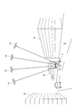
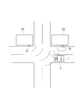
- FIG. 3 is a diagram showing an example of a state in which the vehicle V is receiving a signal from the first wireless communication means 20 arranged in the building B1. Further, FIG. 3 also shows an example of a state in which the vehicle V is receiving a signal from the second wireless communication means 30 which will be described later and is arranged in the building B2.
- FIG. 3 shows the case where the wireless communication means 20 and 30 are arranged only in the two buildings B1 and B2, in the area where the high-rise buildings (buildings) are lined up along the road R, a predetermined number is set.
- Wireless communication means will be installed in each building for each distance.
- the wireless communication means 20 and 30 are arranged only in the two buildings B1 and B2 will be described.
- the first wireless communication means 20 includes a wireless communication means information specifying unit (first wireless communication means information specifying unit) 21, a storage unit (first storage unit) 22, a processing unit 23, A wireless transmission unit (first wireless transmission unit) 24 is provided.
- the wireless communication means information specifying unit 21 is a portion that specifies information (position information, time information, etc.) of the first wireless communication means 20. Therefore, the wireless communication means information specifying unit 21 can also be referred to as time specifying means (first time specifying means). As the operation of specifying this information, the position information (latitude, longitude, altitude) of the first wireless communication means 20 and the current time are calculated by receiving signals from the plurality of satellites 10, 10,.... Further, as a means for receiving signals from the satellites 10, 10,..., The first wireless communication means 20 has a receiving antenna (antenna for receiving signals from the satellites 10, 10,...) Built therein.
- the wireless communication means information specifying unit 21 it is possible to receive information (received by the wireless communication means information specifying unit 21) by wire or wirelessly from a receiving antenna (antenna that receives signals from the satellites 10, 10, etc Installed on the rooftop of the building B1. It may be configured.
- the current time is a delay time required for transmission from the transmission antenna of the first wireless communication means 20 after reception by the antenna that receives signals from the satellites 10, 10,...
- the total amount of time and the time it takes to pass through transmission lines such as electric wires shall be corrected before use.
- the correction may be performed by any functional block in the first wireless communication means 20. That is, the time transmitted from the first wireless communication means 20 at the same time as the position information of the first wireless communication means 20 is the corrected time.
- the position information and the current time of the first wireless communication means 20 are calculated by receiving the signals from the plurality of satellites 10, 10,... Since it is not necessary to store the position information and it is not necessary to provide a unit for measuring the current time, it is possible to simplify the configuration of the first wireless communication unit 20.
- the storage unit 22 is a unit that acquires information from the wireless communication means information specifying unit 21 (position information and time information of the first wireless communication means 20) and stores the information. Since the arrangement position of the first wireless communication unit 20 is immovable (position information that does not change), the storage unit 22 previously stores the position information (position information of the first wireless communication unit 20 (latitude, longitude). , Elevation)) is stored, it is possible to eliminate the above-described position information acquisition operation by the wireless communication means information specifying unit 21.
- the processing unit 23 is a unit that converts various information stored in the storage unit 22 into data that can be wirelessly communicated by the wireless transmission unit 24.
- the wireless transmission unit 24 transmits the data transmitted by the processing unit 23 (data including the information of the first wireless communication unit 20) to a predetermined range toward the road R facing the building B1. Specifically, the electric wave including the data is transmitted to a predetermined range in which the radio wave including the data reaches the position specifying unit 40 included in the vehicle V traveling on the road R.
- the predetermined range over which this radio wave reaches is, for example, 100 m. This value is not limited to this value, and the distance between the arrangement position of the first wireless communication means 20 and the arrangement position of the second wireless communication means 30 described later (in the direction along the extending direction of the road R) The interval) is appropriately determined.
- the buildings B1 and B2 in which the wireless communication units 20 and 30 are arranged and the positions where they are arranged are determined according to the range in which the radio waves from the wireless communication units 20 and 30 reach. That is, it is determined that radio waves transmitted by at least two wireless communication units 20 and 30 always reach the vehicle V traveling on the road R in the predetermined area (area where high-rise buildings are lined up).
- FIG. 4 is an example of a state in which the vehicle V is receiving both the signal from the first wireless communication unit 20 arranged in the building B1 and the signal from the second wireless communication unit 30 arranged in the building B2. It is a top view shown.
- the second wireless communication means 30 is also a wireless transmitter in which an antenna is fixed to a window, a wall surface or the like of a building (structure fixed to the ground) B2 as shown in FIG.
- the building B1 in which the first wireless communication means 20 is arranged and the building B2 in which the second wireless communication means 30 are arranged are different buildings from each other, but the first building is located in the same building.
- the wireless communication means 20 and the second wireless communication means 30 may be arranged together.
- the second wireless communication unit 30 has a wireless communication unit information specifying unit (second wireless communication unit information specifying unit) 31 and a storage unit (similar to the first wireless communication unit 20.
- a second storage unit) 32, a processing unit 33, and a wireless transmission unit (second wireless transmission unit) 34 are provided.
- the wireless communication means information specifying unit 31 is a portion that specifies information (position information, time information, etc.) of the second wireless communication means 30. Therefore, the wireless communication means information specifying unit 31 can also be referred to as time specifying means (second time specifying means). The operation of specifying this information is the same as that of the wireless communication means information specifying unit 21 of the first wireless communication means 20 described above. As for the processing relating to the correction of the time information, the time transmitted at the same time as the position information of the second wireless communication means 30 is the corrected time, as described in the first wireless communication means 20.
- the position information and the current time of the second wireless communication means 30 are calculated by receiving the signals from the plurality of satellites 10, 10,. In other words, it is not necessary to store the position information in the second wireless communication means 30 and it is not necessary to provide means for measuring the current time, so that the configuration of the second wireless communication means 30 is simple. Can be realized.
- the storage unit 32 is a unit that acquires information from the wireless communication means information specifying unit 31 (position information and time information of the second wireless communication means 30) and stores the information. If the storage unit 32 stores the position information (position information (latitude, longitude, altitude) of the second wireless communication unit 30) in advance, the wireless communication unit information specifying unit 31 stores the position information. It is possible to eliminate the acquisition operation.
- the processing unit 33 is a unit that converts various information stored in the storage unit 32 into data that can be wirelessly communicated by the wireless transmission unit 34.
- the wireless transmission unit 34 transmits the data transmitted by the processing unit 33 (data including the information of the second wireless communication unit 30) to the predetermined range toward the road R facing the building B2. Specifically, the electric wave including the data is transmitted to a predetermined range in which the radio wave including the data reaches the position specifying unit 40 included in the vehicle V traveling on the road R.
- the configurations of the first wireless communication unit 20 and the second wireless communication unit 30 are substantially the same, but the communication bands of the data transmitted from the respective wireless transmission units 24 and 34 are mutually different. It is different. Alternatively, they are set as channels different from each other. Thus, when data is received from the wireless transmission units 24 and 34 on the vehicle V side, it is possible to recognize which wireless communication unit 20, 30 transmitted each data. Further, individual ID information is stored in the data so that it can be recognized from which wireless communication means 20, 30 each data is sent even if the same band or the same channel is used. Good.
- the position specifying unit 40 is mounted on the vehicle V, receives signals from the satellites 10, 10,... Or signals from the respective wireless communication means 20, 30 and, based on the information included in the signals, the own vehicle. It specifies the position of.
- the position specifying unit 40 includes a GNSS signal receiving unit 41, a time specifying unit 42, a wireless receiving unit 43, a position specifying processing unit 44, and a storage unit 45.
- the GNSS signal receiving unit 41 receives the navigation message (satellite signal) transmitted by the GNSS signal transmitting unit 12 of each satellite 10, 10,.... That is, the position information (satellite position information) and time information are received from each of the satellites 10, 10,. That is, in a situation where the vehicle V is not traveling in the predetermined area (area where high-rise buildings are lined up), the information transmitted from each satellite 10, 10,... Is received (see the state shown in FIG. 2).
- the time specifying unit 42 extracts time information from the information included in the satellite signal received by the GNSS signal receiving unit 41, and specifies the time at which each satellite 10, 10,... Transmits the information from the information.
- the time specifying unit 42 also specifies the current time (current time in the vehicle V) from the extracted time information.
- the wireless receiver 43 receives the information transmitted by the wireless transmitter 24 of the first wireless communication means 20 and the information transmitted by the wireless transmitter 34 of the second wireless communication means 30, respectively. That is, in a situation where the vehicle V is traveling on the road R in the predetermined area (area where high-rise buildings are lined up), the information transmitted by the wireless transmission units 24 and 34 of the wireless communication units 20 and 30 is received. (See the state shown in FIG. 3).
- the position specifying processing unit 44 can receive the information from the time specifying unit 42 and the information from the wireless receiving unit 43, respectively, and the information from the time specifying unit 42 indicates the time when each satellite 10, 10,... ,
- the GNSS signal receiving unit 41 receives signals from the satellites 10, 10,...
- the vehicle V based on the signals from the satellites 10, 10,.
- Position specification processing is performed.
- the position specifying processing unit 44 receives information from the wireless receiving unit 43 (information from the wireless communication units 20 and 30), the vehicle based on the signals from the wireless communication units 20 and 30. V position specifying processing is performed.
- the basic principle of position identification performed by the position identification processing unit 44 will be described.
- the basic principle of locating the vehicle V based on the signals from the satellites 10, 10,... Will be described as an example, but the basic principle of locating the vehicle V based on the signals from the wireless communication means 20 and 30 will be described. The principle is the same.
- the position specifying processing unit 44 receives the radio waves (satellite signals) from the plurality of satellites 10, 10,..., Thus, the distances (pseudo distances) from the plurality of satellites 10, 10,.
- the position of the vehicle V in which the position specifying unit 40 is mounted is calculated and calculated based on the pseudo distance.
- the position coordinates of the position specifying unit 40 are set to (X, Y, Z), and Let ⁇ T be the time error of a clock (not shown). Further, the position coordinates of the first satellite 10 are (X1, Y1, Z1), and the observation distance is ⁇ 1. The position coordinates of the second satellite 10 are (X2, Y2, Z2), and the observation distance is ⁇ 2. The position coordinates of the third satellite 10 are (X3, Y3, Z3), and the observation distance is ⁇ 3. The position coordinates of the fourth satellite 10 are (X4, Y4, Z4), and the observation distance is ⁇ 4.
- the signals transmitted from the respective satellites 10, 10,... are delayed by the time period during which the radio wave propagates through the distances between the respective satellites 10, 10,. Reach 41. Therefore, if the time required for radio wave propagation for the plurality of satellites 10, 10,... Is obtained, the position of the position identifying unit 40 can be obtained by the positioning calculation.
- ⁇ 1 c ⁇ T+ ⁇ (X1-X) 2 +(Y1-Y) 2 +(Z1-Z) 2 ⁇ 1/2
- ⁇ 2 c ⁇ T+ ⁇ (X2-X) 2 +(Y2-Y) 2 +(Z2-Z) 2 ⁇ 1/2
- ⁇ 3 c ⁇ T+ ⁇ (X3-X) 2 +(Y3-Y) 2 +(Z3-Z) 2 ⁇ 1/2
- ⁇ 4 c ⁇ T+ ⁇ (X4-X) 2 +(Y4-Y) 2 +(Z4-Z) 2 ⁇ 1/2 (4)
- the position (X, Y, Z) of the position specifying unit 40 that is, the position of the vehicle V can be specified.
- the timepiece (not shown) in the position specifying unit 40 is calibrated by ⁇ T. As a result, the accurate current time can be obtained.
- the clock in the position specifying unit 40 (FIG. After calibrating (not shown), the clock is continuously clocked using a self-running reference oscillator (not shown) built in the timepiece (not shown). The frequency accuracy and stability of the self-propelled reference oscillator satisfy the level required for positioning calculation.
- the above is the basic principle of specifying the position of the vehicle V and acquiring the current time based on the signals from the satellites 10, 10,....
- the position of the vehicle V is specified based on the signals from the wireless communication units 20 and 30, the distance from the position specifying unit 40 to the first wireless communication unit 20 and the position specifying unit 40 to the second wireless communication.
- the distance to the means 30 is calculated according to the same principle as the above-mentioned case, and among the intersections of the two spherical surfaces, which are the set of points at these distances, the position on the road R (on the traveling locus of the road R (Intersection point of) can be specified as the position of the vehicle V. That is, the position of the vehicle V can be specified by the well-known map matching process for the intersection point of the spherical surface. Since the signals from the wireless communication means 20 and 30 include time information, the wireless communication means 20 and 30 can also be called time information transmitting terminals.
- the storage unit 45 stores the position information of the vehicle V specified as described above. That is, each time the position of the vehicle V is newly calculated (specified), the stored position information of the vehicle V is updated.
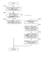
- FIG. 5 is a flowchart showing the procedure of this position specifying processing operation.
- step ST1 a time specifying operation is executed by signals from the satellites 10, 10,....
- the GNSS signal receiving unit 41 receives the signals from the satellites 10, 10,.
- the time specifying unit 42 specifies the current time (time on the vehicle V side).
- step ST2 it is determined whether or not the signals from the satellites 10, 10,... Are properly received and the position information of the satellites 10, 10,. That is, as described above, when the signals from the satellites 10, 10,... Are not blocked by a high-rise building or the like, the GNSS signal receiving unit 41 receives the signals from the satellites 10, 10,. Then, YES is determined in step ST2 assuming that the position information of the satellites 10, 10,... Can be acquired. On the other hand, when the signals from the satellites 10, 10,... Are shielded by high-rise buildings, the GNSS signal receiving unit 41 cannot receive the signals from the satellites 10, 10,. , NO is determined in step ST2, assuming that the position information of the satellites 10, 10,... Can not be acquired.
- step ST2 If the position information of the satellites 10, 10,... Can be acquired and YES is determined in step ST2, the process proceeds to step ST3 to execute the vehicle position specifying operation by calculating the observation distances ⁇ 1 to ⁇ 4 described above. To do.
- step ST1 to ST3 are repeated and the position of the vehicle V is specified. Then, the specified position of the vehicle V is temporarily stored in the storage unit 45 and transmitted to the ECU (not shown) that controls automatic driving.
- step ST2 when the position information of the satellites 10, 10,... Is not available and NO is determined in step ST2, the process proceeds to step ST4, and the first wireless communication means 20 and the second wireless communication means. Receive signal from 30. Then, in step ST5, based on the signal received from the first wireless communication means 20, the time on the vehicle V side and the time on the first wireless communication means 20 side (the first wireless communication means 20 sends the signal The first time difference, which is the time difference from the time when the call was sent) is specified. Similarly, in step ST6, the time on the vehicle V side and the time on the second wireless communication means 30 side (the second wireless communication means 30 based on the signal received from the second wireless communication means 30). Specifies the second time difference, which is the time difference from the time when the signal was transmitted.
- step ST7 the distance between the position specifying unit 40 and the first wireless communication means 20 is calculated based on the specified first time difference, and the distance between the position specifying unit 40 and the second position specifying unit 40 is calculated based on the specified second time difference.
- the distance to the wireless communication means 30 is calculated.
- the position on the road R (the intersection with the traveling locus of the road R) is specified as the position of the vehicle V.
- the first position is set on the structure (building B1) fixed on the ground.
- the wireless transmission unit 24 included in the wireless communication unit 20 of (1) transmits position information (first position information) and time information (first time information) to the wireless reception unit 43 of the vehicle V.
- the wireless transmission unit 34 included in the second wireless communication unit 30 arranged on the structure (building B2) fixed on the ground has position information (second position information) and time information in the wireless reception unit 43 of the vehicle V. (2nd time information) is transmitted.
- the wireless reception unit 43 of the vehicle V receives each position information and each time information
- the position identification processing unit 44 receives each position information received by the wireless reception unit 43 and the time and vehicle of each received time information.
- the position of the vehicle V is specified based on the time difference (first time difference and second time difference) that is the difference from the time on the V side.
- the position of the vehicle V can be specified by using the wireless communication means 20, 30. It will be possible.
- the present embodiment is different from the first embodiment in the form of information transmission/reception between each wireless communication means 20, 30 and the position specifying unit 40. Therefore, here, only the difference between the information transmission/reception mode and the first embodiment will be described.
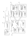
- FIG. 6 is a block diagram showing a schematic configuration of the position identifying system according to the present embodiment.
- the position specifying unit 40 in the present embodiment includes a wireless transmission/reception unit 46 instead of the wireless reception unit 43.
- the wireless transmission/reception unit 46 directs time information (currently recognized by the vehicle V to the wireless communication means 20, 30). Time information).
- the position information cannot be acquired when a plurality of GNSS satellite signals cannot be acquired and the position of the vehicle V (moving body) cannot be specified by calculation.
- the time information transmitted by the signal of at least one satellite 10 or the time information of the satellite signal acquired in the past is transmitted to each wireless communication means 20, 30.
- the clock (not shown) in the position specifying unit 40 is calibrated by the time information acquired in the past, and the clock (not shown) is calibrated. It keeps time by using the self-running reference oscillator built into the.
- each of the wireless communication means 20 and 30 includes wireless transmission/reception units 25 and 35 in place of the wireless transmission units 24 and 34.
- the wireless transmission/reception units 25 and 35 receive the time information from the wireless transmission/reception unit 46
- the wireless transmission/reception units 25 and 35 return the position information of the wireless communication units 20 and 30 to the wireless transmission/reception unit 46 together with the time information. It is like this.
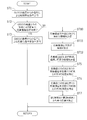
- FIG. 7 is a flowchart showing the procedure of the position specifying processing operation in this embodiment.
- the operations of steps ST1 to ST3 and ST5 to ST7 in this flowchart are the same as the operations of steps ST1 to ST3 and ST5 to ST7 of the flowchart (FIG. 5) in the above-described first embodiment, and therefore the description thereof is omitted here. ..
- step ST10 If the GNSS signal receiving unit 41 cannot acquire the position information of the satellites 10, 10,... And if NO is determined in step ST2, the process proceeds to step ST10, and the wireless transmitting/receiving unit 46 of the position specifying unit 40 operates. , And transmits time information (information of the current time recognized by the vehicle V) to each of the wireless communication units 20 and 30. Since the wireless communication means 20, 30 and the like reply to electronic messages transmitted from the plurality of vehicles V, the current time is used as information for identifying the transmission source. After that, the process proceeds to step ST11, and the wireless transmission/reception units 25 and 35 of the wireless communication units 20 and 30 receive the time information.
- step ST12 the wireless transmission/reception units 25 and 35 of the respective wireless communication units 20 and 30 together with the time information, position information (latitude, longitude, respectively) of the first wireless communication unit 20 and the second wireless communication unit 30.
- Information such as height from the road surface
- the timing of the transmission to the wireless transmission/reception unit 46 may be performed after a predetermined delay time or a variable delay time in the wireless communication means 20, 30 or the like. In that case, the length of the added delay time is added to the position information and sent back. This is to prevent interference that occurs when a large number of wireless communication means are in the vicinity and each wireless communication means replies simultaneously.
- the position identifying unit 40 compares the time information added to the electronic message at the time of reply and the time information added to the received information to determine whether or not it is a response to the electronic message transmitted by itself.
- the distance is measured by measuring the time from transmission to reception, subtracting the delay time based on the delay time information added to the response telegram, and then multiplying by the speed of light c is the round trip distance. Therefore, it can be obtained by further dividing by 2.
- the position specifying unit 40 in the position specifying unit 40 specifies the position of the vehicle V by the operations in steps ST5 to ST7 described above.
- the position of the vehicle V can be specified.
- the present invention is applied as a position identifying system that acquires position information of the vehicle V as information used for automatic driving of the vehicle V and the like.
- the present invention is not limited to this, and can be applied as a position specifying system that acquires position information of the vehicle V as information provided to the car navigation system mounted on the vehicle V.
- the moving body to which this position specifying system is applied is not limited to the vehicle V, and may be an airplane, a ship, a motorcycle, a railway vehicle, or the like.
- the moving body means an object having a self-propelled means.
- the self-propelled means may drive tires, wheels, crawlers, wires, etc. using an engine or a motor.
- the building in which the wireless communication units 20 and 30 are arranged is the buildings B1 and B2, but the present invention is not limited to this, and the structure is fixed to the ground. I wish I had it.
- the wireless communication means 20 and 30 are arranged on a pillar standing on the ground, the pillar corresponds to the structure referred to in the present invention.
- the wireless reception unit 43 (or the wireless transmission/reception unit 46) receives the information from the two wireless communication units 20 and 30 has been described.
- the present invention is not limited to this, and the wireless reception unit 43 (or the wireless transmission/reception unit 46) may receive information from three or more wireless communication means. According to this, it becomes possible to specify the position of the vehicle V with higher accuracy.
- the position information of the wireless communication means 20, 30 is acquired from each wireless communication means 20, 30.
- the present invention is not limited to this, but the position information of each wireless communication means 20, 30 is stored in advance in the storage unit 45 of the position specifying unit 40, and each identification information (individual (ID information etc.) may be transmitted, and the position of each wireless communication means 20, 30 may be specified (the position is extracted from the information stored in the storage unit 45) based on this identification information.
- the position information is not included in the information transmitted to the vehicle V by each of the wireless communication units 20 and 30, and the amount of information transmitted and received between the vehicle V and each of the wireless communication units 20 and 30 is reduced. be able to.
- the position information associated with the positions of the wireless communication units 20 and 30 stored in the storage unit 45 may be stored in advance, or the moving unit may receive the information by the wireless communication unit. Good. Since the moving body can acquire the position information, it is possible to reduce the communication amount by setting so as to acquire a predetermined distance (for example, several km) from the moving body.
- the altitude is included as the position information from each wireless communication means 20, 30.
- the altitude is not indispensable as the position information from each of the wireless communication means 20 and 30, and even if the position information transmitted from each of the wireless communication means 20 and 30 is only the latitude and the longitude. Good.
- the position of the moving body specified can be specified more accurately.
- the height from the road surface on which the vehicle V runs may be used as the position information instead of the altitude. In this case, there is an effect that it is not necessary to calculate the altitude difference between the vehicle V and each wireless communication means.
- the information from the wireless communication means 20 and 30 is received by the vehicle V traveling in the lane near the buildings B1 and B2, but as shown in FIG.
- the information from each of the wireless communication units 20 and 30 may be received by the vehicle V traveling on the side opposite to the buildings B1 and B2 (on the opposite lane side).
- the position specifying unit 40 receives the first position information and the second position information by wireless communication from a position information acquisition device (for example, a base station of a mobile phone company) other than the wireless communication units 20 and 30. May be.
- a position information acquisition device for example, a base station of a mobile phone company
- the position identification unit 40 and the position information acquisition device are provided. It is possible to perform the acquisition operation of the first position information and the second position information in parallel by transmitting and receiving information to and from. Therefore, it is possible to speed up the processing operation for specifying the position of the vehicle V.
- the present invention can be applied to a position specifying system that acquires position information of a vehicle as information provided for automatic driving or the like.
- Wireless communication means information specifying unit (first wireless communication means information specifying unit) 22 storage unit (first storage unit) 24 Wireless transmitter (first wireless transmitter) 25 wireless transmitting/receiving unit 30 second wireless communication means 31 wireless communication means information specifying unit (second wireless communication means information specifying unit) 32 storage unit (second storage unit) 34 wireless transmission unit (second wireless transmission unit) 35 Radio Transmitter/Receiver 40 Position Identification Unit 41 GNSS Signal Receiver 43 Radio Receiver 44 Position Identification Processor 45 Storage 46 Radio Transmitter/Receiver B1, B2 Building (Structure) V vehicle (moving body)
Landscapes
- Engineering & Computer Science (AREA)
- Radar, Positioning & Navigation (AREA)
- Remote Sensing (AREA)
- Physics & Mathematics (AREA)
- General Physics & Mathematics (AREA)
- Aviation & Aerospace Engineering (AREA)
- Automation & Control Theory (AREA)
- Computer Networks & Wireless Communication (AREA)
- Position Fixing By Use Of Radio Waves (AREA)
- Navigation (AREA)
Abstract
第1の無線通信手段20に設けられた無線送信部24から車両の無線受信部43に第1の位置情報および第1の時刻の情報が送信されると共に、第2の無線通信手段30に設けられた無線送信部34から前記無線受信部43に第2の位置情報および第2の時刻の情報が送信される。車両の無線受信部43が各情報を受信し、位置特定処理部44において、前記受信した各情報に基づいて当該車両の位置を特定する。これにより、GNSSの衛星からの信号が受信できない場合であっても、車両の位置を高い精度で特定することが可能になる。
Description
本発明は車両等の移動体の位置を特定するシステムおよび該システムに使用される移動体に係る。
従来、車両の自動運転やカーナビゲーションシステム等に供される情報としての車両の位置情報を取得する位置特定システムが提案されている。
特許文献1は、GNSS(Global Navigation Satellite System;全世界航法衛星システム)の衛星の軌道、および、GNSSの衛星の擬似距離である第1の修正擬似距離に基づいて、自車両の位置および受信機時計を算出し、マルチパスの影響が小さい複数の衛星の位置と自車両の位置との2点間距離と、前記第1の修正擬似距離との差異である未知誤差の平均から擬似距離の受信機時計バイアス誤差を求め、この受信機時計バイアス誤差を用いて第1の修正擬似距離を修正することで得られる第2の修正擬似距離によって自車両の位置を再計算することを開示している。
また、特許文献2は、GNSSの衛星からの信号を受信できない地下空間等においてIMESメッセージを受信した場合に、IMESメッセージからマーカの座標値を取得し、カメラによる撮影画像を用いて車両とマーカとの間の相対位置および相対角度を取得し、車両の絶対座標値および進行方位を演算することを開示している。
しかしながら、特許文献1が開示している位置特定システムにあっては、GNSSの各衛星からの信号(例えばGPS信号)や第1の修正擬似距離信号が受信できない場合には、第2の修正擬似距離の算出が行えない。このため、この技術にあっては、GNSSの各衛星からの信号が受信できない場合には車両の位置を特定することが困難になり、また、そのことを解決する手段については考慮されていない。
また、特許文献2が開示している位置特定システムにあっては、マーカ周辺に外乱が存在していたり、マーカが他の物体によって覆われている場合には、カメラによるマーカの撮影が行えず、この場合にも車両の位置を特定することが困難になり、また、そのことを解決する手段については考慮されていない。
本発明は、かかる点に鑑みてなされたものであり、GNSSの各衛星からの信号を用いて移動体の位置が特定できない場合であっても、移動体の位置を特定することを可能にするものである。
前記の目的を達成するための本発明の解決手段は、構造物に配置された第1の無線通信手段と、構造物に配置された第2の無線通信手段とを用いて移動体の位置を特定する移動体の位置特定システムを対象とする。そして、前記第1の無線通信手段は、該第1の無線通信手段が配置された位置に関する情報である第1の位置情報が、前記第2の無線通信手段は、該第2の無線通信手段が配置された位置に関する情報である第2の位置情報が、それぞれ関連付けられている。また、前記第1の無線通信手段は第1の時刻を特定する第1の時刻特定手段を、前記第2の無線通信手段は第2の時刻を特定する第2の時刻特定手段を、それぞれ有している。また、前記第1の無線通信手段は、前記第1の位置情報と前記第1の時刻とを送信する第1の無線送信部を、前記第2の無線通信手段は、前記第2の位置情報と前記第2の時刻とを送信する第2の無線送信部を、それぞれ有している。そして、前記移動体は、送信された前記第1の位置情報と前記第1の時刻と前記第2の位置情報と前記第2の時刻とを受信する無線受信部と、受信した前記第1の位置情報と前記第1の時刻と前記第2の位置情報と前記第2の時刻とに基づいて前記移動体の位置を特定する位置特定処理部を有することを特徴とする。
本発明によれば、GNSSの各衛星からの信号を用いて移動体の位置が特定できない場合であっても、移動体の位置を特定することが可能になる。
以下、本発明の実施の形態を図面に基づいて説明する。本実施形態は、車両の自動運転等に供される情報としての車両の位置情報を取得する位置特定システムに本発明を適用した場合について説明する。
各実施形態について説明する前に、本発明に係る位置特定システムの動作の概要について説明する。この位置特定システムは、GNSSの複数の衛星が送信する情報(GNSSの各衛星の位置情報や時刻情報等)を車両が取得し、この情報に基づいて車両(自車両)の位置を特定する第1の位置特定処理動作と、地面に定着された構造物(ビル等)に配置された複数の無線通信手段が送信した情報(各無線通信手段の位置情報や時刻情報等)を車両が取得し、この情報に基づいて車両(自車両)の位置を特定する第2の位置特定処理動作とを切り替えるようになっている。
以下、このように位置特定処理動作が切り替え可能な位置特定システムについての複数の実施形態を説明する。
(第1実施形態)
-位置特定システムの概略構成-
図1は、本実施形態に係る位置特定システムの概略構成を示すブロック図である。
-位置特定システムの概略構成-
図1は、本実施形態に係る位置特定システムの概略構成を示すブロック図である。
この図1に示すように、位置特定システムは、GNSSの複数の衛星10,10,…、第1の無線通信手段20、第2の無線通信手段30、車両に搭載された位置特定ユニット40を含んだ構成となっている。
<GNSSの衛星>
GNSSの各衛星(以下、単に衛星という場合もある)10,10,…の構成は互いに同一である。ここでは一つの衛星10を代表して説明する。
GNSSの各衛星(以下、単に衛星という場合もある)10,10,…の構成は互いに同一である。ここでは一つの衛星10を代表して説明する。
衛星10は、時刻特定部11およびGNSS信号送信部12を有する。なお、この衛星10としては、GPS(Global Positioning System)、Galileo、Glonass等の衛星が挙げられる。
この衛星10は、GNSS信号送信部12によって航法メッセージ(衛星信号)を地球に向けて常時放送(電波送信)している。この航法メッセージには、対応する衛星10に関する衛星軌道情報(エフェメリスやアルマナック)、時刻特定部11によって特定した時刻の補正値、電離層の補正係数が含まれる。航法メッセージは、C/Aコードにより拡散され、L1帯の搬送波に載せられて、地球に向けて常時放送されている。また、航法メッセージは、Pコード(Precision Code)により拡散され、L2帯の搬送波に載せられて、地球に向けて常時放送されている。また、前記時刻特定部11は、原子時計によって現在時刻を特定しており、この時刻が前記航法メッセージに含まれる。このため、この常時放送されている時刻は高い精度を有するものとなっている。
L1帯の搬送波は、C/Aコードで変調されたsin波とPコードで変調されたcos波との合成波であり、直交変調されている。また、L2帯の搬送波は、Pコードで変調されたcos波であり、直交変調されている。C/AコードおよびPコードは、擬似雑音(Pseudo Noise)符号であり、-1と1とが不規則に周期的に並ぶ符号列である。
なお、現在、数十個の衛星10,10,…が高度約2万kmの上空で地球の周囲を周回しており、例えば55度ずつ傾いた6つの地球周回軌道面があり、各々の軌道面に4個以上の衛星10,10,…が均等に配置してある。従って、天空が開けている場所(高層建築物等が存在していない場所)であれば、常時、少なくとも4個以上の衛星10,10,…が観測可能(衛星10,10,…からの衛星信号が受信可能)である。
図2は各衛星10,10,…からの信号を車両Vが受信している状態の一例を示す図である。この図2では、道路Rの両側に比較的高さの低いビルB,B,…が並んでいることにより、各衛星10,10,…からの信号を車両Vが確実に受信する状況となっている。
<第1の無線通信手段>
第1の無線通信手段20は、図3に示すようにビル(地面に定着された構造物)B1の窓や壁面等にアンテナを固定した無線発信器である。この図3はビルB1に配置された第1の無線通信手段20からの信号を車両Vが受信している状態の一例を示す図である。また、この図3は、ビルB2に配置された後述する第2の無線通信手段30からの信号を車両Vが受信している状態の一例も示している。なお、この図3では2つのビルB1,B2のみに無線通信手段20,30を配置した場合を示しているが、道路Rに沿って高層建築物(ビル)が並ぶエリアにあっては、所定距離毎のビルそれぞれに無線通信手段を配置することになる。本実施形態では、技術の理解を容易にするために、高層建築物が並ぶエリアが比較的狭く、2つのビルB1,B2のみに無線通信手段20,30を配置した場合について説明する。
第1の無線通信手段20は、図3に示すようにビル(地面に定着された構造物)B1の窓や壁面等にアンテナを固定した無線発信器である。この図3はビルB1に配置された第1の無線通信手段20からの信号を車両Vが受信している状態の一例を示す図である。また、この図3は、ビルB2に配置された後述する第2の無線通信手段30からの信号を車両Vが受信している状態の一例も示している。なお、この図3では2つのビルB1,B2のみに無線通信手段20,30を配置した場合を示しているが、道路Rに沿って高層建築物(ビル)が並ぶエリアにあっては、所定距離毎のビルそれぞれに無線通信手段を配置することになる。本実施形態では、技術の理解を容易にするために、高層建築物が並ぶエリアが比較的狭く、2つのビルB1,B2のみに無線通信手段20,30を配置した場合について説明する。
図1に示すように、第1の無線通信手段20は、無線通信手段情報特定部(第1の無線通信手段情報特定部)21、記憶部(第1の記憶部)22、処理部23、無線送信部(第1の無線送信部)24を備えている。
無線通信手段情報特定部21は、第1の無線通信手段20の情報(位置情報や時刻情報等)を特定する部分である。このため、この無線通信手段情報特定部21は時刻特定手段(第1の時刻特定手段)ということもできる。この情報の特定動作としては、前記複数の衛星10,10,…からの信号を受信することで第1の無線通信手段20の位置情報(緯度、経度、標高)および現在時刻を算出する。また、この衛星10,10,…からの信号を受信するための手段としては、第1の無線通信手段20に受信アンテナ(衛星10,10,…からの信号を受信するアンテナ)を内蔵させてもよいし、ビルB1の屋上に設置した受信アンテナ(衛星10,10,…からの信号を受信するアンテナ)から有線または無線で情報の受信(無線通信手段情報特定部21による受信)が可能な構成となっていてもよい。なお、前記現在時刻は前記衛星10,10,…からの信号を受信するアンテナで受信した後、前記第1の無線通信手段20の送信アンテナから送信されるまでにかかる遅延時間(信号処理にかかる時間や電線等の伝送路を通過する時間などの総量)を補正して使用するものとする。補正する部位は前記第1の無線通信手段20内のどの機能ブロックで行ってもよい。すなわち、前記第1の無線通信手段20から前記第1の無線通信手段20の位置情報と同時に送信される時刻は補正された時刻である。
前述したように複数の衛星10,10,…からの信号を受信することで第1の無線通信手段20の位置情報および現在時刻を算出するようにしておけば、第1の無線通信手段20に位置情報を記憶させておく必要が無く、また、現在時刻を計測する手段を設けておく必要が無いため、第1の無線通信手段20の構成の簡素化を図ることが可能になる。
記憶部22は、無線通信手段情報特定部21からの情報(第1の無線通信手段20の位置情報や時刻情報等)を取得し、その情報を記憶する部分である。なお、第1の無線通信手段20の配置位置は不動(変動することのない位置情報)であるため、この記憶部22に予め位置情報(第1の無線通信手段20の位置情報(緯度、経度、標高))を記憶させるようにしておけば、前述した無線通信手段情報特定部21による位置情報の取得動作を不要にすることが可能である。
処理部23は、前記記憶部22が記憶している各種情報を、無線送信部24による無線通信が可能なデータに変換処理する部分である。
無線送信部24は、前記処理部23が送信したデータ(第1の無線通信手段20の情報を含むデータ)をビルB1が面する道路Rに向けて所定範囲に送信する。具体的には道路Rを走行する車両Vが備えた位置特定ユニット40に前記データを含む電波が到達する所定範囲に送信するようになっている。この電波が到達する所定範囲としては例えば100mである。この値はこれに限定されるものではなく、第1の無線通信手段20の配置位置と、後述する第2の無線通信手段30の配置位置との間隔(道路Rの延在方向に沿う方向での間隔)に応じて適宜決定される。言い替えると各無線通信手段20,30からの電波が到達する範囲に応じて各無線通信手段20,30が配置されるビルB1,B2およびその配置位置は決定される。つまり、所定エリア(高層建築物が並ぶエリア)内の道路Rを走行している車両Vに少なくとも2つの無線通信手段20,30が発信する電波が常に到達している状態となるように決定される。図4は、ビルB1に配置された第1の無線通信手段20からの信号およびビルB2に配置された第2の無線通信手段30からの信号を共に車両Vが受信している状態の一例を示す平面図である。
<第2の無線通信手段>
第2の無線通信手段30も、図3に示すようにビル(地面に定着された構造物)B2の窓や壁面等にアンテナを固定した無線発信器である。この図3に示すものでは、第1の無線通信手段20が配置されるビルB1と第2の無線通信手段30が配置されるビルB2とは互いに異なるビルであるが、同一のビルに第1の無線通信手段20および第2の無線通信手段30を共に配置するようにしてもよい。
第2の無線通信手段30も、図3に示すようにビル(地面に定着された構造物)B2の窓や壁面等にアンテナを固定した無線発信器である。この図3に示すものでは、第1の無線通信手段20が配置されるビルB1と第2の無線通信手段30が配置されるビルB2とは互いに異なるビルであるが、同一のビルに第1の無線通信手段20および第2の無線通信手段30を共に配置するようにしてもよい。
図1に示すように、第2の無線通信手段30は、前記第1の無線通信手段20と同様に、無線通信手段情報特定部(第2の無線通信手段情報特定部)31、記憶部(第2の記憶部)32、処理部33、無線送信部(第2の無線送信部)34を備えている。
無線通信手段情報特定部31は、第2の無線通信手段30の情報(位置情報や時刻情報等)を特定する部分である。このため、この無線通信手段情報特定部31は時刻特定手段(第2の時刻特定手段)ということもできる。この情報の特定動作は前述した第1の無線通信手段20の無線通信手段情報特定部21の場合と同様である。時刻情報の補正に関する処理も前記第1の無線通信手段20で述べたのと同様に、前記第2の無線通信手段30の位置情報と同時に送信される時刻は補正された時刻である。
また、この第2の無線通信手段30にあっても、複数の衛星10,10,…からの信号を受信することで第2の無線通信手段30の位置情報および現在時刻を算出するようにしておけば、第2の無線通信手段30に位置情報を記憶させておく必要が無く、また、現在時刻を計測する手段を設けておく必要が無いため、第2の無線通信手段30の構成の簡素化を図ることが可能になる。
記憶部32は、無線通信手段情報特定部31からの情報(第2の無線通信手段30の位置情報や時刻情報等)を取得し、その情報を記憶する部分である。なお、この記憶部32に、予め位置情報(第2の無線通信手段30の位置情報(緯度、経度、標高))を記憶させるようにしておけば、無線通信手段情報特定部31による位置情報の取得動作を不要にすることが可能である。
処理部33は、前記記憶部32が記憶している各種情報を、無線送信部34による無線通信が可能なデータに変換処理する部分である。
無線送信部34は、前記処理部33が送信したデータ(第2の無線通信手段30の情報を含むデータ)をビルB2が面する道路Rに向けて所定範囲に送信する。具体的には道路Rを走行する車両Vが備えた位置特定ユニット40に前記データを含む電波が到達する所定範囲に送信するようになっている。
前述したように、第1の無線通信手段20および第2の無線通信手段30の構成は略同一となっているが、それぞれの無線送信部24,34から送信されるデータの通信帯域としては互いに異なるものとなっている。または、互いに異なるチャンネルとして設定している。これにより、車両V側において各無線送信部24,34からデータを受信した場合に、各データが、何れの無線通信手段20,30が送信したものであるのかを認識できるようになっている。また、データ中に個別のID情報を格納しておき、同じ帯域または同一チャンネルを使用しても各データが何れの無線通信手段20,30からのものであるのかを認識できるようにしておいてもよい。
<位置特定ユニット>
位置特定ユニット40は、車両Vに搭載されており、前記衛星10,10,…からの信号または各無線通信手段20,30からの信号を受信し、その信号に含まれる情報に基づいて自車両の位置を特定するものである。
位置特定ユニット40は、車両Vに搭載されており、前記衛星10,10,…からの信号または各無線通信手段20,30からの信号を受信し、その信号に含まれる情報に基づいて自車両の位置を特定するものである。
図1に示すように、位置特定ユニット40は、GNSS信号受信部41、時刻特定部42、無線受信部43、位置特定処理部44、記憶部45を備えている。
GNSS信号受信部41は、各衛星10,10,…のGNSS信号送信部12が送信した前記航法メッセージ(衛星信号)を受信する。つまり、各衛星10,10,…それぞれから、その位置情報(衛星位置情報)や時刻情報を受信する。即ち、車両Vが前記所定エリア(高層建築物が並ぶエリア)を走行していない状況において、各衛星10,10,…それぞれから送信される情報を受信する(図2に示す状態を参照)。
時刻特定部42は、GNSS信号受信部41が受信した衛星信号に含まれる情報のうち時刻情報を抽出し、その情報から各衛星10,10,…それぞれが情報を発信した時刻を特定する。また、この時刻特定部42は、抽出した時刻情報から現在の時刻(車両Vにおける現在の時刻)も特定する。
無線受信部43は、第1の無線通信手段20の無線送信部24が送信する情報、および、第2の無線通信手段30の無線送信部34が送信する情報をそれぞれ受信する。つまり、車両Vが前記所定エリア(高層建築物が並ぶエリア)内の道路Rを走行している状況において、各無線通信手段20,30の無線送信部24,34が送信する情報をそれぞれ受信する(図3に示す状態を参照)。
位置特定処理部44は、時刻特定部42からの情報および無線受信部43からの情報をそれぞれ受信可能であり、時刻特定部42からの情報に、各衛星10,10,…それぞれが発信した時刻の情報が含まれている場合(GNSS信号受信部41が各衛星10,10,…からの信号を受信している場合)には、この衛星10,10,…からの信号に基づいた車両Vの位置特定処理を行う。また、この位置特定処理部44は、無線受信部43からの情報(各無線通信手段20,30からの情報)を受信した場合には、これら無線通信手段20,30からの信号に基づいた車両Vの位置特定処理を行うようになっている。
ここで、位置特定処理部44が行う位置特定の基本原理について説明する。ここでは衛星10,10,…からの信号に基づいた車両Vの位置特定の基本原理を例に挙げて説明するが、無線通信手段20,30からの信号に基づいた車両Vの位置特定の基本原理も同様である。
位置特定処理部44は、複数の衛星10,10,…からの電波(衛星信号)を受信することによって、複数の衛星10,10,…から位置特定ユニット40までの距離(擬似距離)をそれぞれ算出し、該擬似距離に基づいて当該位置特定ユニット40が搭載された車両Vの測位を行う。
より具体的には、第1~第4の4つの衛星10,10,…から信号を受信する場合、位置特定ユニット40の位置座標を(X,Y,Z)とし、位置特定ユニット40内の時計(図示せず)の時間誤差をΔTとする。また、第1の衛星10の位置座標を(X1,Y1,Z1)、観測距離をρ1とする。第2の衛星10の位置座標を(X2,Y2,Z2)、観測距離をρ2とする。第3の衛星10の位置座標を(X3,Y3,Z3)、観測距離をρ3とする。第4の衛星10の位置座標を(X4,Y4,Z4)、観測距離をρ4とする。
各衛星10,10,…から発信された信号は、各衛星10,10,…それぞれと位置特定ユニット40との間の距離を電波が伝搬する時間だけ遅れて位置特定ユニット40のGNSS信号受信部41に到達する。従って、複数の衛星10,10,…について電波伝搬に要する時間を求めれば、測位演算によって位置特定ユニット40の位置を求めることができる。
例えば、三角測量により位置特定ユニット40の位置を求める場合、以下の式(1)~(4)が成立する。
ρ1=c・ΔT+{(X1-X)2+(Y1-Y)2+(Z1-Z)2}1/2…(1)
ρ2=c・ΔT+{(X2-X)2+(Y2-Y)2+(Z2-Z)2}1/2…(2)
ρ3=c・ΔT+{(X3-X)2+(Y3-Y)2+(Z3-Z)2}1/2…(3)
ρ4=c・ΔT+{(X4-X)2+(Y4-Y)2+(Z4-Z)2}1/2…(4)
このようにして位置特定ユニット40の位置(X,Y,Z)、つまり車両Vの位置を特定することができる。また、ΔTにより、位置特定ユニット40内の前記時計(図示せず)を校正する。これにより、正確な現在時刻を得ることができる。移動体が前記衛星10,10,…を受信できず、過去に取得したGNSSの衛星信号の時刻情報を用いる場合には、該過去に取得した時刻情報により位置特定ユニット40内の前記時計(図示せず)を校正した後は、該時計(図示せず)に内蔵された自走基準発信器(図示せず)を用いて継続して刻時する。なお、自走基準発信器の周波数精度および安定度は、測位計算に求められるレベルを満たすものとする。
ρ1=c・ΔT+{(X1-X)2+(Y1-Y)2+(Z1-Z)2}1/2…(1)
ρ2=c・ΔT+{(X2-X)2+(Y2-Y)2+(Z2-Z)2}1/2…(2)
ρ3=c・ΔT+{(X3-X)2+(Y3-Y)2+(Z3-Z)2}1/2…(3)
ρ4=c・ΔT+{(X4-X)2+(Y4-Y)2+(Z4-Z)2}1/2…(4)
このようにして位置特定ユニット40の位置(X,Y,Z)、つまり車両Vの位置を特定することができる。また、ΔTにより、位置特定ユニット40内の前記時計(図示せず)を校正する。これにより、正確な現在時刻を得ることができる。移動体が前記衛星10,10,…を受信できず、過去に取得したGNSSの衛星信号の時刻情報を用いる場合には、該過去に取得した時刻情報により位置特定ユニット40内の前記時計(図示せず)を校正した後は、該時計(図示せず)に内蔵された自走基準発信器(図示せず)を用いて継続して刻時する。なお、自走基準発信器の周波数精度および安定度は、測位計算に求められるレベルを満たすものとする。
以上が衛星10,10,…からの信号に基づいた車両Vの位置特定および現在時刻取得の基本原理である。
一方、無線通信手段20,30からの信号に基づいて車両Vの位置特定を行う場合、位置特定ユニット40から第1の無線通信手段20までの距離と、位置特定ユニット40から第2の無線通信手段30までの距離とを前述の場合と同様の原理で算出し、これらの距離にある点の集合である2つの球面の交点のうち、前記道路R上の位置(道路Rの走行軌跡上との交点)を車両Vの位置として特定することができる。つまり、前記球面の交点に対する周知のマップマッチング処理により車両Vの位置を特定することができる。無線通信手段20,30からの信号には時刻情報が含まれているため、この無線通信手段20,30は時刻情報送信端末と呼ぶこともできる。
記憶部45は、前述の如く特定した車両Vの位置情報を記憶する。つまり、車両Vの位置が新たに算出(特定)される度に、記憶する車両Vの位置情報を更新していくことになる。
-位置特定処理動作-
次に、位置特定システムにおける位置特定処理動作について説明する。図5は、この位置特定処理動作の手順を示すフローチャートである。
次に、位置特定システムにおける位置特定処理動作について説明する。図5は、この位置特定処理動作の手順を示すフローチャートである。
先ず、ステップST1において、衛星10,10,…からの信号による時刻特定動作を実行する。この場合、衛星10,10,…からの信号が高層建築物等によって遮られる状況ではない場合には、GNSS信号受信部41が衛星10,10,…からの信号を受信することになり、前記時刻特定部42が現在の時刻(車両V側での時刻)を特定することになる。
ステップST2では、前述した衛星10,10,…からの信号の受信が適正に行われて衛星10,10,…の位置情報が取得可能な状況となっているか否かを判定する。つまり、前述したように、衛星10,10,…からの信号が高層建築物等によって遮られる状況ではない場合には、GNSS信号受信部41が衛星10,10,…からの信号を受信することになり、衛星10,10,…の位置情報が取得可能な状況となっているとしてステップST2でYES判定する。一方、衛星10,10,…からの信号が高層建築物等によって遮られる状況となっている場合には、GNSS信号受信部41は衛星10,10,…からの信号を受信することができず、衛星10,10,…の位置情報が取得不能な状況となっているとしてステップST2でNO判定する。
衛星10,10,…の位置情報が取得可能な状況となっており、ステップST2でYES判定した場合には、ステップST3に移り、前述した観測距離ρ1~ρ4の算出による車両位置特定動作を実行する。
このようにして衛星10,10,…の位置情報が取得可能な状況が継続しておれば、ステップST1~ステップST3の動作が繰り返され、車両Vの位置を特定していくことになる。そして、この特定した車両Vの位置を、一旦記憶部45に記憶し、自動運転を司るECU(図示省略)に送信する。
一方、衛星10,10,…の位置情報が取得不能な状況となっており、ステップST2でNO判定した場合には、ステップST4に移り、第1の無線通信手段20および第2の無線通信手段30からの信号を受信する。そして、ステップST5では、第1の無線通信手段20から受信した信号に基づいて、車両V側での時刻と第1の無線通信手段20側での時刻(第1の無線通信手段20が当該信号を発信した時刻)との時間差である第1時刻差を特定する。また、同様に、ステップST6では、第2の無線通信手段30から受信した信号に基づいて、車両V側での時刻と第2の無線通信手段30側での時刻(第2の無線通信手段30が当該信号を発信した時刻)との時間差である第2時刻差を特定する。
そして、ステップST7において、前記特定した第1時刻差によって位置特定ユニット40と第1の無線通信手段20との間の距離を算出し、前記特定した第2時刻差によって位置特定ユニット40と第2の無線通信手段30との間の距離を算出する。そして、これらの距離にある点の集合である2つの球面の交点のうち、前記道路R上の位置(道路Rの走行軌跡上との交点)を車両Vの位置として特定する。
-実施形態の効果-
以上説明したように本実施形態では、衛星10,10,…からの信号が受信できない状況で車両Vの位置を特定する際には、地面に定着した構造物(ビルB1)に配置した第1の無線通信手段20が有する無線送信部24が、車両Vの無線受信部43に位置情報(第1の位置情報)および時刻情報(第1の時刻の情報)を送信する。また、地面に定着した構造物(ビルB2)に配置した第2の無線通信手段30が有する無線送信部34が、車両Vの無線受信部43に位置情報(第2の位置情報)および時刻情報(第2の時刻の情報)を送信する。これに伴い、車両Vの無線受信部43が各位置情報や各時刻情報を受信し、位置特定処理部44が、無線受信部43が受信した各位置情報、受信した各時刻情報の時刻と車両V側での時刻との差である時刻差(第1時刻差および第2時刻差)に基づいて車両Vの位置を特定するようにしている。これにより、衛星10,10,…からの信号を用いて車両Vの位置が特定できない場合であっても、各無線通信手段20,30を利用することで、車両Vの位置を特定することが可能になる。
以上説明したように本実施形態では、衛星10,10,…からの信号が受信できない状況で車両Vの位置を特定する際には、地面に定着した構造物(ビルB1)に配置した第1の無線通信手段20が有する無線送信部24が、車両Vの無線受信部43に位置情報(第1の位置情報)および時刻情報(第1の時刻の情報)を送信する。また、地面に定着した構造物(ビルB2)に配置した第2の無線通信手段30が有する無線送信部34が、車両Vの無線受信部43に位置情報(第2の位置情報)および時刻情報(第2の時刻の情報)を送信する。これに伴い、車両Vの無線受信部43が各位置情報や各時刻情報を受信し、位置特定処理部44が、無線受信部43が受信した各位置情報、受信した各時刻情報の時刻と車両V側での時刻との差である時刻差(第1時刻差および第2時刻差)に基づいて車両Vの位置を特定するようにしている。これにより、衛星10,10,…からの信号を用いて車両Vの位置が特定できない場合であっても、各無線通信手段20,30を利用することで、車両Vの位置を特定することが可能になる。
(第2実施形態)
次に、第2実施形態について説明する。本実施形態は、各無線通信手段20,30と位置特定ユニット40との間での情報の送受信の形態が前記第1実施形態のものと異なっている。従って、ここでは、この情報の送受信の形態について前記第1実施形態との相違点についてのみ説明する。
次に、第2実施形態について説明する。本実施形態は、各無線通信手段20,30と位置特定ユニット40との間での情報の送受信の形態が前記第1実施形態のものと異なっている。従って、ここでは、この情報の送受信の形態について前記第1実施形態との相違点についてのみ説明する。
図6は、本実施形態に係る位置特定システムの概略構成を示すブロック図である。
この図6に示すように、本実施形態における位置特定ユニット40は、前記無線受信部43に代えて無線送受信部46を備えている。この無線送受信部46は、衛星10,10,…の位置情報が取得不能な状況となっている場合に、各無線通信手段20,30に向けて時刻情報(車両Vが認識している現在の時刻の情報)を送信するようになっている。位置情報が取得不能とは、複数台のGNSSの衛星信号が取得できずに車両V(移動体)の位置が計算によって特定できない場合である。少なくとも1台の衛星10の信号が送信した時刻情報または過去に取得した衛星信号の時刻情報を各無線通信手段20,30に向けて送信する。移動体が、過去に取得した衛星信号の時刻情報を用いる場合には、該過去に取得した時刻情報により位置特定ユニット40内の時計(図示せず)を校正し、該時計(図示せず)に内蔵された自走基準発信器を用いて継続して刻時する。
また、各無線通信手段20,30は、前記無線送信部24,34に代えて無線送受信部25,35を備えている。これら無線送受信部25,35は、前述した無線送受信部46からの時刻情報を受信した場合に、その時刻情報と共に、各無線通信手段20,30の位置情報を無線送受信部46に向けて返信するようになっている。
図7は、本実施形態における位置特定処理動作の手順を示すフローチャートである。このフローチャートにおけるステップST1~ST3、ST5~ST7の動作は、前述した第1実施形態におけるフローチャート(図5)のステップST1~ST3、ST5~ST7の動作と同様であるのでここでの説明は省略する。
GNSS信号受信部41が衛星10,10,…の位置情報が取得不能な状況となっており、ステップST2でNO判定した場合には、ステップST10に移り、位置特定ユニット40の無線送受信部46が、各無線通信手段20,30に向けて時刻情報(車両Vが認識している現在時刻の情報)を送信する。無線通信手段20,30などは複数の車両Vから送信される電文に対して返信するため、現在時刻は送信元を特定する情報として使用される。その後、ステップST11に移り、各無線通信手段20,30の無線送受信部25,35がその時刻情報を受信する。
そして、ステップST12では、各無線通信手段20,30の無線送受信部25,35が前記時刻情報と共に、第1の無線通信手段20および第2の無線通信手段30それぞれの位置情報(緯度、経度、道路面からの高さ等の情報)を無線送受信部46に向けて送信する。なお、該無線送受信部46に向けて該送信のタイミングは、無線通信手段20,30などに予め定めた遅延時間もしくは変化する遅延時間を経た後に行ってもよい。その場合は付加した遅延時間の長さを該位置情報に加えて送り返すものとする。これは近傍に多数の無線通信手段があり、各無線通信手段が一斉に返信した場合に生じる混信を防止するためのものである。位置特定ユニット40は、返信した時に電文に付加した時刻情報と受信した情報に付加されている時刻情報を比較することにより、自分が送信した電文に対するレスポンスか否かを判断する。距離の計測は、送信してから受信するまでの時間を計測し、レスポンスの電文に付加されている遅延時間情報に基づく遅延時間を差し引いた後、光速cを掛けたものが往復の距離となるため、さらに2で除することにより求めることができる。このようにして、前述したステップST5~ST7の動作によって、位置特定ユニット40では、位置特定処理部44が車両Vの位置を特定することになる。
本実施形態によっても、前記第1実施形態の場合と同様に、衛星10,10,…からの信号を用いて車両Vの位置が特定できない場合であっても、各無線通信手段20,30を利用することで、車両Vの位置を特定することが可能になる。
-他の実施形態-
なお、本発明は、前記各実施形態に限定されるものではなく、特許請求の範囲および該範囲と均等の範囲で包含される全ての変形や応用が可能である。
なお、本発明は、前記各実施形態に限定されるものではなく、特許請求の範囲および該範囲と均等の範囲で包含される全ての変形や応用が可能である。
例えば、前記各実施形態では、車両Vの自動運転等に供される情報としての車両Vの位置情報を取得する位置特定システムとして本発明を適用した場合について説明した。本発明はこれに限らず、車両Vに搭載されたカーナビゲーションシステムに供される情報としての車両Vの位置情報を取得する位置特定システムとして適用することも可能である。また、この位置特定システムが適用される移動体としては車両Vには限定されず、飛行機、船舶、バイク、鉄道車両等であってもよい。なお、本明細書において移動体とは、自走手段を有する物体を意味する。自走手段はタイヤ、車輪、クローラー、ワイヤー等をエンジンやモータを用いて駆動するとよい。
また、前記各実施形態では、各無線通信手段20,30が配置される構造物としてはビルB1,B2としていたが、本発明はこれに限定されることなく、地面に定着された構造物であればよい。例えば、地面に立設された支柱に各無線通信手段20,30を配置する構成とした場合には、この支柱が本発明でいう構造物に該当することになる。
また、前記各実施形態では、2つの無線通信手段20,30からの情報を無線受信部43(または無線送受信部46)が受信する場合について説明した。本発明はこれに限らず、3つ以上の無線通信手段からの情報を無線受信部43(または無線送受信部46)が受信するようにしてもよい。これによれば、車両Vの位置をより高い精度で特定することが可能になる。
また、前記各実施形態では、各無線通信手段20,30から当該無線通信手段20,30の位置情報を取得するようにしていた。本発明はこれに限らず、各無線通信手段20,30の位置情報を予め位置特定ユニット40の記憶部45に記憶させておき、各無線通信手段20,30からはそれぞれの識別情報(個別のID情報等)が送信され、この識別情報に基づいて各無線通信手段20,30の位置を特定(記憶部45が記憶している情報から位置を抽出)する構成となっていてもよい。これによれば、各無線通信手段20,30それぞれが車両Vに送信する情報には位置情報は含まれず、車両Vと各無線通信手段20,30との間で送受信する情報量の削減を図ることができる。なお、記憶部45に記憶される各無線通信手段20,30の位置に紐付けられる位置情報は予め記憶しておいてもよいし、移動手段が無線通信手段によって情報を受信するようにしてもよい。移動体は位置情報を取得できるため、移動体から所定の距離(例えば数km)を取得するように設定しておくと通信量を削減できる。
また、前記各実施形態では、各無線通信手段20,30からの位置情報として標高を含むものとしていた。本発明では、各無線通信手段20,30からの位置情報としては必ずしも標高は必須とするものではなく、各無線通信手段20,30から送信される位置情報としては緯度および経度のみであってもよい。標高を含む場合には、特定される移動体の位置がより精度良く特定できる。また、標高ではなく、車両Vが走る路面からの高さを位置情報としてもよい。この場合は車両Vと各無線通信手段の標高差を計算しないで済む効果がある。
また、前記各実施形態では、各無線通信手段20,30からの情報はビルB1,B2寄りの車線を走行している車両Vが受信するものとなっていたが、図8に示すように、各無線通信手段20,30からの情報を、ビルB1,B2側とは反対側(対向車線側)を走行している車両Vが受信するようになっていてもよい。
また、位置特定ユニット40が第1の位置情報および第2の位置情報を無線通信によって、各無線通信手段20,30以外の位置情報取得装置(例えば携帯電話会社の基地局等)から受信する構成となっていてもよい。これによれば、各無線通信手段20,30と位置特定ユニット40の無線受信部43(または無線送受信部46)との間での情報の送受信とは別に、位置特定ユニット40と位置情報取得装置との間での情報の送受信によって第1の位置情報および第2の位置情報の取得動作を並行して行うことができる。このため、車両Vの位置を特定するための処理動作の高速度化を図ることができる。
本発明は、自動運転等に供される情報としての車両の位置情報を取得する位置特定システムに適用可能である。
10 GNSSの衛星
20 第1の無線通信手段
21 無線通信手段情報特定部(第1の無線通信手段情報特定部)
22 記憶部(第1の記憶部)
24 無線送信部(第1の無線送信部)
25 無線送受信部
30 第2の無線通信手段
31 無線通信手段情報特定部(第2の無線通信手段情報特定部)
32 記憶部(第2の記憶部)
34 無線送信部(第2の無線送信部)
35 無線送受信部
40 位置特定ユニット
41 GNSS信号受信部
43 無線受信部
44 位置特定処理部
45 記憶部
46 無線送受信部
B1、B2 ビル(構造物)
V 車両(移動体)
20 第1の無線通信手段
21 無線通信手段情報特定部(第1の無線通信手段情報特定部)
22 記憶部(第1の記憶部)
24 無線送信部(第1の無線送信部)
25 無線送受信部
30 第2の無線通信手段
31 無線通信手段情報特定部(第2の無線通信手段情報特定部)
32 記憶部(第2の記憶部)
34 無線送信部(第2の無線送信部)
35 無線送受信部
40 位置特定ユニット
41 GNSS信号受信部
43 無線受信部
44 位置特定処理部
45 記憶部
46 無線送受信部
B1、B2 ビル(構造物)
V 車両(移動体)
Claims (13)
- 構造物に配置された第1の無線通信手段と、構造物に配置された第2の無線通信手段とを用いて移動体の位置を特定する移動体の位置特定システムであって、
前記第1の無線通信手段は、該第1の無線通信手段が配置された位置に関する情報である第1の位置情報が、前記第2の無線通信手段は、該第2の無線通信手段が配置された位置に関する情報である第2の位置情報が、それぞれ関連付けられており、
前記第1の無線通信手段は第1の時刻を特定する第1の時刻特定手段を、前記第2の無線通信手段は第2の時刻を特定する第2の時刻特定手段を、それぞれ有しており、
前記第1の無線通信手段は、前記第1の位置情報と前記第1の時刻とを送信する第1の無線送信部を、前記第2の無線通信手段は、前記第2の位置情報と前記第2の時刻とを送信する第2の無線送信部を、それぞれ有しており、
前記移動体は、送信された前記第1の位置情報と前記第1の時刻と前記第2の位置情報と前記第2の時刻とを受信する無線受信部と、受信した前記第1の位置情報と前記第1の時刻と前記第2の位置情報と前記第2の時刻とに基づいて前記移動体の位置を特定する位置特定処理部を有することを特徴とする移動体の位置特定システム。 - 請求項1に記載の移動体の位置特定システムにおいて、
前記位置特定処理部は、前記移動体が認識している現在時刻と前記第1の時刻との差である第1時刻差によって算出される前記第1の無線通信手段から前記移動体までの距離と、前記移動体が認識している現在時刻と前記第2の時刻との差である第2時刻差によって算出される前記第2の無線通信手段から前記移動体までの距離とによって、前記移動体が走行する道路上の位置を移動体の位置として特定することを特徴とする移動体の位置特定システム。 - 請求項2に記載の移動体の位置特定システムにおいて、
前記第1の時刻特定手段は、GNSSの衛星からの情報に含まれる時刻の情報に基づいて前記第1の時刻を特定し、前記第2の時刻特定手段は、GNSSの衛星からの情報に含まれる時刻の情報に基づいて前記第2の時刻を特定し、
前記移動体は、GNSSの衛星からの情報に含まれる時刻の情報に基づいて現在時刻を認識することを特徴とする移動体の位置特定システム。 - 請求項1に記載の移動体の位置特定システムにおいて、
前記第1の時刻は、前記第1の無線通信手段における信号処理にかかる時間および伝送路を通過する時間を含む遅延時間によって補正されたものであり、前記第2の時刻は、前記第2の無線通信手段における信号処理にかかる時間および伝送路を通過する時間を含む遅延時間によって補正されたものであることを特徴とする移動体の位置特定システム。 - 請求項1に記載の移動体の位置特定システムにおいて、
前記移動体は、GNSSの複数の衛星からの衛星位置情報を含む情報が受信可能なGNSS信号受信部を有しており、
前記位置特定処理部は、前記GNSS信号受信部がGNSSの複数の衛星の衛星位置情報が受信できない場合には、前記無線受信部が受信した前記第1の位置情報と前記第1の時刻と前記第2の位置情報と前記第2の時刻に基づいて当該移動体の位置を特定することを特徴とする移動体の位置特定システム。 - 請求項1に記載の移動体の位置特定システムにおいて、
前記構造物は地面に定着された建築物であって、
前記第1の無線通信手段および前記第2の無線通信手段は、前記建築物のうち前記移動体が走行する道路側に位置していることを特徴とする移動体の位置特定システム。 - 請求項1に記載の移動体の位置特定システムにおいて、
前記第1の無線通信手段は、GNSSの複数の衛星からの衛星位置情報を含む情報を受信することによって当該第1の無線通信手段の位置の情報である前記第1の位置情報を特定する第1の無線通信手段情報特定部を有しており、
前記第2の無線通信手段は、GNSSの複数の衛星からの衛星位置情報を含む情報を受信することによって当該第2の無線通信手段の位置の情報である前記第2の位置情報を特定する第2の無線通信手段情報特定部を有していることを特徴とする移動体の位置特定システム。 - 請求項1に記載の移動体の位置特定システムにおいて、
前記第1の無線通信手段は、前記第1の無線送信部によって前記移動体の前記無線受信部に送信する前記第1の位置情報を記憶した第1の記憶部を、前記第2の無線通信手段は、前記第2の無線送信部によって前記移動体の前記無線受信部に送信する前記第2の位置情報を記憶した第2の記憶部をそれぞれ有していることを特徴とする移動体の位置特定システム。 - 請求項1に記載の移動体の位置特定システムにおいて、
前記移動体は、前記第1の位置情報を前記第1の無線通信手段から受信し前記第2の位置情報を前記第2の無線通信手段から受信するのに代えて、これら第1の位置情報および第2の位置情報を無線通信によって、前記第1の無線通信手段と前記第2の無線通信手段とは異なる位置情報取得装置から受信することを特徴とする移動体の位置特定システム。 - 請求項1に記載の移動体の位置特定システムにおいて、
前記移動体は、前記第1の位置情報を前記第1の無線通信手段から受信し前記第2の位置情報を前記第2の無線通信手段から受信するのに代えて、前記第1の無線通信手段の位置情報と前記第2の無線通信手段の位置情報とを記憶した記憶部を有し、前記第1の無線通信手段から該第1の無線通信手段のID情報を受信することによって前記記憶部から前記第1の無線通信手段の位置情報を読み出して前記第1の無線通信手段の位置を特定し、前記第2の無線通信手段から該第2の無線通信手段のID情報を受信することによって前記記憶部から前記第2の無線通信手段の位置情報を読み出して前記第2の無線通信手段の位置を特定することを特徴とする移動体の位置特定システム。 - 請求項1に記載の移動体の位置特定システムにおいて、
前記移動体は、該移動体が認識している現在時刻の時刻情報を発信するようになっており、
前記第1の無線通信手段は、前記移動体から前記時刻情報を受信した場合に、該時刻情報と共に前記第1の位置情報を前記移動体に返信し、前記第2の無線通信手段は、前記移動体から前記時刻情報を受信した場合に、該時刻情報と共に前記第2の位置情報を前記移動体に返信し、
前記移動体は、前記第1の無線通信手段に前記時刻情報を発信してから該時刻情報を受信するまでの時間によって前記第1の無線通信手段までの距離を算出し、前記第2の無線通信手段に前記時刻情報を発信してから該時刻情報を受信するまでの時間によって前記第2の無線通信手段までの距離を算出することを特徴とする移動体の位置特定システム。 - 構造物に配置された第1の無線通信手段と、構造物に配置された第2の無線通信手段とを用いて移動体の位置を特定する位置特定システムに使用される移動体であって、
前記第1の無線通信手段は、該第1の無線通信手段が配置された位置に関する情報である第1の位置情報が、前記第2の無線通信手段は、該第2の無線通信手段が配置された位置に関する情報である第2の位置情報が、それぞれ関連付けられており、
前記第1の無線通信手段は第1の時刻を特定する第1の時刻特定手段を、前記第2の無線通信手段は第2の時刻を特定する第2の時刻特定手段を、それぞれ有しており、
前記第1の無線通信手段は、前記第1の位置情報と前記第1の時刻とを送信する第1の無線送信部を、前記第2の無線通信手段は、前記第2の位置情報と前記第2の時刻とを送信する第2の無線送信部を、それぞれ有していて、
前記第1の無線送信部から送信された前記第1の位置情報と前記第1の時刻と、前記第2の無線送信部から送信された前記第2の位置情報と前記第2の時刻とを受信する無線受信部と、これら受信した前記第1の位置情報と前記第1の時刻と前記第2の位置情報と前記第2の時刻とに基づいて自身の位置を特定する位置特定処理部とを有することを特徴とする移動体。 - 請求項12に記載の移動体において、
当該移動体は車両であって、前記位置特定処理部によって特定された位置に基づいて自動運転を行う構成とされていることを特徴とする移動体。
Priority Applications (4)
| Application Number | Priority Date | Filing Date | Title |
|---|---|---|---|
| US17/270,939 US12072431B2 (en) | 2019-02-08 | 2019-02-08 | Position specifying system for mobile object and mobile object used for the position specifying system |
| PCT/JP2019/004628 WO2020161886A1 (ja) | 2019-02-08 | 2019-02-08 | 移動体の位置特定システムおよび位置特定システムに使用される移動体 |
| JP2020570312A JPWO2020161886A1 (ja) | 2019-02-08 | 2019-02-08 | 移動体の位置特定システムおよび位置特定システムに使用される移動体 |
| CN201980070385.XA CN112955771A (zh) | 2019-02-08 | 2019-02-08 | 移动体的位置确定系统以及位置确定系统所使用的移动体 |
Applications Claiming Priority (1)
| Application Number | Priority Date | Filing Date | Title |
|---|---|---|---|
| PCT/JP2019/004628 WO2020161886A1 (ja) | 2019-02-08 | 2019-02-08 | 移動体の位置特定システムおよび位置特定システムに使用される移動体 |
Publications (1)
| Publication Number | Publication Date |
|---|---|
| WO2020161886A1 true WO2020161886A1 (ja) | 2020-08-13 |
Family
ID=71948144
Family Applications (1)
| Application Number | Title | Priority Date | Filing Date |
|---|---|---|---|
| PCT/JP2019/004628 Ceased WO2020161886A1 (ja) | 2019-02-08 | 2019-02-08 | 移動体の位置特定システムおよび位置特定システムに使用される移動体 |
Country Status (4)
| Country | Link |
|---|---|
| US (1) | US12072431B2 (ja) |
| JP (1) | JPWO2020161886A1 (ja) |
| CN (1) | CN112955771A (ja) |
| WO (1) | WO2020161886A1 (ja) |
Cited By (1)
| Publication number | Priority date | Publication date | Assignee | Title |
|---|---|---|---|---|
| CN116762115A (zh) * | 2021-01-29 | 2023-09-15 | Agc株式会社 | 信息处理系统及自动驾驶支援方法 |
Families Citing this family (2)
| Publication number | Priority date | Publication date | Assignee | Title |
|---|---|---|---|---|
| US20230251389A1 (en) * | 2018-11-16 | 2023-08-10 | Transportation Ip Holdings, Llc | System and method for determining vehicle position by triangulation |
| JP7581768B2 (ja) * | 2020-10-23 | 2024-11-13 | 株式会社デンソー | 電波マップ生成装置、電波マップ提供装置、電波マップ取得利用装置、及びプローブ情報送信装置 |
Citations (6)
| Publication number | Priority date | Publication date | Assignee | Title |
|---|---|---|---|---|
| JP2004350088A (ja) * | 2003-05-23 | 2004-12-09 | Nec Corp | 無線局の位置推定システム |
| JP2007192771A (ja) * | 2006-01-23 | 2007-08-02 | Mitsubishi Electric Corp | 測位携帯端末、携帯端末の位置特定方法、携帯端末の位置特定システム及び携帯端末を利用したセキュリティシステム |
| JP2010093742A (ja) * | 2008-10-10 | 2010-04-22 | Sony Corp | 無線通信装置、無線通信方法およびプログラム |
| JP2013539010A (ja) * | 2010-05-24 | 2013-10-17 | トゥルーポジション・インコーポレーテッド | 無線ジオロケーションネットワークにおけるピアセンサー局のネットワーク定位および同期 |
| JP2015068674A (ja) * | 2013-09-27 | 2015-04-13 | Necカシオモバイルコミュニケーションズ株式会社 | 測位装置、測位方法及びプログラム |
| WO2018087871A1 (ja) * | 2016-11-10 | 2018-05-17 | 富士通株式会社 | 位置検出システム、位置検出装置及び位置検出プログラム |
Family Cites Families (48)
| Publication number | Priority date | Publication date | Assignee | Title |
|---|---|---|---|---|
| JPH09229691A (ja) | 1996-02-23 | 1997-09-05 | Japan Radio Co Ltd | 位置表示装置 |
| JPH10253736A (ja) * | 1997-03-06 | 1998-09-25 | Toshiba Corp | 移動体位置検出システム及び移動体位置検出装置 |
| US9691188B2 (en) * | 1997-10-22 | 2017-06-27 | Intelligent Technologies International, Inc. | Tolling system and method using telecommunications |
| JP2001343447A (ja) * | 2000-03-30 | 2001-12-14 | Honda Motor Co Ltd | 移動体位置検出方法 |
| JP3748428B2 (ja) * | 2002-11-06 | 2006-02-22 | 株式会社日立製作所 | 移動通信端末装置および測位方法 |
| US7961717B2 (en) * | 2005-05-12 | 2011-06-14 | Iposi, Inc. | System and methods for IP and VoIP device location determination |
| US20090005061A1 (en) | 2005-12-30 | 2009-01-01 | Trueposition, Inc. | Location quality of service indicator |
| JP4863966B2 (ja) * | 2007-11-05 | 2012-01-25 | 富士通株式会社 | 移動無線局の位置を決定する測位システム、プログラムおよび位置決定方法 |
| US8046169B2 (en) * | 2008-01-03 | 2011-10-25 | Andrew, Llc | System and method for determining the geographic location of a device |
| EP3454625A3 (en) * | 2008-09-10 | 2019-06-05 | NextNav, LLC | Wide area positioning system |
| US20100097208A1 (en) * | 2008-10-20 | 2010-04-22 | G-Tracking, Llc | Method and System for Tracking Assets |
| US9291712B2 (en) * | 2009-09-10 | 2016-03-22 | Nextnav, Llc | Cell organization and transmission schemes in a wide area positioning system (WAPS) |
| WO2011066473A1 (en) * | 2009-11-25 | 2011-06-03 | Maxlinear, Inc. | Co-operative geolocation |
| US8199051B2 (en) * | 2009-12-18 | 2012-06-12 | Trueposition, Inc. | Satellite positioning receiver and proxy location system |
| EP2547082B1 (en) * | 2010-03-08 | 2019-06-26 | Nec Corporation | Mobile communication terminal apparatus, method for controlling power consumption of mobile communication terminal apparatus, and recording medium |
| WO2012004750A2 (en) * | 2010-07-06 | 2012-01-12 | Galileo Satellite Navigation Ltd. | Indoor satellite navigation system |
| EP3139193A1 (en) * | 2012-06-05 | 2017-03-08 | NextNav, LLC | Systems and methods for location positioning of user device |
| US20150338524A1 (en) * | 2012-06-26 | 2015-11-26 | Ariel-University Research And Development Company Ltd. | Methods and devices for improved position determination |
| US9766322B2 (en) * | 2013-03-14 | 2017-09-19 | Ensco, Inc. | Geolocation with radio-frequency ranging |
| US20140292568A1 (en) * | 2013-03-26 | 2014-10-02 | Peter Fleming | Radiobeacon stations, user devices, location determination systems, methods for controlling a radiobeacon station, methods for controlling a user device, and location determination methods |
| US10089863B2 (en) * | 2013-08-30 | 2018-10-02 | Komatsu Ltd. | Management system and management method for mining machine |
| JP6097665B2 (ja) | 2013-09-19 | 2017-03-15 | Kddi株式会社 | アンテナ装置およびアンテナシステム |
| JP2015097338A (ja) | 2013-11-15 | 2015-05-21 | Kddi株式会社 | アンテナ装置およびアンテナ装置の筐体 |
| US9541648B2 (en) * | 2013-12-18 | 2017-01-10 | Agco Corporation | System and method of communicating GNSS information between mobile machines |
| US9587951B1 (en) * | 2014-06-15 | 2017-03-07 | Qatar University Qstp-B | Map matching methods and system for tracking and determining improved position of reference assets |
| US20150378025A1 (en) * | 2014-06-30 | 2015-12-31 | Mitsubishi Electric Research Laboratories, Inc. | Multipath Detection for Global Positioning System |
| JP6269562B2 (ja) * | 2015-04-17 | 2018-01-31 | 株式会社デンソー | 運転支援システム、車載機 |
| JP6326004B2 (ja) * | 2015-05-11 | 2018-05-16 | 株式会社Subaru | 他車位置検出装置 |
| JP2016223891A (ja) | 2015-05-29 | 2016-12-28 | 日本信号株式会社 | 測位システム |
| EP3109589B1 (en) * | 2015-06-23 | 2019-01-30 | Volvo Car Corporation | A unit and method for improving positioning accuracy |
| US9804270B2 (en) * | 2015-08-31 | 2017-10-31 | Qualcomm Incorporated | Sensor-based GNSS view zone selection |
| US9945956B2 (en) * | 2015-09-08 | 2018-04-17 | Apple Inc. | GNSS positioning using three-dimensional building models |
| US10393852B2 (en) * | 2015-09-16 | 2019-08-27 | Here Global B.V. | Method and system of location estimation and navigation of autonomous vehicles |
| JP6859590B2 (ja) * | 2015-11-06 | 2021-04-14 | ソニー株式会社 | 通信装置および通信方法 |
| US9933507B2 (en) * | 2015-11-12 | 2018-04-03 | Fathom Systems Inc. | Apparatus, system and method of determining a location of a radio beacon |
| WO2017154131A1 (ja) * | 2016-03-09 | 2017-09-14 | 三菱電機株式会社 | 測位装置および測位方法 |
| AU2017245820B2 (en) * | 2016-04-05 | 2022-02-17 | Statsports Group Limited | Enhanced uwb and gnss position measurement system |
| SE539699C2 (en) * | 2016-04-21 | 2017-10-31 | Construction Tools Pc Ab | Safety system, method and computer program for remotely controlled work vehicles |
| US20180045807A1 (en) * | 2016-08-12 | 2018-02-15 | 5D Robotics, Inc. | Global Positioning System and Ultra Wide Band Universal Positioning Node Consellation integration |
| EP4056949A3 (en) * | 2016-09-09 | 2022-12-21 | NextNav, LLC | Systems and methods for calibrating unstable sensors |
| JP2018109815A (ja) | 2016-12-28 | 2018-07-12 | イネーブラー株式会社 | 走行支援装置、走行支援方法およびコンピュータを走行支援装置として機能させるためのプログラム |
| DE102017128369A1 (de) * | 2017-11-30 | 2019-06-06 | Infineon Technologies Ag | Vorrichtung und verfahren zum lokalisieren eines ersten bauelements, lokalisierungsvorrichtung und verfahren zur lokalisierung |
| US10715977B2 (en) * | 2017-12-28 | 2020-07-14 | Qualcomm Incorporated | System and method for ranging-assisted vehicle positioning |
| CN108761390A (zh) | 2018-01-03 | 2018-11-06 | 重庆光电信息研究院有限公司 | 一种汽车定位方法、定位设备及计算机可读存储介质 |
| CN108535753A (zh) * | 2018-03-30 | 2018-09-14 | 北京百度网讯科技有限公司 | 车辆定位方法、装置及设备 |
| CN108919320A (zh) * | 2018-05-17 | 2018-11-30 | 中国科学院微电子研究所 | 一种基于v2x的自动驾驶车辆定位方法及装置 |
| CN108897000B (zh) | 2018-06-19 | 2022-02-08 | 北京旷视科技有限公司 | 一种串扰抑制方法、装置、电子设备和计算机可读介质 |
| CN108615364B (zh) * | 2018-08-03 | 2020-05-01 | 交通运输部公路科学研究所 | 一种基于车路协同技术对车辆行驶状态进行监控的方法 |
-
2019
- 2019-02-08 CN CN201980070385.XA patent/CN112955771A/zh active Pending
- 2019-02-08 WO PCT/JP2019/004628 patent/WO2020161886A1/ja not_active Ceased
- 2019-02-08 US US17/270,939 patent/US12072431B2/en active Active
- 2019-02-08 JP JP2020570312A patent/JPWO2020161886A1/ja active Pending
Patent Citations (6)
| Publication number | Priority date | Publication date | Assignee | Title |
|---|---|---|---|---|
| JP2004350088A (ja) * | 2003-05-23 | 2004-12-09 | Nec Corp | 無線局の位置推定システム |
| JP2007192771A (ja) * | 2006-01-23 | 2007-08-02 | Mitsubishi Electric Corp | 測位携帯端末、携帯端末の位置特定方法、携帯端末の位置特定システム及び携帯端末を利用したセキュリティシステム |
| JP2010093742A (ja) * | 2008-10-10 | 2010-04-22 | Sony Corp | 無線通信装置、無線通信方法およびプログラム |
| JP2013539010A (ja) * | 2010-05-24 | 2013-10-17 | トゥルーポジション・インコーポレーテッド | 無線ジオロケーションネットワークにおけるピアセンサー局のネットワーク定位および同期 |
| JP2015068674A (ja) * | 2013-09-27 | 2015-04-13 | Necカシオモバイルコミュニケーションズ株式会社 | 測位装置、測位方法及びプログラム |
| WO2018087871A1 (ja) * | 2016-11-10 | 2018-05-17 | 富士通株式会社 | 位置検出システム、位置検出装置及び位置検出プログラム |
Cited By (1)
| Publication number | Priority date | Publication date | Assignee | Title |
|---|---|---|---|---|
| CN116762115A (zh) * | 2021-01-29 | 2023-09-15 | Agc株式会社 | 信息处理系统及自动驾驶支援方法 |
Also Published As
| Publication number | Publication date |
|---|---|
| US12072431B2 (en) | 2024-08-27 |
| JPWO2020161886A1 (ja) | 2021-09-30 |
| CN112955771A (zh) | 2021-06-11 |
| US20210356554A1 (en) | 2021-11-18 |
Similar Documents
| Publication | Publication Date | Title |
|---|---|---|
| US8788200B2 (en) | Method and system for a data interface for aiding a satellite positioning system receiver | |
| AU2002239736B2 (en) | Method and apparatus for determining an error estimate in a hybrid position determination system | |
| US9952328B2 (en) | Antenna pattern data mining for automotive GNSS receivers | |
| EP2556603B1 (en) | Geolocation leveraging spot beam overlap | |
| JP5673071B2 (ja) | 位置推定装置及びプログラム | |
| JP2018109815A (ja) | 走行支援装置、走行支援方法およびコンピュータを走行支援装置として機能させるためのプログラム | |
| US20080249713A1 (en) | Gps position accuracy using feedback from a map database | |
| EP1229343A1 (en) | A system and method for determining the location of a mobile | |
| CN111045061B (zh) | 基于v2v的车辆间协作定位及距离感知方法与装置 | |
| CN108885269A (zh) | 导航方法、导航装置和导航系统 | |
| WO2020161886A1 (ja) | 移動体の位置特定システムおよび位置特定システムに使用される移動体 | |
| KR102617409B1 (ko) | 위치정보 보정방법 | |
| US6593877B2 (en) | Method for determining the position of a transmitting beacon | |
| JP2010145178A (ja) | 移動体位置特定装置 | |
| US20250076077A1 (en) | Map Processing Device and Map Processing Method | |
| JP2004132750A (ja) | 擬似衛星システム及びそれを用いる測位システム | |
| US20230266480A1 (en) | Method for Determining an Integrity Datum regarding a GNSS-Based Localization of a Vehicle | |
| JP2010112759A (ja) | 移動体位置測位装置 | |
| CN217425696U (zh) | 一种全球卫星导航装置 | |
| KR20100128978A (ko) | 블루투스 통신 모듈과 지피에스 수신기를 장착한 네비게이션 시스템의 차량간 거리 측정 장치 | |
| JP2006112994A (ja) | 測位装置及び測位方法 | |
| US20250314783A1 (en) | Navigation satellite signal real-time generation system using integrated dead reckoning function | |
| JP2008139214A (ja) | 移動体用測位システム及びこれに用いる装置 | |
| KR20180102365A (ko) | 비콘 신호를 이용한 위치 정보 보정 방법 | |
| GB2636455A (en) | Location determination for sources of signals of opportunity |
Legal Events
| Date | Code | Title | Description |
|---|---|---|---|
| 121 | Ep: the epo has been informed by wipo that ep was designated in this application |
Ref document number: 19914349 Country of ref document: EP Kind code of ref document: A1 |
|
| ENP | Entry into the national phase |
Ref document number: 2020570312 Country of ref document: JP Kind code of ref document: A |
|
| NENP | Non-entry into the national phase |
Ref country code: DE |
|
| 122 | Ep: pct application non-entry in european phase |
Ref document number: 19914349 Country of ref document: EP Kind code of ref document: A1 |