WO2020105453A1 - 現在位置推定装置、現在位置推定方法、及びプログラム - Google Patents
現在位置推定装置、現在位置推定方法、及びプログラムInfo
- Publication number
- WO2020105453A1 WO2020105453A1 PCT/JP2019/043669 JP2019043669W WO2020105453A1 WO 2020105453 A1 WO2020105453 A1 WO 2020105453A1 JP 2019043669 W JP2019043669 W JP 2019043669W WO 2020105453 A1 WO2020105453 A1 WO 2020105453A1
- Authority
- WO
- WIPO (PCT)
- Prior art keywords
- current position
- route
- candidate
- candidates
- calculation unit
- Prior art date
- Legal status (The legal status is an assumption and is not a legal conclusion. Google has not performed a legal analysis and makes no representation as to the accuracy of the status listed.)
- Ceased
Links
Images









Classifications
-
- G—PHYSICS
- G01—MEASURING; TESTING
- G01C—MEASURING DISTANCES, LEVELS OR BEARINGS; SURVEYING; NAVIGATION; GYROSCOPIC INSTRUMENTS; PHOTOGRAMMETRY OR VIDEOGRAMMETRY
- G01C21/00—Navigation; Navigational instruments not provided for in groups G01C1/00 - G01C19/00
- G01C21/26—Navigation; Navigational instruments not provided for in groups G01C1/00 - G01C19/00 specially adapted for navigation in a road network
- G01C21/28—Navigation; Navigational instruments not provided for in groups G01C1/00 - G01C19/00 specially adapted for navigation in a road network with correlation of data from several navigational instruments
- G01C21/30—Map- or contour-matching
-
- G—PHYSICS
- G01—MEASURING; TESTING
- G01C—MEASURING DISTANCES, LEVELS OR BEARINGS; SURVEYING; NAVIGATION; GYROSCOPIC INSTRUMENTS; PHOTOGRAMMETRY OR VIDEOGRAMMETRY
- G01C21/00—Navigation; Navigational instruments not provided for in groups G01C1/00 - G01C19/00
- G01C21/20—Instruments for performing navigational calculations
- G01C21/206—Instruments for performing navigational calculations specially adapted for indoor navigation
-
- G—PHYSICS
- G01—MEASURING; TESTING
- G01C—MEASURING DISTANCES, LEVELS OR BEARINGS; SURVEYING; NAVIGATION; GYROSCOPIC INSTRUMENTS; PHOTOGRAMMETRY OR VIDEOGRAMMETRY
- G01C21/00—Navigation; Navigational instruments not provided for in groups G01C1/00 - G01C19/00
- G01C21/26—Navigation; Navigational instruments not provided for in groups G01C1/00 - G01C19/00 specially adapted for navigation in a road network
- G01C21/34—Route searching; Route guidance
- G01C21/3407—Route searching; Route guidance specially adapted for specific applications
-
- G—PHYSICS
- G01—MEASURING; TESTING
- G01C—MEASURING DISTANCES, LEVELS OR BEARINGS; SURVEYING; NAVIGATION; GYROSCOPIC INSTRUMENTS; PHOTOGRAMMETRY OR VIDEOGRAMMETRY
- G01C21/00—Navigation; Navigational instruments not provided for in groups G01C1/00 - G01C19/00
- G01C21/26—Navigation; Navigational instruments not provided for in groups G01C1/00 - G01C19/00 specially adapted for navigation in a road network
- G01C21/34—Route searching; Route guidance
- G01C21/3446—Details of route searching algorithms, e.g. Dijkstra, A*, arc-flags or using precalculated routes
-
- G—PHYSICS
- G08—SIGNALLING
- G08B—SIGNALLING SYSTEMS, e.g. PERSONAL CALLING SYSTEMS; ORDER TELEGRAPHS; ALARM SYSTEMS
- G08B7/00—Signalling systems according to two or more of groups G08B3/00 - G08B6/00
- G08B7/06—Signalling systems according to two or more of groups G08B3/00 - G08B6/00 using electric transmission, e.g. involving audible and visible signalling through the use of sound and light sources
- G08B7/066—Signalling systems according to two or more of groups G08B3/00 - G08B6/00 using electric transmission, e.g. involving audible and visible signalling through the use of sound and light sources guiding along a path, e.g. evacuation path lighting strip
-
- G—PHYSICS
- G09—EDUCATION; CRYPTOGRAPHY; DISPLAY; ADVERTISING; SEALS
- G09B—EDUCATIONAL OR DEMONSTRATION APPLIANCES; APPLIANCES FOR TEACHING, OR COMMUNICATING WITH, THE BLIND, DEAF OR MUTE; MODELS; PLANETARIA; GLOBES; MAPS; DIAGRAMS
- G09B29/00—Maps; Plans; Charts; Diagrams, e.g. route diagram
-
- G—PHYSICS
- G09—EDUCATION; CRYPTOGRAPHY; DISPLAY; ADVERTISING; SEALS
- G09B—EDUCATIONAL OR DEMONSTRATION APPLIANCES; APPLIANCES FOR TEACHING, OR COMMUNICATING WITH, THE BLIND, DEAF OR MUTE; MODELS; PLANETARIA; GLOBES; MAPS; DIAGRAMS
- G09B29/00—Maps; Plans; Charts; Diagrams, e.g. route diagram
- G09B29/10—Map spot or coordinate position indicators; Map reading aids
-
- G—PHYSICS
- G01—MEASURING; TESTING
- G01C—MEASURING DISTANCES, LEVELS OR BEARINGS; SURVEYING; NAVIGATION; GYROSCOPIC INSTRUMENTS; PHOTOGRAMMETRY OR VIDEOGRAMMETRY
- G01C21/00—Navigation; Navigational instruments not provided for in groups G01C1/00 - G01C19/00
- G01C21/26—Navigation; Navigational instruments not provided for in groups G01C1/00 - G01C19/00 specially adapted for navigation in a road network
- G01C21/34—Route searching; Route guidance
- G01C21/3453—Special cost functions, i.e. other than distance or default speed limit of road segments
- G01C21/3461—Preferred or disfavoured areas, e.g. dangerous zones, toll or emission zones, intersections, manoeuvre types or segments such as motorways, toll roads or ferries
Definitions
- the present invention relates to a current position estimation device, a current position estimation method, and a program, and particularly to a current position estimation device, a current position estimation method, and a program for estimating the current position of a user in a map information survey.
- accessibility information In recent years, as barrier-free has been promoted, even for users such as elderly people and wheelchairs who have different conditions for passing the route from healthy people, it is necessary to search the route to suit each user. Efforts are being made to collect possible conditions (hereinafter referred to as accessibility information).
- the map information survey support device of Patent Document 1 records a survey result of a surveyor performing a survey on a feature or a route on a map while moving, by associating it with a geographic NW (geographic network, for example, FIG. 19). By making it possible, it supports map information surveys.
- NW geographic network, for example, FIG. 19
- the location information of the survey location needs to be accurate, and for that purpose, it is necessary to accurately present the current location of the survey to the user.
- the user walks along the route and stops when he or she discovers a survey point to conduct a survey. Therefore, it is necessary to present the current position when the survey target is discovered, not during movement. Therefore, it is necessary to present the accurate current position at each timing when the robot stops at regular intervals, instead of continuously presenting the current position.
- the positioning position obtained based on the positioning information (for example, GPS), but if the positioning position is set as the current position as it is, a building in the vicinity as shown in FIG. There was a problem that an error would occur due to the influence. In particular, in a place where many high-rise buildings are lined up, the actual current position and the measured position may be greatly deviated from each other within several meters.
- the positioning information for example, GPS
- the present invention has been made in view of the above points, and an object thereof is to provide a current position estimation device, a current position estimation method, and a program that can accurately estimate the current position of a user.
- the current position estimation device is a candidate for a current position on a geographic network based on the moving position, an input unit that receives an input of a measured position that is the observed current position of a user, and the measured position.
- the current position candidate acquisition unit that acquires a plurality of certain current position candidates and each of the plurality of current position candidates acquired by the current position candidate acquisition unit, the current position candidate and the past geographic network of the user
- a route candidate extracting unit that extracts a route candidate that is a route that includes a link that connects between points that include the current position candidate and the past position
- a cost calculation unit that calculates a travel cost indicating the difficulty level of passage of the route candidate by the moving means, and for each of the plurality of route candidates, the route candidate is passed by the moving means.
- An estimated travel time calculation unit that calculates an estimated travel time required for travel, for each of the plurality of route candidates, the travel cost calculated by the cost calculation unit, and the estimated travel time calculation unit.
- a current position estimation that estimates the current position candidate of the route candidate having the highest mobility of the route candidate from the plurality of route candidates and the current position candidate of the user on the geographic network. And a section.
- the input unit receives an input of the moving means and the positioning position that is the current position of the observed user, and the current position candidate acquisition unit is based on the positioning position.
- a plurality of current position candidates that are candidates for the current position on the geographic network, and a route candidate extraction unit, for each of the plurality of current position candidates acquired by the current position candidate acquisition unit, the current position candidate and ,
- a route candidate that is a route connecting a past position that is a position on the geographic network of the user in the past, and that is a route including a link that connects each point including the current position candidate and the past position
- the cost calculation unit calculates, for each of the plurality of route candidates, a travel cost indicating the difficulty level of passage of the route candidate by the moving means, and the estimated travel time calculation unit calculates the travel cost of the plurality of route candidates.
- a travel route estimated time which is a time required for the travel means to travel through the travel route candidate, is calculated, and a travel possibility calculation unit calculates for each of the plurality of travel route candidates by the cost calculation unit. Moving the route candidate based on the moved cost, the estimated route movement time calculated by the estimated movement time calculation unit, and the time taken to move from the past position to the current position. Is calculated, a current position estimation unit calculates, from the plurality of route candidates, the current position candidate of the route candidate having the highest mobility of the route candidate, the user Current position on the geographic network.
- the input unit receives the input of the moving means and the measured position which is the observed current position of the user, and the current position candidate acquisition unit determines the positioning. Based on the position, a plurality of current position candidates that are candidates for the current position on the geographic network are acquired, and the route candidate extraction unit, for each of the plurality of current position candidates acquired by the current position candidate acquisition unit, the current position.
- a route candidate that is a route that connects the candidate and a past position that is the position on the user's past geographic network, and that is a route that includes a link that connects the points including the current position candidate and the past position is extracted. ..
- the cost calculation unit calculates the travel cost indicating the difficulty of passage of the route candidate by the transportation means, the estimated travel time calculation unit, for each of the plurality of route candidates, The route travel estimated time, which is the time required to pass the route candidate in the travel means, is calculated, and the mobility calculation unit, for each of the plurality of route candidates, the travel cost calculated by the cost calculation unit, Based on the estimated route travel time calculated by the estimated travel time calculation unit and the time taken to travel from the past position to the current position, the travel possibility indicating the degree to which it is possible to move the route candidate is calculated. Then, the current position estimation unit estimates the current position candidate of the route candidate having the highest mobility degree of the route candidate from the plurality of route candidates as the current position on the geographical network of the user.
- the calculated travel cost is the travel cost indicating the difficulty level of passage of the route candidate
- the calculated travel time is the time required to pass the route candidate.
- the moveability indicating the degree to which it is possible to move the route candidate is calculated, and the moveability is the highest.
- the current position estimation device matches, for each of the plurality of route candidates, a movement trajectory obtained from a history of the measured position of the observed user with the current position candidate and the past position.
- the link included in the route candidate further includes a link duplication rate calculation unit that calculates a link duplication rate that represents a rate of overlapping with the movement locus, and the mobility calculation unit is configured by the cost calculation unit.
- the calculated travel cost, the estimated travel time calculated by the estimated travel time calculation unit, the time required to travel from the past position to the current position, and the link overlap rate calculation unit The moveability can be calculated based on the link overlap rate.
- the current position estimation device is a candidate for a current position on a geographic network based on the moving position, an input unit that receives an input of a measured position that is the observed current position of a user, and the measured position.
- the current position candidate acquisition unit that acquires a plurality of certain current position candidates and each of the plurality of current position candidates acquired by the current position candidate acquisition unit, the current position candidate and the past geographic network of the user
- a route candidate extracting unit that extracts a route candidate that is a route that includes a link that connects between points that include the current position candidate and the past position
- a cost calculation unit that calculates a travel cost that indicates the difficulty level of passage of the route candidate by the moving means, and for each of the plurality of route candidates, a history of the measured position of the observed user.
- a link duplication rate that calculates a link duplication rate that indicates a rate at which a link included in the route candidate overlaps the movement locus when a movement locus obtained from the above is matched with the current position candidate and the past position.
- the route candidate is moved based on the movement cost calculated by the cost calculation unit and the link duplication rate calculated by the link duplication rate calculation unit. From the plurality of route candidates, the current position candidate of the route candidate having the highest mobility of the route candidates, And a current position estimation unit that estimates the current position of the user on the geographic network.
- the input unit receives an input of the moving means and the positioning position that is the current position of the observed user, and the current position candidate acquisition unit is based on the positioning position.
- a plurality of current position candidates that are candidates for the current position on the geographic network, and a route candidate extraction unit, for each of the plurality of current position candidates acquired by the current position candidate acquisition unit, the current position candidate and ,
- a route candidate that is a route connecting a past position that is a position on the geographic network of the user in the past, and that is a route including a link that connects each point including the current position candidate and the past position
- the cost calculation unit calculates, for each of the plurality of route candidates, a travel cost indicating the degree of difficulty of passage of the route candidate by the moving means
- the link overlap rate calculation unit calculates the travel cost of the plurality of route candidates.
- the link included in the route candidate overlaps with the movement locus.
- the current position candidate is estimated as the current position of the user on the geographic network.
- the input unit receives the input of the moving means and the measured position which is the observed current position of the user, and the current position candidate acquisition unit determines the positioning. Based on the position, a plurality of current position candidates that are candidates for the current position on the geographic network are acquired, and the route candidate extraction unit, for each of the plurality of current position candidates acquired by the current position candidate acquisition unit, the current position.
- a route candidate that is a route that connects the candidate and a past position that is the position on the user's past geographic network, and that is a route that includes a link that connects the points including the current position candidate and the past position is extracted. ..
- the cost calculation unit calculates the travel cost indicating the degree of passage of the route candidate by the transportation means
- the link overlap rate calculation unit for each of the plurality of route candidates, A link duplication rate that indicates the ratio of the links included in the route candidates that overlap when the movement locus obtained from the history of the measured position of the observed user is matched with the current position candidate and the past position.
- the moveability calculating unit calculates a route candidate for each of the plurality of route candidates based on the moving cost calculated by the cost calculating unit and the link overlapping ratio calculated by the link overlapping ratio calculating unit.
- the current position estimation unit selects the current position candidate of the route candidate having the highest moveability of the route candidate from the plurality of route candidates as the user. It is estimated to be the current position on the geographic network.
- the calculated travel cost indicating the difficulty level of passage of the route candidate by the moving means, and the calculated movement locus obtained from the history of the measured user's positioning position When the current position candidate and the past position are matched, it is possible to move the route candidate based on the link overlapping rate that indicates the ratio of the links included in the route candidate overlapping the movement locus. It is possible to accurately estimate the current position of the user by calculating the mobility indicating the degree and estimating the current position candidate of the route candidate having the highest mobility as the current position on the geographic network of the user. it can.
- the current position estimation device extracts, as the past position, the current position on the geographic network input by the user in the past, or the current position previously estimated by the current position estimation unit. It may further include a past position extraction unit.
- the cost calculation unit of the current position estimation device for each of the plurality of route candidates extracted by the route candidate extraction unit, the moving means based on accessibility information of links included in the route candidates.
- the travel cost can be calculated based on the cost indicating the difficulty level of the traffic obtained for each link.
- the program according to the present invention is a program for causing a computer to function as each unit of the current position estimating device.
- the present position estimation device According to the present position estimation device, the present position estimation method, and the program of the present invention, it is possible to accurately estimate the present position of the user.
- the current position estimation device uses a user's moving means and accessibility information associated with positioning information and a geographic NW (network) in the map information survey support (or map display) to allow the user (survey). Member's current position is estimated.
- a route cost up to each of the user's current position candidates is extracted, and for each of the extracted route candidates, a travel cost indicating the difficulty level of passing the route candidate according to the transportation means, And the time estimated to be necessary to move the route candidate (estimated time to move) is estimated, and from the estimation result, the current position candidate that is realistically movable and has the least movement cost is Estimated to be the current position of the user.
- the moving means when there is an error between the measured position based on the positioning information such as GPS and the current position on the geographic NW, there are a plurality of candidates for the current position of the user.
- the estimated travel time of the route to the current position candidate is estimated, and from the estimation result, the current position candidate that can be moved realistically and has the lowest movement cost is estimated as the current position.
- the moving means is a wheelchair, a staircase or a link having a width of 50 cm cannot be moved, and therefore a route including a link that cannot be moved by the moving means is excluded.
- the positioning error can be complemented by information other than the positioning information, so that the user's position can be accurately estimated.
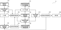
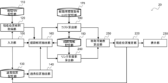
- FIG. 1 is a block diagram showing the configuration of the current position estimation device according to the embodiment of the present invention.
- the current position estimation device 10 is configured by a computer including a CPU, a RAM, and a ROM that stores a program for executing a current position estimation processing routine described later, and is functionally configured as shown below. ing.
- the current position estimation device 10 includes an input unit 100, a geographic NW storage unit 110, a current position candidate acquisition unit 120, a past position storage unit 130, and a past position extraction unit. 140, a route information storage unit 150, a route candidate extraction unit 160, a transportation unit-specific condition cost storage unit 170, a cost calculation unit 180, a transportation unit-specific transit time storage unit 190, and an estimated travel time calculation unit 200.
- the moving degree calculating unit 210, the current position estimating unit 220, and the display unit 230 are provided.
- the input unit 100 receives an input of the means of transportation and the measured position, which is the current position of the observed user.
- the input unit 100 receives the input of the transportation means via the GUI (FIG. 3) for inputting the transportation means displayed to the user of the map information survey support.
- the means of transportation are, for example, walking by a normal person, wheelchair, wheelchair with assistance, walking with a stroller, or walking with a cane.
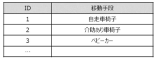
- the GUI of FIG. 3 displays the transportation list shown in FIG. 4, and the input unit 100 accepts the input of the ID corresponding to the selected transportation.
- the user can collect the positioning information while moving (when the movement history record in Fig. 3 is "on").
- the input unit 100 receives the input of the positioning position based on the positioning information regarding the current position by GPS or beacon.
- the input unit 100 passes the accepted transportation means to the route candidate extraction unit 160.
- the input unit 100 also passes the received positioning position to the current position candidate acquisition unit 120.
- the input unit 100 also receives an input of the current position on the geographic NW from the user.
- the input unit 100 stores the received current position of the user on the geographic NW in the past position storage unit 130. That is, the input of the position of the final survey point (FIG. 6) of the user on the geographic NW is accepted and stored in the past position storage unit 130 as the past position.
- the geographical NW storage unit 110 stores the geographical NW.
- the geographic NW is composed of a plurality of nodes as shown in FIG. 19 (lattice points on the left side of FIG. 19) and a plurality of links that are paths connecting the nodes.
- the current position candidate acquisition unit 120 acquires a plurality of current position candidates that are candidates for the current position on the geographic NW based on the measured position.
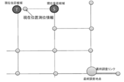
- the current position candidate acquisition unit 120 projects a point onto a link on the geographic NW near the positioning position, for example, a point on a link on the geographic NW included in the radius U [m] of the positioning position, It is acquired as a current position candidate (FIG. 5).
- the current position candidate acquisition unit 120 acquires points S and T on the geographic NW included in the radius U from the measured position as current position candidates.
- the current position candidate acquisition unit 120 passes the plurality of acquired current position candidates to the route candidate extraction unit 160.
- the past position storage unit 130 stores the past position which is the position of the user on the past geographical NW.
- the past position storage unit 130 stores the current position of the user at the time when the input unit 100 receives it as the past position. Further, the past position storage unit 130 stores the present position estimated last time by the present position estimating unit 220.
- the past position may be the position of a node on the geographic NW or the position of a point on the link.
- the past position extraction unit 140 extracts the current position on the geographic NW input by the user in the past or the current position estimated last time by the current position estimation unit 220 as the past position.
- the past position extraction unit 140 determines, from the past position storage unit 130, the position on the geographic NW at time u at which it is most certain that the user was staying immediately before reaching the current position at the current time t. Extract as past position.
- the past position extraction unit 140 extracts the past position by one of the following methods.
- the starting position is often a place where it is easy to identify the current position, such as in front of a station or in front of a specific POI.
- the user himself / herself can easily find the start position from the geographic NW, so that the survey start position can be set by himself / herself at the time of starting the survey.
- the past position extracting unit 140 extracts, as the past position, the start position at the start of the survey, out of the current user positions stored in the past position storage unit 130 by the input unit 100.
- the position of the user acquired as the survey location is stored in the past position storage unit 130, and the past position extraction unit 140 stores the position of the user at the last survey time stored in the past position storage unit 130. , As a past position.
- Previous current location acquisition point The current position estimated last time by the current position estimation unit 220 is stored in the past position storage unit 130, and the past position extraction unit 140 extracts the previous estimated current position stored in the past position storage unit 130 as the past position. To do.
- the past position extraction unit 140 passes the extracted past position to the route candidate extraction unit 160.
- the past position storage unit 130 may not be prepared, and the past position extraction unit 140 may directly extract the past position from the input unit 100 or the current position estimation unit 220.
- the route information storage unit 150 stores the geographic NW.
- accessibility information including the length of the link, the route type, and the traffic conditions for each of the plurality of links of the geographic NW is stored in association with each other (FIG. 8). ).
- the route information storage unit 150 stores the costs for each means of transportation of a plurality of links included in the geographic NW (FIG. 10).
- the cost for each link transportation means may be calculated by the cost calculation unit 180 or manually input in advance.
- the route candidate extraction unit 160 For each of the plurality of current position candidates acquired by the current position candidate acquisition unit 120, the route candidate extraction unit 160 is a route connecting the current position candidate and a past position which is a position on the past geographic NW of the user. Then, a route candidate that is a route including a link connecting each point including the current position candidate and the past position is extracted.
- the route candidate extraction unit 160 first acquires the past position of the user from the past position storage unit 130, and acquires the cost for each geographical NW and link transportation means from the route information storage unit 150.
- the route candidate extraction unit 160 excludes from the search those links whose cost included in the geographic NW is equal to or higher than a predetermined threshold Z.
- a predetermined threshold Z For example, in the example of FIG. 7, when the moving means is a wheelchair, the width of the link L4 is narrower than the moving means, and therefore the cost becomes equal to or higher than the threshold value Z. In this case, the link L4 is excluded from the search, and the route candidate is extracted.
- the route candidate extraction unit 160 extracts a plurality of route candidates that are candidates for the route to the current position candidate, starting from the past position (point on the node or link) for each of the plurality of current position candidates.
- the route search is performed using a method such as the Dijkstra method.
- the route candidate extraction unit 160 passes the plurality of extracted route candidates to the cost calculation unit 180 and the estimated movement time calculation unit 200.
- the transportation means-specific condition cost storage unit 170 stores, for each of the plurality of transportation means, a conditional cost indicating the degree of difficulty of passage of the transportation means under predetermined conditions (FIG. 9).
- a conditional cost indicating the difficulty level of the link passage for each transportation means is set in advance.
- the cost calculation unit 180 calculates, for each of the plurality of route candidates, a travel cost that indicates the degree of difficulty of traveling the route candidate by the transportation means.
- the cost calculation unit 180 first acquires the geographic NW from the route information storage unit 150 and the condition cost of the transportation means from the transportation-based condition cost storage unit 170.
- the cost calculation unit 180 calculates, for each of the plurality of route candidates, the movement cost of the route candidate by the transportation means.
- the cost calculation unit 180 calculates the movement cost of the link for each of all the links included in the route candidate based on the accessibility information and the condition cost of the link.
- the cost calculation unit 180 calculates the sum of the movement costs of all the links included in the route candidate as the movement cost of the route candidate.
- FIG. 12 shows an example of a case where the sum of travel costs of route candidates is obtained.
- conditional cost is calculated proportionally according to the distance included in the route search.
- the cost calculation unit 180 passes the calculated movement cost of the route candidate to each of the plurality of route candidates to the mobility calculation unit 210.
- the cost calculation unit 180 also stores the calculated movement cost of the route candidate in the route information storage unit 150.
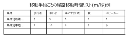
- the travel time storage unit for each travel means 190 stores the speed (m / sec) required to travel under a specific condition for each of the plurality of travel means (path travel for each travel means in FIG. 11). Time list).
- the estimated travel time calculation unit 200 calculates, for each of the plurality of route candidates, an estimated travel time of the route, which is the time required for the transportation means to pass the route candidate.
- the estimated travel time calculation unit 200 first acquires from the transit time storage unit for each travel means 190 the speed required for the travel means to travel under a specific condition.
- the estimated movement time calculation unit 200 calculates, for each of the plurality of route candidates, the estimated route movement time of each link from the route type, the length, and the acquired speed of each link of the route candidate. The sum of the estimated route movement times of the links is calculated as the estimated route movement time of the relevant route candidate (FIG. 12).
- the estimated movement time calculation unit 200 passes the estimated movement time of the route candidate to the movement possibility calculation unit 210 for each of the plurality of route candidates.
- the moveability degree calculation unit 210 calculates the movement cost calculated by the cost calculation unit 180, the estimated route movement time calculated by the estimated movement time calculation unit 200, and the past position to the current position. Based on the time required for the movement of the route candidate, the possibility of movement of the route candidate is calculated.
- the mobility calculating unit 210 for each of the plurality of route candidates, the travel cost (c) of the route candidate, the estimated route travel time (p) of the route candidate, and the past position to the current position.
- the moveability is calculated based on the time required for the movement (actual movement time) (j).
- the moveability of the route candidate is calculated.
- the mobility calculating unit 210 passes the calculated mobility of each of the plurality of route candidates to the current position estimating unit 220.
- the current position estimation unit 220 estimates the current position candidate of the route candidate having the highest mobility of the route candidate from the plurality of route candidates as the current position on the geography NW of the user.
- the current position estimation unit 220 estimates the current position candidate, which is the end point of the route candidate having the highest mobility of the route candidate, from the plurality of route candidates as the current position of the user.
- the current position estimation unit 220 stores the estimated current position of the user in the past position storage unit 130 and passes it to the display unit 230.
- the display unit 230 presents the current position to the user.
- FIG. 13 is a flowchart showing a current position estimation processing routine according to the embodiment of the present invention.
- the current position estimation device 10 executes the current position estimation processing routine shown in FIG.
- step S100 the input unit 100 receives an input of the moving means and the measured position which is the observed current position of the user.
- step S110 the current position candidate acquisition unit 120 acquires a plurality of current position candidates that are candidates for the current position on the geographic NW based on the measured position.
- step S120 the past position extraction unit 140 extracts the current position on the geographic NW input by the user in the past or the current position estimated last time by the current position estimation unit 220 as the past position.
- step S130 the route candidate extraction unit 160 determines whether there is a link whose cost included in the geographic NW is equal to or greater than a predetermined threshold Z.
- step S150 If there is no link equal to or more than the threshold Z (NO in step S130 above), the process proceeds to step S150.
- the route candidate extraction unit 160 determines in step S140 that the link cost included in the geographic NW is equal to or greater than the predetermined threshold Z, and is searched. exclude.
- step S150 the route candidate extraction unit 160 connects, for each of the plurality of current position candidates acquired in step S110, the current position candidate and a past position that is a position on the past geographic NW of the user. Then, a route candidate that is a route including a link connecting between the points including the current position candidate and the past position is extracted.
- step S160 the cost calculation unit 180 calculates, for each of the plurality of route candidates, a travel cost that indicates the degree of difficulty of traveling the route candidate by the transportation means.
- step S170 the estimated travel time calculation unit 200 calculates, for each of the plurality of route candidates, an estimated travel time of the route, which is the time required for the travel means to travel the route candidate.
- step S180 the mobility calculation unit 210, for each of the plurality of route candidates, the travel cost calculated in step S160, the estimated route movement time calculated in step S170, and the past position to the current position. Based on the time required for the movement of the route candidate, the possibility of movement of the route candidate is calculated.
- step S190 the current position estimation unit 220 estimates the current position candidate of the route candidate having the highest mobility of the route candidate from the plurality of route candidates as the current position on the geography NW of the user.
- step S200 the current position estimation unit 220 stores the current position of the user estimated in step S190 in the past position storage unit 130.
- step S210 the display unit 230 presents the current position to the user.
- a travel cost indicating the calculated difficulty level of the route candidate by the travel means and a calculation It is possible to move the route candidate based on the estimated route movement time which is the time required to pass the route candidate in the moving means and the time taken to move from the past position to the current position. It is possible to accurately estimate the current position of the user by calculating the mobility indicating the degree and estimating the current position candidate of the route candidate having the highest mobility as the current position on the geographic network of the user. it can.
- the current position estimation device 20 includes an input unit 100, a geographic NW storage unit 110, a current position candidate acquisition unit 120, a past position storage unit 130, a past position extraction unit 140, and route information.
- And a display unit 230 a display unit 230.
- the link duplication rate calculation unit 240 selects the route candidate when the movement locus obtained from the history of the measured user's positioning position is matched with the current position candidate and the past position.
- a link duplication rate is calculated, which indicates the rate at which the included links overlap with the movement locus.
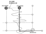
- the link duplication rate calculation unit 240 first obtains a movement locus from the time of the past position to the current time of the user from the history of the observed position of the user, and the start point and the end point of the movement locus are: Matching is performed so as to become a past position and a current position candidate (broken line in FIG. 15).
- Matching of movement locus is obtained by using, for example, map matching (curve to curve map-matching described in Reference 1).
- the link duplication rate calculation unit 240 compares the route candidate with the map matching result of the movement trajectory for each of the plurality of route candidates, and the map matching result of the movement trajectory is included in the route candidate.
- the link duplication rate which represents the rate of duplication, is calculated.
- the link duplication rate calculation unit 240 passes the calculated link duplication rate of the route candidate for each of the plurality of route candidates to the mobility calculation unit 250.
- the moveability calculating unit 250 determines the route candidate based on the moving cost calculated by the cost calculating unit 180 and the link overlapping ratio calculated by the link overlapping ratio calculating unit 240. Calculate the mobility.
- the mobility calculation unit 210 calculates the mobility for each of the plurality of route candidates by using the movement cost (c) of the route candidate and the link overlap rate (q) of the route candidate. To do.
- l and n are constants.
- the mobility calculating unit 250 passes the calculated mobility of each of the plurality of route candidates to the current position estimating unit 220.
- FIG. 16 is a flowchart showing a current position estimation processing routine according to the second embodiment of the present invention.
- the same processes as those in the current position estimation process routine according to the first embodiment are designated by the same reference numerals, and detailed description thereof will be omitted.
- step S272 the link duplication rate calculation unit 240 obtains a movement locus from the time of the past position to the current time of the user from the history of the observed position of the user, and the start point and the end point of the movement locus are the past position. Matches to become the current position candidate.
- step S274 the link duplication rate calculation unit 240 compares the route candidate with the map matching result of the movement trajectory for each of the plurality of route candidates, and the map matching result of the movement trajectory is included in the route candidate.
- a link duplication rate which represents the rate of overlapping with the link, is calculated.
- step S280 the mobility calculation unit 250 determines, for each of the plurality of route candidates, the route cost of the route candidate based on the movement cost calculated in step S160 and the link duplication rate calculated in step S274. Calculate the mobility.
- the current position estimation device for each of a plurality of route candidates, the calculated travel cost and the travel cost indicating the difficulty level of passage of the route candidate by the travel means.
- the link included in the route candidate and the link duplication rate indicating the ratio of overlapping with the movement locus.
- a travel possibility indicating the degree to which the travel route candidate can be moved is calculated, and the current position candidate of the travel route candidate having the highest travel possibility is estimated to be the current position on the geographical network of the user. By doing so, the current position of the user can be accurately estimated.
- the current position estimation device 30 includes an input unit 100, a geographic NW storage unit 110, a current position candidate acquisition unit 120, a past position storage unit 130, a past position extraction unit 140, and route information.
- Storage unit 150, route candidate extraction unit 160, transportation means-specific condition cost storage unit 170, cost calculation unit 180, transportation means-specific transit time storage unit 190, estimated travel time calculation unit 200, link overlap rate calculation A unit 240, a moveability calculation unit 260, a current position estimation unit 220, and a display unit 230 are provided.
- the moveability calculation unit 260 for each of the plurality of route candidates, the movement cost calculated by the cost calculation unit 180, the estimated route movement time calculated by the estimated movement time calculation unit 200, and the past position to the current position.
- the travel possibility is calculated based on the time required for the movement and the link duplication rate calculated by the link duplication rate calculation unit 240.
- the route candidate is a realistically movable route. 3) is used to calculate the mobility of each of the plurality of route candidates.
- l, m, and n are constants.
- FIG. 18 is a flowchart showing a current position estimation processing routine according to the third embodiment of the present invention. Note that the same reference numerals are given to the same processes as the current position estimation processing routine according to the first embodiment and the current position estimation processing routine according to the second embodiment, and detailed description thereof will be omitted.
- step S380 the movement possibility calculation unit 260, for each of the plurality of route candidates, the movement cost calculated by the cost calculation unit 180, the estimated route movement time calculated by the estimated movement time calculation unit 200, and the past position. To the current position and the link duplication rate calculated by the link duplication rate calculation unit 240, the moveability is calculated.
- the calculated travel cost and the travel cost indicating the degree of difficulty of passage of the route candidate by the travel means are estimated.
- Estimated route movement time that is the time required to pass the route candidate in the means, the time required to move from the past position to the current position, and the movement obtained from the history of the calculated observed position of the user.
- the program can be stored in a computer-readable recording medium and provided.
Landscapes
- Engineering & Computer Science (AREA)
- Radar, Positioning & Navigation (AREA)
- Remote Sensing (AREA)
- Physics & Mathematics (AREA)
- General Physics & Mathematics (AREA)
- Automation & Control Theory (AREA)
- Theoretical Computer Science (AREA)
- Mathematical Physics (AREA)
- Business, Economics & Management (AREA)
- Educational Administration (AREA)
- Educational Technology (AREA)
- Navigation (AREA)
- Instructional Devices (AREA)
Abstract
ユーザの現在位置を精度良く推定することができるようにする。 移動可能度算出部210が、複数の経路候補の各々について、算出した移動手段での当該経路候補の通行の困難度を示す移動コストと、算出した移動手段において当該経路候補を通行するために必要な時間である経路移動想定時間と、過去位置から現在位置までの移動にかかった時間とに基づいて、経路候補を移動することが可能である度合いを示す移動可能度を算出し、現在位置推定部220が、移動可能度が最も高い当該経路候補の現在位置候補を、ユーザの地理ネットワーク上の現在位置と推定する。
Description
本発明は、現在位置推定装置、現在位置推定方法、及びプログラムに関し、特に、地図情報調査においてユーザの現在位置を推定する現在位置推定装置、現在位置推定方法、及びプログラムに関する。
近年、バリアフリーが推進される中で、高齢者や車椅子など経路の通行可能条件が健常者と異なるような利用者に対しても、各利用者に適切な経路探索を行なうため、経路の通行可能条件(以下、アクセシビリティ情報)を収集する取り組みが行なわれている。
例えば、特許文献1の地図情報調査支援装置は、調査員が移動しながら地図上の地物、経路について調査を行なった調査結果を、地理NW(地理ネットワーク。例えば図19)に紐づけて記録可能にすることで、地図情報調査を支援するものである。
このような地図情報調査支援装置では、ユーザである調査員の現在位置を、そのユーザに示すことで調査を支援する必要がある。
また、調査地点の位置情報が正確である必要があり、そのためには、ユーザに調査を行っている現在位置を正確に提示する必要がある。
ユーザは経路を徒歩で移動し、調査地点を発見した際に立ち止まって調査を行うため、現在位置の提示が必要になるのは、移動中ではなく、調査対象を発見したタイミングとなる。このため、連続した現在位置の提示ではなく、一定間隔置きに立ち止まったタイミングごとの正確な現在位置の提示が必要となる。
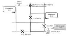
しかし、現在位置取得のための方法として測位情報(例えばGPSなど)に基づいて得られる測位位置を利用する方法があるが、測位位置をそのまま現在位置とすると、図20のように近辺の建物の影響などで誤差が生じてしまう、という問題があった。特に、高層ビルが多く立ち並ぶ場所では、実際の現在位置と測位位置とが、数mにとどまらず大きくずれることがある。
本発明は上記の点に鑑みてなされたものであり、ユーザの現在位置を精度良く推定することができる現在位置推定装置、現在位置推定方法、及びプログラムを提供することを目的とする。
本発明に係る現在位置推定装置は、移動手段と、観測されたユーザの現在位置である測位位置との入力を受け付ける入力部と、前記測位位置に基づいて、地理ネットワーク上の現在位置の候補である現在位置候補を複数取得する現在位置候補取得部と、前記現在位置候補取得部により取得された複数の前記現在位置候補の各々について、前記現在位置候補と、前記ユーザの過去の前記地理ネットワーク上の位置である過去位置とを結ぶ経路であって、前記現在位置候補と前記過去位置とを含む各地点間を結ぶリンクを含む経路である経路候補を抽出する経路候補抽出部と、前記複数の経路候補の各々について、前記移動手段での前記経路候補の通行の困難度を示す移動コストを算出するコスト算出部と、前記複数の経路候補の各々について、前記移動手段において前記経路候補を通行するために必要な時間である経路移動想定時間を算出する移動想定時間算出部と、前記複数の経路候補の各々について、前記コスト算出部により算出された前記移動コストと、前記移動想定時間算出部により算出された前記経路移動想定時間と、前記過去位置から前記現在位置までの移動にかかった時間とに基づいて、前記経路候補を移動することが可能である度合いを示す移動可能度を算出する移動可能度算出部と、前記複数の経路候補から、前記経路候補の前記移動可能度が最も高い前記経路候補の前記現在位置候補を、前記ユーザの前記地理ネットワーク上の現在位置と推定する現在位置推定部と、を備えて構成される。
また、本発明に係る現在位置推定方法は、入力部が、移動手段と、観測されたユーザの現在位置である測位位置との入力を受け付け、現在位置候補取得部が、前記測位位置に基づいて、地理ネットワーク上の現在位置の候補である現在位置候補を複数取得し、経路候補抽出部が、前記現在位置候補取得部により取得された複数の前記現在位置候補の各々について、前記現在位置候補と、前記ユーザの過去の前記地理ネットワーク上の位置である過去位置とを結ぶ経路であって、前記現在位置候補と前記過去位置とを含む各地点間を結ぶリンクを含む経路である経路候補を抽出し、コスト算出部が、前記複数の経路候補の各々について、前記移動手段での前記経路候補の通行の困難度を示す移動コストを算出し、移動想定時間算出部が、前記複数の経路候補の各々について、前記移動手段において前記経路候補を通行するために必要な時間である経路移動想定時間を算出し、移動可能度算出部が、前記複数の経路候補の各々について、前記コスト算出部により算出された前記移動コストと、前記移動想定時間算出部により算出された前記経路移動想定時間と、前記過去位置から前記現在位置までの移動にかかった時間とに基づいて、前記経路候補を移動することが可能である度合いを示す移動可能度を算出し、現在位置推定部が、前記複数の経路候補から、前記経路候補の前記移動可能度が最も高い前記経路候補の前記現在位置候補を、前記ユーザの前記地理ネットワーク上の現在位置と推定する。
本発明に係る現在位置推定装置及び現在位置推定方法によれば、入力部が、移動手段と、観測されたユーザの現在位置である測位位置との入力を受け付け、現在位置候補取得部が、測位位置に基づいて、地理ネットワーク上の現在位置の候補である現在位置候補を複数取得し、経路候補抽出部が、現在位置候補取得部により取得された複数の現在位置候補の各々について、当該現在位置候補と、ユーザの過去の地理ネットワーク上の位置である過去位置とを結ぶ経路であって、当該現在位置候補と過去位置とを含む各地点間を結ぶリンクを含む経路である経路候補を抽出する。
そして、コスト算出部が、複数の経路候補の各々について、移動手段での当該経路候補の通行の困難度を示す移動コストを算出し、移動想定時間算出部が、複数の経路候補の各々について、移動手段において当該経路候補を通行するために必要な時間である経路移動想定時間を算出し、移動可能度算出部が、複数の経路候補の各々について、コスト算出部により算出された移動コストと、移動想定時間算出部により算出された経路移動想定時間と、過去位置から現在位置までの移動にかかった時間とに基づいて、経路候補を移動することが可能である度合いを示す移動可能度を算出し、現在位置推定部が、複数の経路候補から、当該経路候補の移動可能度が最も高い当該経路候補の現在位置候補を、ユーザの地理ネットワーク上の現在位置と推定する。
このように、複数の経路候補の各々について、算出した移動手段での当該経路候補の通行の困難度を示す移動コストと、算出した移動手段において当該経路候補を通行するために必要な時間である経路移動想定時間と、過去位置から現在位置までの移動にかかった時間とに基づいて、経路候補を移動することが可能である度合いを示す移動可能度を算出し、移動可能度が最も高い当該経路候補の現在位置候補を、ユーザの地理ネットワーク上の現在位置と推定することにより、ユーザの現在位置を精度良く推定することができる。
また、本発明に係る現在位置推定装置は、前記複数の経路候補の各々について、前記観測されたユーザの測位位置の履歴から求められる移動軌跡を、前記現在位置候補と前記過去位置とにマッチングさせた際に、前記経路候補に含まれるリンクが、前記移動軌跡と重複する割合を表すリンク重複率を算出するリンク重複率算出部を更に含み、前記移動可能度算出部は、前記コスト算出部により算出された前記移動コストと、前記移動想定時間算出部により算出された前記経路移動想定時間と、前記過去位置から前記現在位置までの移動にかかった時間と、前記リンク重複率算出部により算出された前記リンク重複率とに基づいて、前記移動可能度を算出することができる。
本発明に係る現在位置推定装置は、移動手段と、観測されたユーザの現在位置である測位位置との入力を受け付ける入力部と、前記測位位置に基づいて、地理ネットワーク上の現在位置の候補である現在位置候補を複数取得する現在位置候補取得部と、前記現在位置候補取得部により取得された複数の前記現在位置候補の各々について、前記現在位置候補と、前記ユーザの過去の前記地理ネットワーク上の位置である過去位置とを結ぶ経路であって、前記現在位置候補と前記過去位置とを含む各地点間を結ぶリンクを含む経路である経路候補を抽出する経路候補抽出部と、前記複数の経路候補の各々について、前記移動手段での前記経路候補の通行の困難度を示す移動コストを算出するコスト算出部と、前記複数の経路候補の各々について、前記観測されたユーザの測位位置の履歴から求められる移動軌跡を、前記現在位置候補と前記過去位置とにマッチングさせた際に、前記経路候補に含まれるリンクが、前記移動軌跡と重複する割合を表すリンク重複率を算出するリンク重複率算出部と、複数の経路候補の各々について、前記コスト算出部により算出された前記移動コストと、前記リンク重複率算出部により算出された前記リンク重複率とに基づいて、前記経路候補を移動することが可能である度合いを示す移動可能度を算出する移動可能度算出部と、前記複数の経路候補から、前記経路候補の前記移動可能度が最も高い前記経路候補の前記現在位置候補を、前記ユーザの前記地理ネットワーク上の現在位置と推定する現在位置推定部と、を備えて構成される。
また、本発明に係る現在位置推定方法は、入力部が、移動手段と、観測されたユーザの現在位置である測位位置との入力を受け付け、現在位置候補取得部が、前記測位位置に基づいて、地理ネットワーク上の現在位置の候補である現在位置候補を複数取得し、経路候補抽出部が、前記現在位置候補取得部により取得された複数の前記現在位置候補の各々について、前記現在位置候補と、前記ユーザの過去の前記地理ネットワーク上の位置である過去位置とを結ぶ経路であって、前記現在位置候補と前記過去位置とを含む各地点間を結ぶリンクを含む経路である経路候補を抽出し、コスト算出部が、前記複数の経路候補の各々について、前記移動手段での前記経路候補の通行の困難度を示す移動コストを算出し、リンク重複率算出部が、前記複数の経路候補の各々について、前記観測されたユーザの測位位置の履歴から求められる移動軌跡を、前記現在位置候補と前記過去位置とにマッチングさせた際に、前記経路候補に含まれるリンクが、前記移動軌跡と重複する割合を表すリンク重複率を算出し、移動可能度算出部が、前記コスト算出部により算出された前記移動コストと、前記リンク重複率算出部により算出された前記リンク重複率とに基づいて、前記経路候補を移動することが可能である度合いを示す移動可能度を算出し、現在位置推定部が、前記複数の経路候補から、前記経路候補の前記移動可能度が最も高い前記経路候補の前記現在位置候補を、前記ユーザの前記地理ネットワーク上の現在位置と推定する。
本発明に係る現在位置推定装置及び現在位置推定方法によれば、入力部が、移動手段と、観測されたユーザの現在位置である測位位置との入力を受け付け、現在位置候補取得部が、測位位置に基づいて、地理ネットワーク上の現在位置の候補である現在位置候補を複数取得し、経路候補抽出部が、現在位置候補取得部により取得された複数の現在位置候補の各々について、当該現在位置候補と、ユーザの過去の地理ネットワーク上の位置である過去位置とを結ぶ経路であって、当該現在位置候補と過去位置とを含む各地点間を結ぶリンクを含む経路である経路候補を抽出する。
そして、コスト算出部が、複数の経路候補の各々について、移動手段での当該経路候補の通行の困難度を示す移動コストを算出し、リンク重複率算出部が、複数の経路候補の各々について、観測されたユーザの測位位置の履歴から求められる移動軌跡を、現在位置候補と過去位置とにマッチングさせた際に、当該経路候補に含まれるリンクが、移動軌跡と重複する割合を表すリンク重複率を算出し、移動可能度算出部が、複数の経路候補の各々について、コスト算出部により算出された移動コストと、リンク重複率算出部により算出された前記リンク重複率とに基づいて、経路候補を移動することが可能である度合いを示す移動可能度を算出し、現在位置推定部が、複数の経路候補から、当該経路候補の移動可能度が最も高い当該経路候補の現在位置候補を、ユーザの地理ネットワーク上の現在位置と推定する。
このように、複数の経路候補の各々について、算出した移動手段での当該経路候補の通行の困難度を示す移動コストと、算出した観測されたユーザの測位位置の履歴から求められる移動軌跡を、現在位置候補と過去位置とにマッチングさせた際に、当該経路候補に含まれるリンクが、移動軌跡と重複する割合を表すリンク重複率とに基づいて、当該経路候補を移動することが可能である度合いを示す移動可能度を算出し、移動可能度が最も高い当該経路候補の現在位置候補を、ユーザの地理ネットワーク上の現在位置と推定することにより、ユーザの現在位置を精度良く推定することができる。
また、本発明に係る現在位置推定装置は、前記ユーザから過去に入力された前記地理ネットワーク上の現在位置、又は前記現在位置推定部により前回推定された前記現在位置を、前記過去位置として抽出する過去位置抽出部を更に含むことができる。
また、本発明に係る現在位置推定装置の前記コスト算出部は、前記経路候補抽出部により抽出された複数の経路候補の各々について、前記経路候補に含まれるリンクのアクセシビリティ情報に基づいて前記移動手段についてリンク毎に求められた通行の困難度を示すコストに基づいて、前記移動コストを算出することができる。
本発明に係るプログラムは、コンピュータを、上記の現在位置推定装置の各部として機能させるためのプログラムである。
本発明の現在位置推定装置、現在位置推定方法、及びプログラムによれば、ユーザの現在位置を精度良く推定することができる。
以下、本発明の実施の形態について図面を用いて説明する。
<本発明の実施の形態に係る現在位置推定装置の概要>
まず、本発明の実施形態の概要について説明する。
まず、本発明の実施形態の概要について説明する。
本実施形態に係る現在位置推定装置は、地図情報調査支援(または地図表示)において、ユーザの移動手段と、測位情報及び地理NW(ネットワーク)に紐づくアクセシビリティ情報とを利用して、ユーザ(調査員)の現在位置を推定する。
ユーザの移動手段及びアクセシビリティ情報から、ユーザの現在位置候補の各々までの経路候補を抽出し、抽出した経路候補の各々について、移動手段に応じた当該経路候補を通行する困難度を示す移動コスト、及び当該経路候補を移動するために必要であると想定される時間(移動想定時間)を推定し、推定結果から、現実的に移動可能であり、かつ、最も移動コストが少ない現在位置候補を、ユーザの現在位置と推定する。
例えば、図2に示すように、GPS等の測位情報に基づく測位位置と、地理NW上の現在位置との間に誤差がある場合には、ユーザの現在位置の候補が複数存在するため、各現在位置候補までの経路の移動想定時間を推定し、推定結果から現実的に移動可能であり、かつ最も移動コストが少ない現在位置候補を現在位置と推定する。移動手段が車いすの場合には、階段や幅員が50cmのリンクは移動することができないため、当該移動手段により移動することができないリンクが含まれる経路は除外されることとなる。
このような構成により、測位情報以外の情報によって測位誤差を補完することができるため、ユーザの位置を正確に推測することが可能となる。
<本発明の第1の実施の形態に係る現在位置推定装置の構成>
図1を参照して、本発明の実施の形態に係る現在位置推定装置の構成について説明する。図1は、本発明の実施の形態に係る現在位置推定装置の構成を示すブロック図である。
図1を参照して、本発明の実施の形態に係る現在位置推定装置の構成について説明する。図1は、本発明の実施の形態に係る現在位置推定装置の構成を示すブロック図である。
現在位置推定装置10は、CPUと、RAMと、後述する現在位置推定処理ルーチンを実行するためのプログラムを記憶したROMとを備えたコンピュータで構成され、機能的には次に示すように構成されている。
図1に示すように、本実施形態に係る現在位置推定装置10は、入力部100と、地理NW記憶部110と、現在位置候補取得部120と、過去位置記憶部130と、過去位置抽出部140と、経路情報記憶部150と、経路候補抽出部160と、移動手段別条件コスト記憶部170と、コスト算出部180と、移動手段別通行時間記憶部190と、移動想定時間算出部200と、移動可能度算出部210と、現在位置推定部220と、表示部230とを備えて構成される。
入力部100は、移動手段と、観測されたユーザの現在位置である測位位置との入力を受け付ける。
具体的には、入力部100は、地図情報調査支援のユーザに対して表示された移動手段を入力するGUI(図3)を経由して、移動手段の入力を受け付ける。
移動手段は、例えば、健常者による歩行、車椅子、介助ありの車椅子、ベビーカーを所持した歩行、又は杖を用いた歩行がある。例えば、図3のGUIでは、図4に示す移動手段リストを表示し、入力部100は、選択された移動手段に対応するIDの入力を受け付ける。
さらに、測位情報の取得に関する設定を行うことで、ユーザが移動中の測位情報を収集できるようにする(図3の移動履歴記録が“on”の場合)。
また、入力部100は、GPSやビーコン等による現在位置に関する測位情報に基づく測位位置の入力を受け付ける。
そして、入力部100は、受け付けた移動手段を経路候補抽出部160に渡す。また、入力部100は、受け付けた測位位置を、現在位置候補取得部120に渡す。
また、入力部100は、ユーザから地理NW上の現在位置の入力を受け付ける。
そして、入力部100は、受け付けたユーザの地理NW上の現在位置を、過去位置記憶部130に格納する。すなわち、地理NW上のユーザの最終調査地点の位置(図6)の入力を受け付け、過去位置記憶部130に過去位置として格納しておく。
地理NW記憶部110には、地理NWが格納されている。
具体的には、地理NWは、図19に示すような複数のノード(図19左の格子点)と、ノード間を結ぶ経路である複数のリンクとから構成される。
現在位置候補取得部120は、測位位置に基づいて、地理NW上の現在位置の候補である現在位置候補を複数取得する。
具体的には、現在位置候補取得部120は、測位位置の近傍の地理NW上のリンク、例えば測位位置の半径U[m]に含まれる地理NW上のリンクへの射影を行った点を、現在位置候補として取得する(図5)。
図5の例では、現在位置候補取得部120は、測位位置から半径Uに含まれる地理NW上の点S及びTを、現在位置候補として取得する。
そして、現在位置候補取得部120は、取得した複数の現在位置候補を、経路候補抽出部160に渡す。
過去位置記憶部130には、ユーザの過去の地理NW上の位置である過去位置が格納されている。
具体的には、過去位置記憶部130には、入力部100が受け付けた時点のユーザの現在位置が、過去位置として格納されている。また、過去位置記憶部130には、現在位置推定部220により前回推定された現在位置が格納される。なお、過去位置は、地理NW上のノードの位置であってもリンク上の点の位置であってもよい。
過去位置抽出部140は、ユーザから過去に入力された地理NW上の現在位置、又は現在位置推定部220により前回推定された現在位置を、過去位置として抽出する。
具体的には、過去位置抽出部140は、過去位置記憶部130から、現在の時刻tにおける現在位置に至る直前にユーザが滞在していたことが最も確からしい時刻uの地理NW上の位置を過去位置として抽出する。
例えば、過去位置抽出部140は、以下のような方法のいずれかで過去位置を抽出する。
<<調査の開始位置を利用者が入力>>
調査の開始時刻である時刻uの地理NW上の位置をユーザ自身に設定させる。
調査の開始時刻である時刻uの地理NW上の位置をユーザ自身に設定させる。
例えば、イベント的にユーザが集合して調査を開始する場合、駅前や特定POIの前など現在位置を特定しやすい場所が開始位置となることが多い。そのような場合は、開始位置をユーザ自身が地理NW上から発見することも容易であるため、調査開始時に調査開始位置を自身で設定することが可能である。
この場合、過去位置抽出部140は、入力部100により過去位置記憶部130に格納されたユーザの現在位置のうち、調査開始時の開始位置を、過去位置として抽出する。
<<現時刻における最後の調査地点の取得>>
調査は現地で目視して行われ、その際に、調査地点が入力されることから、現時刻tにおける最後の調査地点を、現時刻t以前の最後の滞在地点と考えることができる。そこで、現時刻tにおける最後の調査時刻である時刻uに入力された地理NW上のユーザの位置を取得する。
調査は現地で目視して行われ、その際に、調査地点が入力されることから、現時刻tにおける最後の調査地点を、現時刻t以前の最後の滞在地点と考えることができる。そこで、現時刻tにおける最後の調査時刻である時刻uに入力された地理NW上のユーザの位置を取得する。
この場合、調査地点として取得されたユーザの位置を過去位置記憶部130に格納しておき、過去位置抽出部140は、過去位置記憶部130に格納されている最後の調査時刻のユーザの位置を、過去位置として抽出する。
<<前回現在位置取得地点>>
現在位置推定部220により前回推定された現在位置が過去位置記憶部130に格納され、過去位置抽出部140は、過去位置記憶部130に格納されている前回推定された現在位置を過去位置として抽出する。
現在位置推定部220により前回推定された現在位置が過去位置記憶部130に格納され、過去位置抽出部140は、過去位置記憶部130に格納されている前回推定された現在位置を過去位置として抽出する。
そして、過去位置抽出部140は、抽出した過去位置を、経路候補抽出部160に渡す。
なお、過去位置記憶部130を用意せず、直接過去位置抽出部140が入力部100又は現在位置推定部220から過去位置を抽出する構成としてもよい。
経路情報記憶部150には、地理NW記憶部110と同様に、地理NWが格納されている。また、経路情報記憶部150の地理NWには、当該地理NWの複数のリンクの各々についての当該リンクの長さ、経路種別及び通行条件を含むアクセシビリティ情報が紐づけて格納されている(図8)。
また、経路情報記憶部150には、地理NWに含まれる複数のリンクの移動手段ごとのコストが格納されている(図10)。リンクの移動手段ごとのコストは、コスト算出部180により算出されたものでも、予め人手により入力されたものでもよい。
経路候補抽出部160は、現在位置候補取得部120により取得された複数の現在位置候補の各々について、当該現在位置候補と、ユーザの過去の地理NW上の位置である過去位置とを結ぶ経路であって、当該現在位置候補と当該過去位置とを含む各地点間を結ぶリンクを含む経路である経路候補を抽出する。
具体的には、経路候補抽出部160は、まず、過去位置記憶部130から、ユーザの過去位置を取得し、経路情報記憶部150から地理NW及びリンクの移動手段ごとのコストを取得する。
次に、経路候補抽出部160は、地理NW上に含まれるリンクのコストが予め定めた閾値Z以上のリンクについては、探索から除外する。例えば、図7の例では、移動手段が車いすであった場合にリンクL4の幅員が当該移動手段に対して狭いため、コストが閾値Z以上となる。この場合に、リンクL4については探索から除外して、経路候補を抽出する。
経路候補抽出部160は、複数の現在位置候補の各々について、過去位置(ノード又はリンク上の点)を始点とし、当該現在位置候補までの経路の候補である経路候補を複数抽出する。なお、経路探索は、例えばダイクストラ法等の手法を用いて行う。
そして、経路候補抽出部160は、抽出した複数の経路候補を、コスト算出部180及び移動想定時間算出部200に渡す。
移動手段別条件コスト記憶部170には、複数の移動手段の各々について、所定の条件下における当該移動手段の通行の困難度を示す条件コストが格納されている(図9)。
具体的には、地理NWに含まれる複数のリンクの各々について、移動手段ごとの当該リンク通行の困難度を示す条件コストが予め設定される。
コスト算出部180は、複数の経路候補の各々について、当該移動手段での当該経路候補の通行の困難度を示す移動コストを算出する。
具体的には、コスト算出部180は、まず、経路情報記憶部150から地理NWと、移動手段別条件コスト記憶部170から当該移動手段における条件コストとを取得する。
次に、コスト算出部180は、複数の経路候補の各々について、当該移動手段での当該経路候補の移動コストを算出する。コスト算出部180は、当該経路候補に含まれる全てのリンクの各々について、当該リンクの移動コストを、当該リンクのアクセシビリティ情報と条件コストとに基づいて算出する。
そして、コスト算出部180は、当該経路候補に含まれる全てのリンクの移動コストの和を、当該経路候補の移動コストとして算出する。図12に、経路候補の移動コストの和を求めた場合の例を示す。
なお、過去地点及び現在位置候補がリンクの途中である場合には、条件コストは経路探索に含まれる距離に応じた比例計算を行う。
そして、コスト算出部180は、複数の経路候補の各々について、算出した当該経路候補の移動コストを、移動可能度算出部210に渡す。また、コスト算出部180は、算出した当該経路候補の移動コストを、経路情報記憶部150に格納する。
移動手段別通行時間記憶部190には、複数の移動手段の各々について、特定の条件を通行するために必要な速度(m/秒)が格納されている(図11の移動手段ごとの経路移動時間リスト)。
移動想定時間算出部200は、複数の経路候補の各々について、当該移動手段において当該経路候補を通行するために必要な時間である経路移動想定時間を算出する。
具体的には、移動想定時間算出部200は、まず、移動手段別通行時間記憶部190から、当該移動手段により特定の条件を通行するために必要な速度を取得する。
次に、移動想定時間算出部200は、複数の経路候補の各々について、当該経路候補の各リンクの経路種別、長さ、及び取得した速度から、各リンクの経路移動想定時間を算出し、各リンクの経路移動想定時間の和を、当該経路候補の経路移動想定時間として算出する(図12)。
そして、移動想定時間算出部200は、複数の経路候補の各々について、当該経路候補の経路移動想定時間を、移動可能度算出部210に渡す。
移動可能度算出部210は、複数の経路候補の各々について、コスト算出部180により算出された移動コストと、移動想定時間算出部200により算出された経路移動想定時間と、過去位置から現在位置までの移動にかかった時間とに基づいて、当該経路候補を移動することが可能である度合いを示す移動可能度を算出する。
具体的には、移動可能度算出部210は、複数の経路候補の各々について、当該経路候補の移動コスト(c)、当該経路候補の経路移動想定時間(p)と、過去位置から現在位置までの移動にかかった時間(実際の移動時間)(j)とに基づいて、移動可能度を算出する。
ここで、移動コストが高いほど当該経路候補が移動困難な経路である可能性が高く、現実的な経路でないと想定されるため、低い方がよい。
また、実際の移動時間と経路移動想定時間の差分が小さいほど、実際の移動環境に近いと推定される。
よって、移動コストと、実際の移動時間及び経路移動想定時間の差分とが共に低くなるものほど、現実的に移動可能な経路候補であると想定されるため、下記式(1)を用いて複数の経路候補の各々について、当該経路候補の移動可能度を算出する。

ここで、l及びmは定数である。
そして、移動可能度算出部210は、算出した複数の経路候補の各々についての当該経路候補の移動可能度を現在位置推定部220に渡す。
現在位置推定部220は、複数の経路候補から、当該経路候補の移動可能度が最も高い当該経路候補の現在位置候補を、ユーザの地理NW上の現在位置と推定する。
具体的には、現在位置推定部220は、複数の経路候補から、当該経路候補の移動可能度が最も高くなる経路候補の終点となる現在地候補をユーザの現在位置であると推定する。
そして、現在位置推定部220は、推定したユーザの現在位置を、過去位置記憶部130に格納すると共に、表示部230に渡す。
表示部230は、現在位置をユーザに提示する。
<本発明の第1の実施の形態に係る現在位置推定装置の作用>
図13は、本発明の実施の形態に係る現在位置推定処理ルーチンを示すフローチャートである。
図13は、本発明の実施の形態に係る現在位置推定処理ルーチンを示すフローチャートである。
入力部100に移動手段及び測位位置が入力されると、現在位置推定装置10において、図13に示す現在位置推定処理ルーチンが実行される。
まず、ステップS100において、入力部100は、移動手段と、観測されたユーザの現在位置である測位位置との入力を受け付ける。
ステップS110において、現在位置候補取得部120は、測位位置に基づいて、地理NW上の現在位置の候補である現在位置候補を複数取得する。
ステップS120において、過去位置抽出部140は、ユーザから過去に入力された地理NW上の現在位置、又は現在位置推定部220により前回推定された現在位置を、過去位置として抽出する。
ステップS130において、経路候補抽出部160は、地理NW上に含まれるリンクのコストが予め定めた閾値Z以上のリンクがあるか否かを判定する。
閾値Z以上のリンクが無い場合(上記ステップS130のNO)、ステップS150に進む。
閾値Z以上のリンクがある場合(上記ステップS130のYES)、ステップS140において、経路候補抽出部160は、地理NW上に含まれるリンクのコストが予め定めた閾値Z以上のリンクについては、探索から除外する。
ステップS150において、経路候補抽出部160は、上記ステップS110により取得された複数の現在位置候補の各々について、当該現在位置候補と、ユーザの過去の地理NW上の位置である過去位置とを結ぶ経路であって、当該現在位置候補と当該過去位置とを含む各地点間を結ぶリンクを含む経路である経路候補を抽出する。
ステップS160において、コスト算出部180は、複数の経路候補の各々について、当該移動手段での当該経路候補の通行の困難度を示す移動コストを算出する。
ステップS170において、移動想定時間算出部200は、複数の経路候補の各々について、当該移動手段において当該経路候補を通行するために必要な時間である経路移動想定時間を算出する。
ステップS180において、移動可能度算出部210は、複数の経路候補の各々について、上記ステップS160により算出された移動コストと、上記ステップS170により算出された経路移動想定時間と、過去位置から現在位置までの移動にかかった時間とに基づいて、当該経路候補を移動することが可能である度合いを示す移動可能度を算出する。
ステップS190において、現在位置推定部220は、複数の経路候補から、当該経路候補の移動可能度が最も高い当該経路候補の現在位置候補を、ユーザの地理NW上の現在位置と推定する。
ステップS200において、現在位置推定部220は、上記ステップS190により推定されたユーザの現在位置を、過去位置記憶部130に格納する。
ステップS210において、表示部230は、現在位置をユーザに提示する。
以上説明したように、本発明の実施形態に係る現在位置推定装置によれば、複数の経路候補の各々について、算出した移動手段での当該経路候補の通行の困難度を示す移動コストと、算出した移動手段において当該経路候補を通行するために必要な時間である経路移動想定時間と、過去位置から現在位置までの移動にかかった時間とに基づいて、経路候補を移動することが可能である度合いを示す移動可能度を算出し、移動可能度が最も高い当該経路候補の現在位置候補を、ユーザの地理ネットワーク上の現在位置と推定することにより、ユーザの現在位置を精度良く推定することができる。
<本発明の第2の実施の形態に係る現在位置推定装置の構成>
本発明の第2の実施の形態に係る現在位置推定装置20の構成について説明する。なお、第1の実施の形態に係る現在位置推定装置10と同様の構成については、同一の符号を付して詳細な説明は省略する。
本発明の第2の実施の形態に係る現在位置推定装置20の構成について説明する。なお、第1の実施の形態に係る現在位置推定装置10と同様の構成については、同一の符号を付して詳細な説明は省略する。
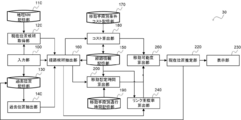
図14に示すように、現在位置推定装置20は、入力部100と、地理NW記憶部110と、現在位置候補取得部120と、過去位置記憶部130と、過去位置抽出部140と、経路情報記憶部150と、経路候補抽出部160と、移動手段別条件コスト記憶部170と、コスト算出部180と、リンク重複率算出部240と、移動可能度算出部250と、現在位置推定部220と、表示部230とを備えて構成される。
リンク重複率算出部240は、複数の経路候補の各々について、観測されたユーザの測位位置の履歴から求められる移動軌跡を、現在位置候補と過去位置とにマッチングさせた際に、前記経路候補に含まれるリンクが、前記移動軌跡と重複する割合を表すリンク重複率を算出する。
具体的には、リンク重複率算出部240は、まず、観測されたユーザの測位位置の履歴から、過去位置の時点からユーザの現在時点までの移動軌跡を求め、移動軌跡の始点及び終点が、過去位置と現在位置候補となるようにマッチングさせる(図15の破線)。
移動軌跡のマッチングは、例えばマップマッチング(参考文献1記載のcurve to curve map-matching等)を用いて求める。
[参考文献1]羽藤英二、外2名、“マップマッチングのアルゴリズム”、[online]、2014年、[2018年8月30日検索]、インターネット<URL:http://bin.t.u-tokyo.ac.jp/startup15/file/0529yamamoto.pdf>。
次に、リンク重複率算出部240は、複数の経路候補の各々について、当該経路候補と、移動軌跡のマップマッチング結果とを比較し、移動軌跡のマップマッチング結果が、当該経路候補に含まれるリンクと重複する割合を表すリンク重複率を算出する。
そして、リンク重複率算出部240は、複数の経路候補の各々について、算出した当該経路候補のリンク重複率を、移動可能度算出部250に渡す。
移動可能度算出部250は、複数の経路候補の各々について、コスト算出部180により算出された移動コストと、リンク重複率算出部240により算出されたリンク重複率とに基づいて、当該経路候補の移動可能度を算出する。
具体的には、移動可能度算出部210は、複数の経路候補の各々について、当該経路候補の移動コスト(c)と、当該経路候補のリンク重複率(q)を用いて移動可能度を算出する。
ここで、経路候補のリンク重複率が高いほど、実際に当該経路候補を通過している可能性が高い。
よって、移動コストが低く、かつ、リンク重複率が高いものほど、現実的に移動可能な経路候補であると想定されるため、下記式(2)を用いて複数の経路候補の各々について、当該経路候補の移動可能度を算出する。

ここで、l及びnは定数である。
そして、移動可能度算出部250は、算出した複数の経路候補の各々についての当該経路候補の移動可能度を現在位置推定部220に渡す。
<本発明の第2の実施の形態に係る現在位置推定装置の作用>
図16は、本発明の第2の実施の形態に係る現在位置推定処理ルーチンを示すフローチャートである。なお、第1の実施の形態に係る現在位置推定処理ルーチンと同様の処理については、同一の符号を付して詳細な説明は省略する。
図16は、本発明の第2の実施の形態に係る現在位置推定処理ルーチンを示すフローチャートである。なお、第1の実施の形態に係る現在位置推定処理ルーチンと同様の処理については、同一の符号を付して詳細な説明は省略する。
ステップS272において、リンク重複率算出部240は、観測されたユーザの測位位置の履歴から、過去位置の時点からユーザの現在時点までの移動軌跡を求め、移動軌跡の始点及び終点が、過去位置と現在位置候補となるようにマッチングさせる。
ステップS274において、リンク重複率算出部240は、複数の経路候補の各々について、当該経路候補と、移動軌跡のマップマッチング結果とを比較し、移動軌跡のマップマッチング結果が、当該経路候補に含まれるリンクと重複する割合を表すリンク重複率を算出する。
ステップS280において、移動可能度算出部250は、複数の経路候補の各々について、上記ステップS160により算出された移動コストと、上記ステップS274により算出されたリンク重複率とに基づいて、当該経路候補の移動可能度を算出する。
以上説明したように、本実施形態に係る現在位置推定装置によれば、複数の経路候補の各々について、算出した移動手段での当該経路候補の通行の困難度を示す移動コストと、算出した観測されたユーザの測位位置の履歴から求められる移動軌跡を、現在位置候補と過去位置とにマッチングさせた際に、当該経路候補に含まれるリンクが、移動軌跡と重複する割合を表すリンク重複率とに基づいて、当該経路候補を移動することが可能である度合いを示す移動可能度を算出し、移動可能度が最も高い当該経路候補の現在位置候補を、ユーザの地理ネットワーク上の現在位置と推定することにより、ユーザの現在位置を精度良く推定することができる。
<本発明の第3の実施の形態に係る現在位置推定装置の構成>
本発明の第3の実施の形態に係る現在位置推定装置30の構成について説明する。なお、第1の実施の形態に係る現在位置推定装置10、第2の実施の形態に係る現在位置推定装置20と同様の構成については、同一の符号を付して詳細な説明は省略する。
本発明の第3の実施の形態に係る現在位置推定装置30の構成について説明する。なお、第1の実施の形態に係る現在位置推定装置10、第2の実施の形態に係る現在位置推定装置20と同様の構成については、同一の符号を付して詳細な説明は省略する。
図17に示すように、現在位置推定装置30は、入力部100と、地理NW記憶部110と、現在位置候補取得部120と、過去位置記憶部130と、過去位置抽出部140と、経路情報記憶部150と、経路候補抽出部160と、移動手段別条件コスト記憶部170と、コスト算出部180と、移動手段別通行時間記憶部190と、移動想定時間算出部200と、リンク重複率算出部240と、移動可能度算出部260と、現在位置推定部220と、表示部230とを備えて構成される。
移動可能度算出部260は、複数の経路候補の各々について、コスト算出部180により算出された移動コストと、移動想定時間算出部200により算出された経路移動想定時間と、過去位置から現在位置までの移動にかかった時間と、リンク重複率算出部240により算出されたリンク重複率とに基づいて、移動可能度を算出する。
移動コストと、実際の移動時間及び経路移動想定時間の差分とが共に低くなり、かつ、リンク重複率が高いものほど、現実的に移動可能な経路候補であると想定されるため、下記式(3)を用いて複数の経路候補の各々について、当該経路候補の移動可能度を算出する。

ここで、l、m、及びnは定数である。
<本発明の第3の実施の形態に係る現在位置推定装置の作用>
図18は、本発明の第3の実施の形態に係る現在位置推定処理ルーチンを示すフローチャートである。なお、第1の実施の形態に係る現在位置推定処理ルーチン及び第2の実施の形態に係る現在位置推定処理ルーチンと同様の処理については、同一の符号を付して詳細な説明は省略する。
図18は、本発明の第3の実施の形態に係る現在位置推定処理ルーチンを示すフローチャートである。なお、第1の実施の形態に係る現在位置推定処理ルーチン及び第2の実施の形態に係る現在位置推定処理ルーチンと同様の処理については、同一の符号を付して詳細な説明は省略する。
ステップS380において、移動可能度算出部260は、複数の経路候補の各々について、コスト算出部180により算出された移動コストと、移動想定時間算出部200により算出された経路移動想定時間と、過去位置から現在位置までの移動にかかった時間と、リンク重複率算出部240により算出されたリンク重複率とに基づいて、移動可能度を算出する。
以上説明したように、本実施形態に係る現在位置推定装置によれば、複数の経路候補の各々について、算出した移動手段での当該経路候補の通行の困難度を示す移動コストと、算出した移動手段において当該経路候補を通行するために必要な時間である経路移動想定時間と、過去位置から現在位置までの移動にかかった時間と、算出した観測されたユーザの測位位置の履歴から求められる移動軌跡を、現在位置候補と過去位置とにマッチングさせた際に、当該経路候補に含まれるリンクが、移動軌跡と重複する割合を表すリンク重複率とに基づいて、経路候補を移動することが可能である度合いを示す移動可能度を算出し、移動可能度が最も高い当該経路候補の現在位置候補を、ユーザの地理ネットワーク上の現在位置と推定することにより、ユーザの現在位置を精度良く推定することができる。
なお、本発明は、上述した実施の形態に限定されるものではなく、この発明の要旨を逸脱しない範囲内で様々な変形や応用が可能である。
また、本願明細書中において、プログラムが予めインストールされている実施形態として説明したが、当該プログラムを、コンピュータ読み取り可能な記録媒体に格納して提供することも可能である。
10 現在位置推定装置
20 現在位置推定装置
30 現在位置推定装置
100 入力部
110 記憶部
120 現在位置候補取得部
130 過去位置記憶部
140 過去位置抽出部
150 経路情報記憶部
160 経路候補抽出部
170 移動手段別条件コスト記憶部
180 コスト算出部
190 移動手段別通行時間記憶部
200 移動想定時間算出部
210 移動可能度算出部
220 現在位置推定部
230 表示部
240 リンク重複率算出部
250 移動可能度算出部
260 移動可能度算出部
20 現在位置推定装置
30 現在位置推定装置
100 入力部
110 記憶部
120 現在位置候補取得部
130 過去位置記憶部
140 過去位置抽出部
150 経路情報記憶部
160 経路候補抽出部
170 移動手段別条件コスト記憶部
180 コスト算出部
190 移動手段別通行時間記憶部
200 移動想定時間算出部
210 移動可能度算出部
220 現在位置推定部
230 表示部
240 リンク重複率算出部
250 移動可能度算出部
260 移動可能度算出部
Claims (8)
- 移動手段と、観測されたユーザの現在位置である測位位置との入力を受け付ける入力部と、
前記測位位置に基づいて、地理ネットワーク上の現在位置の候補である現在位置候補を複数取得する現在位置候補取得部と、
前記現在位置候補取得部により取得された複数の前記現在位置候補の各々について、前記現在位置候補と、前記ユーザの過去の前記地理ネットワーク上の位置である過去位置とを結ぶ経路であって、前記現在位置候補と前記過去位置とを含む各地点間を結ぶリンクを含む経路である経路候補を抽出する経路候補抽出部と、
前記複数の経路候補の各々について、前記移動手段での前記経路候補の通行の困難度を示す移動コストを算出するコスト算出部と、
前記複数の経路候補の各々について、前記移動手段において前記経路候補を通行するために必要な時間である経路移動想定時間を算出する移動想定時間算出部と、
前記複数の経路候補の各々について、前記コスト算出部により算出された前記移動コストと、前記移動想定時間算出部により算出された前記経路移動想定時間と、前記過去位置から前記現在位置までの移動にかかった時間とに基づいて、前記経路候補を移動することが可能である度合いを示す移動可能度を算出する移動可能度算出部と、
前記複数の経路候補から、前記経路候補の前記移動可能度が最も高い前記経路候補の前記現在位置候補を、前記ユーザの前記地理ネットワーク上の現在位置と推定する現在位置推定部と、
を含む現在位置推定装置。 - 前記複数の経路候補の各々について、前記観測されたユーザの測位位置の履歴から求められる移動軌跡を、前記現在位置候補と前記過去位置とにマッチングさせた際に、前記経路候補に含まれるリンクが、前記移動軌跡と重複する割合を表すリンク重複率を算出するリンク重複率算出部
を更に含み、
前記移動可能度算出部は、前記コスト算出部により算出された前記移動コストと、前記移動想定時間算出部により算出された前記経路移動想定時間と、前記過去位置から前記現在位置までの移動にかかった時間と、前記リンク重複率算出部により算出された前記リンク重複率とに基づいて、前記移動可能度を算出する
請求項1記載の現在位置推定装置。 - 移動手段と、観測されたユーザの現在位置である測位位置との入力を受け付ける入力部と、
前記測位位置に基づいて、地理ネットワーク上の現在位置の候補である現在位置候補を複数取得する現在位置候補取得部と、
前記現在位置候補取得部により取得された複数の前記現在位置候補の各々について、前記現在位置候補と、前記ユーザの過去の前記地理ネットワーク上の位置である過去位置とを結ぶ経路であって、前記現在位置候補と前記過去位置とを含む各地点間を結ぶリンクを含む経路である経路候補を抽出する経路候補抽出部と、
前記複数の経路候補の各々について、前記移動手段での前記経路候補の通行の困難度を示す移動コストを算出するコスト算出部と、
前記複数の経路候補の各々について、前記観測されたユーザの測位位置の履歴から求められる移動軌跡を、前記現在位置候補と前記過去位置とにマッチングさせた際に、前記経路候補に含まれるリンクが、前記移動軌跡と重複する割合を表すリンク重複率を算出するリンク重複率算出部と、
複数の経路候補の各々について、前記コスト算出部により算出された前記移動コストと、前記リンク重複率算出部により算出された前記リンク重複率とに基づいて、前記経路候補を移動することが可能である度合いを示す移動可能度を算出する移動可能度算出部と、
前記複数の経路候補から、前記経路候補の前記移動可能度が最も高い前記経路候補の前記現在位置候補を、前記ユーザの前記地理ネットワーク上の現在位置と推定する現在位置推定部と、
を含む現在位置推定装置。 - 前記ユーザから過去に入力された前記地理ネットワーク上の現在位置、又は前記現在位置推定部により前回推定された前記現在位置を、前記過去位置として抽出する過去位置抽出部
を更に含む請求項1乃至3の何れか1項記載の現在位置推定装置。 - 前記コスト算出部は、前記経路候補抽出部により抽出された複数の経路候補の各々について、前記経路候補に含まれるリンクのアクセシビリティ情報に基づいて前記移動手段についてリンク毎に求められた通行の困難度を示すコストに基づいて、前記移動コストを算出する
請求項1乃至4の何れか1項記載の現在位置推定装置。 - 入力部が、移動手段と、観測されたユーザの現在位置である測位位置との入力を受け付け、
現在位置候補取得部が、前記測位位置に基づいて、地理ネットワーク上の現在位置の候補である現在位置候補を複数取得し、
経路候補抽出部が、前記現在位置候補取得部により取得された複数の前記現在位置候補の各々について、前記現在位置候補と、前記ユーザの過去の前記地理ネットワーク上の位置である過去位置とを結ぶ経路であって、前記現在位置候補と前記過去位置とを含む各地点間を結ぶリンクを含む経路である経路候補を抽出し、
コスト算出部が、前記複数の経路候補の各々について、前記移動手段での前記経路候補の通行の困難度を示す移動コストを算出し、
移動想定時間算出部が、前記複数の経路候補の各々について、前記移動手段において前記経路候補を通行するために必要な時間である経路移動想定時間を算出し、
移動可能度算出部が、前記複数の経路候補の各々について、前記コスト算出部により算出された前記移動コストと、前記移動想定時間算出部により算出された前記経路移動想定時間と、前記過去位置から前記現在位置までの移動にかかった時間とに基づいて、前記経路候補を移動することが可能である度合いを示す移動可能度を算出し、
現在位置推定部が、前記複数の経路候補から、前記経路候補の前記移動可能度が最も高い前記経路候補の前記現在位置候補を、前記ユーザの前記地理ネットワーク上の現在位置と推定する
現在位置推定方法。 - 入力部が、移動手段と、観測されたユーザの現在位置である測位位置との入力を受け付け、
現在位置候補取得部が、前記測位位置に基づいて、地理ネットワーク上の現在位置の候補である現在位置候補を複数取得し、
経路候補抽出部が、前記現在位置候補取得部により取得された複数の前記現在位置候補の各々について、前記現在位置候補と、前記ユーザの過去の前記地理ネットワーク上の位置である過去位置とを結ぶ経路であって、前記現在位置候補と前記過去位置とを含む各地点間を結ぶリンクを含む経路である経路候補を抽出し、
コスト算出部が、前記複数の経路候補の各々について、前記移動手段での前記経路候補の通行の困難度を示す移動コストを算出し、
リンク重複率算出部が、前記複数の経路候補の各々について、前記観測されたユーザの測位位置の履歴から求められる移動軌跡を、前記現在位置候補と前記過去位置とにマッチングさせた際に、前記経路候補に含まれるリンクが、前記移動軌跡と重複する割合を表すリンク重複率を算出し、
移動可能度算出部が、前記コスト算出部により算出された前記移動コストと、前記リンク重複率算出部により算出された前記リンク重複率とに基づいて、前記経路候補を移動することが可能である度合いを示す移動可能度を算出し、
現在位置推定部が、前記複数の経路候補から、前記経路候補の前記移動可能度が最も高い前記経路候補の前記現在位置候補を、前記ユーザの前記地理ネットワーク上の現在位置と推定する
現在位置推定方法。 - コンピュータを、請求項1乃至5の何れか1項記載の現在位置推定装置の各部として機能させるためのプログラム。
Priority Applications (1)
| Application Number | Priority Date | Filing Date | Title |
|---|---|---|---|
| US17/295,419 US20210404817A1 (en) | 2018-11-21 | 2019-11-07 | Current location estimation device, current location estimation method, and program |
Applications Claiming Priority (2)
| Application Number | Priority Date | Filing Date | Title |
|---|---|---|---|
| JP2018-218190 | 2018-11-21 | ||
| JP2018218190A JP7115246B2 (ja) | 2018-11-21 | 2018-11-21 | 現在位置推定装置、現在位置推定方法、及びプログラム |
Publications (1)
| Publication Number | Publication Date |
|---|---|
| WO2020105453A1 true WO2020105453A1 (ja) | 2020-05-28 |
Family
ID=70774487
Family Applications (1)
| Application Number | Title | Priority Date | Filing Date |
|---|---|---|---|
| PCT/JP2019/043669 Ceased WO2020105453A1 (ja) | 2018-11-21 | 2019-11-07 | 現在位置推定装置、現在位置推定方法、及びプログラム |
Country Status (3)
| Country | Link |
|---|---|
| US (1) | US20210404817A1 (ja) |
| JP (1) | JP7115246B2 (ja) |
| WO (1) | WO2020105453A1 (ja) |
Families Citing this family (1)
| Publication number | Priority date | Publication date | Assignee | Title |
|---|---|---|---|---|
| JP7376541B2 (ja) * | 2021-09-06 | 2023-11-08 | アンリツ株式会社 | ネットワーク測定装置、及びネットワーク測定方法 |
Citations (3)
| Publication number | Priority date | Publication date | Assignee | Title |
|---|---|---|---|---|
| JP2010281722A (ja) * | 2009-06-05 | 2010-12-16 | Toyota Motor Corp | 移動手段案内システム |
| JP2014190725A (ja) * | 2013-03-26 | 2014-10-06 | Zenrin Datacom Co Ltd | 経路案内システム、経路案内方法、および、コンピュータプログラム |
| JP2018004479A (ja) * | 2016-07-04 | 2018-01-11 | 日本電信電話株式会社 | 現在位置推定装置、地図調査支援装置、方法、及びプログラム |
Family Cites Families (19)
| Publication number | Priority date | Publication date | Assignee | Title |
|---|---|---|---|---|
| US6024655A (en) * | 1997-03-31 | 2000-02-15 | Leading Edge Technologies, Inc. | Map-matching golf navigation system |
| JP2001280992A (ja) * | 2000-03-29 | 2001-10-10 | Hitachi Ltd | 地理情報出力システム |
| JP3793032B2 (ja) * | 2001-02-28 | 2006-07-05 | 株式会社東芝 | 道案内方法及び装置 |
| JP2004037269A (ja) * | 2002-07-03 | 2004-02-05 | Communication Research Laboratory | 自立移動支援システム、その方法および記録媒体 |
| US20060146719A1 (en) * | 2004-11-08 | 2006-07-06 | Sobek Adam D | Web-based navigational system for the disabled community |
| KR101154079B1 (ko) * | 2005-02-16 | 2012-06-11 | 삼성전자주식회사 | 네비게이션 장치의 초기 위치 결정 방법 |
| JP4553033B2 (ja) * | 2008-05-15 | 2010-09-29 | 株式会社デンソー | 現在位置算出装置及びプログラム |
| GB201213172D0 (en) * | 2012-07-24 | 2012-09-05 | Sensewhere Ltd | Method of estimating position of a device |
| KR101493817B1 (ko) * | 2013-06-14 | 2015-03-02 | 현대엠엔소프트 주식회사 | 사용자 단말의 맵매칭 방법 |
| JP6303564B2 (ja) * | 2014-02-11 | 2018-04-04 | 株式会社デンソー | 位置情報校正装置、位置情報校正アプリケーションプログラム |
| US9261371B2 (en) * | 2014-05-16 | 2016-02-16 | Honeywell International Inc. | System and method of voice based personalized interactive evacuation guidance |
| CA2990772C (en) * | 2015-06-23 | 2019-05-14 | Nissan Motor Co., Ltd. | Candidate route providing system, in-vehicle apparatus, and candidate route providing method |
| KR101762507B1 (ko) * | 2015-09-25 | 2017-07-27 | 네이버비즈니스플랫폼 주식회사 | 실내 및 실외 통합 측위 제공 방법 및 시스템 |
| US9766349B1 (en) * | 2016-09-14 | 2017-09-19 | Uber Technologies, Inc. | Localization and tracking using location, signal strength, and pseudorange data |
| US10605614B2 (en) * | 2016-10-17 | 2020-03-31 | International Business Machines Corporation | Generation of route network data for movement |
| KR102664268B1 (ko) * | 2016-11-24 | 2024-05-09 | 삼성전자주식회사 | 무선 통신 장치를 이용한 사용자의 재/부재 검출 방법 및 장치와 그를 이용한 서비스 제공 시스템 및 방법 |
| US10684134B2 (en) * | 2017-12-15 | 2020-06-16 | Waymo Llc | Using prediction models for scene difficulty in vehicle routing |
| JP6680810B2 (ja) * | 2018-01-17 | 2020-04-15 | 本田技研工業株式会社 | 車椅子利用者支援マップシステム |
| EP3757515A4 (en) * | 2018-02-22 | 2021-04-14 | Panasonic Intellectual Property Management Co., Ltd. | NAVIGATION PROCEDURE, NAVIGATION SYSTEM, MOTION BODY AND NAVIGATION PROGRAM |
-
2018
- 2018-11-21 JP JP2018218190A patent/JP7115246B2/ja active Active
-
2019
- 2019-11-07 US US17/295,419 patent/US20210404817A1/en not_active Abandoned
- 2019-11-07 WO PCT/JP2019/043669 patent/WO2020105453A1/ja not_active Ceased
Patent Citations (3)
| Publication number | Priority date | Publication date | Assignee | Title |
|---|---|---|---|---|
| JP2010281722A (ja) * | 2009-06-05 | 2010-12-16 | Toyota Motor Corp | 移動手段案内システム |
| JP2014190725A (ja) * | 2013-03-26 | 2014-10-06 | Zenrin Datacom Co Ltd | 経路案内システム、経路案内方法、および、コンピュータプログラム |
| JP2018004479A (ja) * | 2016-07-04 | 2018-01-11 | 日本電信電話株式会社 | 現在位置推定装置、地図調査支援装置、方法、及びプログラム |
Also Published As
| Publication number | Publication date |
|---|---|
| US20210404817A1 (en) | 2021-12-30 |
| JP7115246B2 (ja) | 2022-08-09 |
| JP2020085586A (ja) | 2020-06-04 |
Similar Documents
| Publication | Publication Date | Title |
|---|---|---|
| US11785430B2 (en) | System and method for real-time indoor navigation | |
| JP6015467B2 (ja) | 同乗者検索装置、同乗者検索システムおよび方法 | |
| US20180347987A1 (en) | Information processing device, information processing system, and information processing method | |
| CN110954106A (zh) | 一种推荐使用共享厕所的方法及装置 | |
| JP7115246B2 (ja) | 現在位置推定装置、現在位置推定方法、及びプログラム | |
| JP2009276228A (ja) | 移動体位置表示制御装置、移動体位置表示制御方法、および移動体位置表示制御プログラム | |
| Chang et al. | Multimodal information integration for indoor navigation using a smartphone | |
| Löchtefeld | Detournavigator-Using google location history to generate unfamiliar personal routes | |
| Furukawa | Empirical evaluation of the pedestrian navigation method for easy wayfinding | |
| JP2016080654A (ja) | 移動経路抽出装置、移動経路抽出方法、移動経路抽出プログラム | |
| JP6715706B2 (ja) | 現在位置推定装置、地図調査支援装置、方法、及びプログラム | |
| KR101676847B1 (ko) | 여행경로 추천에 의한 여행일정 제작 방법 및 그 시스템 | |
| WO2020100571A1 (ja) | 経路探索装置、経路探索方法、及びプログラム | |
| JP6658748B2 (ja) | 経路管理システム、経路管理方法及びコンピュータ読み取り可能記録媒体 | |
| JP2011114679A (ja) | 位置情報取得システム、位置情報取得装置、位置情報取得方法 | |
| JP2011232113A (ja) | 経路推薦装置及び方法及びプログラム | |
| KR102178122B1 (ko) | 전자 지도 서비스 제공 방법 및 장치 | |
| Yamamoto et al. | Walking support system with robust image matching for users with visual impairment | |
| JP6561015B2 (ja) | 通行可能経路判別装置、方法、及びプログラム | |
| JP6209718B2 (ja) | ナビゲーション装置、およびナビゲーションプログラム | |
| JP6600602B2 (ja) | 経路探索装置、ユーザ特徴データ作成装置、リンク特徴データ作成装置、方法、及びプログラム | |
| Jackermeier et al. | Task-Oriented Evaluation of Indoor Positioning Systems | |
| JP7159102B2 (ja) | 情報処理装置、情報処理方法および情報処理プログラム | |
| JP7115588B2 (ja) | 位置特定装置、方法、及びプログラム | |
| JP2015121706A (ja) | 位置情報変換装置 |
Legal Events
| Date | Code | Title | Description |
|---|---|---|---|
| 121 | Ep: the epo has been informed by wipo that ep was designated in this application |
Ref document number: 19887822 Country of ref document: EP Kind code of ref document: A1 |
|
| NENP | Non-entry into the national phase |
Ref country code: DE |
|
| 122 | Ep: pct application non-entry in european phase |
Ref document number: 19887822 Country of ref document: EP Kind code of ref document: A1 |