WO2012172675A1 - Appareil de navigation et procédé de navigation - Google Patents
Appareil de navigation et procédé de navigation Download PDFInfo
- Publication number
- WO2012172675A1 WO2012172675A1 PCT/JP2011/063841 JP2011063841W WO2012172675A1 WO 2012172675 A1 WO2012172675 A1 WO 2012172675A1 JP 2011063841 W JP2011063841 W JP 2011063841W WO 2012172675 A1 WO2012172675 A1 WO 2012172675A1
- Authority
- WO
- WIPO (PCT)
- Prior art keywords
- guidance
- difference
- traffic rule
- information
- traffic
- Prior art date
Links
Images


Classifications
-
- G—PHYSICS
- G01—MEASURING; TESTING
- G01C—MEASURING DISTANCES, LEVELS OR BEARINGS; SURVEYING; NAVIGATION; GYROSCOPIC INSTRUMENTS; PHOTOGRAMMETRY OR VIDEOGRAMMETRY
- G01C21/00—Navigation; Navigational instruments not provided for in groups G01C1/00 - G01C19/00
- G01C21/26—Navigation; Navigational instruments not provided for in groups G01C1/00 - G01C19/00 specially adapted for navigation in a road network
- G01C21/34—Route searching; Route guidance
- G01C21/36—Input/output arrangements for on-board computers
- G01C21/3626—Details of the output of route guidance instructions
- G01C21/3641—Personalized guidance, e.g. limited guidance on previously travelled routes
Definitions
- the present invention relates to a navigation device and a navigation method.
- Patent Document 1 a navigation device capable of performing voice guidance in a local dialect where the vehicle is located or in other languages.
- the traffic rules regarding vehicle driving vary from region to region such as country and state. For this reason, when the driver drives the vehicle in a region other than his / her own residential area, there may be inconveniences such as unintentionally committing a traffic violation due to a difference in traffic rules with the residential area.
- the conventional navigation device described in Patent Document 1 simply provides voice guidance in dialects or other languages, it is not possible to provide appropriate guidance considering such differences in traffic rules for each region. .
- the navigation device corresponds to a traffic rule and a current position in a user's residence area based on a current position detection unit that detects a current position and a current position detected by the current position detection unit.
- a determination unit that determines whether or not to perform guidance according to a difference from a traffic rule in a region, and a guidance unit that performs guidance when the determination unit determines to perform guidance.
- the navigation device of the first aspect stores the traffic rule difference information relating to the difference between the traffic rule in the user's residence area and the traffic rule in the area corresponding to the current position. It is preferable to further include a part.
- the guidance unit can perform guidance based on the traffic rule difference information stored in the storage unit.
- the navigation device of the second aspect may further include a guidance target specifying unit that specifies a guidance target to be a guidance target.
- the traffic rule difference information includes difference table information for each item indicating whether or not there is a difference between the traffic rule in the user's residence area and the traffic rule in the area corresponding to the current position, and the difference for each item. It is preferable that the corresponding guidance information is included.
- a guidance part judges the presence or absence of a difference from difference table information about the item corresponding to the guidance object specified by the guidance object specific
- a guidance part judges the presence or absence of a difference from difference table information about the item corresponding to the guidance object specified by the guidance object specific
- a traffic rule difference information acquisition unit that acquires the traffic rule difference information by reading the traffic rule difference information from the recorded recording medium using the information reading unit, and further acquired by the traffic rule difference information acquisition unit
- the traffic rule difference information may be stored in the storage unit.
- the navigation device is connected to the server device, receives the information transmitted from the server device, and records the traffic rule difference information.
- a traffic rule difference information acquisition unit that acquires the traffic rule difference information by receiving the traffic rule difference information from the server device using the communication unit, and the traffic acquired by the traffic rule difference information acquisition unit The rule difference information may be stored in the storage unit.
- the determination unit determines whether or not the area corresponding to the current position matches the pre-designated residence area of the user. By determining, it is preferable to determine whether or not guidance should be performed.
- the navigation device according to any one of the first to seventh aspects includes a route search unit that searches for a recommended route from the departure point to the destination, and the recommended route searched by the route search unit. And a map display unit that displays a map for indicating, and a guidance target specifying unit that specifies a guidance target to be a guidance target on the recommended route.
- the guidance unit performs guidance by indicating the position of the guidance target on a map.
- the guidance can be turned right or left when the signal in the facing direction instructs to stop at the front intersection. It may be for informing the user of at least one of a certain thing, that there is no need to make a temporary stop before a railroad crossing, a traveling method of a roundabout, and a lane in which the vehicle can travel.
- the navigation method detects the current position, and performs guidance according to the difference between the traffic rule in the user's residence area and the traffic rule in the area corresponding to the current position based on the current position. It is determined whether or not, and guidance is provided when it is determined that guidance is to be performed.
- the traffic rule difference information relating to the difference between the traffic rule in the user's residence area and the traffic rule in the area corresponding to the current position is stored, It is preferable to provide guidance based on the traffic rule difference information.
- the traffic rule difference information indicates whether or not there is a difference between the traffic rule in the user's residence area and the traffic rule in the area corresponding to the current position. It is preferable that difference table information represented for each item and guidance information corresponding to the difference for each item are included. Moreover, it is preferable to specify a guidance target to be a guidance target, determine whether or not there is a difference between items corresponding to the guidance target from the difference table information, and perform guidance based on the determination result and the guidance information.
- the traffic rule difference information is obtained by reading the traffic rule difference information from the recording medium on which the traffic rule difference information is recorded. Can be acquired.
- the traffic rule difference information is received by receiving the traffic rule difference information from the server device on which the traffic rule difference information is recorded. May be obtained.
- the sixteenth aspect of the present invention in the navigation method according to any one of the tenth to fifteenth aspects, by determining whether or not the area corresponding to the current position matches the pre-designated residence area of the user. It is preferable to determine whether or not guidance should be performed.
- a recommended route from the starting point to the destination is searched, a map for indicating the recommended route is displayed, and guidance
- the guidance target to be targeted can be specified on the recommended route, and the guidance target position can be shown on the map for guidance.
- the guidance in the navigation method according to any one of the tenth to seventeenth aspects, can be turned right or left when a facing signal indicates a stop at a front intersection. It may be for informing the user of at least one of a certain thing, that there is no need to make a temporary stop before a railroad crossing, a traveling method of a roundabout, and a lane in which the vehicle can travel.
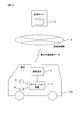
- FIG. 1 is a configuration diagram of a navigation system according to an embodiment of the present invention. It is a block diagram which shows the structure of a navigation apparatus. It is a figure which shows the example of traffic rule difference data. It is a flowchart of the process which updates traffic rule difference data. It is a flowchart of the process during vehicle travel.
- FIG. 1 shows the configuration of a navigation system according to an embodiment of the present invention.
- This system includes a navigation device 1 and a communication terminal 2 mounted on a vehicle 100, a communication network 3, and a distribution server 4.
- the navigation device 1 and the communication terminal 2 are connected by wired or wireless connection.
- Navigation device 1 detects the current position of vehicle 100, displays a map, and shows the detected current position of vehicle 100 on the map.
- the destination of the vehicle 100 is set for the user who is the driver of the vehicle 100
- the recommended route to the destination is searched, and the vehicle 100 is guided to the destination according to the searched recommended route.
- the navigation device 1 stores map data used for executing such processing.
- the navigation device 1 guides the vehicle 100 in consideration of the difference in traffic rules between that country and the user's country of residence.
- Data for performing vehicle guidance in consideration of the difference in traffic rules for each country is called traffic rule difference data. The details of the traffic rule difference data will be described later in detail.
- the traffic rule difference data can be distributed from the distribution server 4 to the navigation device 1 via the communication terminal 2 and the communication line network 3 in accordance with a user operation.
- the traffic rule difference data downloaded in advance from the distribution server 4 to the information terminal such as a personal computer may be recorded in the memory card 5 or the USB (Universal Serial ⁇ ⁇ ⁇ Bus) memory 6 and read by the navigation device 1.
- the navigation device 1 can perform vehicle guidance in consideration of the difference in traffic rules for each country, using the traffic rule difference data acquired as described above.
- the traffic rule difference data necessary for the navigation device 1 may be stored in advance without distributing the traffic rule difference data from the distribution server 4 to the navigation device 1.
- the communication terminal 2 performs wireless connection with the communication line network 3 as necessary under the control of the navigation device 1.
- a distribution server 4 is connected to the communication line network 3. That is, the navigation device 1 is connected to the distribution server 4 via the communication terminal 2 and the communication line network 3.
- a radio base station (not shown) included in the communication line network 3 is used.
- the wireless base stations can wirelessly communicate with the communication terminals 2 in a predetermined communication area around the wireless base stations, and are scattered throughout the country.
- the communication terminal 2 is a mobile phone, for example.
- the communication network 3 is constructed by, for example, a mobile phone network or the Internet.
- the distribution server 4 is a device for distributing traffic rule difference data.
- the navigation device 1 When the navigation device 1 is used in a country other than the user's country of residence, the user designates his / her country of residence with respect to the navigation device 1 and performs a predetermined operation, whereby the navigation device 1 performs the distribution server 4. It is possible to request distribution of traffic rule difference data.
- the distribution server 4 prepares traffic rule difference data for the two countries between the target country and the country of residence specified by the user, with the country corresponding to the current position of the navigation device 1 as the target country. As described above, the data is distributed to the navigation device 1 via the communication terminal 2 and the communication line network 3.
- the distribution server 4 prepares traffic rule difference data for the two countries of the destination country designated by the user and the country of residence designated by the user, and makes a distribution request. Delivered to the information terminal.
- the distribution server 4 stores bilateral traffic rule difference data for various combinations of countries.
- the traffic rule difference data corresponding to the combination is extracted in the distribution server 4 and distributed to the request source.
- Traffic rule difference data is created in the distribution server 4 and distributed to the request source.
- the memory card 5 and the USB memory 6 are recording media for recording the traffic rule difference data downloaded in advance from the distribution server 4 as described above.
- the navigation device 1 uses the traffic rule difference data. Can be read.
- other types of recording media for example, various CDs and DVDs capable of writing data may be used. Any recording medium may be used as long as it can write the traffic rule difference data downloaded in an information terminal such as a personal computer and the navigation device 1 can read the traffic rule difference data. .
- FIG. 2 is a block diagram showing the configuration of the navigation device 1.
- the navigation device 1 includes a control unit 10, a vibration gyro 11, a vehicle speed sensor 12, a hard disk drive (HDD) 13, a memory card reader 14, a USB interface 15, a GPS (Global Positioning System) receiving unit 16, A display monitor 17, a speaker 18, and an input device 19 are provided.
- a control unit 10 a vibration gyro 11, a vehicle speed sensor 12, a hard disk drive (HDD) 13, a memory card reader 14, a USB interface 15, a GPS (Global Positioning System) receiving unit 16,
- a display monitor 17, a speaker 18, and an input device 19 are provided.
- the control unit 10 includes a microprocessor, various peripheral circuits, a RAM, a ROM, and the like, and executes various processes based on a control program and map data recorded in the HDD 13.
- Various processes for guiding the host vehicle that is, the vehicle 100 to the destination are executed by the control unit 10. For example, a destination search process when setting the destination, a recommended route search process to the set destination, a current position detection process of the vehicle 100, various image display processes, a voice output process, and the like are executed.
- the communication terminal 2 is connected to the control unit 10, and the control unit 10 controls the communication terminal 2 so that the navigation device 1 sends a distribution request for traffic rule difference data to the distribution server 4 in FIG. 1. It can also be done.
- the traffic rule difference data distributed from the distribution server 4 in response to the distribution request is output to the control unit 10 via the communication terminal 2.
- the vibration gyro 11 is a sensor for detecting the angular velocity of the vehicle 100.
- the vehicle speed sensor 12 is a sensor for detecting the vehicle speed of the vehicle 100. Based on the detection results of these sensors, the control unit 10 calculates the movement state of the vehicle 100 at predetermined time intervals, thereby obtaining the amount of movement of the vehicle 100, thereby detecting the current position of the vehicle 100.
- the HDD 13 is a non-volatile recording medium that can rewrite recorded information.
- information such as a control program for executing the processing as described above in the control unit 10, map data, and the traffic rule difference data described above is recorded.
- map data recorded in the HDD 13 the map is represented by being divided into a plurality of sections in a predetermined distance unit. Each of these compartments is called a mesh. That is, in the navigation device 1, map data is managed in units of meshes.
- each road is divided into predetermined road sections. Each of these road sections is called a link. That is, in the map data, each road is composed of a plurality of links. Each of the links is set with a value called a link cost related to the time required for the vehicle to pass. The point connecting the links is called a node. Each of the nodes has position information expressed using map coordinates. Based on the position information of this node, the position and shape of each road represented on the map are determined.
- the map data is recorded on the HDD 13 in the navigation device 1.
- the map data may be recorded on something other than the HDD.
- a flash memory or the like may be used instead of the HDD.
- the memory card reader 14 is a part for reading the traffic rule difference data recorded on the memory card 5.
- the traffic card difference data recorded in the memory card 5 is read out by the memory card reader 14 under the control of the control unit 10.
- the data is output to the HDD 13.
- the traffic rule difference data is read from the memory card 5 in the navigation device 1 and recorded in the HDD 13.
- the USB interface 15 has a slot portion for loading the USB memory 6.
- the traffic rule difference data recorded in the USB memory 6 is read out by the USB interface 15 under the control of the control part 10 and a predetermined interface process is performed. Are output to the HDD 13.
- the traffic rule difference data is read from the USB memory 6 in the navigation device 1 and recorded in the HDD 13.
- the GPS receiver 16 receives a GPS signal transmitted from a GPS satellite and outputs it to the controller 10.
- the GPS signal includes information on the position and transmission time of the GPS satellite that transmitted the GPS signal as information for obtaining the position of the vehicle 100 and the current time. Therefore, by receiving GPS signals from a predetermined number or more of GPS satellites, the current position and current time of the vehicle 100 can be calculated based on these pieces of information. Based on the current position of the vehicle 100 calculated based on the GPS signal received by the GPS receiver 16 and the current position of the vehicle 100 calculated based on the detection results of the vibration gyro 11 and the vehicle speed sensor 12 described above. Thus, the final current position of the vehicle 100 is obtained.
- the display monitor 17 is a device for displaying various screens in the navigation device 1 and is configured using a liquid crystal display or the like.
- the display monitor 17 displays a map screen.
- the contents of the screen displayed on the display monitor 17 are determined by screen display control performed by the control unit 10.
- the display monitor 17 is installed at a position where the user can easily see, for example, on the dashboard of the vehicle 100 or in the instrument panel.
- the speaker 18 outputs various audio information related to the traveling of the vehicle under the control of the control unit 10. For example, route guidance voice for guiding the vehicle to the destination according to the recommended route, various warning sounds, and the like are output.
- the input device 19 is a device for a user to perform various input operations for operating the navigation device 1, and has various input switches.
- the user operates the input device 19 to input, for example, the name of a facility or point desired to be set as a destination, select a destination from registered locations registered in advance, or display a map in an arbitrary direction. Or scroll.
- the input device 19 can be realized by an operation panel, a remote controller, or the like. Alternatively, the input device 19 may be realized by a touch panel integrated with the display monitor 17.
- the navigation device 1 searches for a route to the destination where the total of the link costs is minimum, for example, based on the link cost set in the map data.
- the route is set as a recommended route.
- the recommended route set in this way is displayed on the map in a display form distinguishable from other roads. Thereafter, the navigation device 1 displays a map around the current location, and guides the vehicle 100 to the destination according to the set recommended route.
- the navigation device 1 can perform vehicle guidance considering the difference in traffic rules for each country. That is, when the vehicle 100 is traveling in a country different from the country of residence of the user, the user is informed of the difference between the traffic rules in the country of residence of the user and the traffic rules in the country of travel of the vehicle 100 as necessary. To alert the user. This avoids inconveniences such as unintentionally committing a traffic violation and allows the user to drive the vehicle 100 with peace of mind even in a country different from his / her country of residence.
- FIG. 3 is a diagram showing an example of traffic rule difference data used in the navigation device 1.
- the traffic rule difference data is composed of, for example, a difference table shown in FIG. 3A, guidance voice data shown in FIG. 3B, and image data shown in FIG.
- the difference table in FIG. 3A classifies whether or not there is a difference between the traffic rules in the home country, that is, the user's country of residence, and the traffic rules in the country corresponding to the travel destination, that is, the current position of the vehicle 100, for each item. It is the data expressed.
- signs 21, 22, and 23 indicate whether or not there is a difference in traffic rules between the home country and the destination country for each item of a right turn at an intersection without a signal, a right turn at an intersection with a signal, and a level crossing.
- Each column is shown in the difference table.
- the column 21 indicates “ ⁇ ” meaning a blank. This means that there is no difference in traffic rules between the two countries for a right turn at an intersection where there is no signal, and there is no corresponding guidance voice data and image data.
- the column 22 indicates “guidance voice data 1” and “image data 1”. This indicates that there is a difference in traffic rules between the two countries for a right turn at an intersection where a signal is present, and a reference destination of guidance voice data and image data for guiding the difference to the user.
- “guidance voice data 2” is shown. This indicates that there is a difference in traffic rules between the two countries regarding the passage of a railroad crossing, and the reference destination of the guidance voice data for guiding the difference to the user.
- the guidance voice data in FIG. 3 (b) is vehicle guidance data representing voice to be output from the speaker 18 when there is a difference in traffic rules between the home country and the destination country, and the difference in FIG. 3 (a). It is classified for each corresponding item in the table. For example, “guidance voice data 1” indicated by reference numeral 31 corresponds to the difference in the traffic rules for the right turn at the intersection 22 where the signal is present in the difference table of FIG. “Guidance voice data 2” indicated by reference numeral 32 corresponds to the difference in the traffic rule for the passage 23 in the difference table of FIG.
- the image data in FIG. 3C is vehicle guidance data representing an image to be displayed on the display monitor 17 when there is a difference in traffic rules between the home country and the destination country, and the guidance in FIG. Similar to the audio data, the items are classified for each corresponding item in the difference table of FIG. For example, “image data 1” indicated by reference numeral 33 corresponds to the difference in traffic rules for a right turn at an intersection with a signal in the column 22 in the difference table of FIG.
- the navigation device 1 When the vehicle 100 is traveling in a country different from the user's country of residence, the navigation device 1 performs vehicle guidance considering the difference in traffic rules for each country based on the traffic rule difference data as described above. . Specifically, based on the difference table illustrated in FIG. 3A, the difference between the traffic rules in the home country, that is, the user's country of residence, and the traffic rules in the country corresponding to the destination, that is, the current position of the vehicle 100. Is determined for each item of the difference table. Then, for the item determined to have a difference, the guidance voice data and / or image data corresponding to the item is specified from the guidance voice data of FIG. 3B and / or the image data of FIG. To do. Vehicle guidance is performed by outputting sound based on the guidance voice data thus identified from the speaker 18 or displaying an image based on the image data on the display monitor 17.
- the navigation device 1 faces the vehicle 100 at the intersection in front of the vehicle 100 based on “guidance voice data 1” of reference numeral 31 and “image data 1” of reference numeral 33, for example.
- the user can be notified that a right turn is possible when the direction signal indicates a stop.
- the user can be notified that there is no need to pause before the crossing when the vehicle 100 passes the crossing.
- the traffic rule difference data shown in FIG. 3 is merely an example, and the content of the traffic rule difference data is not limited to this.
- the difference table may indicate whether or not there is a difference in traffic rules between the user's country of residence and the country corresponding to the current position of the vehicle 100. it can.
- various information such as an address number indicating the data storage destination can be used as information for referring to the corresponding guidance voice data and image data from the difference table.
- data in a format other than the guidance voice data and image data for example, program data for causing the navigation device 1 to execute a specific operation is included in the traffic rule difference data, and guidance is performed using this data. Also good.
- the traffic rule difference data having various contents can be used in the navigation device 1.
- FIG. 4 shows a flowchart of processing for updating the traffic rule difference data recorded in the HDD 13 in the navigation device 1.
- the processing of this flowchart is performed when the traffic rule difference data is downloaded from the distribution server 4 according to the user's operation, or when the previously downloaded traffic rule difference data is read from the memory card 5 or the USB memory 6. 10 is executed.
- step S10 the control unit 10 acquires residence country data indicating the residence country designated by the user and traffic rule difference data.
- the traffic rule difference data is transmitted from the distribution server 4 to the communication terminal 2 via the communication network 3 in response to the traffic rule difference data distribution request as described above. Is sent.
- the country of residence data corresponding to the country of residence designated by the user is also transmitted.
- the communication terminal 2 receives the residence country data and the traffic rule difference data.
- the navigation device 1 obtains the residence country data and the traffic rule difference data. Is done.
- step S20 the control unit 10 determines whether or not the residence country data and the traffic rule difference data acquired in step S10 have been stored in the HDD 13. If the data has already been recorded in the HDD 13, the control unit 10 determines that the data has been saved, and ends the processing shown in the flowchart of FIG. In this case, the traffic rule difference data is not updated. On the other hand, if the data is not recorded in the HDD 13, the control unit 10 determines that the data has not been saved and proceeds to step S30.
- step S30 the control unit 10 records the residence country data and the traffic rule difference data acquired in step S10 in the HDD 13, and stores these data. At this time, if other traffic rule difference data has already been recorded, the traffic rule difference data obtained by deleting it may be overwritten and saved, or the traffic rule difference data obtained without leaving it may be stored. It may be newly saved.
- step S30 the control part 10 will complete
- the traffic rule difference data recorded in the HDD 13 is updated, and the acquired residence country data and traffic rule difference data are newly stored in the navigation device 1.
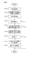
- FIG. 5 shows a flowchart of processing executed in the navigation device 1 when the vehicle 100 is traveling. The process of this flowchart is executed by the control unit 10 every predetermined processing cycle whenever the navigation device 1 is operating.
- step S100 the control unit 10 updates the own vehicle position, that is, the position of the vehicle 100, based on the current position of the vehicle 100 obtained as described above.
- the process for detecting the current position of the vehicle 100 is executed in parallel with the process of FIG. By updating the vehicle position based on the latest current position obtained by this process, the process of step S100 is executed.
- step S110 the control unit 10 acquires map data within a predetermined range from the vehicle position updated in step S100 from the HDD 13.
- map data included in a predetermined range centered on the vehicle position for example, a range within 10 km from the vehicle position
- the road on which the vehicle 100 is traveling may be specified, and map data within a predetermined range may be acquired along the road.
- the recommended route from the departure point to the destination is searched and the vehicle 100 is guided to the destination according to the recommended route, the recommended route is within a predetermined range along the recommended route ahead of the vehicle position. You may make it acquire map data.
- an arbitrary range determined based on the vehicle position can be set as a map data acquisition target range.
- step S120 the control unit 10 specifies a guidance target to be a target of vehicle guidance based on the map data acquired in step S110.
- various road elements designated in advance as candidates for guidance include roads that have traffic restrictions such as intersections, railroad crossings, junctions, junctions, interchanges, one-way traffic, and lanes on which only specific vehicles can travel
- An object to be guided is specified by selecting the map data that is closest to the vehicle position from among roads and the like. At this time, a plurality of road elements may be targeted for guidance.
- the selection range of the road element is determined as the guidance target in consideration of the recommended route and the traveling direction of the vehicle 100. Further, when the recommended route is not set, a future route is estimated from the road on which the vehicle 100 is currently traveling and the traveling direction of the vehicle 100, and the estimation result is reflected to determine the road element as the guidance target.
- the selection range may be determined.
- step S130 the control unit 10 determines whether or not the guidance target is specified in step S120. If the guidance target is specified by selecting at least one road element satisfying the above conditions from among the road elements included in the map data acquired in step S110, the process proceeds to step S140. On the other hand, if there is no road element that satisfies the above conditions in the map data acquired in step S110, and the guidance target is not specified for that purpose, the control unit 10 ends the process shown in the flowchart of FIG. To do. In this case, the vehicle guidance considering the difference in traffic rules between the country corresponding to the vehicle position and the user's country of residence is not performed.
- step S140 the control unit 10 determines whether the country corresponding to the vehicle position updated in step S100 matches the country of residence of the user who is the driver. This determination is made based on the country of residence data recorded in the HDD 13 in step S30 of FIG. That is, it is determined which country the vehicle position corresponds to based on the map data, and it is determined whether or not the country and the user's country of residence represented by the country of residence data match. As a result, if the country corresponding to the vehicle position is different from the country where the user resides, the control unit 10 determines that the vehicle guidance should be performed in consideration of the difference in traffic rules in these countries, and the process proceeds to step S150. On the other hand, when the country corresponding to the vehicle position matches the country where the user resides, the control unit 10 determines that the vehicle guidance is unnecessary, and ends the process illustrated in the flowchart of FIG.
- step S150 the control unit 10 searches the difference table included in the traffic rule difference data recorded in the HDD 13 in step S30 of FIG. 4 for an item corresponding to the guidance target specified in step S120.
- step S160 the control unit 10 determines whether there is a difference in the traffic rules regarding the guidance target between the country corresponding to the vehicle position and the country of residence of the user, based on the difference table search result in step S150. Determine. For example, as shown in columns 22 and 23 in FIG. 3A, the reference field of the guidance voice data and image data is shown in the item column of the difference table corresponding to the guidance target, and there is a difference in the traffic rules. , The control unit 10 determines that there is a difference and proceeds to step S160.
- step S170 based on the difference table search result in step S150, the control unit 10 acquires guidance voice data and / or image data corresponding to the difference in traffic rules for the guidance target.
- the guidance voice data and the image data included in the traffic rule difference data recorded in the HDD 13 in step S30 of FIG. 4 the guidance voice data and the image referred to by the item column of the difference table corresponding to the guidance target. Get the data.
- “guidance voice data 1” indicated by reference numeral 31 in FIG.” “Image data 1” indicated by reference numeral 33 in (c) is acquired.
- “guidance voice data 2” indicated by reference numeral 32 in FIG. 3B is acquired by referring to the column 23 in FIG.
- step S180 the control unit 10 performs voice output and / or image display based on the guidance voice data and / or image data acquired in step S170. That is, when the guidance voice data is acquired in step S170, the voice based on the guidance voice data is output from the speaker 18. When image data is acquired in step S170, an image based on the image data is displayed on the display monitor 17. By performing voice output and image display in this way, vehicle guidance that takes into account the difference in traffic rules between the country corresponding to the vehicle position and the country of residence of the user is performed for the guidance target.
- the vehicle guidance according to the present invention by voice output and image display as described above has a distance from the vehicle 100 to the guidance object, for example, as in the conventional vehicle guidance performed for guiding the vehicle 100 to the destination. This can be done when the value falls within a predetermined value.
- the tone of the voice output at this time is preferably different from the tone of the conventional vehicle guidance voice.
- a map is displayed on the display monitor 17, and a part or all of the recommended route is shown on the map and the position of the guidance target is indicated.
- the vehicle guidance of the present invention may be performed.
- the position of the guidance target and the contents of the difference in traffic rules for the guidance target are displayed on the map in an easy-to-understand manner using icons or the like.
- the difference in traffic rules between the country corresponding to the vehicle position and the user's country of residence for the guidance target is explained in an easy-to-understand manner using video or voice. Also good.
- step S180 the control part 10 will complete
- road elements to be guided are sequentially identified according to the vehicle position.
- vehicle guidance is performed as necessary according to the difference in traffic rules between the country corresponding to the vehicle position and the user's country of residence for the guidance target.
- the navigation device 1 detects the current position of the vehicle 100 based on the GPS signal received by the GPS receiver 16 and the detection results of the vibration gyro 11 and the vehicle speed sensor 12 by the processing of the controller 10.
- the own vehicle position is updated (step S100). Based on the current location, it is determined whether or not to perform vehicle guidance according to the difference between the traffic rules in the user's country of residence and the traffic rules in the country corresponding to the current location (step S140), and performs vehicle guidance. If it is determined that it should be, vehicle guidance is performed (step S180). Since it did in this way, the appropriate vehicle guidance which considered the difference of the traffic rule for every country with respect to the user who is the driver
- the navigation device 1 stores in the HDD 13 traffic rule difference data relating to the difference between the traffic rule in the country of residence of the user and the traffic rule in the country corresponding to the current position, and the vehicle is based on the traffic rule difference data. Guided. Thereby, suitable vehicle guidance can be performed according to the difference of the traffic rule between a user's residence country and the country corresponding to the present position.
- the navigation device 1 specifies a guidance target to be a target of vehicle guidance by the processing of the control unit 10 (step S120). Further, there are a difference table for each item indicating whether or not there is a difference between the traffic rule in the user's country of residence and the traffic rule in the country corresponding to the current position, and data for vehicle guidance according to the difference for each item.
- the traffic rule difference data including the guidance voice data and the image data is stored in the HDD 13. Then, by the processing of the control unit 10, for the item corresponding to the guidance target specified in step S 120, the HDD 13 determines whether there is a difference between the traffic rule in the country where the user resides and the traffic rule in the country corresponding to the current position.
- step S160 Is determined from the difference table included in the traffic rule difference data stored in (step S160), and based on the determination result and the guidance voice data and / or image data included in the traffic rule difference data stored in the HDD 13
- step S180 vehicle guidance is performed.
- the vehicle guidance which considered the difference of the traffic rule for every country about the guidance object which should be made into the object of vehicle guidance can be performed exactly.
- step S180 If the control unit 10 determines that there is a difference in the item corresponding to the guidance target according to the determination result in step S160, the control unit 10 performs vehicle guidance in step S180, but determines that there is no difference.
- the vehicle guidance is not performed without executing step S180. Thereby, it is possible to prevent the unnecessary vehicle guidance from being performed by performing the vehicle guidance considering the difference in the traffic rules for each country only when necessary for the guidance target.
- the navigation device 1 reads the traffic rule difference data from the memory card 5 or the USB memory 6 in which the traffic rule difference data is recorded by using the memory card reader 14 or the USB interface 15 by the process of the control unit 10.
- traffic rule difference data is acquired (step S10).
- the traffic rule difference data is acquired by receiving the traffic rule difference data using the communication terminal 2 from the distribution server 4 in which the traffic rule difference data is recorded (step S10).
- the traffic rule difference data thus obtained is stored in the HDD 13 (step S30), so that the traffic rule difference data is stored in the HDD 13.
- the optimal traffic rule difference data can be easily and surely acquired according to the traffic rule difference between the user's country of residence and the country corresponding to the current position, and can be stored in the HDD 13.
- step S140 the control unit 10 determines whether or not the country corresponding to the current position matches the user's country of residence specified in advance, thereby determining the traffic rules and the current position in the user's country of residence. Judgment is made as to whether or not to perform vehicle guidance according to the difference with the traffic rules in the corresponding country. Thereby, it can be reliably determined whether or not to perform vehicle guidance.
- the navigation device 1 can search for a recommended route from the departure point to the destination by the processing of the control unit 10.
- step S180 a map for showing the recommended route is displayed on the display monitor 17, and the position of the guidance target specified on the recommended route by the process of step S120 is shown on the map for vehicle guidance. In this way, it is possible to provide easy-to-understand vehicle guidance for various guidance targets on the recommended route before the vehicle 100 approaches the guidance target.
- the example in which vehicle guidance is performed in consideration of the difference in traffic rules for each country regarding the right turn or crossing at a crossing where a signal is present has been described.
- the vehicle guidance by can be performed.
- a country such as Japan where the vehicle passes on the left side of the road
- the vehicle guidance is provided for a left turn at an intersection with a signal. It is preferable to carry out.
- a traveling method of a roundabout such as a roundabout that is not so common in Japan may be described.
- vehicle guidance may be performed to notify the user of that.
- the navigation apparatus 1 can provide vehicle guidance for notifying the user of various things in consideration of differences in traffic rules between countries.
- the traffic rule difference data acquired in step S10 of FIG. 4 includes a difference table that indicates whether or not there is a difference in traffic rules between the user's residential area and the area corresponding to the current position of the vehicle 100. . By searching this difference table in step S150 of FIG.
- step S180 it is determined whether or not there is a difference in the traffic rules for the guidance target between the area corresponding to the vehicle position and the user's residence area. If there is, the vehicle guidance according to the difference is performed in step S180. If it does in this way, suitable vehicle guidance which considered the difference in the traffic rule for every area can be performed to the user who is the driver of vehicles 100.
- the navigation apparatus 1 mounted on the vehicle 100 has been described as an example, but the present invention is not limited to this.
- the present invention can be applied to a portable navigation device that can be carried by a user.
- the navigation application provided as an application that can be executed in an information terminal such as a personal computer, a mobile phone, and a smartphone, and an information terminal that functions as a navigation device by executing the application are also within the scope of the present invention. is there.
- various types of navigation devices can be included in the scope of the present invention.
Landscapes
- Engineering & Computer Science (AREA)
- Radar, Positioning & Navigation (AREA)
- Remote Sensing (AREA)
- Automation & Control Theory (AREA)
- Physics & Mathematics (AREA)
- General Physics & Mathematics (AREA)
- Navigation (AREA)
Abstract
L'invention concerne un appareil de navigation qui comprend : une unité de détection de position actuelle qui détecte une position actuelle ; une unité de détermination qui détermine, sur la base de la position actuelle détectée par l'unité de détection de position actuelle, si l'orientation basée sur la différence entre les règles de circulation pour la zone de résidence d'un utilisateur et les règles de circulation pour une zone correspondant à la position actuelle devrait être émise ; et une unité d'orientation qui émet l'orientation lorsque l'unité de détermination détermine que l'orientation devrait être émise.
Priority Applications (1)
| Application Number | Priority Date | Filing Date | Title |
|---|---|---|---|
| PCT/JP2011/063841 WO2012172675A1 (fr) | 2011-06-16 | 2011-06-16 | Appareil de navigation et procédé de navigation |
Applications Claiming Priority (1)
| Application Number | Priority Date | Filing Date | Title |
|---|---|---|---|
| PCT/JP2011/063841 WO2012172675A1 (fr) | 2011-06-16 | 2011-06-16 | Appareil de navigation et procédé de navigation |
Publications (1)
| Publication Number | Publication Date |
|---|---|
| WO2012172675A1 true WO2012172675A1 (fr) | 2012-12-20 |
Family
ID=47356701
Family Applications (1)
| Application Number | Title | Priority Date | Filing Date |
|---|---|---|---|
| PCT/JP2011/063841 WO2012172675A1 (fr) | 2011-06-16 | 2011-06-16 | Appareil de navigation et procédé de navigation |
Country Status (1)
| Country | Link |
|---|---|
| WO (1) | WO2012172675A1 (fr) |
Cited By (3)
| Publication number | Priority date | Publication date | Assignee | Title |
|---|---|---|---|---|
| JP2017157131A (ja) * | 2016-03-04 | 2017-09-07 | 株式会社デンソー | 推定装置 |
| CN110530380A (zh) * | 2018-05-23 | 2019-12-03 | 上海擎感智能科技有限公司 | 一种基于车载终端的城际驾驶交规差别的提醒方法、系统及车载终端 |
| CN111221448A (zh) * | 2018-11-16 | 2020-06-02 | 本田技研工业株式会社 | 信息提供方法、存储介质及信息提供系统 |
Citations (3)
| Publication number | Priority date | Publication date | Assignee | Title |
|---|---|---|---|---|
| JP2005241267A (ja) * | 2004-02-24 | 2005-09-08 | Victor Co Of Japan Ltd | 車載用経路案内誘導装置 |
| WO2006077967A1 (fr) * | 2005-01-20 | 2006-07-27 | Pioneer Corporation | Peripherique de navigation, procede et programme associes |
| JP2008122281A (ja) * | 2006-11-14 | 2008-05-29 | Denso Corp | カーナビゲーション装置 |
-
2011
- 2011-06-16 WO PCT/JP2011/063841 patent/WO2012172675A1/fr active Application Filing
Patent Citations (3)
| Publication number | Priority date | Publication date | Assignee | Title |
|---|---|---|---|---|
| JP2005241267A (ja) * | 2004-02-24 | 2005-09-08 | Victor Co Of Japan Ltd | 車載用経路案内誘導装置 |
| WO2006077967A1 (fr) * | 2005-01-20 | 2006-07-27 | Pioneer Corporation | Peripherique de navigation, procede et programme associes |
| JP2008122281A (ja) * | 2006-11-14 | 2008-05-29 | Denso Corp | カーナビゲーション装置 |
Cited By (3)
| Publication number | Priority date | Publication date | Assignee | Title |
|---|---|---|---|---|
| JP2017157131A (ja) * | 2016-03-04 | 2017-09-07 | 株式会社デンソー | 推定装置 |
| CN110530380A (zh) * | 2018-05-23 | 2019-12-03 | 上海擎感智能科技有限公司 | 一种基于车载终端的城际驾驶交规差别的提醒方法、系统及车载终端 |
| CN111221448A (zh) * | 2018-11-16 | 2020-06-02 | 本田技研工业株式会社 | 信息提供方法、存储介质及信息提供系统 |
Similar Documents
| Publication | Publication Date | Title |
|---|---|---|
| JP3842799B2 (ja) | 地図データ提供装置 | |
| JP3942987B2 (ja) | ナビゲーションシステム、地図差分データの配信装置、及び車載用ナビゲーション装置 | |
| CN108225347B (zh) | 通信终端、移动引导系统以及移动引导方法 | |
| JP2015017944A (ja) | 自動運転支援装置 | |
| JP2006071753A (ja) | 地図表示装置 | |
| JPWO2008075492A1 (ja) | 地図表示装置 | |
| JP7013512B2 (ja) | 情報処理装置、経路案内装置、プログラム、及び、情報処理方法 | |
| JP5901319B2 (ja) | ナビゲーション装置 | |
| JP2011163951A (ja) | ナビゲーション装置、ナビゲーションシステム | |
| JP2007010598A (ja) | 地図情報更新方法及びナビゲーション装置 | |
| WO2012172675A1 (fr) | Appareil de navigation et procédé de navigation | |
| JP2005069967A (ja) | 車載用ナビゲーション装置 | |
| JP4931686B2 (ja) | ナビゲーション装置 | |
| JP5126272B2 (ja) | ナビゲーションシステム | |
| JP2009092559A (ja) | ナビゲーション装置 | |
| JP2012149957A (ja) | 車載地図表示装置 | |
| JP6598858B2 (ja) | 経路案内装置 | |
| JP5416916B2 (ja) | ナビゲーション装置 | |
| JP2007093291A (ja) | ナビゲーション装置、方法及びプログラム | |
| JP5255893B2 (ja) | ナビゲーション装置 | |
| JP2009092502A (ja) | ナビゲーション装置、配信装置 | |
| JP6161446B2 (ja) | 車載装置 | |
| JP6398646B2 (ja) | 案内システム、案内方法、及び案内プログラム | |
| JP5145107B2 (ja) | ナビゲーション装置、地図配信システム | |
| JP4903592B2 (ja) | ナビゲーション装置 |
Legal Events
| Date | Code | Title | Description |
|---|---|---|---|
| 121 | Ep: the epo has been informed by wipo that ep was designated in this application |
Ref document number: 11867585 Country of ref document: EP Kind code of ref document: A1 |
|
| NENP | Non-entry into the national phase |
Ref country code: DE |
|
| 122 | Ep: pct application non-entry in european phase |
Ref document number: 11867585 Country of ref document: EP Kind code of ref document: A1 |
|
| NENP | Non-entry into the national phase |
Ref country code: JP |