EP2335085B1 - Traitement de signaux de radionavigation utilisant une combinaison widelane - Google Patents
Traitement de signaux de radionavigation utilisant une combinaison widelane Download PDFInfo
- Publication number
- EP2335085B1 EP2335085B1 EP09815671A EP09815671A EP2335085B1 EP 2335085 B1 EP2335085 B1 EP 2335085B1 EP 09815671 A EP09815671 A EP 09815671A EP 09815671 A EP09815671 A EP 09815671A EP 2335085 B1 EP2335085 B1 EP 2335085B1
- Authority
- EP
- European Patent Office
- Prior art keywords
- widelane
- satellites
- group
- phase
- measurements
- Prior art date
- Legal status (The legal status is an assumption and is not a legal conclusion. Google has not performed a legal analysis and makes no representation as to the accuracy of the status listed.)
- Active
Links
- 238000012545 processing Methods 0.000 title description 4
- 238000005259 measurement Methods 0.000 claims description 72
- 238000000034 method Methods 0.000 claims description 36
- 230000001427 coherent effect Effects 0.000 claims description 15
- 238000012937 correction Methods 0.000 claims description 9
- 230000009471 action Effects 0.000 claims description 6
- 230000000694 effects Effects 0.000 description 6
- 230000008901 benefit Effects 0.000 description 3
- 230000004069 differentiation Effects 0.000 description 3
- 230000006870 function Effects 0.000 description 3
- 230000008569 process Effects 0.000 description 3
- 241000607056 Stenodus leucichthys Species 0.000 description 2
- 230000000903 blocking effect Effects 0.000 description 2
- 239000000969 carrier Substances 0.000 description 2
- 230000008859 change Effects 0.000 description 2
- 230000001934 delay Effects 0.000 description 2
- 230000001419 dependent effect Effects 0.000 description 2
- 235000008694 Humulus lupulus Nutrition 0.000 description 1
- 241000897276 Termes Species 0.000 description 1
- 230000006399 behavior Effects 0.000 description 1
- 230000005540 biological transmission Effects 0.000 description 1
- 238000004891 communication Methods 0.000 description 1
- 238000010276 construction Methods 0.000 description 1
- 230000009977 dual effect Effects 0.000 description 1
- 238000009472 formulation Methods 0.000 description 1
- 150000003278 haem Chemical class 0.000 description 1
- 239000011159 matrix material Substances 0.000 description 1
- 239000000203 mixture Substances 0.000 description 1
- 238000011084 recovery Methods 0.000 description 1
- 230000009467 reduction Effects 0.000 description 1
- 230000000717 retained effect Effects 0.000 description 1
- 238000001228 spectrum Methods 0.000 description 1
- 230000009466 transformation Effects 0.000 description 1
Images
Classifications
-
- G—PHYSICS
- G01—MEASURING; TESTING
- G01S—RADIO DIRECTION-FINDING; RADIO NAVIGATION; DETERMINING DISTANCE OR VELOCITY BY USE OF RADIO WAVES; LOCATING OR PRESENCE-DETECTING BY USE OF THE REFLECTION OR RERADIATION OF RADIO WAVES; ANALOGOUS ARRANGEMENTS USING OTHER WAVES
- G01S19/00—Satellite radio beacon positioning systems; Determining position, velocity or attitude using signals transmitted by such systems
- G01S19/38—Determining a navigation solution using signals transmitted by a satellite radio beacon positioning system
- G01S19/39—Determining a navigation solution using signals transmitted by a satellite radio beacon positioning system the satellite radio beacon positioning system transmitting time-stamped messages, e.g. GPS [Global Positioning System], GLONASS [Global Orbiting Navigation Satellite System] or GALILEO
- G01S19/42—Determining position
- G01S19/43—Determining position using carrier phase measurements, e.g. kinematic positioning; using long or short baseline interferometry
- G01S19/44—Carrier phase ambiguity resolution; Floating ambiguity; LAMBDA [Least-squares AMBiguity Decorrelation Adjustment] method
-
- G—PHYSICS
- G01—MEASURING; TESTING
- G01S—RADIO DIRECTION-FINDING; RADIO NAVIGATION; DETERMINING DISTANCE OR VELOCITY BY USE OF RADIO WAVES; LOCATING OR PRESENCE-DETECTING BY USE OF THE REFLECTION OR RERADIATION OF RADIO WAVES; ANALOGOUS ARRANGEMENTS USING OTHER WAVES
- G01S19/00—Satellite radio beacon positioning systems; Determining position, velocity or attitude using signals transmitted by such systems
- G01S19/01—Satellite radio beacon positioning systems transmitting time-stamped messages, e.g. GPS [Global Positioning System], GLONASS [Global Orbiting Navigation Satellite System] or GALILEO
- G01S19/03—Cooperating elements; Interaction or communication between different cooperating elements or between cooperating elements and receivers
- G01S19/07—Cooperating elements; Interaction or communication between different cooperating elements or between cooperating elements and receivers providing data for correcting measured positioning data, e.g. DGPS [differential GPS] or ionosphere corrections
- G01S19/072—Ionosphere corrections
-
- G—PHYSICS
- G01—MEASURING; TESTING
- G01S—RADIO DIRECTION-FINDING; RADIO NAVIGATION; DETERMINING DISTANCE OR VELOCITY BY USE OF RADIO WAVES; LOCATING OR PRESENCE-DETECTING BY USE OF THE REFLECTION OR RERADIATION OF RADIO WAVES; ANALOGOUS ARRANGEMENTS USING OTHER WAVES
- G01S19/00—Satellite radio beacon positioning systems; Determining position, velocity or attitude using signals transmitted by such systems
- G01S19/01—Satellite radio beacon positioning systems transmitting time-stamped messages, e.g. GPS [Global Positioning System], GLONASS [Global Orbiting Navigation Satellite System] or GALILEO
- G01S19/13—Receivers
- G01S19/24—Acquisition or tracking or demodulation of signals transmitted by the system
- G01S19/25—Acquisition or tracking or demodulation of signals transmitted by the system involving aiding data received from a cooperating element, e.g. assisted GPS
Definitions
- the present invention relates to the field of radionavigation or satellite positioning systems, in particular a method for processing the radionavigation signals emitted by satellites of such a system.
- Satellite positioning systems such as Global Positioning System (GPS), Galileo, GLONASS, QZSS, Compass, IRNSS and others use modulated radionavigation signals called "spread spectrum". These signals essentially convey pseudorandom codes formed of periodically repeating digital sequences, the main function of which is to allow a code division multiple access (CDMA) and the provision of a measurement of the propagation time of the signal transmitted by the satellite.
- CDMA code division multiple access
- the radionavigation signals may also carry a payload.
- the radionavigation signals are formed by modulation of the central frequencies (carriers).
- the radionavigation signals are transmitted in the L1 frequency bands, centered on 1575.42 MHz and L2, centered on 1227.6 MHz.
- the L5 band centered on 1176.45 MHz will be added.
- the satellites of the Galileo constellation will transmit in the bands E2-L1-E1 (the median band portion L1 being the same as that of the GPS), E5a (which, according to the Galileo nomenclature, represents the L5 band provided for the GPS), E5b (centered on 1207.14 MHz) and E6 (centered on 1278.75 MHz).
- Basic measurements that a receiver can perform include code measurements and carrier phase measurements. These elementary measures can obviously be combined with each other.
- the code measurements are typically metric accurate while the phase measurement are accurate to a few mm.
- the phase measurements have the disadvantage that they only deliver the fractional part of the phase difference of the carrier between the transmission by the satellite and the receiver. Phase measurements are therefore ambiguous in the sense that the number of entire cycles between the satellite and the receiver is unknown at the outset. In order to benefit from the accuracy of phase measurements, a receiver must resolve the ambiguities with which they are tainted.
- phase ambiguities are commonly carried out by differentiating phase measurements (single or double differentiation) between satellites and / or between receivers.
- This differentiation technique makes it possible to eliminate the causes of errors (not modeled) that are common to several measurements, and thus makes it possible to display an entire piece of information, the taking into account of which further improves performance.
- this entire information consists of differences of one or more elementary phase ambiguities and generally does not allow to go back to elementary phase ambiguities.
- the object of the present invention is to propose a method for processing radionavigation signals, with the aid of which a GNSS (Global Navigation Satellite System) receiver (abbreviation used here to designate a satellite navigation system providing a global coverage of ) can increase the accuracy of the positioning solution.
- GNSS Global Navigation Satellite System
- a set of satellites is assumed (for example the satellites of a constellation of radionavigation satellites which are "visible" from the geographical location where the receiver is located or a part of them), whose satellites emit each at least two radionavigation signals in separate frequency bands. Each satellite therefore emits at least one first radionavigation signal on a first frequency and a second radionavigation signal on a second frequency distinct from the first.
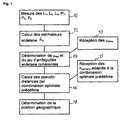
- the receiver which must fix its geographical position receives the first and second signals for each satellite of the set considered and performs, for each satellite of the set, undifferentiated code and phase measurements of these signals.
- the term "undifferentiated measurement” is used in this context to designate an elementary measure, which is not differentiated between satellites or between receivers. It is well known that phase measurements each have an entire ambiguity that is unknown in principle. As a result, for each satellite, the "widelane" combination of the phase measurements of the first and second signals also presents an entire ambiguity that is, a priori, unknown. This ambiguity can be expressed in cycles of the difference frequency of the first and second frequencies and is hereinafter referred to as the first widelane ambiguity (to distinguish it from one or more possible other widelane ambiguities occurring when there are more than two frequency bands in which satellites transmit radionavigation signals). It should also be noted that for each satellite of the set considered there is a first widelane ambiguity associated with this satellite.
- the method for processing the radionavigation signals further comprises the step of determining the first widelane ambiguities in a coherent manner on the set of satellites.
- the receiver having to fix its position uses, in this step, widelane bias, received from a reference system, associated with the satellites of the set of satellites.
- the method also includes the step of subsequently setting the position of the receiver using the received first and second phase code and phase measurements as well as the set of widelane first ambiguities determined in a consistent manner.
- the action of setting the position of the receiver comprises, for each satellite of the set, the determination of a pseudo-distance by means of a combination iono-free, optimized in terms of noise, of measurements of code and the difference of the phase measurements of the first and second signals, compensated for the ambiguity widelane.
- the determination of the pseudo-distance also based on satellite clock values, received from a reference system, associated with the iono-free combination.
- the iono-free combination is predetermined in the sense that the coefficients of the various terms of the combination are known from the reference system side - knowledge at the reference system level of the coefficients being necessary for the reference system to transmit to the receiver the Satellite clock values associated with the optimal combination, at the required rate.
- the coefficients of the optimized combination can be agreed in advance between the receiver and the reference system or fixed once and for all for all satellites.
- the numerical values of these coefficients are preferably chosen according to the noise characteristics of the radionavigation signals.
- the method according to the invention makes it possible to dispense with complex network resolutions to identify a part of the elementary ambiguities.
- the consequence of the knowledge of the whole coherent widelane ambiguity set is that a new unambiguous observable (ie the difference between the phase measurements, compensated for the widelane ambiguity) is available directly at the receiver level.
- two measures of code on each frequency An analysis of the combinations of these three observables shows that it is possible to construct then a combination giving a pseudo-distance corrected ionospheric effects (thus "iono-free") less noisy than the combinations using only the code measurements.
- this combination is less sensitive to multipath because it relies on phase measurements.
- each satellite of the set considered emits a third radionavigation signal on a third frequency distinct from the first and second frequencies.
- the method therefore comprises, at the level of the receiver and for each satellite of the set, receiving the third signal as well as the action of making undifferentiated code and phase measurements of the third received signal.
- the widelane combination of phase measurements of the first and third signals presents a second widelane ambiguity that is unknown at first sight.
- the widelane combination of the phase measurements of the second and third signals also presents a whole widelane ambiguity, which is a priori unknown, but that this case does not require a separate discussion since it suffices to invert the denominations of the first and second signals.
- the receiver determines a set of second consistent widelane ambiguities on the set of satellites so that the action of setting the position of the receiver also relies on the code and phase measurements of the third signals as well as the second determined widelane ambiguities of coherently across the set of satellites.
- the determination of widelane first and / or second ambiguities coherently over the set of satellites includes the reception of widelane bias associated with the satellites from a reference system (eg a network). geographically fixed reference receivers).
- a reference system eg a network. geographically fixed reference receivers.
- the receiver then identifies a set of integer values of the first widelane ambiguities which are in accordance with this modeling for the set of satellites.
- This identification of the integer values can notably be carried out using simple differences between satellites of the modelizations of the first ambiguities widelane or by simultaneous resolution of the integer values and the term ⁇ rec with a law of evolution adapted in the time.
- the possible determination of the second widelane ambiguities in a coherent manner on the set of satellites is carried out in a manner analogous to the determination of the first widelane ambiguities.
- the first, second and, where appropriate: third, frequencies are chosen from among the frequencies L1, L2, L5 and E6.
- At least one has a noise of less than 0.5 m, preferably less than 0.25 m.
- the position is preferably set using at least three frequencies (so as to have at least two observables of phase widelane).
- One aspect of the invention relates to a GNSS receiver comprising means for implementing the method.
- Such means advantageously comprise a program, stored in a permanent or non-permanent memory of the receiver and configured so that it operates the receiver according to the method described when it is executed in a receiver.
- ⁇ 1 vs f 1
- ⁇ 2 vs f 2
- c the speed of light.
- f 0 10.23 MHz.
- the code measurements P 1 , P 2 are expressed in units of length, while the phase measurements L 1 , L 2 are expressed in cycles.
- bias ⁇ 12 , ⁇ 1 , ⁇ 2 may vary with time.
- ⁇ is common to all measurements made at the same date on the different channels of the receiver.
- equation (4) actually represents a system of equations, which can be solved, for example, by the least squares technique. This method of resolution is not detailed here. It is important to note that the solution of the system (4) is not unique, but that there is a family of solutions that are deduced from each other by the entire transformation [ ⁇ rec (t), K k ] ⁇ [ ⁇ rec (t) + n, K k -n], for all n integer.
- the values ⁇ eme deserve an explanation, because without knowledge of these values, the receiver will not be able to access the coherent solution of widelane ambiguities.
- the ⁇ em values are preferably determined level of a network of reference receivers. We use the property that, in practice, the ⁇ eme are slowly changing functions of time.
- the technique for determining ⁇ th at a reference network has been the subject of the patent application registered under the number FR 0754139 . This method also uses the system equations (4).
- the process of determining the ⁇ eme starts with the choice of a first station of the reference network whose ⁇ rec values (noted hereinafter ⁇ rec, ref ) are stable over time.
- the ⁇ eme can be communicated to the receiver to determine its position by any suitable means, for example in the navigation message of the satellite constellation considered, by terrestrial broadcasting or from an SBAS satellite, by Intenet, by mobile radiotelephony, etc. Given the low rate of change of ⁇ th, little bandwidth is needed to get their values to the receiver to fix its position.
- ⁇ h is here the difference between receiver clock and transmitter clock, referenced to the combination of pseudo-distances "iono-free" (without ionospheric contribution) ( ⁇ P 1 -P 2 ) / ( ⁇ -1); ⁇ here corresponds to the 'TGD' between receiver and transmitter, because the equations are referenced to the iono- free combination, unlike equations (1). This does not change the generality, but refers equations (6) to what is usually used in the GPS system.
- the equation of the observable widelane is particular because the set of ambiguities widelane is determined to an integer (denoted n).
- the h opt values are preferably calculated at a reference system and transmitted to the receiver (step 15).
- the determination of the geographical position of the receiver (step 18) is finally done thanks to the set of calculated pseudo-distances.
- the combination that is used in the receiver must be set in advance (for example by convention, or by definition of a protocol) so that the values h opt, eme are consistent with the combination.
- the determination of h opt, eme can be done conventionally at the level of the reference network through the system of equations (6). Note that at the reference network, the positions of the reference receivers (thus also the pseudo-distances) being known, the system (6) is then solved for the unknowns h opt, eme , h opt, rec etc.
- Example 1 GPS case (dual frequency)
- the table below shows the order of magnitude of the optimal noise in the case of GPS in dual-frequency mode (units in meters, frequencies 1 and 2 respectively of 1575.42 MHz and 1227.60 MHz): Noise phase 1, 2 (m) Noise code 1, 2 (m) Resulting noise (m) Inf; Inf 1.0; 1.0 2.97 0.01; 0.01 1.0; 1.0 2.78 0.01; 0.01 1.0; 0.1 0.36 0.01; 0.01 0.1; 1.0 0.45 0.01; 0.01 0.1; 0.1 0.28
- the first line of this table corresponds to the classical case of the iono-free combination of code. Note that the use of the widelane phase combination is only interesting if at least one of the code measurements has a low noise. However, the last three lines of the table are hypothetical cases, because the noise of the GPS signal code measurements is of the order of one meter. We also see that if we assume that the two measures of code have a noise of 10 cm, we arrive at a noise of 30 cm on the iono-free combination of code, which shows that the contribution of the combination of phase widelane is not significant if both code measures are good (last line of the table). As an indication, if we carried out a complete resolution of the ambiguities, the resulting noise would be 3 cm, with the assumptions retained.
- Example 2 GPS case (tri-frequency)
- Example 1 it is the two less noisy combinations that contribute essentially to the performance.
- the first line of the table shows that the addition of the third frequency does not add much to the resulting noise obtained by the iono-free combination of code (which does not diminish the interest of three frequencies, for reasons of robustness, multipath, etc.).
- the use of this capability is based on the availability, at the receiver, of different data, namely the widelane biases of the satellites (the values of the ⁇ eme (t)) as well as the satellite clock data associated with the optimal combination used. at the receiver.
- the widelane ⁇ eme biases are calculated for the widelane combination (s) used and for all satellites of the constellation at a reference system level.
- the reference system determines the clocks h opt, eme for the optimal combination chosen and the ephemeris available to the receiver to fix its position.
- the data which the receiver needs are communicated regularly from the reference system according to a predefined protocol. In principle, all communication channels can be used, provided that their bandwidth is suitable.
- the receiver preferably has a memory for storing the data communicated by the reference system between the different updates.
Landscapes
- Engineering & Computer Science (AREA)
- Radar, Positioning & Navigation (AREA)
- Remote Sensing (AREA)
- Computer Networks & Wireless Communication (AREA)
- Physics & Mathematics (AREA)
- General Physics & Mathematics (AREA)
- Position Fixing By Use Of Radio Waves (AREA)
Priority Applications (1)
| Application Number | Priority Date | Filing Date | Title |
|---|---|---|---|
| PL09815671T PL2335085T3 (pl) | 2008-09-23 | 2009-09-21 | Przetwarzanie sygnałów radionawigacyjnych z wykorzystaniem kombinacji widelane (szerokopasmowej) |
Applications Claiming Priority (2)
| Application Number | Priority Date | Filing Date | Title |
|---|---|---|---|
| FR0856378A FR2936320B1 (fr) | 2008-09-23 | 2008-09-23 | Traitement de signaux de radionavigation utilisant une combinaison widelane |
| PCT/EP2009/062217 WO2010034694A1 (fr) | 2008-09-23 | 2009-09-21 | Traitement de signaux de radionavigation utilisant une combinaison widelane |
Publications (2)
| Publication Number | Publication Date |
|---|---|
| EP2335085A1 EP2335085A1 (fr) | 2011-06-22 |
| EP2335085B1 true EP2335085B1 (fr) | 2012-12-26 |
Family
ID=40723231
Family Applications (1)
| Application Number | Title | Priority Date | Filing Date |
|---|---|---|---|
| EP09815671A Active EP2335085B1 (fr) | 2008-09-23 | 2009-09-21 | Traitement de signaux de radionavigation utilisant une combinaison widelane |
Country Status (14)
| Country | Link |
|---|---|
| US (1) | US8760344B2 (zh) |
| EP (1) | EP2335085B1 (zh) |
| JP (1) | JP5539990B2 (zh) |
| KR (1) | KR101605390B1 (zh) |
| CN (1) | CN102165329B (zh) |
| AU (1) | AU2009296004B2 (zh) |
| BR (1) | BRPI0913798A2 (zh) |
| CA (1) | CA2736917C (zh) |
| ES (1) | ES2401734T3 (zh) |
| FR (1) | FR2936320B1 (zh) |
| PL (1) | PL2335085T3 (zh) |
| RU (1) | RU2487371C2 (zh) |
| TW (1) | TWI442080B (zh) |
| WO (1) | WO2010034694A1 (zh) |
Cited By (2)
| Publication number | Priority date | Publication date | Assignee | Title |
|---|---|---|---|---|
| WO2015049383A1 (fr) | 2013-10-04 | 2015-04-09 | Centre National D'etudes Spatiales | Machine agricole de revisite d'une parcelle plantée; procédé associé |
| US10732295B2 (en) | 2014-07-17 | 2020-08-04 | Centre National D'etudes Spatiales | Positioning and navigation receiver with a confidence index |
Families Citing this family (13)
| Publication number | Priority date | Publication date | Assignee | Title |
|---|---|---|---|---|
| JP5965765B2 (ja) * | 2012-07-25 | 2016-08-10 | ライトハウステクノロジー・アンド・コンサルティング株式会社 | 衛星測位信号受信方法及び装置 |
| NL2009695C2 (en) | 2012-10-25 | 2014-05-06 | Fugro N V | Ppp-rtk method and system for gnss signal based position determination. |
| EP3124998B1 (en) | 2014-03-28 | 2021-05-19 | Mitsubishi Electric Corporation | Positioning device |
| AU2014388689B2 (en) * | 2014-03-28 | 2017-10-19 | Mitsubishi Electric Corporation | Positioning device |
| US9923626B2 (en) * | 2014-06-13 | 2018-03-20 | Trimble Inc. | Mobile ionospheric data capture system |
| CN104483690B (zh) * | 2015-01-05 | 2017-05-31 | 中国科学院重庆绿色智能技术研究院 | 一种gnss三频精密单点定位模糊度固定方法 |
| EP3109672B1 (en) * | 2015-06-24 | 2018-12-12 | Centre National d'Etudes Spatiales | Gnss receiver with a capability to resolve ambiguities using an uncombined formulation |
| US10564294B2 (en) * | 2016-03-18 | 2020-02-18 | Deere & Company | Navigation satellite wide-lane bias determination and over-range adjustment system and method |
| US10564293B2 (en) * | 2016-03-18 | 2020-02-18 | Deere & Company | Navigation satellite orbit and low latency clock determination with wide-lane and narrow-lane bias corrections |
| US10411362B2 (en) * | 2016-03-29 | 2019-09-10 | Space Systems/Loral, Llc | Synchronization for satellite system |
| WO2019026374A1 (ja) * | 2017-08-04 | 2019-02-07 | ソニー株式会社 | 通信装置、情報処理装置、及び情報処理方法 |
| CN111650608B (zh) * | 2020-06-15 | 2023-01-10 | 中国人民解放军61540部队 | 一种Ka/C双频高度计消除电离层误差方法及系统 |
| CN111551975B (zh) * | 2020-06-24 | 2023-05-09 | 辽宁工程技术大学 | Bds/gps参考站低高度角卫星整周模糊度确定方法 |
Family Cites Families (13)
| Publication number | Priority date | Publication date | Assignee | Title |
|---|---|---|---|---|
| RU2092902C1 (ru) * | 1993-12-27 | 1997-10-10 | Российский научно-исследовательский институт космического приборостроения | Способ определения местоположения транспортного средства и устройство, реализующее этот способ |
| KR100295827B1 (ko) | 1997-12-31 | 2002-05-01 | 박종섭 | 지피에스 수신기의 위치추정 방법 |
| US6735523B1 (en) * | 2000-06-19 | 2004-05-11 | American Gnc Corp. | Process and system of coupled real-time GPS/IMU simulation with differential GPS |
| CN1267745C (zh) * | 2002-06-26 | 2006-08-02 | 中国科学院武汉物理与数学研究所 | 一种短基线dgps定位中初始化整周模糊度的方法 |
| US7117417B2 (en) * | 2003-07-30 | 2006-10-03 | Navcom Technology, Inc. | Method for generating clock corrections for a wide-area or global differential GPS system |
| JP4723801B2 (ja) * | 2003-08-25 | 2011-07-13 | 古野電気株式会社 | 相対測位装置 |
| CN1332214C (zh) * | 2003-09-18 | 2007-08-15 | 电子科技大学 | 一种无线导航系统整周数模糊度的确定方法 |
| US6934632B2 (en) * | 2003-10-08 | 2005-08-23 | Navcom Technology, Inc. | Method for using three GPS frequencies to resolve carrier-phase integer ambiguities |
| EP1724605A1 (de) | 2005-05-18 | 2006-11-22 | Leica Geosystems AG | Positionsbestimmungsverfahren für ein satellitengestütztes Positionierungssystem |
| JP5301762B2 (ja) | 2005-10-07 | 2013-09-25 | 古野電気株式会社 | キャリア位相相対測位装置 |
| JP4928114B2 (ja) * | 2005-11-07 | 2012-05-09 | 古野電気株式会社 | キャリア位相相対測位装置 |
| US7633437B2 (en) * | 2006-09-22 | 2009-12-15 | Navcom Technology, Inc. | Method for using three GPS frequencies to resolve whole-cycle carrier-phase ambiguities |
| CN101216549B (zh) * | 2008-01-11 | 2010-04-21 | 哈尔滨工程大学 | 中短波扩频导航系统距离差观测量提取方法 |
-
2008
- 2008-09-23 FR FR0856378A patent/FR2936320B1/fr not_active Expired - Fee Related
-
2009
- 2009-09-21 JP JP2011527349A patent/JP5539990B2/ja not_active Expired - Fee Related
- 2009-09-21 CA CA2736917A patent/CA2736917C/fr not_active Expired - Fee Related
- 2009-09-21 EP EP09815671A patent/EP2335085B1/fr active Active
- 2009-09-21 KR KR1020117009264A patent/KR101605390B1/ko not_active IP Right Cessation
- 2009-09-21 WO PCT/EP2009/062217 patent/WO2010034694A1/fr active Application Filing
- 2009-09-21 RU RU2011115869/07A patent/RU2487371C2/ru not_active IP Right Cessation
- 2009-09-21 US US13/119,638 patent/US8760344B2/en active Active
- 2009-09-21 BR BRPI0913798A patent/BRPI0913798A2/pt not_active IP Right Cessation
- 2009-09-21 PL PL09815671T patent/PL2335085T3/pl unknown
- 2009-09-21 CN CN2009801373124A patent/CN102165329B/zh active Active
- 2009-09-21 ES ES09815671T patent/ES2401734T3/es active Active
- 2009-09-21 AU AU2009296004A patent/AU2009296004B2/en not_active Ceased
- 2009-09-23 TW TW098132222A patent/TWI442080B/zh not_active IP Right Cessation
Cited By (2)
| Publication number | Priority date | Publication date | Assignee | Title |
|---|---|---|---|---|
| WO2015049383A1 (fr) | 2013-10-04 | 2015-04-09 | Centre National D'etudes Spatiales | Machine agricole de revisite d'une parcelle plantée; procédé associé |
| US10732295B2 (en) | 2014-07-17 | 2020-08-04 | Centre National D'etudes Spatiales | Positioning and navigation receiver with a confidence index |
Also Published As
| Publication number | Publication date |
|---|---|
| TW201013218A (en) | 2010-04-01 |
| AU2009296004A1 (en) | 2010-04-01 |
| CN102165329A (zh) | 2011-08-24 |
| EP2335085A1 (fr) | 2011-06-22 |
| AU2009296004B2 (en) | 2014-04-17 |
| TWI442080B (zh) | 2014-06-21 |
| JP2012503191A (ja) | 2012-02-02 |
| WO2010034694A1 (fr) | 2010-04-01 |
| ES2401734T3 (es) | 2013-04-24 |
| KR101605390B1 (ko) | 2016-03-22 |
| BRPI0913798A2 (pt) | 2015-10-20 |
| US20110210888A1 (en) | 2011-09-01 |
| RU2487371C2 (ru) | 2013-07-10 |
| RU2011115869A (ru) | 2012-10-27 |
| CA2736917C (fr) | 2016-05-24 |
| FR2936320A1 (fr) | 2010-03-26 |
| US8760344B2 (en) | 2014-06-24 |
| KR20110082002A (ko) | 2011-07-15 |
| PL2335085T3 (pl) | 2013-05-31 |
| CN102165329B (zh) | 2013-08-21 |
| FR2936320B1 (fr) | 2012-12-28 |
| CA2736917A1 (fr) | 2010-04-01 |
| JP5539990B2 (ja) | 2014-07-02 |
Similar Documents
| Publication | Publication Date | Title |
|---|---|---|
| EP2335085B1 (fr) | Traitement de signaux de radionavigation utilisant une combinaison widelane | |
| EP2140285B1 (fr) | Procédé de traitement de signaux de radionavigation | |
| EP1836507B1 (fr) | Procede et dispositif de positionnement | |
| JP2010522874A5 (zh) | ||
| EP1724608A1 (fr) | Transmission d'informations de l'environnement tridimensionnelle d'un mobile | |
| CN116243591B (zh) | 融合UTC(k)和北斗广播星历的亚纳秒级授时方法 | |
| WO2005059583A1 (fr) | Procede de mise a jour du biais d’horloge existant entre une station bts d’un reseau gsm et les satellites d’un systeme gps | |
| CA2754178C (fr) | Procede de geopositionnement utilisant des donnees d'assistance | |
| EP1560037A2 (fr) | Procédé de factorisation de datation de pseudo distance dans un contexte d'assisted GNSS | |
| FR3066027A1 (fr) | Procede de positionnement par gnss | |
| EP4097420A1 (fr) | Procede et systeme de navigation | |
| EP1493041B1 (fr) | Procede et dispositif de determination de la position relative de deux points | |
| EP1876465A1 (fr) | Procédé de détermination d'informations de navigation communes pour des régions disposant de groupes différents de stations de surveillance de satellites de système de navigation par satellites | |
| CN114761831A (zh) | 确定固定式gnss传感器的准确位置 |
Legal Events
| Date | Code | Title | Description |
|---|---|---|---|
| PUAI | Public reference made under article 153(3) epc to a published international application that has entered the european phase |
Free format text: ORIGINAL CODE: 0009012 |
|
| 17P | Request for examination filed |
Effective date: 20110407 |
|
| AK | Designated contracting states |
Kind code of ref document: A1 Designated state(s): AT BE BG CH CY CZ DE DK EE ES FI FR GB GR HR HU IE IS IT LI LT LU LV MC MK MT NL NO PL PT RO SE SI SK SM TR |
|
| AX | Request for extension of the european patent |
Extension state: AL BA RS |
|
| DAX | Request for extension of the european patent (deleted) | ||
| REG | Reference to a national code |
Ref country code: DE Ref legal event code: R079 Ref document number: 602009012343 Country of ref document: DE Free format text: PREVIOUS MAIN CLASS: G01S0001000000 Ipc: G01S0019440000 |
|
| GRAP | Despatch of communication of intention to grant a patent |
Free format text: ORIGINAL CODE: EPIDOSNIGR1 |
|
| RIC1 | Information provided on ipc code assigned before grant |
Ipc: G01S 19/44 20100101AFI20120418BHEP Ipc: G01S 19/07 20100101ALI20120418BHEP |
|
| GRAS | Grant fee paid |
Free format text: ORIGINAL CODE: EPIDOSNIGR3 |
|
| GRAP | Despatch of communication of intention to grant a patent |
Free format text: ORIGINAL CODE: EPIDOSNIGR1 |
|
| GRAA | (expected) grant |
Free format text: ORIGINAL CODE: 0009210 |
|
| AK | Designated contracting states |
Kind code of ref document: B1 Designated state(s): AT BE BG CH CY CZ DE DK EE ES FI FR GB GR HR HU IE IS IT LI LT LU LV MC MK MT NL NO PL PT RO SE SI SK SM TR |
|
| REG | Reference to a national code |
Ref country code: GB Ref legal event code: FG4D Free format text: NOT ENGLISH |
|
| REG | Reference to a national code |
Ref country code: CH Ref legal event code: EP |
|
| REG | Reference to a national code |
Ref country code: AT Ref legal event code: REF Ref document number: 590757 Country of ref document: AT Kind code of ref document: T Effective date: 20130115 |
|
| REG | Reference to a national code |
Ref country code: DE Ref legal event code: R096 Ref document number: 602009012343 Country of ref document: DE Effective date: 20130307 |
|
| REG | Reference to a national code |
Ref country code: ES Ref legal event code: FG2A Ref document number: 2401734 Country of ref document: ES Kind code of ref document: T3 Effective date: 20130424 |
|
| PG25 | Lapsed in a contracting state [announced via postgrant information from national office to epo] |
Ref country code: HR Free format text: LAPSE BECAUSE OF FAILURE TO SUBMIT A TRANSLATION OF THE DESCRIPTION OR TO PAY THE FEE WITHIN THE PRESCRIBED TIME-LIMIT Effective date: 20121226 Ref country code: FI Free format text: LAPSE BECAUSE OF FAILURE TO SUBMIT A TRANSLATION OF THE DESCRIPTION OR TO PAY THE FEE WITHIN THE PRESCRIBED TIME-LIMIT Effective date: 20121226 Ref country code: NO Free format text: LAPSE BECAUSE OF FAILURE TO SUBMIT A TRANSLATION OF THE DESCRIPTION OR TO PAY THE FEE WITHIN THE PRESCRIBED TIME-LIMIT Effective date: 20130326 Ref country code: SE Free format text: LAPSE BECAUSE OF FAILURE TO SUBMIT A TRANSLATION OF THE DESCRIPTION OR TO PAY THE FEE WITHIN THE PRESCRIBED TIME-LIMIT Effective date: 20121226 Ref country code: LT Free format text: LAPSE BECAUSE OF FAILURE TO SUBMIT A TRANSLATION OF THE DESCRIPTION OR TO PAY THE FEE WITHIN THE PRESCRIBED TIME-LIMIT Effective date: 20121226 |
|
| REG | Reference to a national code |
Ref country code: LT Ref legal event code: MG4D |
|
| REG | Reference to a national code |
Ref country code: NL Ref legal event code: VDEP Effective date: 20121226 |
|
| PG25 | Lapsed in a contracting state [announced via postgrant information from national office to epo] |
Ref country code: SI Free format text: LAPSE BECAUSE OF FAILURE TO SUBMIT A TRANSLATION OF THE DESCRIPTION OR TO PAY THE FEE WITHIN THE PRESCRIBED TIME-LIMIT Effective date: 20121226 Ref country code: LV Free format text: LAPSE BECAUSE OF FAILURE TO SUBMIT A TRANSLATION OF THE DESCRIPTION OR TO PAY THE FEE WITHIN THE PRESCRIBED TIME-LIMIT Effective date: 20121226 Ref country code: GR Free format text: LAPSE BECAUSE OF FAILURE TO SUBMIT A TRANSLATION OF THE DESCRIPTION OR TO PAY THE FEE WITHIN THE PRESCRIBED TIME-LIMIT Effective date: 20130327 |
|
| REG | Reference to a national code |
Ref country code: PL Ref legal event code: T3 |
|
| PG25 | Lapsed in a contracting state [announced via postgrant information from national office to epo] |
Ref country code: IS Free format text: LAPSE BECAUSE OF FAILURE TO SUBMIT A TRANSLATION OF THE DESCRIPTION OR TO PAY THE FEE WITHIN THE PRESCRIBED TIME-LIMIT Effective date: 20130426 Ref country code: CZ Free format text: LAPSE BECAUSE OF FAILURE TO SUBMIT A TRANSLATION OF THE DESCRIPTION OR TO PAY THE FEE WITHIN THE PRESCRIBED TIME-LIMIT Effective date: 20121226 Ref country code: EE Free format text: LAPSE BECAUSE OF FAILURE TO SUBMIT A TRANSLATION OF THE DESCRIPTION OR TO PAY THE FEE WITHIN THE PRESCRIBED TIME-LIMIT Effective date: 20121226 Ref country code: BG Free format text: LAPSE BECAUSE OF FAILURE TO SUBMIT A TRANSLATION OF THE DESCRIPTION OR TO PAY THE FEE WITHIN THE PRESCRIBED TIME-LIMIT Effective date: 20130326 Ref country code: SK Free format text: LAPSE BECAUSE OF FAILURE TO SUBMIT A TRANSLATION OF THE DESCRIPTION OR TO PAY THE FEE WITHIN THE PRESCRIBED TIME-LIMIT Effective date: 20121226 |
|
| PG25 | Lapsed in a contracting state [announced via postgrant information from national office to epo] |
Ref country code: RO Free format text: LAPSE BECAUSE OF FAILURE TO SUBMIT A TRANSLATION OF THE DESCRIPTION OR TO PAY THE FEE WITHIN THE PRESCRIBED TIME-LIMIT Effective date: 20121226 Ref country code: PT Free format text: LAPSE BECAUSE OF FAILURE TO SUBMIT A TRANSLATION OF THE DESCRIPTION OR TO PAY THE FEE WITHIN THE PRESCRIBED TIME-LIMIT Effective date: 20130426 Ref country code: NL Free format text: LAPSE BECAUSE OF FAILURE TO SUBMIT A TRANSLATION OF THE DESCRIPTION OR TO PAY THE FEE WITHIN THE PRESCRIBED TIME-LIMIT Effective date: 20121226 |
|
| PG25 | Lapsed in a contracting state [announced via postgrant information from national office to epo] |
Ref country code: DK Free format text: LAPSE BECAUSE OF FAILURE TO SUBMIT A TRANSLATION OF THE DESCRIPTION OR TO PAY THE FEE WITHIN THE PRESCRIBED TIME-LIMIT Effective date: 20121226 |
|
| PLBE | No opposition filed within time limit |
Free format text: ORIGINAL CODE: 0009261 |
|
| STAA | Information on the status of an ep patent application or granted ep patent |
Free format text: STATUS: NO OPPOSITION FILED WITHIN TIME LIMIT |
|
| PG25 | Lapsed in a contracting state [announced via postgrant information from national office to epo] |
Ref country code: CY Free format text: LAPSE BECAUSE OF FAILURE TO SUBMIT A TRANSLATION OF THE DESCRIPTION OR TO PAY THE FEE WITHIN THE PRESCRIBED TIME-LIMIT Effective date: 20121226 |
|
| 26N | No opposition filed |
Effective date: 20130927 |
|
| REG | Reference to a national code |
Ref country code: DE Ref legal event code: R097 Ref document number: 602009012343 Country of ref document: DE Effective date: 20130927 |
|
| PG25 | Lapsed in a contracting state [announced via postgrant information from national office to epo] |
Ref country code: MC Free format text: LAPSE BECAUSE OF FAILURE TO SUBMIT A TRANSLATION OF THE DESCRIPTION OR TO PAY THE FEE WITHIN THE PRESCRIBED TIME-LIMIT Effective date: 20121226 |
|
| REG | Reference to a national code |
Ref country code: CH Ref legal event code: PL |
|
| REG | Reference to a national code |
Ref country code: IE Ref legal event code: MM4A |
|
| PG25 | Lapsed in a contracting state [announced via postgrant information from national office to epo] |
Ref country code: IE Free format text: LAPSE BECAUSE OF NON-PAYMENT OF DUE FEES Effective date: 20130921 Ref country code: CH Free format text: LAPSE BECAUSE OF NON-PAYMENT OF DUE FEES Effective date: 20130930 Ref country code: LI Free format text: LAPSE BECAUSE OF NON-PAYMENT OF DUE FEES Effective date: 20130930 |
|
| PG25 | Lapsed in a contracting state [announced via postgrant information from national office to epo] |
Ref country code: SM Free format text: LAPSE BECAUSE OF FAILURE TO SUBMIT A TRANSLATION OF THE DESCRIPTION OR TO PAY THE FEE WITHIN THE PRESCRIBED TIME-LIMIT Effective date: 20121226 |
|
| PG25 | Lapsed in a contracting state [announced via postgrant information from national office to epo] |
Ref country code: MT Free format text: LAPSE BECAUSE OF FAILURE TO SUBMIT A TRANSLATION OF THE DESCRIPTION OR TO PAY THE FEE WITHIN THE PRESCRIBED TIME-LIMIT Effective date: 20121226 Ref country code: TR Free format text: LAPSE BECAUSE OF FAILURE TO SUBMIT A TRANSLATION OF THE DESCRIPTION OR TO PAY THE FEE WITHIN THE PRESCRIBED TIME-LIMIT Effective date: 20121226 |
|
| PG25 | Lapsed in a contracting state [announced via postgrant information from national office to epo] |
Ref country code: HU Free format text: LAPSE BECAUSE OF FAILURE TO SUBMIT A TRANSLATION OF THE DESCRIPTION OR TO PAY THE FEE WITHIN THE PRESCRIBED TIME-LIMIT; INVALID AB INITIO Effective date: 20090921 Ref country code: MK Free format text: LAPSE BECAUSE OF FAILURE TO SUBMIT A TRANSLATION OF THE DESCRIPTION OR TO PAY THE FEE WITHIN THE PRESCRIBED TIME-LIMIT Effective date: 20121226 Ref country code: LU Free format text: LAPSE BECAUSE OF NON-PAYMENT OF DUE FEES Effective date: 20130921 |
|
| REG | Reference to a national code |
Ref country code: FR Ref legal event code: PLFP Year of fee payment: 8 |
|
| REG | Reference to a national code |
Ref country code: FR Ref legal event code: PLFP Year of fee payment: 9 |
|
| PGFP | Annual fee paid to national office [announced via postgrant information from national office to epo] |
Ref country code: IT Payment date: 20170925 Year of fee payment: 9 |
|
| PGFP | Annual fee paid to national office [announced via postgrant information from national office to epo] |
Ref country code: BE Payment date: 20170824 Year of fee payment: 9 Ref country code: AT Payment date: 20170825 Year of fee payment: 9 Ref country code: PL Payment date: 20170823 Year of fee payment: 9 |
|
| PGFP | Annual fee paid to national office [announced via postgrant information from national office to epo] |
Ref country code: ES Payment date: 20171002 Year of fee payment: 9 |
|
| REG | Reference to a national code |
Ref country code: FR Ref legal event code: CL Name of requester: FRANCE BREVETS, FR Effective date: 20180716 |
|
| REG | Reference to a national code |
Ref country code: FR Ref legal event code: PLFP Year of fee payment: 10 |
|
| REG | Reference to a national code |
Ref country code: AT Ref legal event code: MM01 Ref document number: 590757 Country of ref document: AT Kind code of ref document: T Effective date: 20180921 |
|
| REG | Reference to a national code |
Ref country code: BE Ref legal event code: MM Effective date: 20180930 |
|
| PG25 | Lapsed in a contracting state [announced via postgrant information from national office to epo] |
Ref country code: IT Free format text: LAPSE BECAUSE OF NON-PAYMENT OF DUE FEES Effective date: 20180921 |
|
| PG25 | Lapsed in a contracting state [announced via postgrant information from national office to epo] |
Ref country code: BE Free format text: LAPSE BECAUSE OF NON-PAYMENT OF DUE FEES Effective date: 20180930 |
|
| PG25 | Lapsed in a contracting state [announced via postgrant information from national office to epo] |
Ref country code: AT Free format text: LAPSE BECAUSE OF NON-PAYMENT OF DUE FEES Effective date: 20180921 |
|
| REG | Reference to a national code |
Ref country code: ES Ref legal event code: FD2A Effective date: 20191031 |
|
| PG25 | Lapsed in a contracting state [announced via postgrant information from national office to epo] |
Ref country code: ES Free format text: LAPSE BECAUSE OF NON-PAYMENT OF DUE FEES Effective date: 20180922 |
|
| PG25 | Lapsed in a contracting state [announced via postgrant information from national office to epo] |
Ref country code: PL Free format text: LAPSE BECAUSE OF NON-PAYMENT OF DUE FEES Effective date: 20180921 |
|
| P01 | Opt-out of the competence of the unified patent court (upc) registered |
Effective date: 20230526 |
|
| PGFP | Annual fee paid to national office [announced via postgrant information from national office to epo] |
Ref country code: GB Payment date: 20230816 Year of fee payment: 15 |
|
| PGFP | Annual fee paid to national office [announced via postgrant information from national office to epo] |
Ref country code: FR Payment date: 20230816 Year of fee payment: 15 Ref country code: DE Payment date: 20230818 Year of fee payment: 15 |