EP2335085B1 - Processing of radionavigation signals using a wide-lane combination - Google Patents
Processing of radionavigation signals using a wide-lane combination Download PDFInfo
- Publication number
- EP2335085B1 EP2335085B1 EP09815671A EP09815671A EP2335085B1 EP 2335085 B1 EP2335085 B1 EP 2335085B1 EP 09815671 A EP09815671 A EP 09815671A EP 09815671 A EP09815671 A EP 09815671A EP 2335085 B1 EP2335085 B1 EP 2335085B1
- Authority
- EP
- European Patent Office
- Prior art keywords
- widelane
- satellites
- group
- phase
- measurements
- Prior art date
- Legal status (The legal status is an assumption and is not a legal conclusion. Google has not performed a legal analysis and makes no representation as to the accuracy of the status listed.)
- Active
Links
- 238000012545 processing Methods 0.000 title description 4
- 238000005259 measurement Methods 0.000 claims description 72
- 238000000034 method Methods 0.000 claims description 36
- 230000001427 coherent effect Effects 0.000 claims description 15
- 238000012937 correction Methods 0.000 claims description 9
- 230000009471 action Effects 0.000 claims description 6
- 230000000694 effects Effects 0.000 description 6
- 230000008901 benefit Effects 0.000 description 3
- 230000004069 differentiation Effects 0.000 description 3
- 230000006870 function Effects 0.000 description 3
- 230000008569 process Effects 0.000 description 3
- 241000607056 Stenodus leucichthys Species 0.000 description 2
- 230000000903 blocking effect Effects 0.000 description 2
- 239000000969 carrier Substances 0.000 description 2
- 230000008859 change Effects 0.000 description 2
- 230000001934 delay Effects 0.000 description 2
- 230000001419 dependent effect Effects 0.000 description 2
- 235000008694 Humulus lupulus Nutrition 0.000 description 1
- 241000897276 Termes Species 0.000 description 1
- 230000006399 behavior Effects 0.000 description 1
- 230000005540 biological transmission Effects 0.000 description 1
- 238000004891 communication Methods 0.000 description 1
- 238000010276 construction Methods 0.000 description 1
- 230000009977 dual effect Effects 0.000 description 1
- 238000009472 formulation Methods 0.000 description 1
- 150000003278 haem Chemical class 0.000 description 1
- 239000011159 matrix material Substances 0.000 description 1
- 239000000203 mixture Substances 0.000 description 1
- 238000011084 recovery Methods 0.000 description 1
- 230000009467 reduction Effects 0.000 description 1
- 230000000717 retained effect Effects 0.000 description 1
- 238000001228 spectrum Methods 0.000 description 1
- 230000009466 transformation Effects 0.000 description 1
Images
Classifications
-
- G—PHYSICS
- G01—MEASURING; TESTING
- G01S—RADIO DIRECTION-FINDING; RADIO NAVIGATION; DETERMINING DISTANCE OR VELOCITY BY USE OF RADIO WAVES; LOCATING OR PRESENCE-DETECTING BY USE OF THE REFLECTION OR RERADIATION OF RADIO WAVES; ANALOGOUS ARRANGEMENTS USING OTHER WAVES
- G01S19/00—Satellite radio beacon positioning systems; Determining position, velocity or attitude using signals transmitted by such systems
- G01S19/38—Determining a navigation solution using signals transmitted by a satellite radio beacon positioning system
- G01S19/39—Determining a navigation solution using signals transmitted by a satellite radio beacon positioning system the satellite radio beacon positioning system transmitting time-stamped messages, e.g. GPS [Global Positioning System], GLONASS [Global Orbiting Navigation Satellite System] or GALILEO
- G01S19/42—Determining position
- G01S19/43—Determining position using carrier phase measurements, e.g. kinematic positioning; using long or short baseline interferometry
- G01S19/44—Carrier phase ambiguity resolution; Floating ambiguity; LAMBDA [Least-squares AMBiguity Decorrelation Adjustment] method
-
- G—PHYSICS
- G01—MEASURING; TESTING
- G01S—RADIO DIRECTION-FINDING; RADIO NAVIGATION; DETERMINING DISTANCE OR VELOCITY BY USE OF RADIO WAVES; LOCATING OR PRESENCE-DETECTING BY USE OF THE REFLECTION OR RERADIATION OF RADIO WAVES; ANALOGOUS ARRANGEMENTS USING OTHER WAVES
- G01S19/00—Satellite radio beacon positioning systems; Determining position, velocity or attitude using signals transmitted by such systems
- G01S19/01—Satellite radio beacon positioning systems transmitting time-stamped messages, e.g. GPS [Global Positioning System], GLONASS [Global Orbiting Navigation Satellite System] or GALILEO
- G01S19/03—Cooperating elements; Interaction or communication between different cooperating elements or between cooperating elements and receivers
- G01S19/07—Cooperating elements; Interaction or communication between different cooperating elements or between cooperating elements and receivers providing data for correcting measured positioning data, e.g. DGPS [differential GPS] or ionosphere corrections
- G01S19/072—Ionosphere corrections
-
- G—PHYSICS
- G01—MEASURING; TESTING
- G01S—RADIO DIRECTION-FINDING; RADIO NAVIGATION; DETERMINING DISTANCE OR VELOCITY BY USE OF RADIO WAVES; LOCATING OR PRESENCE-DETECTING BY USE OF THE REFLECTION OR RERADIATION OF RADIO WAVES; ANALOGOUS ARRANGEMENTS USING OTHER WAVES
- G01S19/00—Satellite radio beacon positioning systems; Determining position, velocity or attitude using signals transmitted by such systems
- G01S19/01—Satellite radio beacon positioning systems transmitting time-stamped messages, e.g. GPS [Global Positioning System], GLONASS [Global Orbiting Navigation Satellite System] or GALILEO
- G01S19/13—Receivers
- G01S19/24—Acquisition or tracking or demodulation of signals transmitted by the system
- G01S19/25—Acquisition or tracking or demodulation of signals transmitted by the system involving aiding data received from a cooperating element, e.g. assisted GPS
Definitions
- the present invention relates to the field of radionavigation or satellite positioning systems, in particular a method for processing the radionavigation signals emitted by satellites of such a system.
- Satellite positioning systems such as Global Positioning System (GPS), Galileo, GLONASS, QZSS, Compass, IRNSS and others use modulated radionavigation signals called "spread spectrum". These signals essentially convey pseudorandom codes formed of periodically repeating digital sequences, the main function of which is to allow a code division multiple access (CDMA) and the provision of a measurement of the propagation time of the signal transmitted by the satellite.
- CDMA code division multiple access
- the radionavigation signals may also carry a payload.
- the radionavigation signals are formed by modulation of the central frequencies (carriers).
- the radionavigation signals are transmitted in the L1 frequency bands, centered on 1575.42 MHz and L2, centered on 1227.6 MHz.
- the L5 band centered on 1176.45 MHz will be added.
- the satellites of the Galileo constellation will transmit in the bands E2-L1-E1 (the median band portion L1 being the same as that of the GPS), E5a (which, according to the Galileo nomenclature, represents the L5 band provided for the GPS), E5b (centered on 1207.14 MHz) and E6 (centered on 1278.75 MHz).
- Basic measurements that a receiver can perform include code measurements and carrier phase measurements. These elementary measures can obviously be combined with each other.
- the code measurements are typically metric accurate while the phase measurement are accurate to a few mm.
- the phase measurements have the disadvantage that they only deliver the fractional part of the phase difference of the carrier between the transmission by the satellite and the receiver. Phase measurements are therefore ambiguous in the sense that the number of entire cycles between the satellite and the receiver is unknown at the outset. In order to benefit from the accuracy of phase measurements, a receiver must resolve the ambiguities with which they are tainted.
- phase ambiguities are commonly carried out by differentiating phase measurements (single or double differentiation) between satellites and / or between receivers.
- This differentiation technique makes it possible to eliminate the causes of errors (not modeled) that are common to several measurements, and thus makes it possible to display an entire piece of information, the taking into account of which further improves performance.
- this entire information consists of differences of one or more elementary phase ambiguities and generally does not allow to go back to elementary phase ambiguities.
- the object of the present invention is to propose a method for processing radionavigation signals, with the aid of which a GNSS (Global Navigation Satellite System) receiver (abbreviation used here to designate a satellite navigation system providing a global coverage of ) can increase the accuracy of the positioning solution.
- GNSS Global Navigation Satellite System
- a set of satellites is assumed (for example the satellites of a constellation of radionavigation satellites which are "visible" from the geographical location where the receiver is located or a part of them), whose satellites emit each at least two radionavigation signals in separate frequency bands. Each satellite therefore emits at least one first radionavigation signal on a first frequency and a second radionavigation signal on a second frequency distinct from the first.
- the receiver which must fix its geographical position receives the first and second signals for each satellite of the set considered and performs, for each satellite of the set, undifferentiated code and phase measurements of these signals.
- the term "undifferentiated measurement” is used in this context to designate an elementary measure, which is not differentiated between satellites or between receivers. It is well known that phase measurements each have an entire ambiguity that is unknown in principle. As a result, for each satellite, the "widelane" combination of the phase measurements of the first and second signals also presents an entire ambiguity that is, a priori, unknown. This ambiguity can be expressed in cycles of the difference frequency of the first and second frequencies and is hereinafter referred to as the first widelane ambiguity (to distinguish it from one or more possible other widelane ambiguities occurring when there are more than two frequency bands in which satellites transmit radionavigation signals). It should also be noted that for each satellite of the set considered there is a first widelane ambiguity associated with this satellite.
- the method for processing the radionavigation signals further comprises the step of determining the first widelane ambiguities in a coherent manner on the set of satellites.
- the receiver having to fix its position uses, in this step, widelane bias, received from a reference system, associated with the satellites of the set of satellites.
- the method also includes the step of subsequently setting the position of the receiver using the received first and second phase code and phase measurements as well as the set of widelane first ambiguities determined in a consistent manner.
- the action of setting the position of the receiver comprises, for each satellite of the set, the determination of a pseudo-distance by means of a combination iono-free, optimized in terms of noise, of measurements of code and the difference of the phase measurements of the first and second signals, compensated for the ambiguity widelane.
- the determination of the pseudo-distance also based on satellite clock values, received from a reference system, associated with the iono-free combination.
- the iono-free combination is predetermined in the sense that the coefficients of the various terms of the combination are known from the reference system side - knowledge at the reference system level of the coefficients being necessary for the reference system to transmit to the receiver the Satellite clock values associated with the optimal combination, at the required rate.
- the coefficients of the optimized combination can be agreed in advance between the receiver and the reference system or fixed once and for all for all satellites.
- the numerical values of these coefficients are preferably chosen according to the noise characteristics of the radionavigation signals.
- the method according to the invention makes it possible to dispense with complex network resolutions to identify a part of the elementary ambiguities.
- the consequence of the knowledge of the whole coherent widelane ambiguity set is that a new unambiguous observable (ie the difference between the phase measurements, compensated for the widelane ambiguity) is available directly at the receiver level.
- two measures of code on each frequency An analysis of the combinations of these three observables shows that it is possible to construct then a combination giving a pseudo-distance corrected ionospheric effects (thus "iono-free") less noisy than the combinations using only the code measurements.
- this combination is less sensitive to multipath because it relies on phase measurements.
- each satellite of the set considered emits a third radionavigation signal on a third frequency distinct from the first and second frequencies.
- the method therefore comprises, at the level of the receiver and for each satellite of the set, receiving the third signal as well as the action of making undifferentiated code and phase measurements of the third received signal.
- the widelane combination of phase measurements of the first and third signals presents a second widelane ambiguity that is unknown at first sight.
- the widelane combination of the phase measurements of the second and third signals also presents a whole widelane ambiguity, which is a priori unknown, but that this case does not require a separate discussion since it suffices to invert the denominations of the first and second signals.
- the receiver determines a set of second consistent widelane ambiguities on the set of satellites so that the action of setting the position of the receiver also relies on the code and phase measurements of the third signals as well as the second determined widelane ambiguities of coherently across the set of satellites.
- the determination of widelane first and / or second ambiguities coherently over the set of satellites includes the reception of widelane bias associated with the satellites from a reference system (eg a network). geographically fixed reference receivers).
- a reference system eg a network. geographically fixed reference receivers.
- the receiver then identifies a set of integer values of the first widelane ambiguities which are in accordance with this modeling for the set of satellites.
- This identification of the integer values can notably be carried out using simple differences between satellites of the modelizations of the first ambiguities widelane or by simultaneous resolution of the integer values and the term ⁇ rec with a law of evolution adapted in the time.
- the possible determination of the second widelane ambiguities in a coherent manner on the set of satellites is carried out in a manner analogous to the determination of the first widelane ambiguities.
- the first, second and, where appropriate: third, frequencies are chosen from among the frequencies L1, L2, L5 and E6.
- At least one has a noise of less than 0.5 m, preferably less than 0.25 m.
- the position is preferably set using at least three frequencies (so as to have at least two observables of phase widelane).
- One aspect of the invention relates to a GNSS receiver comprising means for implementing the method.
- Such means advantageously comprise a program, stored in a permanent or non-permanent memory of the receiver and configured so that it operates the receiver according to the method described when it is executed in a receiver.
- ⁇ 1 vs f 1
- ⁇ 2 vs f 2
- c the speed of light.
- f 0 10.23 MHz.
- the code measurements P 1 , P 2 are expressed in units of length, while the phase measurements L 1 , L 2 are expressed in cycles.
- bias ⁇ 12 , ⁇ 1 , ⁇ 2 may vary with time.
- ⁇ is common to all measurements made at the same date on the different channels of the receiver.
- equation (4) actually represents a system of equations, which can be solved, for example, by the least squares technique. This method of resolution is not detailed here. It is important to note that the solution of the system (4) is not unique, but that there is a family of solutions that are deduced from each other by the entire transformation [ ⁇ rec (t), K k ] ⁇ [ ⁇ rec (t) + n, K k -n], for all n integer.
- the values ⁇ eme deserve an explanation, because without knowledge of these values, the receiver will not be able to access the coherent solution of widelane ambiguities.
- the ⁇ em values are preferably determined level of a network of reference receivers. We use the property that, in practice, the ⁇ eme are slowly changing functions of time.
- the technique for determining ⁇ th at a reference network has been the subject of the patent application registered under the number FR 0754139 . This method also uses the system equations (4).
- the process of determining the ⁇ eme starts with the choice of a first station of the reference network whose ⁇ rec values (noted hereinafter ⁇ rec, ref ) are stable over time.
- the ⁇ eme can be communicated to the receiver to determine its position by any suitable means, for example in the navigation message of the satellite constellation considered, by terrestrial broadcasting or from an SBAS satellite, by Intenet, by mobile radiotelephony, etc. Given the low rate of change of ⁇ th, little bandwidth is needed to get their values to the receiver to fix its position.
- ⁇ h is here the difference between receiver clock and transmitter clock, referenced to the combination of pseudo-distances "iono-free" (without ionospheric contribution) ( ⁇ P 1 -P 2 ) / ( ⁇ -1); ⁇ here corresponds to the 'TGD' between receiver and transmitter, because the equations are referenced to the iono- free combination, unlike equations (1). This does not change the generality, but refers equations (6) to what is usually used in the GPS system.
- the equation of the observable widelane is particular because the set of ambiguities widelane is determined to an integer (denoted n).
- the h opt values are preferably calculated at a reference system and transmitted to the receiver (step 15).
- the determination of the geographical position of the receiver (step 18) is finally done thanks to the set of calculated pseudo-distances.
- the combination that is used in the receiver must be set in advance (for example by convention, or by definition of a protocol) so that the values h opt, eme are consistent with the combination.
- the determination of h opt, eme can be done conventionally at the level of the reference network through the system of equations (6). Note that at the reference network, the positions of the reference receivers (thus also the pseudo-distances) being known, the system (6) is then solved for the unknowns h opt, eme , h opt, rec etc.
- Example 1 GPS case (dual frequency)
- the table below shows the order of magnitude of the optimal noise in the case of GPS in dual-frequency mode (units in meters, frequencies 1 and 2 respectively of 1575.42 MHz and 1227.60 MHz): Noise phase 1, 2 (m) Noise code 1, 2 (m) Resulting noise (m) Inf; Inf 1.0; 1.0 2.97 0.01; 0.01 1.0; 1.0 2.78 0.01; 0.01 1.0; 0.1 0.36 0.01; 0.01 0.1; 1.0 0.45 0.01; 0.01 0.1; 0.1 0.28
- the first line of this table corresponds to the classical case of the iono-free combination of code. Note that the use of the widelane phase combination is only interesting if at least one of the code measurements has a low noise. However, the last three lines of the table are hypothetical cases, because the noise of the GPS signal code measurements is of the order of one meter. We also see that if we assume that the two measures of code have a noise of 10 cm, we arrive at a noise of 30 cm on the iono-free combination of code, which shows that the contribution of the combination of phase widelane is not significant if both code measures are good (last line of the table). As an indication, if we carried out a complete resolution of the ambiguities, the resulting noise would be 3 cm, with the assumptions retained.
- Example 2 GPS case (tri-frequency)
- Example 1 it is the two less noisy combinations that contribute essentially to the performance.
- the first line of the table shows that the addition of the third frequency does not add much to the resulting noise obtained by the iono-free combination of code (which does not diminish the interest of three frequencies, for reasons of robustness, multipath, etc.).
- the use of this capability is based on the availability, at the receiver, of different data, namely the widelane biases of the satellites (the values of the ⁇ eme (t)) as well as the satellite clock data associated with the optimal combination used. at the receiver.
- the widelane ⁇ eme biases are calculated for the widelane combination (s) used and for all satellites of the constellation at a reference system level.
- the reference system determines the clocks h opt, eme for the optimal combination chosen and the ephemeris available to the receiver to fix its position.
- the data which the receiver needs are communicated regularly from the reference system according to a predefined protocol. In principle, all communication channels can be used, provided that their bandwidth is suitable.
- the receiver preferably has a memory for storing the data communicated by the reference system between the different updates.
Description
La présente invention concerne le domaine des systèmes de radionavigation ou de positionnement par satellite, en particulier un procédé de traitement des signaux de radionavigation émis par des satellites d'un tel système.The present invention relates to the field of radionavigation or satellite positioning systems, in particular a method for processing the radionavigation signals emitted by satellites of such a system.
Les systèmes de positionnement par satellite comme GPS (Global Positioning System), Galileo, GLONASS, QZSS, Compass, IRNSS et autres utilisent des signaux de radionavigation modulés appelés « en spectre étalé ». Ces signaux véhiculent essentiellement des codes pseudo-aléatoires formés de séquences numériques se répétant périodiquement, dont la fonction principale est de permettre un Accès Multiple à Répartition de Code (AMRC) et la fourniture d'une mesure du temps de propagation du signal émis par le satellite. Accessoirement, les signaux de radionavigation peuvent aussi transporter une charge utile.Satellite positioning systems such as Global Positioning System (GPS), Galileo, GLONASS, QZSS, Compass, IRNSS and others use modulated radionavigation signals called "spread spectrum". These signals essentially convey pseudorandom codes formed of periodically repeating digital sequences, the main function of which is to allow a code division multiple access (CDMA) and the provision of a measurement of the propagation time of the signal transmitted by the satellite. Incidentally, the radionavigation signals may also carry a payload.
Les signaux de radionavigation sont formés par modulation des fréquences centrales (porteuses). Dans le cas de GPS, les signaux de radionavigation sont transmis dans les bandes de fréquences L1, centrée sur 1575,42 MHz et L2, centrée sur 1227,6 MHz. Au cours de la modernisation de GPS, la bande L5, centrée sur 1176,45 MHz sera ajoutée. Les satellites de la constellation Galileo transmettront dans les bandes E2-L1-E1 (la portion de bande médiane L1 étant la même que celle du GPS), E5a (qui, selon la nomenclature Galileo, représente la bande L5 prévue pour le GPS), E5b (centrée sur 1207,14 MHz) et E6 (centrée sur 1278,75 MHz).The radionavigation signals are formed by modulation of the central frequencies (carriers). In the case of GPS, the radionavigation signals are transmitted in the L1 frequency bands, centered on 1575.42 MHz and L2, centered on 1227.6 MHz. During the GPS upgrade, the L5 band, centered on 1176.45 MHz will be added. The satellites of the Galileo constellation will transmit in the bands E2-L1-E1 (the median band portion L1 being the same as that of the GPS), E5a (which, according to the Galileo nomenclature, represents the L5 band provided for the GPS), E5b (centered on 1207.14 MHz) and E6 (centered on 1278.75 MHz).
Les mesures élémentaires que peut effectuer un récepteur comprennent les mesures de code et les mesures de phase de porteuse. Ces mesures élémentaires peuvent évidemment être combinées entre elles. Les mesures de code sont typiquement d'une précision métrique tandis que les mesure de phase sont d'une précision de quelques mm. Or les mesures de phase présentent le désavantage qu'elles ne livrent que la partie fractionnaire de la différence de phase de la porteuse entre l'émission par le satellite et le récepteur. Les mesures de phase sont donc ambiguës dans le sens que le nombre de cycles entiers entre le satellite et le récepteur est inconnu au départ. Afin de pouvoir bénéficier de la précision des mesures de phase, un récepteur doit résoudre les ambiguïtés dont elles sont entachées.Basic measurements that a receiver can perform include code measurements and carrier phase measurements. These elementary measures can obviously be combined with each other. The code measurements are typically metric accurate while the phase measurement are accurate to a few mm. However, the phase measurements have the disadvantage that they only deliver the fractional part of the phase difference of the carrier between the transmission by the satellite and the receiver. Phase measurements are therefore ambiguous in the sense that the number of entire cycles between the satellite and the receiver is unknown at the outset. In order to benefit from the accuracy of phase measurements, a receiver must resolve the ambiguities with which they are tainted.
La résolution des ambiguïtés de phase est couramment effectuée par différentiation des mesures de phase (simple ou double différentiation) entre satellites et/ou entre récepteurs. Cette technique de différentiation permet d'éliminer des causes d'erreur (non modélisées) communes à plusieurs mesures, et permet ainsi de faire apparaître une information entière, dont la prise en compte améliore encore les performances. Cependant, cette information entière consiste en des différences d'une ou plusieurs ambiguïtés de phase élémentaires et ne permet pas, en général, de remonter aux ambiguïtés de phase élémentaires.The resolution of phase ambiguities is commonly carried out by differentiating phase measurements (single or double differentiation) between satellites and / or between receivers. This differentiation technique makes it possible to eliminate the causes of errors (not modeled) that are common to several measurements, and thus makes it possible to display an entire piece of information, the taking into account of which further improves performance. However, this entire information consists of differences of one or more elementary phase ambiguities and generally does not allow to go back to elementary phase ambiguities.
La présente invention a pour objet de proposer un procédé de traitement de signaux de radionavigation, à l'aide duquel un récepteur GNSS (de « Global Navigation Satellite System » - abréviation utilisée ici pour désigner un système de navigation satellitaire fournissant une couverture globale de géopositionnement) peut augmenter la précision de la solution de positionnement.The object of the present invention is to propose a method for processing radionavigation signals, with the aid of which a GNSS (Global Navigation Satellite System) receiver (abbreviation used here to designate a satellite navigation system providing a global coverage of ) can increase the accuracy of the positioning solution.
Dans la suite, on présuppose un ensemble de satellites (par exemple les satellites d'une constellation de satellites de radionavigation qui sont « visibles » depuis le lieu géographique où se trouve le récepteur ou une partie de ceux-ci), dont les satellites émettent chacun au moins deux signaux de radionavigation dans des bandes de fréquence distinctes. Chaque satellite émet donc au moins un premier signal de radionavigation sur une première fréquence et un deuxième signal de radionavigation sur une deuxième fréquence distincte de la première. Le récepteur qui doit fixer sa position géographique reçoit les premier et deuxième signaux pour chaque satellite de l'ensemble considéré et effectue, aussi pour chaque satellite de l'ensemble, des mesures non différentiées de code et de phase de ces signaux. On note ici que le terme « mesure non différentiée » est utilisé dans ce contexte pour désigner une mesure élémentaire, qui n'est différentiée ni entre satellites ni entre récepteurs. Il est bien connu que les mesures de phase présentent chacune une ambiguïté entière à priori inconnue. Il en résulte que pour chaque satellite, la combinaison « widelane » des mesures de phase des premier et deuxième signaux présente aussi une ambiguïté entière à priori inconnue. Cette ambiguïté peut s'exprimer en cycles de la fréquence de différence des première et deuxième fréquences et est nommée ci-après première ambiguïté widelane (pour la distinguer d'une ou de plusieurs éventuelles autres ambiguïtés widelane survenant lorsqu'il y a plus de deux bandes de fréquences dans lesquelles les satellites émettent des signaux de radionavigation). Il faut noter aussi que pour chaque satellite de l'ensemble considéré l'on a une première ambiguïté widelane associée à ce satellite.In the following, a set of satellites is assumed (for example the satellites of a constellation of radionavigation satellites which are "visible" from the geographical location where the receiver is located or a part of them), whose satellites emit each at least two radionavigation signals in separate frequency bands. Each satellite therefore emits at least one first radionavigation signal on a first frequency and a second radionavigation signal on a second frequency distinct from the first. The receiver which must fix its geographical position receives the first and second signals for each satellite of the set considered and performs, for each satellite of the set, undifferentiated code and phase measurements of these signals. We note here that the term "undifferentiated measurement" is used in this context to designate an elementary measure, which is not differentiated between satellites or between receivers. It is well known that phase measurements each have an entire ambiguity that is unknown in principle. As a result, for each satellite, the "widelane" combination of the phase measurements of the first and second signals also presents an entire ambiguity that is, a priori, unknown. This ambiguity can be expressed in cycles of the difference frequency of the first and second frequencies and is hereinafter referred to as the first widelane ambiguity (to distinguish it from one or more possible other widelane ambiguities occurring when there are more than two frequency bands in which satellites transmit radionavigation signals). It should also be noted that for each satellite of the set considered there is a first widelane ambiguity associated with this satellite.
Selon l'invention, le procédé de traitement des signaux de radionavigation comprend en outre l'étape de déterminer les premières ambiguïtés widelane de manière cohérente sur l'ensemble de satellites. Le récepteur devant fixer sa position utilise, dans cette étape, des biais widelane, reçus d'un système de référence, associés aux satellites de l'ensemble de satellites. Le procédé comprend aussi l'étape de fixer ensuite la position du récepteur à l'aide des mesures de code et de phase premiers et deuxièmes signaux reçus ainsi que du jeu de premières ambiguïtés widelane déterminés de manière cohérente. L'action de fixer la position du récepteur comprend, pour chaque satellite de l'ensemble, la détermination d'une pseudo-distance au moyen d'une combinaison iono-free, optimisée en termes de bruit, des mesures de code et de la différence des mesures phase des premier et deuxième signaux, compensée de l'ambiguïté widelane. La détermination de la pseudo-distance reposant en outre sur des valeurs d'horloge de satellite, reçus d'un système de référence, associées à la combinaison iono-free. La combinaison iono-free est prédéterminée au sens que les coefficients des différents termes de la combinaison sont connus du côté du système de référence - la connaissance au niveau du système de référence des coefficients étant nécessaire pour que le système de référence puisse transmettre au récepteur les valeurs d'horloge de satellite associées à la combinaison optimale, à la cadence nécessaire. Les coefficients de la combinaison optimisée peuvent être convenus à l'avance entre le récepteur et le système de référence ou être fixés une fois pour toutes pour l'ensemble des satellites. Les valeurs numériques de ces coefficients sont de préférence choisies en fonction des caractéristiques de bruit des signaux de radionavigation.According to the invention, the method for processing the radionavigation signals further comprises the step of determining the first widelane ambiguities in a coherent manner on the set of satellites. The receiver having to fix its position uses, in this step, widelane bias, received from a reference system, associated with the satellites of the set of satellites. The method also includes the step of subsequently setting the position of the receiver using the received first and second phase code and phase measurements as well as the set of widelane first ambiguities determined in a consistent manner. The action of setting the position of the receiver comprises, for each satellite of the set, the determination of a pseudo-distance by means of a combination iono-free, optimized in terms of noise, of measurements of code and the difference of the phase measurements of the first and second signals, compensated for the ambiguity widelane. The determination of the pseudo-distance also based on satellite clock values, received from a reference system, associated with the iono-free combination. The iono-free combination is predetermined in the sense that the coefficients of the various terms of the combination are known from the reference system side - knowledge at the reference system level of the coefficients being necessary for the reference system to transmit to the receiver the Satellite clock values associated with the optimal combination, at the required rate. The coefficients of the optimized combination can be agreed in advance between the receiver and the reference system or fixed once and for all for all satellites. The numerical values of these coefficients are preferably chosen according to the noise characteristics of the radionavigation signals.
Il sera apprécié que le procédé selon l'invention permet de s'affranchir de résolutions complexes en réseau pour identifier une partie des ambiguïtés élémentaires. La conséquence de la connaissance du jeu d'ambiguïtés widelane entières cohérentes est qu'on dispose directement au niveau récepteur d'une nouvelle observable non ambiguë (à savoir la différence entre les mesures de phase, compensée de l'ambiguïté widelane) en plus des deux mesures de code sur chaque fréquence. Une analyse des combinaisons de ces trois observables montre qu'il est possible de construire alors une combinaison donnant une pseudo-distance corrigée des effets ionosphériques (donc « iono-free ») moins bruitée que les combinaisons utilisant uniquement les mesures de code. De plus, cette combinaison elle est moins sensible aux multi-trajets du fait qu'elle repose sur des mesures de phase.It will be appreciated that the method according to the invention makes it possible to dispense with complex network resolutions to identify a part of the elementary ambiguities. The consequence of the knowledge of the whole coherent widelane ambiguity set is that a new unambiguous observable (ie the difference between the phase measurements, compensated for the widelane ambiguity) is available directly at the receiver level. two measures of code on each frequency. An analysis of the combinations of these three observables shows that it is possible to construct then a combination giving a pseudo-distance corrected ionospheric effects (thus "iono-free") less noisy than the combinations using only the code measurements. Moreover, this combination is less sensitive to multipath because it relies on phase measurements.
On peut généraliser le procédé pour des systèmes avec plus de fréquences, par exemple dans le cas de Galileo. Pour un système tri-fréquence, on pourra bloquer deux combinaisons widelane, et on disposera alors de cinq observables indépendantes (c.-à-d. deux combinaisons widelane et trois mesures de code) présentant des caractéristiques de bruit et de contributions ionosphériques assez différentes. Dans le cas tri-fréquence, chaque satellite de l'ensemble considéré émet un troisième signal de radionavigation sur une troisième fréquence distincte des première et deuxième fréquences. Optionnellement le procédé comprend donc, au niveau du récepteur et pour chaque satellite de l'ensemble, la réception du troisième signal ainsi que l'action d'effectuer des mesures non différentiées de code et de phase du troisième signal reçu. Comme la mesure de phase du troisième signal présente aussi une ambiguïté entière à priori inconnue, la combinaison widelane des mesures de phase des premier et troisième signaux présente une deuxième ambiguïté widelane entière à priori inconnue. (Notons que la combinaison widelane des mesures de phase des deuxième et troisième signaux présente aussi une ambiguïté widelane entière à priori inconnue mais que ce cas ne nécessite pas de discussion séparée puisqu'il suffit d'intervertir les dénominations des premiers et deuxièmes signaux.) Le récepteur détermine alors un jeu de deuxièmes ambiguïtés widelane cohérentes sur l'ensemble de satellites de sorte que l'action de fixer la position du récepteur repose aussi sur les mesures de code et de phase des troisièmes signaux ainsi que des deuxièmes ambiguïtés widelane déterminés de manière cohérente sur l'ensemble de satellites.The process can be generalized for systems with more frequencies, for example in the case of Galileo. For a tri-frequency system, two widelane combinations can be blocked, and then five independent observables (ie two widelane combinations and three code measurements) with quite different noise and ionospheric contribution characteristics will be available. . In the tri-frequency case, each satellite of the set considered emits a third radionavigation signal on a third frequency distinct from the first and second frequencies. Optionally, the method therefore comprises, at the level of the receiver and for each satellite of the set, receiving the third signal as well as the action of making undifferentiated code and phase measurements of the third received signal. Since the phase measurement of the third signal also has a totally unknown ambiguity, the widelane combination of phase measurements of the first and third signals presents a second widelane ambiguity that is unknown at first sight. (Note that the widelane combination of the phase measurements of the second and third signals also presents a whole widelane ambiguity, which is a priori unknown, but that this case does not require a separate discussion since it suffices to invert the denominations of the first and second signals.) The receiver then determines a set of second consistent widelane ambiguities on the set of satellites so that the action of setting the position of the receiver also relies on the code and phase measurements of the third signals as well as the second determined widelane ambiguities of coherently across the set of satellites.
Comme indiqué ci-dessus, la détermination des premières et/ou deuxièmes ambiguïtés widelane de manière cohérente sur l'ensemble de satellites comprend la réception de biais widelane associés aux satellites de la part d'un système de référence (p.ex. un réseau de récepteurs de référence géographiquement fixes).As indicated above, the determination of widelane first and / or second ambiguities coherently over the set of satellites includes the reception of widelane bias associated with the satellites from a reference system (eg a network). geographically fixed reference receivers).
Avantageusement, le récepteur calcule une valeur estimée de la première ambiguïté widelane, pour chaque satellite de l'ensemble de satellites, selon l'équation : 
où
- N̂W désigne cette valeur estimée de la première ambiguïté widelane,
- P1 et P2 les mesures de code des premier et deuxième signaux, respectivement,
- L1 et L2 les mesures de phase des premier et deuxième signaux, respectivement,
- λ1 et λ2 les longueurs d'onde des premier et deuxième signaux, respectivement,

et ê une estimée de l'allongement ionosphérique pour le premier signal (exprimée par
or
- N W designates this estimated value of the first ambiguity widelane,
- P 1 and P 2 the code measurements of the first and second signals, respectively,
- L 1 and L 2 the phase measurements of the first and second signals, respectively,
- λ 1 and λ 2 the wavelengths of the first and second signals, respectively,
and ê an estimate of the ionospheric elongation for the first signal (expressed by
Pour chaque satellite, le récepteur utilise de préférence une modélisation de la première ambiguïté widelane, donnée par l'expression : ![]()
- NW désigne la première ambiguïté widelane,
- d un terme de correction géométrique,
- µ sat le biais widelane associé au satellite respectif, transmis au récepteur par le système de référence,
- et µ rec le biais widelane associé au récepteur, commun à toutes les premières ambiguïtés widelane.
- N W denotes the first ambiguity widelane,
- a geometric correction term,
- μ sat the widelane bias associated with the respective satellite, transmitted to the receiver by the reference system,
- and μ rec the widelane bias associated with the receiver, common to all the first widelane ambiguities.
Le récepteur identifie alors un jeu de valeurs entières des premières ambiguïtés widelane qui sont en conformité avec cette modélisation pour l'ensemble de satellites. Cette identification des valeurs entières peut notamment être effectuée à l'aide de simples différences entre satellites des modélisations des premières ambiguïtés widelane ou par résolution simultanée des valeurs entières et du terme µrec avec une loi d'évolution adaptée dans le temps.The receiver then identifies a set of integer values of the first widelane ambiguities which are in accordance with this modeling for the set of satellites. This identification of the integer values can notably be carried out using simple differences between satellites of the modelizations of the first ambiguities widelane or by simultaneous resolution of the integer values and the term μ rec with a law of evolution adapted in the time.
De préférence, la détermination éventuelle des deuxièmes ambiguïtés widelane de manière cohérente sur l'ensemble de satellites est effectuée de manière analogue à la détermination des premières ambiguïtés widelane.Preferably, the possible determination of the second widelane ambiguities in a coherent manner on the set of satellites is carried out in a manner analogous to the determination of the first widelane ambiguities.
Préférentiellement, les première, deuxième et, le cas échéant : troisième, fréquences sont choisies parmi les fréquences L1, L2, L5 et E6.Preferably, the first, second and, where appropriate: third, frequencies are chosen from among the frequencies L1, L2, L5 and E6.
Avantageusement, parmi les mesures non différentiées de code, au moins une présente un bruit inférieur à 0,5 m, de préférence inférieur à 0,25 m. Au cas où chacune des mesures non différentiées de code présente un bruit supérieur à 0,5 m, la fixation de la position se fait de préférence à l'aide d'au moins trois fréquences (de sorte à avoir au moins deux observables de phase widelane).Advantageously, among the undifferentiated code measurements, at least one has a noise of less than 0.5 m, preferably less than 0.25 m. In the case where each of the undifferentiated code measurements has a noise greater than 0.5 m, the position is preferably set using at least three frequencies (so as to have at least two observables of phase widelane).
Un aspect de l'invention concerne un récepteur GNSS comprenant des moyens pour la mise en oeuvre du procédé. De tels moyens comprennent avantageusement un programme, stocké dans une mémoire permanente ou non permanente du récepteur et configuré de telle sorte qu'il fait fonctionner le récepteur selon le procédé décrit lorsqu'il est exécuté dans récepteur.One aspect of the invention relates to a GNSS receiver comprising means for implementing the method. Such means advantageously comprise a program, stored in a permanent or non-permanent memory of the receiver and configured so that it operates the receiver according to the method described when it is executed in a receiver.
D'autres particularités et caractéristiques de l'invention ressortiront de la description détaillée d'un mode de réalisation avantageux présenté ci-dessous, à titre d'illustration, avec référence au dessin annexé :
-
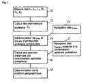
Fig. 1 : montre un organigramme d'un mode de réalisation préféré du procédé selon l'invention.
-
Fig. 1 shows a flowchart of a preferred embodiment of the method according to the invention.
Pour chaque satellite visible depuis le récepteur, c.-à-d. pour chaque satellite au-dessus de l'horizon au lieu géographique du récepteur, on a au niveau de ce dernier (à l'étape 10 de la
On utilisera en outre les notations suivantes : 
Les équations de modélisation des mesures de code et de phase (sans sauts de phase, mesures à gauche, modèles à droite) sont les suivantes : 
où
- D 1 et D 2 représentent les distances de propagation entre centres de phase, hors effets ionosphériques ;
- W la rotation de phase en fonction de l'orientation de la direction de propagation par rapport au dipôle de l'antenne (effet « windup ») ;
- e l'allongement ionosphérique à la fréquence f1 ;
- Δh = hrec - heme, la différence entre l'horloge du récepteur hrec et celle de l'émetteur heme à chaque date ;
- Δτ12 la différence des biais inter-code entre récepteur et émetteur à chaque date ;
- Δτ1, Δτ2 les biais code-phase (différences entre le récepteur et l'émetteur à chaque date) pour f1 et f2, respectivement ; et
- N1, N2 les ambiguïtés de phase entières des deux porteuses, inconnues au départ et supposées invariantes au cours d'un passage donné du satellite considéré (c.-à-d. que l'on comptabilise les sauts de phase qui surviennent pendant un passage du satellite dans les mesures de phase L1 et L2).
or
- D 1 and D 2 represent propagation distances between phase centers, excluding ionospheric effects;
- W phase rotation as a function of the orientation of the direction of propagation relative to the dipole of the antenna ("windup"effect);
- e the ionospheric elongation at the frequency f 1 ;
- Δ h = h rec - h eme , the difference between the receiver clock h rec and that of the emitter h eme at each date;
- Δτ 12 the difference in inter-code biases between receiver and transmitter at each date;
- Δτ 1 , Δτ 2 the code-phase biases (differences between the receiver and the transmitter at each date) for f 1 and f 2 , respectively; and
- N 1 , N 2 are the entire phase ambiguities of the two carriers, unknown at first and assumed to be invariant during a given passage of the satellite in question (ie, the phase hops that occur during a passage of the satellite in the phase measurements L 1 and L 2 ).
On note que les biais Δτ12, Δτ1, Δτ2 peuvent varier en fonction du temps.It is noted that the bias Δτ 12 , Δτ 1 , Δτ 2 may vary with time.
Notons ici qu'en cas de réception tri-fréquence, on a en outre, pour chaque satellite, la mesure de code P3 et la mesure de phase L3 à la troisième fréquence f3 ainsi que les équations de modélisation suivantes : 
où 
- N3 représente l'ambiguïté de phase entière de la troisième porteuse, inconnue au départ et supposée invariante au cours d'un passage donné du satellite considéré ;
- D3 la distance de propagation entre centres de phase, hors effets ionosphériques ; et
- Δτ13 la différence des biais inter-code entre récepteur et émetteur à chaque date pour les fréquences f1 et f3
- Δτ3 le biais code-phase pour f3.
or
- N 3 represents the entire phase ambiguity of the third carrier, unknown at first and supposedly invariant during a given passage of the satellite in question;
- D 3 the propagation distance between phase centers, excluding ionospheric effects; and
- Δτ 13 the difference of the inter-code biases between receiver and transmitter at each date for the frequencies f 1 and f 3
- Δτ 3 the phase-code bias for f 3 .
Comme les équations pour la paire de fréquences (f1, f3) s'obtiennent directement des équations pour la paire (f1, f2) par échange de l'indice « 2 » par l'indice « 3 », nous limiterons la discussion qui suivra à la paire de fréquences (f1, f2) afin d'éviter des répétitions inutiles.As the equations for the frequency pair (f 1 , f 3 ) are obtained directly from the equations for the pair (f 1 , f 2 ) by exchange of the index "2" by the index "3", we will limit the discussion that will follow at the pair of frequencies (f 1 , f 2 ) in order to avoid unnecessary repetitions.
L'ambiguïté widelane (entière) est définie par NW=N2-N1. On peut construire l'estimateur widelane pour NW (étape 12) par les équations suivantes : 


N̂w = N̂1 - N̂2 (estimation de l'ambiguïté widelane)The ambiguity widelane (integer) is defined by N W = N 2 -N 1 . The widelane estimator for N W (step 12) can be constructed by the following equations:
N w = N 1 - N 2 (estimation of ambiguity widelane)
On peut construire les équations de mesure de cet estimateur à partir des équations (1), et on obtient une équation de la forme : ![]()
où d est une correction géométrique liée à l'écart entre D1 et D2 qui reste petite devant un cycle pour les antennes courantes et peut se calculer avec une bonne précision si nécessaire à l'aide des éphémérides radiodiffusées. W ne contribue plus dans cette équation. Δµ est une combinaison linéaire des différences récepteur-émetteur Δτ12, Δτ1, Δτ2 et est donc aussi une différence entre une valeur ne dépendant que du récepteur (notée µ rec ) et une valeur ne dépendant que de l'émetteur (notée µ eme ). On note : ![]()
où la dépendance du temps est indiquée explicitement.We can construct the measurement equations of this estimator from equations (1), and we obtain an equation of the form: ![]()
where d is a geometric correction related to the difference between D 1 and D 2 which remains small in front of a cycle for current antennas and can be calculated with a good precision if necessary using the broadcast ephemeris. W no longer contributes to this equation. Δμ is a linear combination of receiver-transmitter differences Δτ 12 , Δτ 1 , Δτ 2 and is therefore also a difference between a value dependent only on the receiver (denoted μ rec ) and a value dependent only on the transmitter (denoted μ eme ). We notice : ![]()
where the dependence of time is explicitly indicated.
La valeur de Δµ est commune à toutes les mesures effectuées à une même date sur les différents canaux du récepteur.The value of Δμ is common to all measurements made at the same date on the different channels of the receiver.
La valeur de NW=N2-N1 peut être identifiée par résolution de l'équation (2) sur une certaine durée pendant laquelle on dispose au moins de deux passages simultanés de satellites (étape 14). En notant Kk l'entier à trouver, on peut reformuler l'équation (2) comme suit : ![]()
où
- Rk(t) représente le résidu associé à chaque mesure du passage k, sachant que d'après (2), on a Rk(t) = N̂W(t) -d(t).
- µe me,k(t) le biais widelane du satellite du passage k devant être fourni au récepteur pour déterminer la position (étape 13), et
- µ rec(t) le biais widelane du récepteur (inconnu, donc à déterminer lors de la recherche de Kk).
or
- R k (t) represents the residue associated with each measure of the passage k, knowing that according to (2), we have R k (t) = N W (t) -d (t).
- μ e me, k (t) the widelane bias of the satellite of the passage k to be supplied to the receiver to determine the position (step 13), and
- μ rec (t) the widelane bias of the receiver (unknown, therefore to be determined during the search for K k ).
On note que l'équation (4) représente en fait un système d'équations, qui peut être résolu, par exemple, par la technique des moindres carrés. Cette méthode de résolution n'est pas détaillée ici. Il est important de noter que la solution du système (4) n'est pas unique, mais qu'il y a une famille de solutions qui se déduisent les unes des autres par la transformation entière [µrec(t),Kk]↔[µrec(t)+n,Kk-n], pour tout n entier.Note that equation (4) actually represents a system of equations, which can be solved, for example, by the least squares technique. This method of resolution is not detailed here. It is important to note that the solution of the system (4) is not unique, but that there is a family of solutions that are deduced from each other by the entire transformation [μ rec (t), K k ] ↔ [μ rec (t) + n, K k -n], for all n integer.
Une autre possibilité simple de résolution du système (4), et qui se prête bien à l'illustration du concept, est la construction de simples différences entre mesures associées à différents passages, ce qui permet d'éliminer directement la contribution de µrec(t) et d'obtenir des équations de la forme : ![]()
![]()
Les valeurs µeme méritent une explication, car sans connaissance de ces valeurs, le récepteur ne saura pas accéder à la solution cohérente des ambiguïtés widelane. Les valeurs µeme sont déterminées de préférence au niveau d'un réseau de récepteurs de référence. On utilise la propriété que, dans la pratique, les µeme sont des fonctions lentement variables du temps. La technique de détermination des µeme au niveau d'un réseau de référence a fait l'objet de la demande de brevet enregistrée sous le numéro
Pour les satellites dont on connaît maintenant les délais internes µeme on estime les délais µrec,ref des autres stations. Cette fois-ci, dans l'équation Rk (t) = Kk + µ rec,ref (t) - µ eme.k (t), la valeur de µeme,k est connue. On décompose alors Rk (t) +µ eme,k (t) en un nombre entier arbitraire (de la nouvelle station) et le délai de station µrec,ref correspondant. On répète ces étapes pour tous les satellites de la constellation et toutes les stations du réseau de référence. On obtient finalement des valeurs µeme cohérentes sur tout le réseau de référence, qui peuvent être considérées comme constantes sur au moins une journée.For satellites which are now known the internal delays μ eme is estimated delays μ rec, ref of all stations. This time, in the equation R k ( t ) = K k + μ rec, ref ( t ) - μ eme.k ( t ) , the value of μ eme, k is known. R k ( t ) + μ e me, k ( t ) is then decomposed into an arbitrary integer (of the new station) and the corresponding station delay μ rec, ref . These steps are repeated for all satellites in the constellation and all stations in the reference network. Finally, we obtain coherent μem values over the entire reference network, which can be considered constant over at least one day.
Les µeme peuvent être communiqués au récepteur devant déterminer sa position par tout moyen convenable, par exemple dans le message de navigation de la constellation de satellites considérée, par diffusion terrestre ou à partir d'un satellite SBAS, par Intenet, par radiotéléphonie mobile, etc. Etant donné le faible taux de changement des µeme, peu de bande passante est nécessaire pour acheminer leurs valeurs au récepteur devant fixer sa position.The μ eme can be communicated to the receiver to determine its position by any suitable means, for example in the navigation message of the satellite constellation considered, by terrestrial broadcasting or from an SBAS satellite, by Intenet, by mobile radiotelephony, etc. Given the low rate of change of μ th, little bandwidth is needed to get their values to the receiver to fix its position.
Lorsque la valeur de l'ambiguïté widelane est connue, on peut construire à partir des équations de phase dans (1), une nouvelle équation, homogène à une pseudo-distance : 
où Δτ w est une grandeur similaire à un TGD (de « time group delay »), car c'est une combinaison linéaire de Δτ12, Δτ1, Δτ2. Cette nouvelle combinaison a un bruit de mesure très intéressant valant un peu moins de deux fois le bruit de phase (donc typiquement 5 mm), à comparer avec le bruit de code (typiquement de quelques dizaines de centimètres).When the value of the ambiguity widelane is known, one can build from the equations of phase in (1), a new equation, homogeneous with a pseudo-distance:
where Δτ w is a size similar to a TGD (time group delay) because it is a linear combination of Δτ 12 , Δτ 1 , Δτ 2 . This new combination has a very interesting measurement noise worth a little less than twice the phase noise (so typically 5 mm), to compare with the code noise (typically a few tens of centimeters).
On dispose des mesures non ambiguës suivantes (après blocage de la combinaison widelane, en notation classique Rinex, jeu de mesures à une date): 
où D et e sont respectivement la pseudo-distance modélisable (y compris l'allongement troposphérique), et l'allongement ionosphérique sur la première fréquence. Δh est ici la différence entre horloge récepteur et horloge émetteur, référencée à la combinaison de pseudo-distances « iono-free » (sans contribution ionosphérique) (γP1-P2)/(γ - 1) ; Δτ correspond ici au 'TGD' entre récepteur et émetteur, car les équations sont référencées à la combinaison iono-free, contrairement aux équations (1). Ceci ne change pas la généralité, mais référence les équations (6) relativement à ce qui est habituellement utilisé dans le système GPS.The following unambiguous measures are available (after blocking the widelane combination, in classical Rinex notation, a set of measurements on a date):
where D and e are respectively the modelizable pseudo-distance (including the tropospheric elongation), and the ionospheric elongation on the first frequency. Δ h is here the difference between receiver clock and transmitter clock, referenced to the combination of pseudo-distances "iono-free" (without ionospheric contribution) (γP 1 -P 2 ) / (γ-1); Δτ here corresponds to the 'TGD' between receiver and transmitter, because the equations are referenced to the iono- free combination, unlike equations (1). This does not change the generality, but refers equations (6) to what is usually used in the GPS system.
L'équation de l'observable widelane est particulière parce que l'ensemble des ambiguïtés widelane est déterminé à un entier près (noté n).The equation of the observable widelane is particular because the set of ambiguities widelane is determined to an integer (denoted n).
On a négligé les contributions de corrections telles que l'écart des centres de phase, sachant que l'objectif est ici d'analyser les bruits de combinaisons idéales. De toute façon, on peut toujours supposer que ces corrections ont été appliquées avant la génération des équations ci-dessus, car ces corrections sont calculables au niveau récepteur avec une précision suffisante. L'effet windup (qui nécessiterait la connaissance ou la modélisation de l'attitude des satellites) n'a pas à être pris en compte, car il est éliminé dans la combinaison widelane (voir équation (5)).We have neglected the contributions of corrections such as the gap of the phase centers, knowing that the objective here is to analyze the noise of ideal combinations. Anyway, one can always assume that these corrections were applied before the generation of the equations above, because these corrections are calculable at the receiver level with a sufficient precision. The windup effect (which would require the knowledge or the modeling of the attitude of the satellites) does not have to be taken into account, because it is eliminated in the widelane combination (see equation (5)).
Dans le cas de trois observables, on dispose donc de trois coefficients pour construire une combinaison des équations (6) éliminant le terme ionosphérique (étape 16). En notant Popt la combinaison optimale des observables des équations (6) et aw, a1 et a2 les coefficients de cette combinaison, on obtient : ![]()

![]()
Il y a deux équations de contrainte, donc il reste une infinité de combinaisons possibles, parmi lesquelles on peut choisir avec un critère supplémentaire tel que la minimisation du bruit ou la robustesse des résultats.There are two constraint equations, so there is an infinity of possible combinations, among which we can choose with an additional criterion such as the noise minimization or the robustness of the results.
Tous les termes d'horloge ainsi que les termes Δτ et Δτw des équations (6) se regroupent en un terme que l'on peut appeler « horloge associée à la combinaison » dans le cadre de l'utilisation d'une combinaison donnée de ces observables. Ce terme d'horloge est noté Δhopt et on a alors Popt = D+ Δhopt. On remarque que la partie horloge récepteur du terme Δhopt est ambiguë (à cause de l'entier inconnu n), mais cela ne limite pas la résolution d'un problème de positionnement, puisque dans ce cas, l'horloge récepteur est supposée inconnue et est résolue à chaque date. Pour déduire la pseudo-distance D de la combinaison Popt (étape 16), le récepteur a besoin de connaître la partie horloge émetteur du terme Δhopt, que l'on notera hopt,eme. Les valeurs des hopt,eme sont de préférence calculées au niveau d'un système de référence et transmises au récepteur (étape 15). La détermination de la position géographique du récepteur (étape 18) se fait finalement grâce aux jeu de pseudo-distances calculées. On note que la combinaison qui est utilisée dans le récepteur doit être fixée à l'avance (par exemple par convention, ou par définition d'un protocole) pour que les valeurs hopt,eme soient consistantes avec la combinaison. La détermination des hopt,eme peut se faire de façon classique au niveau du réseau de référence grâce au système d'équations (6). Notons qu'au niveau du réseau de référence, les positions des récepteurs de référence (donc aussi le pseudo-distances) étant connus, le système (6) est alors résolu pour les inconnues hopt,eme, hopt,rec etc.All clock terms and the terms Δτ and Δτ w of equations (6) are grouped into a term that may be termed "combination clock" in the context of using a given combination of these observables. This clock term is denoted Δ h opt and then we have P opt = D + Δh opt . Note that the receiver clock part of the term Δ h opt is ambiguous (because of the unknown integer n), but this does not limit the resolution of a positioning problem, since in this case, the receiver clock is assumed unknown and is resolved on each date. To deduce the pseudo-distance D from the combination P opt (step 16), the receiver needs know the emitting clock part of the term Δ h opt , which will be noted h opt, eme . The h opt values are preferably calculated at a reference system and transmitted to the receiver (step 15). The determination of the geographical position of the receiver (step 18) is finally done thanks to the set of calculated pseudo-distances. Note that the combination that is used in the receiver must be set in advance (for example by convention, or by definition of a protocol) so that the values h opt, eme are consistent with the combination. The determination of h opt, eme can be done conventionally at the level of the reference network through the system of equations (6). Note that at the reference network, the positions of the reference receivers (thus also the pseudo-distances) being known, the system (6) is then solved for the unknowns h opt, eme , h opt, rec etc.
La formulation théorique du problème de la construction des combinaisons linéaires de plusieurs observables éliminant l'effet ionosphérique est détaillée ci-dessous. Elle se généralise directement à un nombre quelconque d'observables.The theoretical formulation of the problem of constructing linear combinations of several observables eliminating the ionospheric effect is detailed below. It is generalized directly to any number of observables.
On note x le vecteur des coefficients de la combinaison des trois observables (widelane, code 1 et code 2), A et B les matrices des coefficients des équations (6), de façon à avoir : 
![]()
![]()
On obtient D par : 
En notant P la matrice de corrélation des bruits des quatre mesures brutes code et phase, le bruit correspondant à cette solution est donné par ![]()
![]()
Pour chaque définition des bruits P, on peut ainsi trouver les coefficients de la combinaison optimale x et le bruit sur la solution (c.-à-d. sur la valeur de D) associée. Dans la suite, nous allons illustrer l'ordre de grandeur des bruits optimums pour différents cas de bruits de mesure.For each definition of the noise P, it is thus possible to find the coefficients of the optimal combination x and the noise on the solution (that is to say on the value of D) associated. In the following, we will illustrate the order of magnitude of the optimum noise for different cases of measurement noise.
Le tableau ci-dessous montre l'ordre de grandeur des bruits optimums dans le cas de GPS en mode bi-fréquence (unités en mètres, fréquences 1 et 2 respectivement de 1575,42 MHz et 1227,60 MHz) :
La première ligne de ce tableau (bruits phase supposés infinis) correspond au cas classique de la combinaison iono-free de code. On remarque que l'utilisation de la combinaison de phase widelane n'est intéressante que si au moins une des mesures de code a un bruit faible. Or, les trois dernières lignes du tableau sont des cas hypothétiques, car le bruit des mesures de code des signaux GPS est de l'ordre du mètre. On voit aussi que si on suppose que les deux mesures de code ont un bruit de 10 cm, on arrive à un bruit de 30 cm sur la combinaison iono-free de code, ce qui montre que l'apport de la combinaison de phase widelane n'est pas significatif si les deux mesures de code sont bonnes (dernière ligne du tableau). A titre indicatif, si on effectuait une résolution complète des ambiguïtés, le bruit résultant serait de 3 cm, avec les hypothèses retenues.The first line of this table (supposedly infinite phase noise) corresponds to the classical case of the iono-free combination of code. Note that the use of the widelane phase combination is only interesting if at least one of the code measurements has a low noise. However, the last three lines of the table are hypothetical cases, because the noise of the GPS signal code measurements is of the order of one meter. We also see that if we assume that the two measures of code have a noise of 10 cm, we arrive at a noise of 30 cm on the iono-free combination of code, which shows that the contribution of the combination of phase widelane is not significant if both code measures are good (last line of the table). As an indication, if we carried out a complete resolution of the ambiguities, the resulting noise would be 3 cm, with the assumptions retained.
Pour le cas GPS tri-fréquence, on disposera des fréquences L1, L2 et L5. On peut alors adapter les systèmes d'équations (6)-(11) et on arrive au tableau de bruits suivant (unités de nouveau en mètres, fréquences 1, 2 et 3 de 1575,42 MHz, 1227,60 MHz et 1176,45 MHz, respectivement) :
Le comportement est cohérent avec celui de l'exemple 1 : ce sont les deux combinaisons les moins bruitées qui contribuent essentiellement à la performance. La première ligne du tableau montre que l'ajout de la troisième fréquence n'apporte pas grand-chose au bruit résultant obtenue par la combinaison iono-free de code (ce qui ne diminue pas l'intérêt de trois fréquences, pour des raisons de robustesse, multi-trajets, etc.).The behavior is consistent with that of Example 1: it is the two less noisy combinations that contribute essentially to the performance. The first line of the table shows that the addition of the third frequency does not add much to the resulting noise obtained by the iono-free combination of code (which does not diminish the interest of three frequencies, for reasons of robustness, multipath, etc.).
Par contre, on a directement une performance de 27 cm si on utilise uniquement les mesures de phase en combinaisons widelane (deuxième ligne du tableau). Ensuite, une mesure de code de très bonne qualité permettrait de gagner un peu en termes de bruit résultant. Ensuite, une réduction du bruit sur les autres mesures de code n'apporterait qu'une amélioration marginale au bruit résultant.On the other hand, we have a performance of 27 cm directly if we use only the phase measurements in widelane combinations (second line of the table). Then, a code measurement of very good quality would save a little in terms of the resulting noise. Then, noise reduction on the other code measurements would only marginally improve the resulting noise.
Par rapport au cas standard (combinaison iono-free de code) on a donc un gain de facteur 10 en bruit en utilisant les combinaisons de phase widelane, et un faible gain supplémentaire en rajoutant une mesure de code plus performante. L'intérêt des combinaisons de phase widelane vient du fait que les données ne dépendent que de la phase et sont ainsi moins sujettes à des problèmes de multi-trajets que les mesures de code.Compared to the standard case (iono-free combination of code) we have a factor gain of 10 in noise using the phase combinations widelane, and a small additional gain by adding a more powerful code measure. The advantage of the widelane phase combinations is that the data depend only on the phase and are thus less subject to multipath problems than the code measurements.
On répète l'analyse des performances pour le cas du futur système Galileo. Les fréquences 1, 2 et 3 utilisées dans le tableau suivant sont donc maintenant 1575,42 MHz, 1176,45 MHz et 1278,75 MHz, respectivement.
Comme pour GPS tri-fréquence, l'apport significatif provient des deux combinaisons de phase widelane. On gagne ici plus d'un facteur 10 sur le bruit résultant.As for tri-frequency GPS, the significant contribution comes from the two combinations of phase widelane. Here we gain more than a
Les exemples qui précèdent montrent que grâce à l'utilisation des ambiguïtés widelane cohérentes dans un récepteur tri-fréquence il est possible des construire une pseudo-distance iono-free dont le bruit est amélioré d'un facteur 10 par rapport à la pseudo-distance iono-free obtenue par combinaisons de mesures de code uniquement.The preceding examples show that, thanks to the use of coherent widelane ambiguities in a tri-frequency receiver, it is possible to construct a pseudo-distance iono-free whose noise is improved by a factor of 10 with respect to the pseudo-distance iono-free obtained by combinations of code measurements only.
L'utilisation de cette capacité repose sur la disponibilité, au niveau du récepteur, de différentes données, à savoir les biais widelane des satellites (les valeurs des µeme(t)) ainsi que des données horloges de satellites associées à la combinaison optimale utilisée au niveau du récepteur. Les biais widelane µeme sont calculés pour la ou les combinaisons widelane utilisées et pour tous les satellites de la constellation au niveau d'un système de référence. D'autre part, le système de référence détermine les horloges hopt,eme pour la combinaison optimale choisie et aux éphémérides dont dispose le récepteur devant fixer sa position. De préférence, les données dont le récepteur a besoin sont communiquées régulièrement depuis le système de référence selon un protocole prédéfini. En principe, toutes les voies de communication pourront être utilisées, à condition que leur bande passante convienne. Le récepteur possède de préférence une mémoire pour y stocker les données communiquées par le système de référence entre les différentes mises à jour.The use of this capability is based on the availability, at the receiver, of different data, namely the widelane biases of the satellites (the values of the μ eme (t)) as well as the satellite clock data associated with the optimal combination used. at the receiver. The widelane μ eme biases are calculated for the widelane combination (s) used and for all satellites of the constellation at a reference system level. On the other hand, the reference system determines the clocks h opt, eme for the optimal combination chosen and the ephemeris available to the receiver to fix its position. Preferably, the data which the receiver needs are communicated regularly from the reference system according to a predefined protocol. In principle, all communication channels can be used, provided that their bandwidth is suitable. The receiver preferably has a memory for storing the data communicated by the reference system between the different updates.
Il n'est en théorie pas nécessaire de disposer de nouvelles éphémérides pour utiliser le procédé selon l'invention, c.-à-d. que l'on pourrait utiliser les éphémérides standard diffusées par les satellites dans le message de navigation. Toutefois, on note d'une part que leur performance va limiter l'intérêt de la méthode, d'autre part que les horloges associées à la combinaison optimale devraient alors être calculées à partir de ces éphémérides. Pour que l'utilisateur puisse pleinement bénéficier de la performance du procédé (typiquement pour avoir mieux que 10 centimètres de précision sur la mesure), on prévoit donc de préférence une mise à jour d'éphémérides plus précise.In theory, it is not necessary to have new ephemeris to use the method according to the invention, that is to say that the standard ephemeris broadcast by the satellites could be used in the navigation message. However, we note on the one hand that their performance will limit the interest of the method, on the other hand that the clocks associated with the optimal combination should then be calculated from these ephemeris. So that the user can fully benefit from the performance of the process (typically to have better than 10 cm accuracy on the measurement), it is therefore preferably provided a more accurate ephemeris update.
D'autre part, une diffusion des horloges correspondant à la combinaison utilisée est nécessaire dans le cas général. Cependant, ces horloges pourraient aussi être obtenues par une correction par rapport à des horloges de référence (de façon similaire au biais inter-fréquence ('TGD') de GPS, qui permet d'obtenir des horloges adaptées à la première fréquence à partir des horloges de référence issues de la combinaison iono-free). Dans la plupart des cas, ces corrections seront constantes ou lentement variables. La méthode est donc compatible avec des horloges plus précises, obtenues par exemple par blocage complet des ambiguïtés entières au niveau système.On the other hand, a broadcast of the clocks corresponding to the combination used is necessary in the general case. However, these clocks could also be obtained by a correction relative to reference clocks (in a similar way to the inter-frequency bias ('TGD') of GPS, which makes it possible to obtain clocks adapted to the first frequency from the reference clocks from the iono-free combination). In most cases, these corrections will be constant or slowly variable. The method is therefore compatible with more precise clocks, obtained for example by completely blocking entire ambiguities at the system level.
Claims (11)
- Method for treating radionavigation signals that originate from a group of satellites, in which each satellite broadcasts at least a first radionavigation signal on a first frequency and a second radionavigation signal on a second frequency that is different from the first, said method comprising,
at the level of a receiver, the actions of:a) receiving, for each satellite of said group, said first and second signals;b) executing, for each satellite of said group, the non-differentiated measurements of code and phase of said first and second received signals (10), said measurement of phase of the first signal and said measurement of phase of the second signal each having an a priori unknown integer ambiguity, such that the widelane combination of the measurements of phase of the first and second signals also has an a priori unknown first widelane integer ambiguity;c) determining the first widelane ambiguities in a coherent manner for the group of satellites by using widelane biases, received from a reference system, associated with the satellites of said group of satellites (12, 13, 14), andd) fixing the position of the receiver (18) with the help of said measurements of code and phase of the first and second received signals as well as of the first widelane ambiguities determined in a coherent manner on the group of satellites,characterised in that
the action of fixing the position of the receiver comprises, for each satellite of said group of satellites, the determination (16) of a pseudo distance by means of an ionosphere-free combination of said measurements of code and of the difference of the measurements of phase of the first and second signals, compensated by the widelane ambiguity, said combination being optimised in terms of noise, the determination of the pseudo distance also depending on the satellite clock values, received from a reference system, associated with said ionosphere-free combination. - Method according to claim 1, wherein the determination of the first widelane ambiguities in a coherent manner on the group of satellites comprises:receiving widelane biases associated with the satellites of said group of satellites from a reference system (13);for each satellite of the group of satellites, calculation of an estimated value for the first widelane ambiguity (12) according to the equation:

where N̂w, designates said estimated value of the first widelane ambiguity,
P1 and P2 designate the measurements of code of the first and second signals, respectively,
L1 and L2 designate the measurements of phase of the first and second signals, respectively,
λ1 and λ2 designate the wavelengths of the first and second signals, respectively, for each satellite of said group of satellites, establishment of a model for the first widelane ambiguity by
d designates a geometric correction term,
µsat designates the widelene bias associated with the respective satellite,
µrec designates the widelane bias associated with the receiver, common to all the first widelane ambiguities;and identifying a set of integer values of the first widelane ambiguities that conform to said model for the group of satellites (14). - Method according to claim 2, wherein the identification of said integer values (14) is accomplished with the help of simple differences between satellites from the models of the first widelane ambiguities.
- Method according to any one of claims 1 to 3, wherein said first and second frequencies are selected among the frequencies L1, L2, L5 and E6.
- Method according to any one of claims 1 to 4, wherein each satellite of said group broadcasts a third radionavigation signal on a third frequency distinct from the first and second frequencies,
wherein,
for each satellite of said group, said third signal is also received;
the non-differentiated measurements of code and phase of said third received signals are executed for each satellite of said group, said measurement of phase of the third signal having an a priori unknown integer ambiguity, such that the widelane combination of the measurements of phase of the first and third signals has a second a priori unknown widelane integer ambiguity;
the second widelane ambiguities are determined in a coherent manner on the group of satellites, and
the action of fixing the position of the receiver is made with the help of the measurements of code and phase of the third signals as well as the second widelane ambiguities determined in a coherent manner on the group of satellites. - Method according to claim 5, wherein the determination of the second widelane ambiguities in a coherent manner on the group of satellites is effected in an analogous manner to the determination of the first widelane ambiguities in a coherent manner on the group of satellites.
- Method according to claim 5 or 6, wherein said third frequency is selected among the frequencies L1, L2, L5 and E6.
- Method according to any one of claims 1 to 7, wherein among said non-differentiated measurements of code at least one has a noise less than 0.5 m, preferably less than 0.25 m.
- Method according to any one of claims 5 to 7, wherein each of said non-differentiated measurements of code has a noise greater than 0.5 m.
- GNSS receiver, characterised by the means configured for implementing the method according to any one of claims 1 to 9.
- GNSS receiver according to claim 10, the means for implementing the method comprising a program, stored in a memory of the receiver, set up in such a way to operate the receiver according to the method when the program is executed in the receiver.
Priority Applications (1)
| Application Number | Priority Date | Filing Date | Title |
|---|---|---|---|
| PL09815671T PL2335085T3 (en) | 2008-09-23 | 2009-09-21 | Processing of radionavigation signals using a wide-lane combination |
Applications Claiming Priority (2)
| Application Number | Priority Date | Filing Date | Title |
|---|---|---|---|
| FR0856378A FR2936320B1 (en) | 2008-09-23 | 2008-09-23 | RADIONAVIGATION SIGNAL PROCESSING USING A WIDELANE COMBINATION |
| PCT/EP2009/062217 WO2010034694A1 (en) | 2008-09-23 | 2009-09-21 | Processing of radionavigation signals using a wide-lane combination |
Publications (2)
| Publication Number | Publication Date |
|---|---|
| EP2335085A1 EP2335085A1 (en) | 2011-06-22 |
| EP2335085B1 true EP2335085B1 (en) | 2012-12-26 |
Family
ID=40723231
Family Applications (1)
| Application Number | Title | Priority Date | Filing Date |
|---|---|---|---|
| EP09815671A Active EP2335085B1 (en) | 2008-09-23 | 2009-09-21 | Processing of radionavigation signals using a wide-lane combination |
Country Status (14)
| Country | Link |
|---|---|
| US (1) | US8760344B2 (en) |
| EP (1) | EP2335085B1 (en) |
| JP (1) | JP5539990B2 (en) |
| KR (1) | KR101605390B1 (en) |
| CN (1) | CN102165329B (en) |
| AU (1) | AU2009296004B2 (en) |
| BR (1) | BRPI0913798A2 (en) |
| CA (1) | CA2736917C (en) |
| ES (1) | ES2401734T3 (en) |
| FR (1) | FR2936320B1 (en) |
| PL (1) | PL2335085T3 (en) |
| RU (1) | RU2487371C2 (en) |
| TW (1) | TWI442080B (en) |
| WO (1) | WO2010034694A1 (en) |
Cited By (2)
| Publication number | Priority date | Publication date | Assignee | Title |
|---|---|---|---|---|
| WO2015049383A1 (en) | 2013-10-04 | 2015-04-09 | Centre National D'etudes Spatiales | Agricultural machine for revisiting a planted plot; associated method |
| US10732295B2 (en) | 2014-07-17 | 2020-08-04 | Centre National D'etudes Spatiales | Positioning and navigation receiver with a confidence index |
Families Citing this family (13)
| Publication number | Priority date | Publication date | Assignee | Title |
|---|---|---|---|---|
| JP5965765B2 (en) * | 2012-07-25 | 2016-08-10 | ライトハウステクノロジー・アンド・コンサルティング株式会社 | Satellite positioning signal receiving method and apparatus |
| NL2009695C2 (en) | 2012-10-25 | 2014-05-06 | Fugro N V | Ppp-rtk method and system for gnss signal based position determination. |
| US10371820B2 (en) | 2014-03-28 | 2019-08-06 | Mitsubishi Electric Corporation | Positioning device |
| WO2015145719A1 (en) * | 2014-03-28 | 2015-10-01 | 三菱電機株式会社 | Positioning device |
| US9923626B2 (en) * | 2014-06-13 | 2018-03-20 | Trimble Inc. | Mobile ionospheric data capture system |
| CN104483690B (en) * | 2015-01-05 | 2017-05-31 | 中国科学院重庆绿色智能技术研究院 | A kind of frequency Static Precise Point Positioning fuzziness fixing means of GNSS tri- |
| EP3109672B1 (en) | 2015-06-24 | 2018-12-12 | Centre National d'Etudes Spatiales | Gnss receiver with a capability to resolve ambiguities using an uncombined formulation |
| US10564293B2 (en) * | 2016-03-18 | 2020-02-18 | Deere & Company | Navigation satellite orbit and low latency clock determination with wide-lane and narrow-lane bias corrections |
| US10564294B2 (en) * | 2016-03-18 | 2020-02-18 | Deere & Company | Navigation satellite wide-lane bias determination and over-range adjustment system and method |
| US10381748B2 (en) * | 2016-03-29 | 2019-08-13 | Space Systems/Loral, Llc | Satellite system with handover for multiple gateways |
| WO2019026374A1 (en) * | 2017-08-04 | 2019-02-07 | ソニー株式会社 | Communication device, information processing device, and information processing method |
| CN111650608B (en) * | 2020-06-15 | 2023-01-10 | 中国人民解放军61540部队 | Method and system for eliminating ionospheric errors by Ka/C dual-frequency altimeter |
| CN111551975B (en) * | 2020-06-24 | 2023-05-09 | 辽宁工程技术大学 | BDS/GPS reference station low altitude angle satellite whole-cycle ambiguity determining method |
Family Cites Families (13)
| Publication number | Priority date | Publication date | Assignee | Title |
|---|---|---|---|---|
| RU2092902C1 (en) * | 1993-12-27 | 1997-10-10 | Российский научно-исследовательский институт космического приборостроения | Method for detection of position of vehicle and device which implements said method |
| KR100295827B1 (en) | 1997-12-31 | 2002-05-01 | 박종섭 | Position tracking method of gps receiver |
| US6735523B1 (en) * | 2000-06-19 | 2004-05-11 | American Gnc Corp. | Process and system of coupled real-time GPS/IMU simulation with differential GPS |
| CN1267745C (en) * | 2002-06-26 | 2006-08-02 | 中国科学院武汉物理与数学研究所 | Whole cycle fuzziness initializing method in short-base line DGPS location |
| US7117417B2 (en) * | 2003-07-30 | 2006-10-03 | Navcom Technology, Inc. | Method for generating clock corrections for a wide-area or global differential GPS system |
| JP4723801B2 (en) * | 2003-08-25 | 2011-07-13 | 古野電気株式会社 | Relative positioning device |
| CN1332214C (en) * | 2003-09-18 | 2007-08-15 | 电子科技大学 | Method for determining full round number funiness of radio guidance system |
| US6934632B2 (en) * | 2003-10-08 | 2005-08-23 | Navcom Technology, Inc. | Method for using three GPS frequencies to resolve carrier-phase integer ambiguities |
| EP1724605A1 (en) | 2005-05-18 | 2006-11-22 | Leica Geosystems AG | Method of determining position for a satellite based positioning system |
| JP5301762B2 (en) * | 2005-10-07 | 2013-09-25 | 古野電気株式会社 | Carrier phase relative positioning device |
| JP4928114B2 (en) * | 2005-11-07 | 2012-05-09 | 古野電気株式会社 | Carrier phase relative positioning device |
| US7633437B2 (en) * | 2006-09-22 | 2009-12-15 | Navcom Technology, Inc. | Method for using three GPS frequencies to resolve whole-cycle carrier-phase ambiguities |
| CN101216549B (en) * | 2008-01-11 | 2010-04-21 | 哈尔滨工程大学 | Medium-high frequency wave spread-spectrum navigation system distance observed quantity extraction method |
-
2008
- 2008-09-23 FR FR0856378A patent/FR2936320B1/en not_active Expired - Fee Related
-
2009
- 2009-09-21 EP EP09815671A patent/EP2335085B1/en active Active
- 2009-09-21 RU RU2011115869/07A patent/RU2487371C2/en not_active IP Right Cessation
- 2009-09-21 US US13/119,638 patent/US8760344B2/en active Active
- 2009-09-21 ES ES09815671T patent/ES2401734T3/en active Active
- 2009-09-21 WO PCT/EP2009/062217 patent/WO2010034694A1/en active Application Filing
- 2009-09-21 BR BRPI0913798A patent/BRPI0913798A2/en not_active IP Right Cessation
- 2009-09-21 PL PL09815671T patent/PL2335085T3/en unknown
- 2009-09-21 CA CA2736917A patent/CA2736917C/en not_active Expired - Fee Related
- 2009-09-21 KR KR1020117009264A patent/KR101605390B1/en not_active IP Right Cessation
- 2009-09-21 AU AU2009296004A patent/AU2009296004B2/en not_active Ceased
- 2009-09-21 CN CN2009801373124A patent/CN102165329B/en active Active
- 2009-09-21 JP JP2011527349A patent/JP5539990B2/en not_active Expired - Fee Related
- 2009-09-23 TW TW098132222A patent/TWI442080B/en not_active IP Right Cessation
Cited By (2)
| Publication number | Priority date | Publication date | Assignee | Title |
|---|---|---|---|---|
| WO2015049383A1 (en) | 2013-10-04 | 2015-04-09 | Centre National D'etudes Spatiales | Agricultural machine for revisiting a planted plot; associated method |
| US10732295B2 (en) | 2014-07-17 | 2020-08-04 | Centre National D'etudes Spatiales | Positioning and navigation receiver with a confidence index |
Also Published As
| Publication number | Publication date |
|---|---|
| AU2009296004B2 (en) | 2014-04-17 |
| US8760344B2 (en) | 2014-06-24 |
| FR2936320B1 (en) | 2012-12-28 |
| RU2487371C2 (en) | 2013-07-10 |
| JP2012503191A (en) | 2012-02-02 |
| CN102165329B (en) | 2013-08-21 |
| PL2335085T3 (en) | 2013-05-31 |
| FR2936320A1 (en) | 2010-03-26 |
| KR20110082002A (en) | 2011-07-15 |
| JP5539990B2 (en) | 2014-07-02 |
| WO2010034694A1 (en) | 2010-04-01 |
| KR101605390B1 (en) | 2016-03-22 |
| TWI442080B (en) | 2014-06-21 |
| CA2736917A1 (en) | 2010-04-01 |
| ES2401734T3 (en) | 2013-04-24 |
| TW201013218A (en) | 2010-04-01 |
| US20110210888A1 (en) | 2011-09-01 |
| CA2736917C (en) | 2016-05-24 |
| AU2009296004A1 (en) | 2010-04-01 |
| CN102165329A (en) | 2011-08-24 |
| BRPI0913798A2 (en) | 2015-10-20 |
| EP2335085A1 (en) | 2011-06-22 |
| RU2011115869A (en) | 2012-10-27 |
Similar Documents
| Publication | Publication Date | Title |
|---|---|---|
| EP2335085B1 (en) | Processing of radionavigation signals using a wide-lane combination | |
| EP2140285B1 (en) | Method of processing radionavigation signals | |
| EP1836507B1 (en) | Positioning device and method | |
| JP2010522874A5 (en) | ||
| EP1724608A1 (en) | Transmission of a mobile's three-dimensional environment information | |
| CN116243591B (en) | Subnanosecond time service method integrating UTC (k) and Beidou broadcast ephemeris | |
| EP3223038A1 (en) | Satellite geopositioning method and associated terminal | |
| WO2005059583A1 (en) | Method of updating the clock bias between a bts station of a gsm network and the satellites of a gps system | |
| CA2754178C (en) | Geopositioning method using assistance data | |
| EP1560037A2 (en) | Method of factorisation of pseudorange dating in an assisted GNSS system | |
| FR3066027A1 (en) | GNSS POSITIONING METHOD | |
| EP4097420A1 (en) | Method and system for navigation | |
| EP1493041B1 (en) | Method and device for determining the relative position of two points | |
| EP1876465A1 (en) | Method of determining common navigation information for regions with different groups of satellite surveillance stations in a satellite navigation system | |
| CN114761831A (en) | Determining accurate position of stationary GNSS sensors |
Legal Events
| Date | Code | Title | Description |
|---|---|---|---|
| PUAI | Public reference made under article 153(3) epc to a published international application that has entered the european phase |
Free format text: ORIGINAL CODE: 0009012 |
|
| 17P | Request for examination filed |
Effective date: 20110407 |
|
| AK | Designated contracting states |
Kind code of ref document: A1 Designated state(s): AT BE BG CH CY CZ DE DK EE ES FI FR GB GR HR HU IE IS IT LI LT LU LV MC MK MT NL NO PL PT RO SE SI SK SM TR |
|
| AX | Request for extension of the european patent |
Extension state: AL BA RS |
|
| DAX | Request for extension of the european patent (deleted) | ||
| REG | Reference to a national code |
Ref country code: DE Ref legal event code: R079 Ref document number: 602009012343 Country of ref document: DE Free format text: PREVIOUS MAIN CLASS: G01S0001000000 Ipc: G01S0019440000 |
|
| GRAP | Despatch of communication of intention to grant a patent |
Free format text: ORIGINAL CODE: EPIDOSNIGR1 |
|
| RIC1 | Information provided on ipc code assigned before grant |
Ipc: G01S 19/44 20100101AFI20120418BHEP Ipc: G01S 19/07 20100101ALI20120418BHEP |
|
| GRAS | Grant fee paid |
Free format text: ORIGINAL CODE: EPIDOSNIGR3 |
|
| GRAP | Despatch of communication of intention to grant a patent |
Free format text: ORIGINAL CODE: EPIDOSNIGR1 |
|
| GRAA | (expected) grant |
Free format text: ORIGINAL CODE: 0009210 |
|
| AK | Designated contracting states |
Kind code of ref document: B1 Designated state(s): AT BE BG CH CY CZ DE DK EE ES FI FR GB GR HR HU IE IS IT LI LT LU LV MC MK MT NL NO PL PT RO SE SI SK SM TR |
|
| REG | Reference to a national code |
Ref country code: GB Ref legal event code: FG4D Free format text: NOT ENGLISH |
|
| REG | Reference to a national code |
Ref country code: CH Ref legal event code: EP |
|
| REG | Reference to a national code |
Ref country code: AT Ref legal event code: REF Ref document number: 590757 Country of ref document: AT Kind code of ref document: T Effective date: 20130115 |
|
| REG | Reference to a national code |
Ref country code: DE Ref legal event code: R096 Ref document number: 602009012343 Country of ref document: DE Effective date: 20130307 |
|
| REG | Reference to a national code |
Ref country code: ES Ref legal event code: FG2A Ref document number: 2401734 Country of ref document: ES Kind code of ref document: T3 Effective date: 20130424 |
|
| PG25 | Lapsed in a contracting state [announced via postgrant information from national office to epo] |
Ref country code: HR Free format text: LAPSE BECAUSE OF FAILURE TO SUBMIT A TRANSLATION OF THE DESCRIPTION OR TO PAY THE FEE WITHIN THE PRESCRIBED TIME-LIMIT Effective date: 20121226 Ref country code: FI Free format text: LAPSE BECAUSE OF FAILURE TO SUBMIT A TRANSLATION OF THE DESCRIPTION OR TO PAY THE FEE WITHIN THE PRESCRIBED TIME-LIMIT Effective date: 20121226 Ref country code: NO Free format text: LAPSE BECAUSE OF FAILURE TO SUBMIT A TRANSLATION OF THE DESCRIPTION OR TO PAY THE FEE WITHIN THE PRESCRIBED TIME-LIMIT Effective date: 20130326 Ref country code: SE Free format text: LAPSE BECAUSE OF FAILURE TO SUBMIT A TRANSLATION OF THE DESCRIPTION OR TO PAY THE FEE WITHIN THE PRESCRIBED TIME-LIMIT Effective date: 20121226 Ref country code: LT Free format text: LAPSE BECAUSE OF FAILURE TO SUBMIT A TRANSLATION OF THE DESCRIPTION OR TO PAY THE FEE WITHIN THE PRESCRIBED TIME-LIMIT Effective date: 20121226 |
|
| REG | Reference to a national code |
Ref country code: LT Ref legal event code: MG4D |
|
| REG | Reference to a national code |
Ref country code: NL Ref legal event code: VDEP Effective date: 20121226 |
|
| PG25 | Lapsed in a contracting state [announced via postgrant information from national office to epo] |
Ref country code: SI Free format text: LAPSE BECAUSE OF FAILURE TO SUBMIT A TRANSLATION OF THE DESCRIPTION OR TO PAY THE FEE WITHIN THE PRESCRIBED TIME-LIMIT Effective date: 20121226 Ref country code: LV Free format text: LAPSE BECAUSE OF FAILURE TO SUBMIT A TRANSLATION OF THE DESCRIPTION OR TO PAY THE FEE WITHIN THE PRESCRIBED TIME-LIMIT Effective date: 20121226 Ref country code: GR Free format text: LAPSE BECAUSE OF FAILURE TO SUBMIT A TRANSLATION OF THE DESCRIPTION OR TO PAY THE FEE WITHIN THE PRESCRIBED TIME-LIMIT Effective date: 20130327 |
|
| REG | Reference to a national code |
Ref country code: PL Ref legal event code: T3 |
|
| PG25 | Lapsed in a contracting state [announced via postgrant information from national office to epo] |
Ref country code: IS Free format text: LAPSE BECAUSE OF FAILURE TO SUBMIT A TRANSLATION OF THE DESCRIPTION OR TO PAY THE FEE WITHIN THE PRESCRIBED TIME-LIMIT Effective date: 20130426 Ref country code: CZ Free format text: LAPSE BECAUSE OF FAILURE TO SUBMIT A TRANSLATION OF THE DESCRIPTION OR TO PAY THE FEE WITHIN THE PRESCRIBED TIME-LIMIT Effective date: 20121226 Ref country code: EE Free format text: LAPSE BECAUSE OF FAILURE TO SUBMIT A TRANSLATION OF THE DESCRIPTION OR TO PAY THE FEE WITHIN THE PRESCRIBED TIME-LIMIT Effective date: 20121226 Ref country code: BG Free format text: LAPSE BECAUSE OF FAILURE TO SUBMIT A TRANSLATION OF THE DESCRIPTION OR TO PAY THE FEE WITHIN THE PRESCRIBED TIME-LIMIT Effective date: 20130326 Ref country code: SK Free format text: LAPSE BECAUSE OF FAILURE TO SUBMIT A TRANSLATION OF THE DESCRIPTION OR TO PAY THE FEE WITHIN THE PRESCRIBED TIME-LIMIT Effective date: 20121226 |
|
| PG25 | Lapsed in a contracting state [announced via postgrant information from national office to epo] |
Ref country code: RO Free format text: LAPSE BECAUSE OF FAILURE TO SUBMIT A TRANSLATION OF THE DESCRIPTION OR TO PAY THE FEE WITHIN THE PRESCRIBED TIME-LIMIT Effective date: 20121226 Ref country code: PT Free format text: LAPSE BECAUSE OF FAILURE TO SUBMIT A TRANSLATION OF THE DESCRIPTION OR TO PAY THE FEE WITHIN THE PRESCRIBED TIME-LIMIT Effective date: 20130426 Ref country code: NL Free format text: LAPSE BECAUSE OF FAILURE TO SUBMIT A TRANSLATION OF THE DESCRIPTION OR TO PAY THE FEE WITHIN THE PRESCRIBED TIME-LIMIT Effective date: 20121226 |
|
| PG25 | Lapsed in a contracting state [announced via postgrant information from national office to epo] |
Ref country code: DK Free format text: LAPSE BECAUSE OF FAILURE TO SUBMIT A TRANSLATION OF THE DESCRIPTION OR TO PAY THE FEE WITHIN THE PRESCRIBED TIME-LIMIT Effective date: 20121226 |
|
| PLBE | No opposition filed within time limit |
Free format text: ORIGINAL CODE: 0009261 |
|
| STAA | Information on the status of an ep patent application or granted ep patent |
Free format text: STATUS: NO OPPOSITION FILED WITHIN TIME LIMIT |
|
| PG25 | Lapsed in a contracting state [announced via postgrant information from national office to epo] |
Ref country code: CY Free format text: LAPSE BECAUSE OF FAILURE TO SUBMIT A TRANSLATION OF THE DESCRIPTION OR TO PAY THE FEE WITHIN THE PRESCRIBED TIME-LIMIT Effective date: 20121226 |
|
| 26N | No opposition filed |
Effective date: 20130927 |
|
| REG | Reference to a national code |
Ref country code: DE Ref legal event code: R097 Ref document number: 602009012343 Country of ref document: DE Effective date: 20130927 |
|
| PG25 | Lapsed in a contracting state [announced via postgrant information from national office to epo] |
Ref country code: MC Free format text: LAPSE BECAUSE OF FAILURE TO SUBMIT A TRANSLATION OF THE DESCRIPTION OR TO PAY THE FEE WITHIN THE PRESCRIBED TIME-LIMIT Effective date: 20121226 |
|
| REG | Reference to a national code |
Ref country code: CH Ref legal event code: PL |
|
| REG | Reference to a national code |
Ref country code: IE Ref legal event code: MM4A |
|
| PG25 | Lapsed in a contracting state [announced via postgrant information from national office to epo] |
Ref country code: IE Free format text: LAPSE BECAUSE OF NON-PAYMENT OF DUE FEES Effective date: 20130921 Ref country code: CH Free format text: LAPSE BECAUSE OF NON-PAYMENT OF DUE FEES Effective date: 20130930 Ref country code: LI Free format text: LAPSE BECAUSE OF NON-PAYMENT OF DUE FEES Effective date: 20130930 |
|
| PG25 | Lapsed in a contracting state [announced via postgrant information from national office to epo] |
Ref country code: SM Free format text: LAPSE BECAUSE OF FAILURE TO SUBMIT A TRANSLATION OF THE DESCRIPTION OR TO PAY THE FEE WITHIN THE PRESCRIBED TIME-LIMIT Effective date: 20121226 |
|
| PG25 | Lapsed in a contracting state [announced via postgrant information from national office to epo] |
Ref country code: MT Free format text: LAPSE BECAUSE OF FAILURE TO SUBMIT A TRANSLATION OF THE DESCRIPTION OR TO PAY THE FEE WITHIN THE PRESCRIBED TIME-LIMIT Effective date: 20121226 Ref country code: TR Free format text: LAPSE BECAUSE OF FAILURE TO SUBMIT A TRANSLATION OF THE DESCRIPTION OR TO PAY THE FEE WITHIN THE PRESCRIBED TIME-LIMIT Effective date: 20121226 |
|
| PG25 | Lapsed in a contracting state [announced via postgrant information from national office to epo] |
Ref country code: HU Free format text: LAPSE BECAUSE OF FAILURE TO SUBMIT A TRANSLATION OF THE DESCRIPTION OR TO PAY THE FEE WITHIN THE PRESCRIBED TIME-LIMIT; INVALID AB INITIO Effective date: 20090921 Ref country code: MK Free format text: LAPSE BECAUSE OF FAILURE TO SUBMIT A TRANSLATION OF THE DESCRIPTION OR TO PAY THE FEE WITHIN THE PRESCRIBED TIME-LIMIT Effective date: 20121226 Ref country code: LU Free format text: LAPSE BECAUSE OF NON-PAYMENT OF DUE FEES Effective date: 20130921 |
|
| REG | Reference to a national code |
Ref country code: FR Ref legal event code: PLFP Year of fee payment: 8 |
|
| REG | Reference to a national code |
Ref country code: FR Ref legal event code: PLFP Year of fee payment: 9 |
|
| PGFP | Annual fee paid to national office [announced via postgrant information from national office to epo] |
Ref country code: IT Payment date: 20170925 Year of fee payment: 9 |
|
| PGFP | Annual fee paid to national office [announced via postgrant information from national office to epo] |
Ref country code: BE Payment date: 20170824 Year of fee payment: 9 Ref country code: AT Payment date: 20170825 Year of fee payment: 9 Ref country code: PL Payment date: 20170823 Year of fee payment: 9 |
|
| PGFP | Annual fee paid to national office [announced via postgrant information from national office to epo] |
Ref country code: ES Payment date: 20171002 Year of fee payment: 9 |
|
| REG | Reference to a national code |
Ref country code: FR Ref legal event code: CL Name of requester: FRANCE BREVETS, FR Effective date: 20180716 |
|
| REG | Reference to a national code |
Ref country code: FR Ref legal event code: PLFP Year of fee payment: 10 |
|
| REG | Reference to a national code |
Ref country code: AT Ref legal event code: MM01 Ref document number: 590757 Country of ref document: AT Kind code of ref document: T Effective date: 20180921 |
|
| REG | Reference to a national code |
Ref country code: BE Ref legal event code: MM Effective date: 20180930 |
|
| PG25 | Lapsed in a contracting state [announced via postgrant information from national office to epo] |
Ref country code: IT Free format text: LAPSE BECAUSE OF NON-PAYMENT OF DUE FEES Effective date: 20180921 |
|
| PG25 | Lapsed in a contracting state [announced via postgrant information from national office to epo] |
Ref country code: BE Free format text: LAPSE BECAUSE OF NON-PAYMENT OF DUE FEES Effective date: 20180930 |
|
| PG25 | Lapsed in a contracting state [announced via postgrant information from national office to epo] |
Ref country code: AT Free format text: LAPSE BECAUSE OF NON-PAYMENT OF DUE FEES Effective date: 20180921 |
|
| REG | Reference to a national code |
Ref country code: ES Ref legal event code: FD2A Effective date: 20191031 |
|
| PG25 | Lapsed in a contracting state [announced via postgrant information from national office to epo] |
Ref country code: ES Free format text: LAPSE BECAUSE OF NON-PAYMENT OF DUE FEES Effective date: 20180922 |
|
| PG25 | Lapsed in a contracting state [announced via postgrant information from national office to epo] |
Ref country code: PL Free format text: LAPSE BECAUSE OF NON-PAYMENT OF DUE FEES Effective date: 20180921 |
|
| P01 | Opt-out of the competence of the unified patent court (upc) registered |
Effective date: 20230526 |
|
| PGFP | Annual fee paid to national office [announced via postgrant information from national office to epo] |
Ref country code: GB Payment date: 20230816 Year of fee payment: 15 |
|
| PGFP | Annual fee paid to national office [announced via postgrant information from national office to epo] |
Ref country code: FR Payment date: 20230816 Year of fee payment: 15 Ref country code: DE Payment date: 20230818 Year of fee payment: 15 |