EP1187082A2 - Anzeigevorrichtung für Fahrzeug - Google Patents
Anzeigevorrichtung für Fahrzeug Download PDFInfo
- Publication number
- EP1187082A2 EP1187082A2 EP01118444A EP01118444A EP1187082A2 EP 1187082 A2 EP1187082 A2 EP 1187082A2 EP 01118444 A EP01118444 A EP 01118444A EP 01118444 A EP01118444 A EP 01118444A EP 1187082 A2 EP1187082 A2 EP 1187082A2
- Authority
- EP
- European Patent Office
- Prior art keywords
- traffic information
- image
- section
- map
- traffic
- Prior art date
- Legal status (The legal status is an assumption and is not a legal conclusion. Google has not performed a legal analysis and makes no representation as to the accuracy of the status listed.)
- Granted
Links
Images


Classifications
-
- G—PHYSICS
- G01—MEASURING; TESTING
- G01C—MEASURING DISTANCES, LEVELS OR BEARINGS; SURVEYING; NAVIGATION; GYROSCOPIC INSTRUMENTS; PHOTOGRAMMETRY OR VIDEOGRAMMETRY
- G01C21/00—Navigation; Navigational instruments not provided for in groups G01C1/00 - G01C19/00
- G01C21/26—Navigation; Navigational instruments not provided for in groups G01C1/00 - G01C19/00 specially adapted for navigation in a road network
- G01C21/34—Route searching; Route guidance
- G01C21/36—Input/output arrangements for on-board computers
- G01C21/3691—Retrieval, searching and output of information related to real-time traffic, weather, or environmental conditions
- G01C21/3694—Output thereof on a road map
-
- G—PHYSICS
- G08—SIGNALLING
- G08G—TRAFFIC CONTROL SYSTEMS
- G08G1/00—Traffic control systems for road vehicles
- G08G1/09—Arrangements for giving variable traffic instructions
- G08G1/0962—Arrangements for giving variable traffic instructions having an indicator mounted inside the vehicle, e.g. giving voice messages
- G08G1/0968—Systems involving transmission of navigation instructions to the vehicle
- G08G1/0969—Systems involving transmission of navigation instructions to the vehicle having a display in the form of a map
Definitions
- This invention relates to a display device, which displays road traffic information along the displayed roads.
- a navigation device as a system for supporting the driving is widely used for a driver of a mobile unit to reach his or her destination.
- a GPS receiver mounted on the mobile unit receives GPS information sent from a plurality of GPS satellites, then a present position of the mobile unit is computed on the basis of the received information and then, on the basis of the computed position, a mark indicating the present position of the mobile unit can be displayed on a map, which is displayed on a displaying section disposed in the mobile unit.
- this navigation device besides that the present position of the mobile unit is displayed as the mark, various traffic information such as traffic congestion, traffic accident and traffic regulation provided from the outside of the mobile unit is received and displayed on the displaying section, thereby further supporting the driver.
- VICS Vehicle Information Communication System Center Incorporated Foundation
- traffic information is displayed on a displaying section of a mobile unit on the basis of the VICS information
- traffic congestion information, traffic regulation information and traffic accident information can be directly displayed on a map, which is displayed in a navigation device.
- arrows indicating traffic congestion information, traffic regulation information and traffic accident information are displayed along roads in the map.
- a driver can see the position and length of each arrow for the roads in the map, thereby the driver can recognize a position and a section of the traffic congestion, regulation and accident on actual roads.
- one may receive a plurality of different traffic informations with respect to the same section of one road. For example, when one receives traffic congestion information and traffic regulation information at the same time with respect to the same section of one road, arrows corresponding to the respective informations are displayed overlapped with each other in the level 3 of the displaying form, therefore one may hardly see one arrow out of the two arrows.
- the present invention is to provide a display device, for displaying a map on a displaying section of the display device and also for displaying traffic information along roads in the map on the basis of road traffic information, comprising: a composing section for composing traffic information images having different forms from each other depending upon types of the traffic information; and a superposing section for superposing the traffic information images having different forms from each other so that the traffic information images are alternately displayed on an image of the map.
- the types of the traffic information consist of traffic information on expressways and traffic information on ordinary ways.
- the types of the traffic information consist of at least two out of traffic congestion information, traffic regulation information and traffic accident information.
- the superposing section superposes the traffic information images having different forms from each other so that the traffic information images are alternately displayed in a zone where the traffic information images overlap with each other on the image of the map.
- the superposing section superposes the traffic information images so that the traffic information image is always displayed in a zone where the traffic information images do not overlap with each other on the image of the map.
- the composing section composes the traffic information images so that the traffic information images are composed by using different displaying colors depending upon a type of the traffic information or a type of a road.
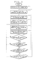
- Figure 1 illustrates the constitution of a display device according to a preferred embodiment of the present invention.
- Figure 2 is an operational flow chart of the preferred embodiment of the present invention.
- Figure 1 shows the display device according to the present invention, which is a vehicle navigation device on which a VICS receiver is mounted, consisting of GPS receiver 1, VICS receiver 2, location computing section 3, VICS information recording section 4, map information recording section 5, map drawing section 6, displaying section 7, VICS information extracting section 8, VICS image composing section 9, VICS image superposing section 10, input operating section 11, controlling section 12 and processor (CPU) 13 for carrying out the processing.
- a vehicle navigation device on which a VICS receiver is mounted, consisting of GPS receiver 1, VICS receiver 2, location computing section 3, VICS information recording section 4, map information recording section 5, map drawing section 6, displaying section 7, VICS information extracting section 8, VICS image composing section 9, VICS image superposing section 10, input operating section 11, controlling section 12 and processor (CPU) 13 for carrying out the processing.
- the GPS receiver 1 receives GPS information from a GPS satellite (not shown in the figure).
- the location computing section 3 computes the present location of the vehicle on the basis of the received GPS information.
- the map drawing section 6 reads out the map information of the desired zone around the present location of the vehicle, which is computed by the location computing section 3, from the map information recording section 5, then composes an image of the map on the basis of the read-out map information and then, displays the image of the map on the displaying section 7 together with a mark indicating the present location of the vehicle.
- VICS information The traffic information (hereinafter, VICS information) received by the VICS receiver 2 is recorded by the VICS information recording section 4.
- the VICS information extracting section 8 extracts the VICS information of the map zone, which is displayed on the displaying section 7 by the map drawing section 6, from the VICS information recording section 4.
- the VICS image composing section 9 composes the VICS image on the basis of the extracted VICS information.
- the VICS image superposing section 10 superposes the composed VICS image on the image of the map, which is drawn by the map drawing section 6, and displays thus superposed images on the displaying section 7.
- VICS information which is received by the VICS receiver 2 at step S1, is recorded in the VICS information recording section 4 at step S2.
- the VICS information extracting section 8 extracts the VICS information of the map zone, which is displayed on the displaying section 7, from the VICS information recording section 4.
- the VICS image composing section 9 composes a congestion/regulation image on the basis of the VICS information extracted at step S3.
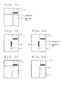
- Figures 3A shows a map 7A, which is displayed on the displaying section 7.
- a reference numeral 7B indicates an expressway while a reference numeral 7C indicates an ordinary way.
- the VICS image composing section 9 composes the traffic information images, corresponding to traffic informations such as congestion/regulation zone of an expressway or an ordinary way, as shown in Figs. 3B, 3C and 3D.
- a traffic information image in which a congestion zone is indicated by an arrow along the expressway 7B, is composed as shown in Fig. 3B, while a traffic information image, in which a congestion zone is indicated by an arrow along the ordinary way 7C, and another traffic information image, in which a regulation zone is indicated by an arrow along the ordinary way 7C, are composed.
- a color inside the arrow of the traffic information image is different depending upon the type of the road traffic information and is displayed with a color scheme shown in Fig. 4A, for example. That is, the color is light blue for no congestion, orange for congestion to some extent, red for congestion, yellow for speed regulation, and pink for chained-tire regulation.
- the type of the roads such as an expressway and ordinary way, can be distinguished by using arrows, a periphery of which is colored with blue for an expressway and with while for an ordinary way as shown in Fig. 4B.
- an expressway and ordinary way can be distinguished from each other by using the different color at the periphery of the arrow. Moreover, even for a zone in which an expressway and ordinary way are overlapped with each other, an expressway and ordinary way can be easily distinguished from each other by turning the display of the arrow on and off.
- the colors for displaying are not limited to those shown in Figs. 4A and 4B.
- the VICS image superposing section 10 superposes one image of the traffic information images composed at step S4 on the image of the map, which is drawn by the map drawing section 6.
- step S6 the displaying section 7 displays the image of the map, on which the traffic information is superposed at step S5.
- step S7 the VICS image superposing section 10 judges whether or not a predetermined time (for example, 0.5 second) is passed, then if judged passed, the system advances to step S8, on the other hand if there is a traffic information image that is not yet superposed, the system turns back to step S5 and next traffic information image composed at step S4 is superposed on the image of the map, and then the flow from step S5 to step 8 is repeated.
- a predetermined time for example, 0.5 second
- Figure 5 shows an image displayed on the displaying section 7.
- the map drawing section 6 draws a map shown in Fig. 3A
- the VICS image composing section 9 composes traffic information images shown in Figs. 3B, 3C and 3D.
- the VICS image superposing section 10 first superposes a traffic information (expressway/congestion) image shown in Fig. 3B on the image of the map shown in Fig. 3A, thereby composing the superposed image shown in Fig. 5A.
- the superposed image is displayed for 0.5 second.
- the VICS image superposing section 10 superposes a traffic information (ordinary way/congestion) image shown in Fig. 3C on the image of the map shown in Fig. 3A, thereby composing the superposed image shown in Fig. 5B.
- the superposed image is displayed for 0.5 second.
- the VICS image superposing section 10 superposes a traffic information (ordinary way/regulation) image shown in Fig. 3D on the image of the map shown in Fig. 3A, thereby composing the superposed image shown in Fig. 5C.
- the superposed image is displayed for 0.5 second.
- the images such as traffic congestion and regulation are successively repeatedly displayed for a predetermined period of time, therefore a driver of the vehicle can easily see the traffic information even if the width of the arrow indicating the above-mentioned zone is constant.
- step S9 the controlling section 12 judges whether or not a zone of the map to be displayed, which is composed by the map drawing section 6, should be changed. If judged YES, the system turns back to step S3, then the steps S3 to S9 are repeated.
- step S10 at which the controlling section 12 judges whether or not the record in the VICS information recording section 4 is renewed. If judged NO, the system turns back to step 5, then the steps S5 to S10 are repeated. On the other hand, if judged YES, the system turns back to step 2, then the steps S2 to S10 are repeated.
- each traffic information of an expressway or ordinary way which is composed by the VICS image composing section 9, is successively displayed with being superposed with the image of the map.
- the traffic information may be separately displayed from each other between an expressway and ordinary way.
- VICS image superposing section 10 successively superposes the traffic information images, which is composed by the VICS image composing section 9, on the image of the map with separating the traffic information images into the image of an expressway and that of an ordinary way.
- the traffic congestion image shown in Fig. 3B is superposed on the image of the map shown in Fig. 3A, thereby a superposed image shown in Fig. 6A is composed and displayed for 0.5 second.
- the traffic regulation image shown in Fig. 3D is superposed, then the fraffic congestion image shown in Fig. 3C is superposed on the image of the map shown in Fig. 3A, thereby a superposed image shown in Fig. 6B is composed and displayed for 0.5 second.
- the traffic regulation image shown in Fig. 3D is superposed on the superposed image shown in Fig. 6B, thereby a superposed image shown in Fig. 6C is composed and displayed for 0.5 second.
- each display as shown in Fig. 6A, 6B or 6C is repeated.
- an expressway may be always displayed, while an ordinary way may be displayed with being turned on and off.
- the VICS image superposing section 10 superposes the traffic congestion image of the expressway shown in Fig. 3B on the image of the map shown in Fig. 3A, thereby a superposed image shown in Fig. 7A is composed and displayed for 0.5 second.
- each display as shown in Fig. 7A, 7B or 7C is repeated.
- an ordinary way may be always displayed, while an expressway may be displayed with being turned on and off.
- an ordinary way may be displayed with being turned on and off after an expressway and ordinary way are simultaneously displayed.
- the VICS image superposing section 10 successively superposes the traffic congestion image of the expressway shown in Fig. 3B, the traffic regulation image of the ordinary ways shown in Fig. 3D, and the traffic congestion image of the ordinary way shown in Fig. 3C on the image of the map shown in Fig. 3A, thereby a superposed image shown in Fig. 8A is composed and displayed for 0.5 second.
- each display as shown in Fig. 8A or 8B is repeated.
- each image corresponding to the respective traffic information of roads on the map is composed, then thus composed images are successively repeatedly superposed and displayed on the image of the map for a predetermined period of time, therefore a driver of the vehicle can easily see the traffic information.
Landscapes
- Engineering & Computer Science (AREA)
- Radar, Positioning & Navigation (AREA)
- Remote Sensing (AREA)
- General Physics & Mathematics (AREA)
- Physics & Mathematics (AREA)
- Environmental Sciences (AREA)
- Life Sciences & Earth Sciences (AREA)
- Environmental & Geological Engineering (AREA)
- Ecology (AREA)
- Automation & Control Theory (AREA)
- Biodiversity & Conservation Biology (AREA)
- Atmospheric Sciences (AREA)
- Navigation (AREA)
- Instructional Devices (AREA)
- Traffic Control Systems (AREA)
Applications Claiming Priority (2)
| Application Number | Priority Date | Filing Date | Title |
|---|---|---|---|
| JP2000235613 | 2000-08-03 | ||
| JP2000235613A JP2002048583A (ja) | 2000-08-03 | 2000-08-03 | 表示装置 |
Publications (3)
| Publication Number | Publication Date |
|---|---|
| EP1187082A2 true EP1187082A2 (de) | 2002-03-13 |
| EP1187082A3 EP1187082A3 (de) | 2003-05-14 |
| EP1187082B1 EP1187082B1 (de) | 2007-12-12 |
Family
ID=18727799
Family Applications (1)
| Application Number | Title | Priority Date | Filing Date |
|---|---|---|---|
| EP01118444A Expired - Lifetime EP1187082B1 (de) | 2000-08-03 | 2001-07-31 | Anzeigevorrichtung für Fahrzeug |
Country Status (4)
| Country | Link |
|---|---|
| US (1) | US6574555B2 (de) |
| EP (1) | EP1187082B1 (de) |
| JP (1) | JP2002048583A (de) |
| DE (1) | DE60131810T2 (de) |
Cited By (3)
| Publication number | Priority date | Publication date | Assignee | Title |
|---|---|---|---|---|
| EP1626250A1 (de) * | 2004-08-13 | 2006-02-15 | Alpine Electronics, Inc. | Fahrzeugnavigationssystem |
| WO2016087906A1 (en) * | 2014-12-05 | 2016-06-09 | Audi Ag | Display device for a vehicle as well as method for assisting a driver of a vehicle, in particular a passenger vehicle |
| EP2990764A4 (de) * | 2013-07-29 | 2016-06-15 | Aisin Aw Co | Verkehrsinformationsbenachrichtigungssystem, verkehrsinformationsbenachrichtigungsvorrichtung, verkehrsinformationsbenachrichtigungsverfahren und computerprogramm |
Families Citing this family (14)
| Publication number | Priority date | Publication date | Assignee | Title |
|---|---|---|---|---|
| KR20040105200A (ko) * | 2003-06-05 | 2004-12-14 | 엘지전자 주식회사 | 차량항법시스템의 교통정보표시방법 |
| US7349799B2 (en) * | 2004-04-23 | 2008-03-25 | Lg Electronics Inc. | Apparatus and method for processing traffic information |
| US7148816B1 (en) * | 2004-08-30 | 2006-12-12 | Rockwell Collins, Inc. | Aircraft traffic source selection and display system and method |
| JP4802531B2 (ja) * | 2005-03-28 | 2011-10-26 | 日産自動車株式会社 | 交通情報表示装置および方法 |
| JP4509153B2 (ja) * | 2007-08-31 | 2010-07-21 | 三洋電機株式会社 | ナビゲーション装置及び方法 |
| US20090171556A1 (en) * | 2007-12-31 | 2009-07-02 | Telenav, Inc. | Mutable Mobile Traffic Routing System |
| CN102110128A (zh) * | 2009-12-28 | 2011-06-29 | 日电(中国)有限公司 | 基于交通信息元素知识库的交通信息转化方法和装置 |
| US9164281B2 (en) | 2013-03-15 | 2015-10-20 | Honda Motor Co., Ltd. | Volumetric heads-up display with dynamic focal plane |
| US9378644B2 (en) | 2013-03-15 | 2016-06-28 | Honda Motor Co., Ltd. | System and method for warning a driver of a potential rear end collision |
| US9747898B2 (en) | 2013-03-15 | 2017-08-29 | Honda Motor Co., Ltd. | Interpretation of ambiguous vehicle instructions |
| US10339711B2 (en) | 2013-03-15 | 2019-07-02 | Honda Motor Co., Ltd. | System and method for providing augmented reality based directions based on verbal and gestural cues |
| US9393870B2 (en) | 2013-03-15 | 2016-07-19 | Honda Motor Co., Ltd. | Volumetric heads-up display with dynamic focal plane |
| US9251715B2 (en) | 2013-03-15 | 2016-02-02 | Honda Motor Co., Ltd. | Driver training system using heads-up display augmented reality graphics elements |
| US10215583B2 (en) | 2013-03-15 | 2019-02-26 | Honda Motor Co., Ltd. | Multi-level navigation monitoring and control |
Citations (7)
| Publication number | Priority date | Publication date | Assignee | Title |
|---|---|---|---|---|
| DE3918668A1 (de) * | 1989-06-08 | 1990-12-13 | Philips Patentverwaltung | Anordnung zur uebermittlung von verkehrstechnischen daten |
| US5313200A (en) * | 1991-03-28 | 1994-05-17 | Nissan Motor Co., Ltd. | Road traffic congestion display system |
| JPH07239997A (ja) * | 1994-02-28 | 1995-09-12 | Zanabui Informatics:Kk | 道路交通情報表示装置 |
| US5694122A (en) * | 1995-11-17 | 1997-12-02 | Matsushita Electric Industrial Co., Ltd. | Jam information display using an arrow whose attribute value changes from a jam tail to a jam head |
| US5739773A (en) * | 1995-11-17 | 1998-04-14 | Matsushita Electric Industrial Co., Ltd. | Vehicular navigation apparatus enabling easy recognition of displayed traffic information |
| US5864305A (en) * | 1994-03-04 | 1999-01-26 | Ab Volvo | Traffic information system |
| JP2000099891A (ja) * | 1998-09-28 | 2000-04-07 | Hitachi Eng Co Ltd | 交通情報表示装置及び表示方法 |
Family Cites Families (5)
| Publication number | Priority date | Publication date | Assignee | Title |
|---|---|---|---|---|
| US5293163A (en) * | 1990-06-06 | 1994-03-08 | Mazda Motor Corporation | Navigation apparatus for vehicles |
| JP3371605B2 (ja) * | 1995-04-19 | 2003-01-27 | 日産自動車株式会社 | 大気効果表示機能付き鳥瞰図表示ナビゲーションシステム |
| JP3483672B2 (ja) * | 1995-09-06 | 2004-01-06 | 三菱電機株式会社 | ナビゲーション装置 |
| JP3174265B2 (ja) * | 1996-04-19 | 2001-06-11 | 三菱電機株式会社 | 交通情報表示装置 |
| JP3698835B2 (ja) * | 1996-10-25 | 2005-09-21 | 三菱電機株式会社 | 交通情報表示装置及びその表示方法並びに交通情報表示装置用表示制御プログラムを記録した媒体 |
-
2000
- 2000-08-03 JP JP2000235613A patent/JP2002048583A/ja active Pending
-
2001
- 2001-07-19 US US09/907,936 patent/US6574555B2/en not_active Expired - Lifetime
- 2001-07-31 EP EP01118444A patent/EP1187082B1/de not_active Expired - Lifetime
- 2001-07-31 DE DE60131810T patent/DE60131810T2/de not_active Expired - Lifetime
Patent Citations (7)
| Publication number | Priority date | Publication date | Assignee | Title |
|---|---|---|---|---|
| DE3918668A1 (de) * | 1989-06-08 | 1990-12-13 | Philips Patentverwaltung | Anordnung zur uebermittlung von verkehrstechnischen daten |
| US5313200A (en) * | 1991-03-28 | 1994-05-17 | Nissan Motor Co., Ltd. | Road traffic congestion display system |
| JPH07239997A (ja) * | 1994-02-28 | 1995-09-12 | Zanabui Informatics:Kk | 道路交通情報表示装置 |
| US5864305A (en) * | 1994-03-04 | 1999-01-26 | Ab Volvo | Traffic information system |
| US5694122A (en) * | 1995-11-17 | 1997-12-02 | Matsushita Electric Industrial Co., Ltd. | Jam information display using an arrow whose attribute value changes from a jam tail to a jam head |
| US5739773A (en) * | 1995-11-17 | 1998-04-14 | Matsushita Electric Industrial Co., Ltd. | Vehicular navigation apparatus enabling easy recognition of displayed traffic information |
| JP2000099891A (ja) * | 1998-09-28 | 2000-04-07 | Hitachi Eng Co Ltd | 交通情報表示装置及び表示方法 |
Non-Patent Citations (2)
| Title |
|---|
| PATENT ABSTRACTS OF JAPAN vol. 1996, no. 01, 31 January 1996 (1996-01-31) & JP 07 239997 A (ZANABUI INFORMATICS:KK), 12 September 1995 (1995-09-12) * |
| PATENT ABSTRACTS OF JAPAN vol. 2000, no. 07, 29 September 2000 (2000-09-29) & JP 2000 099891 A (HITACHI ENG CO LTD), 7 April 2000 (2000-04-07) * |
Cited By (3)
| Publication number | Priority date | Publication date | Assignee | Title |
|---|---|---|---|---|
| EP1626250A1 (de) * | 2004-08-13 | 2006-02-15 | Alpine Electronics, Inc. | Fahrzeugnavigationssystem |
| EP2990764A4 (de) * | 2013-07-29 | 2016-06-15 | Aisin Aw Co | Verkehrsinformationsbenachrichtigungssystem, verkehrsinformationsbenachrichtigungsvorrichtung, verkehrsinformationsbenachrichtigungsverfahren und computerprogramm |
| WO2016087906A1 (en) * | 2014-12-05 | 2016-06-09 | Audi Ag | Display device for a vehicle as well as method for assisting a driver of a vehicle, in particular a passenger vehicle |
Also Published As
| Publication number | Publication date |
|---|---|
| DE60131810T2 (de) | 2008-04-03 |
| DE60131810D1 (de) | 2008-01-24 |
| EP1187082B1 (de) | 2007-12-12 |
| JP2002048583A (ja) | 2002-02-15 |
| US20020032519A1 (en) | 2002-03-14 |
| US6574555B2 (en) | 2003-06-03 |
| EP1187082A3 (de) | 2003-05-14 |
Similar Documents
| Publication | Publication Date | Title |
|---|---|---|
| US6574555B2 (en) | Display device which displays traffic information images on a map | |
| US5537323A (en) | Navigation device vehicle comprising the device | |
| US5323321A (en) | Land vehicle navigation apparatus | |
| US6012014A (en) | Map display apparatus for motor vehicle | |
| EP0767448B1 (de) | Fahrzeugsnavigationsgerät | |
| EP0953825B1 (de) | Routensuchvorrichtung | |
| EP1543294B1 (de) | Fahrzeugnavigationssystem mit geländenavigation | |
| US6732049B2 (en) | Vehicle navigation system and method | |
| US7170518B1 (en) | Selective rendering of cartographic entities for a navigation system | |
| US5739773A (en) | Vehicular navigation apparatus enabling easy recognition of displayed traffic information | |
| EP2172742A1 (de) | Navigationsgerät | |
| JP4845876B2 (ja) | 道路景観地図作成装置、方法及びプログラム | |
| KR19980032059A (ko) | 교통 정보 표시 장치와 그 표시 방법 및 교통 정보 표시 장치용 표시 제어 프로그램을 기록한 매체 | |
| US5694122A (en) | Jam information display using an arrow whose attribute value changes from a jam tail to a jam head | |
| JPH10300487A (ja) | 交通情報表示装置 | |
| JP2005233973A (ja) | 単一統合型印刷データ入力カードを使用するナビゲーション装置 | |
| US20100004859A1 (en) | Method for display route information for a navigation system | |
| JP2005308475A (ja) | 車載情報端末 | |
| JP2001133274A (ja) | 道路交通情報の簡易図形表示のためのデータ処理方法 | |
| JPH06223296A (ja) | ナビゲーション表示における案内情報の選択方法 | |
| JPH10283589A (ja) | ナビゲーション装置における道路混雑状況表示方法 | |
| EP0434122A1 (de) | Methode zur Anzeige von Fahrinformationen für den Fahrer eines Fahrzeuges auf einer Anzeige in diesem Fahrzeug | |
| JP2006153882A (ja) | 表示装置 | |
| JP2001159534A (ja) | ナビゲーション装置 | |
| JPH04166979A (ja) | 車載用ナビゲーション装置 |
Legal Events
| Date | Code | Title | Description |
|---|---|---|---|
| PUAI | Public reference made under article 153(3) epc to a published international application that has entered the european phase |
Free format text: ORIGINAL CODE: 0009012 |
|
| AK | Designated contracting states |
Kind code of ref document: A2 Designated state(s): AT BE CH CY DE DK ES FI FR GB GR IE IT LI LU MC NL PT SE TR |
|
| AX | Request for extension of the european patent |
Free format text: AL;LT;LV;MK;RO;SI |
|
| RIC1 | Information provided on ipc code assigned before grant |
Free format text: 7G 01C 21/36 A, 7G 08G 1/0969 B |
|
| PUAL | Search report despatched |
Free format text: ORIGINAL CODE: 0009013 |
|
| AK | Designated contracting states |
Designated state(s): AT BE CH CY DE DK ES FI FR GB GR IE IT LI LU MC NL PT SE TR |
|
| AX | Request for extension of the european patent |
Extension state: AL LT LV MK RO SI |
|
| 17P | Request for examination filed |
Effective date: 20030707 |
|
| AKX | Designation fees paid |
Designated state(s): DE FR GB |
|
| 17Q | First examination report despatched |
Effective date: 20060621 |
|
| GRAP | Despatch of communication of intention to grant a patent |
Free format text: ORIGINAL CODE: EPIDOSNIGR1 |
|
| GRAS | Grant fee paid |
Free format text: ORIGINAL CODE: EPIDOSNIGR3 |
|
| GRAA | (expected) grant |
Free format text: ORIGINAL CODE: 0009210 |
|
| AK | Designated contracting states |
Kind code of ref document: B1 Designated state(s): DE FR GB |
|
| REG | Reference to a national code |
Ref country code: GB Ref legal event code: FG4D |
|
| REF | Corresponds to: |
Ref document number: 60131810 Country of ref document: DE Date of ref document: 20080124 Kind code of ref document: P |
|
| REG | Reference to a national code |
Ref country code: GB Ref legal event code: 746 Effective date: 20080603 |
|
| ET | Fr: translation filed | ||
| PLBE | No opposition filed within time limit |
Free format text: ORIGINAL CODE: 0009261 |
|
| STAA | Information on the status of an ep patent application or granted ep patent |
Free format text: STATUS: NO OPPOSITION FILED WITHIN TIME LIMIT |
|
| 26N | No opposition filed |
Effective date: 20080915 |
|
| REG | Reference to a national code |
Ref country code: FR Ref legal event code: PLFP Year of fee payment: 16 |
|
| REG | Reference to a national code |
Ref country code: FR Ref legal event code: PLFP Year of fee payment: 17 |
|
| REG | Reference to a national code |
Ref country code: FR Ref legal event code: PLFP Year of fee payment: 18 |
|
| PGFP | Annual fee paid to national office [announced via postgrant information from national office to epo] |
Ref country code: FR Payment date: 20200611 Year of fee payment: 20 |
|
| PGFP | Annual fee paid to national office [announced via postgrant information from national office to epo] |
Ref country code: DE Payment date: 20200722 Year of fee payment: 20 Ref country code: GB Payment date: 20200722 Year of fee payment: 20 |
|
| REG | Reference to a national code |
Ref country code: DE Ref legal event code: R071 Ref document number: 60131810 Country of ref document: DE |
|
| REG | Reference to a national code |
Ref country code: GB Ref legal event code: PE20 Expiry date: 20210730 |
|
| PG25 | Lapsed in a contracting state [announced via postgrant information from national office to epo] |
Ref country code: GB Free format text: LAPSE BECAUSE OF EXPIRATION OF PROTECTION Effective date: 20210730 |