EP3897002B1 - Anwendungsdienstserver, regionsbasiertes informationsverarbeitungsverfahren und benutzergerät - Google Patents
Anwendungsdienstserver, regionsbasiertes informationsverarbeitungsverfahren und benutzergerät Download PDFInfo
- Publication number
- EP3897002B1 EP3897002B1 EP20179154.8A EP20179154A EP3897002B1 EP 3897002 B1 EP3897002 B1 EP 3897002B1 EP 20179154 A EP20179154 A EP 20179154A EP 3897002 B1 EP3897002 B1 EP 3897002B1
- Authority
- EP
- European Patent Office
- Prior art keywords
- location information
- information
- identification information
- reference object
- location
- Prior art date
- Legal status (The legal status is an assumption and is not a legal conclusion. Google has not performed a legal analysis and makes no representation as to the accuracy of the status listed.)
- Active
Links
Images


Classifications
-
- H—ELECTRICITY
- H04—ELECTRIC COMMUNICATION TECHNIQUE
- H04W—WIRELESS COMMUNICATION NETWORKS
- H04W4/00—Services specially adapted for wireless communication networks; Facilities therefor
- H04W4/02—Services making use of location information
- H04W4/029—Location-based management or tracking services
-
- H—ELECTRICITY
- H04—ELECTRIC COMMUNICATION TECHNIQUE
- H04W—WIRELESS COMMUNICATION NETWORKS
- H04W4/00—Services specially adapted for wireless communication networks; Facilities therefor
- H04W4/02—Services making use of location information
- H04W4/021—Services related to particular areas, e.g. point of interest [POI] services, venue services or geofences
-
- G—PHYSICS
- G06—COMPUTING OR CALCULATING; COUNTING
- G06F—ELECTRIC DIGITAL DATA PROCESSING
- G06F16/00—Information retrieval; Database structures therefor; File system structures therefor
- G06F16/20—Information retrieval; Database structures therefor; File system structures therefor of structured data, e.g. relational data
- G06F16/29—Geographical information databases
-
- G—PHYSICS
- G08—SIGNALLING
- G08G—TRAFFIC CONTROL SYSTEMS
- G08G1/00—Traffic control systems for road vehicles
- G08G1/09—Arrangements for giving variable traffic instructions
- G08G1/0962—Arrangements for giving variable traffic instructions having an indicator mounted inside the vehicle, e.g. giving voice messages
- G08G1/0967—Systems involving transmission of highway information, e.g. weather, speed limits
- G08G1/096766—Systems involving transmission of highway information, e.g. weather, speed limits where the system is characterised by the origin of the information transmission
- G08G1/096775—Systems involving transmission of highway information, e.g. weather, speed limits where the system is characterised by the origin of the information transmission where the origin of the information is a central station
-
- H—ELECTRICITY
- H04—ELECTRIC COMMUNICATION TECHNIQUE
- H04L—TRANSMISSION OF DIGITAL INFORMATION, e.g. TELEGRAPHIC COMMUNICATION
- H04L51/00—User-to-user messaging in packet-switching networks, transmitted according to store-and-forward or real-time protocols, e.g. e-mail
- H04L51/21—Monitoring or handling of messages
- H04L51/224—Monitoring or handling of messages providing notification on incoming messages, e.g. pushed notifications of received messages
-
- H—ELECTRICITY
- H04—ELECTRIC COMMUNICATION TECHNIQUE
- H04L—TRANSMISSION OF DIGITAL INFORMATION, e.g. TELEGRAPHIC COMMUNICATION
- H04L67/00—Network arrangements or protocols for supporting network services or applications
- H04L67/2866—Architectures; Arrangements
- H04L67/30—Profiles
- H04L67/306—User profiles
-
- H—ELECTRICITY
- H04—ELECTRIC COMMUNICATION TECHNIQUE
- H04L—TRANSMISSION OF DIGITAL INFORMATION, e.g. TELEGRAPHIC COMMUNICATION
- H04L67/00—Network arrangements or protocols for supporting network services or applications
- H04L67/50—Network services
- H04L67/52—Network services specially adapted for the location of the user terminal
-
- H—ELECTRICITY
- H04—ELECTRIC COMMUNICATION TECHNIQUE
- H04L—TRANSMISSION OF DIGITAL INFORMATION, e.g. TELEGRAPHIC COMMUNICATION
- H04L67/00—Network arrangements or protocols for supporting network services or applications
- H04L67/50—Network services
- H04L67/55—Push-based network services
-
- H—ELECTRICITY
- H04—ELECTRIC COMMUNICATION TECHNIQUE
- H04W—WIRELESS COMMUNICATION NETWORKS
- H04W4/00—Services specially adapted for wireless communication networks; Facilities therefor
- H04W4/02—Services making use of location information
- H04W4/023—Services making use of location information using mutual or relative location information between multiple location based services [LBS] targets or of distance thresholds
-
- H—ELECTRICITY
- H04—ELECTRIC COMMUNICATION TECHNIQUE
- H04W—WIRELESS COMMUNICATION NETWORKS
- H04W4/00—Services specially adapted for wireless communication networks; Facilities therefor
- H04W4/06—Selective distribution of broadcast services, e.g. multimedia broadcast multicast service [MBMS]; Services to user groups; One-way selective calling services
- H04W4/08—User group management
-
- H—ELECTRICITY
- H04—ELECTRIC COMMUNICATION TECHNIQUE
- H04W—WIRELESS COMMUNICATION NETWORKS
- H04W4/00—Services specially adapted for wireless communication networks; Facilities therefor
- H04W4/30—Services specially adapted for particular environments, situations or purposes
- H04W4/40—Services specially adapted for particular environments, situations or purposes for vehicles, e.g. vehicle-to-pedestrians [V2P]
Definitions
- the disclosure relates to an application service server, a region-based information processing method, and user equipment.
- C-V2X vehicle-to-everything
- eMBMS evolved Multimedia Broadcast Multicast Service
- information is generally transmitted back to an application server through a vehicle, a road side unit (RSU) and various mobile devices.
- RSU road side unit
- the information is unicast or broadcast by the base station to a mobile terminal device of a road user in a service range.
- V2X-based services release information by broadcasting.
- a V2X mobile terminal device such as an on-board unit (OBU), or a pedestrian handheld device
- OBU on-board unit
- a pedestrian handheld device of the road user generally cannot determine a subsequent application until confirming relative locations between surrounding objects, events, and the road user himself based on a coordinate location of the Global Positioning System (GPS).
- GPS Global Positioning System
- a service range of a base station of a cellular application may vary from one kilometer to tens of kilometers, and the V2X mobile terminal device needs to process all information within the service range.
- excessive information is obtained by the terminal device through a network.
- a geographic location is calculated for each message, many unnecessary computing operations are performed, consuming a considerable quantity of computing resources.
- the mobile terminal device when the mobile terminal device is an in-vehicle device, the processing of a large amount of information as in the related art will occupy a lot of computing resources, affecting the response time of the application or even leading to a result that the application cannot respond in time.
- the mobile terminal device When the mobile terminal device is a device of a vulnerable road user (VRU), the battery state design needs to be considered in addition to the computing support, and different from an in-vehicle device, the mobile terminal device normally is not able to repeatedly compute useless information for a long time. For example, while a vehicle is moving forward, in a conventional operation mode, real-time statuses of all vehicles behind the vehicle, road event information (such as road construction) and other information need to be processed and computed. However, all such rear-related information may be irrelevant to a subsequent travel route of the vehicle.
- road event information such as road construction
- US 2018/306600 A1 discloses a method of providing data associated with a point of interest (POI), comprising determining, based on a location of a POI, a portion of digital map data of a geographic region, said digital map data comprising a plurality of segments representing navigable elements of a navigable network within the geographic region, and generating POI-map data associated with the POI indicative of at least some segments within the portion of digital map data.
- POI point of interest
- CN 110 942 652 A discloses a method and a device for outputting road identification information.
- the method comprises the following steps: acquiring position information of a vehicle; determining road identification information to be output currently according to the position information of the vehicle; and outputting the determined road identification information in a predetermined manner.
- the present invention is provided by the appended claims.
- the following disclosure serves a better understanding of the present invention.
- the present disclosure provides an application service server, a region-based information processing method, and user equipment.
- FIG. 1 is a block diagram of components of a communications system 100 according to an embodiment of the present disclosure.
- the communications system 100 includes (but is not limited to) one or more message generators 10, an application service server 30, one or more relay stations 50, and one or more pieces of user equipment 70.
- the message generator 10 may be a mobile device (such as a smart phone, a tablet computer, or a smart watch), an on-board unit (OBU), a road side unit (RSU), or one of various sensors (such as sensors of a sign, an image, temperature, humidity, brightness, or the like).
- a mobile device such as a smart phone, a tablet computer, or a smart watch
- OBU on-board unit
- RSU road side unit
- sensors such as sensors of a sign, an image, temperature, humidity, brightness, or the like.
- the application service server 30 may be a desktop computer, one of various servers, a workstation, a background host, or another apparatus.
- the application service server 30 includes (but is not limited to) a communications transceiver 31, a memory 33, and a processor 35.
- the communications transceiver 31 is a transceiver supporting a wired network such as the Ethernet, an optical network or a cable (possibly including, but without limitation, components such as a connection interface, a signal converter, and a communications protocol processing chip), or a transceiver supporting a wireless network such as a WiFi, third-generation (3G), fourth-generation (4G) or later-generation mobile network (possibly including, but without limitation, components such as an antenna, a digital-to-analog/analog-to-digital converter, and a communications protocol processing chip).
- a wired network such as the Ethernet
- an optical network or a cable possibly including, but without limitation, components such as a connection interface, a signal converter, and a communications protocol processing chip
- a transceiver supporting a wireless network such as a WiFi, third-generation (3G), fourth-generation (4G) or later-generation mobile network (possibly including, but without limitation, components such as an antenna, a digital-to-analog/an
- the memory 33 may be any form of fixed or removable random access memory (RAM), read-only memory (ROM), flash memory or a similar component, or a combination thereof.
- RAM random access memory
- ROM read-only memory
- flash memory or a similar component, or a combination thereof.
- the processor 35 is configured to process digital signals and execute a program according to an exemplary embodiment of the present disclosure.
- Functions of the processor 35 may be implemented by a programmable unit such as a central processing unit (CPU), a microprocessor, a microcontroller, a digital signal processing (DSP) chip, and a field programmable logic gate array (FPGA).
- the functions of the processor 35 may also be implemented by an independent electronic apparatus or an integrated circuit (IC), and operations of the processor 35 may also be implemented by software.
- the relay station 50 may be a home evolved NodeB (HeNB), an eNB, a next-generation NodeB (gNB), a base transceiver system (BTS), an RSU, or a repeater.
- HeNB home evolved NodeB
- eNB eNB
- gNB next-generation NodeB
- BTS base transceiver system
- RSU RSU
- the user equipment 70 may be an apparatus such as a smart phone, a tablet computer, a smart watch, a notebook computer, or an OBU.
- the user equipment 70 includes (but is not limited to) a communications transceiver 71, a memory 73, a processor 75, and a positioning controller 77.
- the communications transceiver 71 For implementations of the communications transceiver 71, the memory 73, and the processor 75, reference may be made to the descriptions of the communications transceiver 31, the memory 33, and the processor 35, and the details are omitted here.
- the positioning controller 77 may be a positioning device that supports any type of global navigation satellite system (GNSS), or a receiver or transceiver based on various wireless communications technologies such as a mobile network technology, a WiFi technology, a Bluetooth technology, an infrared technology, an RFID technology, a ZigBee technology, an ultra-wide band (UWB) technology, or an ultrasonic wave technology (that is, the positioning controller 77 may also be a communications transceiver 71), and may transmit or receive a wireless signal actively or passively accordingly. The wireless signal may be used to determine a location of the user equipment 70 to which the positioning controller 77 belongs.
- GNSS global navigation satellite system
- the application service server 30 and the user equipment 70 transmit or receive data through the relay station 50.
- data is transmitted through a Uu interface or a PCS interface in a V2X technology.
- the application service server 30 may directly communicate with the user equipment 70.
- FIG. 2 is a flowchart of a region-based information processing method according to an embodiment of the present disclosure.
- the processor 35 of the application service server 30 receives an initial message from the message generator 10 through the communications transceiver 31 (step S210).
- the initial message may include notification content corresponding to location information of the message generator 10.
- the location information is a longitude coordinate, a latitude coordinate, and/or an altitude coordinate, or a two-degree transverse Mercator coordinate, and is used to represent a location of the message generator 10 or a region in which the message generator 10 is located.
- the notification content may be associated with traffic signs, road signs, road condition information, road events, vehicle real-time status, pedestrian status, weather information, sensing information, or various danger or warning information, and is not limited in the embodiments of the present disclosure.
- the initial message is a notification message released by the message generator 10 to other apparatuses to indicate its location or region.
- the processor 35 may determine identification information according to location information (step S230). Specifically, the identification information is provided by a geographic information service (for example, Open Street Map (OSM), an electronic map, or various geographic information systems (GIS)).
- the geographic information service is a service that integrates geographic information (for example, roads, administrative regions, weather sensing results, and industrial forms) with map information (for example, region or location).
- the processor 35 may use the identification information to distinguish several reference objects in different locations or regions (for example, administrative regions, roads, buildings, rivers, sidewalks, water pipes, communications networks, or electric wires).
- the identification information is a road number, a wire pole number, or a distribution box number.
- the identification information is a cartographic data attribute defined by a geographic information service.
- the cartographic data attribute may vary with different cartographic data types (for example, roads, buildings, rivers, sidewalks, water pipes, communications networks, or electrical wires).
- the cartographic data attribute may include an identifier and corresponding representative location information.
- the identifier may be a word, or a numeral, or a symbol, or a combination thereof, and may also be known as a serial number, a sequence number, or a code. For example, an identifier of China Road First Section is 123, and an identifier of China Road Second Section is 124.
- the representative location information is associated with a geographic coordinate system.
- the representative location information is a serial number, sequence number, or code used to represent the location information (that is, converted into another geocoding format), but may also be the same or similar coordinates.
- Each reference object has a corresponding identifier and corresponding representative location information. That is, the identifier may be used to find a specific reference object, and the representative location information may be used to find a location of the reference object or a region in which the reference object is located.
- FIG. 3 is an example illustrating road-related identification information.
- the identification information 311 of the road 310 is an identifier of 323764068.
- the road 310 is formed by two nodes 312, and the road of the same name may form a node 312 due to changes in road length, turning, and bending.
- Different identifiers are assigned by the geographic information service to roads located in different up, down, left, and right directions at an intersection in the figure.
- the identification information 311 may be used to distinguish roads in different sections and different directions.
- the cartographic data attribute may exist in different forms and/or have different items depending on the cartographic data type or the geographic information service.
- the cartographic data attribute may further include road forms (for example, one-way or two-way road), the number of lanes (for confirming road width), and the like.
- the identification information may also include one of the identifier or the representative location information.
- the identification information may also be data attributes representing different locations or regions, for example, sensing statistics results of a specific region.
- the processor 35 may load map information provided by the geographic information service. For example, the processor 35 obtains map information by downloading, reading, or the like. This map information is associated with cartographic data attributes or other data attributes of the reference objects. Each cartographic data attribute or data attribute may include second location information.
- the second location information is coordinates defined by the geographic coordinate system (for example, latitude and longitude coordinates, or two-degree transverse Mercator coordinates). That is, each cartographic data attribute or data attribute is cartographic data or other data of the location or region corresponding to the second location information.
- the processor 35 may convert the second location information of the reference objects into corresponding representative location information separately. Each piece of representative location information is in an index form.
- Different representative location information in the index form may be a sequence number or serial number arranged according to a specific rule or correspondence, so as to facilitate retrieval of corresponding coordinates based on this index.
- the index or identifier form may improve retrieval efficiency.
- the geographic information service may directly provide the representative location information of each reference object in the index form, without requiring the processor 35 to perform conversion between coordinates and the index.
- Each reference object has corresponding identification information that may be used as a basis for distinguishing between different reference objects and identifying the location of each reference object or the region in which the reference object is located. Therefore, after the location information is sorted into a specific reference object, the identification information may be used to understand the location or region corresponding to the initial message.
- FIG. 4 is a flowchart of a method for determining identification information according to an embodiment of the present disclosure.
- the processor 35 may determine one or more reference objects that match the location information (step S410). Locations of the matching reference objects are closer to the location corresponding to the location information than other reference objects.
- FIG. 5 is a flowchart of a method for determining a matching reference object according to an embodiment of the present disclosure.
- each reference object is formed by one or more nodes, that is, each node is located at the location of a corresponding reference object or the region in which the reference object is located.
- the locations of the nodes may be provided by the geographic information service, or may be established by the processor 35 based on a specific rule or correspondence after obtaining map information.
- the processor 35 may calculate a distance from each node to the location corresponding to the location information (step S510), that is, calculate the distance between the location corresponding to the location information and the location of each node.
- the processor 35 may form a node group by using at least two nodes closest to the location corresponding to the location information in each reference object (step S530).
- at least two nodes are included in a range of each reference object.
- Each node group includes at least two nodes among all nodes in the corresponding range. That is, each node group may represent at least a part of the range that covers the reference object.
- the processor 35 may select two or more closest nodes for each reference object based on the distance that corresponds to the node in each reference object and that is obtained in step 5510.
- FIG. 6 is an example illustrating how to determine a matching reference object.
- a cartographic data type of a reference object is a road
- an initial message corresponds to a position L (with a possible positioning error range (ER)).
- Nodes 612-1, 612-2, and 612-3 are included in ranges of roads 610-1, 610-2, and 610-3, respectively.
- two nodes 612-1 closest to the location L will form a node group 620-1; two nodes 612-2 closest to the location L will form a node group 620-2; and two nodes 612-3 closest to the location L will form a node group 620-3.
- the processor 35 uses reference objects within a screening range corresponding to the location information as the matching reference objects.
- the processor 35 may screen node groups by setting a screening range (step S550). That is, the node groups are used to compare whether they are within the screening range.
- the screening range is, for example, a range defined by a circle with a specific radius (such as 50, 100, or 500 meters) and with a circle center located at the location corresponding to the location information, or a range defined by a specific geometric shape centered at the location corresponding to the location information.
- the processor 35 obtains the node groups that are less than 100 meters away from the location corresponding to the location information and that are among the foregoing node groups, and accordingly determines the matching reference objects.
- the processor 35 determines the identification information according to a distance relationship between the location information and the matching reference object (step S430).
- the distance relationship includes a vertical distance between the reference object and the location corresponding to the location information.
- the processor 35 may determine the vertical distance between each matching reference object and the location corresponding to the location information respectively.
- FIG. 7 is a flowchart of a method for determining a distance relationship in relation to a reference object according to an embodiment of the present disclosure. Referring to FIG. 7 , it is assumed that the representative location information of each reference object is determined by at least two nodes within a range of the reference object.
- the processor 35 may form a reference straight line according to at least two nodes in the matching reference objects respectively (step S710). That is, a connection line between at least two nodes in each reference object serves as a reference straight line.
- FIG. 8 is an example illustrating how to determine a vertical distance.
- double-arrowed lines in the figure represent the reference straight lines 613-1, 613-2, and 613-3 of the roads 610-1, 610-2, and 610-3 respectively.
- the reference straight line 613-1 is formed by connecting two nodes 612-1 in the node group 620-1
- the reference straight line 613-2 is formed by connecting two nodes 612-2 in the node group 620-2
- the reference straight line 613-3 is formed by connecting two nodes 612-3 in the node group 620-3.
- the processor 35 may respectively determine the vertical distance from the location corresponding to the location information to each reference straight line (step S730). Specifically, a vertical distance represents a shortest distance from a point to a line or plane. Therefore, the vertical distance determines how close the location corresponding to the location information is to the reference object. For example, referring to FIG. 8 , dashed lines in the figure represent the vertical distances D1, D2, D3 from the location L corresponding to the location information to the roads 610-1, 610-2, 610-3, respectively. The processor 35 may calculate the vertical distance from each location L to each straight line equation by using straight line equations formed by the reference straight lines 613-1, 613-2, and 613-3.
- the processor 35 may select, among the matching reference objects, at least one reference object corresponding to the shortest vertical distance.
- the identification information corresponding to the location information is the identification information associated with the selected reference object.
- the processor 35 may select the identification information of the reference object corresponding to the shortest vertical distance, the second shortest vertical distance, or an otherwise ranked vertical distance as the identification information of the location information.
- FIG. 9 is an example illustrating how to determine identification information.
- the vertical distance D2 is the shortest, and the processor 35 selects the identification information of the road 610-2 corresponding to the vertical distance D2 as the identification information corresponding to the location information.
- a node of each reference object is a part of the reference object to which the node belongs.
- the processor 35 may further determine whether the location corresponding to the location information is located within a covering range of the selected reference object (that is, at least one reference object corresponding to the shortest vertical distance), so as to confirm that the location corresponding to the location information belongs to a specific reference object.
- the covering range may represent a road width, a river width, a range of a construction site, a range of an administrative region, or the like.
- the distance relationship further includes a relationship between the vertical distance and the covering range.
- the processor 35 may compare the vertical distance corresponding to the selected reference object with the covering range of the reference object, that is, check whether the location corresponding to the location information is within the covering range of the reference object. In a case that the location information is accompanied by a positioning error range, the vertical distance may be corrected before being compared with the covering range.
- shortest distances from the nodes 612-2 of the road 610-2 to a curb of the road are approximately equal (that is, half of the road width).
- the road width may be used as a covering range of the road 610-2, and the processor 35 may compare the shortest distance D2 with the road width of the road 610-2. In a case that the shortest distance D2 is less than the road width of the road 610-2, it indicates that the location corresponding to the location information is within the road 610-2. In a case that the shortest distance D2 is not less than the road width of the road 610-2, it indicates that the location corresponding to the location information is not within the road 610-2.
- the processor 35 may determine the identification information of the location information according to a comparison result.
- the comparison result is that the vertical distance is within the covering range. That is, in a case that the comparison result is that the vertical distance is within the covering range, the processor 35 may use the identification information of the reference object corresponding to the vertical distance as the identification information of the location information. In a case that the comparison result is that the vertical distance is not within the covering range, the processor 35 does not use the identification information of the reference object corresponding to the vertical distance as the identification information of the location information. For example, the processor 35 uses a specific identifier different from that of the reference object as the identification information of the location information, or skips generating identification information of the location information.
- the processor 35 may use the identification information of all the reference objects as the identification information of location information, or selects the identification information of a reference object corresponding to the shortest vertical distance as the identification information of the location information. In addition, in other embodiments, the processor 35 may also directly calculate the vertical distances from the location corresponding to the location information to all reference objects without performing the preliminary screening shown in FIG. 5 . Alternatively, the processor 35 may directly select at least one reference object, with a distance from a node of the reference object to the location corresponding to the location information being within the covering range.
- FIG. 10 is a flowchart of a method for generating identification information according to an embodiment of the present disclosure.
- the processor 35 may determine, according to the location relationship, whether the location information belongs to a cartographic data type to which the reference object belongs (step S1010), for example, whether the vertical distance from the location corresponding to the location information to the reference location is within the covering range (for example, in a case that the vertical distance is within the covering range, the location information belongs to the cartographic data type to which the reference object belongs; or, in a case that the vertical distance is not within the covering range, the location information does not belong to the cartographic data type to which the reference object belongs); or, whether the vertical distance is less than another specific value (for example, in a case that the vertical distance is less than a specific value, the location information belongs to the cartographic data type to which the reference object belongs; or, in a case that the vertical distance is not less than a specific value, the location information does not belong to the cartographic data type to which the reference object
- the processor 35 may screen out, according to the distance relationship, the reference objects belonging to a specific cartographic data type.
- the processor 35 may generate, in response to the location information belonging to the cartographic data type, identification information corresponding to the cartographic data type (step S1030).
- the cartographic data type is a road.
- the processor 35 may generate the identification information corresponding to the road 610-2, and use the identification information as the identification information of the location L.
- the processor 35 may skip, in response to the location information not belonging to the cartographic data type, generating identification information corresponding to the cartographic data type (step S1050).
- the processor 35 uses a specific identifier (different from an identifier of any reference object of this cartographic data type) as an identifier of the location information, or directly skips generating no identification information.
- preliminary messages of the selected cartographic data type may be screened out according to the embodiment shown in FIG. 10 , thereby excluding unnecessary preliminary messages.
- the processor 35 can determine whether the location corresponding to the location information is on the road, and accordingly exclude preliminary messages that are not on the road (for example, those inside a building).
- the identification information may further include an indicator that is used to identify the cartographic data type. For example, an indicator of a road is A, and an indicator of a building is B.
- the processor 35 may generate a preprocessed message (step S250). Specifically, the preprocessed message includes the identification information determined above and the notification content in the initial message.
- the application service server 30 may serve as an edge computing platform, and convert the location information into a form of identification information by classifying the location information of the initial message as a specific reference object.
- the processor 35 transmits the preprocessed message through the communications transceiver 31.
- another apparatus such as user equipment 70
- the identifier of 323764068 in the identification information 311 may be used to compare whether the identifier is the same as an identifier to be evaluated.
- the preprocessed message may further include the location information of the initial message or may include no other content than the notification content (that is, without belonging to any reference object).
- FIG. 11 is a flowchart of a region-based information processing method according to an embodiment of the present disclosure.
- the processor 75 receives a preprocessed message from the application service server 30 through the communications transceiver 71 (step S1110).
- the application service server 30 may forward the preprocessed message to one or more relay stations 50 and/or one or more pieces of user equipment 70 through unicast or broadcast.
- the relay station 50 may further forward the preprocessed message to one or more pieces of user equipment 70 within a signal covering range thereof.
- the preprocessed message includes the identification information and notification content, and the identification information is provided by a geographic information service and used to represent location information defined by a geographic coordinate system.
- the processor 75 may process the notification content according to a result of comparison between the identification information and the second identification information (step S1130).
- the second identification information is provided by the geographic information service and used to represent a region of interest to the user equipment 70.
- the format of the second identification information is the same as or similar to that of the identification information.
- this embodiment of the present disclosure can improve computing efficiency by comparing the identification information.
- the processor 75 may compare whether the identifier of the identification information is the same as the identifier of the second identification information, and generate a comparison result accordingly.
- FIG. 12 is a flowchart of a method for determining identification information according to an embodiment of the present disclosure.
- the processor 75 may obtain the location information of the user equipment 70 (that is, coordinates defined by a geographic coordinate system) through the positioning controller 77.
- the processor 75 may determine third identification information according to the location information of the user equipment 70 (step S1210). As regards how to determine the third identification information, reference may be made to the details of determining the identification information according to the location information in step S230 according to the embodiments shown in FIG. 2 to FIG.
- the third identification information replaces the identification information
- the location information of the user equipment 70 replaces the location information of the initial message.
- the third identification information is also location information provided by the geographic information service and used to represent the user equipment 70. In this way, the user equipment 70 may classify its own location information as a specific reference object.
- the third identification information may be updated.
- the processor 75 may compare surrounding reference objects based on a movement status (such as direction or speed) of the user equipment 70 without re-comparing the identification information of all the reference objects.
- the processor 75 may determine the second identification information according to an application requirement and the third identification information (step S1230).
- different application requirements may correspond to different regions of interest.
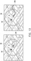
- FIG. 13 shows two examples illustrating a region of interest corresponding to an application requirement.
- the user equipment 70 is located within a signal covering range SR of the relay station 50, and can receive the preprocessed message accordingly.
- a left section of the figure shows application requirements pertinent to vehicle safety real-time status and traffic information
- a right section of the figure shows application requirements pertinent to route planning. Regions of interest IR1 and IR2 corresponding to the two application requirements are of different shapes.
- the processor 75 may determine the corresponding fourth identification information based on the region of interest corresponding to the application requirement.
- the fourth identification information replaces the identification information, and the location information of the region of interest (coordinates of a location of the covered region) replaces the location information of the initial message.
- the fourth identification information is also location information provided by the geographic information service and used to represent the region of interest. In this way, the user equipment 70 may classify the region of interest corresponding to its application requirement as a specific reference object.
- the second identification information may be the third identification information, the fourth identification information, or a combination thereof.
- the second identification information includes several pieces of sub-identification information (that is, the third identification information and/or the fourth identification information), and each piece of sub-identification information corresponds to the reference object defined by the geographic information service. That is, the second identification information may be a set of sub-identification information.
- FIG. 14 is a flowchart of a method for processing notification content according to an embodiment of the present disclosure.
- the processor 75 may determine whether the identification information matches the second identification information (step S1410), for example, whether the identifier or representative location information of the identification information is the same as the identifier or representative location information of the second identification information.
- the processor 75 processes the notification content (step S1430), for example, displays a warning message in notification content, determines a collision event, displays a traffic flow, or plans a navigation route.
- the processor 75 ignores the notification content (step S1450). For example, the processor 75 deletes the notification content/preprocessed message, stores the notification content/preprocessed message into the memory 73 or forwards the notification content/preprocessed message to another apparatus.
- the user equipment 70 may determine validity of the notification content by comparing the identification information, and quickly screen out the notification content that meets its own application requirements.
- the cartographic data type may be associated with the road, and the user equipment 70 can quickly exclude the messages that are outside the road.
- the identification information of the specific reference object may replace the location information of the initial message, the user equipment, or the region of interest (that is, the geocoding format is converted).
- the user equipment obtains a basis of determining whether to process the notification content.
- the application service server preliminarily converts the form of the location with respect to the initial message, and screens out the specific data type, thereby reducing the amount of computing of the user equipment, increasing efficiency of computing, and achieving a response speed that meets the application requirements.
Landscapes
- Engineering & Computer Science (AREA)
- Computer Networks & Wireless Communication (AREA)
- Signal Processing (AREA)
- Theoretical Computer Science (AREA)
- Databases & Information Systems (AREA)
- Physics & Mathematics (AREA)
- General Physics & Mathematics (AREA)
- Data Mining & Analysis (AREA)
- General Engineering & Computer Science (AREA)
- Remote Sensing (AREA)
- Multimedia (AREA)
- Life Sciences & Earth Sciences (AREA)
- Atmospheric Sciences (AREA)
- Navigation (AREA)
- Mobile Radio Communication Systems (AREA)
Claims (32)
- Regionsbasiertes Informationsverarbeitungsverfahren, umfassend:Empfangen einer Anfangsnachricht, wobei die Anfangsnachricht einen Benachrichtigungsinhalt umfasst, der Standortinformationen entspricht, und die Standortinformationen durch ein geographisches Koordinatensystem definiert sind;Bestimmen von Identifikationsinformationen gemäß den Standortinformationen, wobei die Identifikationsinformationen von einem geographischen Informationsdienst bereitgestellt werden, wobeidie Identifikationsinformationen ein kartographisches Datenattribut sind, das durch den geographischen Informationsdienst definiert ist, und dass der Schritt des Bestimmens der Identifikationsinformationen weiterhin umfasst:Bereitstellen mehrerer Referenzobjekte, wobei jedes der Referenzobjekte eine entsprechende der Identifikationsinformationen aufweist;Bestimmen, entsprechend einer Abstandsbeziehung zwischen den Standortinformationen und mindestens einem übereinstimmenden Referenzobjekt, ob die Standortinformationen zu einem kartographischen Datentyp der Referenzobjekte gehören; undAusschließen der Anfangsnachrichten, die nicht zum kartographischen Datentyp der Referenzobjekte gehören; und Ersetzen der Standortinformationen der Anfangsnachricht durch die Identifikationsinformationen des mindestens einen übereinstimmenden Referenzobjekts, um eine vorverarbeitete Nachricht zu erzeugen, wobei die vorverarbeitete Nachricht die Identifikationsinformationen und den Benachrichtigungsinhalt umfasst und die Identifikationsinformationen des mindestens einen übereinstimmenden Referenzobjekts die durch das geographische Koordinatensystem definierten Standortinformationen darstellen.
- Regionsbasiertes Informationsverarbeitungsverfahren gemäß Anspruch 1, wobei das kartographische Datenattribut einen Identifikator und entsprechende repräsentative Standortinformationen umfasst, die repräsentativen Standortinformationen mit dem geographischen Koordinatensystem assoziiert sind, jedes der Referenzobjekte ferner einen entsprechenden Identifikator und entsprechende repräsentative Standortinformationen aufweist, und der Schritt des Bestimmens der Identifikationsinformationen gemäß den Standortinformationen umfasst:Bestimmen des mindestens einen Referenzobjekts, das mit den Standortinformationen übereinstimmt; undBestimmen der Identifikationsinformationen entsprechend der Abstandsbeziehung zwischen den Standortinformationen und dem mindestens einen übereinstimmenden Referenzobjekt.
- Regionsbasiertes Informationsverarbeitungsverfahren gemäß Anspruch 2, wobeials Reaktion darauf, dass die Standortinformationen zu dem kartographischen Datentyp gehören, die dem kartographischen Datentyp entsprechenden Identifikationsinformationen erzeugt werden, undals Reaktion darauf, dass die Standortinformationen nicht zum kartografischen Datentyp gehören, die dem kartografischen Datentyp entsprechenden Identifikationsinformationen nicht erzeugt werden.
- Regionsbasiertes Informationsverarbeitungsverfahren gemäß Anspruch 2, wobei die Abstandsbeziehung einen vertikalen Abstand umfasst, und der Schritt des Bestimmens der Identifikationsinformationen umfasst:jeweils Bestimmen des vertikalen Abstands von jedem übereinstimmenden Referenzobjekt zu einem Standort, der den Standortinformationen entspricht; undAuswählen mindestens eines Referenzobjekts unter den mindestens einen übereinstimmenden Referenzobjekten, das einem kürzesten vertikalen Abstand entspricht, wobei die Identifikationsinformationen, die den Standortinformationen entsprechen, mit Identifikationsinformationen des ausgewählten mindestens einen Referenzobjekts assoziiert sind.
- Regionsbasiertes Informationsverarbeitungsverfahren gemäß Anspruch 4, wobei die Abstandsbeziehung ferner eine Beziehung zwischen dem vertikalen Abstand und einem Abdeckungsbereich umfasst, und der Schritt des Bestimmens der Identifikationsinformationen umfasst:Vergleichen des vertikalen Abstands, die dem ausgewählten mindestens einen Referenzobjekt entspricht, mit dem Abdeckungsbereich; undBestimmen der Identifikationsinformationen gemäß einem Vergleichsergebnis, wobei das Vergleichsergebnis darin besteht, dass der vertikale Abstand innerhalb des Abdeckungsbereichs liegt.
- Regionsbasiertes Informationsverarbeitungsverfahren gemäß Anspruch 4, wobei die repräsentative Standortinformationen jedes Referenzobjekts durch mindestens zwei Knoten (312, 612-1, 612-2, 612-3) innerhalb eines Bereichs des Referenzobjekts bestimmt wird, und der Schritt des jeweiligen Bestimmens des vertikalen Abstands von jedem übereinstimmenden Referenzobjekt zu dem den Standortinformationen entsprechenden Standort umfasst:jeweils Bilden mindestens einer Referenzgerade (613-1, 613-2, 613-3) entsprechend den mindestens zwei Knoten (312, 612-1, 612-2, 612-3) in dem mindestens einen übereinstimmenden Referenzobjekt, wobei jede Referenzgerade (613-1, 613-2, 613-3) durch die entsprechenden mindestens zwei Knoten (312, 612-1, 612-2, 612-3) verläuft; undjeweils Bestimmen des entsprechenden vertikalen Abstands von dem den Standortinformationen entsprechenden Standort zu der mindestens einen Bezugsgeraden (613-1, 613-2, 613-3).
- Regionsbasiertes Informationsverarbeitungsverfahren gemäß Anspruch 3, wobei der kartographische Datentyp der Referenzobjekte eine Straße ist.
- Regionsbasiertes Informationsverarbeitungsverfahren gemäß Anspruch 2, wobei der Schritt des Bestimmens des mindestens einen Referenzobjekts, das mit den Standortinformationen übereinstimmt, umfasst:
Verwenden mindestens eines Referenzobjekts innerhalb eines Suchbereichs, entsprechend den Standortinformationen, als das mindestens eine übereinstimmende Referenzobjekt. - Regionsbasiertes Informationsverarbeitungsverfahren gemäß Anspruch 8, wobei mindestens zwei Knoten (312, 612-1, 612-2, 612-3) in einem Bereich jedes Referenzobjekts enthalten sind und das Verfahren vor dem Schritt des Verwendens des mindestens einen Referenzobjekts innerhalb des Suchbereichs, der den Standortinformationen entspricht, als das mindestens eine übereinstimmende Referenzobjekt weiterhin umfasst:
jeweils Bilden einer Knotengruppe (620-1, 620-2, 620-3) gemäß mindestens zwei Knoten (312, 612-1, 612-2, 612-3) in jedem Referenzobjekt, die am nächsten an einem Standort liegen, der den Standortinformationen entspricht, wobei jede Knotengruppe (620-1, 620-2, 620-3) verwendet wird, um den Suchbereich zu vergleichen. - Regionsbasiertes Informationsverarbeitungsverfahren gemäß Anspruch 1, ferner umfassend:Laden von Karteninformationen, die von dem geographischen Informationsdienst bereitgestellt werden, wobei die Karteninformationen mit kartographischen Datenattributen von mehreren Referenzobjekten assoziiert sind, jedes kartographische Datenattribut zweite Standortinformationen umfasst und die zweiten Standortinformationen durch das geographische Koordinatensystem definiert sind; undjeweils Umwandeln der zweiten Standortinformationen der Referenzobjekte in entsprechende repräsentative Standortinformationen, wobei jeder Teil der repräsentativen Standortinformationen in einer Indexform vorliegt.
- Anwendungsdienst-Server (30), umfassend:einen Kommunikationstransceiver (31), der zum Übertragen oder Empfangen eines Signals konfiguriert ist; undeinen Prozessor (35), der mit dem Kommunikationstransceiver (31) gekoppelt und so konfiguriert ist zum:Empfangen einer Anfangsnachricht durch den Kommunikationstransceiver (31), wobei die Anfangsnachricht einen Benachrichtigungsinhalt umfasst, der Standortinformationen entspricht, und die Standortinformationen durch ein geographisches Koordinatensystem definiert sind;Bestimmen von Identifikationsinformationen gemäß den Standortinformationen, wobei die Identifikationsinformationen von einem geographischen Informationsdienst bereitgestellt werden, wobeidie Identifikationsinformationen ein kartographisches Datenattribut sind, das durch den geographischen Informationsdienst definiert ist, und der Prozessor (35) weiter konfiguriert ist zum:
Bereitstellen mehrerer Referenzobjekte, wobei jedes der Referenzobjekte eine entsprechende der Identifikationsinformationen aufweist;Bestimmen, entsprechend einer Abstandsbeziehung zwischen den Standortinformationen und mindestens einem übereinstimmenden Referenzobjekt, ob die Standortinformationen zu einem kartographischen Datentyp der Referenzobjekte gehören; undAusschließen der Anfangsnachrichten, die nicht zum kartographischen Datentyp der Referenzobjekte gehören; undErsetzen der Standortinformationen der Anfangsnachricht durch die Identifikationsinformationen des mindestens einen übereinstimmenden Referenzobjekts, um eine vorverarbeitete Nachricht zu erzeugen, wobei die vorverarbeitete Nachricht die Identifikationsinformationen und den Benachrichtigungsinhalt umfasst und die Identifikationsinformationen des mindestens einen übereinstimmenden Referenzobjekts die durch das geographische Koordinatensystem definierten Standortinformationen darstellen. - Anwendungsdienst-Server (30) gemäß Anspruch 11, wobei das kartographische Datenattribut einen Identifikator und entsprechende repräsentative Standortinformationen umfasst, die repräsentativen Standortinformationen mit dem geographischen Koordinatensystem assoziiert sind, jedes der Referenzobjekte ferner einen entsprechenden Identifikator und entsprechende repräsentative Standortinformationen aufweist, und der Prozessor (35) so konfiguriert ist zum:Bestimmen des mindestens einen Referenzobjekts, das mit den Standortinformationen übereinstimmt; undBestimmen der Identifikationsinformationen entsprechend der Abstandsbeziehung zwischen den Standortinformationen und dem mindestens einen übereinstimmenden Referenzobjekt.
- Anwendungsdienst-Server (30) gemäß Anspruch 12, wobeials Reaktion auf die zu dem kartographischen Datentyp gehörenden Standortinformationen der Prozessor (35) die dem kartographischen Datentyp entsprechenden Identifikationsinformationen erzeugt, undals Reaktion darauf, dass die Standortinformationen nicht zum kartographischen Datentyp gehören, der Prozessor (35) die Identifikationsinformationen, die dem kartographischen Datentyp entsprechen, nicht erzeugt.
- Anwendungsdienst-Server (30) gemäß Anspruch 12, wobei die Abstandsbeziehung einen vertikalen Abstand umfasst und der Prozessor (35) konfiguriert ist zum:jeweils Bestimmen des vertikalen Abstands von jedem übereinstimmenden Referenzobjekt zu einem Standort, der den Standortinformationen entspricht; undAuswählen mindestens eines Referenzobjekts unter den mindestens einen übereinstimmenden Referenzobjekten, das einem kürzesten vertikalen Abstand entspricht, wobei die Identifikationsinformationen, die den Standortinformationen entsprechen, mit Identifikationsinformationen des ausgewählten mindestens einen Referenzobjekts assoziiert sind.
- Anwendungsdienst-Server (30) gemäß Anspruch 14, wobei die Abstandsbeziehung ferner eine Beziehung zwischen dem vertikalen Abstand und einem Abdeckungsbereich umfasst, und der Prozessor (35) so konfiguriert ist zum:Vergleichen des vertikalen Abstands, die dem ausgewählten mindestens einen Referenzobjekt entspricht, mit dem Abdeckungsbereich; undBestimmen der Identifikationsinformationen gemäß einem Vergleichsergebnis, wobei das Vergleichsergebnis darin besteht, dass der vertikale Abstand innerhalb des Abdeckungsbereichs liegt.
- Anwendungsdienst-Server (30) gemäß Anspruch 14, wobei die repräsentativen Standortinformationen jedes Referenzobjekts von mindestens zwei Knoten (312, 612-1, 612-2, 612-3) innerhalb eines Bereichs des Referenzobjekts bestimmt werden, und der Prozessor (35) konfiguriert ist zum:jeweils Bilden mindestens einer Referenzgerade (613-1, 613-2, 613-3) entsprechend den mindestens zwei Knoten (312, 612-1, 612-2, 612-3) in dem mindestens einen übereinstimmenden Referenzobjekt, wobei jede Referenzgerade (613-1, 613-2, 613-3) durch die entsprechenden mindestens zwei Knoten (312, 612-1, 612-2, 612-3) verläuft; undjeweils Bestimmen des entsprechenden vertikalen Abstands von dem den Standortinformationen entsprechenden Standort zu der mindestens einen Bezugsgeraden (613-1, 613-2, 613-3).
- Anwendungsdienst-Server (30) gemäß Anspruch 13, wobei der kartographische Datentyp der Referenzobjekte eine Straße ist.
- Anwendungsdienst-Server (30) gemäß Anspruch 12, wobei der Prozessor (35) konfiguriert ist zum:
Verwenden mindestens eines Referenzobjekts innerhalb eines Suchbereichs, entsprechend den Standortinformationen, als das mindestens eine übereinstimmende Referenzobjekt. - Anwendungsdienst-Server (30) gemäß Anspruch 18, wobei mindestens zwei Knoten (312, 612-1, 612-2, 612-3) in einem Bereich jedes Referenzobjekts enthalten sind und der Prozessor (35) konfiguriert ist zum:
jeweils Bilden einer Knotengruppe (620-1, 620-2, 620-3) gemäß mindestens zwei Knoten (312, 612-1, 612-2, 612-3) in jedem Referenzobjekt, die am nächsten an einem Standort liegen, der den Standortinformationen entspricht, wobei jede Knotengruppe (620-1, 620-2, 620-3) verwendet wird, um den Suchbereich zu vergleichen. - Anwendungsdienst-Server (30) gemäß Anspruch 11, wobei der Prozessor (35) konfiguriert ist zum:Laden von Karteninformationen, die von dem geographischen Informationsdienst bereitgestellt werden, wobei die Karteninformationen mit kartographischen Datenattributen von mehreren Referenzobjekten assoziiert sind, jedes kartographische Datenattribut zweite Standortinformationen umfasst und die zweiten Standortinformationen durch das geographische Koordinatensystem definiert sind; undjeweils Umwandeln der zweiten Standortinformationen der Referenzobjekte in entsprechende repräsentative Standortinformationen, wobei jeder Teil der repräsentativen Standortinformationen in einer Indexform vorliegt.
- Anwendungsdienst-Server (30) gemäß Anspruch 11, wobei der Prozessor (35) konfiguriert ist zum:
Übertragen der vorverarbeitete Nachricht durch den Kommunikationstransceiver (31), wobei die vorverarbeitete Nachricht dazu verwendet wird, die Identifikationsinformationen bereitzustellen, um den Vergleich der Standortinformationen zu ersetzen. - Benutzergerät (70), umfassend:einen Kommunikationstransceiver (71), der zum Übertragen oder Empfangen eines Signals konfiguriert ist;einen Prozessor (75), der mit dem Kommunikationstransceiver (71) gekoppelt und konfiguriert ist zum:Empfangen einer vorverarbeiteten Nachricht über den Kommunikationstransceiver (71), wobei die vorverarbeitete Nachricht Identifikationsinformationen und einen Benachrichtigungsinhalt umfasst und die Identifikationsinformationen von einem geographischen Informationsdienst bereitgestellt werden und verwendet werden, um durch ein geographisches Koordinatensystem definierte Standortinformationen darzustellen; undVerarbeiten des Benachrichtigungsinhalts gemäß einem Vergleichsergebnis zwischen den Identifikationsinformationen und zweiten Identifikationsinformationen, wobei die zweiten Identifikationsinformationen von dem geographischen Informationsdienst bereitgestellt werden und verwendet werden, um eine Region von Interesse für das Benutzergerät (70) darzustellen; undeine Positionierungssteuerung (77), die mit dem Prozessor (75) gekoppelt und so konfiguriert ist, dass sie Standortinformationen des Benutzergeräts (70) erhält, wobei die Standortinformationen des Benutzergeräts (70) durch das geografische Koordinatensystem definiert sind, wobei der Schritt des Verarbeitens des Benachrichtigungsinhalts ferner umfasst:
Bestimmen dritter Identifikationsinformationen gemäß den Standortinformationen des Benutzergeräts (70), wobei die dritten Identifikationsinformationen von dem geographischen Informationsdienst bereitgestellt und verwendet werden, um die Standortinformationen des Benutzergeräts (70) darzustellen, wobei die dritten Identifikationsinformationen ein kartographisches Datenattribut sind, das von dem geographischen Informationsdienst definiert wird, wobei das kartographische Datenattribut einen Identifikator und entsprechende repräsentative Standortinformationen umfasst, wobei die repräsentativen Standortinformationen mit dem geographischen Koordinatensystem assoziiert sind, und wobei der Vorgang des Bestimmens der Identifikationsinformationen gemäß den Standortinformationen umfasst:Bereitstellen mehrerer Referenzobjekte, wobei jedes der Referenzobjekte, das mit den Standortinformationen übereinstimmt; undBestimmen der dritten Identifikationsinformationen gemäß einer Abstandsbeziehung zwischen den Standortinformationen des Benutzergeräts (70) und dem mindestens einen übereinstimmenden Referenzobjekt;Bestimmen der zweiten Identifikationsinformationen gemäß einer Anwendungsanforderung und den dritten Identifikationsinformationen;
und
Ausschließen des Benachrichtigungsinhalts als Reaktion auf das Vergleichsergebnis, dass die Identifikationsinformationen nicht mit den zweiten Identifikationsinformationen übereinstimmen. - Benutzergerät (70) gemäß Anspruch 22, wobei der Prozessor (75) konfiguriert ist zum:Verarbeiten des Benachrichtigungsinhalts in Reaktion auf das Vergleichsergebnis, dass die Identifikationsinformationen mit den zweiten Identifikationsinformationen übereinstimmen; undIgnorieren des Benachrichtigungsinhalts als Reaktion auf das Vergleichsergebnis, dass die Identifikationsinformationen nicht mit den zweiten Identifikationsinformationen übereinstimmen.
- Benutzergerät (70) gemäß Anspruch 22, wobei die zweiten Identifikationsinformationen mehrere Teile von Sub-Identifikationsinformationen umfassen und jeder Teil der Sub-Identifikationsinformationen einem durch den geografischen Informationsdienst definierten Referenzobjekt entspricht.
- Benutzergerät (70) gemäß Anspruch 22, wobei der Prozessor (75) konfiguriert ist zum:Bestimmen, entsprechend der Abstandsbeziehung, ob die Standortinformationen zum kartographischen Datentyp der Referenzobjekte gehören, wobeials Reaktion darauf, dass die Standortinformationen zum kartographischen Datentyp gehören, der Prozessor (75) die dritte Identifikationsinformationen erzeugt, die dem kartographischen Datentyp entsprechen, undals Reaktion darauf, dass die Standortinformationen nicht zum kartographischen Datentyp gehören, der Prozessor (75) die dritten Identifikationsinformationen nicht erzeugt, die dem kartographischen Datentyp entsprechen.
- Benutzergerät (70) gemäß Anspruch 22, wobei die Abstandsbeziehung einen vertikalen Abstand umfasst, und der Prozessor (75) konfiguriert ist zum:jeweils Bestimmen des vertikalen Abstands von jedem übereinstimmenden Referenzobjekt zu einem Standort, der den Standortinformationen des Benutzergeräts (70) entspricht; undAuswählen mindestens eines Referenzobjekts unter den mindestens einen übereinstimmenden Referenzobjekten, das einem kürzesten vertikalen Abstand entspricht, wobei die Identifikationsinformationen, die den Standortinformationen entsprechen, mit Identifikationsinformationen des ausgewählten mindestens einen Referenzobjekts assoziiert sind.
- Benutzergerät (70) gemäß Anspruch 26, wobei die Abstandsbeziehung ferner eine Beziehung zwischen dem vertikalen Abstand und einem Abdeckungsbereich umfasst, und der Prozessor (75) konfiguriert ist zum:Vergleichen des vertikalen Abstands, die dem ausgewählten mindestens einen Referenzobjekt entspricht, mit dem Abdeckungsbereich; undBestimmen der Identifikationsinformationen gemäß einem Vergleichsergebnis, wobei das Vergleichsergebnis darin besteht, dass der vertikale Abstand innerhalb des Abdeckungsbereichs liegt.
- Benutzergerät (70) gemäß Anspruch 26, wobei die repräsentativen Standortinformationen jedes Referenzobjekts von mindestens zwei Knoten (312, 612-1, 612-2, 612-3) innerhalb eines Bereichs des Referenzobjekts bestimmt werden und der Prozessor (75) konfiguriert ist zum:jeweils Bilden mindestens einer Referenzgerade (613-1, 613-2, 613-3) entsprechend den mindestens zwei Knoten (312, 612-1, 612-2, 612-3) in dem mindestens einen übereinstimmenden Referenzobjekt, wobei jede Referenzgerade (613-1, 613-2, 613-3) durch die entsprechenden mindestens zwei Knoten (312, 612-1, 612-2, 612-3) verläuft; undjeweils Bestimmen des entsprechenden vertikalen Abstands von dem den Standortinformationen des Benutzergeräts (70) entsprechenden Standort zu der mindestens einen Bezugsgeraden (613-1, 613-2, 613-3).
- Benutzergerät (70) gemäß Anspruch 25, wobei der kartographische Datentyp der Referenzobjekte eine Straße ist.
- Benutzergerät (70) gemäß Anspruch 22, wobei der Prozessor (75) konfiguriert ist zum:
Verwenden mindestens eines Referenzobjekts innerhalb eines Suchbereichs, entsprechend den Standortinformationen, als das mindestens eine übereinstimmende Referenzobjekt. - Benutzergerät (70) gemäß Anspruch 30, wobei mindestens zwei Knoten (312, 612-1, 612-2, 612-3) in einem Bereich jedes Referenzobjekts enthalten sind und der Prozessor (75) konfiguriert ist zum:
jeweils Bilden einer Knotengruppe (620-1, 620-2, 620-3) gemäß mindestens zwei Knoten (312, 612-1, 612-2, 612-3) in jedem Referenzobjekt, die am nächsten an einem Standort liegen, der den Standortinformationen des Benutzergeräts (70) entspricht, wobei jede Knotengruppe (620-1, 620-2, 620-3) verwendet wird, um den Suchbereich zu vergleichen. - Benutzergerät (70) gemäß Anspruch 22, wobei der Prozessor (75) konfiguriert ist zum:Laden von Karteninformationen, die von dem geographischen Informationsdienst bereitgestellt werden, wobei die Karteninformationen mit kartographischen Datenattributen von mehreren Referenzobjekten assoziiert sind, jedes kartographische Datenattribut zweite Standortinformationen umfasst und die zweiten Standortinformationen durch das geographische Koordinatensystem definiert sind; undjeweils Umwandeln der zweiten Standortinformationen der Referenzobjekte in entsprechende repräsentative Standortinformationen, wobei jeder Teil der repräsentativen Standortinformationen in einer Indexform vorliegt.
Applications Claiming Priority (1)
| Application Number | Priority Date | Filing Date | Title |
|---|---|---|---|
| TW109112664A TWI744861B (zh) | 2020-04-15 | 2020-04-15 | 應用服務伺服器、基於地域的資訊處理方法及使用者設備 |
Publications (2)
| Publication Number | Publication Date |
|---|---|
| EP3897002A1 EP3897002A1 (de) | 2021-10-20 |
| EP3897002B1 true EP3897002B1 (de) | 2024-05-01 |
Family
ID=71083482
Family Applications (1)
| Application Number | Title | Priority Date | Filing Date |
|---|---|---|---|
| EP20179154.8A Active EP3897002B1 (de) | 2020-04-15 | 2020-06-10 | Anwendungsdienstserver, regionsbasiertes informationsverarbeitungsverfahren und benutzergerät |
Country Status (4)
| Country | Link |
|---|---|
| US (1) | US11284220B2 (de) |
| EP (1) | EP3897002B1 (de) |
| CN (1) | CN113543025B (de) |
| TW (1) | TWI744861B (de) |
Family Cites Families (24)
| Publication number | Priority date | Publication date | Assignee | Title |
|---|---|---|---|---|
| US8207964B1 (en) * | 2008-02-22 | 2012-06-26 | Meadow William D | Methods and apparatus for generating three-dimensional image data models |
| JP4941274B2 (ja) | 2007-12-20 | 2012-05-30 | 株式会社Jvcケンウッド | 路車間通信システム |
| US8126748B2 (en) | 2008-02-25 | 2012-02-28 | Tixtrack, Inc. | Sports and concert event ticket pricing and visualization system |
| US7659848B2 (en) | 2008-04-29 | 2010-02-09 | Geotate B.V. | Event location determination |
| US9384491B1 (en) | 2009-08-19 | 2016-07-05 | Allstate Insurance Company | Roadside assistance |
| US20120262289A1 (en) * | 2011-03-31 | 2012-10-18 | French Ii Kenneth Robert | Security systems having portable monitoring devices and methods using same |
| US9485623B2 (en) * | 2011-08-18 | 2016-11-01 | Rivada Research, Llc | Method and system for providing enhanced location based trilateration |
| TWM445233U (zh) | 2012-05-31 | 2013-01-11 | Shu-Mao Lin | 行人安全警示裝置 |
| CN102932737B (zh) * | 2012-10-24 | 2017-07-25 | 广州中道电子科技有限公司 | 一种获取位置信息的方法、装置和系统 |
| CN104077311B (zh) * | 2013-03-28 | 2017-11-14 | 国际商业机器公司 | 车辆位置索引方法及装置 |
| US9736674B2 (en) * | 2013-06-03 | 2017-08-15 | Lg Electronics Inc. | Discovery signal transmission method of terminal performing D2D communication and terminal using same |
| GB201421441D0 (en) * | 2014-12-02 | 2015-01-14 | Tomtom Int Bv | Method and apparatus for providing point of interest information |
| US9945689B2 (en) * | 2015-08-25 | 2018-04-17 | Here Global B.V. | Location referencing for roadway feature data |
| US9903733B2 (en) | 2016-03-17 | 2018-02-27 | Honda Motor Co., Ltd. | Vehicular communications network and methods of use and manufacture thereof |
| WO2017196152A2 (ko) * | 2016-05-13 | 2017-11-16 | 엘지전자 주식회사 | 무선 통신 시스템에서 차량 단말의 지리 정보를 보고하는 방법 및 장치 |
| US10081357B2 (en) | 2016-06-23 | 2018-09-25 | Honda Motor Co., Ltd. | Vehicular communications network and methods of use and manufacture thereof |
| CN108700428B (zh) * | 2017-03-01 | 2021-06-01 | 华为技术有限公司 | 电子地图中道路的绘制方法及装置 |
| TWI622025B (zh) | 2017-05-24 | 2018-04-21 | 財團法人工業技術研究院 | 弱勢用路人的訊息傳輸方法及其行動裝置與系統 |
| CN107395313B (zh) * | 2017-07-24 | 2019-04-30 | 中国联合网络通信集团有限公司 | 一种减少小区间干扰的方法及装置 |
| CN109996187A (zh) | 2017-12-29 | 2019-07-09 | 财团法人工业技术研究院 | 行动边缘平台服务器及其车联网服务的装置与信息管理方法 |
| US10551477B2 (en) | 2018-03-28 | 2020-02-04 | Qualcomm Incorporated | Method and apparatus for V2X assisted positioning determination using positioning reference signal signals |
| CN110942652A (zh) * | 2018-09-21 | 2020-03-31 | 阿里巴巴集团控股有限公司 | 一种输出道路标识信息的方法及装置 |
| TWM578665U (zh) | 2019-01-10 | 2019-06-01 | 施博瀚 | Human car travel smart collision warning system |
| CN110909759B (zh) * | 2019-10-10 | 2020-12-18 | 重庆特斯联智慧科技股份有限公司 | 基于人口大数据的城市区域分级管理系统及方法 |
-
2020
- 2020-04-15 TW TW109112664A patent/TWI744861B/zh active
- 2020-05-22 CN CN202010442817.XA patent/CN113543025B/zh active Active
- 2020-06-04 US US16/892,296 patent/US11284220B2/en active Active
- 2020-06-10 EP EP20179154.8A patent/EP3897002B1/de active Active
Also Published As
| Publication number | Publication date |
|---|---|
| TW202142006A (zh) | 2021-11-01 |
| US20210329413A1 (en) | 2021-10-21 |
| TWI744861B (zh) | 2021-11-01 |
| US11284220B2 (en) | 2022-03-22 |
| CN113543025A (zh) | 2021-10-22 |
| EP3897002A1 (de) | 2021-10-20 |
| CN113543025B (zh) | 2024-07-19 |
Similar Documents
| Publication | Publication Date | Title |
|---|---|---|
| CN113256976B (zh) | 一种车路协同系统、模拟仿真方法、车载设备和路侧设备 | |
| US11669653B2 (en) | Simulated vehicle traffic for autonomous vehicles | |
| CN113498011B (zh) | 车联网方法、装置、设备、存储介质及系统 | |
| CN105788328B (zh) | 一种用于智能交通的路侧设备和通过路侧设备实现智能交通的方法 | |
| JP2018182661A (ja) | 通信システム、車両搭載器及びプログラム | |
| KR20200040501A (ko) | 교통 정보 예측 방법, 장치 및 컴퓨터 프로그램 | |
| Chen et al. | BIG-CCA: Beacon-less, infrastructure-less, and GPS-less cooperative collision avoidance based on vehicular sensor networks | |
| Hattarge et al. | LoRaWAN based GPS tracking of city-buses for smart public transport system | |
| WO2022206322A1 (zh) | 一种通信方法及通信装置 | |
| Celaya-Echarri et al. | Building decentralized fog computing-based smart parking systems: from deterministic propagation modeling to practical deployment | |
| US11645913B2 (en) | System and method for location data fusion and filtering | |
| US10154393B2 (en) | Method, motor vehicle, and system for determining a transmission path | |
| Song et al. | First mile: An open innovation lab for infrastructure-assisted cooperative intelligent transportation systems | |
| KR20230037277A (ko) | 현장내 스마트 운송차량 운행관리 시스템 | |
| CN107454553A (zh) | 用于检测移动设备的测量结果的方法、装置和计算机程序 | |
| EP3897002B1 (de) | Anwendungsdienstserver, regionsbasiertes informationsverarbeitungsverfahren und benutzergerät | |
| Rapelli et al. | OScar: An ETSI-Compliant C-ITS Stack for Field-Testing with Embedded Hardware Devices | |
| Kanchanasut et al. | Internet of cars through commodity V2V and V2X mobile routers: applications for developing countries | |
| KR102739468B1 (ko) | 교통 정보를 생성하는 서버, 방법 및 컴퓨터 프로그램 | |
| US20240159563A1 (en) | Map data processing method and apparatus | |
| CN119358980A (zh) | 一种定位优化的扫码通信救援管理方法及系统 | |
| WO2023197651A1 (zh) | 信息处理方法及相关装置、系统 | |
| KR102622811B1 (ko) | V2x 메시지 전송 장치 및 방법 | |
| KR20230037276A (ko) | 현장내 스마트 운송차량 운행관리 시스템 | |
| Ben Khadra | Road Traffic Management using Vehicle-to-Everything (V2X) Communication |
Legal Events
| Date | Code | Title | Description |
|---|---|---|---|
| STAA | Information on the status of an ep patent application or granted ep patent |
Free format text: STATUS: EXAMINATION IS IN PROGRESS |
|
| PUAI | Public reference made under article 153(3) epc to a published international application that has entered the european phase |
Free format text: ORIGINAL CODE: 0009012 |
|
| 17P | Request for examination filed |
Effective date: 20200610 |
|
| AK | Designated contracting states |
Kind code of ref document: A1 Designated state(s): AL AT BE BG CH CY CZ DE DK EE ES FI FR GB GR HR HU IE IS IT LI LT LU LV MC MK MT NL NO PL PT RO RS SE SI SK SM TR |
|
| B565 | Issuance of search results under rule 164(2) epc |
Effective date: 20200902 |
|
| REG | Reference to a national code |
Ref legal event code: R079 Ipc: G08G0001096700 Ref country code: DE Ref legal event code: R079 Ref document number: 602020029945 Country of ref document: DE Free format text: PREVIOUS MAIN CLASS: H04W0004021000 Ipc: G08G0001096700 |
|
| GRAP | Despatch of communication of intention to grant a patent |
Free format text: ORIGINAL CODE: EPIDOSNIGR1 |
|
| RIC1 | Information provided on ipc code assigned before grant |
Ipc: H04W 4/40 20180101ALI20240103BHEP Ipc: H04W 4/02 20180101ALI20240103BHEP Ipc: H04W 4/021 20180101ALI20240103BHEP Ipc: G08G 1/0967 20060101AFI20240103BHEP |
|
| STAA | Information on the status of an ep patent application or granted ep patent |
Free format text: STATUS: GRANT OF PATENT IS INTENDED |
|
| INTG | Intention to grant announced |
Effective date: 20240208 |
|
| GRAS | Grant fee paid |
Free format text: ORIGINAL CODE: EPIDOSNIGR3 |
|
| GRAA | (expected) grant |
Free format text: ORIGINAL CODE: 0009210 |
|
| STAA | Information on the status of an ep patent application or granted ep patent |
Free format text: STATUS: THE PATENT HAS BEEN GRANTED |
|
| P01 | Opt-out of the competence of the unified patent court (upc) registered |
Effective date: 20240305 |
|
| AK | Designated contracting states |
Kind code of ref document: B1 Designated state(s): AL AT BE BG CH CY CZ DE DK EE ES FI FR GB GR HR HU IE IS IT LI LT LU LV MC MK MT NL NO PL PT RO RS SE SI SK SM TR |
|
| REG | Reference to a national code |
Ref country code: GB Ref legal event code: FG4D |
|
| REG | Reference to a national code |
Ref country code: CH Ref legal event code: EP |
|
| REG | Reference to a national code |
Ref country code: IE Ref legal event code: FG4D |
|
| REG | Reference to a national code |
Ref country code: DE Ref legal event code: R096 Ref document number: 602020029945 Country of ref document: DE |
|
| REG | Reference to a national code |
Ref country code: LT Ref legal event code: MG9D |
|
| REG | Reference to a national code |
Ref country code: NL Ref legal event code: MP Effective date: 20240501 |
|
| PG25 | Lapsed in a contracting state [announced via postgrant information from national office to epo] |
Ref country code: IS Free format text: LAPSE BECAUSE OF FAILURE TO SUBMIT A TRANSLATION OF THE DESCRIPTION OR TO PAY THE FEE WITHIN THE PRESCRIBED TIME-LIMIT Effective date: 20240901 |
|
| PG25 | Lapsed in a contracting state [announced via postgrant information from national office to epo] |
Ref country code: BG Free format text: LAPSE BECAUSE OF FAILURE TO SUBMIT A TRANSLATION OF THE DESCRIPTION OR TO PAY THE FEE WITHIN THE PRESCRIBED TIME-LIMIT Effective date: 20240501 |
|
| PG25 | Lapsed in a contracting state [announced via postgrant information from national office to epo] |
Ref country code: HR Free format text: LAPSE BECAUSE OF FAILURE TO SUBMIT A TRANSLATION OF THE DESCRIPTION OR TO PAY THE FEE WITHIN THE PRESCRIBED TIME-LIMIT Effective date: 20240501 Ref country code: FI Free format text: LAPSE BECAUSE OF FAILURE TO SUBMIT A TRANSLATION OF THE DESCRIPTION OR TO PAY THE FEE WITHIN THE PRESCRIBED TIME-LIMIT Effective date: 20240501 |
|
| PG25 | Lapsed in a contracting state [announced via postgrant information from national office to epo] |
Ref country code: GR Free format text: LAPSE BECAUSE OF FAILURE TO SUBMIT A TRANSLATION OF THE DESCRIPTION OR TO PAY THE FEE WITHIN THE PRESCRIBED TIME-LIMIT Effective date: 20240802 |
|
| PG25 | Lapsed in a contracting state [announced via postgrant information from national office to epo] |
Ref country code: PT Free format text: LAPSE BECAUSE OF FAILURE TO SUBMIT A TRANSLATION OF THE DESCRIPTION OR TO PAY THE FEE WITHIN THE PRESCRIBED TIME-LIMIT Effective date: 20240902 |
|
| REG | Reference to a national code |
Ref country code: AT Ref legal event code: MK05 Ref document number: 1683496 Country of ref document: AT Kind code of ref document: T Effective date: 20240501 |
|
| PG25 | Lapsed in a contracting state [announced via postgrant information from national office to epo] |
Ref country code: NL Free format text: LAPSE BECAUSE OF FAILURE TO SUBMIT A TRANSLATION OF THE DESCRIPTION OR TO PAY THE FEE WITHIN THE PRESCRIBED TIME-LIMIT Effective date: 20240501 |
|
| PG25 | Lapsed in a contracting state [announced via postgrant information from national office to epo] |
Ref country code: ES Free format text: LAPSE BECAUSE OF FAILURE TO SUBMIT A TRANSLATION OF THE DESCRIPTION OR TO PAY THE FEE WITHIN THE PRESCRIBED TIME-LIMIT Effective date: 20240501 |
|
| PG25 | Lapsed in a contracting state [announced via postgrant information from national office to epo] |
Ref country code: AT Free format text: LAPSE BECAUSE OF FAILURE TO SUBMIT A TRANSLATION OF THE DESCRIPTION OR TO PAY THE FEE WITHIN THE PRESCRIBED TIME-LIMIT Effective date: 20240501 |
|
| PG25 | Lapsed in a contracting state [announced via postgrant information from national office to epo] |
Ref country code: PL Free format text: LAPSE BECAUSE OF FAILURE TO SUBMIT A TRANSLATION OF THE DESCRIPTION OR TO PAY THE FEE WITHIN THE PRESCRIBED TIME-LIMIT Effective date: 20240501 |
|
| PG25 | Lapsed in a contracting state [announced via postgrant information from national office to epo] |
Ref country code: LV Free format text: LAPSE BECAUSE OF FAILURE TO SUBMIT A TRANSLATION OF THE DESCRIPTION OR TO PAY THE FEE WITHIN THE PRESCRIBED TIME-LIMIT Effective date: 20240501 |
|
| PG25 | Lapsed in a contracting state [announced via postgrant information from national office to epo] |
Ref country code: PT Free format text: LAPSE BECAUSE OF FAILURE TO SUBMIT A TRANSLATION OF THE DESCRIPTION OR TO PAY THE FEE WITHIN THE PRESCRIBED TIME-LIMIT Effective date: 20240902 Ref country code: PL Free format text: LAPSE BECAUSE OF FAILURE TO SUBMIT A TRANSLATION OF THE DESCRIPTION OR TO PAY THE FEE WITHIN THE PRESCRIBED TIME-LIMIT Effective date: 20240501 Ref country code: NO Free format text: LAPSE BECAUSE OF FAILURE TO SUBMIT A TRANSLATION OF THE DESCRIPTION OR TO PAY THE FEE WITHIN THE PRESCRIBED TIME-LIMIT Effective date: 20240801 Ref country code: NL Free format text: LAPSE BECAUSE OF FAILURE TO SUBMIT A TRANSLATION OF THE DESCRIPTION OR TO PAY THE FEE WITHIN THE PRESCRIBED TIME-LIMIT Effective date: 20240501 Ref country code: LV Free format text: LAPSE BECAUSE OF FAILURE TO SUBMIT A TRANSLATION OF THE DESCRIPTION OR TO PAY THE FEE WITHIN THE PRESCRIBED TIME-LIMIT Effective date: 20240501 Ref country code: IS Free format text: LAPSE BECAUSE OF FAILURE TO SUBMIT A TRANSLATION OF THE DESCRIPTION OR TO PAY THE FEE WITHIN THE PRESCRIBED TIME-LIMIT Effective date: 20240901 Ref country code: HR Free format text: LAPSE BECAUSE OF FAILURE TO SUBMIT A TRANSLATION OF THE DESCRIPTION OR TO PAY THE FEE WITHIN THE PRESCRIBED TIME-LIMIT Effective date: 20240501 Ref country code: GR Free format text: LAPSE BECAUSE OF FAILURE TO SUBMIT A TRANSLATION OF THE DESCRIPTION OR TO PAY THE FEE WITHIN THE PRESCRIBED TIME-LIMIT Effective date: 20240802 Ref country code: FI Free format text: LAPSE BECAUSE OF FAILURE TO SUBMIT A TRANSLATION OF THE DESCRIPTION OR TO PAY THE FEE WITHIN THE PRESCRIBED TIME-LIMIT Effective date: 20240501 Ref country code: ES Free format text: LAPSE BECAUSE OF FAILURE TO SUBMIT A TRANSLATION OF THE DESCRIPTION OR TO PAY THE FEE WITHIN THE PRESCRIBED TIME-LIMIT Effective date: 20240501 Ref country code: BG Free format text: LAPSE BECAUSE OF FAILURE TO SUBMIT A TRANSLATION OF THE DESCRIPTION OR TO PAY THE FEE WITHIN THE PRESCRIBED TIME-LIMIT Effective date: 20240501 Ref country code: AT Free format text: LAPSE BECAUSE OF FAILURE TO SUBMIT A TRANSLATION OF THE DESCRIPTION OR TO PAY THE FEE WITHIN THE PRESCRIBED TIME-LIMIT Effective date: 20240501 Ref country code: RS Free format text: LAPSE BECAUSE OF FAILURE TO SUBMIT A TRANSLATION OF THE DESCRIPTION OR TO PAY THE FEE WITHIN THE PRESCRIBED TIME-LIMIT Effective date: 20240801 |
|
| PG25 | Lapsed in a contracting state [announced via postgrant information from national office to epo] |
Ref country code: DK Free format text: LAPSE BECAUSE OF FAILURE TO SUBMIT A TRANSLATION OF THE DESCRIPTION OR TO PAY THE FEE WITHIN THE PRESCRIBED TIME-LIMIT Effective date: 20240501 |
|
| PG25 | Lapsed in a contracting state [announced via postgrant information from national office to epo] |
Ref country code: EE Free format text: LAPSE BECAUSE OF FAILURE TO SUBMIT A TRANSLATION OF THE DESCRIPTION OR TO PAY THE FEE WITHIN THE PRESCRIBED TIME-LIMIT Effective date: 20240501 |
|
| PG25 | Lapsed in a contracting state [announced via postgrant information from national office to epo] |
Ref country code: CZ Free format text: LAPSE BECAUSE OF FAILURE TO SUBMIT A TRANSLATION OF THE DESCRIPTION OR TO PAY THE FEE WITHIN THE PRESCRIBED TIME-LIMIT Effective date: 20240501 |
|
| PG25 | Lapsed in a contracting state [announced via postgrant information from national office to epo] |
Ref country code: RO Free format text: LAPSE BECAUSE OF FAILURE TO SUBMIT A TRANSLATION OF THE DESCRIPTION OR TO PAY THE FEE WITHIN THE PRESCRIBED TIME-LIMIT Effective date: 20240501 Ref country code: SK Free format text: LAPSE BECAUSE OF FAILURE TO SUBMIT A TRANSLATION OF THE DESCRIPTION OR TO PAY THE FEE WITHIN THE PRESCRIBED TIME-LIMIT Effective date: 20240501 |
|
| PG25 | Lapsed in a contracting state [announced via postgrant information from national office to epo] |
Ref country code: SM Free format text: LAPSE BECAUSE OF FAILURE TO SUBMIT A TRANSLATION OF THE DESCRIPTION OR TO PAY THE FEE WITHIN THE PRESCRIBED TIME-LIMIT Effective date: 20240501 |
|
| PG25 | Lapsed in a contracting state [announced via postgrant information from national office to epo] |
Ref country code: SM Free format text: LAPSE BECAUSE OF FAILURE TO SUBMIT A TRANSLATION OF THE DESCRIPTION OR TO PAY THE FEE WITHIN THE PRESCRIBED TIME-LIMIT Effective date: 20240501 Ref country code: SK Free format text: LAPSE BECAUSE OF FAILURE TO SUBMIT A TRANSLATION OF THE DESCRIPTION OR TO PAY THE FEE WITHIN THE PRESCRIBED TIME-LIMIT Effective date: 20240501 Ref country code: RO Free format text: LAPSE BECAUSE OF FAILURE TO SUBMIT A TRANSLATION OF THE DESCRIPTION OR TO PAY THE FEE WITHIN THE PRESCRIBED TIME-LIMIT Effective date: 20240501 Ref country code: EE Free format text: LAPSE BECAUSE OF FAILURE TO SUBMIT A TRANSLATION OF THE DESCRIPTION OR TO PAY THE FEE WITHIN THE PRESCRIBED TIME-LIMIT Effective date: 20240501 Ref country code: DK Free format text: LAPSE BECAUSE OF FAILURE TO SUBMIT A TRANSLATION OF THE DESCRIPTION OR TO PAY THE FEE WITHIN THE PRESCRIBED TIME-LIMIT Effective date: 20240501 Ref country code: CZ Free format text: LAPSE BECAUSE OF FAILURE TO SUBMIT A TRANSLATION OF THE DESCRIPTION OR TO PAY THE FEE WITHIN THE PRESCRIBED TIME-LIMIT Effective date: 20240501 Ref country code: MC Free format text: LAPSE BECAUSE OF FAILURE TO SUBMIT A TRANSLATION OF THE DESCRIPTION OR TO PAY THE FEE WITHIN THE PRESCRIBED TIME-LIMIT Effective date: 20240501 |
|
| REG | Reference to a national code |
Ref country code: CH Ref legal event code: PL |
|
| REG | Reference to a national code |
Ref country code: DE Ref legal event code: R097 Ref document number: 602020029945 Country of ref document: DE |
|
| PG25 | Lapsed in a contracting state [announced via postgrant information from national office to epo] |
Ref country code: IT Free format text: LAPSE BECAUSE OF FAILURE TO SUBMIT A TRANSLATION OF THE DESCRIPTION OR TO PAY THE FEE WITHIN THE PRESCRIBED TIME-LIMIT Effective date: 20240501 |
|
| PG25 | Lapsed in a contracting state [announced via postgrant information from national office to epo] |
Ref country code: LU Free format text: LAPSE BECAUSE OF NON-PAYMENT OF DUE FEES Effective date: 20240610 |
|
| PLBE | No opposition filed within time limit |
Free format text: ORIGINAL CODE: 0009261 |
|
| STAA | Information on the status of an ep patent application or granted ep patent |
Free format text: STATUS: NO OPPOSITION FILED WITHIN TIME LIMIT |
|
| 26N | No opposition filed |
Effective date: 20250204 |
|
| PG25 | Lapsed in a contracting state [announced via postgrant information from national office to epo] |
Ref country code: IE Free format text: LAPSE BECAUSE OF NON-PAYMENT OF DUE FEES Effective date: 20240610 |
|
| PG25 | Lapsed in a contracting state [announced via postgrant information from national office to epo] |
Ref country code: BE Free format text: LAPSE BECAUSE OF NON-PAYMENT OF DUE FEES Effective date: 20240630 Ref country code: SI Free format text: LAPSE BECAUSE OF FAILURE TO SUBMIT A TRANSLATION OF THE DESCRIPTION OR TO PAY THE FEE WITHIN THE PRESCRIBED TIME-LIMIT Effective date: 20240501 Ref country code: CH Free format text: LAPSE BECAUSE OF NON-PAYMENT OF DUE FEES Effective date: 20240630 |
|
| REG | Reference to a national code |
Ref country code: BE Ref legal event code: MM Effective date: 20240630 |
|
| PGFP | Annual fee paid to national office [announced via postgrant information from national office to epo] |
Ref country code: DE Payment date: 20250627 Year of fee payment: 6 |
|
| PGFP | Annual fee paid to national office [announced via postgrant information from national office to epo] |
Ref country code: GB Payment date: 20250627 Year of fee payment: 6 |
|
| PGFP | Annual fee paid to national office [announced via postgrant information from national office to epo] |
Ref country code: FR Payment date: 20250625 Year of fee payment: 6 |
|
| PG25 | Lapsed in a contracting state [announced via postgrant information from national office to epo] |
Ref country code: SE Free format text: LAPSE BECAUSE OF FAILURE TO SUBMIT A TRANSLATION OF THE DESCRIPTION OR TO PAY THE FEE WITHIN THE PRESCRIBED TIME-LIMIT Effective date: 20240501 |
|
| PG25 | Lapsed in a contracting state [announced via postgrant information from national office to epo] |
Ref country code: CY Free format text: LAPSE BECAUSE OF FAILURE TO SUBMIT A TRANSLATION OF THE DESCRIPTION OR TO PAY THE FEE WITHIN THE PRESCRIBED TIME-LIMIT; INVALID AB INITIO Effective date: 20200610 |