EP2062244B1 - Procédé et appareil de communication d'informations sur la circulation - Google Patents
Procédé et appareil de communication d'informations sur la circulation Download PDFInfo
- Publication number
- EP2062244B1 EP2062244B1 EP07830232.0A EP07830232A EP2062244B1 EP 2062244 B1 EP2062244 B1 EP 2062244B1 EP 07830232 A EP07830232 A EP 07830232A EP 2062244 B1 EP2062244 B1 EP 2062244B1
- Authority
- EP
- European Patent Office
- Prior art keywords
- traffic information
- information
- predicted
- congestion
- vehicle
- Prior art date
- Legal status (The legal status is an assumption and is not a legal conclusion. Google has not performed a legal analysis and makes no representation as to the accuracy of the status listed.)
- Expired - Fee Related
Links
Images


Classifications
-
- G—PHYSICS
- G08—SIGNALLING
- G08G—TRAFFIC CONTROL SYSTEMS
- G08G1/00—Traffic control systems for road vehicles
- G08G1/09—Arrangements for giving variable traffic instructions
- G08G1/0962—Arrangements for giving variable traffic instructions having an indicator mounted inside the vehicle, e.g. giving voice messages
- G08G1/0968—Systems involving transmission of navigation instructions to the vehicle
- G08G1/096833—Systems involving transmission of navigation instructions to the vehicle where different aspects are considered when computing the route
- G08G1/096844—Systems involving transmission of navigation instructions to the vehicle where different aspects are considered when computing the route where the complete route is dynamically recomputed based on new data
-
- G—PHYSICS
- G08—SIGNALLING
- G08G—TRAFFIC CONTROL SYSTEMS
- G08G1/00—Traffic control systems for road vehicles
- G08G1/09—Arrangements for giving variable traffic instructions
- G08G1/0962—Arrangements for giving variable traffic instructions having an indicator mounted inside the vehicle, e.g. giving voice messages
- G08G1/0968—Systems involving transmission of navigation instructions to the vehicle
- G08G1/096805—Systems involving transmission of navigation instructions to the vehicle where the transmitted instructions are used to compute a route
Definitions
- the present invention relates to a traffic information distributing apparatus and a traffic information distributing method that distributes traffic information according to a transmission request received from a navigation apparatus installed in a vehicle.
- VICS Vehicle Information and Communication System
- One example is a traffic information distributing apparatus that, in a case where a downloading request for downloading traffic information around a current position is transmitted from the navigation apparatus, reads traffic information, congestion prediction data and congestion statistical data distributed from the Vehicle Information and Communication System (VICS: a registered trademark) from a traffic information database (DB), and sends them to the navigation apparatus (see, for example, Japanese Patent Application Publication No. JP-A-2003-302229 , paragraphs 0010 to 0054 and FIGs. 1 to 13 ).
- VICS Vehicle Information and Communication System
- the traffic information, the congestion prediction data or the like received from the Vehicle Information and Communication System (VICS: a registered trademark) and the traffic information distributing apparatus are used for searching or guiding a route to a destination.
- VICS Vehicle Information and Communication System
- DE 196 29 233 A1 discloses a method of selecting and filtering traffic data in a mobile radio telephone-assisted traffic data service.
- the traffic data are collected and prepared in a traffic-editing section of a central office, and, depending on the extent of information desired, the user can select different retrieval modes as desired via a suitable mobile radio telephone terminal and thus retrieve different traffic data from the central office.
- the information content of the traffic data retrieved if prepared by the central office specifically for the particular user, taking account of the location of the user at any given moment and/or the indication of a destination, and by specific filtering.
- DE 196 51 143 A1 discloses a traffic information method, whereby, on request and/or automatically, data are transmitted between a central control unit and a mobile subscriber unit. Furthermore, a traffic information system is disclosed, to which at least one central control unit and at least a plurality of mobile subscriber units are provided.
- the above navigation apparatus receiving the traffic information, the congestion prediction data or the like from the Vehicle Information and Communication System (VICS: a registered trademark) and the traffic information distributing apparatus has a problem that the navigation apparatus may receive predicted traffic information having no difference in a traffic condition from that of current traffic information already received (hereinafter, the current traffic information) from the traffic information distributing apparatus. That is, the predicted traffic information is distributed even in a case where the traffic condition of the current traffic information and the predicted traffic information have no difference. Thus, a problem arises where the amount of communication information is increased unnecessarily and thereby the communication cost becomes higher.
- the traffic information distributing apparatus is a traffic information distributing apparatus that distributes traffic information and includes: a vehicle information receiving unit that receives vehicle information from a navigation apparatus installed in a vehicle; a current traffic information obtaining unit that obtains current traffic information; a predicted traffic information generating unit that generates predicted traffic information according to the time the vehicle arrives at each road link, based on the vehicle information; a predicted traffic information extracting unit that extracts predicted traffic information of a road having a difference in the predicted traffic information and the current traffic information; and a traffic information distribution controlling unit that controls so that the predicted traffic information extracted by the predicted traffic information extracting unit is distributed to the navigation apparatus.
- the traffic information distributing apparatus is the traffic information distributing apparatus according to the first aspect further including a distribution range setting unit that sets a distribution range serving as a transmission target of the traffic information based on the vehicle information, and in which the predicted traffic information generating unit generates the predicted traffic information according to the distribution range.
- the traffic information distributing apparatus is the traffic information distributing apparatus according to the first or second aspect in which the vehicle information includes congested road information that indicates the presence of congestion, and no-congestion road information that indicates the absence of congestion, and in a case where the current traffic information is the congested road information and the predicted traffic information is the no-congestion road information, the predicted traffic information extracting unit extracts the no-congestion road information.
- the traffic information distributing method is a traffic information distributing method distributing traffic information and includes: the steps of receiving vehicle information from a navigation apparatus installed in a vehicle; obtaining current traffic information; generating predicted traffic information according to the time the vehicle arrives at each road, based on the vehicle information; extracting predicted traffic information of the road having a difference in the predicted traffic information and the current traffic information; and controlling so that the predicted traffic information extracted in the predicted traffic information extracting step is distributed to the navigation apparatus.
- the traffic information distributing apparatus generates the predicted traffic information (e.g., congestion of roads, traffic control, travel time of each link) according to the time the vehicle arrives at each road based on the vehicle information received from the navigation apparatus installed in the vehicle. Then the distributing apparatus extracts the predicted traffic information of the road having a difference in the generated predicted traffic information and the current traffic information (e.g. congestion, traffic control, travel time of each link) and distributes the information to the navigation apparatus.
- the predicted traffic information e.g., congestion of roads, traffic control, travel time of each link
- the traffic information distributing apparatus extracts only the predicted traffic information of the road having a difference in the generated predicted traffic information and the current traffic information, and distributes the information to the navigation apparatus.
- the traffic information distributing apparatus extracts all of the predicted traffic information that is different from the current traffic information with respect to each of the roads and distributes the information to the navigation apparatus.
- the navigation apparatus it is possible to correctly distribute the predicted traffic information.
- the navigation apparatus it is possible for the navigation apparatus to perform route searching with higher accuracy based on the correct predicted traffic information.
- the traffic information distributing apparatus sets the distribution range serving as the transmission target of the traffic information based on the vehicle information received from the navigation apparatus installed in the vehicle, and generates the predicted traffic information according to the distribution range. Then, the distributing apparatus extracts predicted traffic information of the road having a difference in the predicted traffic information and the current traffic information according to the distribution range, and distributes the information to the navigation apparatus.
- the traffic information distributing apparatus distributes, to the navigation apparatus, the predicted traffic information that is different from the current traffic information according to the distribution range.
- the traffic information distributing apparatus distributes, to the navigation apparatus, the predicted traffic information that is different from the current traffic information according to the distribution range.
- the traffic information distributing apparatus extracts, in a case where the current traffic information is the congested road information indicating the presence of congestion, and the predicted traffic information is the no-congestion road information indicating the absence of congestion, the no-congestion road information as the predicted traffic information and distributes the information to the navigation apparatus.
- the traffic information distributing apparatus it is possible for the traffic information distributing apparatus to accurately distribute the predicted no-congestion road information even in a case where the amount of the communication information is reduced to lower the communication cost. Thereby, it is possible for the navigation apparatus to perform route searching without missing any links included in the no-congestion road information.
- the traffic information distributing method includes generating the predicted traffic information (e.g., congestion of roads, traffic control, travel time of each link) according to the time the vehicle arrives at each road based on the vehicle information received from the navigation apparatus installed in the vehicle.
- the distributing method also includes extracting the predicted traffic information of the road having a difference in the generated predicted traffic information and the current traffic information (e.g., congestion of roads, traffic control, travel time of each link), and distributing the information to the navigation apparatus.
- a traffic information distributing apparatus and a traffic information distributing method according to the present invention will be explained in detail with reference to the accompanying drawings, through an exemplary embodiment in which the traffic information distributing apparatus and the traffic information distributing method are materialized in a navigation system.
- FIG. 1 is a block diagram that shows the navigation system 1 according to the present embodiment.
- the navigation system 1 is basically configured so as to include: a navigation apparatus 2; an information distribution center 3 as the traffic information distributing apparatus that distributes, to the navigation apparatus 2, update information used for updating map information as well as traffic information including congestion information (which will be explained later); and a network 4.
- the navigation apparatus 2 and the information distribution center 3 are configured so as to be able to transmit and receive various types of information to and from each other, via the network 4.
- a Vehicle Information and Communication System (VICS: a registered trademark) 5 is connected to the network 4.
- the navigation apparatus 2 and the information distribution center 3 are configured so as to be able to receive, once in a predetermined period of time via the network 4, traffic information including information related to congestion of roads and traffic control information that have been generated by collecting information from traffic control systems such as the police and the Japan Highway Public Corporation.
- the traffic information is detailed information related to road traffic information such as, for example, road congestion information related to congestion of roads and traffic control information due to road constructions and building constructions.
- the detailed information if it is road congestion information, shows the following: a VICS link ID (explained later); the actual length of the congestion, the time required to drive through the congestion; the level of congestion (e.g., no congestion / crowded / congested); the speed of the vehicles in the congestion; the travel time; the traveling direction in the congested lane; and the time at which the congestion is expected to be over.
- a VICS link ID (explained later); the actual length of the congestion, the time required to drive through the congestion; the level of congestion (e.g., no congestion / crowded / congested); the speed of the vehicles in the congestion; the travel time; the traveling direction in the congested lane; and the time at which the congestion is expected to be over.
- the detailed information shows the following: a VICS link ID (explained later); the duration period of a road construction or a building construction; the type of traffic control indicating that, for example, the road is closed, one lane is alternately shared between two-way traffic, or the number of lanes is reduced; and the time period during which the traffic control is applied.
- the configuration of the navigation apparatus 2 will be explained in detail later, with reference to FIG. 2 .
- the information distribution center 3 includes: a server 10; a center-side map information database (hereinafter, the center-side map information DB) 14 that is connected to the server 10 and serves as a map information recording unit; a navigator update history information database (hereinafter, the navigator update history information DB) 15; a center-side traffic information database (hereinafter, the center-side traffic information DB) 16; a center-side communicating apparatus 17; and a distribution range database (hereinafter the distribution range DB) 18.
- the server 10 includes: a CPU 11 that serves as a computing and controlling device that exercises the overall control of the server 10; internal storage devices such as a RAM 12 that is used as a working memory when the CPU 11 performs various types of computation processes and a ROM 13; and a timer 19 that measures time. It is acceptable to use an MPU instead of the CPU 11.
- the ROM 13 has recorded therein various types of control programs for performing a map information updating process to, according to a request from the navigation apparatus 2, extract update information from the center-side map information DB 14 and distribute the extracted update information to the navigation apparatus 2, so as to update a piece of map information corresponding to a predetermined area out of pieces of map information stored in the navigation apparatus 2, with a piece of map information of a new version.
- the internal storage devices such as the ROM 13 also stores therein various types of control programs for performing a predicted traffic information distributing process (see FIG. 3 ) to generate current traffic information based on probe information collected from probe cars and traffic information collected from the Vehicle Information Communication System (VICS: a registered trademark) 5 and to distribute, according to a request from the navigation apparatus 2, the current traffic information via the network 4.
- VICS Vehicle Information Communication System
- the probe information examples include: the month, the day and the time, link information (e.g., a mesh ID, a link ID, the link length, whether there are traffic lights or not, the type of the road etc.), the traffic conditions (e.g., the travel time, the level of congestion, the speed etc.), the position of the vehicle, a mesh ID of the secondary mesh to which the vehicle position belongs, the operating state of the windshield wipers, the vehicle exterior/road surface temperature, the weather, ABS (Antilock Brake System) operation information, the road surface conditions, and the vehicle information (e.g., the type of the vehicle, the specifications and performance, the vehicle speed, the passengers, the allocation rate of the weight of the vehicle, and how a torque is applied).
- link information e.g., a mesh ID, a link ID, the link length, whether there are traffic lights or not, the type of the road etc.
- the traffic conditions e.g., the travel time, the level of congestion, the speed etc.
- the position of the vehicle e.g
- the center-side map information DB 14 stores therein update-purpose map information 14A that is map information used as a base when the map information that has been generated in the information distribution center 3 and stored in the navigation apparatus 2 is to be updated, the update-purpose map information 14A being stored while being separated according to the version thereof.
- the center-side map information DB 14 further stores therein update information used for updating a part or the entirety of the map information currently stored in the navigation apparatus 2 with the update-purpose map information 14A.
- the version mentioned here is generation time information for identifying a time at which each piece of map information was generated. By referring to the version, it is possible to identify a time at which each piece of map information was generated.
- the update-purpose map information 14A includes map display data used for displaying maps, intersection data related to intersections, node data related to node points, link data related to roads (i.e., road links) that are a type of facility, search data for searching for a route, shop data related to Points of Interest (POI) such as shops that are a type of facility, and retrieval data for retrieving a point of location.
- map display data used for displaying maps, intersection data related to intersections, node data related to node points, link data related to roads (i.e., road links) that are a type of facility, search data for searching for a route, shop data related to Points of Interest (POI) such as shops that are a type of facility, and retrieval data for retrieving a point of location.
- POI Points of Interest
- the map display data is structured with units of quarters (dividing the length into halves), units of sixteenths (dividing the length into quarters), and units of sixty-fourths (dividing the length into eighths) obtained by dividing the secondary meshes each of which is approximately 10 kilometers squared.
- the units for different locations are set so that the data amount for each of the unit is substantially at the same level.
- the smallest unit, which has the size of one sixty-fourth of a secondary mesh, is an area of approximately 1.25 kilometers squared.
- the node data data related to the following is recorded: the actual branching points of the roads (including intersections and T-intersections); the coordinates (i.e., the positions) of the node points that are set in each of the roads for every section having a predetermined distance according to the curvature radius thereof or the like; the node attribute that shows whether each node corresponds to an intersection or not; a connected link number list that is a list of link IDs used as identification numbers of the links that are connected to the nodes; an adjacent node number list that is a list of the node numbers of the nodes that are positioned adjacent to the nodes via links; and the height (i.e., the altitude) of the node points.
- link data data related to the following is recorded:
- road links (hereinafter, simply referred to as links) that constitute roads, data expressing the width of the road to which the link belongs, the inclination, the cant, the bank, the road surface conditions, the number of lanes of the road, the locations at which the number of lanes is reduced, the locations at which the width of the road becomes smaller, and railroad crossings;
- corners data expressing the curvature radius, the intersections, the T-intersections, the entrance and the exit of the corners;
- road attribute data expressing downhill roads and uphill roads;
- types of the roads data expressing general roads such as national roads, prefectural roads, and small streets as well as toll roads such as national expressways, urban expressways, ordinary toll roads, and toll bridges.
- toll roads data related to ramps at the entrance and the exit of each toll road and toll booths (i.e., interchanges) is recorded.
- national expressways, urban expressways, automobile-only roads, ordinary toll roads, and national routes identified with one-digit and two-digit numbers will be referred to as high-standard roads.
- National routes identified with three-digit numbers, major local roads, prefectural roads, roads belonging to cities, towns, or villages will be referred to as general roads.
- streets that are narrower than the general roads and are seen in, for example, urban areas will be referred to as small streets.
- the search data data that is used when a route to a specified destination is searched for or displayed is recorded.
- the search data includes cost data that is used for calculating a weight (hereinafter, referred to as a cost) for each of the nodes that is determined based on a right/left turn made when the vehicle passes the node, the distance of the links that constitute the road, the width of the road, and the type of the road, as well as route display data used for displaying a route selected in a route searching process on a map displayed on a liquid crystal display 25 (see FIG. 2 ) included in the navigation apparatus 2.
- cost data that is used for calculating a weight (hereinafter, referred to as a cost) for each of the nodes that is determined based on a right/left turn made when the vehicle passes the node, the distance of the links that constitute the road, the width of the road, and the type of the road, as well as route display data used for displaying a route selected in a route searching process on a map displayed on a liquid
- the center-side map information DB 14 also records therein audio output data for outputting predetermined information through a speaker 26 (see FIG. 2 ) that is included in the navigation apparatus 2.
- the information distribution center 3 updates the map information stored in the navigation apparatus 2 with one of the pieces, which is the newest version, of update-purpose map information 14A stored in the center-side map information DB 14. More specifically, in the navigation system 1 according to the present embodiment, when the navigation apparatus 2 has requested that a piece of update-purpose map information 14A should be distributed thereto, update information used for updating the stored map information with the one of the pieces of update-purpose map information 14A, which is the newest version, is distributed to the navigation apparatus 2, so that an updating process can be performed.
- the update information In order to transmit the update information to the navigation apparatus 2, it is acceptable to transmit the entire information of the one of the pieces of update-purpose map information 14A, which is the newest version, that includes new road information for identifying newly-built roads. Alternatively, it is acceptable to transmit minimum necessary information (e.g., only the information in an updated portion that includes the new road information for identifying the newly-built roads) for updating the map information currently stored in the navigation apparatus 2 with the one of the pieces of update-purpose map information 14A, which is the newest version.
- minimum necessary information e.g., only the information in an updated portion that includes the new road information for identifying the newly-built roads
- the navigator update history information DB 15 stores therein information related to an update history indicating the updates that have so far been applied to the map information stored in the navigation apparatus 2, together with a navigator identifying ID that identifies the navigation apparatus 2.
- As the update history data specifically showing which version of map information is used for each of the pieces of link data and the pieces of node data that constitute the map information is stored. Every time the map information stored in the navigation apparatus 2 is updated, the update history is re-written with new data.
- the center-side traffic information DB 16 stores therein current traffic information 16A that is information related to current road congestion or the like and has been generated by collecting the probe information collected from the probe cars and traffic information received from the Vehicle Information Communication System (VICS: a registered trademark) 5.
- the probe information include: the month, the day and the time, link information (e.g., a mesh ID, a link ID, the link length, whether there are traffic lights or not, the type of the road etc.), the traffic conditions (e.g., the travel time, the level of congestion, the speed etc.), the position of the vehicle, a mesh ID of the secondary mesh to which the vehicle position belongs, the operating state of the windshield wipers, the vehicle exterior/road surface temperature, the weather, ABS (Antilock Brake System) operation information, the road surface conditions, and the vehicle information (e.g., the type of the vehicle, the specifications and performance, the vehicle speed, the passengers, the allocation rate of the weight of the vehicle, and how a torque is applied).
- link information e.g.,
- the center-side traffic information DB 16 also stores therein statistical traffic information 16B that has been generated based on traffic information from the past, including VICS signals received from the Vehicle Information Communication System (VICS: a registered trademark) 5 and the probe information collected from the probe cars.
- VICS Vehicle Information Communication System
- the statistical traffic information 16B may include event schedule information such as locations, dates, and times of events including festivals, parades, and firework shows.
- the statistical traffic information 16B may also include statistical congestion information or congestion prediction information indicating that, for example, the roads near a station or a large shopping mall are congested every day during a specific time period of the day except on the weekends, or the roads near a swimming beach are congested during summer holidays.
- the center-side traffic information DB 16 also stores therein, as explained later, predicted traffic information 16C that is congestion prediction information or the like and is predicted for once in a predetermined period of time in the future (e.g., once every 15 minutes, once every 30 minutes, or once every hour after the current time) with respect to the current congestion situations generated based on the current traffic information 16A and the statistical traffic information 16B (see the left side of FIG. 6 ).
- predicted traffic information 16C that is congestion prediction information or the like and is predicted for once in a predetermined period of time in the future (e.g., once every 15 minutes, once every 30 minutes, or once every hour after the current time) with respect to the current congestion situations generated based on the current traffic information 16A and the statistical traffic information 16B (see the left side of FIG. 6 ).
- the information distribution center 3 selects and distributes traffic information between intersections based on the current traffic information 16A, the statistical traffic information 16B, and the predicted traffic information 16C that is congestion prediction information or the like, each of which is stored in the center-side traffic information DB 16.
- the traffic information received from the Vehicle Information and Communication System (VICS: a registered trademark) 5 includes a VICS link ID as well as the road type information, and information related to the position, the distance of the congested section, the travel time, and the level of congestion.
- the VICS link ID is an identification number that is assigned to each VICS link serving as a driving guidance link standardized while the road is divided into sections at predetermined intersections.
- the traffic information also includes information related to the coordinates of the starting point and the ending point of each of the VICS links and also a distance between the starting point and the ending point.
- the roads (i.e., links) that are stored in the center-side map information DB 14 and the VICS links are not the same as each other(Generally speaking, roads (links) are more finely divided than VICS links are).
- a conversion table i.e., a reference table
- the road link IDs being assigned to the roads (i.e., links), respectively, as identification numbers.
- the conversion table it is possible to identify, based on a VICS link ID, a road link ID that corresponds to the VICS link ID. With this arrangement, it is possible to transmit the traffic information after converting the VICS link IDs to road link IDs that are used in the navigation apparatus 2.
- the distribution range DB 18 stores therein a plurality of distribution ranges that serve as predetermined ranges (e.g., each range has an area of 50 kilometers squared in which a vehicle position is located at the center thereof or a range having an area of 30 kilometers squared positioned in a forward direction of the vehicle position) that are used as transmission targets of the current traffic information 16A, the statistical traffic information 16B, and the predicted traffic information 16C, when any of these types of traffic information 16A, 16B, and 16C is distributed according to a request made by the navigation apparatus 2 (as explained later).
- predetermined ranges e.g., each range has an area of 50 kilometers squared in which a vehicle position is located at the center thereof or a range having an area of 30 kilometers squared positioned in a forward direction of the vehicle position
- the information distribution center 3 is run by any of the following: an individual, a corporation, an organization, a local government, and a government-related organization.
- the information distribution center 3 may be run by the Vehicle Information Communication System (VICS: a registered trademark) 5, as well.
- VICS Vehicle Information Communication System
- a communication system of any communication network such as, for example, a LAN (Local Area Network), a WAN (Wide Area Network), an Intranet, a mobile phone line network, a telephone line network, a public communication line network, a dedicated communication line network, or the Internet. It is also possible to use a communication system that uses CS broadcast realized by broadcast satellites, BS broadcast, terrestrial digital television broadcast, or FM multiplex broadcast. Further, it is also possible to use a communication system in an Electronic Toll Collection (ETC) system used in Intelligent Transport Systems (ITS) or in a Dedicated Short Range Communication (DSRC) system.
- ETC Electronic Toll Collection
- ITS Intelligent Transport Systems
- DSRC Dedicated Short Range Communication
- FIG. 2 is a block diagram that shows the navigation apparatus 2 according to the present embodiment.
- the navigation apparatus 2 includes a current position detection processing unit 21 that detects a current position of the vehicle in which the navigation apparatus 2 is installed; a data recording unit 22 that has recorded therein various types of data; a navigation controlling unit 23 that performs various types of computation processes, based on input information; an operating unit 24 that receives an operation from an operator; the liquid crystal display 25 that displays information such as maps to the operator; the speaker 26 that outputs audio guidance related to route guidance; and a communicating device 27 that performs communication with the Vehicle Information and Communication System (VICS: a registered trademark) 5, the information distribution center 3, or the like via, for example, a mobile phone line network.
- VICS Vehicle Information and Communication System
- a vehicle speed sensor 28 that detects the driving speed of the vehicle is connected to the navigation controlling unit 23.
- the current position detection processing unit 21 includes a GPS 31, a geomagnetic sensor 32, a distance sensor 33, a steering sensor 34, a gyro sensor 35 that serves as a direction detecting unit, and an altimeter (not shown in the drawing).
- the current position detection processing unit 21 is configured so as to be able to detect a current position of the vehicle, the direction in which the vehicle is oriented, the distance to a target object (for example, an intersection), and the like.
- the GPS 31 detects a current position of the vehicle on the earth and a current time by receiving a radiowave generated by an artificial satellite.
- the geomagnetic sensor 32 detects the direction in which the vehicle is oriented by measuring the terrestrial magnetism.
- the distance sensor 33 detects, for example, a distance between predetermined positions on a road. As the distance sensor 33, it is acceptable to use a sensor that measures the rotation speed of the wheels (not shown in the drawing) of the vehicle and detects a distance based on the measured rotation speed, or a sensor that measures the acceleration and detects a distance by performing the integration twice on the measured acceleration.
- the steering sensor 34 detects a steering angle of the vehicle.
- the steering sensor 34 it is acceptable to use, for example, an optical rotation sensor that is attached to a rotating portion of the steering wheel (not shown in the drawing), a rotation resistance sensor, or an angle sensor attached to the wheels.
- the gyro sensor 35 detects the turning angle of the vehicle.
- the gyro sensor 35 it is acceptable to use, for example, a gas rate gyro, a vibration gyro, or the like.
- a gas rate gyro a vibration gyro, or the like.
- the data recording unit 22 includes: a hard disk (not shown in the drawing) that serves as an external storage device and a storage medium; databases that are stored in the hard disk, the databases namely being a navigator-side traffic information database (hereinafter, the navigator-side traffic information DB) 36, a navigator-side map information database (hereinafter, the navigator-side map information DB) 37, and a driving history database (hereinafter, the driving history DB) 38; and a recording head (not shown in the drawing) that serves as a driver to read a predetermined program and the like and also to write predetermined data to the hard disk.
- a hard disk (not shown in the drawing) that serves as an external storage device and a storage medium
- databases that are stored in the hard disk, the databases namely being a navigator-side traffic information database (hereinafter, the navigator-side traffic information DB) 36, a navigator-side map information database (hereinafter, the navigator-side map information DB) 37, and a driving history
- the hard disk is used as the external storage device and the storage medium included in the data recording unit 22; however, instead of the hard disk, it is acceptable to use a magnetic disc such as a flexible disc as the external storage device. Alternatively, it is acceptable to use, as the external storage device, a memory card, a magnetic tape, a magnetic drum, a CD, an MD, a DVD, an optical disc, an MO, an IC card, an optical card, or the like.
- the navigator-side traffic information DB 36 stores therein current traffic information 36A generated based on traffic information that has been received from the information distribution center 3 or the Vehicle Information and Communication System (VICS) 5, the traffic information including road congestion information related to the current congestion conditions of the roads such as the actual length of the congestion, the required travel time, the cause of the congestion, and the time at which the congestion is expected to be over as well as traffic control information due to road constructions, building constructions, and the like.
- Statistical traffic information 36B stored in the navigator-side traffic information DB 36 includes the aforementioned statistical traffic information 16B that has been distributed from the information distribution center 3 via the communicating device 27.
- the contents of the statistical traffic information 16B included in the statistical traffic information 36B is updated by downloading the update information that has been distributed from the information distribution center 3 via the communicating device 27. It is acceptable to configure the navigation apparatus 2 so as to have an arrangement in which the aforementioned statistical traffic information 16B supplied on a CD-ROM or the like is stored into the statistical traffic information 36B, so that the statistical traffic information 36B is updated based on a driving history, once in a predetermined period of time (for example, once a week or once every three months).
- the statistical traffic information 36B may also include event schedule information such as locations, dates, and times of events including festivals, parades, and firework shows.
- the statistical traffic information 36B may also include statistical congestion information or congestion prediction information indicating that, for example, the roads near a station or a large shopping mall are congested every day during a specific time period of the day except on the weekends, or the roads near a swimming beach are congested during summer holidays.
- the navigator-side traffic information DB 36 stores therein the predicted traffic information 16C described above that has been distributed from the information distribution center 3 via the communicating device 27.
- the contents of the predicted traffic information 16C included in the predicted traffic information 36C is updated by downloading the update information that has been distributed from the information distribution center 3 via the communicating device 27. It is acceptable to configure the navigation apparatus 2 so as to have an arrangement in which the aforementioned predicted traffic information 16C supplied on a CD-ROM or the like is stored into the predicted traffic information 36C, so that the predicted traffic information 36C is updated based on the current traffic information 36A and the statistical traffic information 36B, once in a predetermined period of time (for example, once a week or once every three months).
- the navigator-side map information DB 37 stores therein navigation map information 37A that is used in driving guidance and route searches performed by the navigation apparatus 2 and is also a target of an update performed by the information distribution center 3. Like the update-purpose map information 14A, the navigation map information 37A includes various types of information that are required in order to provide route guidance and display maps.
- the navigation map information 37A includes, for example, new road information for identifying newly-built roads, map display data for displaying maps, intersection data related to intersections, node data related to node points, link data related to roads (i.e., links) that are a type of facility, search data for searching for a route, shop data related to Points of Interest (POI) such as shops that are a type of facility, and retrieval data for retrieving a point of location.
- POI Points of Interest
- the contents of the navigator-side map information DB 37 is updated by downloading the update information that has been distributed from the information distribution center 3 via the communicating device 27.
- the driving history DB 38 sequentially stores therein, a driving history.
- the driving history include: the month, the day and the time, link information (e.g., a mesh ID, a link ID, the link length, whether there are traffic lights or not, the type of the road etc.), the traffic conditions (e.g., the travel time, the level of congestion, the speed etc.), the position of the vehicle, a mesh ID of the secondary mesh to which the vehicle position belongs, the operating state of the windshield wipers, the vehicle exterior/road surface temperature, the weather, ABS (Antilock Brake System) operation information, the road surface conditions, and the vehicle information (e.g., the type of the vehicle, the specifications and performance, the vehicle speed, the passengers, the allocation rate of the weight of the vehicle, and how a torque is applied).
- link information e.g., a mesh ID, a link ID, the link length, whether there are traffic lights or not, the type of the road etc.
- the traffic conditions e.g., the travel time, the level
- the navigation controlling unit 23 included in the navigation apparatus 2 includes: a CPU 41 that serves as a computing and controlling device that exercises the overall control of the navigation apparatus 2; internal storage devices such as a RAM 42 that is used as a working memory when the CPU 41 performs various types of computation processes and that stores therein, for example, route data after a route has been found in a search and the traffic information received from the information distribution center 3, a ROM 43 that stores therein, in addition to programs used for exercising control, a predicted traffic information obtaining process program (see FIG. 3 ) used for requesting the information distribution center 3 that predicted traffic information should be distributed, and a flash memory 44 that stores therein a program that has been read from the ROM 43; as well as a timer 45 that measures time.
- a CPU 41 that serves as a computing and controlling device that exercises the overall control of the navigation apparatus 2
- internal storage devices such as a RAM 42 that is used as a working memory when the CPU 41 performs various types of computation processes and that stores therein, for example, route data after a
- the RAM 42 As each of the RAM 42, the ROM 43, and the flash memory 44, it is acceptable to use a semiconductor memory, a magnetic core, or the like. Also, as the computing and controlling device, it is acceptable to use an MPU or the like, instead of the CPU 41.
- various types of programs are stored in the ROM 43, and also various types of data are stored in the data recording unit 22; however, it is also acceptable to have an arrangement in which the programs and the data are read from the same external storage device such as a memory card and written to the flash memory 44. Further, by replacing the memory card or the like, it is possible to update the programs and the data.
- peripheral devices for the operating unit 24, the liquid crystal display 25, the speaker 26, and the communicating device 27 are electrically connected to the navigation controlling unit 23.
- the operating unit 24 is operated, for example, when a starting point that serves as a guidance starting location and a destination that serves as a guidance terminal location are input by correcting the current location indicated when the vehicle starts being driven or when information related to facilities is retrieved.
- the operating unit 24 includes various types of keys and a plurality of operation switches. According to each of switch signals that are output when the switches are pushed or the like, the navigation controlling unit 23 controls so that a corresponding one of various types of operations is performed.
- the operating unit 24 it is acceptable to use a keyboard, a mouse, a barcode reader, a remote control device for remote-control operations; a joy stick, a light pen, a stylus pen, or the like. Further, it is acceptable to configure the operating unit 24 with a touch panel provided on the front surface of the liquid crystal display 25.
- the liquid crystal display 25 is operable to display a route guidance screen on which a map based on the navigation map information 37A is displayed so that traffic information for each of the links can be displayed.
- the liquid crystal display 25 is also operable to display an operation guide, guidance related to operation menus and keys, a guiding route to guide the vehicle from a current location to a destination, guidance information along the guiding route, the traffic information, news, weather forecasts, the time, electronic mail, TV programs, and the like.
- the speaker 26 outputs, for example, audio guidance to guide the vehicle to drive along the guiding route.
- the audio guidance that is provided as a guide may be, for example, "Go 200 meters and turn right at intersection X", "National Route No. X ahead is congested.”
- the audio output from the speaker 26 may be a synthesized audio, various types of sound effects, or various types of other guidance information that has been recorded on a tape or in a memory, in advance.
- the communicating device 27 is a communicating unit that performs communication with the information distribution center 3 via a mobile phone line network, or the like.
- the communicating device 27 also transmits and receives a piece of update map information, which is the newest version as well as the current traffic information to and from the information distribution center 3.
- the communicating device 27 receives, not only information from the information distribution center 3, but also traffic information transmitted from the Vehicle Information Communication System (VICS) 5 or the like that includes congestion information, traffic control information, parking lot information, traffic accident information, and information about how crowded service areas are.
- VICS Vehicle Information Communication System
- FIG. 3 is a main flowchart that shows the predicted traffic information obtaining process that is performed by the CPU 41 included in the navigation apparatus 2 and the predicted traffic information distributing process that is performed by the CPU 11 provided in the information distribution center 3 to distribute the predicted traffic information to the navigation apparatus 2.
- FIG. 4 is a sub-flowchart that shows a sub-process (not comprising all claimed features) of a distribution data extracting process 1 shown in FIG. 3 .
- FIG. 5 is a sub-flowchart that shows a sub-process (comprising all claimed features) of a distribution data extracting process 2 to extract the predicted traffic information 16C concerning the presence or the absence of congestion as a specific example of the distribution data extracting process 1 shown in FIG. 3 .
- the program shown at S 11 through S 13 in the flowchart in FIG. 3 is stored in the RAM 42 or the ROM 43 included in the navigation apparatus 2 and is executed by the CPU 41.
- step (hereinafter, simply expressed as "S") 11 the CPU 41 performs a judging process to judge whether or not a destination has been specified through an input operation or the like performed on the operating unit 24 such as a touch panel or an operation switch. In a case where no destination has been specified (S11: NO), the CPU 41 ends the process.
- the CPU 41 temporarily stores coordinates of the destination or the like into the RAM 42 and then proceeds to the process at S12.
- the CPU 41 transmits, to the information distribution center 3, a request command for requesting predicted traffic information as well as a navigator identifying ID, coordinate data of a current position of the vehicle (hereinafter, simply referred to as the position of the vehicle or the vehicle position), coordinate data of the destination, a route search criterion, the version information of the navigation map information 37A, and the like.
- the CPU 41 receives, from the information distribution center 3, the predicted traffic information 16C and the like that includes the congestion prediction information and the traffic control prediction information and the like, stores the received predicted traffic information 16C and the like into the predicted traffic information 36C and the like, and ends this process.
- the program shown at S111 through S115 in the flowchart in FIG. 3 is stored in the RAM 12 or the ROM 13 included in the information distribution center 3 and is executed by the CPU 11.
- the CPU 11 receives the request command for requesting the predicted traffic information that has been transmitted from the navigation apparatus 2 at S12 as explained above, as well as the vehicle information such as the navigator identifying ID, the coordinate data of the position of the vehicle, the coordinate data of the destination, the route search criterion, the version information of the navigation map information 37A.
- the CPU 11 then stores the received vehicle information into the RAM 12.
- the CPU 11 searches for a basic route to get to the destination according to the received search criterion, based on the update-purpose map information 14A that corresponds to the version information of the navigation map information 37A stored in the center-side map information DB 14 and stores the basic route found in the search into the RAM 12.
- the CPU 11 reads a distribution range that serves as a transmission target of the traffic information 16A, 16B, and 16C, out of the distribution range DB 18 and stores the read distribution range into the RAM 12.
- a range having an area of 50 kilometers squared in which the vehicle position is located at the center thereof a range having an area of 30 kilometers squared positioned in a forward direction of the vehicle position, or the like is read from the distribution range DB 18 and is stored into the RAM 12 as the distribution range.
- a range having an area of 30 kilometers squared in which the vehicle position is located at the center thereof a range having an area of 15 kilometers squared positioned in a forward direction of the vehicle position, or the like is read from the distribution range DB 18 and is stored in the RAM 12 as the distribution range.
- the CPU 11 based on the current traffic information 16A and the statistical traffic information 16B according to the distribution range set in S112 as explained above, generates the predicted traffic information 16C within the distribution range, and stores the generated predicted traffic information 16C in the center-side traffic information DB 16.
- the CPU 11 performs the sub-process of the distribution data extracting process 1.
- the sub-process of the distribution data extracting process 1 will be described with reference to FIG. 4 .
- the CPU 11 extracts all the links of each of the roads within the distribution range specified at S 112 as explained above, and stores the extracted links in the RAM 12 in sequence.
- the CPU 11 reads out from the center-side traffic information DB 16, the current traffic information 16A and the predicted traffic information 16C associated with the first link stored in the RAM 12 at S211, and performs the judging process to judge whether or not the traffic condition changes between the current traffic information 16A and the predicted traffic information 16C.
- the CPU 11 proceeds to the process at S214.
- the CPU 11 proceeds to the process at S213.
- the CPU 11 stores the predicted traffic information 16C associated with the relevant link in the RAM 12 as the predicted traffic information 16C to be distributed to the navigation apparatus 2, together with the link ID identifying this link, and then proceeds to the process at S214.
- the CPU 11 judges whether or not the processes of S212 through S213 are performed with respect to all the links extracted at S211. In a case where it is judged that the processes of S212 through S213 are not performed with respect to all the links, the CPU 11 loops the next link, reads the current traffic information 16A and the predicted traffic information 16C associated with the next link from the center-side traffic information DB 16, and proceeds to the process at S212.
- the CPU 11 reads, out from the RAM 12, each of the predicted traffic information 16C to be distributed to the navigation apparatus 2 and the link ID corresponding to each of the predicted traffic information 16C, distributes the read predicted traffic information 16C and link ID to the navigation apparatus 2 that corresponds to the navigator identifying ID received at S111 as explained above, and ends the process.
- the distribution data extracting process 2 comprising all claimed features and extracting the predicted traffic information 16C concerning the traffic condition relating to the presence or the absence of road congestion will be described with reference to FIG. 5 .
- the CPU 11 extracts all the links of each of the roads within the distribution range specified at S 112 as explained above, and stores the extracted links in the RAM 12 in sequence.
- the CPU 11 reads the predicted traffic information 16C associated with the first link stored in the RAM 12 at S311 out from the center-side traffic information DB 16. Then the CPU 11 performs a judging process to judge whether or not the read predicted traffic information 16C is either congested road information indicating the presence of congestion or the crowded road information indicating the presence of crowd. In other words, the CPU 11 judges the whether or not the degree of congestion (e.g., no congestion in a case where the vehicle speed at the link is 20 kilometers per hour or more, crowded in a case where the vehicle speed is 10 kilometers per hour or more and less than 20 kilometers per hour, congested in a case where the vehicle speed is less than 10 kilometers per hour) of the links is either congested or crowded.
- the degree of congestion e.g., no congestion in a case where the vehicle speed at the link is 20 kilometers per hour or more, crowded in a case where the vehicle speed is 10 kilometers per hour or more and less than 20 kilometers per hour
- the CPU 11 proceeds to the process at S313.
- the CPU 11 stores, in the RAM 12, the predicted traffic information 16C associated with the relevant link as the predicted traffic information 16C to be distributed to the navigation apparatus 2, together with the link ID identifying this link, and then proceeds to the process at S315.
- the CPU 11 proceeds to the process at S314.
- the CPU 11 reads the current traffic information 16A associated with the first link stored in the RAM 12 at S311 as explained above out from the center-side traffic information DB 16. Then the CPU 11 performs the judging process to judge whether or not the current traffic information 16A is either the congested road information indicating the presence of congestion or the crowded road information indicating the presence of crowd. In other words, the CPU 11 judges the whether or not the degree of congestion of the link is either congested or crowded.
- the CPU 11 proceeds to the process at S313.
- the CPU 11 stores, in the RAM 12, the predicted traffic information 16C associated with the relevant link as the predicted traffic information 16C to be distributed to the navigation apparatus 2, together with the link ID identifying this link, and then proceeds to the process at S 315.
- the CPU 11 performs a judging process to judge whether or not the processes of S312 through S314 are performed with respect to all the links extracted at S 311. In a case where it is judged that the processes of S312 through S314 are not performed with respect to all the links, the CPU 11 loops the next link, reads the predicted traffic information 16C associated with the next link from the center-side traffic information DB 16, and proceeds to the process at S312.
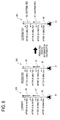
- FIG. 6 is a view that shows an example of the predicted traffic information generated by the current traffic information and the predicted traffic information to be distributed to the navigation apparatus 2 in a case where the CPU 11 provided in the information distribution center 3 performs the distribution data extracting process 2.
- congested road information 57 and 58 indicating that the degree of congestion is congested, that is, indicating that the congestion is presence, are stored respectively.
- Each of the congested road information 57 and 58 includes the actual length of the congestion, the time required to drive through the congestion, the degree of congestion, the speed of the vehicles in the congestion, the traveling direction in the congested lane, the time at which the congestion is expected to be over, or the like.
- the congested road information 57 indicating that the degree of congestion is congested, that is, indicating that the congestion is presence
- no-congestion road information 60 indicating that the degree of congestion is no congestion in which the congestion is released, that is, indicating that the congestion is absent
- the CPU 11 stores the congested road information 57 indicating that the degree of congestion is congested to be stored in the predicted traffic information 16C, in the RAM 12 as the predicted traffic information 16C to be distributed to the navigation apparatus 2 (S312: YES through S313 through S315). Thereby, the congested road information 57 is distributed to the navigation apparatus 2.
- no-congestion road information 60 indicating that the congestion is released and is absence to be stored to the predicted traffic information 16C, is not stored in the current traffic information 16A. Accordingly, since the traffic condition differs between the current traffic information 16A and the predicted traffic information 16C, the CPU 11 stores the no-congestion road information 60 in the RAM 12 as the predicted traffic information 16C to be distributed to the navigation apparatus 2, together with the link ID of the link corresponding to the no-congestion road information 60 (S314: YES through S313 through S315).
- the CPU 11 distributes the congested road information 57 indicating that the degree of congestion is congested and the no-congestion information 60 stored in the RAM 12, and the link ID of each link corresponding to the congested road information 57 and the no-congestion road information 60 to the navigation apparatus 2 as the predicted traffic information 16C (S115).
- the CPU 41 of the navigation apparatus 2 stores the congested road information 57, the no-congestion road information 60 and the link ID of each link corresponding to the congested road information 57 and the no-congestion road information 60 in the navigator-side traffic information DB 36 as the predicted traffic information 36C (S 13). Accordingly, it is possible for the CPU 41 to search the route based on the traffic information 36A, 36B, and 36C, without avoiding the location, which the vehicle arrives approximately after 45 minutes from the vehicle position of the road 55, as the location with no congestion.
- the route searching performed by the CPU 41 of the navigation apparatus 2 will be described below.
- the CPU 41 specifies the predicted traffic information 36C as the cost (weight), with respect to the road that the predicted traffic information 36C is presence. Also, the CPU 41 specifies the current traffic information 36A as the cost (weight), with respect to the road that the predicted traffic information 36C is absence. Further, the CPU 41 specifies the statistical traffic information 36B as the cost (weight), with respect to the road that the current traffic information 36A is also absence. Thus, the cost (weight) with respect to each road is specified, and searches a route of lowest cost (weight) to the destination, or a route avoiding the road of high cost (weight).
- the CPU 11 in a case where the CPU 11 provided in the information distribution center 3 receives the request command for requesting the predicted traffic information that has been transmitted from the navigation apparatus 2, as well as the vehicle information such as the navigator identifying ID, the coordinate data of the position of the vehicle, the coordinate data of the destination, the route search criterion, the version information of the navigation map information 37A, the CPU 11 searches the basic route based on the update-purpose map information 14A, and sets the distribution range that serves as a transmission target of the traffic information 16A, 16B and 16C (S111 through S 112).
- the CPU 11 generates the predicted traffic information 16C of the congestion prediction information or the like, based on the current traffic information 16A and the statistical traffic information 16B according to the distribution range (S113). Then, the CPU 11 extracts the predicted traffic information 16C of each link having a difference in the generated predicted traffic information 16C and the current traffic information 16A, and distributes the extracted predicted traffic information 16C to the navigation apparatus 2 together with the link ID of the corresponding links.
- the CPU 11 provided in the information distribution center 3 distributes the predicted traffic information 16C different from the current traffic information 16A within the distribution range to the navigation apparatus 2.
- the CPU 11 provided in the information distribution center 3 extracts all of the predicted traffic information 16C different from the current traffic information 16A with respect the each link, and distributes the information to the navigation apparatus 2.
- the CPU 41 of the navigation apparatus 2 to perform route searching with higher accuracy based on the accurate predicted traffic information 36C.
- the CPU 11 provided in the information distribution center 3 to accurately distribute the predicted no-congestion road information even when the amount of communication information distributed to the navigation apparatus 2 is reduced to keep the communication cost at a low level.
- the CPU 41 of the navigation apparatus 2 searches the route without missing any links included in the no-congestion road information.
Claims (3)
- Appareil de communication d'informations de trafic qui communique des informations de trafic, comprenant:une unité de réception d'informations de véhicule qui est apte à recevoir des informations de véhicule à partir d'un système de navigation (2) installé à bord d'un véhicule, les informations de véhicule comprenant au moins des données de coordonnées d'une position actuelle du véhicule,une unité d'obtention d'informations de trafic actuel qui est apte à obtenir des informations de trafic actuel (16A), les informations de trafic actuel (16A) étant associées à une liaison routière (55) et classées suivant un degré de congestion actuel de la liaison routière (55), dans lequel le degré de congestion actuel comprend au moins bondé ou encombré, ou ni bondé ni encombré,une unité de génération d'informations de trafic prédit qui est apte à générer des informations de trafic prédit (16C) selon un moment auquel le véhicule arrive à la liaison routière (55), sur la base des informations de véhicule, les informations de trafic prédit (16C) étant associées à la liaison routière (55) et classées suivant un degré de congestion prédit de la liaison routière (55), dans lequel le degré de congestion prédit comprend au moins bondé ou encombré, ou ni bondé ni encombré,une unité d'extraction d'informations de trafic prédit qui est apte à:extraire les informations de trafic prédit (16C) de la liaison routière (55) dans un cas dans lequel le degré de congestion prédit des informations de trafic prédit (16C) associées à la liaison routière (55) est soit encombré soit bondé,extraire les informations de trafic prédit (16C) de la liaison routière (55) dans un cas dans lequel le degré de congestion prédit des informations de trafic prédit (16C) associées à la liaison routière (55) n'est ni encombré ni bondé, et où le degré de congestion actuel des informations de trafic actuel (16A) associées à la liaison routière (55) est soit encombré soit bondé,ne pas extraire les informations de trafic prédit (16C) de la liaison routière (55) dans un cas dans lequel le degré de congestion prédit des informations de trafic prédit (16C) associées à la liaison routière (55) n'est ni encombré ni bondé, et où le degré de congestion actuel des informations de trafic actuel (16A) associées à la liaison routière (55) n'est ni encombré ni bondé, etune unité de commande de communication d'informations de trafic qui commande de telle sorte que les informations de trafic prédit (16C) extraites par l'unité d'extraction d'informations de trafic prédit soient communiquées au système de navigation (2).
- Appareil de communication d'informations de trafic selon la revendication 1, comprenant en outre une unité de réglage d'une portée de communication qui est apte régler une portée de communication servant de cible de transmission des informations de trafic basées sur les informations de véhicule, dans lequel l'unité de génération d'informations de trafic prédit est apte à générer les informations de trafic prédit (16C) selon la portée de communication.
- Procédé de communication d'informations de trafic pour communiquer des informations de trafic, comprenant les étapes suivantes:recevoir des informations de véhicule à partir d'un système de navigation (2) installé à bord d'un véhicule, les informations de véhicule comprenant au moins des données de coordonnées d'une position actuelle du véhicule,obtenir des informations de trafic actuel (16A), les informations de trafic actuel (16A) étant associées à une liaison routière (55) et classées suivant un degré de congestion actuel de la liaison routière (55), dans lequel le degré de congestion actuel comprend au moins bondé ou encombré, ou ni bondé ni encombré,générer des informations de trafic prédit (16C) selon un moment auquel le véhicule arrive à la liaison routière (55), sur la base des informations de véhicule, les informations de trafic prédit (16C) étant associées à la liaison routière (55) et classées suivant un degré de congestion prédit de la liaison routière (55), dans lequel le degré de congestion prédit comprend au moins bondé ou encombré, ou ni bondé ni encombré,extraire les informations de trafic prédit (16C) de la liaison routière (55) dans un cas dans lequel le degré de congestion prédit des informations de trafic prédit (16C) associées à la liaison routière (55) est soit encombré soit bondé,extraire les informations de trafic prédit (16C) de la liaison routière (55) dans un cas dans lequel le degré de congestion prédit des informations de trafic prédit (16C) associées à la liaison routière (55) n'est ni encombré ni bondé, et où le degré de congestion actuel des informations de trafic actuel (16A) associées à la liaison routière (55) est soit encombré soit bondé,ne pas extraire les informations de trafic prédit (16C) de la liaison routière (55) dans un cas dans lequel le degré de congestion prédit des informations de trafic prédit (16C) associées à la liaison routière (55) n'est ni encombré ni bondé, et où le degré de congestion actuel des informations de trafic actuel (16A) associées à la liaison routière (55) n'est ni encombré ni bondé, etcommander de telle sorte que les informations de trafic prédit (16C) extraites lors de l'étape d'extraction d'informations de trafic prédit soient communiquées au système de navigation (2).
Applications Claiming Priority (2)
| Application Number | Priority Date | Filing Date | Title |
|---|---|---|---|
| JP2006283523A JP4652307B2 (ja) | 2006-10-18 | 2006-10-18 | 交通情報配信装置 |
| PCT/JP2007/070498 WO2008050696A1 (fr) | 2006-10-18 | 2007-10-15 | Procédé et appareil de communication d'informations sur la circulation |
Publications (2)
| Publication Number | Publication Date |
|---|---|
| EP2062244A1 EP2062244A1 (fr) | 2009-05-27 |
| EP2062244B1 true EP2062244B1 (fr) | 2016-11-23 |
Family
ID=39081686
Family Applications (1)
| Application Number | Title | Priority Date | Filing Date |
|---|---|---|---|
| EP07830232.0A Expired - Fee Related EP2062244B1 (fr) | 2006-10-18 | 2007-10-15 | Procédé et appareil de communication d'informations sur la circulation |
Country Status (5)
| Country | Link |
|---|---|
| US (1) | US8103437B2 (fr) |
| EP (1) | EP2062244B1 (fr) |
| JP (1) | JP4652307B2 (fr) |
| CN (1) | CN101523460B (fr) |
| WO (1) | WO2008050696A1 (fr) |
Families Citing this family (24)
| Publication number | Priority date | Publication date | Assignee | Title |
|---|---|---|---|---|
| JP4730165B2 (ja) * | 2006-03-27 | 2011-07-20 | 株式会社デンソー | 交通情報管理システム |
| US9200913B2 (en) * | 2008-10-07 | 2015-12-01 | Telecommunication Systems, Inc. | User interface for predictive traffic |
| JP2010287206A (ja) * | 2009-05-15 | 2010-12-24 | Sumitomo Electric Ind Ltd | 交通情報推定装置、交通情報推定のためのコンピュータプログラム、及び交通情報推定方法 |
| DE112010004633T5 (de) | 2009-12-01 | 2012-11-29 | Mitsubishi Electric Corporation | Fahrzeugmontierte Bildverarbeitungsvorrichtung und Reisehilfevorrichtung |
| JP5083345B2 (ja) * | 2010-03-03 | 2012-11-28 | 住友電気工業株式会社 | 交通情報予測装置、交通情報予測のためのコンピュータプログラム、及び交通情報予測方法 |
| GB201113122D0 (en) | 2011-02-03 | 2011-09-14 | Tom Tom Dev Germany Gmbh | Generating segment data |
| CN102682616B (zh) * | 2011-03-16 | 2016-03-16 | 高德软件有限公司 | 无线数据广播系统交通信息发布方法和设备 |
| US8990005B2 (en) * | 2011-04-22 | 2015-03-24 | Bayerische Motoren Werke Aktiengesellschaft | System and method for providing georeferenced predictive information to motor vehicles |
| US9518830B1 (en) | 2011-12-28 | 2016-12-13 | Intelligent Technologies International, Inc. | Vehicular navigation system updating based on object presence |
| JP5648009B2 (ja) * | 2012-03-21 | 2015-01-07 | アイシン・エィ・ダブリュ株式会社 | 交通情報作成装置、交通情報作成方法及びプログラム |
| WO2014013542A1 (fr) * | 2012-07-17 | 2014-01-23 | 三菱電機株式会社 | Dispositif de notification d'information de trafic dans un véhicule |
| US9368027B2 (en) * | 2013-11-01 | 2016-06-14 | Here Global B.V. | Traffic data simulator |
| US9495868B2 (en) | 2013-11-01 | 2016-11-15 | Here Global B.V. | Traffic data simulator |
| JP6387636B2 (ja) * | 2014-03-18 | 2018-09-12 | 富士通株式会社 | 抽出方法、推奨方法、情報処理装置及び道路補修工法決定支援プログラム |
| CN103927873B (zh) * | 2014-04-28 | 2016-06-15 | 中国航天系统工程有限公司 | 浮动车与路段匹配方法及并行获取实时路况的方法 |
| US9945689B2 (en) | 2015-08-25 | 2018-04-17 | Here Global B.V. | Location referencing for roadway feature data |
| DE102016213013A1 (de) * | 2016-07-15 | 2018-01-18 | Robert Bosch Gmbh | Verfahren und Vorrichtung zum Steuern eines Verkehrs zum Reduzieren einer Luftverschmutzung |
| JP6909017B2 (ja) * | 2017-02-23 | 2021-07-28 | 株式会社Nttドコモ | 情報配信システム |
| JP6909048B2 (ja) * | 2017-05-17 | 2021-07-28 | 本田技研工業株式会社 | 情報処理サーバ |
| KR101935528B1 (ko) * | 2017-11-28 | 2019-01-04 | 서강대학교 산학협력단 | 차분 프라이버시를 적용한 교통량 배포 시스템 및 방법 |
| KR20200067055A (ko) * | 2018-12-03 | 2020-06-11 | 현대자동차주식회사 | 교통정보 제공 장치 및 방법 |
| JP7318576B2 (ja) * | 2020-03-18 | 2023-08-01 | トヨタ自動車株式会社 | 情報処理装置、情報処理システム、プログラム、及び車両 |
| JP2021189770A (ja) * | 2020-05-29 | 2021-12-13 | トヨタ自動車株式会社 | 情報処理装置、情報処理システム、プログラム、及び車両 |
| CN114005282B (zh) * | 2021-12-30 | 2022-03-29 | 南京城建隧桥智慧管理有限公司 | 一种基于群智感知的智慧城市交通管理系统及方法 |
Family Cites Families (19)
| Publication number | Priority date | Publication date | Assignee | Title |
|---|---|---|---|---|
| DE19629233C2 (de) * | 1996-07-22 | 2003-08-07 | T Mobile Deutschland Gmbh | Verfahren zur Auswahl und Filterung von Verkehrsinformationen |
| DE19651143B4 (de) | 1996-12-10 | 2013-07-25 | T-Mobile Deutschland Gmbh | Verfahren und Anordnung zur Verkehrsinformation |
| EP0958565B1 (fr) | 1997-02-06 | 2004-06-16 | ATX Europe GmbH | Transmission d'informations routieres regionales |
| DE19843203A1 (de) * | 1998-09-14 | 2000-03-16 | Mannesmann Ag | Verfahren zur benutzerindividuellen Auswahl und Sendung von Verkehrsinformationen von einer Verkehrszentrale an einen Benutzer und Verkehrsinformationszentrale |
| DE19856704C2 (de) * | 1998-12-09 | 2001-09-13 | Daimler Chrysler Ag | Verfahren und Vorrichtung zur Fahrzeugzielführung und/oder Reisezeitschätzung |
| JP2003151079A (ja) * | 2001-11-19 | 2003-05-23 | Alpine Electronics Inc | 交通情報提供システム |
| JP2003194557A (ja) * | 2001-12-27 | 2003-07-09 | Toyota Motor Corp | 交通情報出力装置及び交通情報配信装置並びに配信方法 |
| JP2003302229A (ja) | 2002-04-08 | 2003-10-24 | Hitachi Ltd | ナビゲーション装置 |
| JP2005127887A (ja) * | 2003-10-24 | 2005-05-19 | Alpine Electronics Inc | 車載用ナビゲーション装置及び道路交通情報提供方法 |
| JP4561139B2 (ja) * | 2004-03-22 | 2010-10-13 | アイシン・エィ・ダブリュ株式会社 | ナビゲーションシステム |
| JP2005331414A (ja) * | 2004-05-20 | 2005-12-02 | Clarion Co Ltd | ナビゲーション装置、ナビゲーション方法及びナビゲーションプログラム |
| JP4479379B2 (ja) | 2004-06-30 | 2010-06-09 | アイシン・エィ・ダブリュ株式会社 | ナビゲーション装置 |
| JP4419721B2 (ja) | 2004-07-02 | 2010-02-24 | アイシン・エィ・ダブリュ株式会社 | ナビゲーションシステム |
| JP4822680B2 (ja) * | 2004-08-10 | 2011-11-24 | 株式会社東芝 | 磁気抵抗効果素子の製造方法 |
| JP2006078405A (ja) * | 2004-09-10 | 2006-03-23 | Aisin Aw Co Ltd | ナビゲーション装置、ナビゲーションシステム |
| JP4691936B2 (ja) | 2004-09-24 | 2011-06-01 | アイシン・エィ・ダブリュ株式会社 | 情報表示システム |
| US7363144B2 (en) * | 2005-02-07 | 2008-04-22 | International Business Machines Corporation | Method and apparatus for predicting future travel times over a transportation network |
| JP4501718B2 (ja) * | 2005-02-18 | 2010-07-14 | 日産自動車株式会社 | 車両用情報取得装置、車両用情報配信システムおよび車両用情報取得方法 |
| US7908076B2 (en) * | 2006-08-18 | 2011-03-15 | Inrix, Inc. | Representative road traffic flow information based on historical data |
-
2006
- 2006-10-18 JP JP2006283523A patent/JP4652307B2/ja active Active
-
2007
- 2007-10-15 US US12/442,280 patent/US8103437B2/en active Active
- 2007-10-15 WO PCT/JP2007/070498 patent/WO2008050696A1/fr active Application Filing
- 2007-10-15 CN CN200780038395.2A patent/CN101523460B/zh not_active Expired - Fee Related
- 2007-10-15 EP EP07830232.0A patent/EP2062244B1/fr not_active Expired - Fee Related
Also Published As
| Publication number | Publication date |
|---|---|
| US8103437B2 (en) | 2012-01-24 |
| EP2062244A1 (fr) | 2009-05-27 |
| CN101523460A (zh) | 2009-09-02 |
| JP2008102664A (ja) | 2008-05-01 |
| JP4652307B2 (ja) | 2011-03-16 |
| WO2008050696A1 (fr) | 2008-05-02 |
| US20090248286A1 (en) | 2009-10-01 |
| CN101523460B (zh) | 2012-06-27 |
Similar Documents
| Publication | Publication Date | Title |
|---|---|---|
| EP2062244B1 (fr) | Procédé et appareil de communication d'informations sur la circulation | |
| US8209114B2 (en) | Traffic information generating apparatus and traffic information generating method | |
| US8150612B2 (en) | Traffic information distributing apparatus | |
| US7925425B2 (en) | Navigation information distribution systems, methods, and programs | |
| JP4840069B2 (ja) | ナビゲーションシステム | |
| EP1870671B1 (fr) | Système de fourniture d'informations cartographiques | |
| KR101087432B1 (ko) | 지도 갱신 배포 및 알림 시스템 | |
| EP1906375A2 (fr) | Dispositif de navigation pour recevoir des informations routières | |
| EP1965171A2 (fr) | Système de mise à jour d'informations cartographiques | |
| JP4811063B2 (ja) | 交通データ算出システム | |
| EP1801764B1 (fr) | Appareil de navigation | |
| EP2104018A2 (fr) | Système de création de base de données et procédé de création de base de données | |
| JP2008210123A (ja) | 渋滞情報作成装置 | |
| JP2012047759A (ja) | 交通情報配信装置 |
Legal Events
| Date | Code | Title | Description |
|---|---|---|---|
| PUAI | Public reference made under article 153(3) epc to a published international application that has entered the european phase |
Free format text: ORIGINAL CODE: 0009012 |
|
| 17P | Request for examination filed |
Effective date: 20090320 |
|
| AK | Designated contracting states |
Kind code of ref document: A1 Designated state(s): AT BE BG CH CY CZ DE DK EE ES FI FR GB GR HU IE IS IT LI LT LU LV MC MT NL PL PT RO SE SI SK TR |
|
| AX | Request for extension of the european patent |
Extension state: AL BA HR MK RS |
|
| RBV | Designated contracting states (corrected) |
Designated state(s): DE FR GB |
|
| RBV | Designated contracting states (corrected) |
Designated state(s): DE FR GB |
|
| 17Q | First examination report despatched |
Effective date: 20100726 |
|
| DAX | Request for extension of the european patent (deleted) | ||
| RAP1 | Party data changed (applicant data changed or rights of an application transferred) |
Owner name: TOYOTA JIDOSHA KABUSHIKI KAISHA Owner name: AISIN AW CO., LTD. |
|
| GRAP | Despatch of communication of intention to grant a patent |
Free format text: ORIGINAL CODE: EPIDOSNIGR1 |
|
| INTG | Intention to grant announced |
Effective date: 20160712 |
|
| GRAS | Grant fee paid |
Free format text: ORIGINAL CODE: EPIDOSNIGR3 |
|
| GRAA | (expected) grant |
Free format text: ORIGINAL CODE: 0009210 |
|
| AK | Designated contracting states |
Kind code of ref document: B1 Designated state(s): DE FR GB |
|
| REG | Reference to a national code |
Ref country code: GB Ref legal event code: FG4D |
|
| REG | Reference to a national code |
Ref country code: DE Ref legal event code: R096 Ref document number: 602007048903 Country of ref document: DE |
|
| REG | Reference to a national code |
Ref country code: DE Ref legal event code: R097 Ref document number: 602007048903 Country of ref document: DE |
|
| REG | Reference to a national code |
Ref country code: FR Ref legal event code: PLFP Year of fee payment: 11 |
|
| PLBE | No opposition filed within time limit |
Free format text: ORIGINAL CODE: 0009261 |
|
| STAA | Information on the status of an ep patent application or granted ep patent |
Free format text: STATUS: NO OPPOSITION FILED WITHIN TIME LIMIT |
|
| 26N | No opposition filed |
Effective date: 20170824 |
|
| REG | Reference to a national code |
Ref country code: FR Ref legal event code: PLFP Year of fee payment: 12 |
|
| PGFP | Annual fee paid to national office [announced via postgrant information from national office to epo] |
Ref country code: FR Payment date: 20190913 Year of fee payment: 13 |
|
| PGFP | Annual fee paid to national office [announced via postgrant information from national office to epo] |
Ref country code: DE Payment date: 20191001 Year of fee payment: 13 |
|
| PGFP | Annual fee paid to national office [announced via postgrant information from national office to epo] |
Ref country code: GB Payment date: 20191011 Year of fee payment: 13 |
|
| REG | Reference to a national code |
Ref country code: DE Ref legal event code: R119 Ref document number: 602007048903 Country of ref document: DE |
|
| GBPC | Gb: european patent ceased through non-payment of renewal fee |
Effective date: 20201015 |
|
| PG25 | Lapsed in a contracting state [announced via postgrant information from national office to epo] |
Ref country code: FR Free format text: LAPSE BECAUSE OF NON-PAYMENT OF DUE FEES Effective date: 20201031 Ref country code: DE Free format text: LAPSE BECAUSE OF NON-PAYMENT OF DUE FEES Effective date: 20210501 |
|
| PG25 | Lapsed in a contracting state [announced via postgrant information from national office to epo] |
Ref country code: GB Free format text: LAPSE BECAUSE OF NON-PAYMENT OF DUE FEES Effective date: 20201015 |