EP1530025A2 - Système de navigation adaptatif utilisant de l'intelligence artificielle - Google Patents
Système de navigation adaptatif utilisant de l'intelligence artificielle Download PDFInfo
- Publication number
- EP1530025A2 EP1530025A2 EP04022557A EP04022557A EP1530025A2 EP 1530025 A2 EP1530025 A2 EP 1530025A2 EP 04022557 A EP04022557 A EP 04022557A EP 04022557 A EP04022557 A EP 04022557A EP 1530025 A2 EP1530025 A2 EP 1530025A2
- Authority
- EP
- European Patent Office
- Prior art keywords
- vehicle
- route
- road segment
- navigation system
- digital map
- Prior art date
- Legal status (The legal status is an assumption and is not a legal conclusion. Google has not performed a legal analysis and makes no representation as to the accuracy of the status listed.)
- Granted
Links
Images


Classifications
-
- G—PHYSICS
- G01—MEASURING; TESTING
- G01C—MEASURING DISTANCES, LEVELS OR BEARINGS; SURVEYING; NAVIGATION; GYROSCOPIC INSTRUMENTS; PHOTOGRAMMETRY OR VIDEOGRAMMETRY
- G01C21/00—Navigation; Navigational instruments not provided for in groups G01C1/00 - G01C19/00
- G01C21/26—Navigation; Navigational instruments not provided for in groups G01C1/00 - G01C19/00 specially adapted for navigation in a road network
- G01C21/34—Route searching; Route guidance
- G01C21/3453—Special cost functions, i.e. other than distance or default speed limit of road segments
- G01C21/3484—Personalized, e.g. from learned user behaviour or user-defined profiles
-
- G—PHYSICS
- G01—MEASURING; TESTING
- G01C—MEASURING DISTANCES, LEVELS OR BEARINGS; SURVEYING; NAVIGATION; GYROSCOPIC INSTRUMENTS; PHOTOGRAMMETRY OR VIDEOGRAMMETRY
- G01C21/00—Navigation; Navigational instruments not provided for in groups G01C1/00 - G01C19/00
- G01C21/38—Electronic maps specially adapted for navigation; Updating thereof
- G01C21/3804—Creation or updating of map data
- G01C21/3807—Creation or updating of map data characterised by the type of data
- G01C21/3815—Road data
-
- G—PHYSICS
- G01—MEASURING; TESTING
- G01C—MEASURING DISTANCES, LEVELS OR BEARINGS; SURVEYING; NAVIGATION; GYROSCOPIC INSTRUMENTS; PHOTOGRAMMETRY OR VIDEOGRAMMETRY
- G01C21/00—Navigation; Navigational instruments not provided for in groups G01C1/00 - G01C19/00
- G01C21/38—Electronic maps specially adapted for navigation; Updating thereof
- G01C21/3804—Creation or updating of map data
- G01C21/3833—Creation or updating of map data characterised by the source of data
- G01C21/3837—Data obtained from a single source
-
- G—PHYSICS
- G01—MEASURING; TESTING
- G01C—MEASURING DISTANCES, LEVELS OR BEARINGS; SURVEYING; NAVIGATION; GYROSCOPIC INSTRUMENTS; PHOTOGRAMMETRY OR VIDEOGRAMMETRY
- G01C21/00—Navigation; Navigational instruments not provided for in groups G01C1/00 - G01C19/00
- G01C21/38—Electronic maps specially adapted for navigation; Updating thereof
- G01C21/3804—Creation or updating of map data
- G01C21/3833—Creation or updating of map data characterised by the source of data
- G01C21/3844—Data obtained from position sensors only, e.g. from inertial navigation
Definitions
- This invention relates generally to vehicle navigation systems and, more particularly, to an adaptive navigation system that is capable of taking into account and learning driver habits, mistakes in the digital map database and new roads that are constructed after the digital map database has been released.
- a typical vehicle navigation system may include a global positioning system (“GPS") receiver that may be mounted somewhere on the vehicle.
- GPS global positioning system
- the GPS receiver is capable of communicating with a satellite-based global positioning system or other localized positioning systems.
- the GPS receiver obtains geographic position information that may be converted into some form of display for the vehicle operator indicating the position of the vehicle relative to previously determined reference points or other known landmarks in a given map database.
- Other systems and devices may also be used to determine the geographic position of the vehicle as well.
- the typical vehicle navigation system may also include a digital map database that includes digitized map information that can be processed by a navigation computer designed to handle map-related functions.
- the map information may be related to roads and various types of road data as well as waterway data.
- a map-matching module or software routine may be used to match the position or trajectory measured by a positioning module to a position associated with a location or route on a map provided from the digital map database.
- the positioning module may receive its information from the GPS receiver.
- the typical vehicle navigation system may also include a human-machine interface module that provides users with a way to interact with the navigation system.
- a visual display is typically used to convert signals into a visual image in real time for direct interpretation by the user. As such, displays are used to provide optical driver recommendations, which are usually conveyed by a digital map generated on the display.
- the display itself is typically an electro-optical device such as a liquid crystal display (“LCD”), a cathode-ray tube (“CRT”) display, an electroluminescent display (“ELD”), a heads-up display (“HUD”), a plasma display panel (“PDP”), a vacuum fluorescent display (“VFD”), or a touch-screen display.
- LCD liquid crystal display
- CRT cathode-ray tube
- ELD electroluminescent display
- HUD heads-up display
- PDP plasma display panel
- VFD vacuum fluorescent display
- a route calculation module may also be included that is used to plan a route prior to or during a trip.
- One commonly used technique is to find a minimum-travel-cost route, which is designed to minimize the amount of distance traveled and the costs associated with reaching a predetermined destination.
- a route guidance module may also be included that is used to guide the driver along the route generated by the route planning module. The real time or en-route guidance is typically generated using optical driver recommendations on the display and may also include acoustic driver recommendations.
- current navigation radio products determine a route based on 1) a fixed map database that may reside in a media such as a compact-disc (“CD”), a digital-video disc (“DVD”) or hard drive and 2) a fixed algorithm such as Djikstra's shortest route algorithm. Given the same starting conditions and the same destination, the navigation radio should provide identical results each time.
- a fixed map database that may reside in a media such as a compact-disc (“CD”), a digital-video disc (“DVD”) or hard drive
- a fixed algorithm such as Djikstra's shortest route algorithm
- TMC integrated dynamic navigation
- traffic information is provided on a data channel through an FM radio station thereby allowing the navigation radio to dynamically adapt a given route based on traffic conditions.
- Navigation system algorithms do not take into account driver habits, mistakes in the database and new roads that are constructed after the map data in the database was released into fixed media. As such, this limits the functionality of the navigation radio and causes the user to pay significant fees to update the fixed map database. It also frustrates the driver when the navigation system disregards driver preferences and contradicts the route a driver takes, for example from home to work. In some locations, such as the United States, the driver of the vehicle may also not have the advantage of TMC to provide updates about congested roads and automatically reroute a vehicle to avoid the congested roads. In the absence of such data, it would be advantageous to provide a means of avoiding roads that are regularly congested at certain times of the day.
- This invention discloses a vehicle navigation system that incorporates the use of artificial intelligence so that the vehicle navigation system learns as a driver operates the vehicle.
- the vehicle navigation system takes into account driver habits and preferences, mistakes in the digital map database and new roads that may have been constructed after the digital map database has been released.
- the driver habits or preferences may be stored in a database in a storage device and may be used by the vehicle navigation system to automatically guide the driver to learned destinations based on driver habits. If a mistake exists in the digital map database, the vehicle navigation system can correct the mistake and store the updated information in the database or an update file. Further, the vehicle navigation system may be provided with the ability to learn new roads that may have been constructed or missed when the map database was released for use by the vehicle navigation system.
- the vehicle navigation system may include a navigation control unit that may be connected with a display, a user input device, a digital map database, a positioning system, a storage device and a traffic event notification device.
- the display may be used to generate a graphical representation of a road network map included in the digital map database that may be used to guide the driver along a route to a predetermined destination.
- the display may be used as an input device if the display comprises a touch-screen display.
- the user input device may be used by the driver to enter information about the trip destination as well as other travel options or restrictions as desired by the driver of the vehicle.
- An artificial intelligence (“AI”) module may be included in the vehicle navigation system that is connected with or associated with the positioning system, a map-matching module, a route calculation module, a user interface module, a route guidance module, and the digital map database.
- the AI module may be capable of learning habits or preferences that the driver prefers instead of always choosing a route for the driver. Mistakes in the digital map database may also be learned by the AI module and corrected in the digital map database.
- the AI module may also be capable of mapping out and storing new roads or road segments in the digital map database.
- the navigation system 100 includes a navigation control unit 102 that processes software modules and components that are programmed to calculate routes from points of origin to destinations as well as provide various other types of data to a driver.
- the navigation control unit 102 may include a Central Processing Unit (“CPU”), a system bus, a Random Access Memory (“RAM”), a Read Only Memory (“ROM”), an I/O adapter for connecting peripheral devices such as hard disc drives, CD drives, a communications adapter, and a display adapter.
- CPU Central Processing Unit
- RAM Random Access Memory
- ROM Read Only Memory
- I/O adapter for connecting peripheral devices such as hard disc drives, CD drives
- a communications adapter such as hard disc drives, CD drives
- a display adapter such as a Wi-Fi adapter
- Various computing devices and components may be used to provide the functionality performed by the navigation control unit 102.
- the navigation control unit 102 may be connected with a display 104.
- the display 104 may be a touch-screen display that functions as both a display and a user input device.
- the navigation control unit 102 may be connected with a user input device 106.
- the user input device 106 may be a keypad, a personal computer, a laptop computer, a pocket PC, a personal digital assistant, a wireless access device or phone, or any other type of device that is capable of allowing a user of the navigation system 100 to input data during operation.
- both the navigation control unit 102 and the user input device 106 may be connected with a wireless communication device that is capable of passing the necessary data back and forth between the user input device 106 and the navigation control unit 102.
- Some illustrative methods of connecting the user input device 106 with the navigation control unit 102 that may be used include infrared, Bluetooth, wireless LAN, Universal Serial Bus, fiber optic, direct wire, parallel ports, serial ports, and a network connection in series.
- the navigation control unit 102 may be connected to a digital map database 108.
- the digital map database 108 may be located on a hard disc storage device, a CD, a DVD or any other suitable storage medium.
- the digital map database 108 contains a digital map of road networks for various geographic locations as well as other types of data.
- the digital map database 108 allows the navigation control unit 102 to display a map of a geographic location including road networks and can help locate an address or destination using a street address or nearby intersections.
- the digital map database 108 can help calculate a travel route, can match sensor-detected vehicle trajectory with a known road network to determine more accurately the actual position of the vehicle in relation to the map; or provide travel information such as road classification data, travel guides, landmarks, hotel information, restaurant information and so forth.
- the navigation control unit 102 may also be connected to at least one positioning system 110.
- the positioning system 110 may be used to determine the geographic location or coordinates of a vehicle in which the navigation system 100 is installed.
- the positioning system 110 may be capable of determining the trajectory or direction of movement of the vehicle. Positioning involves the determination of the geo-coordinates of the vehicle on the surface of the Earth. Knowing the position and trajectory of the vehicle allows the navigation control unit 102 to determine the position of the vehicle relative to a road network map and the direction of travel.
- the navigation control unit 102 is also able to provide maneuvering instructions to the driver of the vehicle by knowing the geographic location and trajectory of the vehicle.
- a dead reckoning system is an illustrative stand-alone system that may be used by the navigation system 100.
- a satellite-based system that may be used involves equipping the vehicle with a global positioning system ("GPS") receiver or any other type of system that uses satellites to determine geographic locations.
- GPS global positioning system
- a terrestrial radio based system is a system that uses measurement techniques to determine the location of the vehicle.
- TOA time of arrival
- AOA angle of arrival
- TDOA time difference of arrival
- a wireless access device 112 may be connected with the navigation control unit 102.
- the wireless access device 112 may connect the navigation control unit 102 to a navigation server 114.
- the navigation control unit 102 may log into the navigation server 114 using the wireless access device 112 and each respective device may then be able to exchange data back and forth.
- a wireless data transmission protocol (such as WAP) may be used to transmit data and route planning information generated by the navigation server 114 or the navigation control unit 102 to and/or from each respective device.
- the navigation server 114 may also be connected with or associated with the map database 108.
- the navigation control unit 102 may also be connected with a memory storage device 116.
- the memory storage device 116 may be used to store various types of data that is used by the navigation system 100. Trip origins and trip destinations may be stored in the memory storage device 116. In addition, routes to various destinations may be stored in the memory storage device 116. As set forth in detail below, learned driver habits and/or preferences, new roads and mistakes in the digital map database 108 may also be stored in the memory storage device 116. Data may also be stored in the navigation server 114 as well as the navigation system 100. Data may then be transferred to the navigation control unit 102 using the wireless access device 112 if data is stored in the navigation server 114.
- the navigation system 100 may also include a traffic event notification device 118 that is capable of receiving incoming notifications of traffic events.
- the traffic event notification device 118 may be connected with the navigation control unit 102.
- the navigation control unit 102 may use signals received from the traffic event notification device 118 to dynamically route a vehicle in which the navigation system 100 is installed around traffic obstacles or events that may be in front of the path of the driver.
- traffic event notification devices 118 may be used by the navigation system 100.
- the example navigation system 100 is illustrated as including a plurality of code segments, software routines, or software modules that use the digital map database 108 to plan routes and guide the driver to destinations.
- the digital map database 108 contains map information in a predefined format that is capable of being read and used by the navigation control unit 102 or the navigation server 114 illustrated in Figure 1.
- the navigation control unit 102 may use the map information for map related functions such as identifying and providing locations, address information, road classifications, road restrictions, road names, traffic regulations, travel information and so forth.
- the digital map database 108 may also contain a detailed road network map of various geographic locations.
- the road network map may include nodes and segments that make up roads that are used by vehicles to travel to predetermined destinations. Nodes as the term is used herein may be defined as locations that road intersections exist or where exits or entrances from roads exist and segments may be defined as sections of roads that exist between respective nodes.
- a positioning module 200 may be included that determines the geographic location and trajectory of the vehicle using input signals from the positioning system 110. As set forth above, several different positioning systems 110 may be used to determine the trajectory and geographic position of the vehicle.
- the positioning module 200 may include an integration algorithm that uses signals generated by the positioning system 110 to determine the precise geographic location and trajectory of the vehicle.
- a map-matching module 202 may be used to match the geographic location of the vehicle with a position on the road network map generated from the digital map database 108.
- a map-matching algorithm of the map-matching module 202 may be used to place the vehicle in the proper location on the road network map.
- the map-matching module 202 is capable of correlating the vehicle position and trajectory from the positioning module 200 to the road network map by comparing the vehicle trajectory and location with the map data present in the digital map database 108.
- the navigation control unit 102 may also include a route calculation module 204.
- Route calculation is the process of planning a route prior to or during a trip to a predetermined destination.
- the route calculation module 204 may use a shortest path algorithm, such as Djistra's shortest route algorithm, to determine a recommended route from a trip origin to a trip destination.
- shortest path algorithms such as Djistra's shortest route algorithm
- Different shortest path algorithms and variations of shortest path algorithms may be used in the navigation system 100 as well as other types of algorithms.
- the route calculation module 204 may also include a route optimization module that uses planning criteria to plan the route.
- the quality of any given route may depend on many factors and selection criteria such as distance, road types, speed limits, location, number of stops, number of turns and traffic information.
- the route selection criteria can either be fixed at manufacture or may be implemented through a user interface module 206. Determination of the best route uses the selection criteria and a digital road network map retrieved from the digital map database 108 to minimize distance and travel time.
- the navigation system 100 may also allow drivers to compute routes interactively by opening or closing nodes or segments in the road network map.
- the navigation control unit 102 may also include the user interface module 206.
- the user interface module 206 may generate a graphical user interface ("GUI") on the display 104.
- GUI graphical user interface
- the user interface module 206 may also allow a user of the navigation system 100 to interact with the navigation system 100 and enter inputs into the navigation system 100.
- the user interface module 206 may receive inputs from the display 104 if it is a touch-screen display.
- the user input device 106 may also be used to enter inputs into the user interface module 206.
- the user inputs may be provided to the route calculation module 204, which may then calculate a route to the destination that is input by the driver.
- the navigation control unit 102 may also include a route guidance module 208.
- the route guidance module 208 may guide the driver along the route generated by the route calculation module 204.
- the route guidance module 208 may use the positioning module 200, the digital map database 108 and the map-matching module 202 to guide the driver along the route to their respective destination.
- the guidance may be provided to the driver in a graphic format or as acoustical driver recommendations.
- the route guidance module 208 may also allow the user interface module 206 to generate a road network map GUI on the display 104 that illustrates where the vehicle is located on the road network map and the direction the vehicle is traveling and needs to travel.
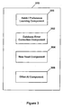
- the navigation control unit 102 may also include an artificial intelligence (AI) module 210.
- AI artificial intelligence
- One function of the AI module 210 is to monitor driver habits or preferences so that the navigation system 100 is more in tune with what routes particular drivers desire when traveling to certain destinations.
- the AI module 210 is capable of correcting mistakes in the digital map database 108.
- Road data contained in the digital map database 108 may contain errors that confuse the driver or the navigation system 100.
- the AI module 210 may also be capable of adding new roads to the digital map database 108 that were either not entered when the digital map database 108 was created or have been newly constructed after the digital map database 108 was released and distributed for use.
- example components of the AI module 210 are set forth and may include a habit/preference learning component 300, a database error correction component 302, a new road learning component 304 and other types of AI learning components 306.
- Other types of AI learning components 306 may be implemented to allow the navigation system 100 to learn new restaurants, shopping centers, landmarks, and so forth.
- the AI module 210 allows the navigation system 100 to learn a particular driver's preferences as well as obtain and record new updated information related to data contained in the digital map database 108.
- the habit/preference learning component 300 is responsible for monitoring and learning a particular driver's habits and/or preferences.
- the database error correction component 302 monitors and detects variations and errors in the data contained in the digital map database 108 and may update the navigation system 100 with correct information.
- the new road component 304 may detect new roads and add the geographic coordinates of the new roads to the digital map database 108 or the memory storage device 116 for later use by the navigation system 100.
- the new road component 304 may also allow the driver to input data about the new road such as speed limits and road names.
- the habit/preference learning component 300 may be programmed to monitor the daily habits or preferences of a particular driver. On a frequently traveled route, the habit/preference learning component 300 may automatically recommend a driver preferred route to a respective destination instead of the route that may be calculated by the route calculation module 204. As such, the habit/preference learning component 300 may override the route that may be calculated by the route calculation module 204 in favor of the driver preferred route that the driver takes out of habit or out of personal preference.
- a driver normally takes a preferred route to work that deviates from the route that is calculated by the route calculation module 204 using the shortest route algorithm.
- the driver usually leaves for work between the hours of 7:15 a.m. and 7:45 a.m. on Monday-Friday.
- the habit/preference learning component 300 may update the route calculation module 204 to automatically select and use the preferred route of the driver instead of the route that would normally be calculated by the route calculation module 204.
- the habit/preference learning component 300 may also store the preferred route in the memory storage device 116 of the navigation system 100.
- the navigation system 100 knows to use the preferred route of the driver instead of the route calculated by the route calculation module 204 because the AI module 210 has learned the driver habit or preference to reach that particular destination.
- Several different scenarios may exist depending upon the origin of the trip and the destination.
- a preferred route to a shopping center may be used over the shortest route calculated by the route calculation module 204 because a respective driver simply prefers to take that route to the shopping center.
- Figure 4 is a flow chart of some of the example tasks that may be performed by the habit/preference learning component 300 discussed with reference to Figures 1-4.
- the driver of the vehicle may enter a destination and the route calculation module 204 may calculate a route to that destination, which is typically based on some form of the shortest path algorithm.
- the habit/preference module 300 may monitor or track each destination that is input by a respective driver, which is represented at step 402.
- the habit/preference component 300 may record the trip origin, the trip destination, the time of day, the day of the week, the driver and so forth.
- the habit/preference module 300 may determine if the destination input by the driver is a destination that the driver has input in the past or traveled to several times. If the destination is not a prior destination, meaning it is a new destination, the habit/preference module 300 may add the destination and its associated data (origin, time, day, etc.) to a destination data file that may be stored in the memory storage device 116, which is represented at step 406. If the destination is a destination traveled to at a prior time by the driver, the destination data file in the database may be updated with corresponding data about the current trip at step 408. A counter in a database that is associated with the destination may be updated to reflect another trip to that particular destination by that driver.
- the habit/preference module 300 may track the actual route that is taken to the destination by the driver, which is represented at step 410.
- the actual route taken may be stored in the memory storage device 116 of the navigation system 100. Deviations from the route calculated by the route calculation module 204 may be recorded and stored or the entire route taken by the driver may be stored in the memory storage device 116. As such, a preferred route of the driver to the destination may be stored in the memory storage device 116, which may deviate from the route that is calculated by the route calculation module 204.
- the habit/preference learning module 300 may determine if the number of times the driver has traveled to that particular destination using the preferred route exceeds a certain threshold value. If the number of times exceeds the threshold value, the AI module 210 may add the preferred route to a preferred route list that may be stored in the digital map database 108 or the memory storage device 116, which is illustrated at step 414. The AI module 210 may inform or program the route calculation module 204 to automatically select and use the preferred route of the driver and not the route calculated using the shortest path algorithm of the route calculation module 204 the next time the driver is traveling to that particular destination, which is represented at step 416. As set forth above, a database may contain a list of preferred routes that is searched before the route calculation module 204 uses some form of the shortest path algorithm to calculate a route. As such, the preferred route of the driver may be used for all future trips to the destination.
- a particular driver of a vehicle drives to work every morning on Monday -Friday and normally leaves for work between 7:15 a.m. and 7:45 a.m.
- the driver has been using a preferred route for several years and does not desire to use the route that is calculated by the route calculation module 204.
- the driver may have several personal reasons for not using that route, but nonetheless, the navigation system 100 is capable of dynamically adapting and learning driving habits and/or preferences of the driver so that the preferred route of the driver is selected and not the route that may be calculated by the route calculation module 204.
- the AI module 210 sets the calculated route to that particular destination to the preferred route used by the driver. The number of times the driver must deviate from the calculated route may vary.
- the AI module 210 may also be operable to generate a graphical user interface that prompts the user to inform the navigation system 100 if the route taken by the driver that deviates from the calculated route should be used as the preferred route. As set forth above, the AI module 210 is able to learn driver habits and exploit them for the benefit of the driver.
- the navigation control unit 102 and the navigation server 114 may exchange data relating to the driver's preference.
- the navigation server 114 may then store the preferred route in a database file associated with the driver's account on or associated with the navigation server 114.
- Several of the software modules and components set forth above may reside in various hardware locations and may include applications installed on each device that allows the transfer of data to and from each respective device.
- the habit/preference learning module 300 may also be operable to learn roads that are congested during particular times of day.
- the navigation system 100 may guide the driver along alternative routes that avoid roads that are congested during particular time periods or days of the week.
- the habit/preference learning module 300 may learn roads that are congested at particular times by monitoring the rate of speed along a given road segment over a period of time. For example, if the driver is traveling along a route that contains a congested road two days in a row, on the third day the navigation system 100 may calculate a route that avoids the congested area automatically without interaction from the driver.
- the AI module 300 has learned to avoid that particular road segment because of the congestion and recommends a route that avoids that particular road segment.
- the database error correction component 302 may be used to track mistakes that occur or are present in the digital map database 108 and take corrective action when necessary.
- Digital map databases may be purchased from various third-party vendors.
- the database error correction component 302 is capable of correcting errors in the digital map database 108 located on either the vehicle navigation system 100 or the navigation server 114.
- the database error correction component 302 learns mistakes in the data contained in the digital map database 108 and corrects the data so that the digital map database 108 contains more accurate data.
- a third party owner of the data base could be alerted of potential changes in the digitized data base and the frequency that the users are experiencing these changes.
- an error may exist in the data that is contained in the digital map database 108.
- the geographic coordinates for a given road segment contained in the digital map database 108 may be inaccurate.
- the map that is generated by the navigation system 100 and presented to the user may be erroneous.
- the vehicle may be shown to be in a location where there is not a road because of the difference between the coordinates contained in the digital map database 108 and the actual coordinates that are received from the positioning system 110.
- the database error correction component 302 can correct the data contained in the digital map database 108 so that the vehicle shows up illustrated properly on the road.
- FIG 5 an example flow chart of how the database error correction component 302 may discover mistakes in the digital map database 108 and correct those mistakes is illustrated with reference to Figures 1-3.
- the database error correction component 302 may operate in the background and may continuously compare data being received from the positioning system 110 with data contained in the digital map database 108, which is represented at step 500. If an error exists between the data being received by the positioning system 110 and the digital map database 108, the AI module 210 may determine the nature or kind of error that exists in the database, which is represented as step 502.
- the nature of the error may vary depending on the location of the vehicle and the contents of the road network map at the geographic location of the vehicle. For instance, lets say the road network map contains data indicating that a road segment that the vehicle is traveling on is straight when in fact, it curves to the left and then back to the right before heading straight again after a predetermined distance.
- the database error correction component 302 may detect this deviation and update the digital map database 108 to reflect the actual route that the road segment takes and not the erroneous route contained in the digital map database 108.
- the database error correction component 302 may use data from the positioning system 110 to re-map the road segment at its proper location.
- the correct data may be stored in the digital map database 108 or the memory storage device 116, which is represented at step 504.
- the database error correction component 302 may also allow the driver of the vehicle to enter or edit data in the digital map database 108 as it relates to a particular roadway, address, location, establishment, landmark and so forth. For example, the name of a roadway or street may change, the name of a restaurant or establishment may change over time. This could be expanded to include phone numbers of Points of Interest, zip code errors and the names of towns for lookup purposes.
- the driver may use the user input device 106 to update or edit the data that is associated with various aspects of the digital map database 108. The updated data may be written to the digital map database 108 or stored in the memory storage device 116.
- the AI module 210 may also include a new road learning component 304 that may be used to learn new roads and/or road segments that may have been constructed since the digital map database 108 was released.
- the new road learning component 304 may also learn roads that were not included in the original version of the digital map database 108.
- the driver may use the user input device 116 to enter data about the new roads that are learned by the new road learning component 304.
- the data about the new roads may be stored on the digital map database 108 or in the memory storage device 116.
- the new road learning component 304 may include a vehicle position monitoring component that continuously tracks the position of the vehicle in relation to a road network map contained in the digital map database 108, which is illustrated at step 600.
- the positioning system 110 may be used by the new road learning component 304 to provide the position of the vehicle in relation to the road network map.
- the new road learning component 304 determines if the vehicle is leaving a known road segment of the road network map contained in the digital map database 108. If the new road learning component 304 detects that the vehicle has left a road contained in the digital map database 108, the new road learning component 304 may mark the point at which the vehicle left the existing road, which is represented at step 604. The point at which the vehicle leaves the existing road may be marked by storing the geographic coordinates of the vehicle in the memory storage device 116. If the navigation system 100 determines that a new road exists, the point at which the vehicle left the known road may become a node of the new road that will ultimately be added to the digital map database 108. If the vehicle does not leave an existing road, the new road learning component 304 may keep tracking the geographic coordinates of the vehicle until it detects that the vehicle has left an existing or known road.
- the geographic position or coordinates of the vehicle will be tracked and stored in the memory storage device 116 while the vehicle is traveling along the new road or path, which is represented at step 606.
- the speed of the vehicle may also be tracked and stored in the memory storage device 116.
- the speed of the vehicle may be tracked so that the new road learning component 304 does not erroneously add off-road excursions as new roads in the digital map database 108.
- a driver that averages traveling above, lets say for example, thirty miles per hours while traveling is likely to be traveling on a new road and not off-road.
- the navigation system 100 may include an internal gyro that may be used to determine changes in angular direction.
- the internal gyro could be used to help determine off road, new road and road category type by monitoring the vibration levels of the vehicle in the situation of navigating in a new location.
- the new road learning component 304 may mark the point at which the vehicle stopped or entered the existing road, which is illustrated at step 610.
- the point at which the vehicle stopped or entered an existing road will become another node of the new road segment.
- the geographic coordinates of the portion of road between the two nodes that has been stored by the new road learning component 304 is the new road segment.
- the new road learning component 304 may prompt the driver for input about the new road.
- the driver may enter data about the road segment such as a road name, a speed limit, road characteristics and so forth.
- the data about the new road segment may then be stored in the digital map database 108 or the memory storage device 116 for future reference, which is illustrated at step 614.
- the new road learning component 304 of the AI module 210 automatically learns new roads and updates the road network map of the navigation system 100 accordingly.
- the new road learning component 304 automatically detects when a vehicle leaves an existing road, tracks the path traveled by the vehicle while off the existing road, and then adds the tracked new road segment to the road network map.
- the navigation control unit 102 may use the wireless access system 112 to upload the data about the new road segment to the navigation server 114 in other implementations of the invention.
- the AI module 210 may overwrite data that is contained in the digital map database 108 to correct mistakes in the digital map database 108.
- the AI module 210 may store data in the memory storage device 116 to indicate changes in routes, driver preferences or habits, and errors in the digital map database 108.
- Some digital map database files may be located on a read-only platform and as such, they may not be capable of being overwritten. As such, for these type of data files, the correction data or driver preference and/or habit data may be stored in the memory storage device 116.
Landscapes
- Engineering & Computer Science (AREA)
- Radar, Positioning & Navigation (AREA)
- Remote Sensing (AREA)
- Automation & Control Theory (AREA)
- Physics & Mathematics (AREA)
- General Physics & Mathematics (AREA)
- Health & Medical Sciences (AREA)
- General Health & Medical Sciences (AREA)
- Social Psychology (AREA)
- Navigation (AREA)
- Instructional Devices (AREA)
Applications Claiming Priority (2)
| Application Number | Priority Date | Filing Date | Title |
|---|---|---|---|
| US703290 | 1985-02-20 | ||
| US10/703,290 US20050102098A1 (en) | 2003-11-07 | 2003-11-07 | Adaptive navigation system with artificial intelligence |
Publications (3)
| Publication Number | Publication Date |
|---|---|
| EP1530025A2 true EP1530025A2 (fr) | 2005-05-11 |
| EP1530025A3 EP1530025A3 (fr) | 2005-07-06 |
| EP1530025B1 EP1530025B1 (fr) | 2008-12-31 |
Family
ID=34435570
Family Applications (1)
| Application Number | Title | Priority Date | Filing Date |
|---|---|---|---|
| EP04022557A Expired - Lifetime EP1530025B1 (fr) | 2003-11-07 | 2004-09-22 | Système de navigation adaptatif utilisant de l'intelligence artificielle |
Country Status (4)
| Country | Link |
|---|---|
| US (1) | US20050102098A1 (fr) |
| EP (1) | EP1530025B1 (fr) |
| AT (1) | ATE419512T1 (fr) |
| DE (1) | DE602004018721D1 (fr) |
Cited By (33)
| Publication number | Priority date | Publication date | Assignee | Title |
|---|---|---|---|---|
| WO2007014072A1 (fr) | 2005-07-21 | 2007-02-01 | The Boeing Company | Systeme et procede pour la cartographie de donnees le rapport de divergence de cartes |
| WO2007065725A1 (fr) * | 2005-12-09 | 2007-06-14 | Technische Universität Darmstadt | Systeme de banque de donnees numerique pour systeme de navigation, et systeme pour surveiller un couloir de deplacement d'un moyen de locomotion |
| DE102005060132A1 (de) * | 2005-12-16 | 2007-06-21 | Bayerische Motoren Werke Ag | Verfahren zur Anpassung einer Verkehrszustandserkennung und System zur Verkehrszustandserkennung |
| WO2008004857A1 (fr) * | 2006-07-06 | 2008-01-10 | Tomtom International B.V. | Dispositif de navigation à instructions de navigation adaptatives |
| EP1890109A1 (fr) | 2006-08-16 | 2008-02-20 | Vodafone Holding GmbH | Terminal d'un système de navigation et procédé destiné à la transmission de données et/ou d'informations d'un terminal du système de navigation |
| WO2008019881A1 (fr) | 2006-08-15 | 2008-02-21 | Tomtom International B.V. | Procédé de création de données de carte améliorées destinées à un usage dans des dispositifs de navigation |
| EP1939589A1 (fr) * | 2006-12-27 | 2008-07-02 | Aisin AW Co., Ltd. | Système de génération d'informations cartographiques |
| WO2009040063A1 (fr) * | 2007-09-21 | 2009-04-02 | Fraunhofer-Gesellschaft zur Förderung der angewandten Forschung e.V. | Dispositif et procédé d'actualisation de données cartographiques |
| WO2009112304A1 (fr) * | 2008-03-14 | 2009-09-17 | Tomtom International B.V. | Dispositif de navigation amélioré et méthode associée |
| WO2009133185A1 (fr) * | 2008-04-30 | 2009-11-05 | Continental Teves Ag & Co. Ohg | Carte à apprentissage automatique au moyen de capteurs d'environnement |
| DE102008044784A1 (de) | 2008-08-28 | 2010-03-04 | GM Global Technology Operations, Inc., Detroit | Navigationssystem mit einer Datenbank interessanter Punkte |
| WO2010040382A1 (fr) * | 2008-10-07 | 2010-04-15 | Tomtom International B.V. | Appareil de navigation et son procédé d'utilisation |
| WO2010040590A1 (fr) * | 2008-10-10 | 2010-04-15 | Robert Bosch Gmbh | Calcul d’itinéraire en tenant compte de taux d’utilisation |
| WO2010047580A1 (fr) | 2008-10-21 | 2010-04-29 | Telefonaktiebolaget Lm Ericsson (Publ) | Etablissement de rapports de changements de données de carte de navigation dans un système de navigation |
| WO2010053927A1 (fr) | 2008-11-05 | 2010-05-14 | Telenav, Inc. | Système de navigation possédant un routage adaptatif dynamique et son procédé de fonctionnement |
| EP2196772A1 (fr) | 2008-12-15 | 2010-06-16 | Research In Motion Limited | Pré-chargement de données de point de cheminement |
| GB2468960A (en) * | 2009-03-24 | 2010-09-29 | Denso Corp | Road map data learning device |
| WO2011059421A1 (fr) * | 2009-11-13 | 2011-05-19 | Thomson Licensing | Dispositif de navigation personnel par gps avec capacité d'apprentissage |
| EP2306431A3 (fr) * | 2007-07-13 | 2011-05-25 | Dash Navigation, Inc. | Système et procédé permettant de partager des itinéraires identifiés par un utilisateur |
| DE112007002391B4 (de) * | 2006-10-12 | 2012-07-19 | Mitsubishi Electric Corporation | Karteninformations-Verarbeitungsvorrichtung |
| CN103542855A (zh) * | 2012-07-12 | 2014-01-29 | 北京四维图新科技股份有限公司 | 修改警告点信息的方法、装置与导航设备 |
| US8660794B2 (en) | 2007-07-13 | 2014-02-25 | Dash Navigation, Inc. | System and method for providing shared information about traveled road segments |
| CN104411560A (zh) * | 2012-07-02 | 2015-03-11 | 大陆-特韦斯贸易合伙股份公司及两合公司 | 用于信息利用的方法和系统 |
| US9062982B2 (en) | 2008-12-15 | 2015-06-23 | Blackberry Limited | Pre-loading waypoint data |
| WO2015126309A1 (fr) * | 2014-02-18 | 2015-08-27 | Scania Cv Ab | Construction de carte dans un véhicule |
| CN105761532A (zh) * | 2014-12-19 | 2016-07-13 | 大陆汽车投资(上海)有限公司 | 动态语音提示方法及车载系统 |
| WO2018024294A1 (fr) * | 2016-08-02 | 2018-02-08 | Continental Teves Ag & Co. Ohg | Procédé pour produire une carte dans un véhicule |
| RU2677122C1 (ru) * | 2015-09-30 | 2019-01-15 | Ниссан Мотор Ко., Лтд. | Устройство отображения транспортного средства |
| WO2019177843A1 (fr) * | 2018-03-14 | 2019-09-19 | Microsoft Technology Licensing, Llc | Système de retour intra-itinéraire |
| EP3076129B1 (fr) * | 2015-03-30 | 2020-11-04 | JOYNEXT GmbH | Préparation de données cartographiques supplémentaires pour un itinéraire hors route à l'aide d'un système de navigation |
| CN113091757A (zh) * | 2019-12-23 | 2021-07-09 | 百度在线网络技术(北京)有限公司 | 地图生成方法和装置 |
| WO2021198389A1 (fr) * | 2020-04-03 | 2021-10-07 | Basf Agro Trademarks Gmbh | Procédé de vérification et/ou de correction de données cartographiques géographiques |
| US11187541B2 (en) | 2008-05-09 | 2021-11-30 | Blackberry Limited | Predictive downloading of map data |
Families Citing this family (123)
| Publication number | Priority date | Publication date | Assignee | Title |
|---|---|---|---|---|
| JP4130441B2 (ja) * | 2004-07-16 | 2008-08-06 | 三菱電機株式会社 | 地図情報処理装置 |
| US20060047421A1 (en) * | 2004-08-25 | 2006-03-02 | Microsoft Corporation | Computing point-to-point shortest paths from external memory |
| JP4581564B2 (ja) * | 2004-08-31 | 2010-11-17 | 株式会社デンソー | 地図表示装置 |
| JP4661439B2 (ja) * | 2004-11-22 | 2011-03-30 | 株式会社デンソー | 車両用ナビゲーション装置及び道路地図配信システム |
| US7908080B2 (en) | 2004-12-31 | 2011-03-15 | Google Inc. | Transportation routing |
| CN100581229C (zh) * | 2005-01-31 | 2010-01-13 | 日本先锋公司 | 节目录像装置 |
| JP4241637B2 (ja) * | 2005-02-08 | 2009-03-18 | 三菱電機株式会社 | 地図情報処理装置 |
| US7353034B2 (en) | 2005-04-04 | 2008-04-01 | X One, Inc. | Location sharing and tracking using mobile phones or other wireless devices |
| US7636632B2 (en) * | 2005-06-09 | 2009-12-22 | Toyota Motor Engineering & Manufacturing North America, Inc. | Intelligent navigation system |
| CN1900659B (zh) * | 2005-07-21 | 2010-05-12 | 株式会社电装 | 导航系统 |
| US7698061B2 (en) | 2005-09-23 | 2010-04-13 | Scenera Technologies, Llc | System and method for selecting and presenting a route to a user |
| DE102005048062A1 (de) * | 2005-10-07 | 2007-04-12 | Robert Bosch Gmbh | Navigationsvorrichtung und Verfahren zur Navigation |
| JP4192940B2 (ja) * | 2005-11-18 | 2008-12-10 | トヨタ自動車株式会社 | 移動体用位置推定装置 |
| US20070156330A1 (en) * | 2005-12-29 | 2007-07-05 | Microsoft Corporation | Point-to-point shortest path algorithm |
| US8340904B2 (en) * | 2006-01-08 | 2012-12-25 | Bo-In Lin | Transmission of wireless messages of current vehicle location and estimated arrival time to requestors |
| US7995048B2 (en) * | 2006-03-31 | 2011-08-09 | Sharp Kabushiki Kaisha | Instrument panel display system for mounting on automobile, and image data output device |
| CN101415586A (zh) * | 2006-04-13 | 2009-04-22 | 夏普株式会社 | 显示系统、显示系统的显示控制方法、数据显示程序和记录介质 |
| US7702456B2 (en) | 2006-04-14 | 2010-04-20 | Scenera Technologies, Llc | System and method for presenting a computed route |
| US8199167B2 (en) * | 2006-05-15 | 2012-06-12 | Sharp Kabushiki Kaisha | Diagnostic support device and diagnostic support system |
| JP5082295B2 (ja) * | 2006-05-19 | 2012-11-28 | 株式会社デンソー | 地図データ提供装置 |
| US9067565B2 (en) * | 2006-05-22 | 2015-06-30 | Inthinc Technology Solutions, Inc. | System and method for evaluating driver behavior |
| US8630768B2 (en) | 2006-05-22 | 2014-01-14 | Inthinc Technology Solutions, Inc. | System and method for monitoring vehicle parameters and driver behavior |
| US8793066B2 (en) | 2006-06-27 | 2014-07-29 | Microsoft Corporation | Route monetization |
| US7610151B2 (en) * | 2006-06-27 | 2009-10-27 | Microsoft Corporation | Collaborative route planning for generating personalized and context-sensitive routing recommendations |
| US8073620B2 (en) * | 2006-08-11 | 2011-12-06 | Sharp Kabushiki Kaisha | On-vehicle display system and display panel control device |
| JP2008070149A (ja) * | 2006-09-12 | 2008-03-27 | Denso Corp | カーナビゲーション装置 |
| JP4853194B2 (ja) * | 2006-09-15 | 2012-01-11 | 株式会社デンソー | 制御情報出力装置 |
| US7649454B2 (en) | 2006-09-28 | 2010-01-19 | Ektimisi Semiotics Holdings, Llc | System and method for providing a task reminder based on historical travel information |
| US7528713B2 (en) * | 2006-09-28 | 2009-05-05 | Ektimisi Semiotics Holdings, Llc | Apparatus and method for providing a task reminder based on travel history |
| US9322659B2 (en) * | 2006-10-18 | 2016-04-26 | Mitsubishi Electric Corporation | Map information processing apparatus |
| WO2008075496A1 (fr) * | 2006-12-18 | 2008-06-26 | Mitsubishi Electric Corporation | Dispositif de navigation |
| US8099084B2 (en) | 2006-12-31 | 2012-01-17 | Ektimisi Semiotics Holdings, Llc | Method, system, and computer program product for creating smart services |
| US7765173B2 (en) | 2006-12-31 | 2010-07-27 | Ektimisi Semiotics Holdings, Llc | Method, system, and computer program product for delivering smart services |
| US7647283B2 (en) * | 2006-12-31 | 2010-01-12 | Ektimisi Semiotics Holdings, Llc | Method, system, and computer program product for adaptively learning user preferences for smart services |
| DE102007003387A1 (de) * | 2007-01-23 | 2008-07-31 | Michael Cloos | Verfahren und Datenverarbeitungssystem zum Anlegen eines Routenwegs und Verfahren zur Routenberechnung sowie Navigationssystem und Computerprogramm zur Durchführung der Verfahren |
| WO2008126431A1 (fr) * | 2007-04-09 | 2008-10-23 | Mitsubishi Electric Corporation | Dispositif de traitement d'informations de carte |
| US7865277B1 (en) * | 2007-05-07 | 2011-01-04 | The United States Of America As Represented By The Secretary Of The Navy | Obstacle avoidance system and method |
| US20080300778A1 (en) * | 2007-05-30 | 2008-12-04 | Tele Atlas North America, Inc. | System and method for personalizing trip assistance on a digital map |
| US9129460B2 (en) | 2007-06-25 | 2015-09-08 | Inthinc Technology Solutions, Inc. | System and method for monitoring and improving driver behavior |
| US9117246B2 (en) | 2007-07-17 | 2015-08-25 | Inthinc Technology Solutions, Inc. | System and method for providing a user interface for vehicle mentoring system users and insurers |
| US8818618B2 (en) * | 2007-07-17 | 2014-08-26 | Inthinc Technology Solutions, Inc. | System and method for providing a user interface for vehicle monitoring system users and insurers |
| TWI335423B (en) * | 2007-08-30 | 2011-01-01 | Mitac Int Corp | Navigation apparatus using image map and method thereof |
| US20090076725A1 (en) * | 2007-09-14 | 2009-03-19 | Kulvir Singh Bhogal | Conveyance mode aware navigation device |
| DE102007046310A1 (de) * | 2007-09-27 | 2009-04-02 | Robert Bosch Gmbh | Verfahren zum Erfassen und Abspeichern ergänzender, digitalisierter Weginformationen mit einem Navigationssystem |
| TW200922660A (en) * | 2007-11-22 | 2009-06-01 | Univ Nat Central | Interactive guide toy vehicle apparatus |
| US8229669B2 (en) * | 2007-12-31 | 2012-07-24 | Wavemarket, Inc. | Navigation system implementing dynamic route correction |
| US8290703B2 (en) * | 2008-01-18 | 2012-10-16 | Mitac International Corporation | Method and apparatus for access point recording using a position device |
| US8700314B2 (en) | 2008-01-18 | 2014-04-15 | Mitac International Corporation | Method and apparatus to search for local parking |
| US8498808B2 (en) * | 2008-01-18 | 2013-07-30 | Mitac International Corp. | Method and apparatus for hybrid routing using breadcrumb paths |
| CN101532843A (zh) * | 2008-03-12 | 2009-09-16 | 鸿富锦精密工业(深圳)有限公司 | 导航装置及其导航方法 |
| TWI383128B (zh) * | 2008-03-28 | 2013-01-21 | Hon Hai Prec Ind Co Ltd | 導航裝置及導航方法 |
| US8108141B2 (en) * | 2008-08-28 | 2012-01-31 | Empire Technology Development Llc | Intelligent travel routing system and method |
| US9726495B1 (en) * | 2008-09-19 | 2017-08-08 | International Business Machines Corporation | Method, apparatus and computer program product for sharing GPS navigation information |
| US8010285B1 (en) * | 2008-09-30 | 2011-08-30 | Denise Jason A | Electronic navigation related technology |
| US8538688B2 (en) * | 2008-11-18 | 2013-09-17 | Nokia Corporation | User generated pedestrian and indoor shortcut routes for navigation systems |
| JP4725637B2 (ja) * | 2008-11-19 | 2011-07-13 | 株式会社デンソー | ナビゲーション装置 |
| US20100125406A1 (en) * | 2008-11-19 | 2010-05-20 | Nokia Corporation | Methods, apparatuses, and computer program products for providing point of interest navigation services |
| US8963702B2 (en) * | 2009-02-13 | 2015-02-24 | Inthinc Technology Solutions, Inc. | System and method for viewing and correcting data in a street mapping database |
| US20100211304A1 (en) * | 2009-02-19 | 2010-08-19 | Hwang Timothy H | Personalized User Routing and Recommendations |
| US20100241514A1 (en) * | 2009-03-17 | 2010-09-23 | Microsoft Corporation | Automated provision of user feedback |
| US20120047087A1 (en) | 2009-03-25 | 2012-02-23 | Waldeck Technology Llc | Smart encounters |
| US9541408B2 (en) * | 2009-05-20 | 2017-01-10 | Continental Teves Ag & Co. Ohg | Device and method for associating new data with a digital map |
| US8792903B2 (en) * | 2009-06-30 | 2014-07-29 | Qualcomm Incorporated | Trajectory-based location determination |
| US20120221242A1 (en) * | 2009-08-03 | 2012-08-30 | Hans Schulte | Navigation device and a method of operation of a navigation device |
| EP2462411B1 (fr) | 2009-08-03 | 2015-07-29 | TomTom North America Inc. | Procédé de vérification ou de déduction d'informations d'attribut d'une base de données de réseau de transport numérique au moyen d'une interpolation et de traces de sondes |
| US8825381B2 (en) * | 2009-08-05 | 2014-09-02 | Telenav, Inc. | Navigation system with single initiation mechanism and method of operation thereof |
| US8493407B2 (en) * | 2009-09-03 | 2013-07-23 | Nokia Corporation | Method and apparatus for customizing map presentations based on user interests |
| WO2011026530A1 (fr) * | 2009-09-07 | 2011-03-10 | Tomtom International B.V. | Appareil de navigation et procédé de support d'une communication vocale main libre |
| GB2475486B (en) * | 2009-11-18 | 2012-01-25 | Vodafone Plc | Method for identifying a candidate part of a map to be updated |
| JP2011145159A (ja) * | 2010-01-14 | 2011-07-28 | Denso Corp | 道路学習装置 |
| CN102141409A (zh) * | 2010-02-03 | 2011-08-03 | 昆达电脑科技(昆山)有限公司 | 共享型定位装置及共享型定位方法 |
| US8417448B1 (en) * | 2010-04-14 | 2013-04-09 | Jason Adam Denise | Electronic direction technology |
| WO2011157288A1 (fr) * | 2010-06-15 | 2011-12-22 | Tomtom Belgium N.V. | Détection de position, tableau horaire et estimation des temps de trajet pour la traversée d'obstacles sur une carte numérique |
| US8849552B2 (en) * | 2010-09-29 | 2014-09-30 | Ford Global Technologies, Llc | Advanced map information delivery, processing and updating |
| US20120109521A1 (en) * | 2010-10-27 | 2012-05-03 | Reagan Inventions, Llc | System and method of integrating lane position monitoring with locational information systems |
| US9122693B2 (en) | 2010-11-30 | 2015-09-01 | Nokia Technologies Oy | Method and apparatus for determining contextually relevant geographical locations |
| US8504077B2 (en) | 2010-12-04 | 2013-08-06 | Wavemarket, Inc. | System and method for monitoring and disseminating mobile device location information |
| DE102011101359A1 (de) * | 2011-05-12 | 2012-11-15 | GM Global Technology Operations LLC (n. d. Gesetzen des Staates Delaware) | Verfahren und Vorrichtung zur Klassifikation von Daten |
| JP2013122381A (ja) * | 2011-12-09 | 2013-06-20 | Denso Corp | ナビゲーション装置 |
| US8688290B2 (en) | 2011-12-27 | 2014-04-01 | Toyota Motor Enginerring & Manufacturing North America, Inc. | Predictive destination entry for a navigation system |
| US9124998B2 (en) * | 2012-03-20 | 2015-09-01 | Samsung Electronics Co., Ltd. | Smart alarm |
| JP5852920B2 (ja) * | 2012-05-17 | 2016-02-03 | クラリオン株式会社 | ナビゲーション装置 |
| TW201348678A (zh) * | 2012-05-31 | 2013-12-01 | Wistron Corp | 建立圖資方法以及導航裝置 |
| US9217646B2 (en) * | 2012-09-17 | 2015-12-22 | Alk Technologies, Inc. | Semi-autonomous route compliance navigation system and method |
| GB201216788D0 (en) * | 2012-09-20 | 2012-11-07 | Tom Tom Dev Germany Gmbh | Method and system for determining a deviation in the course of a navigable stretch |
| TWM451103U (zh) * | 2012-10-30 | 2013-04-21 | Agait Technology Corp | 行走裝置 |
| DE102012223780A1 (de) * | 2012-12-19 | 2014-06-26 | Bayerische Motoren Werke Aktiengesellschaft | Verfahren und System zum Erzeugen von Verkehrsinformationen für mindestens ein Fahrzeug |
| US8972103B2 (en) * | 2013-03-19 | 2015-03-03 | Ford Global Technologies, Llc | Method of building and using local map of vehicle drive path |
| US9037340B2 (en) | 2013-03-19 | 2015-05-19 | Ford Global Technologies, Llc | System and method for modifying adaptive cruise control set points |
| GB201305131D0 (en) | 2013-03-20 | 2013-05-01 | Tomtom Dev Germany Gmbh | Methods and systems for detecting a closure of a navigable element |
| US10262462B2 (en) | 2014-04-18 | 2019-04-16 | Magic Leap, Inc. | Systems and methods for augmented and virtual reality |
| EP2863180A1 (fr) * | 2013-10-21 | 2015-04-22 | Realtimetech Co., Ltd. | Appareil et procédé pour mettre à jour partiellement les données de navigation pendant la conduite |
| EP3076132B1 (fr) * | 2013-11-29 | 2019-09-11 | Clarion Co., Ltd. | Dispositif d'apprentissage de facteur de distance et procédé d'apprentissage de facteur de distance |
| US9959508B2 (en) | 2014-03-20 | 2018-05-01 | CloudMade, Inc. | Systems and methods for providing information for predicting desired information and taking actions related to user needs in a mobile device |
| US9513132B2 (en) * | 2014-08-21 | 2016-12-06 | Here Global B.V. | Measuring quality in optimal navigation routes by navigation systems |
| CN104251703A (zh) * | 2014-09-19 | 2014-12-31 | 沈阳美行科技有限公司 | 一种导航路线学习和规划方法 |
| US9612128B2 (en) | 2015-04-29 | 2017-04-04 | Microsoft Technology Licensing, Llc | Controlling travel route planning module based upon user travel preference |
| JP6838222B2 (ja) * | 2016-04-28 | 2021-03-03 | 日立Astemo株式会社 | 車両制御装置、及び車両システム |
| DE102016210745A1 (de) * | 2016-06-16 | 2017-12-21 | Robert Bosch Gmbh | Aktualisierung von Navigationsdaten |
| US10663311B2 (en) | 2016-08-22 | 2020-05-26 | Microsoft Technology Licensing, Llc | Generating personalized routes with user route preferences |
| US10274328B2 (en) | 2016-08-22 | 2019-04-30 | Microsoft Technology Licensing, Llc | Generating personalized routes with route deviation information |
| DE102016215830A1 (de) | 2016-08-23 | 2018-03-01 | Bayerische Motoren Werke Aktiengesellschaft | Verfahren zur Optimierung einer Routenführung durch ein Navigationssystem |
| US10089880B2 (en) | 2016-11-08 | 2018-10-02 | International Business Machines Corporation | Warning driver of intent of others |
| US12008893B2 (en) | 2017-05-17 | 2024-06-11 | Cavh Llc | Autonomous vehicle (AV) control system with roadside unit (RSU) network |
| US10692365B2 (en) | 2017-06-20 | 2020-06-23 | Cavh Llc | Intelligent road infrastructure system (IRIS): systems and methods |
| BR112019025915B1 (pt) * | 2017-06-07 | 2024-01-16 | Nissan Motor Co., Ltd | Método e dispositivo de correção de dados de mapa |
| EP3750145A4 (fr) | 2018-02-06 | 2022-02-16 | Cavh Llc | Systèmes et procédés iris (système d'infrastructure routière intelligent) |
| KR102481487B1 (ko) * | 2018-02-27 | 2022-12-27 | 삼성전자주식회사 | 자율 주행 장치 및 그의 제어 방법 |
| NL2020685B1 (en) | 2018-03-29 | 2019-10-07 | Kepler Vision Tech B V | Adaptive artificial intelligence system for event categorizing by switching between different states. |
| CN110411466A (zh) * | 2018-04-28 | 2019-11-05 | 内蒙古东盛硅藻土科技创新产业园有限公司 | 一种导航方法和系统 |
| CA3096472A1 (fr) | 2018-05-09 | 2019-11-14 | Cavh Llc | Systemes et procedes d'entrainement d'attribution d'intelligence entre vehicules et autoroutes |
| US11842642B2 (en) | 2018-06-20 | 2023-12-12 | Cavh Llc | Connected automated vehicle highway systems and methods related to heavy vehicles |
| US12057011B2 (en) | 2018-06-28 | 2024-08-06 | Cavh Llc | Cloud-based technology for connected and automated vehicle highway systems |
| WO2020014227A1 (fr) | 2018-07-10 | 2020-01-16 | Cavh Llc | Services spécifiques à un itinéraire pour systèmes d'autoroutes de véhicules automatisés connectés |
| WO2020014224A1 (fr) * | 2018-07-10 | 2020-01-16 | Cavh Llc | Système de service d'itinéraire fixe pour systèmes d'autoroute pour véhicules autonomes et connectés |
| US10535207B1 (en) | 2019-03-29 | 2020-01-14 | Toyota Motor North America, Inc. | Vehicle data sharing with interested parties |
| US10896555B2 (en) | 2019-03-29 | 2021-01-19 | Toyota Motor North America, Inc. | Vehicle data sharing with interested parties |
| US10726642B1 (en) | 2019-03-29 | 2020-07-28 | Toyota Motor North America, Inc. | Vehicle data sharing with interested parties |
| EP3787370A1 (fr) | 2019-08-30 | 2021-03-03 | Alpine Electronics, Inc. | Procédé de réception d'un programme radio et récepteur radio |
| US11529918B2 (en) | 2019-09-02 | 2022-12-20 | Toyota Motor North America, Inc. | Adjustment of environment of transports |
| US11796333B1 (en) | 2020-02-11 | 2023-10-24 | Keysight Technologies, Inc. | Methods, systems and computer readable media for augmented reality navigation in network test environments |
| US11570050B2 (en) | 2020-11-30 | 2023-01-31 | Keysight Technologies, Inc. | Methods, systems and computer readable media for performing cabling tasks using augmented reality |
| CN114136307B (zh) * | 2021-12-07 | 2024-01-26 | 上汽大众汽车有限公司 | 一种车载导航系统地图全自动更新方法 |
Citations (4)
| Publication number | Priority date | Publication date | Assignee | Title |
|---|---|---|---|---|
| JPH08271272A (ja) | 1995-03-29 | 1996-10-18 | Matsushita Electric Ind Co Ltd | ナビゲーション装置 |
| US6154152A (en) | 1997-10-16 | 2000-11-28 | Toyota Jidosha Kabushiki Kaisha | Road data maintenance system and on-vehicle terminal apparatus compatible therewith |
| DE19933638A1 (de) | 1999-07-17 | 2001-01-18 | Bosch Gmbh Robert | Navigationsverfahren für ein Fortbewegungsmittel |
| DE10030932A1 (de) | 2000-06-24 | 2002-01-03 | Bosch Gmbh Robert | Verfahren zur Erzeugung, Prüfung, Ergänzung und/oder Aktualisierung von Straßenkartendaten |
Family Cites Families (10)
| Publication number | Priority date | Publication date | Assignee | Title |
|---|---|---|---|---|
| US5570412A (en) * | 1994-09-28 | 1996-10-29 | U.S. West Technologies, Inc. | System and method for updating a location databank |
| US5933100A (en) * | 1995-12-27 | 1999-08-03 | Mitsubishi Electric Information Technology Center America, Inc. | Automobile navigation system with dynamic traffic data |
| JP3366225B2 (ja) * | 1997-07-09 | 2003-01-14 | 本田技研工業株式会社 | ナビゲーション装置及び車両制御装置 |
| JPH11271070A (ja) * | 1998-03-24 | 1999-10-05 | Hitachi Ltd | 自動車用ナビゲーションシステム |
| JP3348675B2 (ja) * | 1999-03-16 | 2002-11-20 | 株式会社デンソー | 車載用ナビゲーション装置 |
| JP3719640B2 (ja) * | 1999-12-21 | 2005-11-24 | 松下電器産業株式会社 | 経路選出方法およびシステム並びに記録媒体 |
| US7375728B2 (en) * | 2001-10-01 | 2008-05-20 | University Of Minnesota | Virtual mirror |
| US6292745B1 (en) * | 2000-07-24 | 2001-09-18 | Navigation Technologies Corp. | Method and system for forming a database of geographic data for distribution to navigation system units |
| AU2002240114A1 (en) * | 2001-01-24 | 2002-08-06 | Televigation, Inc. | Real-time navigation system for mobile environment |
| US20030065442A1 (en) * | 2001-09-01 | 2003-04-03 | Touney David Sylvester | Navigation system and travel coordinator with dynamic traffic data |
-
2003
- 2003-11-07 US US10/703,290 patent/US20050102098A1/en not_active Abandoned
-
2004
- 2004-09-22 AT AT04022557T patent/ATE419512T1/de not_active IP Right Cessation
- 2004-09-22 DE DE602004018721T patent/DE602004018721D1/de not_active Expired - Lifetime
- 2004-09-22 EP EP04022557A patent/EP1530025B1/fr not_active Expired - Lifetime
Patent Citations (4)
| Publication number | Priority date | Publication date | Assignee | Title |
|---|---|---|---|---|
| JPH08271272A (ja) | 1995-03-29 | 1996-10-18 | Matsushita Electric Ind Co Ltd | ナビゲーション装置 |
| US6154152A (en) | 1997-10-16 | 2000-11-28 | Toyota Jidosha Kabushiki Kaisha | Road data maintenance system and on-vehicle terminal apparatus compatible therewith |
| DE19933638A1 (de) | 1999-07-17 | 2001-01-18 | Bosch Gmbh Robert | Navigationsverfahren für ein Fortbewegungsmittel |
| DE10030932A1 (de) | 2000-06-24 | 2002-01-03 | Bosch Gmbh Robert | Verfahren zur Erzeugung, Prüfung, Ergänzung und/oder Aktualisierung von Straßenkartendaten |
Cited By (81)
| Publication number | Priority date | Publication date | Assignee | Title |
|---|---|---|---|---|
| CN101228412B (zh) * | 2005-07-21 | 2015-02-18 | 波音公司 | 用于数据测绘和地图差异报告的系统和方法 |
| WO2007014072A1 (fr) | 2005-07-21 | 2007-02-01 | The Boeing Company | Systeme et procede pour la cartographie de donnees le rapport de divergence de cartes |
| US7706971B2 (en) | 2005-07-21 | 2010-04-27 | The Boeing Company | System and method for data mapping and map discrepancy reporting |
| WO2007065725A1 (fr) * | 2005-12-09 | 2007-06-14 | Technische Universität Darmstadt | Systeme de banque de donnees numerique pour systeme de navigation, et systeme pour surveiller un couloir de deplacement d'un moyen de locomotion |
| DE102005060132A1 (de) * | 2005-12-16 | 2007-06-21 | Bayerische Motoren Werke Ag | Verfahren zur Anpassung einer Verkehrszustandserkennung und System zur Verkehrszustandserkennung |
| DE102005060132B4 (de) * | 2005-12-16 | 2016-05-25 | Bayerische Motoren Werke Aktiengesellschaft | Verfahren zur Anpassung einer Verkehrszustandserkennung und System zur Verkehrszustandserkennung |
| JP2009543047A (ja) * | 2006-07-06 | 2009-12-03 | トムトム インターナショナル ベスローテン フエンノートシャップ | 適応ナビゲーション命令を使用するナビゲーション装置 |
| WO2008004857A1 (fr) * | 2006-07-06 | 2008-01-10 | Tomtom International B.V. | Dispositif de navigation à instructions de navigation adaptatives |
| US9086294B2 (en) | 2006-07-06 | 2015-07-21 | Tomtom International B.V. | Navigation device with adaptive navigation instructions |
| CN101438133B (zh) * | 2006-07-06 | 2012-08-08 | 通腾科技股份有限公司 | 具适应性导航指令的导航装置 |
| AU2006345778B2 (en) * | 2006-07-06 | 2011-02-24 | Tomtom Navigation B.V. | Navigation device with adaptive navigation instructions |
| CN101517371B (zh) * | 2006-08-15 | 2012-08-08 | 通腾科技股份有限公司 | 产生用于导航装置中的改进的地图数据的方法 |
| RU2482540C2 (ru) * | 2006-08-15 | 2013-05-20 | Томтом Интернэшнл Б.В. | Способ формирования улучшенных картографических данных для использования в навигационных устройствах |
| WO2008019879A3 (fr) * | 2006-08-15 | 2008-04-10 | Tomtom Int Bv | Procédé de création de données de carte améliorées destinées à un usage dans des dispositifs de navigation |
| AU2007286427B2 (en) * | 2006-08-15 | 2014-09-11 | Tomtom International B.V. | A method of generating improved map data for use in navigation devices, map data and navigation device therefor |
| CN103940437A (zh) * | 2006-08-15 | 2014-07-23 | 通腾科技股份有限公司 | 用于分发经分类的地图校正数据的方法、系统和设备 |
| US8972188B2 (en) | 2006-08-15 | 2015-03-03 | Tomtom International B.V. | Method of creating map alterations for use in a navigation device |
| CN101517367B (zh) * | 2006-08-15 | 2014-06-04 | 通腾科技股份有限公司 | 用于分发经分类的地图校正数据的方法、系统和设备 |
| WO2008019879A2 (fr) * | 2006-08-15 | 2008-02-21 | Tomtom International B.V. | Procédé de création de données de carte améliorées destinées à un usage dans des dispositifs de navigation |
| JP2010500586A (ja) * | 2006-08-15 | 2010-01-07 | トムトム インターナショナル ベスローテン フエンノートシャップ | 地図訂正データを編成する方法 |
| JP2010500585A (ja) * | 2006-08-15 | 2010-01-07 | トムトム インターナショナル ベスローテン フエンノートシャップ | ナビゲーション装置において使用するための改善された地図データを生成する方法 |
| JP2010500584A (ja) * | 2006-08-15 | 2010-01-07 | トムトム インターナショナル ベスローテン フエンノートシャップ | ナビゲーション装置において使用するための改善された地図データを生成する方法 |
| JP2010500587A (ja) * | 2006-08-15 | 2010-01-07 | トムトム インターナショナル ベスローテン フエンノートシャップ | 分類された地図訂正データを配信する方法、システム及び装置 |
| JP2010502939A (ja) * | 2006-08-15 | 2010-01-28 | トムトム インターナショナル ベスローテン フエンノートシャップ | ナビゲーション装置において使用するための改善された地図データを生成する方法 |
| US20100030459A1 (en) * | 2006-08-15 | 2010-02-04 | Pieter Geelen | Method of generating improved map data for use in navigation devices |
| US8635017B2 (en) | 2006-08-15 | 2014-01-21 | Tomtom International B.V. | Method of generating improved map data for use in navigation devices |
| WO2008019881A1 (fr) | 2006-08-15 | 2008-02-21 | Tomtom International B.V. | Procédé de création de données de carte améliorées destinées à un usage dans des dispositifs de navigation |
| WO2008019883A1 (fr) * | 2006-08-15 | 2008-02-21 | Tomtom International B.V. | Procédé, système et appareil permettant de distribuer des données de correction de carte classées par catégories |
| WO2008019884A1 (fr) * | 2006-08-15 | 2008-02-21 | Tomtom International B.V. | Procédé de création de données de carte améliorées destinées à un usage dans des dispositifs de navigation et dispositif de navigation comprenant des données de carte améliorées |
| US8407003B2 (en) | 2006-08-15 | 2013-03-26 | Tomtom International B.V. | Method of generating improved map data for use in navigation devices, map data and navigation device therefor |
| CN101517366B (zh) * | 2006-08-15 | 2013-03-20 | 通腾科技股份有限公司 | 产生用于导航装置中的改进的地图数据的方法、地图数据和导航装置 |
| US10156448B2 (en) | 2006-08-15 | 2018-12-18 | Tomtom Navigation B.V. | Method of creating map corrections for use in a navigation device |
| CN103940437B (zh) * | 2006-08-15 | 2017-04-12 | 通腾科技股份有限公司 | 用于分发经分类的地图校正数据的方法、系统和设备 |
| WO2008019882A1 (fr) * | 2006-08-15 | 2008-02-21 | Tomtom International B.V. | Procédé et appareil permettant d'organiser des données de correction de carte |
| WO2008019880A1 (fr) * | 2006-08-15 | 2008-02-21 | Tomtom International B.V. | Procédé de création de données de carte améliorées destinées à un usage dans des dispositifs de navigation |
| JP2017016135A (ja) * | 2006-08-15 | 2017-01-19 | トムトム インターナショナル ベスローテン フエンノートシャップ | 分類された地図訂正データを配信する方法、システム及び装置 |
| WO2008019885A1 (fr) * | 2006-08-15 | 2008-02-21 | Tomtom International B.V. | Procédé de création de données de carte destinées à un usage dans des dispositifs de navigation |
| EP1890109A1 (fr) | 2006-08-16 | 2008-02-20 | Vodafone Holding GmbH | Terminal d'un système de navigation et procédé destiné à la transmission de données et/ou d'informations d'un terminal du système de navigation |
| DE102006038145A1 (de) * | 2006-08-16 | 2008-02-28 | Vodafone Holding Gmbh | Endgerät eines Navigationssystems und Verfahren zur Übermittlung von Daten und/oder Informationen von einem Endgerät des Navigationssystems |
| DE112007002391B4 (de) * | 2006-10-12 | 2012-07-19 | Mitsubishi Electric Corporation | Karteninformations-Verarbeitungsvorrichtung |
| US8380432B2 (en) | 2006-10-12 | 2013-02-19 | Mitsubishi Electric Corporation | Map information processing apparatus |
| US8073617B2 (en) | 2006-12-27 | 2011-12-06 | Aisin Aw Co., Ltd. | Map information generating systems, methods, and programs |
| EP1939589A1 (fr) * | 2006-12-27 | 2008-07-02 | Aisin AW Co., Ltd. | Système de génération d'informations cartographiques |
| EP2306431A3 (fr) * | 2007-07-13 | 2011-05-25 | Dash Navigation, Inc. | Système et procédé permettant de partager des itinéraires identifiés par un utilisateur |
| US8660794B2 (en) | 2007-07-13 | 2014-02-25 | Dash Navigation, Inc. | System and method for providing shared information about traveled road segments |
| WO2009040063A1 (fr) * | 2007-09-21 | 2009-04-02 | Fraunhofer-Gesellschaft zur Förderung der angewandten Forschung e.V. | Dispositif et procédé d'actualisation de données cartographiques |
| US9080887B2 (en) | 2008-03-14 | 2015-07-14 | Tomtom International B.V. | Navigation device and method using map data correction files |
| WO2009112304A1 (fr) * | 2008-03-14 | 2009-09-17 | Tomtom International B.V. | Dispositif de navigation amélioré et méthode associée |
| CN102016507A (zh) * | 2008-04-30 | 2011-04-13 | 大陆-特韦斯贸易合伙股份公司及两合公司 | 基于环境传感器的自学习地图 |
| CN102016507B (zh) * | 2008-04-30 | 2014-04-16 | 大陆-特韦斯贸易合伙股份公司及两合公司 | 基于环境传感器的自学习地图 |
| WO2009133185A1 (fr) * | 2008-04-30 | 2009-11-05 | Continental Teves Ag & Co. Ohg | Carte à apprentissage automatique au moyen de capteurs d'environnement |
| US8862384B2 (en) | 2008-04-30 | 2014-10-14 | Continental Teves Ag & Co. Ohg | Self-learning map on the basis of environment sensors |
| US11187541B2 (en) | 2008-05-09 | 2021-11-30 | Blackberry Limited | Predictive downloading of map data |
| DE102008044784A1 (de) | 2008-08-28 | 2010-03-04 | GM Global Technology Operations, Inc., Detroit | Navigationssystem mit einer Datenbank interessanter Punkte |
| WO2010040382A1 (fr) * | 2008-10-07 | 2010-04-15 | Tomtom International B.V. | Appareil de navigation et son procédé d'utilisation |
| WO2010040590A1 (fr) * | 2008-10-10 | 2010-04-15 | Robert Bosch Gmbh | Calcul d’itinéraire en tenant compte de taux d’utilisation |
| WO2010047580A1 (fr) | 2008-10-21 | 2010-04-29 | Telefonaktiebolaget Lm Ericsson (Publ) | Etablissement de rapports de changements de données de carte de navigation dans un système de navigation |
| US8554474B2 (en) | 2008-10-21 | 2013-10-08 | Telefonaktiebolaget L M Ericsson (Publ) | Reporting of changes in navigation map data for navigation system |
| EP3936825A1 (fr) * | 2008-10-21 | 2022-01-12 | Telefonaktiebolaget Lm Ericsson (Publ) | Établissement de rapports de changements de données de carte de navigation dans un système de navigation |
| CN102203556B (zh) * | 2008-11-05 | 2014-06-25 | 泰为信息科技公司 | 具有动态适应性路线的导航系统及其操作方法 |
| WO2010053927A1 (fr) | 2008-11-05 | 2010-05-14 | Telenav, Inc. | Système de navigation possédant un routage adaptatif dynamique et son procédé de fonctionnement |
| CN102203556A (zh) * | 2008-11-05 | 2011-09-28 | 泰为信息科技公司 | 具有动态适应性路线的导航系统及其操作方法 |
| EP2196772A1 (fr) | 2008-12-15 | 2010-06-16 | Research In Motion Limited | Pré-chargement de données de point de cheminement |
| US9062982B2 (en) | 2008-12-15 | 2015-06-23 | Blackberry Limited | Pre-loading waypoint data |
| GB2468960B (en) * | 2009-03-24 | 2016-11-30 | Denso Corp | Road map data learning device and method for detecting and learning new road |
| GB2468960A (en) * | 2009-03-24 | 2010-09-29 | Denso Corp | Road map data learning device |
| WO2011059421A1 (fr) * | 2009-11-13 | 2011-05-19 | Thomson Licensing | Dispositif de navigation personnel par gps avec capacité d'apprentissage |
| CN104411560B (zh) * | 2012-07-02 | 2017-06-09 | 大陆-特韦斯贸易合伙股份公司及两合公司 | 用于信息利用的方法和系统 |
| CN104411560A (zh) * | 2012-07-02 | 2015-03-11 | 大陆-特韦斯贸易合伙股份公司及两合公司 | 用于信息利用的方法和系统 |
| CN103542855A (zh) * | 2012-07-12 | 2014-01-29 | 北京四维图新科技股份有限公司 | 修改警告点信息的方法、装置与导航设备 |
| WO2015126309A1 (fr) * | 2014-02-18 | 2015-08-27 | Scania Cv Ab | Construction de carte dans un véhicule |
| CN105761532B (zh) * | 2014-12-19 | 2018-03-02 | 大陆汽车投资(上海)有限公司 | 动态语音提示方法及车载系统 |
| CN105761532A (zh) * | 2014-12-19 | 2016-07-13 | 大陆汽车投资(上海)有限公司 | 动态语音提示方法及车载系统 |
| EP3076129B1 (fr) * | 2015-03-30 | 2020-11-04 | JOYNEXT GmbH | Préparation de données cartographiques supplémentaires pour un itinéraire hors route à l'aide d'un système de navigation |
| RU2677122C1 (ru) * | 2015-09-30 | 2019-01-15 | Ниссан Мотор Ко., Лтд. | Устройство отображения транспортного средства |
| WO2018024294A1 (fr) * | 2016-08-02 | 2018-02-08 | Continental Teves Ag & Co. Ohg | Procédé pour produire une carte dans un véhicule |
| US11041728B2 (en) | 2018-03-14 | 2021-06-22 | Microsoft Technology Licensing, Llc | Intra-route feedback system |
| WO2019177843A1 (fr) * | 2018-03-14 | 2019-09-19 | Microsoft Technology Licensing, Llc | Système de retour intra-itinéraire |
| CN113091757A (zh) * | 2019-12-23 | 2021-07-09 | 百度在线网络技术(北京)有限公司 | 地图生成方法和装置 |
| US11380035B2 (en) | 2019-12-23 | 2022-07-05 | Baidu Online Network Technology (Beijing) Co., Ltd. | Method and apparatus for generating map |
| WO2021198389A1 (fr) * | 2020-04-03 | 2021-10-07 | Basf Agro Trademarks Gmbh | Procédé de vérification et/ou de correction de données cartographiques géographiques |
Also Published As
| Publication number | Publication date |
|---|---|
| US20050102098A1 (en) | 2005-05-12 |
| ATE419512T1 (de) | 2009-01-15 |
| EP1530025A3 (fr) | 2005-07-06 |
| DE602004018721D1 (de) | 2009-02-12 |
| EP1530025B1 (fr) | 2008-12-31 |
Similar Documents
| Publication | Publication Date | Title |
|---|---|---|
| EP1530025B1 (fr) | Système de navigation adaptatif utilisant de l'intelligence artificielle | |
| EP1537383B1 (fr) | Transmission d'itineraires specifiques a un dispositif de navigation | |
| EP0710941B1 (fr) | Système de navigation d'un véhicule automobile | |
| EP1308917B1 (fr) | Système fournissant des données de l'état de route | |
| US6622087B2 (en) | Method and apparatus for deriving travel profiles | |
| EP0646264B1 (fr) | Filtre d'etat de conformite ou d'ecart par rapport a un itineraire | |
| CA2493973C (fr) | Calculs de routes autour d'obstacles a la circulation au moyen de deviations marquees | |
| KR101297909B1 (ko) | 경로 탐색 방법, 경로 안내 시스템, 네비게이션 장치 및통계 처리 서버 | |
| US6502033B1 (en) | Turn detection algorithm for vehicle positioning | |
| JP3981216B2 (ja) | ローカルナビゲーションシステム | |
| EP2000771B1 (fr) | Dispositif d'enregistrement de position, procédé d'enregistrement de position, programme d'enregistrement de position et support d'enregistrement | |
| CN102818573B (zh) | 目的地推定装置、方法和程序以及包含该装置的导航系统 | |
| US20020128768A1 (en) | Route guide information distributing system | |
| CN100524383C (zh) | 能够即时更新交通规则的导航设备 | |
| US20060116818A1 (en) | Method and system for multiple route navigation | |
| JP4725509B2 (ja) | 新規道路幅算出システム | |
| US20220236077A1 (en) | Supplementing Electronic Map Data from User Behavior | |
| JP5605101B2 (ja) | 情報処理装置、ナビゲーション装置及び経路案内情報提供方法 | |
| KR100605944B1 (ko) | 사용자 선호 구간을 고려한 경로 안내를 위한 네비게이션 시스템 및 방법 | |
| JP5029009B2 (ja) | 地図情報生成システム | |
| JP2000090396A (ja) | 通信機能を有するナビゲーションシステム | |
| JP2010210632A (ja) | ナビゲーション装置への特定経路情報の伝送 | |
| JP2007327970A (ja) | マーク付き迂回路を使用する交通障害周辺のルート計算法 | |
| JP6758760B2 (ja) | ナビゲーション装置 | |
| JP3975998B2 (ja) | ナビゲーションサーバ装置 |
Legal Events
| Date | Code | Title | Description |
|---|---|---|---|
| PUAI | Public reference made under article 153(3) epc to a published international application that has entered the european phase |
Free format text: ORIGINAL CODE: 0009012 |
|
| 17P | Request for examination filed |
Effective date: 20040922 |
|
| AK | Designated contracting states |
Kind code of ref document: A2 Designated state(s): AT BE BG CH CY CZ DE DK EE ES FI FR GB GR HU IE IT LI LU MC NL PL PT RO SE SI SK TR |
|
| AX | Request for extension of the european patent |
Extension state: AL HR LT LV MK |
|
| PUAL | Search report despatched |
Free format text: ORIGINAL CODE: 0009013 |
|
| AK | Designated contracting states |
Kind code of ref document: A3 Designated state(s): AT BE BG CH CY CZ DE DK EE ES FI FR GB GR HU IE IT LI LU MC NL PL PT RO SE SI SK TR |
|
| AX | Request for extension of the european patent |
Extension state: AL HR LT LV MK |
|
| AKX | Designation fees paid |
Designated state(s): AT BE BG CH CY CZ DE DK EE ES FI FR GB GR HU IE IT LI LU MC NL PL PT RO SE SI SK TR |
|
| 17Q | First examination report despatched |
Effective date: 20060124 |
|
| GRAP | Despatch of communication of intention to grant a patent |
Free format text: ORIGINAL CODE: EPIDOSNIGR1 |
|
| GRAS | Grant fee paid |
Free format text: ORIGINAL CODE: EPIDOSNIGR3 |
|
| GRAA | (expected) grant |
Free format text: ORIGINAL CODE: 0009210 |
|
| AK | Designated contracting states |
Kind code of ref document: B1 Designated state(s): AT BE BG CH CY CZ DE DK EE ES FI FR GB GR HU IE IT LI LU MC NL PL PT RO SE SI SK TR |
|
| REG | Reference to a national code |
Ref country code: GB Ref legal event code: FG4D Ref country code: CH Ref legal event code: EP |
|
| REF | Corresponds to: |
Ref document number: 602004018721 Country of ref document: DE Date of ref document: 20090212 Kind code of ref document: P |
|
| REG | Reference to a national code |
Ref country code: IE Ref legal event code: FG4D |
|
| PG25 | Lapsed in a contracting state [announced via postgrant information from national office to epo] |
Ref country code: SI Free format text: LAPSE BECAUSE OF FAILURE TO SUBMIT A TRANSLATION OF THE DESCRIPTION OR TO PAY THE FEE WITHIN THE PRESCRIBED TIME-LIMIT Effective date: 20081231 Ref country code: PL Free format text: LAPSE BECAUSE OF FAILURE TO SUBMIT A TRANSLATION OF THE DESCRIPTION OR TO PAY THE FEE WITHIN THE PRESCRIBED TIME-LIMIT Effective date: 20081231 Ref country code: NL Free format text: LAPSE BECAUSE OF FAILURE TO SUBMIT A TRANSLATION OF THE DESCRIPTION OR TO PAY THE FEE WITHIN THE PRESCRIBED TIME-LIMIT Effective date: 20081231 Ref country code: FI Free format text: LAPSE BECAUSE OF FAILURE TO SUBMIT A TRANSLATION OF THE DESCRIPTION OR TO PAY THE FEE WITHIN THE PRESCRIBED TIME-LIMIT Effective date: 20081231 |
|
| NLV1 | Nl: lapsed or annulled due to failure to fulfill the requirements of art. 29p and 29m of the patents act | ||
| PG25 | Lapsed in a contracting state [announced via postgrant information from national office to epo] |
Ref country code: EE Free format text: LAPSE BECAUSE OF FAILURE TO SUBMIT A TRANSLATION OF THE DESCRIPTION OR TO PAY THE FEE WITHIN THE PRESCRIBED TIME-LIMIT Effective date: 20081231 Ref country code: RO Free format text: LAPSE BECAUSE OF FAILURE TO SUBMIT A TRANSLATION OF THE DESCRIPTION OR TO PAY THE FEE WITHIN THE PRESCRIBED TIME-LIMIT Effective date: 20081231 Ref country code: ES Free format text: LAPSE BECAUSE OF FAILURE TO SUBMIT A TRANSLATION OF THE DESCRIPTION OR TO PAY THE FEE WITHIN THE PRESCRIBED TIME-LIMIT Effective date: 20090411 Ref country code: BE Free format text: LAPSE BECAUSE OF FAILURE TO SUBMIT A TRANSLATION OF THE DESCRIPTION OR TO PAY THE FEE WITHIN THE PRESCRIBED TIME-LIMIT Effective date: 20081231 |
|
| PG25 | Lapsed in a contracting state [announced via postgrant information from national office to epo] |
Ref country code: PT Free format text: LAPSE BECAUSE OF FAILURE TO SUBMIT A TRANSLATION OF THE DESCRIPTION OR TO PAY THE FEE WITHIN THE PRESCRIBED TIME-LIMIT Effective date: 20090601 Ref country code: CZ Free format text: LAPSE BECAUSE OF FAILURE TO SUBMIT A TRANSLATION OF THE DESCRIPTION OR TO PAY THE FEE WITHIN THE PRESCRIBED TIME-LIMIT Effective date: 20081231 Ref country code: SE Free format text: LAPSE BECAUSE OF FAILURE TO SUBMIT A TRANSLATION OF THE DESCRIPTION OR TO PAY THE FEE WITHIN THE PRESCRIBED TIME-LIMIT Effective date: 20090331 Ref country code: AT Free format text: LAPSE BECAUSE OF FAILURE TO SUBMIT A TRANSLATION OF THE DESCRIPTION OR TO PAY THE FEE WITHIN THE PRESCRIBED TIME-LIMIT Effective date: 20081231 |
|
| PG25 | Lapsed in a contracting state [announced via postgrant information from national office to epo] |
Ref country code: SK Free format text: LAPSE BECAUSE OF FAILURE TO SUBMIT A TRANSLATION OF THE DESCRIPTION OR TO PAY THE FEE WITHIN THE PRESCRIBED TIME-LIMIT Effective date: 20081231 |
|
| PG25 | Lapsed in a contracting state [announced via postgrant information from national office to epo] |
Ref country code: DK Free format text: LAPSE BECAUSE OF FAILURE TO SUBMIT A TRANSLATION OF THE DESCRIPTION OR TO PAY THE FEE WITHIN THE PRESCRIBED TIME-LIMIT Effective date: 20081231 |
|
| PLBE | No opposition filed within time limit |
Free format text: ORIGINAL CODE: 0009261 |
|
| STAA | Information on the status of an ep patent application or granted ep patent |
Free format text: STATUS: NO OPPOSITION FILED WITHIN TIME LIMIT |
|
| 26N | No opposition filed |
Effective date: 20091001 |
|
| PG25 | Lapsed in a contracting state [announced via postgrant information from national office to epo] |
Ref country code: BG Free format text: LAPSE BECAUSE OF FAILURE TO SUBMIT A TRANSLATION OF THE DESCRIPTION OR TO PAY THE FEE WITHIN THE PRESCRIBED TIME-LIMIT Effective date: 20090331 |
|
| PG25 | Lapsed in a contracting state [announced via postgrant information from national office to epo] |
Ref country code: MC Free format text: LAPSE BECAUSE OF NON-PAYMENT OF DUE FEES Effective date: 20090930 |
|
| REG | Reference to a national code |
Ref country code: CH Ref legal event code: PL |
|
| PG25 | Lapsed in a contracting state [announced via postgrant information from national office to epo] |
Ref country code: IE Free format text: LAPSE BECAUSE OF NON-PAYMENT OF DUE FEES Effective date: 20090922 |
|
| PG25 | Lapsed in a contracting state [announced via postgrant information from national office to epo] |
Ref country code: GR Free format text: LAPSE BECAUSE OF FAILURE TO SUBMIT A TRANSLATION OF THE DESCRIPTION OR TO PAY THE FEE WITHIN THE PRESCRIBED TIME-LIMIT Effective date: 20090401 Ref country code: LI Free format text: LAPSE BECAUSE OF NON-PAYMENT OF DUE FEES Effective date: 20090930 Ref country code: CH Free format text: LAPSE BECAUSE OF NON-PAYMENT OF DUE FEES Effective date: 20090930 |
|
| PG25 | Lapsed in a contracting state [announced via postgrant information from national office to epo] |
Ref country code: LU Free format text: LAPSE BECAUSE OF NON-PAYMENT OF DUE FEES Effective date: 20090922 |
|
| PG25 | Lapsed in a contracting state [announced via postgrant information from national office to epo] |
Ref country code: HU Free format text: LAPSE BECAUSE OF FAILURE TO SUBMIT A TRANSLATION OF THE DESCRIPTION OR TO PAY THE FEE WITHIN THE PRESCRIBED TIME-LIMIT Effective date: 20090701 |
|
| PG25 | Lapsed in a contracting state [announced via postgrant information from national office to epo] |
Ref country code: TR Free format text: LAPSE BECAUSE OF FAILURE TO SUBMIT A TRANSLATION OF THE DESCRIPTION OR TO PAY THE FEE WITHIN THE PRESCRIBED TIME-LIMIT Effective date: 20081231 |
|
| PG25 | Lapsed in a contracting state [announced via postgrant information from national office to epo] |
Ref country code: CY Free format text: LAPSE BECAUSE OF FAILURE TO SUBMIT A TRANSLATION OF THE DESCRIPTION OR TO PAY THE FEE WITHIN THE PRESCRIBED TIME-LIMIT Effective date: 20081231 |
|
| PGFP | Annual fee paid to national office [announced via postgrant information from national office to epo] |
Ref country code: FR Payment date: 20130919 Year of fee payment: 10 Ref country code: GB Payment date: 20130927 Year of fee payment: 10 |
|
| PGFP | Annual fee paid to national office [announced via postgrant information from national office to epo] |
Ref country code: IT Payment date: 20130923 Year of fee payment: 10 |
|
| GBPC | Gb: european patent ceased through non-payment of renewal fee |
Effective date: 20140922 |
|
| REG | Reference to a national code |
Ref country code: FR Ref legal event code: ST Effective date: 20150529 |
|
| PG25 | Lapsed in a contracting state [announced via postgrant information from national office to epo] |
Ref country code: GB Free format text: LAPSE BECAUSE OF NON-PAYMENT OF DUE FEES Effective date: 20140922 |
|
| PG25 | Lapsed in a contracting state [announced via postgrant information from national office to epo] |
Ref country code: FR Free format text: LAPSE BECAUSE OF NON-PAYMENT OF DUE FEES Effective date: 20140930 Ref country code: IT Free format text: LAPSE BECAUSE OF NON-PAYMENT OF DUE FEES Effective date: 20140922 |
|
| PGFP | Annual fee paid to national office [announced via postgrant information from national office to epo] |
Ref country code: DE Payment date: 20190820 Year of fee payment: 16 |
|
| REG | Reference to a national code |
Ref country code: DE Ref legal event code: R119 Ref document number: 602004018721 Country of ref document: DE |
|
| REG | Reference to a national code |
Ref country code: DE Ref legal event code: R082 Ref document number: 602004018721 Country of ref document: DE Representative=s name: MAUCHER JENKINS PATENTANWAELTE & RECHTSANWAELT, DE |
|
| PG25 | Lapsed in a contracting state [announced via postgrant information from national office to epo] |
Ref country code: DE Free format text: LAPSE BECAUSE OF NON-PAYMENT OF DUE FEES Effective date: 20210401 |
|
| P01 | Opt-out of the competence of the unified patent court (upc) registered |
Effective date: 20230527 |