EP1493992A2 - Fahrzeugnavigationssystem und Kartenversionsverwaltungsverfahren - Google Patents
Fahrzeugnavigationssystem und Kartenversionsverwaltungsverfahren Download PDFInfo
- Publication number
- EP1493992A2 EP1493992A2 EP04015201A EP04015201A EP1493992A2 EP 1493992 A2 EP1493992 A2 EP 1493992A2 EP 04015201 A EP04015201 A EP 04015201A EP 04015201 A EP04015201 A EP 04015201A EP 1493992 A2 EP1493992 A2 EP 1493992A2
- Authority
- EP
- European Patent Office
- Prior art keywords
- information
- version
- link
- node
- map
- Prior art date
- Legal status (The legal status is an assumption and is not a legal conclusion. Google has not performed a legal analysis and makes no representation as to the accuracy of the status listed.)
- Granted
Links
Images


Classifications
-
- G—PHYSICS
- G08—SIGNALLING
- G08G—TRAFFIC CONTROL SYSTEMS
- G08G1/00—Traffic control systems for road vehicles
- G08G1/09—Arrangements for giving variable traffic instructions
- G08G1/0962—Arrangements for giving variable traffic instructions having an indicator mounted inside the vehicle, e.g. giving voice messages
- G08G1/0968—Systems involving transmission of navigation instructions to the vehicle
- G08G1/0969—Systems involving transmission of navigation instructions to the vehicle having a display in the form of a map
-
- G—PHYSICS
- G01—MEASURING; TESTING
- G01C—MEASURING DISTANCES, LEVELS OR BEARINGS; SURVEYING; NAVIGATION; GYROSCOPIC INSTRUMENTS; PHOTOGRAMMETRY OR VIDEOGRAMMETRY
- G01C21/00—Navigation; Navigational instruments not provided for in groups G01C1/00 - G01C19/00
- G01C21/26—Navigation; Navigational instruments not provided for in groups G01C1/00 - G01C19/00 specially adapted for navigation in a road network
- G01C21/34—Route searching; Route guidance
- G01C21/3453—Special cost functions, i.e. other than distance or default speed limit of road segments
- G01C21/3492—Special cost functions, i.e. other than distance or default speed limit of road segments employing speed data or traffic data, e.g. real-time or historical
-
- G—PHYSICS
- G01—MEASURING; TESTING
- G01C—MEASURING DISTANCES, LEVELS OR BEARINGS; SURVEYING; NAVIGATION; GYROSCOPIC INSTRUMENTS; PHOTOGRAMMETRY OR VIDEOGRAMMETRY
- G01C21/00—Navigation; Navigational instruments not provided for in groups G01C1/00 - G01C19/00
- G01C21/38—Electronic maps specially adapted for navigation; Updating thereof
- G01C21/3863—Structures of map data
- G01C21/387—Organisation of map data, e.g. version management or database structures
Definitions
- the present invention relates to a car navigation system.
- a car navigation apparatus has been developed that quickly and safely guides a driver to a destination and provides the driver with desired facility information and regional information as additional information.
- the car navigation apparatus calculates a path to guide a car to the driver's destination and provides the driver with drive instructions considering the car's current location and driving direction so as to enable a driver to drive along the calculated path.
- the above-mentioned car navigation apparatus provides a navigation function, a path calculation function, a map display function, a path guide function and a facility information function.
- the navigation function is a function that frequently obtains the location of the car and informs the driver of the location when a car runs.
- a GPS receiver To implement the navigation function, a GPS receiver, a speedometer and a gyro sensor are required.
- the speedometer informs the driver of a current location using a traveling distance determined by movement of the car.
- the map display function is a function that displays roads, surrounding facilities and background so as to allow the driver to watch a displayed map and recognize his or her location.
- the map display function may provide a function to magnify or contract a map and quickly shift screen in eight directions of north, south, east, west, northeast, northwest, southeast and southwest.
- the path calculation function is a function that finds an optimal path to a desired destination.
- the path guide function is a function that guides the driver using an optimal path obtained from path calculation.
- the car navigation teaches the driver which road to go along, for instance along an underground road or an elevated road, and teaches the driver which direction to turn at an intersection. Also, when the car approaches an intersection, the car navigation displays a magnified map of the intersection to help the driver finding his way more precisely through the intersection.
- the facility information function is a function that provides the driver with information on a desired facility, for example, location of and information related to a specific facility close to the current driver's location. To implement this function, information on various facilities is required.
- the car navigation apparatus performing such functions has map information stored for this purpose.
- the car navigation apparatus furthermore updates the map information in real time or by off-line.
- the car navigation apparatus updates the stored map information in real time through wire or wireless communication network or receives the map information from a service provider to update the map information off-line.
- Fig. 1 shows a related art car navigation apparatus for updating the map information.
- the related art car navigation apparatus for updating the map information includes a display unit 100, a first memory means 110 and a reproduction unit 120 as shown in FIG. 1.
- the display unit 100 outputs road map information.
- the first memory means 110 stores road map.
- the reproduction unit 120 reproduces road map data from the first memory means 110.
- the related art car navigation apparatus further includes a car location detection sensor 130, an input unit 140 and a controller 150.
- the car location detection sensor 130 detects a location of a car.
- the input unit 140 receives a user control signal by user's manipulation.
- the controller 150 controls the reproduction unit 120 according to a control signal inputted from the input unit 140.
- the controller 150 reproduces road map data of the first memory means 110 and controls the display unit 100 to display the reproduced road map data, and also, at the same time, controls the display unit 100 to display a location of a car according to a location signal inputted from the car location detection sensor 130.
- the related art car navigation apparatus further includes a receiver 160 and a second memory means 170.
- the receiver 160 receives road map data transmitted from a base station.
- the second memory means 170 can store, read and write updated road map data.
- the car location detection sensor 130 detects the location of its car.
- surrounding road map data of the location of the car is stored in the second memory means 170
- road map data is read from the second memory means 170.
- the road map data is read from the first memory means 110 and is outputted through the display unit 100. Accordingly, since the road map data outputted from the display unit 100 is updated and outputted whenever traffic situation is actually changed, a driver can drive safely and actual traffic situation is provided to the driver regardless of which data update period is selected for the first memory means 110.
- the present invention is directed to a car navigation system and a map version management method thereof that substantially obviate one or more problems due to limitations and disadvantages of the related art.
- An object of the present invention is to provide a car navigation system and a map version management method thereof that guide a driver more precisely on a terminal by search path information transmitted from a server using a map version management method between the server and a car navigation apparatus, which store versions of maps that are different from each other.
- a car navigation system includes: a GPS satellite for receiving current location information of a moving object; a path search server for searching for a path corresponding to destination information inputted by a user, determining whether to update a map by checking whether versions of links in the search path corresponds to a version of a map transmitted from a car navigation apparatus, and if it is necessary to update the map, inputting update information to a rear node of a corresponding link to transmit a corresponding search path; and a car navigation apparatus for scanning each node of a search path transmitted from the path search server, determining whether a node where update information is inputted exists, reconstructing a link, extracting guidance information from the update information, and storing the extracted guidance information in a corresponding link.
- Fig. 1 shows a related art car navigation apparatus for updating the map information
- Fig. 2 shows a car navigation system according to an embodiment of the present invention
- Fig. 3 shows a path search server according to another embodiment of the present invention.
- Fig. 4 shows a car navigation apparatus according to another embodiment of the present invention.
- Fig. 5 is a flowchart showing a map version management method of a path search server according to another embodiment of the present invention.
- Fig. 6 is a flowchart showing a real time map updating method according to another embodiment of the present invention.
- Fig. 7 is a flowchart showing a method of constructing search path information at the path search server according to another embodiment of the present invention.
- Fig. 8 is a flowchart showing a method of constructing link with scanning from a start node to destination node at the car navigation apparatus according to another embodiment of the present invention.
- Fig. 2 shows a car navigation system according to an embodiment of the present invention.
- the car navigation system includes a GPS satellite 200, a car navigation apparatus 210 and a path search server 220 as shown in Fig. 2.
- the GPS satellite 200 transmits current location information of a moving object to the car navigation apparatus 210.
- the car navigation apparatus 210 supplies a user with necessary real time information such as map marking, navigation functions and path guidance.
- the car navigation apparatus 210 determines whether a version of each node in the search path corresponds to a version of a stored map.
- connection link refers to the part of a link that connects two or more nodes. A link is then made of two or more nodes connected by a connection link.
- the car navigation apparatus 210 creates guidance information corresponding to the reconstructed map information and stores the created guidance information.
- the car navigation apparatus 210 extracts path guidance information from the map update information received from the path search server 220, reconstructs a search path and changes guidance information for a changed portion of the path guidance information.
- the car navigation apparatus 210 corrects map matching for shape change using map update information received from the path search server 220.
- the car navigation apparatus 210 has: a function of correcting display information for a screen display information update portion, a function of determining whether to deviate from a path using surround shape for a map update portion and a function of guiding to a normal path after deviation determination.
- the path search server 220 receives map information from a map information provider, determines whether each link of the received map information is an update object, and applies a new version to the corresponding link.
- the path search server 220 manages links that can interwork with shape and traffic information. If the link is an update object, a new version is applied to a corresponding link. A corresponding link is a link which is part of the map, and which corresponds to links in the search path that need to be updated. If the node is an update object, the path search server 220 applies a new version to all the links connected to the node. If it passes a corresponding node at a link array of the search path, since the path search server 220 cannot determine which connection link the link array is arranged according to with a map before path search, the path search server 220 checks whether to update for all the connection links.
- links b-c and c-d are update objects for simply connected nodes a, b, c, d, e and f
- a new version is given to the links b-c and c-d.
- the update object has connection links forming the links a-b, a-c and a-d for a node a
- the new version is commonly given to the links a-b, a-c and a-d.
- the path search server 220 receives destination information from the car navigation apparatus 210, the path search server 220 searches for a path corresponding to the destination information.
- the path search server 220 determines whether a version of each link in the searched search path corresponds to a version of a map of the car navigation apparatus 210. If a version of each link in the searched search path does not correspond to a version of a map of the car navigation apparatus 210, information on whether to update is inputted to a rear node of a corresponding link and an attribute of the rear node of the corresponding link and an attribute of the connection link are extracted to be transmitted to the car navigation apparatus 210.
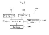
- Fig. 3 shows a path search server according to another embodiment of the present invention.
- the path search server 220 includes an input unit 300, a display unit 310, a controller 320, a communication module 330 and database 340 as shown in FIG. 3.
- the input unit 300 such as a keyboard is used to input information for an operator to update/search map database and manage performance, fee and a terminal.
- the display unit 310 displays data necessary for the operator.
- the controller 320 performs entire control.
- the communication module 330 communicates with the car navigation apparatus.
- the controller 320 performs entire control according to an execution command received from the input unit 300 and provides the display unit 310 with information requested by the operator.
- the controller 320 extracts information requested by the car navigation system apparatus from the database 340 and transmits the extracted information through the communication module 330.
- the database 340 includes electronic a map database, a path calculation database, a facility database, and a terminal and system management database.
- the electronic map database includes road information, background information, traffic information and administration and facility information.
- the road information includes information describing the road shape and information describing intersections which are positioned along the road.
- the background information may include water systems such as rivers and lakes.
- the electronic map database is updated by traffic information and road information inputted by an information provider.
- the electronic map database is transmitted to a terminal required to update information or is used as information which an operator can confer to.
- the path calculation database is road network database configured so as to calculate an optimal path if information on departure and destination necessary to calculate a path is received from the car navigation apparatus.
- the path calculation database is made of a network including weights of a link, a node, time and distance between the link and the node.
- the facility database can be provided immediately when the car navigation apparatus requests to be provided with information on a specific facility or a list of facilities near to a specific location.
- the facility database includes a list of facilities, detailed location information on each facility, and name and phone number of a company located in each facility.
- the terminal and system management database includes a subscriber terminal ID, user information, last used time of a terminal, last update time of the terminal, and server information use contents.
- the database 340 as described above is updated by an information provider in real time or at predetermined intervals.
- Fig. 4 shows a car navigation apparatus according to another embodiment of the present invention.
- the car navigation apparatus 210 includes a GPS receiver 400, an estimation location sensor 410 and a map storage 420 as shown in Fig. 4.
- the GPS receiver 400 receives a GPS satellite signal.
- the estimation location sensor 410 calculates travel distance information of a moving object and travel direction information.
- the map storage 420 stores navigation map data.
- the car navigation apparatus 210 further includes a memory means 430, an input unit 440, a display unit 450, and an audio unit 460.
- the memory means 430 stores temporarily data to be calculated.
- the input unit 440 allows a user to input a desired command.
- the display unit 450 displays a processed result.
- the audio unit 460 outputs the processed result in sound.
- the car navigation apparatus 210 further includes a communication module 470 and a controller 480.
- the communication module 470 provides an interface to communicate with a base station.
- the controller 480 controls and processes the components at a center.
- the controller 480 receives map update information from a path search server, the controller 480 reconstructs map information stored in the map storage 420 and reproduces guidance information according to the received map update information.
- the map storage 420 stores map display data, path guidance data and facility list data. Additionally, the map storage 420 stores map information and guidance information transmitted from the controller 480.
- the controller 480 transmits the inputted destination information and map version information to the path search server through the communication module 470.
- the controller 480 determines whether a node to which the map update information is inputted exists while scanning the search path. As a result of determination, if a node to which the map update information is inputted exists, the controller 480 reconstructs a link according to the map update information, extracts guidance information including an attribute of a corresponding node and an attribute of a connection link, and stores the extracted attribute of the corresponding node and the extracted attribute of the connection link in a link.
- the reconstructed path information and the guidance information are outputted through the display unit 450 and the audio unit 460 and are stored in the map storage 420 at the same time.
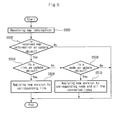
- Fig. 5 is a flowchart showing a map version management method of a path search server according to another embodiment of the present invention.
- the path search server according to the present invention receives map information (S500), it is determined whether the received map information is an update object (S502).
- the path search server determines whether the received map information is an update object, using size of update information, node coordinate matching range, node sequence inversion tolerance of the search path, map matching error tolerance range of existing shape of path guidance and change of information type.
- the path search server determines whether the link is an update object (S504). As the result of determination at the step S504, if the link is the update object, the path search server determines whether a new version is applied to a corresponding link (S506). For example, if the links b-c and c-d are update objects for the simply connected nodes a, b, c, d, e and f, the new version is given to the links b-c and c-d. As the result of determination at the step S504, if the link is not the update object, the path search server determines whether the node is an update object (S508).
- the path search server applies a new version to the corresponding node and all the connected links (S510). For example, when the update object has connection links forming the links a-b, a-c and a-d for the node a, the new version is commonly applied to the links a-b, a-c and a-d. Then, a map updating method according to another embodiment of the present invention will be applied.
- Fig. 6 is a flowchart showing a real time map updating method according to another embodiment of the present invention.
- the car navigation apparatus receives destination information from a user (S600)
- the car navigation apparatus transmits the received destination information and map version information to the path search server (S602).
- the path search server searches for a path corresponding to destination information transmitted from the car navigation apparatus (S604). Then, the path search server scans each link in the search path and constructs search path information (S606). The path search server transmits the search path information to the car navigation apparatus (S608). The method in which the path search server constructs search path information will be described later referring to Fig. 7.
- the car navigation apparatus receives search path information (S610), and then constructs link while scanning from the departure node to the destination node (S612).
- the method of constructing link while scanning from the departure node to the destination node will be described later referring to Fig. 8.
- the car navigation apparatus creates and stores (S614) the guidance information according to the constructed link.
- the guidance information includes screen display surrounding shape, path guidance indexing information and path deviation determination information.
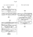
- FIG. 7 is a flowchart showing a method of constructing search path information at the path search server according to another embodiment of the present invention.
- the path search server When the path search server according to the present invention receives map version information and departure/destination information from the car navigation apparatus (S700), the path search server searches for a path corresponding to the received destination information as shown in FIG. 7 (S702).
- the path search server scans from the departure link to the destination link of the search path (S704), and determines whether a current link version corresponds to a map version of the car navigation apparatus (S706).
- the term current link refers to the link that is currently being processed.
- next link refers to the link in a search path that follows the link which is currently being processed.
- the path search server inputs information on whether to update to a rear node of the search path (S710), and extracts an attribute of the extracted rear node and an attribute of the connection link (S712).
- the attribute of the extracted rear node and the attribute of the connection link are transmitted so as to create guidance information on a map update portion, and include a node type, a node name, connection link shape, road type, link type, traffic regulation, facilities on a road, the number of lanes, width of a road, a road name, routing number and surrounding road shape of intersection of road dense region.
- the path search server communicates the inputted information on whether to update and update information with a node to construct search path information (S714).
- the update information includes the attribute of the extracted corresponding rear node and the attribute of the connection link.
- the car navigation apparatus index update information to a rear node of a path search result node sequence so as to determine whether to update on the basis of entrance link to a transmission node. For example, if links b-c and c-d are update objects for successive nodes a, b, c, d, e and f, only c of the nodes which the path search server transmits is indexed as an update object.
- link d-e is an update object for the successive nodes a, b, c, d, e and f
- the path search server removes duplicate of node coordinates of both ends of a link (S716).
- the search path information is transmitted to the car navigation apparatus (S718).
- the path search server constructs search path information from node coordinates of both ends of the link (S720) and performs the step S716.
- FIG. 8 is a flowchart showing a method of constructing link with scanning from a start node to destination node at the car navigation apparatus according to another embodiment of the present invention.
- the car navigation apparatus When the car navigation apparatus according to the present invention receives destination information from a user (S800), the car navigation apparatus transmits the received destination information and map version information to the path search server (S802) as shown in FIG. 8.
- the path search server searches for a path corresponding to the destination information and transmits the search path information to the car navigation apparatus.
- the car navigation apparatus When the car navigation apparatus receives search path information from the path search server (S804), the car navigation apparatus scans from the departure link to the destination link (S806), and determines whether a current node version corresponds to a stored map version (S808). In other words, the car navigation apparatus determines whether the current node includes update information inputted from the path search server.
- the car navigation apparatus extracts an attribute of the current node and an attribute of a connection link (S810).
- car navigation apparatus extracts the attribute of the current node and the attribute of the connection link from the update information if the current node includes update information.
- the car navigation apparatus determines whether a previous node of the current node is an old version (S812).
- previous node refers to a node which is preceding a current node in a link that connects two or more nodes.
- the car navigation apparatus determines a matching one of connection links of the previous node and the current node as a path link and reconstructs a link (S814). After performing the step S814, the car navigation apparatus stores the extracted guidance information in the reconstructed link (S816).
- the guidance information includes an attribute of the extracted node and an attribute of the connection link.
- step S812 if the previous node of the current node is the old version, the car navigation apparatus matches node coordinates and determines a link (S818). Then, the step S816 is performed. As a result of the step S808, if the current node version corresponds to the stored map version, the car navigation apparatus matches node coordinates and extracts corresponding node coordinates from the stored map (S820).
- the car navigation apparatus matches the extracted node coordinates and determines a link (S822).
- the car navigation apparatus stores guidance information in the determined link (S824).
- the car navigation apparatus can receive the update information and use for guidance, so that quality of user provision service can be improved.
- a server since information on whether to update a map is given to a link, a server can easily check whether a map-updated link is included in a search path, and a terminal receives a node to determine the link and whether to update the map.
- map update contents are not used in a terminal map in real time but only the information required to guide is extracted and transmitted through communication connection between a server and a terminal, the overhead in which all the information including the information that is not required for the current guidance should be received can be avoided.
Applications Claiming Priority (2)
| Application Number | Priority Date | Filing Date | Title |
|---|---|---|---|
| KR2003043954 | 2003-06-30 | ||
| KR10-2003-0043954A KR100539834B1 (ko) | 2003-06-30 | 2003-06-30 | 차량 항법 유도 장치를 이용한 지도 버전 관리 방법 및시스템 |
Publications (3)
| Publication Number | Publication Date |
|---|---|
| EP1493992A2 true EP1493992A2 (de) | 2005-01-05 |
| EP1493992A3 EP1493992A3 (de) | 2006-03-01 |
| EP1493992B1 EP1493992B1 (de) | 2008-05-07 |
Family
ID=33432449
Family Applications (1)
| Application Number | Title | Priority Date | Filing Date |
|---|---|---|---|
| EP04015201A Expired - Fee Related EP1493992B1 (de) | 2003-06-30 | 2004-06-29 | Fahrzeugnavigationssystem und Kartenversionsverwaltungsverfahren |
Country Status (6)
| Country | Link |
|---|---|
| US (1) | US7317986B2 (de) |
| EP (1) | EP1493992B1 (de) |
| JP (1) | JP2005024555A (de) |
| KR (1) | KR100539834B1 (de) |
| CN (1) | CN100429481C (de) |
| DE (1) | DE602004013494D1 (de) |
Cited By (4)
| Publication number | Priority date | Publication date | Assignee | Title |
|---|---|---|---|---|
| DE102005053125A1 (de) * | 2005-11-08 | 2007-05-10 | Bayerische Motoren Werke Ag | Verfahren zur Aktualisierung von Kartendaten eines Navigationssystems und System zur Aktualisierung von Kartendaten eines Navigationssystems |
| EP1834679A1 (de) * | 2006-03-15 | 2007-09-19 | Kabushiki Kaisha Square Enix (also trading as Square Enix Co., Ltd.) | Videospielverarbeitungsgerät, Verfahren und Computerprogrammprodukt zur Verarbeitung eines Videospiels |
| EP1965171A3 (de) * | 2007-02-27 | 2010-10-06 | Aisin AW Co., Ltd. | System zur Aktualisierung von Karteninformationen |
| US9347778B2 (en) | 2007-12-28 | 2016-05-24 | Here Global B.V. | Managing differences between geographic database versions |
Families Citing this family (43)
| Publication number | Priority date | Publication date | Assignee | Title |
|---|---|---|---|---|
| JP4162959B2 (ja) * | 2002-09-27 | 2008-10-08 | 株式会社ザナヴィ・インフォマティクス | 地図データ処理装置 |
| KR100539834B1 (ko) * | 2003-06-30 | 2005-12-28 | 엘지전자 주식회사 | 차량 항법 유도 장치를 이용한 지도 버전 관리 방법 및시스템 |
| US7561546B2 (en) * | 2004-01-08 | 2009-07-14 | Interdigital Technology Corporation | Wireless communication method and apparatus for managing radio resources using silent measurement periods |
| JP4645203B2 (ja) * | 2005-01-19 | 2011-03-09 | 株式会社ケンウッド | 案内経路生成装置および案内経路生成方法 |
| CN102592497B (zh) * | 2005-04-08 | 2014-05-14 | 知识产权之桥一号有限责任公司 | 地图信息更新装置及地图信息更新方法 |
| CN100459762C (zh) * | 2005-09-13 | 2009-02-04 | 集嘉通讯股份有限公司 | 动态更新景点数据的移动通信装置、系统及方法 |
| JP2007120973A (ja) * | 2005-10-25 | 2007-05-17 | Denso Corp | 移動体用アプリケーション実行装置 |
| ATE462956T1 (de) * | 2006-03-31 | 2010-04-15 | Research In Motion Ltd | Verfahren zur kontrolle von kartenversionen und vorrichtung zur aktualisierung der verwendung von über ein netzwerk gewarteten kartendatensätzen für mobile kommunikationsvorrichtungen |
| JP4938351B2 (ja) * | 2006-05-16 | 2012-05-23 | トヨタ自動車株式会社 | 車両用測位情報更新装置 |
| JP4995499B2 (ja) * | 2006-06-23 | 2012-08-08 | アイシン・エィ・ダブリュ株式会社 | 地図情報配信システム |
| JP4877876B2 (ja) * | 2006-07-10 | 2012-02-15 | アイシン・エィ・ダブリュ株式会社 | 地図情報配信システム及び地図情報配信方法 |
| JP4588670B2 (ja) * | 2006-07-10 | 2010-12-01 | アイシン・エィ・ダブリュ株式会社 | 地図情報配信センタ及び地図情報配信方法 |
| DE102006034407A1 (de) * | 2006-07-25 | 2008-01-31 | Robert Bosch Gmbh | Aktualisierungsverfahren für Datenbasen, insbesondere Navigationsdatenbasen |
| KR20080017610A (ko) * | 2006-08-21 | 2008-02-27 | 한국전자통신연구원 | 탐색 경로에 기반한 단말기의 지도정보 갱신방법 및 이를위한 서버 |
| CN101078633B (zh) * | 2007-06-12 | 2010-05-19 | 江苏华科导航科技有限公司 | 导航装置的地图数据更新方法 |
| CN101183011B (zh) * | 2007-12-27 | 2011-08-31 | 深圳市赛格导航科技股份有限公司 | Gps导航方法及系统 |
| CN101319911B (zh) * | 2008-07-02 | 2012-02-01 | 深圳市凯立德科技股份有限公司 | 一种导航系统的客户端、服务端、及进行地图更新的方法 |
| JP4666066B2 (ja) * | 2008-12-03 | 2011-04-06 | 株式会社デンソー | 地図データ利用装置 |
| JP5752357B2 (ja) * | 2009-02-13 | 2015-07-22 | アイシン・エィ・ダブリュ株式会社 | ナビゲーション装置及び地図情報更新方法 |
| CN102341832B (zh) * | 2009-03-12 | 2014-10-22 | 丰田自动车株式会社 | 信息提供方法、信息提供系统和构成该信息提供系统的信息提供中心以及车载机 |
| JP5316292B2 (ja) * | 2009-07-31 | 2013-10-16 | アイシン・エィ・ダブリュ株式会社 | 地図情報案内装置、地図情報案内方法及びコンピュータプログラム |
| DE112009005295B4 (de) * | 2009-10-21 | 2014-07-03 | Mitsubishi Electric Corporation | Karteninformations-Verarbeitungsvorrichtung |
| US20110227723A1 (en) * | 2010-03-17 | 2011-09-22 | General Electric Company | Remote machine monitoring |
| US8583367B2 (en) | 2011-01-07 | 2013-11-12 | Honda Motor Co., Ltd. | System and method for displaying a route based on a vehicle state |
| CN102074159B (zh) * | 2011-02-01 | 2013-07-17 | 北京汉风和科技发展有限公司 | 一种电子地图指路方法 |
| US9075822B2 (en) * | 2011-02-11 | 2015-07-07 | Here Global B.V. | Incremental testing of a navigation database |
| ITTO20110850A1 (it) * | 2011-09-23 | 2013-03-24 | Sisvel Technology Srl | Metodo per gestire una mappa di un dispositivo di navigazione personale e relativo dispositivo |
| CN103067499A (zh) * | 2012-12-27 | 2013-04-24 | 科世达(上海)管理有限公司 | 一种数据处理方法及装置 |
| US9709407B2 (en) | 2013-01-30 | 2017-07-18 | Nokia Technologies Oy | Method and apparatus for use in navigational applications |
| CN103196454A (zh) * | 2013-03-22 | 2013-07-10 | 方宗尧 | 导航终端产品电子地图用户标定和无线管理方法 |
| US9696885B2 (en) * | 2013-09-20 | 2017-07-04 | International Business Machines Corporation | Integrated user interface using linked data |
| CN103438893A (zh) * | 2013-09-25 | 2013-12-11 | 广州派腾知识产权服务有限公司 | 一种支持车载导航仪在线更新地图的方法 |
| US20150185029A1 (en) * | 2013-12-31 | 2015-07-02 | Hyundai Motor Company | Map version synchronization path search method |
| US10317222B2 (en) | 2015-06-22 | 2019-06-11 | Here Global B.V. | Decision-based map-agnostic navigation routing |
| US9933269B2 (en) | 2015-06-22 | 2018-04-03 | Here Global B.V. | Midpoint-based map-agnostic navigation routing |
| US10935390B2 (en) * | 2016-03-28 | 2021-03-02 | Aisin Aw Co., Ltd. | Communication terminal, server device, movement guidance system, and computer program |
| JP6718715B2 (ja) | 2016-03-28 | 2020-07-08 | アイシン・エィ・ダブリュ株式会社 | 通信端末、サーバ装置、移動案内システム及びコンピュータプログラム |
| CN107957268A (zh) * | 2016-10-18 | 2018-04-24 | 菜鸟智能物流控股有限公司 | 导航数据生成方法及相关设备、物体运送方法及相关设备 |
| CN108306924B (zh) * | 2017-09-12 | 2021-06-29 | 福建联迪商用设备有限公司 | 一种通讯方法、通信终端、云服务器及通讯系统 |
| CN107798420B (zh) * | 2017-09-28 | 2021-11-05 | 北京三快在线科技有限公司 | 信息显示的方法及装置、电子设备 |
| US10365660B2 (en) * | 2017-10-31 | 2019-07-30 | Savioke, Inc. | Computer system and method for automated indoor surveying by robots |
| DE102020114619A1 (de) | 2020-06-02 | 2021-12-02 | Bayerische Motoren Werke Aktiengesellschaft | Computerimplementiertes Verfahren und System zur nutzungsgesteuerten Diensteauslieferung an ein Onboard-System eines Fahrzeugs |
| US20230280180A1 (en) * | 2022-03-01 | 2023-09-07 | Argo AI, LLC | Systems and methods for performing data collection missions |
Citations (1)
| Publication number | Priority date | Publication date | Assignee | Title |
|---|---|---|---|---|
| EP1102228A2 (de) * | 1999-11-18 | 2001-05-23 | Kabushikikaisha Equos Research | Navigationssystem unter Verwendung der von einer Zentralstation übertragenen Routeninformationen |
Family Cites Families (13)
| Publication number | Priority date | Publication date | Assignee | Title |
|---|---|---|---|---|
| US6507872B1 (en) * | 1992-09-25 | 2003-01-14 | David Michael Geshwind | Class of methods for improving perceived efficiency of end-user interactive access of a large database such as the world-wide web via a communication network such as “The Internet” |
| US6415307B2 (en) * | 1994-10-24 | 2002-07-02 | P2I Limited | Publication file conversion and display |
| US6680694B1 (en) * | 1997-08-19 | 2004-01-20 | Siemens Vdo Automotive Corporation | Vehicle information system |
| JP2002506197A (ja) * | 1997-08-19 | 2002-02-26 | シーメンス オートモーティヴ コーポレイション | 車両情報システム |
| JPH11224047A (ja) * | 1998-02-06 | 1999-08-17 | Matsushita Electric Ind Co Ltd | 地図情報提供方法及びそれに用いられる端末装置 |
| US6684221B1 (en) * | 1999-05-06 | 2004-01-27 | Oracle International Corporation | Uniform hierarchical information classification and mapping system |
| JP3589124B2 (ja) * | 1999-11-18 | 2004-11-17 | トヨタ自動車株式会社 | ナビゲーション装置 |
| JP4566413B2 (ja) * | 2001-01-10 | 2010-10-20 | 三菱電機株式会社 | 地図情報処理装置 |
| US7430535B2 (en) * | 2001-01-27 | 2008-09-30 | General Electric Capital Corporation | Methods and systems for identifying prospective customers and managing deals |
| JP4663136B2 (ja) * | 2001-01-29 | 2011-03-30 | パナソニック株式会社 | デジタル地図の位置情報伝達方法と装置 |
| US7162526B2 (en) * | 2001-01-31 | 2007-01-09 | International Business Machines Corporation | Apparatus and methods for filtering content based on accessibility to a user |
| EP1481346B1 (de) * | 2002-02-04 | 2012-10-10 | Cataphora, Inc. | Verfahren und vorrichtung zur visuellen präsentation von diskussionen zum zwecke des sammelns von daten |
| KR100539834B1 (ko) * | 2003-06-30 | 2005-12-28 | 엘지전자 주식회사 | 차량 항법 유도 장치를 이용한 지도 버전 관리 방법 및시스템 |
-
2003
- 2003-06-30 KR KR10-2003-0043954A patent/KR100539834B1/ko active IP Right Grant
-
2004
- 2004-06-28 JP JP2004189901A patent/JP2005024555A/ja not_active Withdrawn
- 2004-06-29 EP EP04015201A patent/EP1493992B1/de not_active Expired - Fee Related
- 2004-06-29 DE DE602004013494T patent/DE602004013494D1/de not_active Expired - Fee Related
- 2004-06-30 CN CNB200410062556XA patent/CN100429481C/zh not_active Expired - Fee Related
- 2004-06-30 US US10/882,840 patent/US7317986B2/en active Active
Patent Citations (1)
| Publication number | Priority date | Publication date | Assignee | Title |
|---|---|---|---|---|
| EP1102228A2 (de) * | 1999-11-18 | 2001-05-23 | Kabushikikaisha Equos Research | Navigationssystem unter Verwendung der von einer Zentralstation übertragenen Routeninformationen |
Cited By (8)
| Publication number | Priority date | Publication date | Assignee | Title |
|---|---|---|---|---|
| DE102005053125A1 (de) * | 2005-11-08 | 2007-05-10 | Bayerische Motoren Werke Ag | Verfahren zur Aktualisierung von Kartendaten eines Navigationssystems und System zur Aktualisierung von Kartendaten eines Navigationssystems |
| WO2007054180A1 (de) * | 2005-11-08 | 2007-05-18 | Bayerische Motoren Werke Aktiengesellschaft | Verfahren zur aktualisierung von kartendaten eines navigationssystems und system zur aktualisierung von kartendaten eines navigationssystems |
| US8428868B2 (en) | 2005-11-08 | 2013-04-23 | Bayerische Motoren Werke Aktiengesellschaft | Method and system for updating card data of a navigation system |
| EP1834679A1 (de) * | 2006-03-15 | 2007-09-19 | Kabushiki Kaisha Square Enix (also trading as Square Enix Co., Ltd.) | Videospielverarbeitungsgerät, Verfahren und Computerprogrammprodukt zur Verarbeitung eines Videospiels |
| US7677977B2 (en) | 2006-03-15 | 2010-03-16 | Kabushiki Kaisha Square Enix | Video game processing apparatus, a method and a computer program product for processing a video game |
| EP1965171A3 (de) * | 2007-02-27 | 2010-10-06 | Aisin AW Co., Ltd. | System zur Aktualisierung von Karteninformationen |
| US8660787B2 (en) | 2007-02-27 | 2014-02-25 | Aisin Aw Co., Ltd. | Map information updating systems, methods, and programs |
| US9347778B2 (en) | 2007-12-28 | 2016-05-24 | Here Global B.V. | Managing differences between geographic database versions |
Also Published As
| Publication number | Publication date |
|---|---|
| CN100429481C (zh) | 2008-10-29 |
| EP1493992B1 (de) | 2008-05-07 |
| CN1576795A (zh) | 2005-02-09 |
| EP1493992A3 (de) | 2006-03-01 |
| US7317986B2 (en) | 2008-01-08 |
| KR20050002654A (ko) | 2005-01-10 |
| US20040267441A1 (en) | 2004-12-30 |
| KR100539834B1 (ko) | 2005-12-28 |
| DE602004013494D1 (de) | 2008-06-19 |
| JP2005024555A (ja) | 2005-01-27 |
Similar Documents
| Publication | Publication Date | Title |
|---|---|---|
| EP1493992B1 (de) | Fahrzeugnavigationssystem und Kartenversionsverwaltungsverfahren | |
| US7860645B2 (en) | System and method for providing telematics service | |
| US8010227B2 (en) | Navigation system with downloadable map data | |
| US20020128768A1 (en) | Route guide information distributing system | |
| US20070276597A1 (en) | Navigation Apparatus and Route Guiding Method | |
| US20080004803A1 (en) | Navigation System, Route Search Device, Navigation Device, and Program | |
| US20100312465A1 (en) | Method and apparatus for navigation system using routing data created by remote navigation server | |
| US20090240426A1 (en) | Navigation device and navigation method | |
| KR20040054524A (ko) | 내비게이션 장치 및 상기 장치용 프로그램 및 기록 매체 | |
| EP1536394A2 (de) | Telematisches System das Bilddaten benützt, und Methode zur Führung eines Fahrzeugs entlang einer berechneten Route Mithilfe desselben | |
| KR20040073270A (ko) | 내비게이션 장치 및 상기 장치용 프로그램 및 기록 매체 | |
| EP3441723A1 (de) | Navigationssystem und verfahren zum austausch von wechselseitigen ortsinformationen unter verwendung eines kuriers | |
| CN108779987B (zh) | 通信终端、服务器装置、路径搜索系统以及计算机程序 | |
| JP2017181103A (ja) | 通信端末、サーバ装置、移動案内システム及びコンピュータプログラム | |
| JP2008249539A (ja) | 地図表示システム、端末装置、地図表示サーバ及び地図表示方法 | |
| JP2006065246A (ja) | カーナビゲーション装置の地図データ更新方法、地図データ更新システム、カーナビゲーション装置、地図情報サーバ | |
| JP2006275777A (ja) | ナビゲーション装置、地図データ更新システム、地図データ更新方法 | |
| JP6646731B2 (ja) | サーバ装置、通信端末、経路探索システム及びコンピュータプログラム | |
| US7822542B2 (en) | Location information exchange apparatus and location information exchange method | |
| JP4018518B2 (ja) | ナビゲーションシステム | |
| JP2018004791A (ja) | サーバ装置、通信端末、情報配信システム及びコンピュータプログラム | |
| JP2018010320A (ja) | サーバ装置、端末装置、情報処理方法並びに情報処理システム及び情報処理プログラム | |
| JP2005241613A (ja) | ナビゲーションシステム | |
| JP6834693B2 (ja) | 通信端末、移動案内システム及びコンピュータプログラム | |
| JP4779401B2 (ja) | ナビゲーション装置、地図データ更新システム、地図データ更新方法 |
Legal Events
| Date | Code | Title | Description |
|---|---|---|---|
| PUAI | Public reference made under article 153(3) epc to a published international application that has entered the european phase |
Free format text: ORIGINAL CODE: 0009012 |
|
| AK | Designated contracting states |
Kind code of ref document: A2 Designated state(s): AT BE BG CH CY CZ DE DK EE ES FI FR GB GR HU IE IT LI LU MC NL PL PT RO SE SI SK TR |
|
| AX | Request for extension of the european patent |
Extension state: AL HR LT LV MK |
|
| PUAL | Search report despatched |
Free format text: ORIGINAL CODE: 0009013 |
|
| AK | Designated contracting states |
Kind code of ref document: A3 Designated state(s): AT BE BG CH CY CZ DE DK EE ES FI FR GB GR HU IE IT LI LU MC NL PL PT RO SE SI SK TR |
|
| AX | Request for extension of the european patent |
Extension state: AL HR LT LV MK |
|
| RIC1 | Information provided on ipc code assigned before grant |
Ipc: G01C 21/34 20060101ALI20060110BHEP Ipc: G01C 21/26 20060101AFI20041007BHEP |
|
| 17P | Request for examination filed |
Effective date: 20060830 |
|
| 17Q | First examination report despatched |
Effective date: 20061005 |
|
| AKX | Designation fees paid |
Designated state(s): DE GB NL |
|
| GRAP | Despatch of communication of intention to grant a patent |
Free format text: ORIGINAL CODE: EPIDOSNIGR1 |
|
| GRAS | Grant fee paid |
Free format text: ORIGINAL CODE: EPIDOSNIGR3 |
|
| GRAA | (expected) grant |
Free format text: ORIGINAL CODE: 0009210 |
|
| AK | Designated contracting states |
Kind code of ref document: B1 Designated state(s): DE GB NL |
|
| REG | Reference to a national code |
Ref country code: GB Ref legal event code: FG4D |
|
| REF | Corresponds to: |
Ref document number: 602004013494 Country of ref document: DE Date of ref document: 20080619 Kind code of ref document: P |
|
| PG25 | Lapsed in a contracting state [announced via postgrant information from national office to epo] |
Ref country code: NL Free format text: LAPSE BECAUSE OF FAILURE TO SUBMIT A TRANSLATION OF THE DESCRIPTION OR TO PAY THE FEE WITHIN THE PRESCRIBED TIME-LIMIT Effective date: 20080507 |
|
| NLV1 | Nl: lapsed or annulled due to failure to fulfill the requirements of art. 29p and 29m of the patents act | ||
| PLBE | No opposition filed within time limit |
Free format text: ORIGINAL CODE: 0009261 |
|
| STAA | Information on the status of an ep patent application or granted ep patent |
Free format text: STATUS: NO OPPOSITION FILED WITHIN TIME LIMIT |
|
| 26N | No opposition filed |
Effective date: 20090210 |
|
| GBPC | Gb: european patent ceased through non-payment of renewal fee |
Effective date: 20080807 |
|
| PG25 | Lapsed in a contracting state [announced via postgrant information from national office to epo] |
Ref country code: DE Free format text: LAPSE BECAUSE OF NON-PAYMENT OF DUE FEES Effective date: 20090101 |
|
| REG | Reference to a national code |
Ref country code: GB Ref legal event code: S28 Free format text: APPLICATION FILED |
|
| PG25 | Lapsed in a contracting state [announced via postgrant information from national office to epo] |
Ref country code: GB Free format text: LAPSE BECAUSE OF NON-PAYMENT OF DUE FEES Effective date: 20080807 |
|
| REG | Reference to a national code |
Ref country code: GB Ref legal event code: S28 Free format text: RESTORATION ALLOWED Effective date: 20100119 |
|
| PGFP | Annual fee paid to national office [announced via postgrant information from national office to epo] |
Ref country code: GB Payment date: 20190503 Year of fee payment: 16 |
|
| GBPC | Gb: european patent ceased through non-payment of renewal fee |
Effective date: 20200629 |
|
| PG25 | Lapsed in a contracting state [announced via postgrant information from national office to epo] |
Ref country code: GB Free format text: LAPSE BECAUSE OF NON-PAYMENT OF DUE FEES Effective date: 20200629 |