EP1308917A1 - Système fournissant des données de l'état de route - Google Patents
Système fournissant des données de l'état de route Download PDFInfo
- Publication number
- EP1308917A1 EP1308917A1 EP02257458A EP02257458A EP1308917A1 EP 1308917 A1 EP1308917 A1 EP 1308917A1 EP 02257458 A EP02257458 A EP 02257458A EP 02257458 A EP02257458 A EP 02257458A EP 1308917 A1 EP1308917 A1 EP 1308917A1
- Authority
- EP
- European Patent Office
- Prior art keywords
- vehicle
- status data
- server
- unit
- information
- Prior art date
- Legal status (The legal status is an assumption and is not a legal conclusion. Google has not performed a legal analysis and makes no representation as to the accuracy of the status listed.)
- Granted
Links
Images


Classifications
-
- G—PHYSICS
- G08—SIGNALLING
- G08G—TRAFFIC CONTROL SYSTEMS
- G08G1/00—Traffic control systems for road vehicles
- G08G1/09—Arrangements for giving variable traffic instructions
- G08G1/0962—Arrangements for giving variable traffic instructions having an indicator mounted inside the vehicle, e.g. giving voice messages
- G08G1/0968—Systems involving transmission of navigation instructions to the vehicle
- G08G1/096805—Systems involving transmission of navigation instructions to the vehicle where the transmitted instructions are used to compute a route
- G08G1/096811—Systems involving transmission of navigation instructions to the vehicle where the transmitted instructions are used to compute a route where the route is computed offboard
-
- G—PHYSICS
- G08—SIGNALLING
- G08G—TRAFFIC CONTROL SYSTEMS
- G08G1/00—Traffic control systems for road vehicles
- G08G1/01—Detecting movement of traffic to be counted or controlled
- G08G1/0104—Measuring and analyzing of parameters relative to traffic conditions
-
- G—PHYSICS
- G08—SIGNALLING
- G08G—TRAFFIC CONTROL SYSTEMS
- G08G1/00—Traffic control systems for road vehicles
- G08G1/09—Arrangements for giving variable traffic instructions
- G08G1/0962—Arrangements for giving variable traffic instructions having an indicator mounted inside the vehicle, e.g. giving voice messages
- G08G1/0968—Systems involving transmission of navigation instructions to the vehicle
- G08G1/096833—Systems involving transmission of navigation instructions to the vehicle where different aspects are considered when computing the route
- G08G1/096838—Systems involving transmission of navigation instructions to the vehicle where different aspects are considered when computing the route where the user preferences are taken into account or the user selects one route out of a plurality
-
- G—PHYSICS
- G08—SIGNALLING
- G08G—TRAFFIC CONTROL SYSTEMS
- G08G1/00—Traffic control systems for road vehicles
- G08G1/09—Arrangements for giving variable traffic instructions
- G08G1/0962—Arrangements for giving variable traffic instructions having an indicator mounted inside the vehicle, e.g. giving voice messages
- G08G1/0968—Systems involving transmission of navigation instructions to the vehicle
- G08G1/096833—Systems involving transmission of navigation instructions to the vehicle where different aspects are considered when computing the route
- G08G1/096844—Systems involving transmission of navigation instructions to the vehicle where different aspects are considered when computing the route where the complete route is dynamically recomputed based on new data
Definitions
- This invention relates to a road status data providing system, and a server and a vehicle terminal for providing road status data.
- a conventional navigation device is mounted in a vehicle (mounted in shipment of the vehicle or installed afterwards) and generally executes road navigation for each vehicle using map data and a program for running a system which are stored in a large scale storage device such as a CD (COMPACT DISC), DVD (DIGITAL VERSATILE DISC or DIGITAL VIDEO DISC) , or HDD (HARD DISK DRIVE), etc.
- a CD COMPACT DISC
- DVD DIGITAL VERSATILE DISC or DIGITAL VIDEO DISC
- HDD HARD DISK DRIVE
- VICS VEHICLE INFORMATION AND COMMUNICATION SYSTEM
- jamming information received from the center of the VICS is distinguishably displayed on a map on a display installed in a vehicle, for example, like jamming in red and slight jamming in orange.
- the conventional display of a jamming status has a problem that it cannot be sufficiently ascertained whether the jamming on the same road shouldbe attributable to the vehicles running toward the same destination or different destinations.
- An object of this invention is to provide a road status data providing system including a server for transmitting/receiving data via a communication line and a plurality of vehicle terminals which computes the number of vehicles which may pass a prescribed point and a predetermined range around the predetermined point on the basis of a request from a vehicle terminal for a server (management center of the road status data providing system) about the road status data at the prescribed point or within the predetermined range, and transmits the road status data to the vehicle terminal of a requester.
- a road status data providing system including a server for transmitting/receiving data via a communication line and a plurality of vehicle terminals, said server comprising:
- totaling of road status data at any prescribed point requested by the vehicle terminal can be performed by the server using the vehicle trend management database and the totaling result can be transmitted to the vehicle terminal.
- the vehicle terminal transmits the present position information acquired by the present position determining unit at regular time intervals; and the server receives the present position information transmitted from the vehicle terminal and updates the vehicle trend management database as occasion demands on the basis of the present position information, whereby the present position of the vehicle in the vehicle trend management database is always managed.
- the totaling unit in the server totals the number of vehicles running toward the prescribed point on the basis of the status data requesting information transmitted from the vehicle terminal.
- the server further comprises a route searching unit for searching a route from the present position to the destination on the basis of destination information transmitted from the vehicle terminal.
- a navigation function is added and the set destination data can be used for totaling the number of vehicles running toward the prescribed point, thereby realizing more accurately totaling.
- the server further comprises an estimated route searching unit for estimating a destination of a vehicle to search the route to the destination for the vehicle which is managed by the vehicle trend management database and is not conducting the route searching.
- the vehicle trend management database in the server also stores the route searching result by the route searching unit and the estimated route searching result by the estimated route searching unit.
- the vehicle trend management database always accumulatively stores the newest searching result by the route searching unit and the estimated route searching result for each vehicle, which is used for next totaling processing.
- the estimated route searching unit in the server estimates the destination of a vehicle on the basis of the running direction of the vehicle and history information stored in the vehicle trend management database.
- the destination of the vehicle which has not set the destination can be estimated on the basis of the present position information transmitted at regular intervals and the past history information of the vehicle to estimate the route corresponding to the estimated destination, thereby acquiring a reasonable totaling result.
- the creating unit of the vehicle terminal creates the status data requesting information which includes position information for indicating the prescribed point, range information for specifying a prescribed range inclusive of the point and time information for setting a time when the status data is to be acquired.
- the totaling unit in the server defines roads crossing the outline of the range on the basis of the position information and range information with reference to the vehicle trend management database to total the number of vehicles which will run in the range using the roads at the time and set the point as a destination for each of the roads.
- an information providing server for transmitting/receiving data for a plurality of vehicle terminals via a communication line, comprising:
- the totaling processing in the road status at the prescribed point requested by a plurality of vehicle terminals can be requested can be performed in a unified way using the vehicle trend management database.
- the transmission/reception unit receives the present position information transmitted from the vehicle terminal, and the vehicle trend management database updates the vehicle trend management database as occasion demands on the basis of the present position information.
- the present position data of the vehicle stored in the road trend management database is always updated to the newest.
- the totaling unit totals the number of vehicles running toward the prescribed point on the basis of the status data requesting information transmitted by the vehicle terminal.
- the information providing server further comprises a route searching unit for searching a route from the present position to the destination on the basis of destination information transmitted from the vehicle terminal.
- a navigation function is added and the set destination data can be used for totaling the number of vehicles running toward the prescribed point, thereby realizing more accurately totaling.
- the information providing server further comprises an estimated route searching unit for estimating the destination of a vehicle to search the route to the destination for the vehicle which is managed by the vehicle trend management database and is not conducting the route searching.
- a vehicle terminal for transmitting/receiving data via a communication line for an information providing server, comprising:
- the vehicle terminal transmits the present position information acquired by the present position determining unit to the server at regular time intervals.
- the present position data of the vehicle stored in the road trend management server can always be updated to newest.
- the creating unit creates the status data requesting information which includes position information for indicating the prescribed point, range information for specifying a prescribed range inclusive of the point and time information for setting a time when the status data is to be acquired.
- the user can create the status data requesting information which includes position information for indicating the prescribed point, range information for specifying a prescribed range inclusive of the point and time information for setting a time when the status data is to be acquired, thereby easily requesting the server to provide the road status data.
- a program for providing road status data which causes the computer included in the vehicle terminal in the above-mentioned road status data providing system as a transmitting/receiving unit for transmitting/receiving data to and from the server; a present position determining unit for determining the present position of the vehicle; a creating unit for creating status data requesting information for acquiring the status data at the prescribed point.
- an information recording medium wherein the above program for providing the road status data according to claim 18 is recorded so as to be readable by the computer.
- Fig. 1 is a view showing the entire hardware configuration of a road status data providing system according to this invention.
- reference numeral 20 denotes a road status data providing system managing center (server) that is being managed by an enterprise which manages the road status data providing system according to this invention.
- Reference numerals 10, 11, 12 and 13 denote terminals for the road status data providing system, which are installed on vehicles, respectively. Theses terminals are connected to the road status data providing system managing center 20 via a communication network (inclusive of wireless communication by radio waves or optical communication).
- Fig. 2 is a block diagram showing the arrangement of the terminal which is mounted on a vehicle and used for the road status data providing system.
- reference 100 denotes a system control unit in which CPU for executing the entire management occupies a central position.
- Reference numeral 102 denotes a GPS (Global Positioning System) receivingunit
- reference numeral 103 denotes various sensors such as a gyro which is used to assist the measurement of the present position of a vehicle.
- Reference numeral 101 denotes a transmitting/receiving unit for transmitting/receiving data to and from the server through a communication line.
- Reference numeral 104 denotes a display unit for displaying a map and others.
- Reference numeral 105 denotes a voice guiding unit.
- Reference numeral 106 denotes an operation unit for executing data entry which can be used in combination with a keyboard or a speech input device.
- Fig. 3 is a block diagram showing the configuration of the server which is installed on the managing center 20 for the road status data providing system which executes the transmission/reception of data to and from the vehicle terminal 10 mounted on the vehicle through a communication line.
- reference numeral 200 denotes a system controlling unit in which CPU for executing the management of the server occupies a central position.
- Reference numeral 201 denotes a VICS data unit which receives the VICS information transmitted by a VICS providing station (not shown) and stores the received data on the jamming status of a road while updating them as occasion arises for use of various kinds of processing.
- Reference numeral 202 denotes a map information storage unit which stores map data necessary for the road status data providing system.
- the map data can include not only road information but also various items of data on facilities, tourist attraction, etc. in the neighborhood of the road at issue.
- the map information can also include data on construction and on an interrupting spot of the road.
- Reference numeral 203 denotes an individual database of users, under contract to the road status data providing system according to this invention.
- the road status data providing system serves as a useful system alone, but serves a more useful system in combination with a communication navigation system.
- a configuration in which a vehicle terminal sets a destination and transmits a request of searching a route from a present point to the destination to a server, and the server transmits the searching result to the vehicle terminal.
- the server has functions capable of executing both of road status data providing service and route searching service.
- the server has functions capable of executing both of road status data providing service and route searching service.
- the individual database 203 stores the information of the destination and present point of the pertinent vehicle received through the communication line and the result of the route searching as history information that is the data inclusive of the past data during a significant period.
- the individual database can be used for the processing of computation and charging of a fee using the communication navigation system.
- vehicle terminal 10 is shown alone in Fig. 4, data transmission/reception is carried out between the server 20 and a large number of vehicle terminals under contract to the road status data providing system.
- the power therefor is turned on when the engine of the vehicle is turned on.
- step S404 the present position of one's own vehicle, which is measured using the outputs from the GPS receiving unit 102 and various sensor units 103, is transmitted to the sever 20 (step S403) for executing the processing of position registering (step S404).
- this position registering processing of the vehicle is executed only once when the engine is turned on. However, usually, this is carried out repeatedly over a prescribed period so that the newest present position in formation of each vehicle is transmitted to the server 20.
- the server 20 receives the present position information of the vehicle and executes the position registering processing so that the present position information is registered in the individual database 203 (step S405).
- this present position registering permits the measured (estimated) value of the number of vehicles on the road to be computed (which is executed by the server 20 described later) more precisely by registering all the vehicles under contract to the road status data providing system in the server 20 to the individual database 203 regardless of whether the vehicle hopes guidance to the destination.
- step S406 the vehicle which hopes the navigation to the destination executes the processing of setting the destination (step S406) and transmits the point information of the destination (e.g. information of latitude/longitude) (step S407).
- point information of the destination e.g. information of latitude/longitude
- the server 20 when it receives the point information, executes the processing of searching the route between the present position of the pertinent vehicle and the destination (step S408).
- the route searching processing can be executed more exactly by using not only the map data stored in the map information storage unit 202 in Fig. 3 but also the VICS information stored in the VICS data unit 201 and the data on construction and on an interrupting spot of the road related to the route.
- the searching result data related to the searched route is transmitted to the vehicle which has requested the route searching (step S409).
- the vehicle terminal 10 which has received the route searching result displays the searching result on the display unit 104 (step S410).
- the server 20 saves the route searching result in the individual database 203 (step S411).
- the position registration and the transmission of the searching result are executed only once.
- the server 20 can always acquire the newest road status to execute the navigation to the destination more precisely.
- the server 20 transmits the route navigation information for navigating the vehicle equipped with the navigation terminal 10 to the vehicle terminal 10 (step S412).
- the vehicle terminal 10 displays the route navigation information on the display unit 104 (step S413).
- the user drives his own vehicle on the basis of the route searching result (route navigation information) which has been sequentially transmitted from the server.
- route searching result route navigation information
- the server 20 determines whether or not the pertinent vehicle has arrived at the destination on the basis of comparison between the present position information of the vehicle and the position of the destination. If the vehicle has arrived at the destination, the server 20 transmits an arrival notice signal to the server terminal 10.
- the vehicle terminal can also execute the processing of the step S415.
- the server 20 completes the route searching processing for the pertinent vehicle by the transmission of the arrival notice signal (step S416).
- step S417) If the driver turns OFF the engine when the vehicle has arrived at the destination (step S417), the vehicle terminal 10 executes the processing of turning OFF the power source (step S418).
- the server 20 release the position registration of the vehicle by turning OFF the power of vehicle terminal 10.
- Fig. 4 illustrates the flow of data in the route searching service (navigation service) which is preferably used in combination with the road status data providing system.
- the server 20 is in a situation where it receives the present position information of the pertinent vehicle at regular time intervals from the vehicle terminal 10 and consistently acquires the present position of the vehicle.
- the information of setting a destination is transmitted by the vehicle terminal 10 and received by the server 20 (step S501).
- the server 20 executes the route searching processing on the basis of the present position information of the pertinent vehicle and the requested destination information (step S502).
- the server 20 transmits the route searching result to the vehicle terminal 10 (step S503).
- step S504 In the decision whether or not the received route searching result is adopted (step S504), if the answer is YES (the route searching result is adopted), the pertinent vehicle is registered on the individual database 203 (step S505).
- the individual database 203 manages the present position information and destination information for each vehicle and the route information from the present position to the destination.
- step S504 determines whether the route searching result is adopted. If the decision of step S504 is NO (the route searching result is not adopted), the processing procedure returns to step S502 in which other route searching processing is executed again. This processing is executed repeatedly until the server receives the notice of adopting the route searching result from the pertinent vehicle.
- the server 20 route-navigates the pertinent vehicle on the basis of the route searching result, and continues to receive the present position information of the vehicle at regular time intervals (step S506).
- the server 20 checks whether or not there is the newest (best) route whenever the present position information of the pertinent vehicle is received (step S507).
- step S507 If there is a traffic jam on the route being used for navigation as a result of checking in step S507, the driver (user) of the pertinent vehicle is authorized to decide whether or not to execute a route change (step S508).
- step S507 If the user selects YES (route change) in the decision of step S507, the processing procedure returns to step S502 to execute the route searching again.
- step S507 decision is made on whether or not there is an navigation OFF command (step S509). If the server 20 receives the navigation OFF command (YES), it completes the route searching processing (END).
- step S510 If the server 20 does not receive the navigation OFF command, it is decided whether or not the vehicle has arrived at the destination by comparing the information on the present position of the vehicle with the position information of the destination (step S510).
- the step S510 corresponds to the "transmission of the arrival notice signal" in Fig. 4.
- whether or not the vehicle has arrived is decided by the server 20.
- this can be also decided by the vehicle terminal 10 mounted on the vehicle.
- the arrival notice signal (S415) in Fig. 4 is transmitted from the vehicle terminal 10 to the server 20.
- step S510 If the decision in step S510 is YES, the route searching processing is ended (END) . If the vehicle does not still arrive at the destination, the procedure from step S506 is repeated until the vehicle arrives at the destination.
- the server 20 when it receives the destination setting information from the vehicle terminal 10, executes the route searching and navigates the vehicle to the destination.
- the information on the present position and destination of each vehicle and the information of the route from the present position to the destination which are managed as a database, are used to compute (total) the information of providing (notifying) the status of vehicles at any point described later.
- the vehicle terminal 10 requests the provision (notice) of the status of vehicles (number of vehicles to pass) at a prescribed time at a prescribed point (e.g. point A).
- Fig. 6 the vehicle terminal 10 is shown alone. However, the vehicle terminals under contract to the road status data providing system according to this invention transmit/receive data to and from the server 20.
- the vehicle terminal 10 creates the request data for requesting the sever 20 to provide the number of vehicles (status of vehicles) running toward a set prescribed point or a prescribed area inclusive of the prescribed point (step S601) .
- Requested point data latitude of 35. 16. 0, longitude of 137.45.25
- Measured area data 500 m around Measured time data: a.m. 11:30
- the contents of this request data are to total the number of vehicles which advance in the destination of the range having a radius of 500 m around the point having the north latitude of 35.16.0 and east longitude of 137.45.25, which is a prescribed point, at a.m. 11:30 (for example for ten minutes before and after the time).
- the vehicle terminal 10 transmits the created request data to the server 20 (step S602).
- the server 20 executes the computing processing for totaling the vehicle data related to the prescribed point (inclusive of the prescribed area and prescribed time) included in the request data received from the vehicle terminal 10 by accessing the individual database 203.
- the individual database to be accessed of the vehicle terminals under contract to the road status data providing system is the vehicles with the data in operation (the engine key is ON) and includes the vehicles which run requesting the route searching for the set destination and the vehicle which run without setting the destination.
- the route searching corresponding to the destination can be made uniquely, whereas for the vehicle which is not requesting the route searching, the destination must be estimated to estimate the route (This processing is referred to as processing of searching the estimated route).
- the processing of searching the estimated route can determine the advancing direction (vector) of the vehicle by accumulating the position data sequentially at regular time intervals transmitted from the vehicle and hence estimate it in combination with the past history data of the pertinent vehicle stored in the individual database.
- the data acquired by the computing processing in step S603 is processed into the data for display in the requested format (step S604).
- the data thus created is transmitted from the server 20 to the vehicle terminal 10 (step S605).
- the received status of vehicles at the prescribed point is displayed on the display unit 104 (step S606).
- the vehicle terminal 10 creates the request data for requesting the server 20 to provide the number of vehicles running toward the destination (requesting point) or the prescribed area inclusive of the prescribed point (status of vehicles at the prescribed point) (step S701).
- the request data thus created is transmitted to the sever 20 (step S702).
- step S703 It is decided whether or not the vehicle terminal 10 has received the data of the totaled result for display from server 20 (step S703).
- the vehicle terminal 10 has received the data of the totaled result from the server 20, the received data is displayed on the display unit (step S704).
- the vehicle terminals under contract to the road status data providing system request the server 20 to total the road status data at the prescribed point from the vehicle terminal 10, and display the totaled result on the display unit mounted on the vehicle.
- the request data (data of a prescribed point, a prescribed range around the point and a prescribed time) is received from the vehicle terminal 10 (step S801).
- Computation is executed of the data of the number and passing direction of vehicles at the prescribed point and the prescribed range around the prescribed point (step S802).
- the data thus created is transmitted to the requesting vehicle terminal 10 (step S803).
- the server in the road status data providing system executes the totaling processing according to a request of totaling of the road status data at the prescribed point and and transmits the totaling result to the requesting vehicle terminal 10.
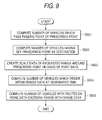
- the number of vehicles which pass a passing point (road adjacent to the prescribed point) of the prescribed point (requested point) is computed (step S901).
- the number of vehicles having set the point A as the destination (step S902) is computed.
- the number of vehicles which pass the prescribed point A in Fig. 10 includes not only the number of the vehicles having set the point A as the destination but also the vehicles which pass the point A.
- the number of vehicles is limited on the basis of the range data representative of the prescribed range around the prescribed point requested by the vehicle terminal 10 (step S903).
- the range data is 500 m. Therefore, the number of vehicles which are running toward the point A in the roads (R1, R2, R3) within the radius of 500 m around the point A as center can be computed.
- step S904 the number of vehicles is limited on the designated time.
- the number of vehicles residing within the requested range (radius of 500 m) at the designated time (AM 11:30) can be computed.
- the numbers of vehicles (about 70 vehicles on R1, about 200 vehicles on R2 and about 80 on R3) with the routes on the road data crossing the range with the range data are computed (step S905).
- the direction of crossing the range (running in or out from the range) is specified on the basis of the result of the route searching to create the data of the number of vehicles.
- the number of vehicles has been limited with reference to the inside of the circle within the radius represented by the range data.
- the shape for limiting may be an ellipse, square and not restricted to circle.
- processing of creating the data of the number and passing direction of vehicles at the prescribed point and prescribed range around the prescribed point is executed in the procedure of the prescribed point ⁇ prescribed range ⁇ prescribed time.
- Fig. 10 shows the number of vehicles which are to run toward within the range having a radius of 500 m around the point as center at an approximately prescribed time (AM 11:30), which is estimated at the present time AM 8:00.
- the display of the status of vehicles at the point A in Fig. 10 is based on the estimation at the present time AM 8:00. As the present time proceeds, the contents of display can be modified or changed according to the newest processing status in the server 20.
- Fig. 11 shows the number of vehicles which will run into the point A at about a prescribed time (AM10:00) when the measuring range having a radius of 1 km around the point A as center is specified as a range data from the vehicle terminal 10.
- the server 20 computes the number of vehicles which run into the prescribed range around the requested point using the accumulated individual database 203 and provides the computed result to the vehicle terminal 10.
- Fig. 12 shows the number of vehicles which run toward a prescribed point (point A) at the present time regardless of the range and time.
- This figures displays that there are three roads R21 to R23 running to the point A, and about 300 vehicles (R21), about 100 vehicles (R22) and about 500 vehicles (R23) are running toward the point A at the present time from the respective roads.
- Such a display permits the number of vehicles running toward the amusement facility located at the prescribed point A at the present time to know and is efficient to know the jamming status on the day.
- the amusement facility located at a prescribed point by transmitting the status data of vehicles data to the amusement facility located at a prescribed point, it can be used to estimate the number of visitors to the amusement facility in that day.
- Fig. 13 shows the number of vehicles running into the range data having a radius of 500 m around a prescribed point (point A in Fig. 12) at about a prescribed time (AM 10:00) in a manner that the vehicles with the point A set as a destination and the vehicles passing the range data are distinguished from each other.
- passing means to cross, toward the point A, the roads which cross the range data (with a radius of 500 m around the point A in this case).
- Figs. 10 to 13 the number of vehicle are described for each of the roads (directions) on the map including the destination (prescribed point) displayed on the display unit.
- the display can be made using characters as shown in Figs. 14A to 14E.
- Such a display format is useful to display the character information using a part of a screen while the route navigation screen is being displayed as the function of navigation (where the present position is far from the destination and the destination does not exist on the display screen).
- the server computes the number of vehicle on the basis of the number of vehicles which have requested the route searching while setting the destination and that which have not requested the route searching but estimated the route to pass from the present position and running direction of the vehicle.
- the server knows the data on only the vehicle under contract to the communication navigation system according to this invention. Therefore, to display the number of vehicles acquired taking the rate of the number of the above contract vehicle terminals to all the vehicles into consideration is more useful.
- This processing can be fit to an actual traffic amount by previously storing, in the database, the rate of the number of all the vehicles to that of vehicles under contract to the road status data providing system sequentially measured for each of districts and correcting the number of vehicles actually totaled using the individual database according to this system.
- the road status data providing system according to this invention can be applied to management of a parking area in the pertinent destination (e.g. amusement facility) by informing the facility (under contract to the road status data providing system according to this invention) in the vicinity of the prescribed destination of the information on the number of vehicles running toward the prescribed destination collected by the server.
- a parking area in the pertinent destination e.g. amusement facility
- the facility under contract to the road status data providing system according to this invention
- a pleasure resort can previously know the number of vehicles running toward itself, and can prepare a suitable of number of lunches.
- the signal indicative of this fact is transmitted to the server so that the registration of the vehicle position is released.
- the present positions are acquired for all the vehicles with the engine being ON of the registered vehicles (vehicles under contract to the communication navigation system according to this invention) regardless of whether or not they have requested the route searching for their set destination. For this reason, it is possible to total (estimate) an accurate road status at any point.
- the totaled (estimated) value of the passed vehicles at a specific point is displayed as the number of vehicles. However, it is not necessary to display the number of vehicles.
- the jamming indices computed according to the capacity of each of the pertinent roads can be displayed in different displaying colors and different displaying formats.
- the totaled (estimated) value of the number of vehicles in the above display unit is displayed on the basis of the vehicles under contract to the communication navigation system according to this invention.
- the total number of vehicles can be estimated on the basis of the share occupied by the contract vehicles.
- the jamming status at a prescribed point e.g. point A
- it is preferably displayed as the road status at the time when the vehicle has requested the display of the road status will pass the prescribed point. Therefore, the road status is totaled (estimated) in combination of various elements inclusive of the present position, running direction and speed of the pertinent vehicle.
- a road status data providing system having a server for transmitting/receiving data via a communication line and a plurality of vehicle terminals, wherein the server comprising:
- totaling processing of road status data at any prescribed point requested by the vehicle terminal can be performed by the server using the vehicle trend management database and the totaled result can be transmitted to the vehicle terminal.
- the vehicle terminal transmits the present position information acquired by the present position determining unit at regular time intervals to the server; and the server receives the present position information transmitted from the vehicle terminal and updates the vehicle trend management database as occasion demands on the basis of the present position information, whereby totaling of the number of vehicles running toward the prescribed point requested by the vehicle terminal can be always processed on the basis of the newest vehicle trend management database.
- the server further comprises a route searching unit for searching a route from the present position to the destination on the basis of destination information transmitted from the vehicle terminal, and the server further comprises an estimated route searching unit for estimating a destination of a vehicle to search the route to the destination for the vehicle which is managed by the vehicle trend management database and is not performing the route searching. For this reason, a navigation function is added and the set destination data can be used for totaling the number of vehicles running toward the prescribed point, thereby realizing more accurately totaling.
- the vehicle trend management database in the server also stores the route searching result by the route searching unit and the estimated route searching result by the estimated route searching unit.
- the vehicle trend management database always accumulatively stores the newest searching result by the route searching unit and the estimated route searching result for each vehicle, which can be effectively used for next totaling processing.
- the estimated route searching unit in the server estimates the destination of a vehicle on the basis of the running direction of the vehicle and history information stored in the vehicle trend management database.
- the destination of the vehicle which has not set the destination can be estimated on the basis of the present position information transmitted at regular time intervals and the past history information of the vehicle to estimate the route corresponding to the estimated destination, thereby acquiring a reasonable totaling result.
- the creating unit of the vehicle terminal creates the status data requesting information which includes position information for indicating the prescribed point, range information for specifying a prescribed range inclusive of the point and time information for setting a time when the status data is to be acquired. For this reason, the user can easily request acquisition of the road status data at a prescribed point from the vehicle terminal.
- the totaling unit in the server defines roads crossing the outline of the range on the basis of the position information and range information with reference to the vehicle trend management database to total the number of vehicles which will run in the range using the roads at the time and set the point as a destination for each of the roads.
- the totaling result which indicates the road status within a prescribed range, can be used to decide an alternative route in the case of jamming.
- an information providing server for transmitting/receiving data for a plurality of vehicle terminals via a communication line, comprising: a transmitting/receiving unit for transmitting/receiving data to and from the plurality of vehicle terminals; a vehicle trend management database for managing vehicle trends of the plurality of vehicle terminals; and a totaling unit for totaling status data indicative of a status of vehicles at a prescribed point on the basis of the vehicle trend management database.
- the totaling processing in the road status at the prescribed point requested by a plurality of vehicle terminals can be performed in a unified way using the vehicle trend management database.
- the transmission/reception unit receives the present position information transmitted from the vehicle terminal, and the vehicle trend management database updates the vehicle trendmanagement database as occasion demands on the basis of the present position information.
- the present position data of the vehicle stored in the road trend management database can always be updated to the newest.
- the totaling unit totals the number of vehicles running toward the prescribed point on the basis of the status data requesting information transmitted by the vehicle terminal. Therefore, the number of vehicles running toward the prescribed point can be easily determined.
- the invention further comprises a route searching unit for searching a route from the present position to the destination on the basis of destination information transmitted from the vehicle terminal. In accordance with configuration, a navigation function is added and the set destination data can be used for totaling the number of vehicles running toward the prescribed point, thereby realizing more accurate totaling.
- the invention further comprises an estimated route searching unit for estimating a destination of a vehicle to search the route to the destination for the vehicle which is managed by the vehicle trend management database and is not making the route searching, thereby providing more reasonable totaling result.
- a vehicle terminal for transmitting/receiving data via a communication line for an information providing server including a vehicle trend management database for managing vehicle trends of a plurality of vehicle terminals; and a totaling unit for totaling status data indicative of a status of vehicles at a prescribed point on the basis of the vehicle trend management database, wherein the vehicle terminal comprises a transmitting/receiving unit for transmitting/receiving data to and from the server; a present position determining unit for determining the present position of the vehicle; a creating unit for creating status data requesting information for acquiring the status data at the prescribed point.
- the user can request the server to provide the present position and road status data from the vehicle terminal.
- the vehicle terminal transmits the present position information acquired by the present position determining unit to the server at regular time intervals.
- the present position data of the vehicle stored in the road trend management database can always be updated to the newest.
- the creating unit creates the status data requesting information which includes position information for indicating the prescribed point, range information for specifying a prescribed range inclusive of the point and time information for setting a time when the status data is to be acquired.
- the user can create the status data requesting information which includes position information for indicating the prescribed point, range information for specifying a prescribed range inclusive of the point and time information for setting a time when the status data is to be acquired, thereby easily requesting the server to provide the road status data.
- a program for providing road status data which causes the computer included in the vehicle terminal in the above road status data providing system as a transmitting/receiving unit for transmitting/receiving data to and from the server; a present position determining unit for determining the present position of the vehicle; a creating unit for creating status data requesting information for acquiring the status data at the prescribed point.
- an information recording medium wherein the program for providing the road status data according to claim 18 is recorded so as to be readable by the computer.
Applications Claiming Priority (2)
| Application Number | Priority Date | Filing Date | Title |
|---|---|---|---|
| JP2001333230 | 2001-10-30 | ||
| JP2001333230A JP4475851B2 (ja) | 2001-10-30 | 2001-10-30 | 道路状況データ提供システム |
Publications (2)
| Publication Number | Publication Date |
|---|---|
| EP1308917A1 true EP1308917A1 (fr) | 2003-05-07 |
| EP1308917B1 EP1308917B1 (fr) | 2006-03-29 |
Family
ID=19148532
Family Applications (1)
| Application Number | Title | Priority Date | Filing Date |
|---|---|---|---|
| EP02257458A Expired - Lifetime EP1308917B1 (fr) | 2001-10-30 | 2002-10-28 | Système fournissant des données de l'état de route |
Country Status (4)
| Country | Link |
|---|---|
| US (1) | US7047130B2 (fr) |
| EP (1) | EP1308917B1 (fr) |
| JP (1) | JP4475851B2 (fr) |
| DE (1) | DE60210231T2 (fr) |
Cited By (4)
| Publication number | Priority date | Publication date | Assignee | Title |
|---|---|---|---|---|
| EP1537383A1 (fr) * | 2003-07-16 | 2005-06-08 | Harman Becker Automotive Systems GmbH | Transmission d'itineraires specifiques a un dispositif de navigation |
| EP1692462A2 (fr) * | 2003-12-10 | 2006-08-23 | Cisco Technology, Inc. | Procede et systeme de communication d'informations de navigation |
| WO2007101719A2 (fr) * | 2006-03-08 | 2007-09-13 | Tomtom International B.V. | Station mobile et procede de systeme de navigation |
| RU2445577C2 (ru) * | 2008-03-14 | 2012-03-20 | Аисин Ав Ко., Лтд. | Навигационная система и способ поиска маршрута |
Families Citing this family (28)
| Publication number | Priority date | Publication date | Assignee | Title |
|---|---|---|---|---|
| US9733625B2 (en) | 2006-03-20 | 2017-08-15 | General Electric Company | Trip optimization system and method for a train |
| US10308265B2 (en) | 2006-03-20 | 2019-06-04 | Ge Global Sourcing Llc | Vehicle control system and method |
| US10569792B2 (en) | 2006-03-20 | 2020-02-25 | General Electric Company | Vehicle control system and method |
| US9950722B2 (en) | 2003-01-06 | 2018-04-24 | General Electric Company | System and method for vehicle control |
| US7277028B1 (en) | 2003-10-20 | 2007-10-02 | Garth Janke | Method and system for inter-vehicular communications and information reporting |
| JP2005227035A (ja) * | 2004-02-10 | 2005-08-25 | Matsushita Electric Ind Co Ltd | ナビゲーション装置 |
| JP2005301774A (ja) * | 2004-04-14 | 2005-10-27 | Nissan Motor Co Ltd | 車両情報提供装置 |
| JP4601999B2 (ja) * | 2004-06-14 | 2010-12-22 | 株式会社エヌ・ティ・ティ・ドコモ | 最適経路提供システムおよび最適経路提供プログラム |
| JP4904471B2 (ja) * | 2004-07-07 | 2012-03-28 | 東日本旅客鉄道株式会社 | 経路誘導システム |
| US7672778B1 (en) * | 2004-07-20 | 2010-03-02 | Navteq North America, Llc | Navigation system with downloaded map data |
| JP2006133038A (ja) * | 2004-11-04 | 2006-05-25 | Denso Corp | ナビゲーション装置 |
| US8126601B2 (en) * | 2006-03-20 | 2012-02-28 | General Electric Company | System and method for predicting a vehicle route using a route network database |
| US9828010B2 (en) | 2006-03-20 | 2017-11-28 | General Electric Company | System, method and computer software code for determining a mission plan for a powered system using signal aspect information |
| JP2010516134A (ja) * | 2007-01-10 | 2010-05-13 | トムトム インターナショナル ベスローテン フエンノートシャップ | ナビゲーション装置及びネットワークの受信可能範囲を判定するための方法 |
| US9766087B2 (en) * | 2007-05-04 | 2017-09-19 | Ian Cummings | Wireless client-server navigator traffic methods |
| US10007675B2 (en) * | 2007-07-31 | 2018-06-26 | Robert Bosch Gmbh | Method of improving database integrity for driver assistance applications |
| DE102008015232A1 (de) * | 2007-11-15 | 2009-05-20 | Continental Teves Ag & Co. Ohg | Übertragung von Fahrzeuginformation |
| US8180518B2 (en) * | 2008-04-15 | 2012-05-15 | Robert Bosch Gmbh | System and method for determining microenvironment conditions external to a vehicle |
| US8718928B2 (en) * | 2008-04-23 | 2014-05-06 | Verizon Patent And Licensing Inc. | Traffic monitoring systems and methods |
| US9834237B2 (en) | 2012-11-21 | 2017-12-05 | General Electric Company | Route examining system and method |
| JP5170715B2 (ja) * | 2011-12-27 | 2013-03-27 | 任天堂株式会社 | 情報処理プログラム、情報処理装置、情報処理システム、および指示判別方法 |
| CN102622871B (zh) * | 2012-03-22 | 2014-07-02 | 武汉爱迪科技发展有限公司 | 智能停车场公共服务系统的工作方法 |
| US9669851B2 (en) | 2012-11-21 | 2017-06-06 | General Electric Company | Route examination system and method |
| CN105912709A (zh) * | 2016-04-28 | 2016-08-31 | 泰华智慧产业集团股份有限公司 | 基于大数据的伴随车分析方法及系统 |
| CN112347206A (zh) * | 2019-08-06 | 2021-02-09 | 华为技术有限公司 | 地图更新方法、装置及存储介质 |
| US11062595B1 (en) | 2020-03-13 | 2021-07-13 | International Business Machines Corporation | Cognitive data analytics for communication between vehicular devices using a telecommunications network |
| US20220013012A1 (en) * | 2020-07-10 | 2022-01-13 | Toyota Motor Engineering & Manufacturing North America, Inc. | Vehicle parking assistance |
| US11455886B2 (en) * | 2021-02-22 | 2022-09-27 | International Business Machines Corporation | Dynamic vehicular passageway information using ad-hoc network and templatized connection |
Citations (8)
| Publication number | Priority date | Publication date | Assignee | Title |
|---|---|---|---|---|
| DE19611915A1 (de) * | 1996-03-26 | 1997-10-02 | Deutsche Telekom Mobil | Verfahren zur Routenplanung und Zielführung von Fahrzeugen |
| DE19651143A1 (de) * | 1996-12-10 | 1998-06-18 | Deutsche Telekom Mobil | Verfahren und Anordnung zur Verkehrsinformation |
| US5933100A (en) * | 1995-12-27 | 1999-08-03 | Mitsubishi Electric Information Technology Center America, Inc. | Automobile navigation system with dynamic traffic data |
| US6021371A (en) * | 1997-04-16 | 2000-02-01 | Trimble Navigation Limited | Communication and navigation system incorporating position determination |
| EP1024466A1 (fr) * | 1999-01-28 | 2000-08-02 | International Business Machines Corporation | Procédé et dispositif de collecte automatique de données de l'état du traffic par un système distribué par ordinateur pour automobile |
| US6209026B1 (en) * | 1997-03-07 | 2001-03-27 | Bin Ran | Central processing and combined central and local processing of personalized real-time traveler information over internet/intranet |
| US6292743B1 (en) * | 1999-01-06 | 2001-09-18 | Infogation Corporation | Mobile navigation system |
| GB2360588A (en) * | 2000-03-23 | 2001-09-26 | Yeoman Group Plc | Navigation system |
Family Cites Families (10)
| Publication number | Priority date | Publication date | Assignee | Title |
|---|---|---|---|---|
| US5182555A (en) * | 1990-07-26 | 1993-01-26 | Farradyne Systems, Inc. | Cell messaging process for an in-vehicle traffic congestion information system |
| SE516278C2 (sv) * | 1994-03-04 | 2001-12-10 | Volvo Ab | Trafikinformationssystem och förfarande för tillhandahållande av trafikinformation |
| EP0720137B1 (fr) * | 1994-12-28 | 2007-02-21 | Omron Corporation | Système d'informations routières |
| HU227907B1 (en) * | 1995-03-23 | 2012-05-29 | Deutsche Telekom Mobil | Method and system for determining dynamic traffic information |
| WO1997029471A1 (fr) * | 1996-02-08 | 1997-08-14 | Mannesmann Ag | Procede et dispositif pour l'obtention de donnees relatives a une situation de trafic |
| DE19724919A1 (de) * | 1997-06-12 | 1999-01-07 | Adolph Michael Dr | Verfahren zum Erzeugen, Verschmelzen und Aktualisieren von in einem Zielführungssystem nutzbaren Daten |
| US6427113B1 (en) * | 1998-08-05 | 2002-07-30 | Intel Corporation | Method for controlling traffic |
| US6167333A (en) * | 1999-08-19 | 2000-12-26 | Lucent Technologies Inc. | Highway information system |
| US6256577B1 (en) * | 1999-09-17 | 2001-07-03 | Intel Corporation | Using predictive traffic modeling |
| US6662099B2 (en) * | 2001-05-22 | 2003-12-09 | Massachusetts Institute Of Technology | Wireless roadway monitoring system |
-
2001
- 2001-10-30 JP JP2001333230A patent/JP4475851B2/ja not_active Expired - Lifetime
-
2002
- 2002-10-28 DE DE60210231T patent/DE60210231T2/de not_active Expired - Lifetime
- 2002-10-28 EP EP02257458A patent/EP1308917B1/fr not_active Expired - Lifetime
- 2002-10-28 US US10/281,279 patent/US7047130B2/en not_active Expired - Lifetime
Patent Citations (8)
| Publication number | Priority date | Publication date | Assignee | Title |
|---|---|---|---|---|
| US5933100A (en) * | 1995-12-27 | 1999-08-03 | Mitsubishi Electric Information Technology Center America, Inc. | Automobile navigation system with dynamic traffic data |
| DE19611915A1 (de) * | 1996-03-26 | 1997-10-02 | Deutsche Telekom Mobil | Verfahren zur Routenplanung und Zielführung von Fahrzeugen |
| DE19651143A1 (de) * | 1996-12-10 | 1998-06-18 | Deutsche Telekom Mobil | Verfahren und Anordnung zur Verkehrsinformation |
| US6209026B1 (en) * | 1997-03-07 | 2001-03-27 | Bin Ran | Central processing and combined central and local processing of personalized real-time traveler information over internet/intranet |
| US6021371A (en) * | 1997-04-16 | 2000-02-01 | Trimble Navigation Limited | Communication and navigation system incorporating position determination |
| US6292743B1 (en) * | 1999-01-06 | 2001-09-18 | Infogation Corporation | Mobile navigation system |
| EP1024466A1 (fr) * | 1999-01-28 | 2000-08-02 | International Business Machines Corporation | Procédé et dispositif de collecte automatique de données de l'état du traffic par un système distribué par ordinateur pour automobile |
| GB2360588A (en) * | 2000-03-23 | 2001-09-26 | Yeoman Group Plc | Navigation system |
Cited By (8)
| Publication number | Priority date | Publication date | Assignee | Title |
|---|---|---|---|---|
| EP1537383A1 (fr) * | 2003-07-16 | 2005-06-08 | Harman Becker Automotive Systems GmbH | Transmission d'itineraires specifiques a un dispositif de navigation |
| EP1537383B1 (fr) * | 2003-07-16 | 2019-06-19 | Harman Becker Automotive Systems GmbH | Transmission d'itineraires specifiques a un dispositif de navigation |
| EP1692462A2 (fr) * | 2003-12-10 | 2006-08-23 | Cisco Technology, Inc. | Procede et systeme de communication d'informations de navigation |
| EP1692462A4 (fr) * | 2003-12-10 | 2008-02-13 | Cisco Tech Inc | Procede et systeme de communication d'informations de navigation |
| WO2007101719A2 (fr) * | 2006-03-08 | 2007-09-13 | Tomtom International B.V. | Station mobile et procede de systeme de navigation |
| WO2007101719A3 (fr) * | 2006-03-08 | 2007-11-08 | Tomtom Int Bv | Station mobile et procede de systeme de navigation |
| RU2445577C2 (ru) * | 2008-03-14 | 2012-03-20 | Аисин Ав Ко., Лтд. | Навигационная система и способ поиска маршрута |
| US8706408B2 (en) | 2008-03-14 | 2014-04-22 | Aisin Aw Co., Ltd. | Navigation system and route search method |
Also Published As
| Publication number | Publication date |
|---|---|
| US7047130B2 (en) | 2006-05-16 |
| DE60210231D1 (de) | 2006-05-18 |
| EP1308917B1 (fr) | 2006-03-29 |
| JP2003139550A (ja) | 2003-05-14 |
| US20030083812A1 (en) | 2003-05-01 |
| JP4475851B2 (ja) | 2010-06-09 |
| DE60210231T2 (de) | 2006-12-28 |
Similar Documents
| Publication | Publication Date | Title |
|---|---|---|
| EP1308917B1 (fr) | Système fournissant des données de l'état de route | |
| CN102037324B (zh) | 用于提供到兴趣点的路线的方法及系统 | |
| US6278939B1 (en) | Method and system for providing data from a remotely located geographic database for use in navigation system units | |
| US6577949B1 (en) | Method and system for exchanging routing data between end users | |
| USRE42807E1 (en) | Non real time traffic system for a navigator | |
| US7071843B2 (en) | Navigation system and navigation equipment | |
| EP2120226A2 (fr) | Système d'identification de liaisons parcourues | |
| JP2006112932A (ja) | 電気自動車のナビゲーションシステム | |
| US20150032364A1 (en) | Navigation device | |
| US20080294337A1 (en) | Travel-related information processing system | |
| US20080082257A1 (en) | Personal navigational device and method with automatic call-ahead | |
| CN101153802A (zh) | 导航装置 | |
| CN114424027A (zh) | 用于利用熟悉路线的路线绘制的系统及方法 | |
| US20090043488A1 (en) | Navigation system, server, method, and program | |
| JP2006350953A (ja) | カーナビゲーション装置 | |
| JPH11272983A (ja) | 経路計画装置,到着時間予測装置,走行記録保存装置および経路計画/到着時間予測システム | |
| EP1469285B1 (fr) | Système de base de données pour dispositif de navigation | |
| EP1630524A1 (fr) | Dispositif de navigation, structure de données et procédé de recherche et d'affichage d'itinéraire | |
| JP2015076079A (ja) | 利用目的推定システム、端末装置、利用目的推定方法、およびプログラム | |
| US20060149470A1 (en) | Consultation and processing system of information for hiking with the use of standard PDA hardware | |
| JP4591307B2 (ja) | 地図情報配信システム | |
| AU2007344022A1 (en) | Method for sensing covering state according to velocity and system for providing traffic information using the same method | |
| JP2019105612A (ja) | 車載装置、情報提示方法 | |
| JP2014035273A (ja) | コスト算出装置、コスト算出プログラム、及びナビゲーション装置 | |
| JP4731263B2 (ja) | ナビゲーション装置および地図表示方法 |
Legal Events
| Date | Code | Title | Description |
|---|---|---|---|
| PUAI | Public reference made under article 153(3) epc to a published international application that has entered the european phase |
Free format text: ORIGINAL CODE: 0009012 |
|
| AK | Designated contracting states |
Designated state(s): AT BE BG CH CY CZ DE DK EE ES FI FR GB GR IE IT LI LU MC NL PT SE SK TR |
|
| AX | Request for extension of the european patent |
Extension state: AL LT LV MK RO SI |
|
| 17P | Request for examination filed |
Effective date: 20030925 |
|
| AKX | Designation fees paid |
Designated state(s): DE FR GB |
|
| 17Q | First examination report despatched |
Effective date: 20040216 |
|
| GRAP | Despatch of communication of intention to grant a patent |
Free format text: ORIGINAL CODE: EPIDOSNIGR1 |
|
| GRAS | Grant fee paid |
Free format text: ORIGINAL CODE: EPIDOSNIGR3 |
|
| GRAA | (expected) grant |
Free format text: ORIGINAL CODE: 0009210 |
|
| AK | Designated contracting states |
Kind code of ref document: B1 Designated state(s): DE FR GB |
|
| REG | Reference to a national code |
Ref country code: GB Ref legal event code: FG4D |
|
| REF | Corresponds to: |
Ref document number: 60210231 Country of ref document: DE Date of ref document: 20060518 Kind code of ref document: P |
|
| ET | Fr: translation filed | ||
| PLBE | No opposition filed within time limit |
Free format text: ORIGINAL CODE: 0009261 |
|
| STAA | Information on the status of an ep patent application or granted ep patent |
Free format text: STATUS: NO OPPOSITION FILED WITHIN TIME LIMIT |
|
| 26N | No opposition filed |
Effective date: 20070102 |
|
| PGFP | Annual fee paid to national office [announced via postgrant information from national office to epo] |
Ref country code: DE Payment date: 20091022 Year of fee payment: 8 |
|
| PGFP | Annual fee paid to national office [announced via postgrant information from national office to epo] |
Ref country code: FR Payment date: 20091029 Year of fee payment: 8 Ref country code: GB Payment date: 20091028 Year of fee payment: 8 |
|
| GBPC | Gb: european patent ceased through non-payment of renewal fee |
Effective date: 20101028 |
|
| PG25 | Lapsed in a contracting state [announced via postgrant information from national office to epo] |
Ref country code: FR Free format text: LAPSE BECAUSE OF NON-PAYMENT OF DUE FEES Effective date: 20101102 |
|
| REG | Reference to a national code |
Ref country code: FR Ref legal event code: ST Effective date: 20110630 |
|
| PG25 | Lapsed in a contracting state [announced via postgrant information from national office to epo] |
Ref country code: GB Free format text: LAPSE BECAUSE OF NON-PAYMENT OF DUE FEES Effective date: 20101028 |
|
| REG | Reference to a national code |
Ref country code: DE Ref legal event code: R119 Ref document number: 60210231 Country of ref document: DE Effective date: 20110502 |
|
| PG25 | Lapsed in a contracting state [announced via postgrant information from national office to epo] |
Ref country code: DE Free format text: LAPSE BECAUSE OF NON-PAYMENT OF DUE FEES Effective date: 20110502 |