EP1288627A2 - Dispositif pour projeter des données de navigation - Google Patents
Dispositif pour projeter des données de navigation Download PDFInfo
- Publication number
- EP1288627A2 EP1288627A2 EP02018439A EP02018439A EP1288627A2 EP 1288627 A2 EP1288627 A2 EP 1288627A2 EP 02018439 A EP02018439 A EP 02018439A EP 02018439 A EP02018439 A EP 02018439A EP 1288627 A2 EP1288627 A2 EP 1288627A2
- Authority
- EP
- European Patent Office
- Prior art keywords
- scaling
- area
- projection
- change
- scale
- Prior art date
- Legal status (The legal status is an assumption and is not a legal conclusion. Google has not performed a legal analysis and makes no representation as to the accuracy of the status listed.)
- Withdrawn
Links
Images


Classifications
-
- G—PHYSICS
- G01—MEASURING; TESTING
- G01C—MEASURING DISTANCES, LEVELS OR BEARINGS; SURVEYING; NAVIGATION; GYROSCOPIC INSTRUMENTS; PHOTOGRAMMETRY OR VIDEOGRAMMETRY
- G01C21/00—Navigation; Navigational instruments not provided for in groups G01C1/00 - G01C19/00
- G01C21/26—Navigation; Navigational instruments not provided for in groups G01C1/00 - G01C19/00 specially adapted for navigation in a road network
- G01C21/34—Route searching; Route guidance
- G01C21/36—Input/output arrangements for on-board computers
- G01C21/3667—Display of a road map
- G01C21/367—Details, e.g. road map scale, orientation, zooming, illumination, level of detail, scrolling of road map or positioning of current position marker
Definitions
- the invention relates to a device for projecting navigation data, especially in a vehicle, with areas within the projection are provided with different scaling.
- Such devices for the projection of navigation data are in the state known in the art.
- a road map is shown on a display device, especially a display, shown in a vehicle, where the current position of the vehicle on the road map is drawn.
- an enterable target point is usually also shown as well as the route if necessary.
- a first approach using this only on a fixed scale that is, a fixed scale on a display device.
- the This display can be resolved manually in fixed grid steps be specified and, if necessary, automatically to the Adapt environment. For example, in the area of intersections a zoom function of cities is possible.
- Examples of such a design Devices are in DE 43 36 513 A1, EP 0 678 731 A1 and EP 0 875 729 A3. From DE 43 36 513 A1 it is known to use a card to display a scale representing the current position of a vehicle and indicates a predetermined point of a travel route when the vehicle is moving not moved on this. This is the scale factor of the map set by a scale change section to represent the Current position and the starting point of the route determination to enable an image.
- EP 0 875 729 A3 discloses a display device for displaying a cursor in connection with a map information and a Provide marker information so that the cursor has the marker information on the map. This is done by reducing the Scale of the map to show the marker within the display area, if it is determined that the marking is not within the Display area.
- a bird's-eye perspective is different Viewpoints from and with different scaling ranges accordingly the vehicle speed or according to the distance the current vehicle position to the next specified traffic point specified.
- road maps from a bird's eye perspective displayed from a suitable point of view and on a suitable scaling scale at any time according to traffic conditions of the vehicle can be displayed.
- Another one An example of a three-dimensional bird's-eye view is shown in known from DE 195 44 921 A1.
- by varying the degree Displaying details of a road map gives a sense of depth to the user Mediates viewer. The level of detail may decrease if the displayed position of the screen higher with respect to the display frame is located.
- Another approach in the prior art is to simultaneously use a zoom area, for example an intersection and an overview map on the same Display device, in particular a display.
- the display can be resolved automatically or manually can be varied. Examples of this are, for example, in the US 5,925,091, US 5,936,631 and US 5,699,255. According to the US 5,936,631 can either have large streets in a detailed map or small street can be shown in a large map. According to the US 5,925,091 is only the display of the currently used street in a large area Card provided.
- the display of only a fixed scale or the resolution of a representation in manually predefined fixed grid steps with if necessary automatic adaptation to the environment has the disadvantage that displaying a detailed view, such as an intersection, only without a large-scale view of the surroundings.
- the disadvantage of displaying a zoom area and one at the same time Overview map on one and the same display device with, if necessary automatically or manually operated variation of the resolution, as in the second approach solves the above problem, however, further disadvantages result from the fact that parts, if appropriate the overview map are hidden by the zoom area. Besides, is only a low resolution possible, especially with a small illegible one Font size, which reduces the information content of such a representation is severely restricted for the user.
- the present invention is therefore based on the object of a device to provide for the projection of navigation data in which the aforementioned Disadvantages of the prior art no longer occur, ie the user take a very high level of information from the map shown can, both at close range and at a distance.
- the task is accomplished by a device for projecting navigation data solved according to the preamble of claim 1 in that the scaling of the areas continuously and / or gradually within the Projection changes. Further developments of the invention are in the dependent Defined claims.
- the scaling to the changing position is preferably dynamic customizable. This has the great advantage over folding plans that no fixed scaling, as only possible with these, is provided but a constantly changing dynamic adaptation the current position can be made. So is for example over a long period of time without a crossing the scaling can be rough. However, the direction of travel must be frequent be changed, e.g. in city centers, is fine scaling selected. This is an optimal adjustment of the scaling to the current conditions possible, the information content for the viewer is maximum.
- At least one area preferably has a finer scaling than others, these surrounding areas of projection.
- the is particularly preferred Area with the finest scaling is a close-up area, especially the current one Position.
- the finest scaling means a zoom e.g. the current Position or the close range around the current position.
- the areas, that surround this near area have a coarser scale, can, however, be scaled differently from one another. For example the area of a road or route to be driven can be more finely scaled than the areas that cannot be reached within the projection. hereby is immediately noticeable to the viewer, which area or which Areas are of interest to him and which are only of rough orientation serve.
- a quick glance at the projection is enough to both the current position as well as the further route clearly and quickly to be able to recognize what is currently being used in a motor vehicle is particularly advantageous since the driver of the vehicle preferably does not move from is distracted from the road conditions.
- a linear and / or non-linear change in the scaling is preferred around at least one area, in particular the near area.
- a new mapping rule is thus formed, in which one Distortion of the projection occurs.
- the distortion can be within the projection be both linear and nonlinear depending on which representation contains the optimal information content for the viewer. Particularly preferred It is here when the scaling is changed by at least one Area, in particular the near area, extends circularly.
- this distortion circular or elliptical for example, around the current position range stretch around to give the viewer a quick and easy to grasp To give a picture for orientation.
- it can a non-circular extension of the different scaling is provided e.g. if the scaling should be finer in one direction than in the other.
- the degree of change in the scaling can preferably be parameterized and / or adjustable.
- the degree of change is particularly preferred selectable between 0 and 1, in particular 0 gives a non-existent change and 1 indicates a maximum change.
- an assignment of the degree of change of the Understand scaling to numerical values, for example 0 and 1, by one To be able to specify maximum and minimum as well as intermediate steps.
- the degree of Scaling changes can be shifted maximum and minimum, thus also intermediate steps, which means that the user can use the optimal scaling range can be set for each application can.
- This is preferably set before the start of the journey, but can also can be changed effortlessly if necessary. For example this can be useful when driving through larger cities, for example To recognize one-way streets or the like faster.
- the degree of Scaling may be useful while driving to make alternative routes better to be able to recognize.
- the setting of the degree of scaling change can also be done automatically, for example when paired with a traffic jam warning system or the like.
- a selectable maximum change in the scaling in the center is preferred projected or foreseeable. So here is a maximum resolution possible in the center of such a projection, specified by the user can be.
- the center for example, is the current one Vehicle position. The user does not need long on the projection to search for the current vehicle position, but get it displayed in the area of their center. Alternatively, it is natural also possible to let the current vehicle position move on the map, with the viewer seeing this at the maximum resolution, ie the maximum change quickly recognizes the scaling of the projection.
- the setting depends on the viewer and can be person-specific be made differently with one and the same device.
- a scale display device in particular a scale bar, is preferably Scale cross or other suitable scale display device, Displayable from an area in the projection.
- the scale display device is preferred from the area with the maximum change, especially the center of the projection displayable.
- the map as Projection 2 is divided into different areas 3, 4, 5.
- Area 3 is the near area
- area 4 is the intermediate area and the area 5 the long range.
- Each of these areas has different scales that also change within the areas.
- the close range 3 has a finer scaling or a smaller scale than that Intermediate area 4 and this in turn has a finer scaling than the long range 5.
- the scaling can also be done on two scale bars 6, 7, which are in the x and y directions can be read.
- Within close range is the current position of a vehicle, for example, with the reference numerals 8 and marked with an asterisk.
- the fine scaling of the close range is finest in the area of the current position 8 and is heading in the direction to the intermediate area 4 surrounding the near area, ie the scale bigger.
- the distortion resulting from the different scaling first changes elliptically around the current position 8. For this The reason is the delimitation between the near area and the intermediate area as Ellipse shown.
- the demarcation between intermediate and long range is designed as a rectangle.
- irregular figures can also be used as boundaries of the areas be provided if this is the case, for example, with the respective Terrain as more advantageous, since it can be better represented and recorded more quickly, proves.
- the degree of scaling around the current position 8 can be determined by the user be specified. Here he chooses from a predefined or predefinable one Selection of scaling options a suitable one for him and determines the maximum degree of scaling change, the maximum resolution of the projection or map in the area of the current one Position. It can also change the minimum degree of change Select scaling, i.e. the minimum degree of distortion and at the same time that Minimum resolution that should exist in the far range.
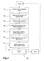
- a query scheme for this procedure is outlined in FIG. 2. This is just one possible example In another method, e.g. a target memory is provided become.
- the current position 8 is first projected onto a corresponding map.
- This step is characterized by reference number 11.
- the start and destination coordinates of the route are selected.
- a navigation device calculates a suitable route, which is indicated in the third step 13.
- the degree of scaling is parameterized. This step, identified by reference numeral 14, gives the possibility of choosing a maximum and a minimum degree of scaling, in the example shown the maximum degree of scaling to 1 and the minimum degree to 0.
- the current position becomes scaling degree 1, that is to say maximum degree of scaling.
- the change in scaling depends on the one hand on the respective x and y value on the projection and on the other hand on the time, provided the current position changes over time.
- a query is made as to whether the target point with the target coordinates x target and y target has already been reached. If this should be the case, the target point tracking and navigation are defined as complete, which is indicated in FIG. 2 by "end". The query is then reset to the starting point. If the target point query is negative, i.e. the target or the target point has not yet been reached, the maximum degree of scaling of the current position will continue to be updated. This is also indicated in Figure 2.
- the representation of the target can be omitted become.
- a selection of distinctive areas can also be defined that are only in the area of minimum resolution or Border areas are shown, such as rivers, forest areas Etc.
- Figure 3 shows three possible mapping rules to represent a relative Scale change depending on the relative distance to the current position.
- Data from one device for projecting navigation data with another Scaling can be represented as the remaining data of the projection, being the scaling between the different data is continuous and / or changed or changeable step by step within the projection is.
- the step size can in particular be set by the user himself be determined or is by corresponding functions in the projection specified or automatically set by this. Part of the data or projection is shown enlarged, whereas the the rest can be shown in normal format or even reduced.
Landscapes
- Engineering & Computer Science (AREA)
- Radar, Positioning & Navigation (AREA)
- Remote Sensing (AREA)
- Automation & Control Theory (AREA)
- Physics & Mathematics (AREA)
- General Physics & Mathematics (AREA)
- Navigation (AREA)
- Instructional Devices (AREA)
Applications Claiming Priority (2)
| Application Number | Priority Date | Filing Date | Title |
|---|---|---|---|
| DE10141507 | 2001-08-24 | ||
| DE2001141507 DE10141507C2 (de) | 2001-08-24 | 2001-08-24 | Vorrichtung zur Projektion von Navigationsdaten |
Publications (2)
| Publication Number | Publication Date |
|---|---|
| EP1288627A2 true EP1288627A2 (fr) | 2003-03-05 |
| EP1288627A3 EP1288627A3 (fr) | 2006-08-23 |
Family
ID=7696479
Family Applications (1)
| Application Number | Title | Priority Date | Filing Date |
|---|---|---|---|
| EP02018439A Withdrawn EP1288627A3 (fr) | 2001-08-24 | 2002-08-16 | Dispositif pour projeter des données de navigation |
Country Status (2)
| Country | Link |
|---|---|
| EP (1) | EP1288627A3 (fr) |
| DE (1) | DE10141507C2 (fr) |
Cited By (15)
| Publication number | Priority date | Publication date | Assignee | Title |
|---|---|---|---|---|
| EP1643214A2 (fr) * | 2004-10-01 | 2006-04-05 | Bose Corporation | Système de navigation pour véhicule et procédé d'affichage d'informations correspondants |
| WO2006117021A1 (fr) * | 2005-04-29 | 2006-11-09 | Volkswagen Ag | Procede pour piloter la visualisation d'une carte geographique dans un vehicule et dispositif de visualisation a cet effet |
| WO2007110690A1 (fr) * | 2006-03-27 | 2007-10-04 | Sony Ericsson Mobile Communications Ab | Affichage basé sur des informations de localisation |
| EP1901038A1 (fr) * | 2006-09-12 | 2008-03-19 | Alpine Electronics, Inc. | Système d'affichage des cartes et système de navigation |
| CN1841022B (zh) * | 2005-03-30 | 2011-09-21 | 株式会社电装 | 导航系统 |
| EP2700906A1 (fr) * | 2012-08-23 | 2014-02-26 | Harman Becker Automotive Systems GmbH | Procédé permettant d'afficher des vues cartographiques et système de visualisation cartographique |
| CN103971587A (zh) * | 2013-02-05 | 2014-08-06 | 昆达电脑科技(昆山)有限公司 | 导航用渐层地图、其产生方法及导航装置 |
| EP3111403A4 (fr) * | 2014-02-26 | 2017-11-01 | Blazer and Flip Flops Inc. D/B/A The Experience Engine Inc. | Gestion de carte dynamique avec marquage en direct |
| US10028091B2 (en) | 2015-04-23 | 2018-07-17 | Blazer and Flip Flops, Inc. | Targeted venue message distribution |
| US10129728B2 (en) | 2015-12-07 | 2018-11-13 | Blazer and Flip Flops, Inc. | Wearable device |
| US10149103B2 (en) | 2015-05-01 | 2018-12-04 | Blazer and Flip Flops, Inc. | Map based beacon management |
| US10198717B2 (en) | 2014-02-26 | 2019-02-05 | Blazer and Flip Flops, Inc. | Parental controls |
| US10210542B2 (en) | 2014-02-26 | 2019-02-19 | Blazer and Flip Flops, Inc. | Venue guest device message prioritization |
| CN114072865A (zh) * | 2019-04-18 | 2022-02-18 | 索尼半导体解决方案公司 | 信息处理装置、移动装置、方法和程序 |
| US11526916B2 (en) | 2015-04-28 | 2022-12-13 | Blazer and Flip Flops, Inc. | Intelligent prediction of queue wait times |
Families Citing this family (1)
| Publication number | Priority date | Publication date | Assignee | Title |
|---|---|---|---|---|
| DE102015005687A1 (de) * | 2015-05-06 | 2016-11-10 | Iav Gmbh Ingenieurgesellschaft Auto Und Verkehr | Kontinuierliche Kartenprojektion mit variabler Detaildarstellung |
Citations (5)
| Publication number | Priority date | Publication date | Assignee | Title |
|---|---|---|---|---|
| JPH0261690A (ja) * | 1988-08-26 | 1990-03-01 | Daihatsu Motor Co Ltd | ナビゲーション用地図の表示方法 |
| JPH06273184A (ja) * | 1993-03-23 | 1994-09-30 | Nissan Motor Co Ltd | 車両用経路誘導装置の表示方法 |
| DE19537255A1 (de) * | 1994-10-15 | 1996-04-18 | Volkswagen Ag | Navigationsgerät |
| EP0793074A1 (fr) * | 1996-03-02 | 1997-09-03 | Philips Patentverwaltung GmbH | Méthode et dispositif pour la représentation d'une carte géographique |
| US5699255A (en) * | 1995-10-18 | 1997-12-16 | Trimble Navigation Limited | Map transmission for in-vehicle navigation system with dynamic scale/detail adjustment |
Family Cites Families (8)
| Publication number | Priority date | Publication date | Assignee | Title |
|---|---|---|---|---|
| JPH0261590A (ja) * | 1988-08-26 | 1990-03-01 | Seiko Epson Corp | 時計用文字板の足及び足の溶接方法 |
| DE4121095B4 (de) * | 1991-06-26 | 2004-09-16 | Robert Bosch Gmbh | Verfahren zur Darstellung von Landkarten auf einem rechnergesteuerten Bildschirm |
| JPH06137882A (ja) * | 1992-10-28 | 1994-05-20 | Toyota Motor Corp | 車両用経路誘導装置 |
| EP0678731B1 (fr) * | 1994-04-15 | 1999-06-30 | Nissan Motor Co., Ltd. | Système de navigation pour véhicule |
| US5742924A (en) * | 1994-12-02 | 1998-04-21 | Nissan Motor Co., Ltd. | Apparatus and method for navigating mobile body using road map displayed in form of bird's eye view |
| JP3781795B2 (ja) * | 1995-01-20 | 2006-05-31 | 三菱電機株式会社 | 移動体用ナビゲーション装置 |
| JPH08339162A (ja) * | 1995-06-12 | 1996-12-24 | Alpine Electron Inc | 地図描画方法 |
| JP3492145B2 (ja) * | 1997-04-28 | 2004-02-03 | パイオニア株式会社 | 地図表示制御方法及び装置並びに地図表示制御用プログラムを記録した記録媒体 |
-
2001
- 2001-08-24 DE DE2001141507 patent/DE10141507C2/de not_active Expired - Lifetime
-
2002
- 2002-08-16 EP EP02018439A patent/EP1288627A3/fr not_active Withdrawn
Patent Citations (5)
| Publication number | Priority date | Publication date | Assignee | Title |
|---|---|---|---|---|
| JPH0261690A (ja) * | 1988-08-26 | 1990-03-01 | Daihatsu Motor Co Ltd | ナビゲーション用地図の表示方法 |
| JPH06273184A (ja) * | 1993-03-23 | 1994-09-30 | Nissan Motor Co Ltd | 車両用経路誘導装置の表示方法 |
| DE19537255A1 (de) * | 1994-10-15 | 1996-04-18 | Volkswagen Ag | Navigationsgerät |
| US5699255A (en) * | 1995-10-18 | 1997-12-16 | Trimble Navigation Limited | Map transmission for in-vehicle navigation system with dynamic scale/detail adjustment |
| EP0793074A1 (fr) * | 1996-03-02 | 1997-09-03 | Philips Patentverwaltung GmbH | Méthode et dispositif pour la représentation d'une carte géographique |
Non-Patent Citations (2)
| Title |
|---|
| PATENT ABSTRACTS OF JAPAN Bd. 014, Nr. 240 (P-1051), 22. Mai 1990 (1990-05-22) & JP 02 061690 A (DAIHATSU MOTOR CO LTD), 1. März 1990 (1990-03-01) * |
| PATENT ABSTRACTS OF JAPAN Bd. 018, Nr. 685 (P-1848), 22. Dezember 1994 (1994-12-22) & JP 06 273184 A (NISSAN MOTOR CO LTD), 30. September 1994 (1994-09-30) * |
Cited By (20)
| Publication number | Priority date | Publication date | Assignee | Title |
|---|---|---|---|---|
| EP1643214A2 (fr) * | 2004-10-01 | 2006-04-05 | Bose Corporation | Système de navigation pour véhicule et procédé d'affichage d'informations correspondants |
| EP1643214A3 (fr) * | 2004-10-01 | 2006-12-27 | Bose Corporation | Système de navigation pour véhicule et procédé d'affichage d'informations correspondants |
| US7430473B2 (en) | 2004-10-01 | 2008-09-30 | Bose Corporation | Vehicle navigation display |
| CN1841022B (zh) * | 2005-03-30 | 2011-09-21 | 株式会社电装 | 导航系统 |
| WO2006117021A1 (fr) * | 2005-04-29 | 2006-11-09 | Volkswagen Ag | Procede pour piloter la visualisation d'une carte geographique dans un vehicule et dispositif de visualisation a cet effet |
| US8095307B2 (en) | 2005-04-29 | 2012-01-10 | Volkswagen Ag | Method for controlling the display of a geographical map in a vehicle and display apparatus for that purpose |
| WO2007110690A1 (fr) * | 2006-03-27 | 2007-10-04 | Sony Ericsson Mobile Communications Ab | Affichage basé sur des informations de localisation |
| US7548814B2 (en) | 2006-03-27 | 2009-06-16 | Sony Ericsson Mobile Communications Ab | Display based on location information |
| EP1901038A1 (fr) * | 2006-09-12 | 2008-03-19 | Alpine Electronics, Inc. | Système d'affichage des cartes et système de navigation |
| EP2700906A1 (fr) * | 2012-08-23 | 2014-02-26 | Harman Becker Automotive Systems GmbH | Procédé permettant d'afficher des vues cartographiques et système de visualisation cartographique |
| CN103971587A (zh) * | 2013-02-05 | 2014-08-06 | 昆达电脑科技(昆山)有限公司 | 导航用渐层地图、其产生方法及导航装置 |
| EP3111403A4 (fr) * | 2014-02-26 | 2017-11-01 | Blazer and Flip Flops Inc. D/B/A The Experience Engine Inc. | Gestion de carte dynamique avec marquage en direct |
| US10198717B2 (en) | 2014-02-26 | 2019-02-05 | Blazer and Flip Flops, Inc. | Parental controls |
| US10210542B2 (en) | 2014-02-26 | 2019-02-19 | Blazer and Flip Flops, Inc. | Venue guest device message prioritization |
| US10028091B2 (en) | 2015-04-23 | 2018-07-17 | Blazer and Flip Flops, Inc. | Targeted venue message distribution |
| US10299070B2 (en) | 2015-04-23 | 2019-05-21 | Blazer and Flip Flops, Inc. | Targeted venue message distribution |
| US11526916B2 (en) | 2015-04-28 | 2022-12-13 | Blazer and Flip Flops, Inc. | Intelligent prediction of queue wait times |
| US10149103B2 (en) | 2015-05-01 | 2018-12-04 | Blazer and Flip Flops, Inc. | Map based beacon management |
| US10129728B2 (en) | 2015-12-07 | 2018-11-13 | Blazer and Flip Flops, Inc. | Wearable device |
| CN114072865A (zh) * | 2019-04-18 | 2022-02-18 | 索尼半导体解决方案公司 | 信息处理装置、移动装置、方法和程序 |
Also Published As
| Publication number | Publication date |
|---|---|
| DE10141507A1 (de) | 2003-03-13 |
| EP1288627A3 (fr) | 2006-08-23 |
| DE10141507C2 (de) | 2003-06-18 |
Similar Documents
| Publication | Publication Date | Title |
|---|---|---|
| EP2026038B1 (fr) | Procédé pour changer l'échelle de la représentation d'une carte dans un système de navigation | |
| DE3842179C2 (fr) | ||
| EP1877731B1 (fr) | Procede pour piloter la visualisation d'une carte geographique dans un vehicule et dispositif de visualisation a cet effet | |
| DE69928387T2 (de) | Dreidimensionale strassenkreutzungsanzeige für ein fahrzeugnavigationssystem | |
| DE4219326C2 (de) | Verkehrsinformationsanzeigesystem | |
| DE112004001405B4 (de) | Kartenanzeigeverfahren | |
| DE69531188T2 (de) | Navigationsvorrichtung | |
| DE69633421T2 (de) | Navigationsanzeige mit Vogelperspektive | |
| DE69434693T2 (de) | Fahrzeugzielführungsvorrichtung und -verfahren unter Verwendung einer Anzeigeeinheit | |
| EP1288627A2 (fr) | Dispositif pour projeter des données de navigation | |
| DE112004001569T5 (de) | Fahrzeuginternes Informationsendgerät | |
| EP0942403B1 (fr) | Méthode et dispositif pour la représentation d'informations pour un appareil de navigation | |
| DE19636056A1 (de) | Navigationsgerät | |
| DE10023160A1 (de) | Kartenanzeigevorrichtung | |
| DE60132946T2 (de) | Navigationssystem | |
| EP3365632B1 (fr) | Procédé de représentation imagée modifiée des lieux de points de destination sélectionnés sur des cartes | |
| DE4405771C2 (de) | Navigationssystem mit einem Routenbestimmungsverfahren zum schnellen und genauen Bestimmen einer gewünschten Route | |
| EP1957939B1 (fr) | Dispositif et procede de fourniture d'informations de guidage vers une destination dans un systeme de navigation | |
| DE102008061981A1 (de) | Navigationsgerät | |
| DE19738764A1 (de) | Vorrichtung zur graphischen Darstellung einer vorausliegenden Straße | |
| DE10313223A1 (de) | Navigationsgerät zur Zielführung eines Kraftfahrzeugs | |
| DE19839798A1 (de) | Fahrzeugnavigationssystem | |
| EP1890112B1 (fr) | Procédé destiné à l'affichage d'informations concernant des objets et système de navigation correspondant | |
| DE19839204A1 (de) | Kartenanzeigevorrichtung | |
| DE19531824A1 (de) | Verfahren zur Ansteuerung einer Anzeigevorrichtung zur Zielführung eines Fahrzeugs |
Legal Events
| Date | Code | Title | Description |
|---|---|---|---|
| PUAI | Public reference made under article 153(3) epc to a published international application that has entered the european phase |
Free format text: ORIGINAL CODE: 0009012 |
|
| AK | Designated contracting states |
Kind code of ref document: A2 Designated state(s): AT BE BG CH CY CZ DE DK EE ES FI FR GB GR IE IT LI LU MC NL PT SE SK TR Designated state(s): AT BE BG CH CY CZ DE DK EE ES FI FR GB GR IE IT LI LU MC NL PT SE SK TR |
|
| AX | Request for extension of the european patent |
Extension state: AL LT LV MK RO SI |
|
| PUAL | Search report despatched |
Free format text: ORIGINAL CODE: 0009013 |
|
| AK | Designated contracting states |
Kind code of ref document: A3 Designated state(s): AT BE BG CH CY CZ DE DK EE ES FI FR GB GR IE IT LI LU MC NL PT SE SK TR |
|
| AX | Request for extension of the european patent |
Extension state: AL LT LV MK RO SI |
|
| STAA | Information on the status of an ep patent application or granted ep patent |
Free format text: STATUS: THE APPLICATION HAS BEEN WITHDRAWN |
|
| 18W | Application withdrawn |
Effective date: 20060829 |