EP0346492B1 - Procede de recherche de route pour systeme indicateur de route - Google Patents
Procede de recherche de route pour systeme indicateur de route Download PDFInfo
- Publication number
- EP0346492B1 EP0346492B1 EP89900884A EP89900884A EP0346492B1 EP 0346492 B1 EP0346492 B1 EP 0346492B1 EP 89900884 A EP89900884 A EP 89900884A EP 89900884 A EP89900884 A EP 89900884A EP 0346492 B1 EP0346492 B1 EP 0346492B1
- Authority
- EP
- European Patent Office
- Prior art keywords
- data
- road
- block
- intersection
- route
- Prior art date
- Legal status (The legal status is an assumption and is not a legal conclusion. Google has not performed a legal analysis and makes no representation as to the accuracy of the status listed.)
- Expired - Lifetime
Links
Images


Classifications
-
- G—PHYSICS
- G08—SIGNALLING
- G08G—TRAFFIC CONTROL SYSTEMS
- G08G1/00—Traffic control systems for road vehicles
- G08G1/09—Arrangements for giving variable traffic instructions
- G08G1/0962—Arrangements for giving variable traffic instructions having an indicator mounted inside the vehicle, e.g. giving voice messages
- G08G1/0968—Systems involving transmission of navigation instructions to the vehicle
- G08G1/096805—Systems involving transmission of navigation instructions to the vehicle where the transmitted instructions are used to compute a route
- G08G1/096827—Systems involving transmission of navigation instructions to the vehicle where the transmitted instructions are used to compute a route where the route is computed onboard
-
- G—PHYSICS
- G01—MEASURING; TESTING
- G01C—MEASURING DISTANCES, LEVELS OR BEARINGS; SURVEYING; NAVIGATION; GYROSCOPIC INSTRUMENTS; PHOTOGRAMMETRY OR VIDEOGRAMMETRY
- G01C21/00—Navigation; Navigational instruments not provided for in groups G01C1/00 - G01C19/00
- G01C21/26—Navigation; Navigational instruments not provided for in groups G01C1/00 - G01C19/00 specially adapted for navigation in a road network
- G01C21/34—Route searching; Route guidance
- G01C21/3446—Details of route searching algorithms, e.g. Dijkstra, A*, arc-flags, using precalculated routes
-
- G—PHYSICS
- G08—SIGNALLING
- G08G—TRAFFIC CONTROL SYSTEMS
- G08G1/00—Traffic control systems for road vehicles
- G08G1/09—Arrangements for giving variable traffic instructions
- G08G1/0962—Arrangements for giving variable traffic instructions having an indicator mounted inside the vehicle, e.g. giving voice messages
- G08G1/0968—Systems involving transmission of navigation instructions to the vehicle
- G08G1/0969—Systems involving transmission of navigation instructions to the vehicle having a display in the form of a map
Definitions
- This invention relates to a route navigation apparatus which searches for the shortest route from a point of departure to a destination. More particularly, the invention relates to a route exploration method of a navigation apparatus which searches for a route by putting map data into a heirarchical structure.
- a navigation apparatus provides route guidance for travel to a destination to a driver who is unfamiliar with the local geography. Recent years have seen extensive development of such navigation apparatus.
- the conventional navigation apparatus is adapted to set a route from a point of departure to a desired destination by being provided with an input of point of departure and destination prior to travel, and to perform navigation in accordance with the route set.
- a route is designated
- navigation is such that a map is displayed on the screen of a CRT and the route is superimposed on the map.
- distance to an intersection at which a turn is to be made next is displayed numerically, in the form of a graph or as a characteristic photograph as information relating to the intersection at which the next turn is to be made in accordance with the preset route.
- a voice-track output is also used in some of these apparatus.
- a road network usually possesses a plurality of routes from a point of departure to a destination. Accordingly, attempts have been made to employ a route exploration method in a navigation apparatus in which, when the apparatus is provided with inputs of departure point and destination, a route (referred to as the "shortest route") representing the shortest path between these two points in terms of time or distance is retrieved.
- a route (referred to as the "shortest route") representing the shortest path between these two points in terms of time or distance is retrieved.
- the intersection in order to express left and right turns, movement straight ahead and a U-turn in case of an intersection where four roads cross, the intersection is represented by eight nodes and 16 directional links, and branch roads interconnecting intersections are represented by two directional links.
- the shortest route once retrieved is compared with courses along which travel is prohibited, and shortest routes which include these prohibited routes are excluded, whereby there is retrieved a shortest route which does not include a prohibited route.
- left-right turn information at an intersection is expressed entirely in terms of directional links, there is a large quantity of data and, hence, a large storage capacity is required.
- the conventional data structure is such that when it is attempted to retrieve a route which is the shortest in terms of time by detecting a left or right turn and applying weighting depending upon a left or right turn, the computations for judging left and right turns are complicated and time- consuming.
- four intersecting roads are expressed by eight nodes and 16 directional links, distance or time data applied as weighting to the 16 directional links must be provided. As a consequence, the amount of data is increased.
- route exploration is such that there is a correspondingly large number of intersections which may be the object of retrieval. Consequently, there is an increase in computation time required for route exploration and an increase in storage capacity required of the memory used when performing exploration processing.
- WO-A-88/09974 relates to a method for determining a road between a starting point and a destination point.
- a street network is divided and recorded into at least two levels of mesh densities and original sizes.
- a detailed route exploration is performed after a level is achieved which shows a possible route between the starting and the destination point.
- EP-A2-0 246 452 relates to a navigation method wherein a departure and a destination point are set. A route exploration is performed in two areas with the same road density, i.e. in layers of the same order.
- An object of the present invention is to reduce the quantity of stored data and make possible high-speed route exploration inclusive of decisions regarding data related to prohibited left and right turns. Another object of the invention is to shorten the time needed for route exploration computations.
- the present invention provides a route exploration method as defined in independent claim 1.
- the method as in a navigation apparatus for setting a route from a designated departure point to a destination and providing guidance along the route involves providing, as map data used in route exploration, node data comprising position information and informatation relating to the attributes thereof, intersection data comprising information relating to intersections, and road data comprising information related to roads, and retrieving an optimum route from the intersection data and road data.
- Further steps include putting map data into a layered structure, developing a branch road network connected to a trunk road network with respect to a higher-order layer of the trunk road network and performing block division, and successively repeating exploration from a lower-order layer to intersections connected to a road network of the higher-order layer, and retrieving a route from the departure point to the destination.
- connection information relating to roads between intersections for every block of each layer, and connecting-intersection information for connection to the higher-order layer is used, while, increasing the number of divided blocks of the lower-order layer in conformity with the amount of information, and rising to a higher-order layer, while repeating exploration from the lower-order layer, until a departure-point block and a destination block become the same block or neighboring blocks.
- left-right turn prohibition information and route conversion information may be set, e.g. information relating to guidance not required and degree of difficulty to pass through a road, excluding from retrieved courses, at the time of route retrieval, roads for which left-right turn prohibition information has been set, and retrieving an optimum route upon attaching route conversion information.
- route exploration is carried out in the block of this layer. If there is no intersection number in the higher-order layer, route exploration from this intersection to an intersection having an intersection number of the higher-order layer is performed and a transition is made to a block of a still higher order layer.
- route exploration from the departure point to the destination is terminated between the blocks.
- route exploration means excludes roads for which the left-right prohibition information has been set from retrieved courses when routes are being retrieved, and an optimum route can be retrieved efficiently using the route conversion information. As a result, wasteful exploration processing is eliminated and processing can be speeded up.
- a layer 1 is a map of a principal trunk road network having intersection numbers I, II, III, ... and so on.
- the layer 1 is composed of a single block 1.
- a layer 2 is a map which also includes a road network of branch lines connected to the principal trunk road network.
- This layer is composed of six blocks 1 - 6. Intersections are set in dummy fashion on connecting roads between blocks, as in the manner of intersection numbers V and II between blocks 1 and 2 of layer 2, in such a manner that processing units can be constituted by blocks.
- the number of blocks is set in such a manner that the amount of information in each is approximately the same. Accordingly, block 1 in layer 1 and blocks 1 - 6 in layer 2 are such that each possesses the same amount of information as road network data.
- the route exploration method of the present invention employs map data of a layered structure comprising layers 1, 2, ... each divided into blocks as the data expand from trunk roads to branch roads in the direction of descending hierarchy. These data are used to search for routes from a point of departure to a destination. Accordingly, in a case where there are branch roads lower in hierarchy than the road network of layer 2, a layer 3 is set and this layer possesses a greater number of blocks in conformity with the amount of information. Similarly, in a case where a peripheral road network is also a subject of exploration, layer 1 need not be composed of only the one block 1 but may be constituted by block 1 and the blocks of the road network peripheral thereto. In such case, a layer higher in hierarchy than layer 1 will be set.
- a point of departure and a destination are an intersection number 1 in block 1 of layer 2 and an intersection number III in block 6 of layer 2, respectively.
- intersection number of this departure point is not in layer 1 of the higher-order layer. Accordingly, the intersection numbers that are in layer 1 of the higher-order layer are found, routes to these intersection numbers III, IV (intersection numbers I, in layer 1) are retrieved and these are raised to the higher-order layer.
- intersection number III in block 6 is intersection number VIII in layer 1 of the higher-order layer. Therefore, this is raised to the higher-order layer as is.
- route exploration from intersection number I or to the intersection number VIII is performed using also the information retrieved in the lower-order layer 2.
- Route exploration in the invention is such that exploration is performed as follows depending upon each case:
- the data in each block unit comprise road data [(a) of these Figures] and intersection data [(b) of these Figures].
- the road data include, in correspondence with each road number of a block, such information as starting-point intersection number, end-point intersection number, road number having the same starting point, road number having the same end point, a road not requiring guidance, relative length of the road, layer, etc.
- the unit of a road number usually comprises a plurality of nodes. Though not shown, node data are data relating to one geographical point on a road.
- intersection data include, in correspondence with the each intersection number in a block, such information as east longitude, north latitude, exiting road number, entering road number, intersection number on a higher layer, intersection number on a lower layer, intersection number of a block alongside (connecting intersection number), etc.
- the road numbers having the same starting points (end points) and the exiting (entering) road numbers constitute information relating to connecting roads at each intersection. Since a plurality of road numbers usually exist, the smallest road number among them is registered. When this is done, retrieval of the connecting roads of an intersection can be performed with ease, as will be set forth later.
- Roads not requiring guidance and the relative lengths of roads constitute information which is required when calculating actual time needed for travel. For example, even if roads have the same width or length, actual travel time can be calculated quicker for roads not requiring guidance than for roads that do require guidance. Even if roads have the same length, relative length can be greater if the travelling conditions are poor or if traffic tie-ups are likely. Layer indicates the rank of a road.
- this is information indicating which layer of what rank possesses a road.
- the intersection number of an upper (lower) layer e.g., 1-1-2, indicates layer 1 - block 1 - intersection number in this layer block. The same is true for an intersection number of a block alongside.
- a work file makes use of intersection data and road data in a block read in when performing exploration in block units.
- the information stored in a work file includes the number of intersections, starting points, end points, the number of roads, the number of roads entering an intersection obtained as a result of exploration processing in a block, and flags indicating departure point and destination in a block.
- An index file is for processing information in a block.
- an index file includes the number of blocks and block numbers.
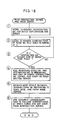
- intersection data and road data are entered, the work area is initialized and departure point and destination are set. Thereafter, processing branches to the route exploration subroutine, where routes retrieved and generated are outputted.
- intersection number is expressed in the form of C (layer - block - intersection number) and road number in the form of R (layer - block - road number), and where departure point is represented by C (2-1-1) and destination by C (2-4-4), processing is performed as follows in accordance with the steps shown in Fig. 9:
- the route exploration subroutine will now be described.
- L(c) represents distance, F(c) aflag, R(c) the number of an intersection through which the vehicle has passed, so, S 1 the numbers of intersections adjacent a departure point on both sides thereof, and e o , e 1 the numbers of intersections adjacent a destination on both sides thereof. Further, c denotes an intersection number.
- the flag F(c) indicates that exploration has not been performed when its value is "0", that exploration is in effect when its value is "1”, and that exploration has ended when its value is "2".
- step 6 If the answer is YES, the program proceeds to the following processing of step 6; if the answer is NO, the program proceeds to the processing of step 11.
- step 10 If the answer is YES, the program proceeds to the following processing of step 10 ; if the answer is NO, the program proceeds to the-processing of step 4.
- a road number of an optimum course from the point of departure to the pertinent intersection number is set for each and every intersection number in correspondence with respective ones of the intersection numbers.
- the peripheral road retrieval subroutine of processing step 4 is for executing the processing shown in Fig. 12. Specifically, the processing is as follows:
- step 2 If the answer is YES, the program proceeds to the processing of step 2; if the answer is NO, the program proceeds to the processing of step 6.
- step 6 If the answer is YES, the program proceeds to the processing of step 6; if the answer is NO, the program proceeds to the processing of step 5.
- step 8 If the answer is YES, the program proceeds to the processing of step 8; if the answer is NO, the program proceeds to the processing of step 3. (8) It is decided that there are no peripheral roads and the program returns.
- the optimum route condition setting subroutine of processing step 4 shown in Fig. 11 is for executing the processing shown in Fig. 13. Specifically, the processing is as follows:
- intersection data will have the data configuration shown in (b) of Fig. 15, the road data will have the data configuration shown in (c), and the node data will have the data configuration shown in (d) in a case where a road network comprises, e.g., intersection numbers I - IV and road numbers 1 - 8 as shown in Fig. 15(a).
- the intersection data comprises intersection names corresponding to the intersections numbers I - IV, road numbers having the smallest numbers among those roads possessing a certain intersection as a starting point, road numbers having the smallest numbers among those roads possessing a certain intersection as an end point, and information indicating whether or not a certain intersection has a traffic signal.
- the road data comprises starting and end points, in the form of intersection numbers, of the road numbers 1 through 8, the numbers of roads having the same starting point, the numbers of roads having the same end point, road width, information relating to prohibitions, information relating to guidance not required, photograph numbers, the numbers of nodes, the leading addresses of node series data, length, etc.
- the node array data comprises information relating to east longitude, north latitude, attributes and the like.
- the units of the road numbers comprise a plurality of nodes, as is evident from the road data. More specifically, the node data is data relating to one point on a road. If a line connecting nodes is referred to as an arc, a road is expressed by connecting each of a plurality of node arrays by arcs. For example, with regard to road number 1, the road comprises 15 nodes and the leading address of the node array data is 100, based on the road data. Therefore, road number G) is composed of node data having addresses 100 to 114.
- intersection number for example.
- first road number 1 is retrieved from the starting point information of the intersection point data
- road number 7 is retrieved from the road data relating to the road number (d), namely from the column reading "NO. OF ROAD HAVING SAME STARTING POINT". Since the same information for road number 7 will, in converse fashion, lead to retrieval of road number (d), it can be determined that there are no other road numbers available as peripheral roads. The same will hold true with regard to end points.
- road number 4 will be prohibited in case of road number 5 ⁇ in the road data, the vehicle will not be able to enter road number 4 from road number 5 at the intersection number IV shown in Fig. 15(a) because turns are prohibited at this intersection.
- the only road that can be entered is the road number 8 Accordingly, guidance to road number 8 is unnecessary.
- the road data in particular possesses the numbers of roads which are forbidden to enter, such as left-right turn prohibitions, as well as the numbers of roads for which guidance is not required, information storage capacity can be reduced and path exploration can be carried out with ease.
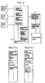
- numeral 1 denotes intersection data, 2 road data, 3 node data, 4 a route exploration processor, 5 an intersection series and node series generator, 6 intersection series and node series data, and 7 a navigation unit.
- the route exploration processor 4 executes the processing shown in Fig. 7. This processing includes an identical-block exploration processing routine, an adjacent-block exploration processing routine, a remote-block exploration processing routine and an exploration subroutine, which were described earlier.
- a peripheral-road retrieval subroutine for retrieving peripheral roads from an intersection with the exception of roads into which entry is forbidden, such as roads where left-right turns are prohibited
- an optimum route condition setting subroutine for setting conditions necessary to compute an optimum route, such as road width and whether or not guidance is required
- an end-condition verifying routine for judging the end of route exploration.
- These subroutines are for retrieving the optimum road from a designated point of departure to a destination.
- the intersection series and node series generator 5 When an optimum route is explored by the route exploration processor 4, the intersection series and node series generator 5 generates intersection series data and node series data, of the kind shown in Fig. 17, along the route, and the navigation unit 7 performs navigation based on these intersection series and node series data.
- the navigation unit 7 has data processing means and display or voice output means and is adapted to read out the intersection series data and node series data 6 at a predetermined geographical point along a course and provide course guidance by a display output or voice output.
- intersection series and node series data can be generated in accordance with the processing flow shown in Fig. 18.
- Fig. 17 illustrates an example of the intersection series and node series data thus generated from the results of route exploration.
- the intersection series data comprises such information as intersection name, intersection number, the number of a photograph showing the characteristic scenery of an intersection, the angle of a turn and distance.
- the node series data comprises such information as east longitude and north latitude representing node position, the intersection number, attribute, angle and distance.
- these data comprise data indicative solely of intersections requiring guidance; in other words, intersections not requiring guidance are excluded. In navigation, therefore, it will suffice to successively read out and output data in correspondence with a predetermined position.
- exploration may be performed while checking left-right turn prohibition data, and a course is retrieved that does not include left-right turn prohibitions.
- the shortest route is retrieved by applying weighting to the distance between intersections based on route conversion information, such as the degree of difficulty in traversing a route, upon taking into consideration such travelling conditions as the size of peripheral roads and whether or not a road requires guidance.
- the present invention is not limited to the foregoing embodiment but can be modified in various ways.
- exploration is performed while rising to a higher-order layer until point of depature and destination fall in the same block or mutually adjacent blocks.
- this route can no longer be set. Accordingly, in the case of mutually adjacent blocks, it is more efficient to terminate route exploration in this layer.
- route exploration was started from a point of departure, it can be arranged for course exploration to start from a destination. Further, though processing was terminated when the destination was reached upon starting route exploration from the point of departure, it can be arranged to perform course exploration until all flags F(c) become 2, namely with regard to all intersections. In particular, when this course exploration is performed from the destination, optimum course information from all intersections to the destination is created. Therefore, even in a case where the system strays off course in mid stream, intersection series and node series data can be created from the nearest intersection.
- road network data such as intersection data and road data are possessed in the form of a heirarchical structure, and exploration is performed by successively rising from lower-order to higher-order layers.
- block division is carried out in dependence upon the amount of data in each layer and exploration is executed in block units. As a result, the working area needed for exploration can be reduced and storage area can be conserved.
- Intersection data, road data and node series data are stored in memory means such as a CD-ROM in advance, these data are read out to a RAM or the like before route exploration, and route exploration is performed while checking for right-left turn prohibitions. Since the right-left turn prohibition data are possessed in a form contained in the road data, the amount of data can be reduced and so can be required storage capacity. Furthermore, since guidance-unnecessary data are provided and whether to travel straight ahead or turn left or right is decided based on these data, exploration for the shortest route in terms of time can be executed with a small amount of data.
- intersections at which the vehicle travels straight ahead are verified from the guidance-unnecessary data and excluded from the intersection series, and use is made of data indicative solely of intersections at which a left or right turn is made. This is carried out through simple processing.
Abstract
Claims (2)
Applications Claiming Priority (5)
| Application Number | Priority Date | Filing Date | Title |
|---|---|---|---|
| JP62333038A JP2641470B2 (ja) | 1987-12-28 | 1987-12-28 | ナビゲーション装置 |
| JP333038/87 | 1987-12-28 | ||
| JP207762/88 | 1988-08-22 | ||
| JP20776288A JP2653847B2 (ja) | 1988-08-22 | 1988-08-22 | ナビゲーション装置及びそのルート探索方法 |
| PCT/JP1988/001301 WO1989006414A1 (fr) | 1987-12-28 | 1988-12-23 | Procede de recherche de route pour systeme indicateur de route |
Publications (3)
| Publication Number | Publication Date |
|---|---|
| EP0346492A1 EP0346492A1 (fr) | 1989-12-20 |
| EP0346492A4 EP0346492A4 (en) | 1991-11-13 |
| EP0346492B1 true EP0346492B1 (fr) | 1995-05-03 |
Family
ID=26516451
Family Applications (1)
| Application Number | Title | Priority Date | Filing Date |
|---|---|---|---|
| EP89900884A Expired - Lifetime EP0346492B1 (fr) | 1987-12-28 | 1988-12-23 | Procede de recherche de route pour systeme indicateur de route |
Country Status (4)
| Country | Link |
|---|---|
| US (1) | US5168452A (fr) |
| EP (1) | EP0346492B1 (fr) |
| DE (1) | DE3853719T2 (fr) |
| WO (1) | WO1989006414A1 (fr) |
Families Citing this family (107)
| Publication number | Priority date | Publication date | Assignee | Title |
|---|---|---|---|---|
| US5504683A (en) * | 1989-11-21 | 1996-04-02 | Gurmu; Hailemichael | Traffic management system |
| US5036471A (en) * | 1989-04-18 | 1991-07-30 | Sanyo Electric Co., Ltd. | Apparatus for road path searching applicable to car navigation system and operation method thereof |
| FR2667423B1 (fr) * | 1990-09-28 | 1995-05-24 | Sagem | Recepteur de bord d'aide a la navigation automobile. |
| JPH04187851A (ja) * | 1990-11-20 | 1992-07-06 | Toyota Motor Corp | 筒内直接噴射式火花点火機関 |
| JPH04188181A (ja) * | 1990-11-22 | 1992-07-06 | Nissan Motor Co Ltd | 車両用経路検索装置 |
| JP2874397B2 (ja) * | 1991-03-19 | 1999-03-24 | 松下電器産業株式会社 | 経路選出装置 |
| JP3295892B2 (ja) * | 1991-06-13 | 2002-06-24 | 三菱電機株式会社 | 交通情報提示装置 |
| JP2955073B2 (ja) * | 1991-08-05 | 1999-10-04 | ビステオン・テクノロジーズ,エル・エル・シー | 車両用ナビゲーションシステム |
| US5285391A (en) * | 1991-08-05 | 1994-02-08 | Motorola, Inc. | Multiple layer road memory storage device and route planning system |
| US10361802B1 (en) | 1999-02-01 | 2019-07-23 | Blanding Hovenweep, Llc | Adaptive pattern recognition based control system and method |
| US8352400B2 (en) | 1991-12-23 | 2013-01-08 | Hoffberg Steven M | Adaptive pattern recognition based controller apparatus and method and human-factored interface therefore |
| US5303159A (en) * | 1992-04-14 | 1994-04-12 | Zexel Corporation Daihatsu-Nissan | Navigation system with off-route detection and route recalculation |
| JP2983111B2 (ja) * | 1992-07-20 | 1999-11-29 | 富士通株式会社 | 電気機器装置 |
| JPH0634384A (ja) * | 1992-07-16 | 1994-02-08 | Zexel Corp | 車両用ナビゲーション装置 |
| JP2598857B2 (ja) * | 1992-10-12 | 1997-04-09 | マスプロ電工株式会社 | 車両の走行経路設定装置 |
| US5430653A (en) * | 1992-10-12 | 1995-07-04 | Masprodenkoh Kabushikikaisha | Navigation system with route determination process capable of determining a desired route readily and quickly |
| JP2834952B2 (ja) * | 1992-10-22 | 1998-12-14 | アルパイン株式会社 | 経路探索方法 |
| JP2603789B2 (ja) * | 1992-11-16 | 1997-04-23 | マスプロ電工株式会社 | 車両の走行経路誘導装置 |
| US5398189A (en) * | 1992-11-16 | 1995-03-14 | Masprodenkoh Kabushikikaisha | Navigation system for motor vehicles |
| FR2699311B1 (fr) * | 1992-12-11 | 1995-03-03 | Peugeot | Procédé et dispositif de calcul d'un itinéraire de navigation notamment d'un véhicule automobile dans une zone géographique donnée. |
| JP2556650B2 (ja) * | 1993-03-31 | 1996-11-20 | マスプロ電工株式会社 | 車両の走行経路設定装置 |
| JP3027899B2 (ja) * | 1993-05-12 | 2000-04-04 | 松下電器産業株式会社 | 推奨経路案内装置 |
| JP3203399B2 (ja) * | 1993-05-13 | 2001-08-27 | 松下電器産業株式会社 | 経路探索装置 |
| US6282489B1 (en) | 1993-05-28 | 2001-08-28 | Mapquest.Com, Inc. | Methods and apparatus for displaying a travel route and generating a list of places of interest located near the travel route |
| JPH0727568A (ja) * | 1993-07-09 | 1995-01-27 | Zanabui Informatics:Kk | 経路誘導装置および経路探索方法 |
| US5519619A (en) * | 1994-03-14 | 1996-05-21 | Motorola, Inc. | Route planning method for hierarchical map routing and apparatus therefor |
| EP0702208B1 (fr) * | 1994-09-08 | 2002-05-29 | Matsushita Electric Industrial Co., Ltd. | Méthode et sytème pour sélection de route |
| DE69529871T2 (de) * | 1994-09-20 | 2003-11-20 | Aisin Aw Co | Fahrzeugnavigationssystem |
| US5982301A (en) * | 1995-01-20 | 1999-11-09 | Mitsubishi Denki Kabushiki Kaisha | Navigation apparatus |
| JP3247274B2 (ja) * | 1995-02-28 | 2002-01-15 | 松下電器産業株式会社 | 輸送経路探索装置 |
| US5911773A (en) * | 1995-07-24 | 1999-06-15 | Aisin Aw Co., Ltd. | Navigation system for vehicles |
| JP2765814B2 (ja) * | 1995-11-24 | 1998-06-18 | コナミ株式会社 | ビデオゲーム装置及びビデオゲームのプレイキャラクタ成長制御方法 |
| JP3173983B2 (ja) * | 1995-12-28 | 2001-06-04 | 松下電器産業株式会社 | 経路選出方法およびシステム |
| FR2743655B1 (fr) * | 1996-01-16 | 1998-02-13 | Renault | Procede et dispositif de guidage d'un vehicule routier |
| DE69632242T2 (de) * | 1996-02-01 | 2005-04-14 | Aisin AW Co., Ltd., Anjo | Fahrzeugnavigationssystem und Verfahren zur Eingabe und Speicherung von Kursänderungspunkten |
| JP3223782B2 (ja) * | 1996-02-08 | 2001-10-29 | 三菱電機株式会社 | 車両経路算出装置 |
| JP3399779B2 (ja) * | 1996-05-16 | 2003-04-21 | 松下電器産業株式会社 | 道路地図情報の読み出し装置および記録媒体並びに伝送方法 |
| EP0807803B1 (fr) * | 1996-05-16 | 2005-02-23 | Matsushita Electric Industrial Co., Ltd. | Appareil pour la reproduction d'information de cartes routières, support d'enregistrement et méthode de transmission |
| KR100269070B1 (ko) * | 1996-08-30 | 2000-10-16 | 모리 하루오 | 차량용네비게이션장치 |
| JP3477329B2 (ja) * | 1996-10-22 | 2003-12-10 | 株式会社ザナヴィ・インフォマティクス | ナビゲーション装置 |
| US5953722A (en) * | 1996-10-25 | 1999-09-14 | Navigation Technologies Corporation | Method and system for forming and using geographic data |
| US5968109A (en) * | 1996-10-25 | 1999-10-19 | Navigation Technologies Corporation | System and method for use and storage of geographic data on physical media |
| US5974419A (en) * | 1996-10-25 | 1999-10-26 | Navigation Technologies Corporation | Parcelization of geographic data for storage and use in a navigation application |
| US7197500B1 (en) | 1996-10-25 | 2007-03-27 | Navteq North America, Llc | System and method for use and storage of geographic data on physical media |
| US6047280A (en) | 1996-10-25 | 2000-04-04 | Navigation Technologies Corporation | Interface layer for navigation system |
| JP3876463B2 (ja) * | 1996-11-18 | 2007-01-31 | ソニー株式会社 | 地図情報提供装置及び方法 |
| FR2765992B1 (fr) * | 1997-07-11 | 1999-08-20 | Renault | Procede de guidage d'un vehicule sur le reseau routier |
| US7268700B1 (en) | 1998-01-27 | 2007-09-11 | Hoffberg Steven M | Mobile communication device |
| US6016485A (en) * | 1998-02-13 | 2000-01-18 | Etak, Inc. | System for pathfinding |
| US6038559A (en) * | 1998-03-16 | 2000-03-14 | Navigation Technologies Corporation | Segment aggregation in a geographic database and methods for use thereof in a navigation application |
| US6112200A (en) * | 1998-03-16 | 2000-08-29 | Navigation Technologies Corporation | Interleaving of data types in a geographic database and methods for application |
| US6473770B1 (en) | 1998-03-16 | 2002-10-29 | Navigation Technologies Corp. | Segment aggregation and interleaving of data types in a geographic database and methods for use thereof in a navigation application |
| US6192314B1 (en) * | 1998-03-25 | 2001-02-20 | Navigation Technologies Corp. | Method and system for route calculation in a navigation application |
| US7904187B2 (en) | 1999-02-01 | 2011-03-08 | Hoffberg Steven M | Internet appliance system and method |
| JP3455153B2 (ja) | 2000-02-16 | 2003-10-14 | 松下電器産業株式会社 | 交差点における車線誘導案内表示方法およびそのナビゲーション装置並びに記録媒体 |
| JP3475142B2 (ja) * | 2000-03-01 | 2003-12-08 | 三菱電機株式会社 | 地図データ送信装置、地図データ送信方法、及び、地図データ送信方法をコンピュータに実行させるためのプログラムを記録したコンピュータ読み取り可能な記録媒体 |
| AU2001249753A1 (en) * | 2000-03-30 | 2001-10-15 | Sabyasachi Bain | Address presentation system interface |
| US6912462B2 (en) | 2000-08-31 | 2005-06-28 | Sony Corporation | Information processing apparatus, information processing method and program storage media |
| US7689621B1 (en) * | 2000-11-06 | 2010-03-30 | Navteq North America, Llc | Multi-dimensional spatial index for a geographic database |
| JP4065108B2 (ja) * | 2001-04-06 | 2008-03-19 | 三菱電機株式会社 | 車両用ナビゲーション装置 |
| WO2003093954A2 (fr) * | 2002-05-03 | 2003-11-13 | Pixearth, Corporation | Systeme permettant de naviguer dans des images referencees spatialement a un espace calcule |
| US6691027B1 (en) | 2002-06-15 | 2004-02-10 | Alpine Electronics, Inc. | Method and apparatus for finding shortest overall path of multiple destinations by navigation system |
| JP3849779B2 (ja) * | 2003-01-24 | 2006-11-22 | アイシン・エィ・ダブリュ株式会社 | 車両用ナビゲーション装置及びプログラム |
| US9818136B1 (en) | 2003-02-05 | 2017-11-14 | Steven M. Hoffberg | System and method for determining contingent relevance |
| US20040158483A1 (en) * | 2003-02-10 | 2004-08-12 | Lecouturier Jacques M. | Business and technological method for a flexible automobile sharing transit on demand |
| CN100383803C (zh) * | 2003-02-11 | 2008-04-23 | 哈曼贝克自动系统股份有限公司 | 高承载车辆限制感知导航系统 |
| US7146271B2 (en) * | 2003-12-23 | 2006-12-05 | Honda Motor Co., Ltd. | System and method for managing navigation information |
| US7027916B2 (en) * | 2003-12-23 | 2006-04-11 | Honda Motor Co., Ltd. | Method of formatting navigation information with varying levels of detail |
| US7480561B2 (en) * | 2003-12-23 | 2009-01-20 | Honda Motor Co., Ltd. | Prioritized delivery of navigation information |
| US7184888B2 (en) * | 2003-12-23 | 2007-02-27 | Honda Motor Co., Ltd. | System and method for transferring navigation information using different coordinate systems |
| US7263438B2 (en) * | 2003-12-23 | 2007-08-28 | Honda Motor Co., Ltd. | Smart storage and transmission of navigation information |
| DE102004014050A1 (de) * | 2004-03-23 | 2005-10-13 | Daimlerchrysler Ag | Verfahren zur Verwaltung digitaler Karten |
| US7206696B2 (en) * | 2004-05-19 | 2007-04-17 | Honda Motor Co., Ltd. | Method for modifying navigation information |
| US20050261824A1 (en) * | 2004-05-19 | 2005-11-24 | Honda Motor Co., Ltd. | System and method for varying content |
| US7292936B2 (en) * | 2004-05-19 | 2007-11-06 | Honda Motor Co., Ltd. | System and method for displaying information |
| US20050261829A1 (en) * | 2004-05-19 | 2005-11-24 | Honda Motor Co., Ltd. | System and method for off route processing |
| EP1805484B1 (fr) * | 2004-10-18 | 2018-05-23 | Compagnie Générale des Etablissements Michelin | Procede et dispositif de calcul d'itineraire avec elimination progressive des donnees correspondant au reseau routier |
| US20060161335A1 (en) * | 2005-01-14 | 2006-07-20 | Ross Beinhaker | Routing system and method |
| US9702713B2 (en) | 2005-01-31 | 2017-07-11 | Searete Llc | Map-based guide system and method |
| US9286729B2 (en) | 2005-02-25 | 2016-03-15 | The Invention Science Fund I, Llc | Image mapping to provide visual geographic path |
| US20080215435A1 (en) * | 2005-03-22 | 2008-09-04 | Searete Llc, A Limited Liability Corporation Of The State Of Delaware | Map-based guide system and method |
| US9214033B2 (en) | 2005-06-01 | 2015-12-15 | Invention Science Fund I, Llc | Map display system and method |
| US20060217880A1 (en) * | 2005-03-22 | 2006-09-28 | Jung Edward K | Map-based guide system and method |
| US7756300B2 (en) | 2005-02-25 | 2010-07-13 | The Invention Science Fund I, Llc | Image mapping to provide visual geographic path |
| US9188454B2 (en) * | 2005-03-22 | 2015-11-17 | Invention Science Fund I, Llc | Map-based guide system and method |
| US8635014B2 (en) * | 2005-03-22 | 2014-01-21 | The Invention Science Fund I, Llc | Map-based guide system and method |
| US7522996B2 (en) | 2005-04-30 | 2009-04-21 | Searete Llc | Map display system and method |
| US7734073B2 (en) | 2005-02-25 | 2010-06-08 | The Invention Science Fund I, Llc | Image mapping to provide visual geographic path |
| US7729708B2 (en) * | 2005-01-31 | 2010-06-01 | The Invention Science Fund I, Llc | Method and system for interactive mapping to provide goal-oriented instructions |
| US8396001B2 (en) * | 2005-02-03 | 2013-03-12 | The Invention Science Fund I, Llc | Interactive queued mapping method and system |
| FR2881862B1 (fr) * | 2005-02-07 | 2007-04-13 | Michelin Soc Tech | Procede et dispositif de determination d'itineraire avec points d'interet |
| US8311733B2 (en) * | 2005-02-15 | 2012-11-13 | The Invention Science Fund I, Llc | Interactive key frame image mapping system and method |
| JP4682732B2 (ja) * | 2005-07-27 | 2011-05-11 | 株式会社デンソー | ナビゲーション装置 |
| EP1785696B1 (fr) * | 2005-11-09 | 2011-10-05 | Harman Becker Automotive Systems GmbH | Détermination d'un itinéraire optimale avec des pavés de carte |
| US7743056B2 (en) | 2006-03-31 | 2010-06-22 | Aol Inc. | Identifying a result responsive to a current location of a client device |
| US7941753B2 (en) * | 2006-03-31 | 2011-05-10 | Aol Inc. | Communicating appointment and/or mapping information among a calendar application and a navigation application |
| US20070233658A1 (en) * | 2006-03-31 | 2007-10-04 | Aol Llc | Identifying a result responsive to location data for multiple users |
| US20080120026A1 (en) * | 2006-11-17 | 2008-05-22 | Ian Cummings | Loop-based route finding and navigation |
| US7831386B2 (en) * | 2006-11-17 | 2010-11-09 | Ian Cummings | Loop-based route finding and navigation |
| US7869941B2 (en) | 2006-12-29 | 2011-01-11 | Aol Inc. | Meeting notification and modification service |
| US8712810B2 (en) * | 2006-12-29 | 2014-04-29 | Facebook, Inc. | Reserving a time block in a calendar application to account for a travel time between geographic locations of appointments |
| JP5057246B2 (ja) * | 2008-10-16 | 2012-10-24 | アイシン・エィ・ダブリュ株式会社 | ナビゲーション装置およびプログラム |
| US8756006B2 (en) * | 2009-03-26 | 2014-06-17 | Toyota Mapmaster Incorporated | Device and method for generating route restriction information of intersection, computer program for generating route restriction information of intersection, and recording medium for recording computer program |
| DE112010005366B4 (de) | 2010-03-08 | 2022-02-03 | Mitsubishi Electric Corporation | Routensuchvorrichtung |
| EP2495532A1 (fr) * | 2011-03-01 | 2012-09-05 | Harman Becker Automotive Systems GmbH | Dispositif et procédé de navigation de véhicule |
| JP5790571B2 (ja) * | 2012-03-30 | 2015-10-07 | 株式会社デンソー | 情報処理システム |
| CN104573140A (zh) * | 2013-10-09 | 2015-04-29 | 北京军区军事训练模拟仿真研发服务中心 | 一种应用于虚拟仿真的分层动态路径规划方法 |
Citations (1)
| Publication number | Priority date | Publication date | Assignee | Title |
|---|---|---|---|---|
| EP0246452A2 (fr) * | 1986-04-24 | 1987-11-25 | NORDA S.p.A. | Planificateur d'excursion et navigateur d'automobile à calculateur |
Family Cites Families (8)
| Publication number | Priority date | Publication date | Assignee | Title |
|---|---|---|---|---|
| JPH0619276B2 (ja) * | 1981-08-17 | 1994-03-16 | 工業技術院長 | 携帯地図表示装置組体 |
| DE3474607D1 (en) * | 1983-03-09 | 1988-11-17 | Nippon Denso Co | Map display system |
| JPS59216016A (ja) * | 1983-05-24 | 1984-12-06 | Nippon Denso Co Ltd | 車載用地図表示装置 |
| JPS61134900A (ja) * | 1984-12-05 | 1986-06-21 | 日産自動車株式会社 | 車両用経路誘導装置 |
| JPS61216098A (ja) * | 1985-03-20 | 1986-09-25 | 日産自動車株式会社 | 車両用経路誘導装置 |
| JPH0690596B2 (ja) * | 1985-04-30 | 1994-11-14 | 日本電装株式会社 | 電子地図表示装置 |
| DE3719017A1 (de) * | 1987-06-06 | 1988-12-15 | Bosch Gmbh Robert | Verfahren und vorrichtung zur bestimmung einer fahrtroute zwischen einem startpunkt und einem zielpunkt |
| JP2680318B2 (ja) * | 1987-12-28 | 1997-11-19 | アイシン・エィ・ダブリュ株式会社 | ナビゲーション装置 |
-
1988
- 1988-12-23 DE DE3853719T patent/DE3853719T2/de not_active Expired - Lifetime
- 1988-12-23 WO PCT/JP1988/001301 patent/WO1989006414A1/fr active IP Right Grant
- 1988-12-23 EP EP89900884A patent/EP0346492B1/fr not_active Expired - Lifetime
-
1991
- 1991-02-28 US US07/662,504 patent/US5168452A/en not_active Expired - Lifetime
Patent Citations (1)
| Publication number | Priority date | Publication date | Assignee | Title |
|---|---|---|---|---|
| EP0246452A2 (fr) * | 1986-04-24 | 1987-11-25 | NORDA S.p.A. | Planificateur d'excursion et navigateur d'automobile à calculateur |
Also Published As
| Publication number | Publication date |
|---|---|
| EP0346492A1 (fr) | 1989-12-20 |
| DE3853719T2 (de) | 1995-10-05 |
| US5168452A (en) | 1992-12-01 |
| WO1989006414A1 (fr) | 1989-07-13 |
| DE3853719D1 (de) | 1995-06-08 |
| EP0346492A4 (en) | 1991-11-13 |
Similar Documents
| Publication | Publication Date | Title |
|---|---|---|
| EP0346492B1 (fr) | Procede de recherche de route pour systeme indicateur de route | |
| US5502640A (en) | Route selection method and apparatus therefor | |
| JP2680318B2 (ja) | ナビゲーション装置 | |
| KR100279761B1 (ko) | 경로 탐색 장치 | |
| KR100279762B1 (ko) | 네비게이션 장치 | |
| EP0323228B1 (fr) | Système de préparation de séries de noeuds de fin de route d'un dispositif de navigation | |
| KR100339763B1 (ko) | 지도 데이터베이스 장치 | |
| KR100216888B1 (ko) | 차량경로 산출장치 | |
| US5519619A (en) | Route planning method for hierarchical map routing and apparatus therefor | |
| US6014607A (en) | Method and apparatus for searching a route | |
| JP3173983B2 (ja) | 経路選出方法およびシステム | |
| US6016485A (en) | System for pathfinding | |
| JP2826079B2 (ja) | 車載用地図データベース装置 | |
| EP1202028A1 (fr) | Méthode et Système pour sélection de route | |
| JP2653847B2 (ja) | ナビゲーション装置及びそのルート探索方法 | |
| JP3386816B2 (ja) | 車両用の道路ネットワーク表示の複合ジャンクション及びリンクに要素を結合するシステム。 | |
| JP3085054B2 (ja) | 経路計算装置 | |
| JP2641470B2 (ja) | ナビゲーション装置 | |
| JPH08128843A (ja) | 経路探索装置 | |
| JP3502230B2 (ja) | ナビゲーション装置 | |
| JP2949887B2 (ja) | 経路探索装置 | |
| JP3869055B2 (ja) | 経路探索装置 | |
| JPH04372985A (ja) | 推奨経路案内装置 | |
| JPH06288782A (ja) | 経路探索装置 | |
| JP3774284B2 (ja) | 経路探索装置 |
Legal Events
| Date | Code | Title | Description |
|---|---|---|---|
| PUAI | Public reference made under article 153(3) epc to a published international application that has entered the european phase |
Free format text: ORIGINAL CODE: 0009012 |
|
| AK | Designated contracting states |
Kind code of ref document: A1 Designated state(s): DE FR GB |
|
| 17P | Request for examination filed |
Effective date: 19900206 |
|
| A4 | Supplementary search report drawn up and despatched |
Effective date: 19910925 |
|
| AK | Designated contracting states |
Kind code of ref document: A4 Designated state(s): DE FR GB |
|
| 17Q | First examination report despatched |
Effective date: 19920610 |
|
| GRAA | (expected) grant |
Free format text: ORIGINAL CODE: 0009210 |
|
| AK | Designated contracting states |
Kind code of ref document: B1 Designated state(s): DE FR GB |
|
| ET | Fr: translation filed | ||
| REF | Corresponds to: |
Ref document number: 3853719 Country of ref document: DE Date of ref document: 19950608 |
|
| PLBE | No opposition filed within time limit |
Free format text: ORIGINAL CODE: 0009261 |
|
| STAA | Information on the status of an ep patent application or granted ep patent |
Free format text: STATUS: NO OPPOSITION FILED WITHIN TIME LIMIT |
|
| 26N | No opposition filed | ||
| PGFP | Annual fee paid to national office [announced via postgrant information from national office to epo] |
Ref country code: FR Payment date: 19971209 Year of fee payment: 10 |
|
| PGFP | Annual fee paid to national office [announced via postgrant information from national office to epo] |
Ref country code: GB Payment date: 19971215 Year of fee payment: 10 |
|
| PG25 | Lapsed in a contracting state [announced via postgrant information from national office to epo] |
Ref country code: GB Free format text: LAPSE BECAUSE OF NON-PAYMENT OF DUE FEES Effective date: 19981223 |
|
| GBPC | Gb: european patent ceased through non-payment of renewal fee |
Effective date: 19981223 |
|
| PG25 | Lapsed in a contracting state [announced via postgrant information from national office to epo] |
Ref country code: FR Free format text: LAPSE BECAUSE OF NON-PAYMENT OF DUE FEES Effective date: 19990831 |
|
| REG | Reference to a national code |
Ref country code: FR Ref legal event code: ST |
|
| PGFP | Annual fee paid to national office [announced via postgrant information from national office to epo] |
Ref country code: DE Payment date: 20071220 Year of fee payment: 20 |