WO2022201722A1 - 情報表示プログラム、情報表示装置および情報表示方法 - Google Patents
情報表示プログラム、情報表示装置および情報表示方法 Download PDFInfo
- Publication number
- WO2022201722A1 WO2022201722A1 PCT/JP2021/048695 JP2021048695W WO2022201722A1 WO 2022201722 A1 WO2022201722 A1 WO 2022201722A1 JP 2021048695 W JP2021048695 W JP 2021048695W WO 2022201722 A1 WO2022201722 A1 WO 2022201722A1
- Authority
- WO
- WIPO (PCT)
- Prior art keywords
- parking
- information
- vehicle
- display
- parking lot
- Prior art date
- Legal status (The legal status is an assumption and is not a legal conclusion. Google has not performed a legal analysis and makes no representation as to the accuracy of the status listed.)
- Ceased
Links
Images


Classifications
-
- G—PHYSICS
- G01—MEASURING; TESTING
- G01C—MEASURING DISTANCES, LEVELS OR BEARINGS; SURVEYING; NAVIGATION; GYROSCOPIC INSTRUMENTS; PHOTOGRAMMETRY OR VIDEOGRAMMETRY
- G01C21/00—Navigation; Navigational instruments not provided for in groups G01C1/00 - G01C19/00
- G01C21/26—Navigation; Navigational instruments not provided for in groups G01C1/00 - G01C19/00 specially adapted for navigation in a road network
- G01C21/34—Route searching; Route guidance
- G01C21/36—Input/output arrangements for on-board computers
- G01C21/3679—Retrieval, searching and output of POI information, e.g. hotels, restaurants, shops, filling stations, parking facilities
- G01C21/3685—Retrieval, searching and output of POI information, e.g. hotels, restaurants, shops, filling stations, parking facilities the POI's being parking facilities
-
- G—PHYSICS
- G01—MEASURING; TESTING
- G01C—MEASURING DISTANCES, LEVELS OR BEARINGS; SURVEYING; NAVIGATION; GYROSCOPIC INSTRUMENTS; PHOTOGRAMMETRY OR VIDEOGRAMMETRY
- G01C21/00—Navigation; Navigational instruments not provided for in groups G01C1/00 - G01C19/00
- G01C21/20—Instruments for performing navigational calculations
- G01C21/206—Instruments for performing navigational calculations specially adapted for indoor navigation
-
- G—PHYSICS
- G06—COMPUTING OR CALCULATING; COUNTING
- G06Q—INFORMATION AND COMMUNICATION TECHNOLOGY [ICT] SPECIALLY ADAPTED FOR ADMINISTRATIVE, COMMERCIAL, FINANCIAL, MANAGERIAL OR SUPERVISORY PURPOSES; SYSTEMS OR METHODS SPECIALLY ADAPTED FOR ADMINISTRATIVE, COMMERCIAL, FINANCIAL, MANAGERIAL OR SUPERVISORY PURPOSES, NOT OTHERWISE PROVIDED FOR
- G06Q50/00—Information and communication technology [ICT] specially adapted for implementation of business processes of specific business sectors, e.g. utilities or tourism
- G06Q50/10—Services
-
- G—PHYSICS
- G08—SIGNALLING
- G08G—TRAFFIC CONTROL SYSTEMS
- G08G1/00—Traffic control systems for road vehicles
- G08G1/09—Arrangements for giving variable traffic instructions
-
- G—PHYSICS
- G08—SIGNALLING
- G08G—TRAFFIC CONTROL SYSTEMS
- G08G1/00—Traffic control systems for road vehicles
- G08G1/14—Traffic control systems for road vehicles indicating individual free spaces in parking areas
-
- G—PHYSICS
- G08—SIGNALLING
- G08G—TRAFFIC CONTROL SYSTEMS
- G08G1/00—Traffic control systems for road vehicles
- G08G1/14—Traffic control systems for road vehicles indicating individual free spaces in parking areas
- G08G1/141—Traffic control systems for road vehicles indicating individual free spaces in parking areas with means giving the indication of available parking spaces
- G08G1/143—Traffic control systems for road vehicles indicating individual free spaces in parking areas with means giving the indication of available parking spaces inside the vehicles
-
- G—PHYSICS
- G08—SIGNALLING
- G08G—TRAFFIC CONTROL SYSTEMS
- G08G1/00—Traffic control systems for road vehicles
- G08G1/14—Traffic control systems for road vehicles indicating individual free spaces in parking areas
- G08G1/141—Traffic control systems for road vehicles indicating individual free spaces in parking areas with means giving the indication of available parking spaces
- G08G1/144—Traffic control systems for road vehicles indicating individual free spaces in parking areas with means giving the indication of available parking spaces on portable or mobile units, e.g. personal digital assistant [PDA]
-
- G—PHYSICS
- G08—SIGNALLING
- G08G—TRAFFIC CONTROL SYSTEMS
- G08G1/00—Traffic control systems for road vehicles
- G08G1/14—Traffic control systems for road vehicles indicating individual free spaces in parking areas
- G08G1/145—Traffic control systems for road vehicles indicating individual free spaces in parking areas where the indication depends on the parking areas
- G08G1/146—Traffic control systems for road vehicles indicating individual free spaces in parking areas where the indication depends on the parking areas where the parking area is a limited parking space, e.g. parking garage, restricted space
-
- G—PHYSICS
- G09—EDUCATION; CRYPTOGRAPHY; DISPLAY; ADVERTISING; SEALS
- G09B—EDUCATIONAL OR DEMONSTRATION APPLIANCES; APPLIANCES FOR TEACHING, OR COMMUNICATING WITH, THE BLIND, DEAF OR MUTE; MODELS; PLANETARIA; GLOBES; MAPS; DIAGRAMS
- G09B29/00—Maps; Plans; Charts; Diagrams, e.g. route diagram
-
- G—PHYSICS
- G09—EDUCATION; CRYPTOGRAPHY; DISPLAY; ADVERTISING; SEALS
- G09B—EDUCATIONAL OR DEMONSTRATION APPLIANCES; APPLIANCES FOR TEACHING, OR COMMUNICATING WITH, THE BLIND, DEAF OR MUTE; MODELS; PLANETARIA; GLOBES; MAPS; DIAGRAMS
- G09B29/00—Maps; Plans; Charts; Diagrams, e.g. route diagram
- G09B29/10—Map spot or coordinate position indicators; Map reading aids
-
- G—PHYSICS
- G16—INFORMATION AND COMMUNICATION TECHNOLOGY [ICT] SPECIALLY ADAPTED FOR SPECIFIC APPLICATION FIELDS
- G16Y—INFORMATION AND COMMUNICATION TECHNOLOGY SPECIALLY ADAPTED FOR THE INTERNET OF THINGS [IoT]
- G16Y10/00—Economic sectors
- G16Y10/40—Transportation
-
- G—PHYSICS
- G16—INFORMATION AND COMMUNICATION TECHNOLOGY [ICT] SPECIALLY ADAPTED FOR SPECIFIC APPLICATION FIELDS
- G16Y—INFORMATION AND COMMUNICATION TECHNOLOGY SPECIALLY ADAPTED FOR THE INTERNET OF THINGS [IoT]
- G16Y40/00—IoT characterised by the purpose of the information processing
- G16Y40/60—Positioning; Navigation
Definitions
- the present disclosure relates to an information display program, an information display device, and an information display method.
- Patent Document 1 A technique has been disclosed (Patent Document 1).
- the present disclosure has been made in view of the above problems, and information that can notify the user of the position where the vehicle is parked even in a place where GPS radio waves do not reach, without introducing equipment to the parking lot.
- the main purpose is to provide a display program, an information display device and an information display method.
- An information display program is capable of communicating with a navigation device that guides a vehicle to a parking position via a network and is executed in an information display device that has a display.
- the information display program acquires, as parking position information, the current position of the vehicle transmitted from the navigation device that has detected parking of the vehicle, to a computer of the information display device, and uses the acquired parking position information as parking position information.
- a process for displaying the appropriate parking position on the display is executed.
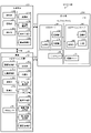
- FIG. 1 is a block diagram showing an example of the configuration of an information processing system according to an embodiment.
- FIG. 2 is a diagram illustrating an example of a display form of guidance information according to the embodiment.
- FIG. 3 is a diagram showing an example of a display form of guidance information according to the embodiment.
- FIG. 4 is a diagram illustrating an example of a display form of guidance information according to the embodiment.
- FIG. 5 is a diagram showing an example of a display form of parking position information according to the embodiment.
- FIG. 6 is a diagram showing an example of a display form of parking position information according to the embodiment.
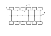
- FIG. 7 is a diagram showing an example of parking lot network data according to the embodiment.
- FIG. 8 is a diagram showing an example of a display form of fullness information according to the embodiment.
- FIG. 9 is a sequence diagram illustrating an example of an information processing procedure performed in the information presentation system according to the embodiment.
- FIG. 10 is a sequence diagram showing an example of an information processing procedure executed in the parking position notification system according to the embodiment.
- FIG. 11 is a diagram showing a hardware configuration example of the navigation device according to the embodiment.
- the information presentation method is capable of communicating with an information processing device having fullness information indicating vacant parking spaces in the parking lot 200 via a network, and displays guidance information for guiding the vehicle 100. It is used in an information presentation system 10A using a navigation device 30 that guides users to a destination by doing so. Specifically, the information presentation method is to specify the position of the vehicle based on the parking lot network data, select a parking space suitable for parking from among the available parking spaces in the parking lot 200, and select from the current location. Guidance information for guiding the vehicle 100 to the designated parking space is output.
- a parking space is, for example, a space in which one vehicle can be parked.
- the parking position notification method is used in the parking position notification system 10B that notifies the user of information regarding the position where the vehicle 100 is parked.
- the parking position reporting method acquires information about the parking lot 200 in which the vehicle 100 is parked, and reports the position information of the vehicle 100 at the time the parking is detected.
- FIG. 1 is a block diagram showing an example of the configuration of an information processing system 10 according to an embodiment.
- this embodiment exemplifies an information processing system 10 configured to function as an information presentation system 10A and a parking position notification system 10B.
- the information presentation system 10 ⁇ /b>A is a system for presenting guidance information that guides the vehicle 100 to a parking space in the parking lot 200 .
- the parking position notification system 10B is a system for notifying the user of information regarding the position where the vehicle 100 is parked.
- the information processing system 10 includes an operation terminal 20, a navigation device 30, and an infrastructure system 40, as shown in FIG.
- the operation terminal 20, the navigation device 30, and the infrastructure system 40 communicate with each other through the communication network NW.
- the communication network NW is, for example, a mobile phone network with many base stations as terminals, a satellite communication network using communication satellites, or the like.
- the information presentation system 10A and the parking position notification system 10B may have a common system configuration or may have independent system configurations.
- the information presentation system 10A and the parking position notification system 10B have mutually independent system configurations, the information presentation system 10A only needs to have a function of realizing the information presentation method among the functions of the information processing system 10. .
- the parking position notification system 10B only needs to have a function of implementing the parking position notification method among the functions of the information processing system 10 .
- the navigation device 30 is capable of communicating via a network with an infrastructure system 40 having fullness information indicating vacant parking spaces in the parking lot 200, and is a device for guiding the vehicle 100 to its destination. is.
- Navigation device 30 is mounted on vehicle 100 .
- the navigation device 30 includes a request unit 30A, an acquisition unit 30B, a self-position estimation unit 30C, a map matching unit 30D, a route generation unit 30E, a parking section selection unit 30F, a guidance information generation unit 30G, a screen generation unit 30H, and a screen control unit 30I. , a parking detection unit 30J, a storage unit 30K, and a control unit 30L.
- the request unit 30A transmits the parking lot network data, full-occupancy information, and floor map data regarding the parking lot 200 installed in the facility set as the destination by the user via the reception unit 20G of the operation terminal 20 to the infrastructure system 40. make a request to
- the acquisition unit 30B acquires the parking lot network data, full/empty information, and floor map data requested by the request unit 30A.
- the self-position estimation unit 30C is a process of estimating where the vehicle 100 is located in the road network data or the parking lot network data based on the information acquired from the internal sensor 90 mounted on the vehicle 100. Perform position estimation.
- a known method may be used for the self-position estimation method, and the self-position estimation method is not limited.
- the map matching unit 30D identifies the self-position estimated by the self-position estimation unit 30C by map matching. For example, the map matching unit 30D compares the travel locus of the vehicle 100 specified based on the information acquired from the internal sensor 90 and the vector data around the vehicle 100 in road network data or parking lot network data. Next, the map matching unit 30D identifies vector data similar to the shape of the travel locus of the vehicle 100 as the actual travel route. Further, the map matching unit 30D identifies the vehicle position in road network data or parking lot network data based on the identified travel route.
- the route generation unit 30E generates a route from the current location of the vehicle 100 to the destination. For example, the route generator 30E generates a route from the current location of the vehicle 100 to the facility based on the road network data and the vehicle position. Alternatively, the route generation unit 30E creates a route from the entrance of the parking lot 200 installed in the facility to the parking space selected by the parking space selection unit 30F based on the parking lot network data and the vehicle position. Generate.
- the parking section selection unit 30F selects the destination parking section based on the parking lot network data and the fullness information. For example, when the navigation device 30 further has floor map data indicating the layout of shops included in the destination facility, the parking section selection unit 30F selects the floor map data in addition to the parking lot network data and fullness information. Based on the map data, select a parking space close to the store you plan to visit. By selecting a parking space in this way, even in a large parking lot, it is possible to move smoothly between the parking space and the store to be visited.
- the store included in the facility is an example of a section that the user plans to visit. Note that the section that the user plans to visit is not limited to the store, and may be an event space in the facility, an area including a plurality of stores, or the like.
- the guidance information generation unit 30G generates guidance information that guides the vehicle 100 to the destination. Specifically, when the facility selected by the user is set as the destination, the guidance information generation unit 30G generates a parking lot based on the road network data and the vehicle position on the route to the parking lot 200. Guidance information indicating the route to the entrance of 200 is generated. Between the route from the entrance of the parking lot 200 to the selected parking space, the guide information generator 30G indicates the route to the selected parking space based on the parking lot network data and the vehicle position. Generate guidance information.
- the screen generation unit 30H generates an image to be displayed on the display device of the navigation device 30.
- the screen control unit 30I outputs the image generated by the screen generation unit 30H to the display device of the navigation device 30.
- the screen controller 30I displays the image to the user on the display device of the navigation device 30.
- the screen control unit 30I displays as an image guide information that guides the vehicle 100 from the current location of the vehicle 100 to the parking section in the parking lot 200 .
- the guidance information may be output to the display device of the operation terminal 20 .
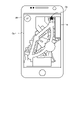
- the image showing the guide information is, for example, like the display image 2 shown in FIG. It includes a display 2c of the parking section selected as the destination from among the parking sections in the parking lot 200, and a display 2d of the route from the current location to the facility.
- the image indicating the guidance information may be, like the display image 3 shown in FIG. It includes a display 3b and a display 3c of the route from the current location to the selected parking space.
- the image showing the guidance information may be, for example, display image 4 shown in FIG. and a display 4c showing a steering operation on the route of .
- the display image 4 exemplifies a parking space dedicated to light vehicles as a mark display 4b.
- the display image 4 also exemplifies an arrow indicating a right turn 10 meters ahead from the current position as a display 4c indicating a steering operation.
- the display image 4 may be superimposed and displayed on the display image 3, for example.
- the parking detection unit 30J detects that the vehicle 100 is parked.
- the parking detection unit 30J detects parking when, for example, the vehicle 100 is put into a reverse range.
- the parking detection unit 30J detects parking when the vehicle position specified by the map matching unit 30D exists in the parking space selected as the destination in the parking lot network data.
- the accumulation unit 30K accumulates the information acquired by the navigation device 30.
- the accumulation unit 30K accumulates, for example, parking lot network data, full-vacancy information, parking lot congestion information, floor map data, store entrance position data, and walking network data acquired from the infrastructure system 40. do.
- the accumulation unit 30K accumulates road network data and traffic congestion information.
- the control unit 30L controls the request unit 30A, the acquisition unit 30B, the self-position estimation unit 30C, the map matching unit 30D, the route generation unit 30E, the parking section selection unit 30F, the parking detection unit 30J, the accumulation unit 30K, and the like.
- the control unit 30L outputs, for example, the position information of the vehicle 100 at the time when parking is detected to the operation terminal 20 as parking position information.
- the operation terminal 20 is a terminal that receives instructions from a user.
- the operation terminal 20 is an example of an information display device.
- a smartphone will be described as an example of the operation terminal 20 .
- the operation terminal 20 has functions as a communication section 20A, a destination setting section 20B, a screen generation section 20C, a screen control section 20D, a control section 20E, a storage section 20F, and a reception section 20G.
- the communication unit 20A transmits and receives information to and from the navigation device 30 and the infrastructure system 40.
- the communication unit 20A receives parking position information, which is information indicating the position where the vehicle 100 is parked, from the navigation device 30 via a known communication line such as Bluetooth (registered trademark).
- the destination setting unit 20B transmits to the navigation device 30 an instruction to set the facility selected by the user via the reception unit 20G and the store included in the facility as the destination.
- the screen generation unit 20C generates an image to be displayed on the display device of the operation terminal 20.
- the screen control unit 20D outputs the image generated by the screen generation unit 20C to the display device of the operation terminal 20.
- the screen control unit 20D displays the image to the user on the display device of the operation terminal 20.
- FIG. For example, the screen control unit 20D displays parking position information, which is information indicating the position where the vehicle 100 is parked, as an image.
- FIGS. 5 and 6 are diagrams each showing an example of a display form of the parking position information according to the embodiment.
- the image indicating the parking position information includes, for example, a display 5a of the layout of the parking space and a display 5b of the position of the parking space where the vehicle is parked, like the display image 5 shown in FIG.
- the indication 5b of the position of the parked parking space is displayed using a predetermined symbol, for example an asterisk.
- the position of the parking space where the vehicle is parked may be displayed using character information, for example, in the same manner as display 2c in FIG.
- the image indicating the parking position information is an image indicating the access opening to the parking lot 200 that is closer to the parking space where the vehicle is parked, such as the display image 6 shown in FIG.
- the image indicating the parking position information includes a display 6a of the layout of the store and the entrance in the facility, and a display 6b of the position of the entrance near the parking space where the car was parked. including.
- the control unit 20E controls the communication unit 20A, the destination setting unit 20B, the screen generation unit 20C, the screen control unit 20D, the accumulation unit 20F, and the reception unit 20G based on the information acquired by the operation terminal 20.
- the accumulation unit 20F accumulates the information acquired by the operation terminal 20.
- the accumulation unit 20F accumulates, for example, parking position information.
- the reception unit 20G receives instructions or information input from the user.
- the operation terminal 20 has been described using a smartphone as an example, but the operation terminal 20 may be directly connected to the navigation device 30 or may be connected via a network.
- the operation terminal 20 directly connected to the navigation device 30 for example, an in-vehicle display device functioning as a car navigation system can be cited.
- Examples of the operation terminal 20 connected to the navigation device 30 via a network include portable information terminals such as smart phones and tablets.
- the operation terminal 20 and the navigation device 30 may be integrated.
- the navigation device 30, for example, similarly to the operation terminal 20, further has functions as a reception unit that receives user operations and a destination setting unit that sets a destination according to the received user operations. good too.
- the user can select the facility display 2a or the store display 2b in the display image 2 in FIG. 2, and input or select the destination.
- the reception unit receives input or selection of the destination by the user.
- the destination setting unit sets or changes the destination according to the user's input or selection received by the receiving unit.
- the infrastructure system 40 is a server system for managing the parking lot 200 installed at the facility set as the destination by the user.
- the infrastructure system 40 is an example of an information processing device having fullness information indicating vacant parking spaces in the parking lot 200 .
- the infrastructure system 40 includes a WEB server 50 , a navigation server 60 , a recognition server 70 and an infrastructure camera 80 .
- the WEB server 50 provides information acquired from the navigation server 60 to the operation terminal 20 and the navigation device 30 via the network. Alternatively, the WEB server 50 acquires information from the operation terminal 20 and the navigation device 30 .
- the WEB server 50 has functions as a communication section 50A, a processing section 50B, and a storage section 50C.
- the communication unit 50A transmits and receives information to and from the navigation device 30 and the navigation server 60.
- the communication unit 50A through a known communication line such as Bluetooth (registered trademark), acquires the full-occupancy information, parking lot network data, floor map data, store entrance position data, and parking lot congestion information acquired from the navigation server 60. information and network data for walking to the navigation device 30;
- the processing unit 50B processes information transmitted and received by the communication unit 50A.
- the accumulation unit 50C accumulates the information acquired by the WEB server 50.
- the accumulation unit 50C accumulates, for example, full-occupancy information, parking lot network data, floor map data, store entrance position data, parking lot congestion information, and walking network data.
- the navigation server 60 acquires from the recognition server 70 real-time updated full-occupancy information, parking lot network data, floor map data, parking lot congestion information, and network data for walking, and provides them to the WEB server 50 .
- the navigation server 60 as shown in FIG. 1, has functions as a communication section 60A, a DB (database) section 60B, and a storage section 60C.
- the communication unit 60A transmits and receives information to and from the WEB server 50 and the recognition server 70.
- the communication unit 60A provides real-time updated full-occupancy information, parking lot network data, floor map data, store entrance position data, and parking lot congestion information via a known communication line such as Bluetooth (registered trademark). , and walking network data to the WEB server 50 .
- the DB section 60B manages information acquired by the navigation server 60.
- the accumulation unit 60C accumulates the fullness information, parking lot network data, floor map data, store entrance position data, parking lot congestion information, and walking network data acquired by the navigation server 60.
- the recognition server 70 updates the full-occupancy information and parking lot congestion information in real time, and stores the updated parking lot information in the navigation server 60 . Specifically, the recognition server 70 detects whether or not the parking space is vacant by analyzing the image taken by the infrastructure camera 80 provided in the parking lot 200, and updates the fullness information in real time. do. Alternatively, the recognition server 70 detects the position of the vehicle 100 traveling on the roadway in the parking lot 200 by analyzing the image captured by the infrastructure camera 80 provided in the parking lot 200, and detects the parking lot congestion information. are updated in real time.
- Infrastructure camera 80 is a sensor that observes the inside of parking lot 200 .
- the infrastructure camera 80 captures, for example, a parking space and a roadway in the parking lot 200 to obtain image data of the parking lot.
- the infrastructure camera 80 is a digital camera, a stereo camera, or the like.
- the parking lot image data is digital image data in which a pixel value is defined for each pixel.
- the installation position and angle of view of the infrastructure camera 80 are adjusted in advance so that the inside of the parking lot 200 can be photographed.
- a plurality of infrastructure cameras 80 with different photographing directions are provided in parking lot 200 .
- the internal sensor 90 is mounted on the vehicle 100 and is a sensor that observes information of the vehicle itself. Internal sensor 90 detects the position of vehicle 100, the speed of vehicle 100, the acceleration of vehicle 100, or the like.
- the internal sensor 90 is, for example, an inertial measurement unit (IMU), a speed sensor, a vehicle speed pulse, an acceleration sensor, or a GPS (Global Positioning System) receiver.
- IMU inertial measurement unit
- a GPS receiver receives radio waves carrying downlink data including positioning data from a plurality of GPS satellites. The positioning data is used to detect the absolute position of the vehicle 100 from latitude and longitude information.
- FIG. 7 Information Acquired by Information Presentation System 10A and Parking Position Notification System 10B
- Information used in the information presentation system 10A and the parking position notification system 10B will be described with reference to FIGS. 7 and 8.
- FIG. 7 Information Acquired by Information Presentation System 10A and Parking Position Notification System 10B
- the parking lot network data is information used to set a route to a parking space as a destination in the parking lot 200 installed in the facility set as the destination by the user.
- the parking lot network data holds various information about parking spaces and lanes in the parking lot 200 as attributes.
- FIG. 7 is a diagram showing an example of parking lot network data according to the embodiment.
- the parking lot network data is, for example, as shown in FIG. 7, parking links 7b, which are vector data connecting parking points 7a indicating respective parking spaces in the parking lot 200, and vectors indicating roads in the parking lot 200. It is composed of lane links 7c, which are data.
- the parking lot network data may be stored in the storage unit 30K of the navigation device 30 or may be stored in the storage unit 60C of the navigation server 60.
- the acquisition unit 30B retrieves the parking lot network data from the storage unit 30K in response to the parking lot network data being requested by the request unit 30A. get. In other words, parking lot network data is read out in the navigation device 30 .
- the fullness information is information indicating vacant parking spaces in the parking lot 200 .
- the recognition server 70 analyzes the image captured by the infrastructure camera 80 provided in the parking lot 200 and detects whether the parking space is vacant or not, thereby updating the fullness information in real time. be done.
- the means for acquiring the fullness information is not limited to the infrastructure camera 80, and the fullness information may be acquired using a sensor capable of detecting vehicles.
- area-by-area fullness information may be calculated that indicates the occupancy rate, which is the percentage of parking lots that are not vacant, for each area.
- An area is a certain range of places separated by a predetermined rule in the parking lot 200, and is, for example, a layer for each parking building.
- FIG. 8 is a diagram showing an example of a display form of fullness information according to the embodiment.
- the image showing area-by-area vacancy information includes a display 8a of the occupancy rate of each floor for each parking building, like the display image 8 shown in FIG.
- the display image 8 exemplifies the building A parking lot and the building B parking lot as the parking buildings.
- the building A parking lot and the building B parking lot are multilevel parking lots.
- the same display is possible even if one of the parking lots is a flat parking lot.
- the parking lot congestion information is information indicating the state of mixture of roads in the parking lot 200 .
- the recognition server 70 analyzes an image captured by the infrastructure camera 80 provided in the parking lot 200, and detects the position of the vehicle 100 traveling on the roadway in the parking lot 200. Traffic congestion information is updated in real time.
- the means for acquiring the parking lot congestion information is not limited to the infrastructure camera 80, and the fullness information may be acquired using a sensor capable of detecting vehicles.
- the floor map data is information indicating the layout of shops included in the facility set as the destination by the user.
- the floor map data may be stored in the storage section 30K of the navigation device 30 or stored in the storage section 60C of the navigation server 60. FIG.
- the store connection position data is information indicating the position of the connection between the facility set as the destination by the user and the parking lot 200 installed at the facility.
- the store contact point position data may be stored in the storage unit 30K of the navigation device 30 or may be stored in the storage unit 60C of the navigation server 60.
- Road network data is information used to set a route to a facility set as a destination by the user.
- Road network data is data that holds various information about roads as attributes, and is composed of vector data that connects straight lines that include latitude and longitude information.
- Vector data may be assigned to each road, or vector data may be assigned to each lane of the road.
- the traffic congestion information is information indicating traffic congestion conditions on roads from the departure point to the destination. Traffic congestion information is obtained from, for example, a VICS (registered trademark) (Vehicle Information Communication System) center or a server device (not shown) that distributes traffic congestion information.
- VICS Registered trademark
- server device not shown
- the walking network data is information used to set and display a route that enables movement from the parking space of the parking lot 200 to the store set as the destination by the user in the shortest distance or in the shortest time.
- the walking network data includes, for example, various information about the parking spaces and roads in the parking lot 200, and various information about the layout of the shops included in the facility set as the destination and the positions of the shop entrances as attributes. Hold.
- the walking network data may be stored in the storage unit 30K of the navigation device 30 or may be stored in the storage unit 60C of the navigation server 60.
- FIG. 9 is a sequence diagram showing an example of the procedure of information processing executed in the information presentation system 10A according to the embodiment.
- the infrastructure camera 80 provided in the parking lot 200 acquires parking lot image data of the parking lot and the roadway in the parking lot 200 (step S101).
- the infrastructure camera 80 outputs the parking lot image data acquired in step S101 to the recognition server 70 of the infrastructure system 40 (step S102).
- the infrastructure system 40 updates the full-vacancy information and parking lot congestion information in real time, and stores the updated full-vacancy information and parking lot congestion information in the navigation server 60 (step S103).
- the recognition server 70 analyzes the parking lot image data acquired from the infrastructure camera 80 and detects whether or not the parking space is vacant, thereby updating the fullness information in real time and sending it to the navigation server 60.
- the recognition server 70 analyzes the parking lot image data acquired from the infrastructure camera 80 and detects the position of the vehicle 100 traveling on the roadway in the parking lot 200, thereby updating the parking lot congestion information in real time. Stored in the navigation server 60 .
- the user selects a destination commercial complex and a store included in the commercial complex through the reception unit 20G. Note that the user may select only the commercial complex as the destination, or may select a plurality of stores included in the commercial complex as the destination (step S104).
- the destination setting unit 20B transmits to the navigation device 30 an instruction to set the commercial complex and store selected in step S104 as the destination (step S105).
- the navigation device 30 reads the road network data from the current location to the commercial complex, the parking lot network data related to the parking lot 200 installed in the commercial complex, and the floor map data of the commercial complex from the storage unit 30K (step S106).
- the request unit 30A requests the infrastructure system 40 for parking lot network data, full-occupancy information, parking congestion information, and floor map data of the commercial complex regarding the parking lot 200 installed in the commercial complex (step S107).
- the acquisition unit 30B acquires the road network data, full-occupancy information, parking lot congestion information, and floor map data requested in step S107 from the WEB server 50 of the infrastructure system 40 (step S108). Note that the data already stored in the storage unit 30K in step S106 is not acquired from the WEB server 50.
- FIG. 1 is a diagrammatic representation of the acquisition unit 30B.
- the parking section selection unit 30F selects the parking section closest to the store selected by the user from among the vacant parking sections in the parking lot 200 based on the fullness information and the floor map data (step S109).
- the route generation unit 30E generates a route on the public road (step S110). Specifically, the self-position estimation unit 30C executes self-position estimation based on information acquired from an internal sensor 90 such as a GPS receiver. The route generation unit 30E generates a route on a public road from the current location to the entrance of the parking lot 200 of the commercial complex based on the road network data and the estimated self-position.
- the route generation unit 30E generates a route within the parking lot 200 (step S111). Specifically, the route generator 30E generates a route from the entrance of the parking lot 200 to the selected parking space based on the parking lot network data and the self-position estimated by the self-position estimator 30C. .
- the route generation unit 30E generates a route from the entrance of the parking lot 200 to the selected parking space based on the parking lot network data, the self-position estimated by the self-position estimation unit 30C, and the parking lot congestion information. may be generated. By generating a route based on the parking lot congestion information, it is possible to avoid traffic congestion in the parking lot 200 and drive to the parking space.
- the navigation device 30 performs navigation according to the driving situation (step S112). Specifically, the map matching unit 30D identifies the vehicle position by map matching based on the road network data and the parking lot network data. On the public road from the current location to the parking lot 200, the guidance information generator 30G generates guidance information indicating the route to the parking lot 200 based on the road network data and the vehicle position. Between the route from the entrance of the parking lot 200 to the selected parking space, the guide information generator 30G indicates the route to the selected parking space based on the parking lot network data and the vehicle position. Generate guidance information. The control unit 30L displays the generated guide information on the display device of the navigation device 30. FIG.
- the information presentation system 10A even in a multi-storey parking lot or an underground parking lot where GPS radio waves are difficult to reach, guidance is provided to select a parking space in the parking lot and guide the vehicle to the selected parking space. Information can be output.
- the information presentation method executed by the information presentation system 10A it is possible to improve the accuracy of specifying the position of the own vehicle and provide route guidance to the target parking position.
- the navigation device 30 executes an information presentation program.
- the information presentation method is realized by executing an information presentation program in the navigation device 30, for example.
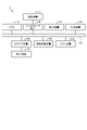
- FIG. 10 is a sequence diagram showing an example of the procedure of information processing executed in the parking position notification system 10B according to the embodiment.
- the navigation device 30 detects arrival at the parking space (step S201). For example, the end of the information presentation system 10A is assumed to be arrival at the parking space.
- the parking detection unit 30J detects parking of the vehicle 100 (step S202).
- the parking detection unit 30J detects parking by, for example, specifying the position of the vehicle by map matching and detecting that the vehicle 100 has approached a parking space.
- the parking detection unit 30J detects parking by, for example, receiving a signal indicating that the vehicle 100 has been put into the reverse range.
- the vehicle 100 notifies the navigation device 30 of the completion of parking (step S203).
- the control unit 30L outputs the position information of the vehicle 100 at the time of detecting parking to the operation terminal 20 as parking position information (step S204).
- the storage unit 20F stores the parking position information output in step S204 (step S205).
- the screen control unit 20D displays the parking position information stored in step S205 as an image on the display device of the operation terminal 20 (step S206). For example, as shown in FIG. 5, the screen control unit 20D displays a display image 5 including a display 5a of the layout of the parking spaces in the parking lot 200 and a display 5b of the position of the parking space where the vehicle is parked on the display device of the operation terminal 20. to display. Alternatively, as shown in FIG. 6, the screen control unit 20D displays a layout 6a of stores and entrances in the commercial complex, and displays the location of the entrance near the parking space in which the vehicle was parked, based on the store entrance position data. The display image 6 including the display 6b of and may be displayed.
- the parking position notification system 10B by notifying the user of the information on the position where the vehicle 100 is parked, the vehicle 100 can be parked even in a large parking lot installed in a large commercial facility. You can smoothly find the position where you made it.
- the parking position notification method executed by the parking position notification system 10B the user is notified of the information regarding the position where the vehicle 100 is parked, even in a place where GPS radio waves do not reach, without introducing equipment to the parking lot 200. can do.
- the operation terminal 20 as an information display device executes an information display program.
- the parking position notification method is realized by executing an information display program on the operation terminal 20 as an information display device, for example.
- the parking section selection unit 30F selects a store in step S109.
- a specific store may be extracted from the stores retrieved, and a parking space close to the extracted store may be selected. For example, if a supermarket, a travel agency, a Chinese restaurant, a movie theater, and a general store are selected as the stores to be visited, the parking section selection unit 30F selects the supermarket, which is expected to have the most luggage, as the specific store. , and from among the vacant parking lots, the parking lot located at the shortest distance from the extracted supermarket is selected.
- the type of store that is expected to increase the number of parcels may be determined in advance and stored in the storage unit 30K. This allows the user to visit the supermarket last, thereby shortening the distance traveled in the commercial complex with luggage. It should be noted that, of the vacant parking lots, the parking lot that can be reached in the shortest time from the extracted supermarket may be selected.
- Modification 2 In the information presentation system 10A, when the parking space information is continuously acquired and the parking space selected in the latest full space information is no longer a vacant parking space, the parking space selection unit 30F obtains the latest full space information. A new destination parking space may be selected based on . As a result, even if the parking space selected in step S109 is occupied by another vehicle, the vehicle can be parked in a parking space other than the occupied parking space.
- the infrastructure system 40 may calculate the travel locus of the vehicle 100 and perform map matching.
- the recognition server 70 detects the position of the vehicle traveling on the road in the parking lot 200 by analyzing the parking lot image data captured by the infrastructure camera 80 installed in the parking lot 200. and the travel locus in the parking lot 200 may be calculated.
- the map matching unit 30D identifies the vehicle position by map matching based on the travel locus calculated by the recognition server 70 in addition to the road network data and parking lot network data.
- the vacancy information may be processed assuming that the selected parking space is an unoccupied parking space.
- the parking section selection unit 30F outputs reservation information indicating the selected parking section to the infrastructure system 40 .
- the infrastructure system 40 updates the full-availability information based on the reservation information, and stores the updated full-availability information in the navigation server 60 .
- the navigation device 30 outputs the reservation information indicating the parking space selected as the destination, thereby causing the infrastructure system 40 to process the fullness information and to identify the parking space as an unoccupied parking space in the fullness information. do.
- step S104 when not only the complex commercial facility but also the store included in the complex commercial facility are selected, the parking position notification system 10B uses the stored parking position as a starting point, and position information indicating the position of the store to be visited.
- the route from the starting point to the ending point may be displayed as an image on the display device of the operation terminal 20 based on the walking network data regarding the commercial complex and the parking lot 200 .
- a route from the starting point to the ending point can be displayed, for example, in the same way as parking position information. This allows the user to efficiently move from the parking space where the user parked to the store.
- FIG. 11 is a diagram showing a hardware configuration example of the navigation device 30 according to the embodiment.
- the navigation device 30 includes, as hardware 11, a CPU (Central Processing Unit) 11A, an interface device 11B, a display device 11C, an input device 11D, a drive device 11E, an auxiliary storage device 11F, a memory device 11G, and a recording medium 11H.
- a CPU Central Processing Unit
- the CPU 11A, interface device 11B, display device 11C, input device 11D, drive device 11E, auxiliary storage device 11F, and memory device 11G are each connected by a bus line 11I.
- a program that implements various functions of the navigation device 30 is provided by, for example, the recording medium 11H.
- the recording medium 11H a computer-readable recording medium such as a CD-ROM, a flexible disk (FD), a CD-R, and a DVD (Digital Versatile Disk) can be used as appropriate.
- the drive device 11E is a device that writes information to the recording medium 11H or a device that reads information from the recording medium 11H.
- the drive device 11E reads the program from the recording medium 11H, the program is installed in the auxiliary storage device 11F.
- the program may be downloaded from another computer via a communication network such as a LAN (Local Area Network) or the Internet and installed in the auxiliary storage device 11F.
- a communication network such as a LAN (Local Area Network) or the Internet and installed in the auxiliary storage device 11F.
- the auxiliary storage device 11F stores various installed programs, as well as necessary files and data.
- Various storage media and storage devices such as ROM (Read Only Memory), HDD (Hard Disk Drive), SSD (Solid State Drive), and Flash memory can be used as the auxiliary storage device 11F.
- the memory device 11G temporarily stores the program read from the auxiliary storage device 11F and the data used by the program when there is an instruction to start the program.
- a RAM Random Access Memory
- a RAM Random Access Memory
- the CPU 11A executes various programs loaded and stored in the memory device 11G, and realizes various functions related to the navigation device 30 according to the programs.
- the interface device 11B is a device that is connected to the communication device 11J and communicates with the communication device 11J.
- the communication device 11J is communication means connected to the communication network NW shown in FIG.
- the display device 11C displays a GUI (Graphical User Interface), for example, according to a program executed by the CPU 11A.
- GUI Graphic User Interface
- a known organic EL (Electro Luminescence) display or a liquid crystal display (Liquid Crystal Display) can be appropriately used.
- the input device 11D receives input of various operating instructions regarding the navigation device 30 from the user of the vehicle 100 or the like.
- the input device 11D is, for example, at least one of an instruction input device that receives input by a user's operation input and a microphone that receives voice input.
- the instruction input device is, for example, a button, a pointing device such as a mouse or a trackball, or a keyboard.
- the instruction input device may be a touch panel provided integrally with the display device 11C.
- the operation terminal 20 is implemented by, for example, the hardware 11 described above.
- the hardware 11 of the operation terminal 20 does not have to include the drive device 11E and the recording medium 11H.
- a program that realizes various functions of the operation terminal 20 is stored in advance in, for example, the auxiliary storage device 11F and provided.
- the CPU 11A executes various programs loaded into the memory device 11G and implements various functions of the operation terminal 20 according to the programs.
- the WEB server 50 and the navigation server 60 are implemented by the hardware 11 described above, for example.
- the hardware 11 of the WEB server 50 and the navigation server 60 need not have the display device 11C and the input device 11D, respectively.
- the CPU 11A executes various programs loaded and stored in the memory device 11G, and realizes various functions related to the WEB server 50 and the navigation server 60 according to the programs.
- the program for executing the information processing has a module configuration including each of the plurality of functional units, and actual hardware includes, for example, a CPU (processor circuit) reads and executes the information processing program from the ROM or HDD, each of the plurality of functional units described above is loaded onto the RAM (main memory), and each of the plurality of functional units described above is loaded onto the RAM (main memory). is generated in .
- a CPU processor circuit
- the CPU 11A of the navigation device 30 loads various programs stored in the auxiliary storage device 11F into the memory device 11G, and executes the loaded programs to obtain the request unit 30A, the acquisition unit 30B, and the self-position estimation unit.
- Functions as 30C, map matching unit 30D, route generation unit 30E, parking section selection unit 30F, guidance information generation unit 30G, screen generation unit 30H, screen control unit 30I, parking detection unit 30J, storage unit 30K, and control unit 30L Realize A program executed in the navigation device 30 is an example of an information presentation program.
- the CPU 11A of the operation terminal 20 loads various programs stored in the auxiliary storage device 11F into the memory device 11G, and executes the loaded programs to generate the communication unit 20A, the destination setting unit 20B, and screen generation. It implements the functions of a unit 20C, a screen control unit 20D, a control unit 20E, a storage unit 20F, and a reception unit 20G.
- a program executed in the operation terminal 20 is an example of an information display program.
- the CPU 11A of the WEB server 50 loads various programs stored in the auxiliary storage device 11F into the memory device 11G, and executes the loaded programs to perform the communication section 50A, the processing section 50B, and the storage section 50C. Realize the function as
- the CPU 11A of the navigation server 60 loads various programs stored in the auxiliary storage device 11F into the memory device 11G, and executes the loaded programs to perform the communication section 60A, the DB section 60B, and the storage section 60C. Realize the function as
- a part or all of each of the plurality of functional units described above can also be realized using dedicated hardware such as ASIC (Application Specific Integrated Circuit) or FPGA (Field-Programmable Gate Array).
- ASIC Application Specific Integrated Circuit
- FPGA Field-Programmable Gate Array
Landscapes
- Engineering & Computer Science (AREA)
- Physics & Mathematics (AREA)
- General Physics & Mathematics (AREA)
- Radar, Positioning & Navigation (AREA)
- Remote Sensing (AREA)
- Business, Economics & Management (AREA)
- Theoretical Computer Science (AREA)
- Automation & Control Theory (AREA)
- Educational Technology (AREA)
- Educational Administration (AREA)
- Economics (AREA)
- General Business, Economics & Management (AREA)
- Computing Systems (AREA)
- Tourism & Hospitality (AREA)
- Mathematical Physics (AREA)
- Operations Research (AREA)
- Human Resources & Organizations (AREA)
- Marketing (AREA)
- Primary Health Care (AREA)
- Strategic Management (AREA)
- General Health & Medical Sciences (AREA)
- Health & Medical Sciences (AREA)
- Development Economics (AREA)
- Accounting & Taxation (AREA)
- Navigation (AREA)
Priority Applications (2)
| Application Number | Priority Date | Filing Date | Title |
|---|---|---|---|
| JP2023508640A JPWO2022201722A1 (https=) | 2021-03-25 | 2021-12-27 | |
| US18/239,462 US20230400322A1 (en) | 2021-03-25 | 2023-08-29 | Computer-readable medium, information display device, and information display method |
Applications Claiming Priority (2)
| Application Number | Priority Date | Filing Date | Title |
|---|---|---|---|
| JP2021-052233 | 2021-03-25 | ||
| JP2021052233 | 2021-03-25 |
Related Child Applications (1)
| Application Number | Title | Priority Date | Filing Date |
|---|---|---|---|
| US18/239,462 Continuation US20230400322A1 (en) | 2021-03-25 | 2023-08-29 | Computer-readable medium, information display device, and information display method |
Publications (1)
| Publication Number | Publication Date |
|---|---|
| WO2022201722A1 true WO2022201722A1 (ja) | 2022-09-29 |
Family
ID=83396728
Family Applications (1)
| Application Number | Title | Priority Date | Filing Date |
|---|---|---|---|
| PCT/JP2021/048695 Ceased WO2022201722A1 (ja) | 2021-03-25 | 2021-12-27 | 情報表示プログラム、情報表示装置および情報表示方法 |
Country Status (3)
| Country | Link |
|---|---|
| US (1) | US20230400322A1 (https=) |
| JP (1) | JPWO2022201722A1 (https=) |
| WO (1) | WO2022201722A1 (https=) |
Families Citing this family (1)
| Publication number | Priority date | Publication date | Assignee | Title |
|---|---|---|---|---|
| JP7323074B2 (ja) * | 2020-07-28 | 2023-08-08 | 株式会社デンソー | 駐車場特定システム、駐車場特定方法、制御装置、センタ装置、および駐車エリア特定方法 |
Citations (2)
| Publication number | Priority date | Publication date | Assignee | Title |
|---|---|---|---|---|
| JP2004020304A (ja) * | 2002-06-14 | 2004-01-22 | Mazda Motor Corp | 情報処理装置、情報処理プログラム、情報処理方法、車載端末及び携帯端末 |
| JP2005084714A (ja) * | 2003-09-04 | 2005-03-31 | Denso Corp | 駐車位置確認システム |
Family Cites Families (13)
| Publication number | Priority date | Publication date | Assignee | Title |
|---|---|---|---|---|
| US5910782A (en) * | 1997-02-25 | 1999-06-08 | Motorola, Inc. | On-board vehicle parking space finder service |
| US7026954B2 (en) * | 2003-06-10 | 2006-04-11 | Bellsouth Intellectual Property Corporation | Automated parking director systems and related methods |
| US7239960B2 (en) * | 2004-02-19 | 2007-07-03 | Alpine Electronics, Inc. | Navigation method and system for visiting multiple destinations by minimum number of stops |
| JP4178154B2 (ja) * | 2005-08-30 | 2008-11-12 | 松下電器産業株式会社 | 駐車位置探索支援装置、方法およびプログラム |
| JP4922875B2 (ja) * | 2007-09-07 | 2012-04-25 | パイオニア株式会社 | 情報案内装置、情報案内システム、情報案内方法、情報案内プログラム、および記録媒体 |
| US20100302068A1 (en) * | 2009-06-01 | 2010-12-02 | Navteq North America, Llc | Street parking community application and method |
| JP2011013085A (ja) * | 2009-07-01 | 2011-01-20 | Aisin Aw Co Ltd | ナビゲーション装置、及びナビゲーションプログラム |
| KR20120086140A (ko) * | 2011-01-25 | 2012-08-02 | 한국전자통신연구원 | 맞춤 자동 주차 서비스를 제공하기 위한 단말과 장치 및 그 방법 |
| US20140350855A1 (en) * | 2012-02-28 | 2014-11-27 | Google Inc. | Systems and Methods for Providing Navigational Assistance to Reserved Parking Locations |
| US8935089B2 (en) * | 2013-05-10 | 2015-01-13 | Blackberry Limited | Mobile mapping in underground or shielded environments |
| US9547988B2 (en) * | 2014-12-22 | 2017-01-17 | Verizon Patent And Licensing Inc. | Personal navigation assistance systems and methods |
| US10445601B2 (en) * | 2016-02-23 | 2019-10-15 | Ford Global Technologies, Llc | Automotive vehicle navigation using low power radios |
| JP2019070966A (ja) * | 2017-10-10 | 2019-05-09 | 株式会社interes | 駐車区画提供方法、駐車区画提供システム、駐車区画提供装置及びコンピュータプログラム |
-
2021
- 2021-12-27 WO PCT/JP2021/048695 patent/WO2022201722A1/ja not_active Ceased
- 2021-12-27 JP JP2023508640A patent/JPWO2022201722A1/ja active Pending
-
2023
- 2023-08-29 US US18/239,462 patent/US20230400322A1/en not_active Abandoned
Patent Citations (2)
| Publication number | Priority date | Publication date | Assignee | Title |
|---|---|---|---|---|
| JP2004020304A (ja) * | 2002-06-14 | 2004-01-22 | Mazda Motor Corp | 情報処理装置、情報処理プログラム、情報処理方法、車載端末及び携帯端末 |
| JP2005084714A (ja) * | 2003-09-04 | 2005-03-31 | Denso Corp | 駐車位置確認システム |
Also Published As
| Publication number | Publication date |
|---|---|
| US20230400322A1 (en) | 2023-12-14 |
| JPWO2022201722A1 (https=) | 2022-09-29 |
Similar Documents
| Publication | Publication Date | Title |
|---|---|---|
| JP6782236B2 (ja) | 注目点情報を提供する方法および装置 | |
| US11087291B2 (en) | Action planning and execution support device | |
| US9761137B2 (en) | Method and apparatus for providing locally relevant rerouting information | |
| JP4736979B2 (ja) | 車載装置、交通情報取得方法、交通情報提供システム及び交通情報提供方法 | |
| JP6068359B2 (ja) | ナビゲーションの方法及びシステム | |
| JP5510007B2 (ja) | 経路探索装置および経路案内システム | |
| US8762051B2 (en) | Method and system for providing navigational guidance using landmarks | |
| US9404763B2 (en) | Departure/destination location extraction apparatus and departure/destination location extraction method | |
| JP2016535277A (ja) | トラフィックフローを最適化する経路の生成 | |
| EP3168572B1 (en) | Navigation system | |
| JP2022538097A (ja) | ナビゲート可能なネットワークに関するユーザ提供データの収集 | |
| JPWO2017110002A1 (ja) | 予測装置、予測システム、予測方法および予測プログラム | |
| US20240257641A1 (en) | Information providing method, information display method, and computer program product | |
| CN113167592A (zh) | 信息处理设备、信息处理方法和信息处理程序 | |
| JP4225194B2 (ja) | ナビゲーションシステム | |
| JP6482198B2 (ja) | ナビゲーションシステム | |
| JP2017096963A (ja) | ナビゲーションの方法及びシステム | |
| JP4906641B2 (ja) | ナビゲーション装置及び情報システム | |
| US20230400322A1 (en) | Computer-readable medium, information display device, and information display method | |
| US20230401959A1 (en) | Information presentation method | |
| JP6198614B2 (ja) | 走行支援装置、サーバ装置および走行支援システム | |
| JP6037817B2 (ja) | 携帯型ナビゲーション装置およびナビゲーション方法 | |
| JP2009002784A (ja) | ナビゲーションシステム、及びその検索方法及び検索プログラム | |
| JP7082588B2 (ja) | プログラム、ナビゲーションシステム、ナビゲーション装置 | |
| US20220018673A1 (en) | Choice modeling for pickup map display content |
Legal Events
| Date | Code | Title | Description |
|---|---|---|---|
| 121 | Ep: the epo has been informed by wipo that ep was designated in this application |
Ref document number: 21933312 Country of ref document: EP Kind code of ref document: A1 |
|
| ENP | Entry into the national phase |
Ref document number: 2023508640 Country of ref document: JP Kind code of ref document: A |
|
| NENP | Non-entry into the national phase |
Ref country code: DE |
|
| 122 | Ep: pct application non-entry in european phase |
Ref document number: 21933312 Country of ref document: EP Kind code of ref document: A1 |