WO2018105179A1 - Dispositif de traitement d'image embarqué - Google Patents
Dispositif de traitement d'image embarqué Download PDFInfo
- Publication number
- WO2018105179A1 WO2018105179A1 PCT/JP2017/031424 JP2017031424W WO2018105179A1 WO 2018105179 A1 WO2018105179 A1 WO 2018105179A1 JP 2017031424 W JP2017031424 W JP 2017031424W WO 2018105179 A1 WO2018105179 A1 WO 2018105179A1
- Authority
- WO
- WIPO (PCT)
- Prior art keywords
- vehicle
- image processing
- feature
- dimensional object
- road surface
- Prior art date
Links
- 238000012545 processing Methods 0.000 title claims abstract description 160
- 239000007787 solid Substances 0.000 claims description 23
- 239000003973 paint Substances 0.000 claims description 20
- 238000000605 extraction Methods 0.000 claims description 13
- 238000003384 imaging method Methods 0.000 claims description 8
- 238000009434 installation Methods 0.000 claims description 8
- 239000000284 extract Substances 0.000 claims description 2
- 238000000034 method Methods 0.000 description 130
- 230000008569 process Effects 0.000 description 123
- 238000001514 detection method Methods 0.000 description 59
- 238000010586 diagram Methods 0.000 description 23
- SEGBBQOGKYETCG-IWSHAHEXSA-N C([C@@H](C(=O)N[C@H](CCCN=C(N)N)C(=O)N[C@@H](CC=1C=CC(O)=CC=1)C(=O)NCCC=1C=CC=CC=1)NC(=O)CC=1C=CC(=CC=1)C=1C=CC=CC=1)SCC1=CC=CC=C1 Chemical compound C([C@@H](C(=O)N[C@H](CCCN=C(N)N)C(=O)N[C@@H](CC=1C=CC(O)=CC=1)C(=O)NCCC=1C=CC=CC=1)NC(=O)CC=1C=CC(=CC=1)C=1C=CC=CC=1)SCC1=CC=CC=C1 SEGBBQOGKYETCG-IWSHAHEXSA-N 0.000 description 19
- 101000804764 Homo sapiens Lymphotactin Proteins 0.000 description 15
- 102100035304 Lymphotactin Human genes 0.000 description 15
- 230000006399 behavior Effects 0.000 description 13
- 230000004048 modification Effects 0.000 description 9
- 238000012986 modification Methods 0.000 description 9
- 230000000630 rising effect Effects 0.000 description 9
- 230000000694 effects Effects 0.000 description 5
- 230000008859 change Effects 0.000 description 4
- 238000004364 calculation method Methods 0.000 description 3
- 240000004050 Pentaglottis sempervirens Species 0.000 description 2
- 235000004522 Pentaglottis sempervirens Nutrition 0.000 description 2
- 230000003287 optical effect Effects 0.000 description 2
- 239000013598 vector Substances 0.000 description 2
- 230000015572 biosynthetic process Effects 0.000 description 1
- 238000006243 chemical reaction Methods 0.000 description 1
- 230000007423 decrease Effects 0.000 description 1
- 238000001914 filtration Methods 0.000 description 1
- 230000010354 integration Effects 0.000 description 1
- 230000007257 malfunction Effects 0.000 description 1
- 238000013507 mapping Methods 0.000 description 1
- 238000005259 measurement Methods 0.000 description 1
- 230000004044 response Effects 0.000 description 1
- 238000003786 synthesis reaction Methods 0.000 description 1
- 230000009466 transformation Effects 0.000 description 1
Images
Classifications
-
- G—PHYSICS
- G06—COMPUTING; CALCULATING OR COUNTING
- G06V—IMAGE OR VIDEO RECOGNITION OR UNDERSTANDING
- G06V20/00—Scenes; Scene-specific elements
- G06V20/60—Type of objects
- G06V20/64—Three-dimensional objects
-
- B—PERFORMING OPERATIONS; TRANSPORTING
- B60—VEHICLES IN GENERAL
- B60R—VEHICLES, VEHICLE FITTINGS, OR VEHICLE PARTS, NOT OTHERWISE PROVIDED FOR
- B60R21/00—Arrangements or fittings on vehicles for protecting or preventing injuries to occupants or pedestrians in case of accidents or other traffic risks
-
- B—PERFORMING OPERATIONS; TRANSPORTING
- B60—VEHICLES IN GENERAL
- B60W—CONJOINT CONTROL OF VEHICLE SUB-UNITS OF DIFFERENT TYPE OR DIFFERENT FUNCTION; CONTROL SYSTEMS SPECIALLY ADAPTED FOR HYBRID VEHICLES; ROAD VEHICLE DRIVE CONTROL SYSTEMS FOR PURPOSES NOT RELATED TO THE CONTROL OF A PARTICULAR SUB-UNIT
- B60W30/00—Purposes of road vehicle drive control systems not related to the control of a particular sub-unit, e.g. of systems using conjoint control of vehicle sub-units
- B60W30/06—Automatic manoeuvring for parking
-
- G—PHYSICS
- G06—COMPUTING; CALCULATING OR COUNTING
- G06T—IMAGE DATA PROCESSING OR GENERATION, IN GENERAL
- G06T7/00—Image analysis
-
- G—PHYSICS
- G06—COMPUTING; CALCULATING OR COUNTING
- G06T—IMAGE DATA PROCESSING OR GENERATION, IN GENERAL
- G06T7/00—Image analysis
- G06T7/60—Analysis of geometric attributes
-
- G—PHYSICS
- G06—COMPUTING; CALCULATING OR COUNTING
- G06V—IMAGE OR VIDEO RECOGNITION OR UNDERSTANDING
- G06V10/00—Arrangements for image or video recognition or understanding
- G06V10/40—Extraction of image or video features
- G06V10/44—Local feature extraction by analysis of parts of the pattern, e.g. by detecting edges, contours, loops, corners, strokes or intersections; Connectivity analysis, e.g. of connected components
-
- G—PHYSICS
- G06—COMPUTING; CALCULATING OR COUNTING
- G06V—IMAGE OR VIDEO RECOGNITION OR UNDERSTANDING
- G06V20/00—Scenes; Scene-specific elements
- G06V20/50—Context or environment of the image
- G06V20/56—Context or environment of the image exterior to a vehicle by using sensors mounted on the vehicle
- G06V20/58—Recognition of moving objects or obstacles, e.g. vehicles or pedestrians; Recognition of traffic objects, e.g. traffic signs, traffic lights or roads
- G06V20/586—Recognition of moving objects or obstacles, e.g. vehicles or pedestrians; Recognition of traffic objects, e.g. traffic signs, traffic lights or roads of parking space
-
- G—PHYSICS
- G06—COMPUTING; CALCULATING OR COUNTING
- G06V—IMAGE OR VIDEO RECOGNITION OR UNDERSTANDING
- G06V20/00—Scenes; Scene-specific elements
- G06V20/50—Context or environment of the image
- G06V20/56—Context or environment of the image exterior to a vehicle by using sensors mounted on the vehicle
- G06V20/588—Recognition of the road, e.g. of lane markings; Recognition of the vehicle driving pattern in relation to the road
-
- G—PHYSICS
- G08—SIGNALLING
- G08G—TRAFFIC CONTROL SYSTEMS
- G08G1/00—Traffic control systems for road vehicles
- G08G1/16—Anti-collision systems
-
- H—ELECTRICITY
- H04—ELECTRIC COMMUNICATION TECHNIQUE
- H04N—PICTORIAL COMMUNICATION, e.g. TELEVISION
- H04N7/00—Television systems
- H04N7/18—Closed-circuit television [CCTV] systems, i.e. systems in which the video signal is not broadcast
Definitions
- the present invention relates to an in-vehicle image processing apparatus that is suitably used when performing vehicle control that assists a driver's driving operation.
- Document 1 discloses an imaging means for imaging the rear of a vehicle, an edge extraction means for extracting an edge from the captured rear image, an image conversion means for converting an image from which an edge has been extracted into an overhead image, and a converted overhead image
- Area dividing means for dividing the left and right areas
- straight line detecting means for detecting straight lines for each area from the divided left and right areas by Hough transform, and whether or not the detected straight line is an end of a line having a width
- a first determining means for determining the width of the straight line and a plurality of straight lines determined to be the ends of the line having a width; Determine if there is Parking space detecting device and a second determination unit is described.
- the bumper, side sill, paint, etc. of the parked vehicle next to the parking frame look the same as the white line of the parking frame on the image, and the edge also forms a rising and falling pair, and the side sill edge And white line may be misidentified as a parking frame. That is, there is a problem that a part of the three-dimensional object is erroneously recognized as a parking frame.
- the present invention has been made in view of the above points, and an object of the present invention is to detect a part of a three-dimensional object when detecting an object existing on a road surface such as a parking frame using a camera image. It is providing the vehicle-mounted image processing apparatus which can avoid misrecognizing as a target object.
- the present invention includes a plurality of means for solving the above problems.
- the present invention is an in-vehicle image processing apparatus that recognizes an object around the own vehicle, the self-image captured by the imaging unit.
- An image acquisition unit that acquires an image around the vehicle, and the feature amount of the target object when the feature amount of the object is assumed to be on the road surface from the image around the vehicle acquired by the image acquisition unit.
- a feature amount extraction unit that extracts coordinate information for a vehicle, a solid object information storage unit that acquires and stores coordinate information of the three-dimensional object around the vehicle, and the feature detected by the feature amount extraction unit Whether the feature value is on the road surface or on a three-dimensional object using the positional relationship between the coordinate information of the amount of the vehicle and the coordinate information of the three-dimensional object stored in the three-dimensional object information storage unit
- a feature amount selecting unit for selecting Using as the selected feature quantity on a road surface in an amount sorting unit, characterized in that it comprises a and the object recognition unit recognizes the object.
- an object having no height such as a parking frame, road surface paint or curb
- vehicle control is performed to assist the driver's parking operation according to the detection result.
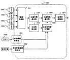
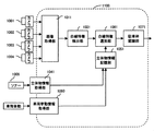
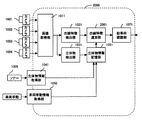
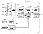
- FIG. 1 is a block diagram of an in-vehicle image processing apparatus 1000 according to the first embodiment.
- the in-vehicle image processing apparatus 1000 is incorporated in a camera apparatus mounted on an automobile, an integrated controller, or the like, and is an apparatus for detecting an object from images captured by the cameras 1001 to 1004 of the camera apparatus. .
- the in-vehicle image processing apparatus 1000 according to the present embodiment is configured to detect a parking frame around the host vehicle 10 as an object.
- the in-vehicle image processing apparatus 1000 is configured by a computer having a CPU, a memory, an I / O, and the like. A predetermined process is programmed, and the process is repeatedly executed at a predetermined cycle T.
- the in-vehicle image processing apparatus 1000 includes an image acquisition unit 1011, a white line feature detection unit (feature amount extraction unit) 1021, a three-dimensional object detection unit 1031, a three-dimensional object information acquisition unit 1041, and a vehicle A behavior information acquisition unit 1050, a three-dimensional object information storage unit 1051, a white line feature selection unit (feature amount selection unit) 1061, and a parking frame recognition unit (object recognition unit) 1071 are provided.
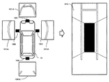
- the image acquisition unit 1011 captures the surroundings of the host vehicle 10 from cameras (imaging units) 1001, 1002, 1003, and 1004 attached at positions where the periphery of the host vehicle 10 can be captured. Obtained images 1011A, 1012A, 1013A, and 1014A are acquired. Thereafter, the obtained images 1011A, 1012A, 1013A, and 1014A are geometrically transformed and combined to generate an overhead image 1015 looking down from the virtual viewpoint in the sky, and stored on the RAM. It is assumed that geometric transformation / synthesis parameters are set in advance by calibration performed at the time of vehicle shipment. Note that the bird's-eye view image 1015 is a two-dimensional array and is represented by IMGSRC [x] [y]. x and y indicate the coordinates of the image, respectively.
- the white line feature detection unit 1021 detects the white line feature LC [n] from the overhead image 1015 acquired by the image acquisition unit 1011.
- the white line feature LC [n] has information on the coordinates of the relative position of the white line feature with respect to the own vehicle 10 in the coordinate (world coordinate) system with the center of the axle of the rear wheel of the own vehicle 10 as the origin. Is a one-dimensional array. n represents an ID when a plurality is detected. Details of the processing will be described later.
- the three-dimensional object detection unit 1031 uses the images 1011A, 1012A, 1013A, and 1014A acquired by the cameras 1001, 1002, 1003, and 1004, respectively, to calculate the distance point group IPT [b] to the three-dimensional object around the host vehicle 10.
- the distance point group IPT [b] is a one-dimensional array having as an element a table having information such as distance coordinates to a three-dimensional object, and b represents an ID when a plurality is detected. Details of the processing will be described later.
- the three-dimensional object information acquisition unit 1041 acquires three-dimensional object information existing around the own vehicle 10 detected by the sonar 1005 provided on the front, rear, and side surfaces of the own vehicle 10 as a distance point group SPT [c].
- the distance point group SPT [c] is a one-dimensional array having as an element a table having information such as the coordinates of the distance coordinates to the three-dimensional object, and c represents an ID when a plurality is detected.
- the vehicle behavior information acquisition unit 1050 uses a vehicle behavior DRC calculated by using an EC mounted on the host vehicle 10 or a pulse of the tire of the host vehicle 10 in the in-vehicle image processing apparatus 1000, and the like as an in-vehicle network CAN. To get via.
- the vehicle behavior DRC includes speed (VX, VY) and yaw rate (YR) information with respect to the world coordinate system.
- the three-dimensional object information storage unit 1051 includes a distance point group IPT [b] detected by the three-dimensional object detection unit 1031, a distance point group SPT [c] acquired by the three-dimensional object information acquisition unit 1041, and a vehicle behavior information acquisition unit 1050. Using the vehicle behavior DRC acquired in step 1, the three-dimensional object point group OPT [d] including the past detection results is integrated and stored. Details of the processing will be described later.
- the white line feature selection unit 1061 includes the white line feature LC [n] obtained from the white line feature detection unit 1021, the solid object point group OPT [d] integrated and stored in the solid object information storage unit 1051, and the camera in the world coordinate system.
- the white line LN [m] on the road surface is selected from the white line feature LC [n] using the camera geometric information CLB which is the coordinate position information. Details of the processing will be described later.
- the parking frame recognition unit 1071 recognizes the parking frame using the white line LN [m] selected as the one on the road surface by the white line feature selection unit 1061. Details of the processing will be described later.
- Information on the parking frame recognized by the parking frame recognition unit 1071 is output to other control units in the host vehicle 10 outside the in-vehicle image processing apparatus 1000, and automatic driving control and automatic parking control in the other control units. It is used when executing each control such as parking support control.
- FIG. 3 is a flowchart showing the processing flow of the white line feature detection unit 1021.
- the white line feature detection unit 1021 may be performed on the entire overhead image 1015 or may limit the processing region.
- the upper half of the bird's-eye view image 1015 is set as a processing area when the host vehicle is stopped or moving forward, and the lower half is set when the host vehicle is moving backward.
- step S301 the overhead image 1015 is rotated by 90 degrees.
- step S302 an edge filter in the horizontal direction (vertical direction in the original image) is applied to each line in the processing region while scanning from the left to the right of the image.
- step S303 and step S304 are performed for each line.
- step S303 an edge point at which the output value of the edge filter reaches a peak is detected.
- a rising edge (a change point from luminance dark to light) Eu [nu]
- a falling edge (a change point from luminance light to dark) Ed [nd] are extracted.
- step S304 among the rising edge point Eu [nu] and the falling edge point Ed [nd] detected in step S303, a predetermined range on the right side of the image from the rising edge (predefined detection Only the edge pair Ep [np] in which a falling edge exists within the maximum thickness of the white line) is left, and the other single edges are deleted as singular points.
- steps S302 to S304 are executed for each line in the processing area.
- a straight line candidate group Lg [ng] is generated by grouping the edge pairs Ep [np] extracted in step S304 that are arranged in a straight line.
- edge pairs that are not linear are removed.
- the grouping of white lines arranged on a straight line is possible by using a known Hough transform.
- step S306 filtering processing is performed to remove lines having a predetermined length or less from the lines of the straight line candidate group Lg [ng].
- step S307 the image coordinates of the upper and lower ends (respectively, the start point and the end point) of the rising and falling edges of the remaining group and the relative position with respect to the vehicle in the world coordinate system calculated from the overhead image 1015 are displayed.
- the coordinate information is stored as an element of the white line candidate LC [n].
- the case where the image is rotated in step S301 and the processing in steps S302 to S307 is performed on the rotated image has been described.
- the overhead image 1015 is scanned in the vertical direction without being rotated, and the horizontal direction. It is also possible to carry out a process using a filter for detecting the edge of the.
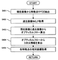
- FIG. 4 is a flowchart showing a process flow of the three-dimensional object detection unit 1031.
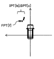
- 5A and 5B are explanatory diagrams of the processing of the three-dimensional object detection unit 1031.
- the three-dimensional object detection unit 1031 is performed on any one or more of the images 1011A, 1012A, 1013A, and 1014A. That is, only one image or all images may be implemented. In this embodiment, it shall carry out with respect to the image of the advancing direction according to the shift position of the own vehicle.
- a feature point FPT [f] is extracted from the current image IMG_C to be processed.
- the feature point FPT [f] is extracted using a known method such as a Harris corner.
- step S402 a past image IMG_P before a predetermined time, acquired from the camera that captured the image from which the feature point FPT [f] is extracted, is acquired.
- step S403 the corresponding position on the past image IMG_P of each feature point FPT [f] on the current image IMG_C is calculated by the optical flow method, and the movement vectors FPT_VX [f], FPT_VY [ f].
- the optical flow a known method such as the Lucas-Kanade method is used.
- step S404 the feature point FPT [f] and the movement vectors FPT_VX [f], FPT_VY [f] are used to calculate the three-dimensional position of each feature point FPT [f] around the host vehicle 10.
- a calculation method a known means is used.
- step S405 the three-dimensional position of each feature point is converted into a coordinate system (world coordinate system) with the rear wheel axle center of the vehicle as the origin, and stored as a distance point group IPT [b].
- the calculation principle is performed by measuring the distance using the fact that parallax is generated by the change in the past vehicle position and the current vehicle position.
- the measurement result for the parked vehicle is obtained as a plurality of point groups having world coordinates as shown in FIG. 5B.
- FIG. 6 is a flowchart showing a process flow of the three-dimensional object information storage unit 1051.
- 7A to 7D are explanatory diagrams of processing of the three-dimensional object information storage unit 1051.
- the three-dimensional object information storage unit 1051 sets the distance point group IPT [b] calculated by the three-dimensional object detection unit 1031 and the sonar distance point group SPT [c] acquired from the three-dimensional object information acquisition unit 1041 as past values. Including and remembering.
- the three-dimensional object information storage unit 1051 manages all obstacle information using a two-dimensional map EMP having a certain position as the origin and no height information.
- the three-dimensional object information storage unit 1051 uses the vehicle behavior DRC acquired from the vehicle behavior information acquisition unit 1050 to store the information of the distance point group IPT [b] and the sonar distance point group SPT [c] that are sequentially calculated.
- a two-dimensional map EMP [x] [y] is created by pasting on a two-dimensional map one after another.
- EMP is a two-dimensional array, and x and y are coordinates of the array partitioned by a certain resolution.
- step S601 the previously processed two-dimensional map EMP is acquired.
- step S602 the vehicle behavior DRC is acquired from the vehicle behavior information acquisition unit 1050.
- step S603 the distance point group IPT [b] calculated by the three-dimensional object detection unit 1031 is acquired.
- step S604 the sonar distance point group SPT [c] acquired from the three-dimensional object information acquisition unit 1041 is acquired.
- step S605 Since the acquired distance point group IPT [b] and distance point group SPT [c] have information on relative coordinates with respect to the host vehicle 10, in step S605, the distance point group IPT [b] and sonar by the camera.
- a two-dimensional map EMP is created by mapping the distance point group SPT [c] by the above on a blank map using the vehicle behavior DRC.
- step S606 the point cloud information acquired in the past is removed from all the solid object point cloud OPT [d] mapped on the two-dimensional map EMP, and the point cloud remaining on the map is solidified. Let it be an object point group OPT [d].
- step S 605 when past information or a plurality of sensing results are simultaneously detected in the same grid in step S 605, the certainty is increased.
- step S 606 the total certainty factor is increased.
- a predetermined value can be subtracted.
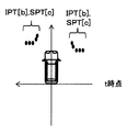
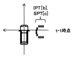
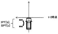
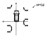
- FIG. 7A to 7D show an example of processing.
- Distance point groups IPT [b] and SPT [c] obtained at time t are obtained in FIG. 7A and distance point groups IPT [b] and SPT [c] obtained at time t-1 are obtained at time t-2 in FIG. 7B.
- FIG. 7C a three-dimensional object that is a result of integration using vehicle behavior DRC at time t, time t-1 and time t-2.
- An example of the point group OPT [d] results as shown in FIG. 7D.
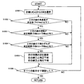
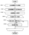
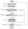
- FIG. 8 is a flowchart showing the processing flow of the white line feature selection unit 1061.
- 9A to 9F are explanatory diagrams of processing of the white line feature selection unit 1061.
- the white line feature selection unit 1061 uses the white line feature LC [n] obtained from the white line feature detection unit 1021, the solid object information OPT [d] obtained from the solid object information storage unit 1051, and the camera installation position information CLB. It is selected whether the feature LC [n] is a white line LN [m] on the road surface, or a bumper, side sill, paint, or the like of an adjacent parked vehicle that is an object on a three-dimensional object.
- step S801 the three-dimensional object information OPT [d] is acquired.
- step S802 camera installation position information CLB is acquired.
- step S803 a white line feature LC [n] is acquired.
- step S805 a triangular area D in two-dimensional coordinates not considering the height is calculated from the three points of the start point coordinates, end point coordinates, and camera installation position coordinates of the white line feature LC [n].
- step S806 it is determined whether or not the three-dimensional object information OPT [d] exists in the triangular area D. If it is determined that it does not exist, the process proceeds to step S807, and the white line feature LC [n] is registered as the white line LN [m]. On the other hand, when it is determined that the white line feature LC [n] is present, it is determined that the white line feature LC [n] is not the white line LN [m], and the process proceeds to a determination process for the next white line feature LC [n].
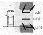
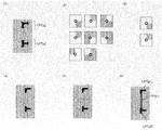
- FIG. 9A shows the result of detecting the white line feature LC [n] from the overhead image 1015.
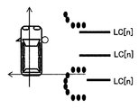
- FIG. 9B shows the solid object information OPT [d]
- FIG. 9C shows the result of superimposing the solid object information OPT [d] and the white line feature LC [n].
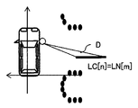
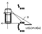
- 9D, FIG. 9E, and FIG. 9F illustrate how the overlap between each triangular region D and the white line feature LC [n] is confirmed.
- FIG. 9A Using the detection position CLB of the camera that detected the white line feature LC [n] and the white line feature LC [n] as shown in FIG. 9A and the detection result of the three-dimensional object information OPT [d] as shown in FIG. 9B, FIG. 3D, the three-dimensional object information OPT [d] and the white line feature LC [n] are overlapped. 9C, three triangular areas D as shown in FIGS. 9D, 9E, and 9F are generated, and it is determined whether or not the three-dimensional object information OPT [d] exists inside each triangular area D.
- the white line feature LC [n] shown in FIG. 9F is removed, and the remaining two white lines shown in FIGS. 9D and 9E.
- the feature LC [n] is registered as a white line LN [m].
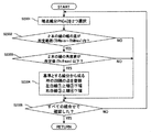
- FIG. 10 is a flowchart showing a processing flow of the parking frame recognition unit 1071.
- the parking frame recognition unit 1071 searches and recognizes a parking frame in which the host vehicle 10 can stop by combining the registered white line LN [m].
- step S1001 two lines LN [mL] and LN [mR] are selected from the white line LN [m].
- step S1002 it is determined whether or not the angular difference ⁇ in the extending direction of the two white lines LN [mL] and LN [mR] selected in step S1001 is equal to or smaller than a predetermined value (Th ⁇ max). That is, in step S1002, it is determined whether or not the two white lines are substantially parallel. If it is determined that the value is less than or equal to the predetermined value, the process proceeds to step S1003. If it is determined that the value is greater than the predetermined value, the selected two white lines LN [mL] and LN [mR] constitute a parking frame. The processing advances to step S1006 assuming that it is not a combination of white lines.
- step S1003 it is determined whether or not the interval W between the two white lines LN [mL] and LN [mR] is within a predetermined range (ThWmin or more and ThWmax or less). That is, in step S1003, it is determined whether or not two white lines are aligned at an interval that can be considered as two white lines constituting the parking frame. If it is determined that the value is within the predetermined range, the process proceeds to step S1004. If it is determined that the value is outside the predetermined range, the process proceeds to step S1006.
- a predetermined range ThWmin or more and ThWmax or less
- step S1003 If the determination in step S1003 is affirmative, the process proceeds to step S1004, and it is determined whether or not the deviation ⁇ B of the lower ends of the two white lines is within a predetermined range (ThBmin or more and ThBmax or less).
- a predetermined range ThBmin or more and ThBmax or less.
- the parking frame 23 is provided so that the own vehicle 10 may be parked in parallel or at a right angle with respect to the moving direction of the own vehicle 10 in the parking lot site (vertical direction and horizontal direction in FIG. 11A).
- the parking frame line 23L is drawn so as to correspond to the parking frame 23, there is no deviation on the lower end side.
- the parking frame may be parked so that the host vehicle 10 is parked diagonally rather than parallel or perpendicular to the moving direction of the host vehicle 10 (vertical direction and horizontal direction in FIG. 11B).
- 23 may be provided, and a parking frame line 23L may be drawn so as to correspond to the parking frame 23.
- the lower end position of the parking frame line 23L constituting the parking frame 23 is shifted. This is because the lower end position of the parking frame line 23L is shifted so that the parking frame line 23L on the right side of FIG. 11B does not protrude from the area where the host vehicle 10 travels.
- a line segment perpendicular to the extending direction of the parking frame line 23L from the lower end of the parking frame line 23L on the left side of FIG. 11B is connected to the lower ends of the parking frame line 23L.
- the intersection angle ⁇ with the line segment is set to 0 degree, 30 degrees, or 45 degrees.
- the range of values that can be taken for the width W of the parking frame 23 is determined. Therefore, in this embodiment, the value of the distance B that can be taken when the intersection angle ⁇ is one of 0 degree, 30 degrees, and 45 degrees is stored in advance in a memory (not shown).
- step S1004 a comparison is performed using the distance B calculated from the selected LN [mL] and LN [mR], and whether or not the difference is within the above-described predetermined range (ThBmin or more and ThBmax or less). By determining, it is determined whether or not the two white lines are white lines (parking frame line 23L) constituting one parking frame 23. If it is determined that the value is within the predetermined range, the process proceeds to step S1005. If it is determined that the value is outside the predetermined range, the process proceeds to step S1006.
- step S1004 If an affirmative determination is made in step S1004, the process proceeds to step S1005, and the coordinates of the four corners of the rectangular parking frame 23 composed of two white lines LN [mL] and LN [mR] are set to the position of one parking frame 23. Register as information PS [k].
- step S1005 the process proceeds to step S1006, where it is confirmed whether or not the above-described processing for any two white lines has been performed for all white lines (parking frame lines) based on the information output from the white line feature selection unit 1061. To do. If an affirmative determination is made in step S1006, the result obtained by the above-described process is output, and the process of the parking frame recognition unit 1071 is terminated. If a negative determination is made in step S1006, the process returns to step S1001, and the above-described process is executed by combining all the white lines LN [m].
- the white line feature of the parking frame is detected, and a triangle composed of the start point / end point obtained from the white line feature and the camera installation position, The process of superimposing the information of the acquired three-dimensional object is performed, it is determined whether the feature quantity of the target object is on the three-dimensional object or the road surface, and the target object is recognized using the feature quantity on the road surface.
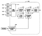
- FIG. 12 is a block diagram of an in-vehicle image processing apparatus 1100 according to a first modification of the present embodiment.
- An in-vehicle image processing apparatus 1100 illustrated in FIG. 12 is an example in which the three-dimensional object detection unit 1031 is not provided with respect to the in-vehicle image processing apparatus 1000 illustrated in FIG.
- the three-dimensional object information storage unit 1051 performs processing only with the result obtained from the three-dimensional object information acquisition unit 1041. That is, step S603 in FIG. 6 is not performed.
- Other configurations and processing are the same as the configurations and processing in the respective units in the first embodiment.
- FIG. 13 is a block diagram of an in-vehicle image processing apparatus 1200 according to a second modification of the present embodiment.
- the in-vehicle image processing apparatus 1200 illustrated in FIG. 13 is an example in which the three-dimensional object information acquisition unit 1041 is not included in the in-vehicle image processing apparatus 1000 illustrated in FIG.
- the three-dimensional object information storage unit 1051 performs processing only with the result obtained from the three-dimensional object detection unit 1031. That is, step S604 of FIG. 6 is not performed.
- Other configurations and processing are the same as the configurations and processing in the respective units in the first embodiment.
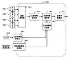
- FIG. 14 is a block diagram of an in-vehicle image processing apparatus 1300 according to a third modification of the present embodiment.
- the in-vehicle image processing apparatus 1300 shown in FIG. 14 is equipped with a LiDAR (Light Detection and Ranging or Laser Imaging Detection and Ranging) 1006 as compared with the in-vehicle image processing apparatus 1000 shown in FIG.
- the acquisition unit 1041 is an example of acquiring information about the LiDAR 1006.
- LiDAR is a device that measures scattered light in response to laser irradiation that emits light in pulses, and analyzes the distance to a target at a long distance and the properties of the target. Since the three-dimensional object can be detected with the LiDAR 1006, the three-dimensional object detection unit 1031 is unnecessary.
- Other configurations and processes are the same as those in the first modification of the first embodiment shown in FIG.
- FIG. 15 is a block diagram illustrating a configuration of the in-vehicle image processing apparatus 2000 according to the second embodiment.
- the in-vehicle image processing apparatus 2000 according to the present embodiment is different from the in-vehicle image processing apparatus 1000 according to the first embodiment in that white line features are used instead of the white line feature selection unit 1061.
- the in-vehicle image processing device 2000 is incorporated in a camera device mounted on an automobile, an integrated controller, or the like, and detects an object from images taken by the cameras 1001 to 1004.
- the in-vehicle image processing apparatus 2000 in the present embodiment is configured to detect a parking frame as an object.
- the in-vehicle image processing apparatus 2000 is configured by a computer having a CPU, a memory, an I / O, and the like. A predetermined process is programmed, and the process is repeatedly executed at a predetermined cycle.
- FIG. 16 is a flowchart showing the processing flow of the white line feature selection unit 2061.
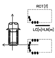
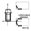
- 17A to 17E are explanatory diagrams of processing of the white line feature selection unit 2061.
- the white line feature selection unit 2061 uses the white line feature LC [n] obtained from the white line feature detection unit 1021 and the solid object information OPT [d] obtained from the solid object information storage unit 1051 without using the camera installation position information CLB. Thus, it is selected whether or not the white line feature LC [n] is the white line LN [m] on the road surface.
- step S1601 the three-dimensional object information OPT [d] is acquired.
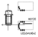
- step S1602 rectangular fitting of a predetermined size is performed on the point group of the three-dimensional object information OPT [d], and a rectangle having a fitting rate equal to or greater than a predetermined value is stored as an approximate rectangle RCT [f].
- a rectangle having a fitting rate equal to or greater than a predetermined value is stored as an approximate rectangle RCT [f].
- the size of the own vehicle is used as the predetermined size.
- step S1603 a white line feature LC [n] is acquired.
- step S1605 it is determined whether a part of the white line feature LC [n] is not included inside any of the rectangles RCT [f]. If it does not exist inside and does not overlap, the process advances to step S1606 to register the white line feature LC [n] as the white line LN [m]. On the other hand, if it is determined that at least part of the rectangle RCT [f] is inside and overlapped, the white line feature LC [n] is not the white line LN [m], and the next white line feature LC [n] Shift to processing for.
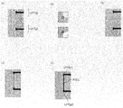
- FIG. 17A shows the result of detecting the white line feature LC [n] from the overhead image.
- FIG. 17B shows the result of the three-dimensional object information OPT [d] and the approximate rectangle RCT [f].
- FIG. 17C, FIG. 17D, and FIG. 17E are diagrams showing how to check the overlap between each approximate rectangle RCT [f] and the white line feature LC [n].
- An approximate rectangle RCT [f] as shown in FIG. 17B is superimposed on the white line feature LC [n] as shown in FIG. 17A, and even part of the white line feature LC [n] is included inside the approximate rectangle RCT [f]. It is determined whether it is not.
- the three-dimensional object information is fitted to a vehicle-equivalent size rectangle, for example, a vehicle-size rectangle.
- a vehicle-equivalent size rectangle for example, a vehicle-size rectangle.
- FIG. 18 is a block diagram illustrating a configuration of an in-vehicle image processing device 3000 according to the third embodiment.
- the in-vehicle image processing device 3000 is an end point feature detection unit (feature amount extraction unit) instead of the white line feature detection configuration of the in-vehicle image processing device 1000 according to the first embodiment. ) 3021, an end point feature selection unit (feature amount selection unit) 3061, and a parking frame recognition unit (object recognition unit) 3071.
- the in-vehicle image processing device 3000 is incorporated in a camera device mounted on an automobile, an integrated controller, or the like, and detects an object from images captured by the cameras 1001 to 1004.
- the in-vehicle image processing device 3000 is configured to detect a parking frame as an object.
- the in-vehicle image processing device 3000 is configured by a computer having a CPU, a memory, an I / O, and the like. A predetermined process is programmed, and the process is repeatedly executed at a predetermined cycle.
- FIG. 19 is a flowchart showing the processing flow of the end point feature detection unit 3021.
- 20A and 20B are explanatory diagrams of processing of the end point feature detection unit 3021.
- the end point feature detection unit 3021 detects end points from the current image IMG_C acquired by the image acquisition unit 1011 and performs a process of detecting end point features PC [n] using the combination.
- step S1901 the overhead image 1015 acquired by the image acquisition unit 1011 is acquired.
- step S1902 the feature point LPT [g] is detected.
- Harris feature points are detected.
- An example in which the feature point LPT [g] is detected is shown in (1) of FIG. 20A and (1) of FIG. 20B.
- a surrounding pattern of the feature point LPT [g] is acquired.
- the end point feature detection unit 3021 acquires a local pattern LPTN [g] from an image having a width and height centered around the feature point and a predetermined pixel.
- the pattern to be acquired may be an image itself, or may be binarized information, or a stored edge rising / falling angle.
- An example of the acquired surrounding pattern is shown in (2) of FIG. 20A.
- step S1906 it is determined whether or not the local patterns LPTN [g1] and LPTN [g2] have a specific pattern shape.
- the specific pattern is a pattern that defines the corner of the parking frame to be detected, and has a pattern shape as shown in (3) of FIG. 20A or (2) of FIG. 20B, for example.
- FIG. 20A (4) and FIG. 20B (3) show the results of leaving LPT [g] of only a specific pattern determined from (1) of FIG. 20A and (1) of FIG. 20B, respectively. If the local patterns LPTN [g1] and LPTN [g2] match the conditions, the process advances to step S1907. If the local patterns LPTN [g1] and LPTN [g2] do not match, the subsequent processing is not performed, and g1 and g2 are incremented to continue the loop processing. .
- step S1907 the local patterns LPTN [g1] and LPTN [g2] are compared in symmetry.
- a pattern LPTN ′ [g2] obtained by inverting the local pattern LPTN [g2] with a perpendicular perpendicular to a line segment connecting two selected points as an axis of symmetry is generated, and LPTN [g1] and LPTN ′ [ g2] is calculated by calculating the degree of coincidence.
- An example of calculation is shown in (5) of FIG. 20A and (4) of FIG. 20B.
- step S1908 it is determined whether or not the degree of coincidence between the local patterns LPTN [g1] and LPTN [g2] is equal to or greater than a predetermined threshold value. If it is equal to or greater than the threshold value, the process proceeds to step S1908. First, g1 and g2 are incremented and loop processing is continued.
- step S1908 a line segment composed of LPT [g1] and LPT [g2] is registered as an end point feature PC [n].
- (6) in FIG. 20A and (5) in FIG. 20B are examples of the line segment PC [n] registered as a result of the above processing.
- FIGS. 21A to 21D are explanatory diagrams of processing of the end point feature selection unit 3061.
- FIG. 21A to 21D are explanatory diagrams of processing of the end point feature selection unit 3061.
- the endpoint feature selection unit 3061 uses the endpoint feature PC [n] obtained from the endpoint feature detection unit 3021, the three-dimensional object information OPT [d] obtained from the three-dimensional object information storage unit 1051, and the camera installation position information CLB. It is selected whether or not the end point feature PC [n] is an end point line segment PN [m] on the road surface.
- the input is changed from the white line feature LC [n] to the end point feature PC [n] in the processing in the white line feature selection unit 1061 described in FIG. Since it is the same except for changing from m] to the end line segment PN [m], the description is omitted.
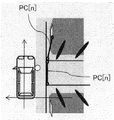
- FIG. 21A is an example in which the end point feature PC [n] is detected, and two end point features PC [n] are detected.
- FIG. 21B is an example in which the end point feature PC [n] and the three-dimensional object information OPT [d] are superimposed.
- FIG. 21C and FIG. 21D illustrate how the end feature PC [n] and the three-dimensional object information OPT [d] are checked for overlap.
- FIG. 22 is a flowchart showing a process flow of the parking frame recognition unit 3071.
- the parking frame recognition unit 3071 searches for and recognizes a parking frame in which the host vehicle 10 can stop by combining the registered end line segment PN [m].
- step S2201 one endpoint line segment PN [m] is selected.
- a reference azimuth angle ⁇ B is acquired.
- various reference orientations ⁇ B can be used.
- the azimuth angle of the host vehicle may be used, or the azimuth of the trajectory traveled by the host vehicle for a predetermined time may be used.
- the average direction of the short side of the detection result of the past parking frame may be used, or the obstacle OPT [d] suitable for the processing inside the white line feature selection unit 2061 of the second embodiment is fitted. The average value of the short sides of the rectangle may be used.
- step S2203 it is determined whether or not the angle difference ⁇ between the angle of the endpoint line segment PN [m] selected in step S2201 and the reference azimuth angle ⁇ B is equal to or smaller than a predetermined value (Th ⁇ max). That is, in step S2203, it is determined whether the endpoint line segment and the reference azimuth are parallel. If it is determined that the value is equal to or smaller than the predetermined value, the process proceeds to step S2204. If it is determined that the value is larger than the predetermined value, the process proceeds to step S2206.
- step S2204 it is determined whether or not the length L of the end line segment PN [m] is within a predetermined range (ThLmin or more and ThLmax or less). That is, in step S2204, it is determined whether or not the interval between the end line segments constituting the short side of the parking frame is a width corresponding to the parking frame. If it is determined that the value is within the predetermined range, the process proceeds to step S2205. If it is determined that the value is outside the predetermined range, the process proceeds to step S2206.
- a predetermined range ThLmin or more and ThLmax or less
- step S2204 If an affirmative determination is made in step S2204, the process proceeds to step S2205, and the coordinates of the four corners of the rectangular parking frame having the short end line segment PN [m] as the short side are registered as position information PS [k].
- the coordinates obtained by the end point line segment are the two points in front of the parking frame, and the end point position in the back of the parking frame is not detected, so that the interpolation is performed based on the length of the own vehicle.
- step S2205 the process proceeds to step S2206, and it is confirmed whether or not the above-described processing has been performed for all end point features (parking frame entrance lines) based on the information output from the end point feature selection unit 3061. If an affirmative determination is made in step S2206, the result obtained by the above-described process is output, and the process of the parking frame recognition unit 3071 is terminated. If a negative determination is made in step S2206, the process returns to step S2201.
- FIG. 23 is a flowchart showing another process flow of the parking frame recognition unit 3071.
- step S2301 two endpoint line segments PN [m] are selected.
- the endpoints are PN [m1] and PN [m2].
- step S2302 whether or not the length difference ⁇ L between the two end line segments PN [m1] and PN [m2] selected in step S2301 is within a predetermined range (Th ⁇ Lmin or more and Th ⁇ Lmax or less). Judging. That is, in step S2302, it is confirmed whether or not there is another line segment similar to the length of the end line segment constituting the short side of the parking frame. If it is determined that the value is within the predetermined range, the process proceeds to step S2303. If it is determined that the value is outside the predetermined range, the process proceeds to step S2305.
- a predetermined range Th ⁇ Lmin or more and Th ⁇ Lmax or less
- step S2303 it is determined whether or not the angle difference ⁇ between the end point line segments PN [m1] and PN [m2] selected in step S2301 is equal to or smaller than a predetermined value (Th ⁇ max). . That is, in step S2303, it is determined whether or not the two end point line segments are parallel. If it is determined that the value is equal to or smaller than the predetermined value, the process proceeds to step S2304. If it is determined that the value is larger than the predetermined value, the process proceeds to step S2305.
- step S2303 If an affirmative determination is made in step S2303, the process proceeds to step S2304, and the coordinates of the four corners of the rectangular parking frame having the short side of the reference end line segment PN [m1] are registered as position information PS [k].
- the coordinates obtained by the end point line segment are the two points in front of the parking frame, and the end point position in the back of the parking frame is not detected, so that the interpolation is performed based on the length of the own vehicle.
- step S2304 the process proceeds to step S2305, where it is confirmed whether or not the above-described processing has been performed on all end point features (parking frame entrance lines) based on the information output from the end point feature selection unit 3061. If affirmative determination is made in step S2305, the result obtained by the above-described process is output, and the process of the parking frame recognition unit 3071 is terminated. If a negative determination is made in step S2305, the process returns to step S2301.
- a pattern such as a license plate of a stationary vehicle may be erroneously recognized as a part of the parking frame.
- these misrecognitions can be removed, and the same effect as the in-vehicle image processing apparatus 1000 of the first embodiment described above can be obtained. can get.
- FIG. 24 is a block diagram illustrating a configuration of an in-vehicle image processing device 4000 according to the fourth embodiment.
- the in-vehicle image processing device 4000 of this embodiment is a road surface paint recognition unit (object recognition unit) instead of the parking frame recognition unit 1071 of the in-vehicle image processing device 1000 of the first embodiment. 4071.
- the in-vehicle image processing device 4000 is incorporated in a camera device mounted on an automobile, an integrated controller, or the like, and detects an object from images captured by the cameras 1001 to 1004.
- the in-vehicle image processing device 4000 is configured to detect road surface paint as an object.
- the in-vehicle image processing device 4000 is configured by a computer having a CPU, memory, I / O, and the like. A predetermined process is programmed, and the process is repeatedly executed at a predetermined cycle.
- FIG. 25 is a flowchart showing the process of the road surface paint recognition unit 4071.
- the road surface paint recognition unit 4071 recognizes the paint pattern on the road surface using LN [m] obtained from the white line feature selection unit 1061. In the present embodiment, processing for recognizing a pedestrian crossing will be described.
- step S2501 one reference white line LN [m1] is selected.
- step S2502 the white line LN [m2] to be referred to is selected, and the processes in steps S2503 to S2505 are performed for all white lines other than m1.
- step S2503 it is determined whether or not the angle difference ⁇ between the reference line segment LN [m1] selected in step S2501 and the reference white line LN [m2] is equal to or smaller than a predetermined value (Th ⁇ max). . That is, in step S2503, it is determined whether the two white lines are parallel. If it is determined that the value is equal to or smaller than the predetermined value, the process proceeds to step S2504. If it is determined that the value is larger than the predetermined value, the loop process is continued.
- step S2503 If an affirmative determination is made in step S2503, the process proceeds to step S2504, and it is determined whether or not the interval W between the two white lines LN [m1] and LN [m2] is within a predetermined range (ThWmin or more and ThWmax or less). That is, in step S2504, it is determined whether or not the two white lines are aligned with an interval equivalent to a pedestrian crossing. If it is determined that the value is within the predetermined range, the process proceeds to step S2505. If it is determined that the value is outside the predetermined range, the loop process is continued.
- a predetermined range ThWmin or more and ThWmax or less
- the determination of the interval W also determines whether W / 2, W / 3, W / 4,... Are within a predetermined range. This means that when an arbitrary white line is selected from a pedestrian crossing, if the white line is adjacent, the interval is within a predetermined range. When the white line is selected, the interval is three times as long, so even if any of the above conditions is met, it is determined that the white line is within the predetermined range.
- step S2504 If a positive determination is made in step S2504, the process proceeds to step S2505, and the pedestrian crossing score PCR [m1] is incremented.
- step S2506 After processing all the white lines LN [m2] to be referred to, the process proceeds to step S2506, and it is determined whether or not the pedestrian crossing score PCR [m1] is equal to or greater than a predetermined threshold. If it is equal to or greater than the threshold value, the process proceeds to step S2507, where a coordinate value, a flag of the detection result, etc. are registered as the detection result. To determine the pedestrian crossing score PCR [m].
- the information on the determined pedestrian crossing is output to other control units in the host vehicle 10 outside the in-vehicle image processing device 4000, and is used when executing various controls of automatic driving control in the other control units.
- the vehicle-mounted image processing device 4000 when detecting road surface paint, can remove features similar to road surface paint existing inside an obstacle, and road surface paint can be removed. Can be recognized correctly.
- the white line feature LC [n] detected by the white line feature detection unit 1021 used in the first embodiment and the white line LN [ m] is used, but as described in the third embodiment, the endpoint feature PC [n] detected by the endpoint feature detector 3021 and the endpoint line segment PN [m] selected by the endpoint feature selector 3061 are It can also be used.
- a pedestrian crossing is taken as an example, but other road surface paints (arrows, speed display, stop, etc.) can be recognized by changing the conditions of the road surface paint recognition unit 4071.
- FIG. 26 is a block diagram illustrating a configuration of an in-vehicle image processing device 5000 according to the fifth embodiment.
- the in-vehicle image processing apparatus 5000 is characterized in comparison with the in-vehicle image processing apparatus 1000 according to the first embodiment. 5021, a curb feature selection unit (feature amount selection unit) 5061, a curb recognition unit (object recognition unit) 5071, and a parking space acquisition unit 5081.
- the in-vehicle image processing device 5000 is incorporated in a camera device mounted on an automobile, an integrated controller, or the like, and detects an object from images captured by the cameras 1001 to 1004.
- the in-vehicle image processing device 5000 is configured to detect a curb as an object.
- the curb as an object in the present embodiment is, for example, present near a region where a plurality of parking frames are arranged and lies in parallel with the frame line, and is a white line for parallel parking provided on a road. Are provided in parallel.
- the in-vehicle image processing device 5000 is configured by a computer having a CPU, memory, I / O, and the like. A predetermined process is programmed, and the process is repeatedly executed at a predetermined cycle.
- the curb feature detection unit 5021 is a process of detecting a line segment that is a curb feature from the image IMG_C acquired by the image acquisition unit 1011.
- the curb feature detection unit 5021 detects an edge from the image using the difference in luminance between the curb and the road surface, and detects a line segment using the rising and falling intervals. Since this process may be the same process as the white line feature detection unit 1021 used in the first embodiment, a detailed description thereof is omitted.
- the curb feature selection unit 5061 may be the same process as the white line feature selection unit 1061 in the first embodiment, and a detailed description thereof will be omitted.
- the parking space acquisition unit 5081 recognizes the parking space around the host vehicle 10 and acquires the rectangular information PS [p].
- the acquisition of the rectangular information PS [p] may be, for example, the result of parking frame recognition executed in the first embodiment described above, or may be generated from the three-dimensional object information storage unit 1051 between the three-dimensional object point group OPT [d].
- the space may be regarded as a parking frame, or may be obtained by a known means. Since this process can be executed by a known means, a description thereof will be omitted.
- FIG. 27 is a flowchart showing the processing of the curb recognition unit 5071.
- the curb recognition unit 5071 recognizes the curb using the line segment LN [m] and the parking space PS [p] obtained from the curb feature selection unit 5061.
- step S2701 a line segment LN [m] is selected.
- step S2702 the parking space PS [p] is selected, and the processing from step S2703 to step S2705 is performed for all the parking spaces PS [p].
- step S2703 it is determined whether or not the angle difference ⁇ between the line segment LN [m] selected in step S2701 and the parking space PS [p] is equal to or smaller than a predetermined value (Th ⁇ max). That is, in step S2703, it is determined whether the line segment and the parking space are parallel. If it is determined that the value is equal to or smaller than the predetermined value, the process proceeds to step S2704. If it is determined that the value is larger than the predetermined value, the loop process is continued.
- step S2703 If an affirmative determination is made in step S2703, the process proceeds to step S2704, and is the interval W between the line segment LN [m] and the long side farther from the vehicle in the parking space PS [p] equal to or less than a predetermined value (ThWmax)? Judge whether or not. That is, in step S2704, it is determined whether or not there is a line segment in the back of the parking space. If it is determined that the value is equal to or smaller than the predetermined value, the process proceeds to step S2705. If it is determined that the value is larger than the predetermined value, the loop process is continued.
- a predetermined value ThWmax
- step S2704 If an affirmative decision is made in step S2704, the process proceeds to step S2705, where the solid object information OPT [d] is referenced, and whether or not there is a point group of a low object whose height is equal to or less than a predetermined value on the line segment LN [m]. Confirm. If it is determined that it exists, the process proceeds to step S2706. If it is determined that it does not exist, the loop process is continued.
- step S2705 If a positive determination is made in step S2705, the process proceeds to step S2706, and the line segment is registered as a curb.
- the registration information is information on the start point and end point of the curb, that is, the line segment.
- step S2703 determines whether the direction of the parking frame and the angle of the ring stop are orthogonal to each other, and step S2704 determines an interval between the parking space PS [p] and the short side farther from the own vehicle.
- the vehicle-mounted image processing device 5000 of the fifth embodiment even when a low-height object such as a curb or a ring stop is detected from the edge feature of the image. Detection can be performed with high accuracy without erroneous detection, and substantially the same effect as the vehicle-mounted image processing apparatus 1000 of the first embodiment described above can be obtained.
Landscapes
- Engineering & Computer Science (AREA)
- Physics & Mathematics (AREA)
- General Physics & Mathematics (AREA)
- Theoretical Computer Science (AREA)
- Multimedia (AREA)
- Computer Vision & Pattern Recognition (AREA)
- Mechanical Engineering (AREA)
- Automation & Control Theory (AREA)
- Transportation (AREA)
- Signal Processing (AREA)
- Geometry (AREA)
- Image Analysis (AREA)
- Traffic Control Systems (AREA)
- Image Processing (AREA)
- Closed-Circuit Television Systems (AREA)
Abstract
L'invention concerne un dispositif de traitement d'image embarqué 1000 qui acquiert une image environnante d'un véhicule 10, détecte à partir de l'image une quantité caractéristique d'un objet cible qui existe sur une surface de route et des coordonnées de position relatives de l'objet cible par rapport au véhicule 10, acquiert des informations d'objet tridimensionnel et des coordonnées de position relatives de celui-ci autour du véhicule 10, effectue un tri pour déterminer si la quantité caractéristique est celle de la surface de la route ou celle d'un objet tridimensionnel à l'aide d'informations concernant une relation de position entre la quantité caractéristique et l'objet tridimensionnel, et reconnaît l'objet cible à l'aide d'une caractéristique de surface de la route. Ainsi, le dispositif de traitement d'image embarqué permet d'éviter une reconnaissance erronée d'une partie d'un objet tridimensionnel en tant qu'objet cible lors de la détection de l'objet cible, telle qu'une ligne de stationnement qui existe sur la surface de la route, à l'aide d'une image de caméra.
Priority Applications (3)
| Application Number | Priority Date | Filing Date | Title |
|---|---|---|---|
| EP17878703.2A EP3553744B1 (fr) | 2016-12-07 | 2017-08-31 | Dispositif de traitement d'image embarqué |
| CN201780064386.4A CN109844762B (zh) | 2016-12-07 | 2017-08-31 | 车载用图像处理装置 |
| US16/467,234 US10977504B2 (en) | 2016-12-07 | 2017-08-31 | Vehicle-mounted image target objection recognition device |
Applications Claiming Priority (2)
| Application Number | Priority Date | Filing Date | Title |
|---|---|---|---|
| JP2016237258A JP6773540B2 (ja) | 2016-12-07 | 2016-12-07 | 車載用画像処理装置 |
| JP2016-237258 | 2016-12-07 |
Publications (1)
| Publication Number | Publication Date |
|---|---|
| WO2018105179A1 true WO2018105179A1 (fr) | 2018-06-14 |
Family
ID=62490915
Family Applications (1)
| Application Number | Title | Priority Date | Filing Date |
|---|---|---|---|
| PCT/JP2017/031424 WO2018105179A1 (fr) | 2016-12-07 | 2017-08-31 | Dispositif de traitement d'image embarqué |
Country Status (5)
| Country | Link |
|---|---|
| US (1) | US10977504B2 (fr) |
| EP (1) | EP3553744B1 (fr) |
| JP (1) | JP6773540B2 (fr) |
| CN (1) | CN109844762B (fr) |
| WO (1) | WO2018105179A1 (fr) |
Cited By (3)
| Publication number | Priority date | Publication date | Assignee | Title |
|---|---|---|---|---|
| WO2020194848A1 (fr) * | 2019-03-22 | 2020-10-01 | 株式会社Jvcケンウッド | Dispositif de commande d'aide au stationnement, système d'aide au stationnement, procédé d'aide au stationnement et programme |
| EP3731139A1 (fr) * | 2019-04-22 | 2020-10-28 | Clarion Co., Ltd. | Dispositif de traitement d'images et procédé de traitement d'images |
| CN112016381A (zh) * | 2019-05-30 | 2020-12-01 | 歌乐株式会社 | 图像处理装置以及图像处理方法 |
Families Citing this family (21)
| Publication number | Priority date | Publication date | Assignee | Title |
|---|---|---|---|---|
| KR102327344B1 (ko) * | 2017-05-23 | 2021-11-17 | 주식회사 만도모빌리티솔루션즈 | 스마트 주차 보조 시스템 및 그 제어 방법 |
| JP7246167B2 (ja) * | 2018-11-14 | 2023-03-27 | フォルシアクラリオン・エレクトロニクス株式会社 | 画像処理装置及び画像処理方法 |
| JP2020095623A (ja) | 2018-12-14 | 2020-06-18 | 株式会社デンソーテン | 画像処理装置および画像処理方法 |
| JP7203587B2 (ja) | 2018-12-14 | 2023-01-13 | 株式会社デンソーテン | 画像処理装置および画像処理方法 |
| JP7226986B2 (ja) | 2018-12-14 | 2023-02-21 | 株式会社デンソーテン | 画像処理装置および画像処理方法 |
| JP7359541B2 (ja) | 2018-12-14 | 2023-10-11 | 株式会社デンソーテン | 画像処理装置および画像処理方法 |
| JP2020095620A (ja) | 2018-12-14 | 2020-06-18 | 株式会社デンソーテン | 画像処理装置および画像処理方法 |
| JP7236857B2 (ja) | 2018-12-14 | 2023-03-10 | 株式会社デンソーテン | 画像処理装置および画像処理方法 |
| JP2020095624A (ja) | 2018-12-14 | 2020-06-18 | 株式会社デンソーテン | 画像処理装置、および画像処理方法 |
| JP7141940B2 (ja) * | 2018-12-14 | 2022-09-26 | 株式会社デンソーテン | 画像処理装置および画像処理方法 |
| JP7252750B2 (ja) | 2018-12-14 | 2023-04-05 | 株式会社デンソーテン | 画像処理装置および画像処理方法 |
| JP7195131B2 (ja) | 2018-12-14 | 2022-12-23 | 株式会社デンソーテン | 画像処理装置および画像処理方法 |
| CN109919002B (zh) * | 2019-01-23 | 2024-02-27 | 平安科技(深圳)有限公司 | 黄色禁停线识别方法、装置、计算机设备及存储介质 |
| US10628688B1 (en) * | 2019-01-30 | 2020-04-21 | Stadvision, Inc. | Learning method and learning device, and testing method and testing device for detecting parking spaces by using point regression results and relationship between points to thereby provide an auto-parking system |
| JP7288793B2 (ja) * | 2019-04-25 | 2023-06-08 | フォルシアクラリオン・エレクトロニクス株式会社 | 画像処理装置及び画像処理方法 |
| JP7346129B2 (ja) * | 2019-07-29 | 2023-09-19 | フォルシアクラリオン・エレクトロニクス株式会社 | 駐車支援装置及び駐車支援装置の制御方法 |
| JP7160014B2 (ja) * | 2019-10-11 | 2022-10-25 | トヨタ自動車株式会社 | 駐車支援装置 |
| JP7238722B2 (ja) * | 2019-10-11 | 2023-03-14 | トヨタ自動車株式会社 | 車両駐車支援装置 |
| US11176682B2 (en) * | 2019-11-27 | 2021-11-16 | Nvidia Corporation | Enhanced optical flow estimation using a varied scan order |
| KR20210112672A (ko) | 2020-03-05 | 2021-09-15 | 삼성전자주식회사 | 객체를 검출하기 위한 프로세서 및 객체 검출 방법 |
| JP7497398B2 (ja) | 2022-09-26 | 2024-06-10 | 株式会社デンソーテン | 情報処理装置、情報処理方法およびプログラム |
Citations (5)
| Publication number | Priority date | Publication date | Assignee | Title |
|---|---|---|---|---|
| JP2011150688A (ja) * | 2009-12-25 | 2011-08-04 | Ricoh Co Ltd | 立体物識別装置、並びに、これを備えた移動体制御装置及び情報提供装置 |
| JP2012080497A (ja) | 2010-10-06 | 2012-04-19 | Suzuki Motor Corp | 駐車枠検出装置及び駐車枠検出方法 |
| JP2014006588A (ja) * | 2012-06-21 | 2014-01-16 | Toyota Central R&D Labs Inc | 路面境界推定装置及びプログラム |
| JP2014117989A (ja) * | 2012-12-14 | 2014-06-30 | Nippon Soken Inc | 駐車支援装置 |
| JP2016099172A (ja) * | 2014-11-19 | 2016-05-30 | 株式会社豊田中央研究所 | 車両位置推定装置及びプログラム |
Family Cites Families (6)
| Publication number | Priority date | Publication date | Assignee | Title |
|---|---|---|---|---|
| EP2517175A4 (fr) | 2009-12-25 | 2018-01-10 | Ricoh Company, Ltd. | Appareil d'identification d'objets, appareil de commande de corps en mouvement et appareil de présentation d'informations |
| KR101372171B1 (ko) | 2012-10-11 | 2014-03-07 | 현대자동차주식회사 | 주차가능영역 판단 장치 및 방법 |
| EP2928182B1 (fr) * | 2012-11-27 | 2019-07-17 | Clarion Co., Ltd. | Système de traitement d'images embarqué |
| JP2015096411A (ja) * | 2013-10-11 | 2015-05-21 | 本田技研工業株式会社 | 駐車支援システム |
| JP6313081B2 (ja) * | 2014-03-20 | 2018-04-18 | クラリオン株式会社 | 車載用画像処理装置およびそれを用いた車両システム |
| KR101583998B1 (ko) * | 2014-10-17 | 2016-01-19 | 현대자동차주식회사 | 주차지원장치 및 방법 |
-
2016
- 2016-12-07 JP JP2016237258A patent/JP6773540B2/ja active Active
-
2017
- 2017-08-31 US US16/467,234 patent/US10977504B2/en active Active
- 2017-08-31 EP EP17878703.2A patent/EP3553744B1/fr active Active
- 2017-08-31 CN CN201780064386.4A patent/CN109844762B/zh active Active
- 2017-08-31 WO PCT/JP2017/031424 patent/WO2018105179A1/fr unknown
Patent Citations (5)
| Publication number | Priority date | Publication date | Assignee | Title |
|---|---|---|---|---|
| JP2011150688A (ja) * | 2009-12-25 | 2011-08-04 | Ricoh Co Ltd | 立体物識別装置、並びに、これを備えた移動体制御装置及び情報提供装置 |
| JP2012080497A (ja) | 2010-10-06 | 2012-04-19 | Suzuki Motor Corp | 駐車枠検出装置及び駐車枠検出方法 |
| JP2014006588A (ja) * | 2012-06-21 | 2014-01-16 | Toyota Central R&D Labs Inc | 路面境界推定装置及びプログラム |
| JP2014117989A (ja) * | 2012-12-14 | 2014-06-30 | Nippon Soken Inc | 駐車支援装置 |
| JP2016099172A (ja) * | 2014-11-19 | 2016-05-30 | 株式会社豊田中央研究所 | 車両位置推定装置及びプログラム |
Non-Patent Citations (1)
| Title |
|---|
| See also references of EP3553744A4 |
Cited By (9)
| Publication number | Priority date | Publication date | Assignee | Title |
|---|---|---|---|---|
| WO2020194848A1 (fr) * | 2019-03-22 | 2020-10-01 | 株式会社Jvcケンウッド | Dispositif de commande d'aide au stationnement, système d'aide au stationnement, procédé d'aide au stationnement et programme |
| EP3731139A1 (fr) * | 2019-04-22 | 2020-10-28 | Clarion Co., Ltd. | Dispositif de traitement d'images et procédé de traitement d'images |
| US11017246B2 (en) | 2019-04-22 | 2021-05-25 | Clarion Co., Ltd. | Image processing device and image processing method |
| CN112016381A (zh) * | 2019-05-30 | 2020-12-01 | 歌乐株式会社 | 图像处理装置以及图像处理方法 |
| EP3745302A1 (fr) * | 2019-05-30 | 2020-12-02 | Clarion Co., Ltd. | Procédé et dispositif de traitement d'images |
| JP2020194470A (ja) * | 2019-05-30 | 2020-12-03 | クラリオン株式会社 | 画像処理装置及び画像処理方法 |
| US11462026B2 (en) | 2019-05-30 | 2022-10-04 | Clarion Co., Ltd. | Image processing device and method for processing image |
| JP7341730B2 (ja) | 2019-05-30 | 2023-09-11 | フォルシアクラリオン・エレクトロニクス株式会社 | 画像処理装置及び画像処理方法 |
| CN112016381B (zh) * | 2019-05-30 | 2024-04-02 | 歌乐株式会社 | 图像处理装置以及图像处理方法 |
Also Published As
| Publication number | Publication date |
|---|---|
| US20200074192A1 (en) | 2020-03-05 |
| JP2018092501A (ja) | 2018-06-14 |
| EP3553744A1 (fr) | 2019-10-16 |
| JP6773540B2 (ja) | 2020-10-21 |
| EP3553744A4 (fr) | 2020-08-12 |
| CN109844762A (zh) | 2019-06-04 |
| US10977504B2 (en) | 2021-04-13 |
| CN109844762B (zh) | 2023-04-28 |
| EP3553744B1 (fr) | 2022-11-16 |
Similar Documents
| Publication | Publication Date | Title |
|---|---|---|
| WO2018105179A1 (fr) | Dispositif de traitement d'image embarqué | |
| US7046822B1 (en) | Method of detecting objects within a wide range of a road vehicle | |
| JP6151150B2 (ja) | 物体検出装置及びそれを用いた車両 | |
| CN106463064B (zh) | 物体识别装置和使用该物体识别装置的车辆行驶控制装置 | |
| CN106324618B (zh) | 实现基于激光雷达检测车道线系统的方法 | |
| CN106289159B (zh) | 基于测距补偿的车辆测距方法及装置 | |
| JP6313081B2 (ja) | 車載用画像処理装置およびそれを用いた車両システム | |
| US20140320644A1 (en) | Determination of a height profile of the surroundings of a vehicle by means of a 3d camera | |
| WO2017145600A1 (fr) | Dispositif de traitement d'images, dispositif d'imagerie, système de commande d'appareil d'entité mobile, procédé de traitement d'image et programme | |
| JP6547785B2 (ja) | 物標検出装置 | |
| CN105825185A (zh) | 车辆防碰撞预警方法及装置 | |
| JP6583527B2 (ja) | 画像処理装置、撮像装置、移動体機器制御システム、画像処理方法、及びプログラム | |
| CN102317954A (zh) | 检测对象的方法 | |
| CN102303605A (zh) | 基于多传感器信息融合的碰撞及偏离预警装置及预警方法 | |
| US10672141B2 (en) | Device, method, system and computer-readable medium for determining collision target object rejection | |
| CN104111058A (zh) | 车距测量方法及装置、车辆相对速度测量方法及装置 | |
| CN109827516B (zh) | 一种通过车轮来测量距离的方法 | |
| Kellner et al. | Multi-cue, model-based detection and mapping of road curb features using stereo vision | |
| KR20190059894A (ko) | 카메라 영상에서 대상의 감지 | |
| JP2009245042A (ja) | 交通流計測装置及びプログラム | |
| EP3029602A1 (fr) | Procédé et appareil de détection d'un espace d'entraînement libre | |
| CN113432615A (zh) | 基于多传感器融合可驾驶区域的检测方法、系统和车辆 | |
| US10970870B2 (en) | Object detection apparatus | |
| JP3954053B2 (ja) | 車両周辺監視装置 | |
| JP3586938B2 (ja) | 車載用距離測定装置 |
Legal Events
| Date | Code | Title | Description |
|---|---|---|---|
| 121 | Ep: the epo has been informed by wipo that ep was designated in this application |
Ref document number: 17878703 Country of ref document: EP Kind code of ref document: A1 |
|
| NENP | Non-entry into the national phase |
Ref country code: DE |
|
| ENP | Entry into the national phase |
Ref document number: 2017878703 Country of ref document: EP Effective date: 20190708 |
