WO2010140528A1 - Gnss受信装置 - Google Patents
Gnss受信装置 Download PDFInfo
- Publication number
- WO2010140528A1 WO2010140528A1 PCT/JP2010/058982 JP2010058982W WO2010140528A1 WO 2010140528 A1 WO2010140528 A1 WO 2010140528A1 JP 2010058982 W JP2010058982 W JP 2010058982W WO 2010140528 A1 WO2010140528 A1 WO 2010140528A1
- Authority
- WO
- WIPO (PCT)
- Prior art keywords
- navigation message
- information
- unit
- processing unit
- observation data
- Prior art date
- Legal status (The legal status is an assumption and is not a legal conclusion. Google has not performed a legal analysis and makes no representation as to the accuracy of the status listed.)
- Ceased
Links
Images




Classifications
-
- G—PHYSICS
- G01—MEASURING; TESTING
- G01S—RADIO DIRECTION-FINDING; RADIO NAVIGATION; DETERMINING DISTANCE OR VELOCITY BY USE OF RADIO WAVES; LOCATING OR PRESENCE-DETECTING BY USE OF THE REFLECTION OR RERADIATION OF RADIO WAVES; ANALOGOUS ARRANGEMENTS USING OTHER WAVES
- G01S19/00—Satellite radio beacon positioning systems; Determining position, velocity or attitude using signals transmitted by such systems
- G01S19/01—Satellite radio beacon positioning systems transmitting time-stamped messages, e.g. GPS [Global Positioning System], GLONASS [Global Orbiting Navigation Satellite System] or GALILEO
- G01S19/13—Receivers
-
- G—PHYSICS
- G01—MEASURING; TESTING
- G01S—RADIO DIRECTION-FINDING; RADIO NAVIGATION; DETERMINING DISTANCE OR VELOCITY BY USE OF RADIO WAVES; LOCATING OR PRESENCE-DETECTING BY USE OF THE REFLECTION OR RERADIATION OF RADIO WAVES; ANALOGOUS ARRANGEMENTS USING OTHER WAVES
- G01S19/00—Satellite radio beacon positioning systems; Determining position, velocity or attitude using signals transmitted by such systems
- G01S19/01—Satellite radio beacon positioning systems transmitting time-stamped messages, e.g. GPS [Global Positioning System], GLONASS [Global Orbiting Navigation Satellite System] or GALILEO
- G01S19/13—Receivers
- G01S19/32—Multimode operation in a single same satellite system, e.g. GPS L1/L2
Definitions
- the present invention relates to a GNSS receiver that receives a signal from a satellite in a GNSS (Global Navigation Satellite System) such as GPS (Global Positioning System), GALILEO, or GLONASS (Global Navigation Satellite System).
- GNSS Global Navigation Satellite System
- GPS Global Positioning System
- GALILEO Global Positioning System
- GLONASS Global Navigation Satellite System
- Patent Document 1 discloses a technique for obtaining an ionospheric delay amount based on a plurality of radio signals having different frequencies transmitted from the same satellite in a GNSS receiver.
- Patent Document 2 discloses a technique for obtaining a pseudorange in which the influence of ionospheric delay is eliminated by using a method called ionosphere-free linear combination.
- the present invention has been made in view of the above-described points, and an object thereof is to provide a technique capable of improving the performance of a GNSS receiver.
- a GNSS receiver is a GNSS receiver capable of receiving at least two types of signals transmitted from a GNSS satellite and superimposed with different navigation messages, wherein A receiving unit for receiving, a navigation message acquiring unit for acquiring predetermined information in the navigation message included in the received signal, and the same type in the different navigation messages acquired by the navigation message acquiring unit. A navigation message processing unit that outputs any of the information, and a calculation unit that performs a calculation based on the output information.
- the navigation message processing unit includes the first acquired information, the latest information, the most accurate information, or the most reliable information among the same type of information. Output high information.
- the navigation message processing unit is configured to use the navigation based on the latest information, the most accurate information, and the most reliable information among the same type of information. Output the information contained in the message.
- the navigation message processing unit outputs information specified by a user among the same type of information.
- the different navigation messages are a NAV message and a CNAV message
- the navigation message processing unit outputs information included in the CNAV message among the same type of information. To do.
- the same type of information is an ephemeris, an almanac, an ionosphere parameter, or a UTC parameter.
- a GNSS receiver is a GNSS receiver capable of receiving at least two types of signals superimposed from different navigation messages transmitted from a GNSS satellite, and a receiver that receives the signals.
- a navigation message acquisition unit for acquiring predetermined information in the navigation message included in the received signal, and another navigation message different from the navigation message including the predetermined information acquired by the navigation message acquisition unit.
- the navigation message processing unit that outputs the predetermined information acquired by the navigation message acquisition unit when the same type of information as the predetermined information is not acquired by the navigation message acquisition unit, and the output An arithmetic unit that performs an operation based on the information.
- a GNSS receiver is a GNSS receiver capable of receiving at least two types of signals superimposed from different navigation messages transmitted from a GNSS satellite, and a receiver that receives the signals.
- a navigation message acquisition unit that acquires predetermined information in the navigation message included in the received signal, and the navigation message acquisition unit acquired when the reception unit receives only one type of signal.
- a navigation message processing unit that outputs predetermined information; and a calculation unit that performs calculation based on the output information.
- the navigation message processing unit outputs any of the same kind of information in different navigation messages acquired by the navigation message acquisition unit, and the calculation unit calculates based on the output information. Therefore, the calculation can be performed based on appropriate information among the same type of information. Therefore, the performance of the GNSS receiver according to the present invention is improved.
- the navigation message acquisition unit acquires the same type of information as the predetermined information included in another navigation message different from the navigation message including the predetermined information acquired by the navigation message acquisition unit. If not, since the calculation is performed by the calculation unit based on the predetermined information acquired by the navigation message acquisition unit, it does not matter which type of navigation message includes the predetermined information acquired by the navigation message acquisition unit. Instead, the calculation unit can perform calculation based on the predetermined information. Therefore, the calculation result in the calculation unit can be obtained immediately, and the performance of the GNSS receiver according to the present invention is improved.
- the calculation unit when the receiving unit receives only one type of signal, the calculation unit performs calculation based on the predetermined information included in the one type of signal acquired by the navigation message acquiring unit. Therefore, regardless of which type of navigation message includes the predetermined information acquired by the navigation message acquisition unit, the calculation unit can perform an operation based on the predetermined information. Therefore, the calculation result in the calculation unit can be obtained immediately, and the performance of the GNSS receiver according to the present invention is improved.
- FIG. 1 is a diagram showing a configuration of a GNSS receiving apparatus 100 according to the present embodiment.
- the GNSS receiver 100 according to the present embodiment is a GPS receiver that receives signals from satellites in GPS, for example.
- the GNSS receiving apparatus 100 according to the present embodiment obtains and outputs the position of its own apparatus and UTC (Universal Time, Coordinated) time based on a received signal from a GPS satellite.
- UTC Universal Time, Coordinated
- the GNSS receiver 100 includes a receiving unit 1 that receives a transmission signal from a GPS satellite, a capture tracking unit 2, a navigation message acquisition unit 3, a pseudo distance processing unit 4, and a navigation message.
- a processing unit 5, a calculation unit 6, and a data communication unit 7 that performs data communication with an external device are provided.
- the receiving unit 1 includes an antenna 10, an L1 receiving unit 11, and an L2 receiving unit 12.
- the L1 reception unit 11 performs amplification processing and down-conversion on the L1C / A signal received by the antenna 10 to generate a baseband signal (hereinafter referred to as “L1 baseband signal”) for the L1C / A signal. Generate and output.
- the L2 receiver 12 performs amplification processing and down-conversion on the L2C signal received by the antenna 10 to generate a baseband signal (hereinafter referred to as “L2 baseband signal”) for the L2C signal.
- L1 baseband signal baseband signal
- L2 baseband signal baseband signal
- the L1C / A signal is obtained by superposing a PN (pseudo-noise) code called a C / A code and a navigation message called a NAV message on a carrier having an L1 frequency (1575.42 MHz).
- PN pseudo-noise
- the L2C signal is obtained by superimposing a PN code called an L2CM code and a navigation message called a CNAV message on a carrier having an L2 frequency (1227.6 MHz) and an L2 frequency carrier.
- a second signal obtained by superimposing only a PN code called an L2CL code The first signal and the second signal are alternately transmitted from the GPS satellite.
- L2CM code and the L2CL code may be collectively referred to as “L2C code”.
- the L1C / A signal and the L2C signal received by the receiving unit 1 may be collectively referred to as “GPS signal”.
- each of the NAV message and the CNAV message includes an ephemeris indicating detailed orbit information of a GPS satellite transmitting the navigation message, an almanac indicating rough orbit information of all GPS satellites, and an ionosphere parameter for obtaining an ionospheric delay amount.
- UTC parameters for obtaining the UTC time, and the like are included.
- the ionosphere parameter and the UTC parameter are information common to all GPS satellites.
- NAV ephemeris the ephemeris, almanac, ionosphere parameter, and UTC parameter included in the NAV message
- NAV almanac the ephemeris, almanac, ionosphere parameter, and UTC parameter included in the CNAV message
- CNAV ephemeris the ephemeris, almanac, ionosphere parameter, and UTC parameter included in the CNAV message
- CNAV ephemeris the CNAV almanac
- CNAV ionosphere parameter the CNAV-UTC parameter
- the acquisition tracking unit 2 includes an L1 acquisition tracking unit 20 and an L2 acquisition tracking unit 21.
- the L1 acquisition and tracking unit 20 acquires an L1C / A signal from a GPS satellite, and then tracks the acquired L1C / A signal.
- the L2 acquisition and tracking unit 21 acquires an L2C signal from a GPS satellite, and then tracks the acquired L2C signal.
- the L1 acquisition / tracking unit 20 has a plurality of processing channels (for example, eight channels), and in the plurality of processing channels, acquisition and tracking of L1C / A signals from different GPS satellites are performed in parallel. Can do.
- the L1 baseband signal from the L1 reception unit 11 is multiplied by the carrier generated by the L1 acquisition and tracking unit 20 (hereinafter referred to as "L1 internal carrier").
- L1 internal carrier the carrier generated by the L1 acquisition and tracking unit 20
- internal C the C / A code
- each processing channel by controlling the phases of the L1 internal carrier and the internal C / A code, such a phase that causes the correlation value to reach a peak is searched.
- the phase of the L1 internal carrier and the internal C / A code such that the correlation value reaches a peak is obtained, the acquisition of the L1C / A signal from the GPS satellite to be acquired is completed.
- the phase of the L1 inner carrier and the inner C / A code is controlled so that the value peak is maintained. Thereby, tracking of the L1C / A signal is performed.
- each processing channel when the phase of the L1 internal carrier and the internal C / A code such that the correlation value reaches a peak cannot be obtained and the L1C / A signal of the GPS satellite to be captured cannot be captured
- the GPS satellite to be captured is changed, the internal C / A code is changed to the C / A code assigned to the GPS satellite to be captured after the change, and the same processing is performed.
- a time integration value regarding the carrier phase of the L1 baseband signal for the acquired GPS satellite that is, an ADR (Accumulated Delta Range) is obtained.
- the phase of the C / A code of the L1 baseband signal for the captured GPS satellite is obtained, and the pseudo distance between the GPS satellite and the own device is obtained based on the phase.
- ADR and pseudorange are collectively referred to as “observation data”.
- the observation data obtained from the L1C / A signal is referred to as “L1 observation data”.
- the L2 acquisition and tracking unit 21 has a plurality of processing channels (for example, eight channels), and the plurality of processing channels can perform acquisition and tracking of L2C signals from different GPS satellites in parallel. .
- the L2 baseband signal from the L2 reception unit 12 is multiplied by the carrier generated by the L2 acquisition and tracking unit 21 (hereinafter referred to as "L2 internal carrier").
- L2 internal carrier the carrier generated by the L2 acquisition and tracking unit 21
- each processing channel by searching for the phase of the L2 internal carrier and the L2C code, a search is made for the phase where the correlation value reaches a peak.
- the phase of the L2 internal carrier and the internal L2C code such that the correlation value reaches a peak is obtained, the acquisition of the L2C signal from the GPS satellite to be acquired is completed, and then the correlation value peaks.
- the phase of the L2 inner carrier and the inner L2C code is controlled to be maintained. Thereby, tracking of the L2C signal is performed.
- each processing channel if the phase of the L2 internal carrier and the internal L2C code such that the correlation value reaches a peak cannot be obtained and the L2C signal of the GPS satellite to be captured cannot be captured, The GPS satellite is changed, the internal L2C code is changed to the L2C code assigned to the GPS satellite to be captured after the change, and the same processing is performed.
- L2 observation data obtained from the L2 acquisition and tracking unit 21.
- the GPS satellites launched in the GPS are particularly “receiving satellites”. Call it.
- the navigation message acquisition unit 3 includes a NAV message acquisition unit 30 and a CNAV message acquisition unit 31.
- the NAV message acquisition unit 30 acquires various information such as ephemeris included in the NAV message from the demodulated signal obtained by multiplying the L1 baseband signal by the L1 internal carrier and the internal C / A code for each reception satellite. This demodulated signal is generated by the L1 acquisition and tracking unit 20.
- the CNAV message acquisition unit 31 acquires various information such as ephemeris included in the CNAV message from the demodulated signal obtained by multiplying the L2 baseband signal by the L2 internal carrier and the internal L2C code for each reception satellite. This demodulated signal is generated by the L2 acquisition and tracking unit 21.
- the pseudo distance processing unit 4 generates and outputs a pseudo distance to be used in the calculation unit 6 for each reception satellite based on the observation data obtained by the acquisition and tracking unit 2.
- the navigation message processing unit 5 outputs the ephemeris, the ionosphere parameter, the UTC parameter, and the almanac to be used in the calculation unit 6 to the calculation unit 6 based on the information acquired by the navigation message acquisition unit 3.
- the computing unit 6 outputs pseudo distances for four or more receiving satellites output from the pseudo distance processing unit 4, ephemeris for the four or more receiving satellites output from the navigation message processing unit 5, and navigation. Using the ionosphere parameters output from the message processing unit 5, a positioning calculation is performed to obtain the position of the GNSS receiver 100 and the GPS time. In addition, the arithmetic unit 6 converts the obtained GPS time into UTC time based on the UTC parameter output from the navigation message processing unit 5. And the calculating part 6 outputs the calculated
- the calculation unit 6 uses the almanac output from the navigation message processing unit 5 to determine the approximate position of each GPS satellite.
- the computing unit 6 estimates the in-view satellite from the approximate position of each GPS satellite obtained. The estimation result of the in-view satellite is used when the acquisition tracking unit 2 starts acquisition of the GNSS signal.
- the L1 acquisition / tracking unit 20 determines whether each processing channel is based on the estimation result of the in-view satellite in the calculation unit 6.
- the code pattern of the internal C / A code to be set is determined.
- the L1 acquisition / tracking unit 20 refers to the estimation result of the in-view satellite in the arithmetic unit 6 and sets the internal C / A code to be set in the processing channel. Determine the code pattern.
- the L1 acquisition and tracking unit 20 performs the acquisition operation for the in-view satellite, and the acquisition of the L1C / A signal is completed immediately.
- the L6 acquisition / tracking unit 21 When the L2 acquisition / tracking unit 21 starts acquiring the L2C signal after the GNSS receiver 100 is turned on, as in the case of the L1 acquisition / tracking unit 20, the L6 acquisition / tracking unit 21 first calculates the in-view satellite estimation result in the calculation unit 6. Based on this, the code pattern of the internal L2C code set for each processing channel is determined. When the L2C tracking unit 21 cannot capture the L2C signal in a certain processing channel, the L2C tracking unit 21 refers to the estimation result of the in-view satellite in the calculation unit 6 and determines the code pattern of the internal L2C code to be set in the processing channel. decide. As a result, the L2 acquisition and tracking unit 21 performs the acquisition operation for the in-view satellite, and the acquisition of the L2C signal is completed immediately.
- FIG. 2 shows a first operation example of the navigation message processing unit 5 when the navigation message processing unit 5 determines an ephemeris to be used in the calculation unit 6.
- the navigation message acquisition unit 3 acquires both the NAV ephemeris and the CNAV ephemeris, or only one of them. The ephemeris first acquired by the acquisition unit 3 is used.
- the navigation message processing unit 5 first acquires the ephemeris (for example, NAV ephemeris) acquired by the navigation message acquisition unit 3 among the NAV ephemeris and the CNAV ephemeris for the target reception satellite in step s1. Is intended for use. Then, the navigation message processing unit 5 outputs the ephemeris to be used to the calculation unit 6. Thereafter, when the second ephemeris (for example, the CNAV ephemeris) for the target reception satellite is acquired by the navigation message acquisition unit 3 in step s2, the navigation message processing unit 5 sets the ephemeris to be used in step s3. In addition, it is not output to the calculation unit 6. Thereafter, the navigation message processing unit 5 ends the process for the target reception satellite.
- the ephemeris for example, NAV ephemeris
- the navigation message processing unit 5 also ends the processing for the target reception satellite even when the second ephemeris for the target reception satellite is not acquired by the navigation message acquisition unit 3 in step s2.
- the target receiving satellite transmits only one of the L1C / A signal and the L2C signal due to a failure of the target receiving satellite, and the receiving unit 1 includes the L1C / A signal and the L2C signal. This is a case where only one of these is received from the target receiving satellite.
- the receiving unit 1 receives both the L1C / A signal and the L2C signal from the target receiving satellite, but the reception level of either the L1C / A signal or the L2C signal is low. This is a case where an appropriate demodulated signal cannot be obtained for the one signal.
- the navigation message processing unit 5 performs the above steps s1 to s3 every time a new ephemeris is obtained for each receiving satellite.
- the calculation unit 6 calculates the position of the one reception satellite using the ephemeris. Then, when the positions of four or more receiving satellites are obtained, the calculation unit 6 performs a positioning calculation using these positions and pseudoranges.
- FIG. 3 is a flowchart illustrating a first operation example of the navigation message processing unit 5 when the navigation message processing unit 5 determines an ionosphere parameter to be used in the calculation unit 6.
- the navigation message processing unit 5 performs ionospheric parameters (for example, NAV) first acquired by the navigation message acquisition unit 3 among the NAV ionosphere parameters and the CNAV ionosphere parameters for the target reception satellite.
- the ionosphere parameter is output to the calculation unit 6 as a target of use.
- the transmission interval of the NAV ionosphere parameter from one GPS satellite is 12.5 minutes
- the transmission interval of the CNAV ionosphere parameter from one GPS satellite is 288 seconds at the maximum. Therefore, the CNAV ionosphere parameter is more easily acquired before the NAV ionosphere parameter.
- step s12 when the second ionosphere parameter (for example, the CNAV ionosphere parameter) for the target reception satellite is acquired by the navigation message acquisition unit 3, the navigation message processing unit 5 uses the ionosphere parameter in step s13. It is not a target and is not output to the calculation unit 6. Thereafter, the navigation message processing unit 5 ends the process.
- the navigation message processing unit 5 also ends the process when the second ionosphere parameter for the target reception satellite cannot be obtained by the navigation message acquisition unit 3 in step s12.
- the navigation message processing unit 5 performs the same processing when a new ionosphere parameter is acquired by the navigation message acquisition unit 3 for the target reception satellite, and outputs the ionosphere parameter to be used to the calculation unit 6.
- the navigation message processing unit 5 also performs the same processing when the ionosphere parameter from another reception satellite is acquired by the navigation message acquisition unit 3, and calculates the ionosphere parameter to be used for the reception satellite. 6 is output.
- the calculation unit 6 obtains the ionospheric delay amount using it.
- the calculation unit 6 is included in the ionosphere parameters newly input from the navigation message processing unit 5.
- the reference time information is compared with the reference time information included in the ionosphere parameter that has been used in the positioning calculation so far, and the latest information is used for the future positioning calculation.
- the reference time information included in certain information is information indicating the time when the certain information is generated.
- both the NAV-UTC parameter and the CNAV-UTC parameter are set in the navigation message acquisition unit 3 with respect to one reception satellite in the same manner as the ionosphere parameter for the UTC correction parameter. Regardless of whether or not only one of them is acquired, the UTC parameter first acquired by the navigation message acquiring unit 3 among them is output to the computing unit 6 as a target of use.
- the calculation unit 6 obtains the UTC time using the UTC parameter. However, if the UTC parameter is already stored when the UTC parameter is input from the navigation message processing unit 5, the calculation unit 6 is included in the UTC parameter newly input from the navigation message processing unit 5. The reference time information is compared with the reference time information included in the UTC parameter used so far, and the latest information among them is used in the future.
- the transmission interval of the NAV-UTC parameter from one GPS satellite is 12.5 minutes, and the transmission interval of the CNAV-UTC parameter from one GPS satellite is 288 seconds at the maximum. Therefore, the CNAV-UTC parameter is more easily acquired before the NAV-UTC parameter.
- the navigation message processing unit 5 similarly obtains both the NAV almanac and the CNAV almanac from the navigation message acquisition unit 3 for one reception satellite for the almanac. Regardless of whether only one of them is acquired, the almanac first acquired by the navigation message acquiring unit 3 among them is output to the computing unit 6 as a target of use.
- the calculation unit 6 estimates the in-view satellite using the almanac.
- the arithmetic unit 6 stores the almanac newly input from the navigation message processing unit 5 for each GPS satellite.
- the reference time information included in the orbit information is compared with the reference time information included in the orbit information in the almanac that has been used so far, and the latest information of the orbit information is used in the future.
- the navigation message processing unit 5 outputs any one of the NAV message and the same type of information in the CNAV message acquired by the navigation message acquisition unit 3. Therefore, the calculation unit 6 can perform calculation based on appropriate information among the same type of information.
- the navigation message processing unit 5 outputs the ephemeris first acquired by the navigation message acquisition unit 3 among the NAV ephemeris and CNAV ephemeris acquired by the navigation message acquisition unit 3 to the calculation unit 6.
- the calculation unit 6 can perform a positioning calculation based on the ephemeris acquired first by the navigation message acquisition unit 3. Therefore, the calculating part 6 can obtain
- the position and GPS time of the GNSSS receiver 100 can be obtained immediately, and the time required to obtain the TTFF, the position of the GNSS receiver 100 and the GPS time is shortened. Therefore, the performance of the GNSS receiver 100 is improved.
- the navigation message processing unit 5 calculates the ionosphere parameters first acquired by the navigation message acquisition unit 3 among the NAV ionosphere parameters and CNAV ionosphere parameters acquired by the navigation message acquisition unit 3. ,
- the calculation unit 6 can immediately obtain the ionospheric delay amount. As a result, the position of the GNSSS receiver 100 and the GPS time can be obtained immediately. Therefore, the time until the position of the GNSS receiving apparatus 100 and the GPS time are determined is shortened, and the performance of the GNSS receiving apparatus 100 is improved.
- the navigation message processing unit 5 outputs the UTC parameter first acquired by the navigation message acquisition unit 3 among the NAV-UTC parameter and the CNAV-UTC parameter acquired by the navigation message acquisition unit 3 to the calculation unit 6.
- the calculating part 6 can obtain
- the navigation message processing unit 5 outputs the almanac first acquired by the navigation message acquisition unit 3 among the NAV almanac and CNAV almanac acquired by the navigation message acquisition unit 3 to the calculation unit 6. 6, the position of each GPS satellite can be obtained immediately. Therefore, the computing unit 6 can immediately estimate the in-view satellite. As a result, the GNSS signal can be captured and tracked immediately after the GNSS receiver 100 is turned on, the TTFF is shortened, and the performance of the GNSS receiver 100 is improved.
- the navigation message processing unit 5 uses the ephemeris acquired first by the navigation message acquisition unit 3. Output.
- the navigation message processing unit 5 is included in another navigation message (for example, a CNAV message) different from the navigation message (for example, the NAV message) including the predetermined information (for example, the NAV ephemeris) acquired by the navigation message acquisition unit 3.
- the predetermined information acquired by the navigation message acquisition unit 3 is output.
- the navigation message processing unit 5 is included in the one type of GPS signal acquired by the navigation message acquisition unit 3 when the reception unit 1 receives only one type of GPS signal (for example, an L1C / A signal).
- Predetermined information for example, NAV ephemeris
- the calculation unit 6 can perform an operation based on the predetermined information. Therefore, the calculation result in the calculating part 6 can be obtained immediately, and the performance of this GNSS receiver 100 is improved.
- the plurality of types of signals are transmitted in the same manner as in the flowcharts of FIGS.
- the same effect can be obtained by inputting the information acquired first by the navigation message acquisition unit 3 among the plurality of information of the same type included in the plurality of types of navigation messages respectively superimposed on the calculation unit 6. .
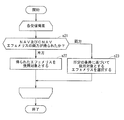
- FIG. 4 shows a second operation example of the navigation message processing unit 5 when the navigation message processing unit 5 determines an ephemeris to be used in the calculation unit 6.
- the navigation message processing unit 5 determines an ephemeris to be used in the calculation unit 6.
- the acquired ephemeris is used, and the NAV ephemeris and the CNAV ephemeris are acquired. If it is, the ephemeris to be used is selected from the NAV ephemeris and the CNAV ephemeris based on a predetermined condition.
- the navigation message processing unit 5 determines whether both the NAV ephemeris and the CNAV ephemeris have been acquired by the navigation message acquisition unit 3 for the target reception satellite in step s21. If it is determined in step s21 that only one of the NAV ephemeris and the CNAV ephemeris has been acquired, in step s22, the acquired one ephemeris is output to the calculation unit 6 as a target of use.
- step s21 if it is determined in step s21 that both the NAV ephemeris and the CNAV ephemeris have been acquired by the navigation message acquisition unit 3, the navigation message processing unit 5 acquires the acquired NAV ephemeris and CNAV ephemeris in step s23. Then, based on a predetermined condition, one ephemeris to be used is selected and output to the calculation unit 6.
- step s23 the navigation message processing unit 5 selects the more accurate of the acquired NAV ephemeris and CNAV ephemeris.
- CNAV ephemeris has more information and better accuracy than NAV ephemeris. Therefore, when both the NAV ephemeris and the CNAV ephemeris are received, the navigation message processing unit 5 sets the CNAV ephemeris to be used.
- the navigation message processing unit 5 may use the latest information of the acquired NAV ephemeris and CNAV ephemeris. Since each of the NAV ephemeris and the CNAV ephemeris includes reference time information indicating the time when the ephemeris is generated, the navigation message processing unit 5 compares the reference time information of the NAV ephemeris and the CNAV ephemeris. Can identify the latest information.
- the navigation message processing unit 5 may use the most reliable one of the acquired NAV ephemeris and CNAV ephemeris.
- Each of the NAV message and the CNAV message includes health information indicating whether or not the operation of the GPS satellite that transmits the navigation message is normal.
- the navigation message processing unit 5 refers to the health information of the NAV message and the CNAV message acquired by the navigation message acquisition unit 3, and confirms the operation status of the GPS satellite when each navigation message is transmitted. Then, the navigation message processing unit 5 determines that the operation of the GPS satellite when the NAV message is transmitted and the operation of the GPS satellite when the CNAV message is transmitted is abnormal.
- the navigation message processing unit 5 performs the CNAV ephemeris. Is determined to be more reliable than the NAV ephemeris, and the CNAV ephemeris is used.
- the navigation message processing unit 5 uses the predetermined one of the NAV ephemeris and the CNAV ephemeris when the operation of the GPS satellite is normal when the NAV message and the CNAV message are transmitted. When both are abnormal, neither the NAV ephemeris nor the CNAV ephemeris is used.
- the navigation message processing unit 5 may use the ephemeris designated by the user from the received NAV ephemeris and CNAV ephemeris. In this case, the navigation message processing unit 5 selects the user when both the NAV ephemeris and the CNAV ephemeris are acquired using the external device connected to the data communication unit 7 of the GNSS receiving device 100. Enable to set ephemeris.
- the navigation message processing unit 5 uses NAV ephemeris and CNAV ephemeris that is designated by the user through the data communication unit 7 as a target of use.
- the navigation message processing unit 5 performs the above steps s21 to s23 each time a new ephemeris is obtained for each receiving satellite.
- FIG. 5 is a flowchart showing a second operation example of the navigation message processing unit 5 when the navigation message processing unit 5 determines an ionosphere parameter to be used in the calculation unit 6.
- the navigation message processing unit 5 determines whether or not both the NAV ionosphere parameter and the CNAV ionosphere parameter have been acquired by the navigation message acquisition unit 3 for the target reception satellite in step s31. If it is determined in step s31 that only one of the NAV ionosphere parameter and the CNAV ionosphere parameter has been acquired, the navigation message processing unit 5 outputs the acquired one to the computing unit 6 as a use target in step s32.
- step s31 when it is determined in step s31 that both the NAV ionosphere parameter and the CNAV ionosphere parameter are obtained by the navigation message acquisition unit 3, the navigation message processing unit 5 obtains the NAV ionosphere parameter obtained in step s33. Then, one ionosphere parameter to be used is selected from the CNAV ionosphere parameters based on a predetermined condition, and is output to the calculation unit 6.
- the selection condition in step s33 the same condition as the selection condition in step s33 described above can be adopted.
- the CNAV ionosphere parameter has a larger amount of information and is more accurate than the NAV ionosphere parameter. Therefore, in step s33, when the most accurate parameter of both ionosphere parameters is used, the CNAV ionosphere parameter is used. It is said.
- the navigation message processing unit 5 performs the same processing when a new ionosphere parameter is received by the receiving unit 1 for the target reception satellite, and outputs the ionosphere parameter to be used to the calculation unit 6.
- the navigation message processing unit 5 also performs the same processing when the ionosphere parameter from another receiving satellite is received by the reception unit 1, and outputs the ionosphere parameter to be used to the calculation unit 6.
- the UTC parameter to be used in the calculation unit 6 can be determined in the same manner as the ionosphere parameter.
- the CNAV-UTC parameter has a larger amount of information and is more accurate than the NAV-UTC parameter. Therefore, when both the NAV-UTC parameter and the CNAV-UTC parameter are received, the one with better accuracy is used. , CNAV-UTC parameters are used.
- the almanac to be used in the calculation unit 6 can be determined in the same manner as the ionospheric parameters.
- the navigation message processing unit 5 stores the same type of information in the NAV message and the CNAV message acquired by the navigation message acquisition unit 3. Since any one of them is output, the calculation unit 6 can perform calculation based on appropriate information of the same type of information.
- the navigation message processing unit 5 outputs the latest ephemeris among the NAV ephemeris and the CNAV ephemeris, so that the calculation unit 6 can obtain the position of the receiving satellite using the latest ephemeris. . Therefore, the position of the receiving satellite can be accurately obtained, and as a result, the position of the GNSS receiving apparatus 100 and the GPS time can be accurately obtained.
- the calculating part 6 can obtain
- the calculating part 6 require UTC time using the newest UTC parameter, it can obtain exact UTC time.
- the navigation message processing unit 5 uses another navigation message different from the navigation message including the predetermined information acquired by the navigation message acquisition unit 3.
- the navigation message acquisition unit 3 does not acquire the same type of information that is included, the navigation message acquisition unit 3 outputs the predetermined information.
- the receiving unit 1 receives only one type of GPS signal
- the navigation message processing unit 5 outputs predetermined information included in the one type of GPS signal acquired by the navigation message acquiring unit 3. ing. Therefore, regardless of which navigation message includes the predetermined information acquired by the navigation message acquisition unit 3, the calculation unit 6 can perform an operation based on the predetermined information. Therefore, the calculation result in the calculating part 6 can be obtained immediately, and the performance of this GNSS receiver 100 is improved.
- the plurality of types of signals are transmitted in the same manner as in the flowcharts of FIGS.
- a plurality of information of the same type included in a plurality of types of navigation messages respectively superimposed on the signal is acquired by the navigation message acquisition unit 3, an operation is performed based on a predetermined condition from the plurality of information of the same type
- the calculation unit 6 can perform a predetermined calculation using appropriate information.
- the information to be used is included in which type of navigation message by making the acquired information to be used. Regardless, the calculation unit 6 can perform calculation using the information. Therefore, the calculation result in the calculation unit 6 can be obtained immediately.
- FIG. 6 is a flowchart showing a first operation example of the pseudo distance processing unit 4.
- the acquisition tracking unit 2 of the L1 observation data and the L2 observation data regardless of whether both L1 observation data and L2 observation data are obtained or only one of them is obtained for each receiving satellite, the acquisition tracking unit 2 of the L1 observation data and the L2 observation data.
- the pseudo distance included in the observation data obtained first is set as the pseudo distance used in the positioning calculation.
- the pseudorange processing unit 4 first obtains observation data (for example, L1 observation data) obtained by the acquisition tracking unit 2 among the L1 observation data and the L2 observation data for the target reception satellite in step s41.
- the pseudo distance included in is used.
- the pseudo distance processing unit 4 performs carrier smoothing on the pseudo distance included in the observation data obtained first, that is, the pseudo distance of the use target, using the ADR included in the observation data. Do. Then, the pseudo distance processing unit 4 outputs the pseudo distance after the carrier smoothing to the calculation unit 6.
- the pseudo distance processing unit 4 does not set the observation data as a use target in step s44. , It is not output to the arithmetic unit 6. Thereafter, the pseudo distance processing unit 4 ends the process for the target reception satellite.
- the pseudo distance processing unit 4 ends the process for the target reception satellite even when the second observation data for the target reception satellite cannot be obtained in step s43.
- the pseudo-range processing unit 4 performs the processing of the above steps s41 to s44 every time new observation data is obtained for each receiving satellite.
- the calculation unit 6 obtains the ionospheric delay amount using the ionospheric delay parameter input from the navigation message processing unit 5.
- the ionospheric delay parameter is determined based on a model indicating the ionospheric delay called the “Klobuchar model”.
- the calculation unit 6 corrects each pseudo distance input from the pseudo distance processing unit 4 using the obtained ionospheric delay amount, and eliminates the influence of the ionospheric delay from each pseudo distance. Thereafter, the calculation unit 6 performs positioning calculation using each corrected pseudo distance.
- the pseudorange included in the observation data obtained first is the target for use in the positioning calculation, so only the L1C / A signal is received.
- pseudoranges for four satellites can be obtained immediately.
- the position of the GNSS receiver 100 and the GPS time can be obtained immediately.
- the L1 observation data can be acquired for only two satellites, only the pseudorange for two satellites can be obtained, so that the positioning calculation cannot be performed.
- the pseudo distance for four satellites can be obtained. Arithmetic can be performed. Therefore, the position and GPS time of the GNSS receiver 100 can be acquired immediately, and the time until the position and GPS time of the GNSS receiver 100 can be obtained, such as TTFF (Time (To First Fix), can be shortened. Therefore, the performance of the GNSS receiver 100 is improved.
- TTFF Time (To First Fix
- the pseudo-range processing unit 4 does not execute step s2 for each received satellite, but directly inputs the pseudo-range obtained by the acquisition and tracking unit 2 to the calculation unit 6 as it is to be used. Become.
- the pseudo distance may be a pseudo distance used in the positioning calculation.
- FIG. 7 is a flowchart showing a second operation example of the pseudo distance processing unit 4.
- the pseudorange included in the obtained observation data is used as the object of use, and the L1 observation data and the L2 observation data are used. Is obtained, one pseudo distance to be used is selected based on a predetermined condition from the pseudo distances included in the L1 observation data and the L2 observation data.
- the pseudo distance processing unit 4 determines whether both the L1 observation data and the L2 observation data are obtained by the acquisition tracking unit 2 for the target reception satellite in step s51. When it is determined in step s51 that only one of the L1 observation data and the L2 observation data is obtained, the pseudo distance processing unit 4 uses the pseudo distance included in the obtained one observation data in step s52. And In step s53, the pseudo distance processing unit 4 performs carrier smoothing on the pseudo distance included in the obtained observation data, that is, the pseudo distance to be used, using the ADR included in the observation data. The pseudo distance after the carrier smoothing is input to the calculation unit 6.
- the pseudorange processing unit 4 obtains the L1 observation data and the L2 observation obtained in step s54.
- Carrier smoothing is performed for each pseudo distance included in the data. Specifically, the pseudo distance processing unit 4 performs carrier smoothing on the pseudo distance included in the L1 observation data using the ADR included in the L1 observation data, and converts the pseudo distance to the pseudo distance included in the L2 observation data.
- carrier smoothing is performed using the ADR included in the L2 observation data.
- the pseudo distance processing unit 4 is obtained from the pseudo distance after carrier smoothing obtained from the L1 observation data (hereinafter referred to as “corrected L1 pseudo distance”) and the L2 observation data. From the pseudo distance after the carrier smoothing (hereinafter referred to as “corrected L2 pseudo distance”), the pseudo distance to be used is selected based on a predetermined condition. Then, the pseudo distance processing unit 4 outputs the pseudo distance selected as the use target to the calculation unit 6.
- the pseudo distance processing unit 4 corrects the corrected L1 pseudo distance and the corrected value based on the reception level of the L1C / A signal at the reception unit 1 and the reception level of the L2C signal at the reception unit 1.
- the pseudo distance to be used is selected from the L2 pseudo distance.
- the pseudo-range processing unit 4 receives the reception level of the L1C / A signal and the L2C signal transmitted by the target reception satellite at the reception unit 1 (for example, C / N0 (carrier-to-noise density ratio)). ).
- the reception level of the L1C / A signal at the reception unit 1 is obtained from the L1 baseband signal at the L1 acquisition / tracking unit 20, and the reception level of the L2C signal at the reception unit 1 is calculated at the L2 acquisition / tracking unit 21. It is requested from.
- the pseudo distance processing unit 4 uses the corrected L1 pseudo distance when the reception level of the L1C / A signal is higher, and uses the corrected L2 pseudo distance when the reception level of the L2C signal is higher. Is intended for use. Then, when the reception levels of the L1C / A signal and the L2C signal are the same, the pseudo distance processing unit 4 uses a predetermined pseudo distance (for example, the corrected L1 pseudo distance) as a target of use. .
- the pseudo distance processing unit 4 may use the pseudo distance specified by the user among the corrected L1 pseudo distance and the corrected L2 pseudo distance. In this case, when the user acquires both the corrected L1 pseudo distance and the corrected L2 pseudo distance using the external device connected to the data communication unit 7 of the GNSS receiving apparatus 100.
- the pseudo distance selected by the pseudo distance processing unit 4 can be set.
- the pseudo distance processing unit 4 uses the pseudo distance specified by the user through the data communication unit 7 among the corrected L1 pseudo distance and the corrected L2 pseudo distance.
- the GNSS receiver 100 includes a receiving circuit that receives a signal from a geostationary satellite of SBAS (Satellite-Based Augmentation System) such as WAAS (Wide Area Augmentation System), step s55
- the pseudo distance processing unit 4 may select one of the corrected L1 pseudo distance and the corrected L2 pseudo distance based on the SBAS signal received by the receiving circuit. For example, when correction information about the pseudorange of the L1 observation data is sent from a SBAS geostationary satellite for a certain receiving satellite, the pseudorange processing unit 4 corrects it as a target to be used for the receiving satellite. Choose the L1 pseudorange.
- the pseudo distance processing unit 4 corrects it as an object to be used for the receiving satellite. Select a later L2 pseudorange. Then, the pseudo distance processing unit 4 corrects the selected pseudo distance again based on the correction information from the SBAS, and outputs the corrected pseudo distance to the calculation unit 6.
- the pseudo-range processing unit 4 performs the above steps s51 to s55 every time new observation data is obtained for each receiving satellite.
- the calculation unit 6 obtains the ionospheric delay amount using the ionosphere parameters as described above. And the calculating part 6 correct
- the pseudo distance to be used is selected based on a predetermined condition from the pseudo distances included in the L1 observation data and the L2 observation data. Has been. Therefore, the positioning calculation can be performed using an appropriate pseudo distance among the pseudo distances included in the L1 observation data and the L2 observation data.
- the pseudo distance included in the acquired one observation data is used as the target of use, so that the L1 observation data and L2 Regardless of the observation data, the pseudo distance of the obtained observation data can be used for the positioning calculation. Therefore, pseudo distances for four satellites can be obtained immediately, and the position and GPS time of the GNSS receiver 100 can be obtained immediately. As a result, the performance of the GNSS receiver 100 is improved.
- the reception levels of the L1C / A signal and the L2C signal transmitted from the receiving satellite are determined from their pseudoranges. Based on the selection of the pseudo distance to be used, the positioning calculation can be performed using the pseudo distance obtained from the GPS signal having a good reception state. Therefore, the position of the GNSS receiver 100 and the GPS time can be obtained using the pseudo distance with high accuracy, and the accuracy of the position of the GNSS receiver 100 and the GPS time is improved.
- steps s53 and s54 are not executed, and a pseudo distance for which carrier smoothing is not performed is input to the calculation unit 6.
- FIG. 8 is a flowchart showing a third operation example of the pseudo distance processing unit 4.
- the pseudo distance of the obtained observation data is used as the object to be obtained, and the L1 observation data and the L2 observation data are obtained. If so, a weighted average value of those pseudo distances is obtained, and the obtained weighted average value is set as a pseudo distance to be used.
- the pseudorange processing unit 4 determines whether both the L1 observation data and the L2 observation data are obtained by the acquisition tracking unit 2 for the target reception satellite in Step s61.
- the pseudo distance processing unit 4 uses the pseudo distance included in the obtained one observation data as a target of use.
- the pseudo distance processing unit 4 performs carrier smoothing on the pseudo distance included in the obtained observation data, that is, the pseudo distance to be used, using the ADR included in the observation data. The pseudo distance after the carrier smoothing is input to the calculation unit 6.
- the pseudorange processing unit 4 obtains the L1 observation data and the L2 observation obtained in step s64.
- Carrier smoothing is performed for each pseudo distance included in the data.
- the pseudo distance processing unit 4 performs carrier smoothing on the pseudo distance included in the L1 observation data using the ADR included in the L1 observation data, and converts the pseudo distance to the pseudo distance included in the L2 observation data.
- carrier smoothing is performed using the ADR included in the L2 observation data.
- the pseudo distance processing unit 4 obtains a weighted average value of the corrected L1 pseudo distance and the corrected L2 pseudo distance. Specifically, the pseudo distance processing unit 4 sets the reception level of the GPS signal (L1C / A signal or L2C signal) corresponding to each of the corrected L1 pseudo distance and the corrected L2 pseudo distance. Accordingly, weighting is performed, and an average value of both pseudo distances after weighting is obtained. For example, when the reception level of the L1C / A signal is larger than the reception level of the L2C signal, the weight set for the corrected L1 pseudo distance is set larger than the weight set for the corrected L2 pseudo distance, An average value of both pseudo distances after weighting is obtained. In step s66, the pseudo distance processing unit 4 inputs the weighted average value obtained in step s65 to the calculation unit 6 as a pseudo distance to be used.
- the pseudo distance processing unit 4 inputs the weighted average value obtained in step s65 to the calculation unit 6 as a pseudo distance to be used.
- the pseudo-range processing unit 4 performs the above-described processing of steps s61 to s66 every time new observation data is obtained for each receiving satellite.
- the calculation unit 6 obtains the ionospheric delay amount using the ionosphere parameters as described above. And the calculating part 6 correct
- the weighted average value of the pseudoranges of the L1 observation data and the L2 observation data is used. It is possible to perform positioning calculation using a pseudo distance with less. Therefore, it is possible to obtain the position of the GNSS receiver 100 and the GPS time using an accurate pseudorange. As a result, the accuracy of the position of the GNSS receiver 100 and the GPS time is improved.
- the L1 observation data and the L2 observation data are obtained by using the pseudo distance of the acquired one observation data as a target of use. Regardless of the case, the pseudo distance of the obtained observation data can be used for the positioning calculation. Therefore, pseudo distances for four satellites can be obtained immediately, and the position and GPS time of the GNSS receiver 100 can be obtained immediately. As a result, the performance of the GNSS receiver 100 is improved.
- steps s63 and s64 are not executed, and a pseudo distance for which carrier smoothing is not performed is input to the calculation unit 6.
- the weighted average value of the pseudo distances of the plurality of observation data may be used as one pseudo distance of the use object.
- FIG. 9 is a flowchart showing a fourth operation example of the pseudo distance processing unit 4.
- the pseudorange obtained by using the ionosphere-free linear combination and excluding the influence of the ionosphere delay is referred to as “ionosphere-free pseudorange”.
- the ionosphere-free pseudorange is obtained by using two pseudoranges obtained from two types of radio signals transmitted from the same GPS satellite and having different carrier frequencies.
- the ionosphere-free pseudorange rt is obtained by the following formula (1).
- f1 and f2 indicate the carrier frequencies of the L1C / A signal and the L2C signal, that is, the L1 frequency and the L2 frequency, respectively.
- R1 represents a pseudorange affected by the ionospheric delay obtained from the L1C / A signal
- r2 represents a pseudodistance affected by the ionospheric delay obtained from the L2C signal.
- the ionosphere delay amount is obtained using the ionosphere parameters included in the navigation message from the GPS satellite, and the ionosphere delay amount is used to obtain the L1C / A signal or the L2C signal.
- the pseudo distance corrected in this way is called a “model corrected pseudo distance”.
- ionosphere-free pseudoranges When using ionosphere-free pseudoranges, positioning accuracy and time accuracy may deteriorate if ionosphere-free pseudoranges and model correction pseudoranges are used in combination. It is necessary that all pseudoranges for four satellites or more used in the above are ionosphere-free pseudoranges.
- step s71 the pseudorange processing unit 4 checks whether both the L1 observation data and the L2 observation data are obtained by the acquisition tracking unit 2 for each reception satellite.
- step s72 the pseudo-range processing unit 4 executes step s73 when there are four or more receiving satellites from which both the L1 observation data and the L2 observation data are obtained, and when the number is less than four, Executes step s75.
- step s73 for each receiving satellite from which both the L1 observation data and the L2 observation data are obtained, the pseudorange processing unit 4 calculates the ADR included in the L1 observation data with respect to the pseudorange included in the L1 observation data.
- the carrier smoothing is performed using the ADR included in the L2 observation data, and the carrier smoothing is performed on the pseudo distance included in the L2 observation data.
- step s74 the pseudorange processing unit 4 sets the corrected L1 pseudorange to r1 in the equation (1) for each received satellite from which both the L1 observation data and the L2 observation data are obtained, and after the correction.
- the ionosphere-free pseudorange rt is obtained by setting the L2 pseudorange to r2 in the formula (1).
- step s74 ionosphere-free pseudoranges for four satellites or more are obtained. These ionosphere-free pseudoranges are input to the calculation unit 6 as objects to be used in the positioning calculation. When the ionosphere-free pseudo distance for four satellites or more is input from the pseudo distance processing unit 4, the arithmetic unit 6 performs positioning calculation using them.
- the pseudorange processing unit 4 performs carrier smoothing on the pseudorange included in the obtained observation data for each received satellite. For example, when only one observation data of the L1 observation data and the L2 observation data is obtained by the acquisition tracking unit 2 for a certain receiving satellite, the pseudo distance processing unit 4 includes the pseudo data included in the observation data. Carrier smoothing is performed on the distance using the ADR included in the observation data. Further, when both the L1 observation data and the two observation data are obtained by the acquisition and tracking unit 2 for a certain receiving satellite, the pseudorange processing unit 4 performs the following operation on the pseudorange included in the L1 observation data.
- Carrier smoothing is performed using the ADR included in the L1 observation data, and carrier smoothing is performed using the ADR included in the L2 observation data for the pseudo distance included in the L2 observation data.
- step s75 at least one of the corrected L1 pseudorange and the corrected L2 pseudorange is obtained for each receiving satellite.
- the pseudo-range processing unit 4 uses, for each received satellite, either the corrected L1 pseudo-range or the corrected L2 pseudo-range in the positioning calculation. For example, if only one of the corrected L1 pseudorange and the corrected L2 pseudorange is obtained for a certain receiving satellite, the obtained pseudorange is used. Further, when both the corrected L1 pseudorange and the corrected L2 pseudorange are obtained for a certain receiving satellite, the same as in step s55 of the second operation example described above, A pseudo distance to be used is selected based on a predetermined condition from the L1 pseudo distance and the corrected L2 pseudo distance. Then, the pseudo distance processing unit 4 outputs the pseudo distance to be used to the calculation unit 6.
- the pseudo distance input to the calculation unit 6 is a pseudo distance affected by the ionospheric delay.
- the calculation unit 6 obtains the ionospheric delay amount using the ionosphere parameters as described above. And the calculating part 6 correct
- the pseudo distance processing unit 4 repeats the above steps s71 to s76 at predetermined intervals.
- the pseudorange processing unit 4 performs the same operation as that in the second operation example described above. Therefore, the same effect as in the second operation example can be obtained.
- the ionosphere-free pseudorange is used for the positioning calculation. Will improve.
- one of the L1 observation data and the L2 observation data is related to each reception satellite as in the third operation example described above.
- the pseudo distance of the obtained observation data is used, and when L1 observation data and L2 observation data are obtained, a weighted average value of those pseudo distances is obtained and obtained.
- the weighted average value may be used as the pseudo distance of the object to be used. Thereby, the same effect as the third operation example can be obtained.
- step s73 is not executed, and the ionosphere-free pseudorange obtained using the pseudorange for which carrier smoothing is not performed is input to the calculation unit 6. Further, the pseudo distance for which carrier smoothing is not performed is input to the calculation unit 6 without executing step s75.
- the pseudo distance used in the calculation unit 6 can be obtained in the same manner. That is, when the number of receiving satellites from which a plurality of observation data is obtained is less than four, the model-corrected pseudorange is used as the pseudorange used by the calculation unit 6, and four or more receiving satellites from which a plurality of observation data are obtained are obtained. In this case, the ionosphere-free pseudo distance is set as a pseudo distance used in the calculation unit 6.
- the present invention can also be applied to other GNSS receivers such as GALILEO and GLONASS.
- GALILEO two types of navigation messages of I / NAV message and F / NAV message are used. It is possible to determine which information is to be used.
- the present invention can be similarly applied to information other than the ephemeris, almanac, ionosphere parameter, and UTC parameter included in the navigation message.
Landscapes
- Engineering & Computer Science (AREA)
- Radar, Positioning & Navigation (AREA)
- Remote Sensing (AREA)
- Computer Networks & Wireless Communication (AREA)
- Physics & Mathematics (AREA)
- General Physics & Mathematics (AREA)
- Position Fixing By Use Of Radio Waves (AREA)
Abstract
Description
図1は本実施の形態に係るGNSS受信装置100の構成を示す図である。本実施の形態に係るGNSS受信装置100は、例えば、GPSにおいて衛星からの信号を受信するGPS受信装置である。本実施の形態に係るGNSS受信装置100は、GPS衛星からの受信信号に基づいて自装置の位置とUTC(Universal Time, Coordinated)時刻を求めて出力する。
次に、航法メッセージ処理部5の動作について詳細に説明する。以下に、航法メッセージ処理部5の複数の動作例について説明する。以後、説明の対象の一の受信衛星を「対象受信衛星」と呼ぶ。
図2は、航法メッセージ処理部5が、演算部6での使用対象となるエフェメリスを決定する際の当該航法メッセージ処理部5の第1の動作例を示している。本動作例では、各受信衛星に関して、航法メッセージ取得部3でNAVエフェメリス及びCNAVエフェメリスの両方が取得されるか、それらのうちの一方だけが取得されるかにかかわらず、それらのうちの航法メッセージ取得部3で最初に取得されたエフェメリスを使用対象とする。
図4は航法メッセージ処理部5が、演算部6での使用対象となるエフェメリスを決定する際の当該航法メッセージ処理部5の第2の動作例を示している。本動作例では、各受信衛星に関して、航法メッセージ取得部3において、NAVエフェメリス及びCNAVエフェメリスのどちらか一方が取得された場合には、取得されたエフェメリスを使用対象とし、NAVエフェメリス及びCNAVエフェメリスが取得された場合には、NAVエフェメリス及びCNAVエフェメリスから所定の条件に基づいて使用対象のエフェメリスを選択する。
次に、疑似距離処理部4の動作について詳細に説明する。以下に、疑似距離処理部4の複数の動作例について説明する。
図6は疑似距離処理部4の第1の動作例を示すフローチャートである。本動作例では、各受信衛星に関して、L1観測データ及びL2観測データの両方が得られるか、それらの一方だけが得られるかにかかわず、L1観測データ及びL2観測データのうち捕捉追尾部2で最初に得られる観測データに含まれる疑似距離を測位演算で使用する疑似距離とする。
図7は疑似距離処理部4の第2の動作例を示すフローチャートである。本動作例では、各受信衛星に関して、L1観測データ及びL2観測データの一つしか得られない場合には、得られた観測データに含まれる疑似距離を使用対象とし、L1観測データ及びL2観測データが得られた場合には、L1観測データ及びL2観測データに含まれる疑似距離から所定の条件に基づいて使用対象の一の疑似距離を選択する。
図8は疑似距離処理部4の第3の動作例を示すフローチャートである。本動作例では、各受信衛星に関して、L1観測データ及びL2観測データの一つしか得られない場合には、得られた観測データの疑似距離を使用対象とし、L1観測データ及びL2観測データが得られた場合には、それらの疑似距離の重み付け平均値を求め、求めた重み付け平均値を使用対象の疑似距離とする。
図9は疑似距離処理部4の第4の動作例を示すフローチャートである。
ただし、f1及びf2は、L1C/A信号及びL2C信号のキャリア周波数、つまりL1周波数及びL2周波数をそれぞれ示している。また、r1はL1C/A信号から得られる、電離層遅延の影響を受けた疑似距離を示し、r2はL2C信号から得られる、電離層遅延の影響を受けた疑似距離を示している。
3 航法メッセージ取得部
5 航法メッセージ処理部
6 演算部
100 GNSS受信装置
Claims (8)
- GNSS衛星から送信される、互いに異なる航法メッセージが重畳された少なくとも二種類の信号を受信可能なGNSS受信装置において、
前記信号を受信する受信部と、
前記受信した信号に含まれる、前記航法メッセージ内の所定の情報を取得する航法メッセージ取得部と、
前記航法メッセージ取得部で取得される、前記異なる航法メッセージ内の同種類の情報のうちのいずれかを出力する航法メッセージ処理部と、
前記出力された情報に基づいて演算を行う演算部と、
を備えることを特徴とするGNSS受信装置。 - 請求項1に記載のGNSS受信装置であって、
前記航法メッセージ処理部は、前記同種類の情報のうち最初に取得された情報、最新の情報、最も精度がよい情報、あるいは最も信頼性の高い情報を出力する、ことを特徴とするGNSS受信装置。 - 請求項1に記載のGNSS受信装置であって、
前記航法メッセージ処理部は、前記同種類の情報のうち最新の情報、最も精度がよい情報、および最も信頼性の高い情報に基づいて前記航法メッセージに含まれる情報を出力する、ことを特徴とするGNSS受信装置。 - 請求項1に記載のGNSS受信装置であって、
前記航法メッセージ処理部は、前記同種類の情報のうちユーザが指定する情報を出力する、ことを特徴とするGNSS受信装置。 - 請求項1に記載のGNSS受信装置であって、
前記異なる航法メッセージは、NAVメッセージとCNAVメッセージであり、
前記航法メッセージ処理部は、前記同種類の情報のうちCNAVメッセージに含まれる情報を出力する、ことを特徴とするGNSS受信装置。 - 請求項1乃至請求項5のいずれかに記載のGNSS受信装置であって、
前記同種類の情報は、エフェメリス、アルマナック、電離層パラメータ、あるいはUTCパラメータである、ことを特徴とするGNSS受信装置。 - GNSS衛星から送信される、互いに異なる航法メッセージが重畳された少なくとも二種類の信号を受信可能なGNSS受信装置において、
前記信号を受信する受信部と、
前記受信した信号に含まれる、前記航法メッセージ内の所定の情報を取得する航法メッセージ取得部と、
前記航法メッセージ取得部が取得した前記所定の情報が含まれる航法メッセージとは異なる他の航法メッセージに含まれる、当該所定の情報と同種類の情報が前記航法メッセージ取得部で取得されない場合に、前記航法メッセージ取得部が取得した前記所定の情報を出力する航法メッセージ処理部と、
前記出力された情報に基づいて演算を行う演算部と、
を備えることを特徴とするGNSS受信装置。 - GNSS衛星から送信される、互いに異なる航法メッセージが重畳された少なくとも二種類の信号を受信可能なGNSS受信装置において、
前記信号を受信する受信部と、
前記受信した信号に含まれる、前記航法メッセージ内の所定の情報を取得する航法メッセージ取得部と、
前記受信部が一種類の信号のみを受信した場合に、前記航法メッセージ取得部が取得した前記所定の情報を出力する航法メッセージ処理部と、
前記出力された情報に基づいて演算を行う演算部と、
を備えることを特徴とするGNSS受信装置。
Priority Applications (2)
| Application Number | Priority Date | Filing Date | Title |
|---|---|---|---|
| US13/375,665 US8736489B2 (en) | 2009-06-02 | 2010-05-27 | GNSS receiver |
| JP2011518416A JP5683461B2 (ja) | 2009-06-02 | 2010-05-27 | Gnss受信装置 |
Applications Claiming Priority (2)
| Application Number | Priority Date | Filing Date | Title |
|---|---|---|---|
| JP2009-132989 | 2009-06-02 | ||
| JP2009132989 | 2009-06-02 |
Publications (1)
| Publication Number | Publication Date |
|---|---|
| WO2010140528A1 true WO2010140528A1 (ja) | 2010-12-09 |
Family
ID=43297664
Family Applications (1)
| Application Number | Title | Priority Date | Filing Date |
|---|---|---|---|
| PCT/JP2010/058982 Ceased WO2010140528A1 (ja) | 2009-06-02 | 2010-05-27 | Gnss受信装置 |
Country Status (3)
| Country | Link |
|---|---|
| US (1) | US8736489B2 (ja) |
| JP (1) | JP5683461B2 (ja) |
| WO (1) | WO2010140528A1 (ja) |
Cited By (4)
| Publication number | Priority date | Publication date | Assignee | Title |
|---|---|---|---|---|
| JP2015025671A (ja) * | 2013-07-24 | 2015-02-05 | 古野電気株式会社 | 状態算出装置、移動体、状態算出方法、および状態算出プログラム |
| US9543123B2 (en) | 2011-03-31 | 2017-01-10 | Tokyo Electronics Limited | Plasma processing apparatus and plasma generation antenna |
| JP2022177755A (ja) * | 2021-05-18 | 2022-12-01 | 京セラ株式会社 | プロセッサ、移動機、及び電子機器 |
| JP2022190690A (ja) * | 2021-06-14 | 2022-12-26 | ローベルト ボツシユ ゲゼルシヤフト ミツト ベシユレンクテル ハフツング | エフェメリスデータの妥当性検査を伴う、車両のgnssに基づく位置特定方法 |
Families Citing this family (2)
| Publication number | Priority date | Publication date | Assignee | Title |
|---|---|---|---|---|
| EP3355079B8 (en) | 2017-01-25 | 2023-06-21 | Airbus Defence and Space GmbH | Method for each of a plurality of satellites of a secondary global navigation satellite system in a low earth orbit |
| US10768311B2 (en) * | 2017-12-27 | 2020-09-08 | Samsung Electronics Co., Ltd | System and method for combining signals for improved performance in challenging environment |
Citations (3)
| Publication number | Priority date | Publication date | Assignee | Title |
|---|---|---|---|---|
| JP2002071779A (ja) * | 2000-08-29 | 2002-03-12 | Furuno Electric Co Ltd | コンパス |
| JP2005265476A (ja) * | 2004-03-16 | 2005-09-29 | Japan Radio Co Ltd | 衛星航法装置 |
| US20080228398A1 (en) * | 2006-11-03 | 2008-09-18 | Jyri Syrjarinne | Timed-based ephemeris identity in assistance data and assistance data request messages |
Family Cites Families (5)
| Publication number | Priority date | Publication date | Assignee | Title |
|---|---|---|---|---|
| JP3520409B2 (ja) * | 1999-10-07 | 2004-04-19 | セイコーエプソン株式会社 | 現在地測位システムおよび現在地測位方法 |
| JP5165846B2 (ja) | 2006-01-16 | 2013-03-21 | 古野電気株式会社 | 測位用演算装置及び電離層遅延量算出方法 |
| JP2008051567A (ja) | 2006-08-23 | 2008-03-06 | Japan Radio Co Ltd | 衛星航法装置 |
| JP2008286753A (ja) * | 2007-05-21 | 2008-11-27 | Panasonic Corp | 測位装置及びその制御方法 |
| JP5012347B2 (ja) * | 2007-09-12 | 2012-08-29 | 日本電気株式会社 | 軌道情報誤り検出装置、航法システム及びそれに用いる軌道情報誤り検知方法 |
-
2010
- 2010-05-27 WO PCT/JP2010/058982 patent/WO2010140528A1/ja not_active Ceased
- 2010-05-27 JP JP2011518416A patent/JP5683461B2/ja not_active Expired - Fee Related
- 2010-05-27 US US13/375,665 patent/US8736489B2/en active Active
Patent Citations (3)
| Publication number | Priority date | Publication date | Assignee | Title |
|---|---|---|---|---|
| JP2002071779A (ja) * | 2000-08-29 | 2002-03-12 | Furuno Electric Co Ltd | コンパス |
| JP2005265476A (ja) * | 2004-03-16 | 2005-09-29 | Japan Radio Co Ltd | 衛星航法装置 |
| US20080228398A1 (en) * | 2006-11-03 | 2008-09-18 | Jyri Syrjarinne | Timed-based ephemeris identity in assistance data and assistance data request messages |
Cited By (5)
| Publication number | Priority date | Publication date | Assignee | Title |
|---|---|---|---|---|
| US9543123B2 (en) | 2011-03-31 | 2017-01-10 | Tokyo Electronics Limited | Plasma processing apparatus and plasma generation antenna |
| JP2015025671A (ja) * | 2013-07-24 | 2015-02-05 | 古野電気株式会社 | 状態算出装置、移動体、状態算出方法、および状態算出プログラム |
| JP2022177755A (ja) * | 2021-05-18 | 2022-12-01 | 京セラ株式会社 | プロセッサ、移動機、及び電子機器 |
| JP7668676B2 (ja) | 2021-05-18 | 2025-04-25 | 京セラ株式会社 | プロセッサ、移動機、及び電子機器 |
| JP2022190690A (ja) * | 2021-06-14 | 2022-12-26 | ローベルト ボツシユ ゲゼルシヤフト ミツト ベシユレンクテル ハフツング | エフェメリスデータの妥当性検査を伴う、車両のgnssに基づく位置特定方法 |
Also Published As
| Publication number | Publication date |
|---|---|
| US20120068885A1 (en) | 2012-03-22 |
| US8736489B2 (en) | 2014-05-27 |
| JP5683461B2 (ja) | 2015-03-11 |
| JPWO2010140528A1 (ja) | 2012-11-15 |
Similar Documents
| Publication | Publication Date | Title |
|---|---|---|
| CN101441259B (zh) | 一种全球定位系统接收机的自辅助跟踪系统及其跟踪方法 | |
| US8044852B2 (en) | Position determination based on hybrid pseudorange solution data | |
| US7535414B2 (en) | Navigational positioning without timing information | |
| JP5683461B2 (ja) | Gnss受信装置 | |
| RU2625819C1 (ru) | Способ вспомогательного захвата в приемнике объединенной навигационной системы | |
| JP5968998B2 (ja) | 測位信号検出方法、測位信号検出プログラム、測位信号受信装置、測位装置および情報機器端末 | |
| WO2004113948A1 (en) | Method and apparatus for locating position of a satellite signal receiver | |
| JP2011522253A (ja) | 相互相関スプール緩和のための装置および方法 | |
| KR20130014447A (ko) | 의사거리 수정을 이용하는 위치 신호의 수신 방법 및 장치 | |
| CN103842846A (zh) | 一种用于低功耗和低成本gnss接收机的系统,方法和计算机程序 | |
| EP3869233B1 (en) | Gnss correlation distortion detection and mitigation | |
| US12585027B2 (en) | Positioning system and method | |
| CN101185008A (zh) | 卫星定位系统中使用距变率量测确认位置的方法和装置 | |
| EP4439127A1 (en) | A method for performing a correction of a ionospheric error affecting pseudo-ranges measurements in a gnss receiver, corresponding receiver apparatus and computer program product | |
| US7479924B2 (en) | False reacquisition mitigation in high sensitivity navigational satellite signal receivers | |
| JP2006349672A (ja) | Gpsr多周計測型電離層遅延補正装置、gpsr多周計測型電離層遅延補正方法及びプログラム | |
| JP4983699B2 (ja) | Gnss測位装置及び方法 | |
| JP2007292610A (ja) | 衛星航法受信機 | |
| Anghileri et al. | Performance evaluation of a multi-frequency GPS/Galileo/SBAS software receiver | |
| CN117872405A (zh) | 对电离层误差执行校正的方法和接收器装置 | |
| JP2001311768A (ja) | マルチパス判定機能付きgpsレシーバ | |
| JP2008076319A (ja) | 衛星信号判定装置 | |
| CN114966757A (zh) | 用于基于gnss定位车辆的方法 | |
| CN118707549A (zh) | 执行电离层误差的校正的方法、以及gnss接收机装置 | |
| KR20250164401A (ko) | 휴대단말 항법위성 수신 장치와 방법 |
Legal Events
| Date | Code | Title | Description |
|---|---|---|---|
| 121 | Ep: the epo has been informed by wipo that ep was designated in this application |
Ref document number: 10783312 Country of ref document: EP Kind code of ref document: A1 |
|
| WWE | Wipo information: entry into national phase |
Ref document number: 2011518416 Country of ref document: JP |
|
| WWE | Wipo information: entry into national phase |
Ref document number: 13375665 Country of ref document: US |
|
| NENP | Non-entry into the national phase |
Ref country code: DE |
|
| 122 | Ep: pct application non-entry in european phase |
Ref document number: 10783312 Country of ref document: EP Kind code of ref document: A1 |