WO2009113181A1 - 表示装置、情報提示方法、情報提示プログラムおよびコンピュータに読み取り可能な記録媒体 - Google Patents
表示装置、情報提示方法、情報提示プログラムおよびコンピュータに読み取り可能な記録媒体 Download PDFInfo
- Publication number
- WO2009113181A1 WO2009113181A1 PCT/JP2008/054822 JP2008054822W WO2009113181A1 WO 2009113181 A1 WO2009113181 A1 WO 2009113181A1 JP 2008054822 W JP2008054822 W JP 2008054822W WO 2009113181 A1 WO2009113181 A1 WO 2009113181A1
- Authority
- WO
- WIPO (PCT)
- Prior art keywords
- mark
- display
- sign
- road
- information
- Prior art date
- Legal status (The legal status is an assumption and is not a legal conclusion. Google has not performed a legal analysis and makes no representation as to the accuracy of the status listed.)
- Ceased
Links
Images


Classifications
-
- G—PHYSICS
- G08—SIGNALLING
- G08G—TRAFFIC CONTROL SYSTEMS
- G08G1/00—Traffic control systems for road vehicles
- G08G1/09—Arrangements for giving variable traffic instructions
- G08G1/0962—Arrangements for giving variable traffic instructions having an indicator mounted inside the vehicle, e.g. giving voice messages
- G08G1/0968—Systems involving transmission of navigation instructions to the vehicle
- G08G1/0969—Systems involving transmission of navigation instructions to the vehicle having a display in the form of a map
-
- G—PHYSICS
- G01—MEASURING; TESTING
- G01C—MEASURING DISTANCES, LEVELS OR BEARINGS; SURVEYING; NAVIGATION; GYROSCOPIC INSTRUMENTS; PHOTOGRAMMETRY OR VIDEOGRAMMETRY
- G01C21/00—Navigation; Navigational instruments not provided for in groups G01C1/00 - G01C19/00
- G01C21/26—Navigation; Navigational instruments not provided for in groups G01C1/00 - G01C19/00 specially adapted for navigation in a road network
-
- G—PHYSICS
- G08—SIGNALLING
- G08G—TRAFFIC CONTROL SYSTEMS
- G08G1/00—Traffic control systems for road vehicles
- G08G1/09—Arrangements for giving variable traffic instructions
- G08G1/0962—Arrangements for giving variable traffic instructions having an indicator mounted inside the vehicle, e.g. giving voice messages
- G08G1/0967—Systems involving transmission of highway information, e.g. weather, speed limits
- G08G1/096733—Systems involving transmission of highway information, e.g. weather, speed limits where a selection of the information might take place
- G08G1/096758—Systems involving transmission of highway information, e.g. weather, speed limits where a selection of the information might take place where no selection takes place on the transmitted or the received information
Definitions
- the present invention relates to a display device that displays information explaining the meaning of a road sign, an information presentation method, an information presentation program, and a computer-readable recording medium.
- a display device that displays information explaining the meaning of a road sign, an information presentation method, an information presentation program, and a computer-readable recording medium.
- the use of the present invention is not limited to the display device, the information presentation method, the information presentation program, and the computer-readable recording medium.
- a display device includes a display control unit that causes a display unit to display a map around an arbitrary point and a sign mark indicating a road sign, and the display Selection means for accepting selection of a sign mark displayed on the means from a user, and information that explains the meaning of the road sign corresponding to the sign mark when the selection means accepts selection of the sign mark being displayed. And presenting means for presenting.
- An information presentation method is an information presentation method in a display device, wherein a display step for displaying a map around an arbitrary point and a sign mark indicating a road sign on the display device, A selection step of accepting selection of a sign mark from the user, and a presentation step of presenting information explaining the meaning of the road sign corresponding to the sign mark when the selection of the mark mark being displayed is accepted It is characterized by that.
- an information presentation program according to the invention of claim 7 causes a computer to execute the information presentation method according to claim 6.
- a computer-readable recording medium according to the invention of claim 8 is characterized in that the information presentation program according to claim 7 is recorded.
- FIG. 1 is a block diagram showing a functional configuration of a display device according to an embodiment of the present invention.
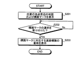
- FIG. 2 is a flowchart showing a processing procedure of the display device according to the present embodiment.
- FIG. 3 is a block diagram illustrating a hardware configuration of the navigation apparatus according to the present embodiment.
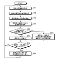
- FIG. 4 is a flowchart showing the processing procedure of the navigation device of this embodiment.
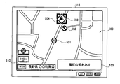
- FIG. 5 is an explanatory diagram (part 1) illustrating a specific display example of the navigation device according to the present embodiment.
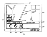
- FIG. 6 is an explanatory diagram (part 2) illustrating a specific display example of the navigation device according to the present embodiment.
- FIG. 1 is a block diagram showing a functional configuration of a display device according to an embodiment of the present invention.
- the display device 100 includes a display unit 101, a display control unit 102, a selection unit 103, and a presentation unit 104.
- the display unit 101 has a function of displaying various images and characters according to the control of the display control unit 102.
- the display unit 101 displays a window, an icon, an image, and the like under the control of the display control unit 102.
- the display unit 101 is realized by a liquid crystal display, a plasma display, or the like.
- the display control unit 102 has a function of controlling the display unit 101 to display a map around an arbitrary point and a sign mark indicating a road sign.
- the arbitrary point is, for example, the current position of the display device 100 or a point designated by the user.
- the sign mark is, for example, an image such as an icon schematically representing various road signs.
- the display control unit 102 causes the display unit 101 to display a sign mark indicating a road sign for the road on or near a road included in a map around an arbitrary point.
- the arbitrary point is not limited to the current position of the display device 100, and may be a point designated by the user of the display device 100, for example.
- the display control unit 102 is realized by causing a computer device to execute a predetermined program prepared in advance.
- the selection unit 103 has a function of accepting a selection from the user for the mark mark displayed on the display unit 101 by the display control unit 102.
- the selection unit 103 receives a selection from the user for an arbitrary mark mark among the mark marks for the road on or near the road included in the map around the arbitrary point displayed on the display unit 101.
- the selection unit 103 is realized by receiving a user's operation through various input devices such as a keyboard and a mouse.
- the presentation unit 104 has a function of presenting information explaining the meaning of the road sign corresponding to the sign mark when the selection unit 103 accepts the selection of the sign mark being displayed on the display unit 101. Specifically, when the presentation unit 104 receives selection of a sign mark currently displayed on the display unit 101 by the selection unit 103 from the user, the presentation unit 104 provides information explaining the meaning of the road sign corresponding to the selected sign mark. Present (for example, present by displaying on the display unit 101).
- the information explaining the meaning of the road sign is, for example, information such as a predetermined character string (description) explaining the meaning of “one-way” (in the direction indicated by the arrow) for the road sign of the one-sided arrow It is.
- the display unit 100 is a character string that explains the meaning of the road sign. “Travel” is presented to the user.
- the presentation unit 104 is realized by displaying a character string explaining the meaning of the road sign using a liquid crystal display, a plasma display, or the like, or outputting a sound explaining the meaning of the road sign using a speaker.
- the display device 100 may include a road detection unit 105.
- the road detection unit 105 when the display device 100 is mounted on a moving body, the road detection unit 105 has a function of detecting a road on which the moving body is moving.
- the display control unit 102 causes the display unit 101 to display a sign mark for the moving road detected by the road detection unit 105.
- the display of the sign mark with respect to the moving road is displayed in a place other than the map displayed on the display unit 101 (for example, displayed in a predetermined window displayed on the display unit 101).
- the display of the mark mark for the moving road may be displayed on the map being displayed on the display unit 101.
- the road detection unit 105 is realized by causing a computer device to execute a predetermined program prepared in advance.
- the display control unit 102 may display a sign mark indicating a road sign peculiar to a region to which an arbitrary point belongs, on the display unit 101 so as to be distinguishable from marks indicating other road signs.
- the road sign peculiar to an area to which an arbitrary point belongs is, for example, due to the characteristics of the area such as ⁇ Caution for jumping out animals '' in areas where there are many wild animals and ⁇ There is a risk of falling rocks '' in mountain areas. , Required signs, etc.
- the display method for distinguishing the mark is, for example, distinguishing the display size of the sign mark by size, distinguishing it by attaching a specific color to the outside of the mark, or displaying the mark in blinking Etc.
- the display control unit 102 may display only a specific type of mark mark on the display unit 101.
- the specific type of sign mark is, for example, a sign mark indicating a road sign peculiar to a region or a road sign having a small number.
- the specific type of mark mark may be a mark mark of a type designated by the user in advance.
- FIG. 2 is a flowchart showing a processing procedure of the display device according to the present embodiment. Note that the flowchart shown in FIG. 2 is started, for example, when the display device 100 is turned on at any timing of the user.
- the display device 100 displays a map around an arbitrary point and a sign mark indicating a road sign (step S201). Specifically, the display device 100 controls the display unit 101 by the display control unit 102 to display a map around an arbitrary point and a sign mark indicating a road sign.
- step S201 after displaying a map around an arbitrary point and a sign mark indicating a road sign, the display device 100 determines whether or not a selection for the displayed sign mark has been received from the user (step S202). Specifically, the display device 100 determines whether the selection unit 103 has received a selection for the mark mark from the user.
- step S202 when it is determined that the selection of the mark mark is not received from the user (step S202: No), the display device 100 waits until the selection of the mark mark is received from the user.
- step S202 when it is determined in step S202 that the selection of the sign mark has been received from the user (step S202: Yes), the display device 100 indicates the meaning of the road sign corresponding to the sign mark that has received the selection from the user. Information to be explained is presented (step S203), and a series of processing ends. Specifically, the display device 100 presents the meaning of the road sign corresponding to the sign mark accepted from the user by the presentation unit 104 and ends the series of processes.
- the selection unit 103 when the selection unit 103 receives a selection from the user for the mark mark displayed on the display unit 101 by the display control unit 102, the mark Information that explains the meaning of the road sign corresponding to the mark can be presented to the presentation unit 104. Therefore, it is possible to know the meaning of the road sign displayed on the display unit 101 and selected by the user. This deepens the user's understanding of road signs and contributes to safe driving when the user drives a moving body such as a vehicle.
- the display control unit 102 can control the display unit 101 so that the mark mark is displayed on or near the road included in the map. Therefore, the user can confirm the road and the road signs near the road in association with each other, and the understanding of the road sign is further deepened.
- the display control unit 102 can display a road sign for the road on which the moving body is moving on the display unit 101. The user can accurately grasp the meaning of the road sign for the moving road, and can improve safety.
- a road sign peculiar to an area at an arbitrary point can be displayed on the display unit 101 separately from other road signs, the user can recognize a road sign peculiar to a certain area or a rare road sign with a small number. It can be made easier.
- a present Example is an example at the time of applying said display apparatus 100 to the navigation apparatus mounted in mobile bodies, such as a vehicle (a four-wheeled vehicle and a two-wheeled vehicle are included), for example.
- FIG. 3 is a block diagram illustrating a hardware configuration of the navigation apparatus according to the present embodiment.
- the navigation apparatus 300 includes a CPU 301, a ROM 302, a RAM 303, a magnetic disk drive 304, a magnetic disk 305, an optical disk drive 306, an optical disk 307, and an audio I / F (interface) 308.
- the respective components 301 to 317 are connected by a bus 320, respectively.
- the CPU 301 governs overall control of the navigation device 300.
- the ROM 302 stores various programs such as a boot program, a current position specifying program, a route search program, a route guidance program, a voice generation program, a map information display program, and a road sign guidance program. In addition to the ROM 302, these various programs may be recorded in a nonvolatile memory such as a magnetic disk 305 and an optical disk 307 described later.
- the RAM 303 is used as a work area for the CPU 301.
- the CPU 301 controls the entire navigation device 300 by executing various programs recorded in the ROM 302 or the like while using the RAM 303 as a work area.
- the current position specifying program specifies the current position of the navigation device 300 based on output information from a GPS unit 316 and various sensors 317 described later.
- the route search program uses the map information recorded on the magnetic disk 305 or the optical disk 307, which will be described later, or the like to obtain an optimum route from the departure point (for example, the current position) to the destination via a predetermined waypoint. Then, a detour route in the case of deviating from the optimum route is searched.
- the predetermined waypoint is a parking lot searched by executing a parking lot search program described later.
- the optimum route is a route with the minimum cost (time required) to the destination or a route that best meets the conditions specified by the user. Since the route search program is a known technique, a detailed description thereof is omitted, but an optimal route is searched using the Dijkstra method or the like. The route information of the route searched by executing the route search program is output to the audio I / F 308 and the video I / F 312 via the CPU 301.
- the route guidance program includes route information of a route searched by executing the route search program, current position information of the current position of the navigation device 300 specified by executing the current position specifying program, the magnetic disk 305 or the optical disk 307. On the basis of the map information read out from, real-time route guidance information is generated.
- the route guidance information generated by executing the route guidance program is output to the audio I / F 308 and the video I / F 312 via the CPU 301.
- the voice generation program generates tone and voice information corresponding to the pattern. That is, based on the route guidance information generated by executing the route guidance program, the virtual sound source corresponding to the guidance point is set and the voice guidance information is generated.
- the voice guidance information includes, for example, an alarm to turn right and left according to the route, a warning to decelerate in front of the right and left turning point, information about a detour route when the right or left fails, Guidance information to the effect that it should be turned back if it fails to turn right or left is included.
- the generated voice guidance information is output to the voice I / F 308 via the CPU 301.
- the map information display program causes the display 313 to display the map information read from the magnetic disk 305 or the optical disk 307 by the video I / F 312.
- the map information display program causes the display 313 to display map information around the current position of the navigation device 300, for example. Further, the map information display program may display map information around an arbitrary position designated by the user on the display 313, for example.
- the road sign guide program guides the meaning of the road sign corresponding to the selected sign mark.
- the road sign guidance program for example, identifies a road sign corresponding to the selected sign mark from the map information, and causes the display 313 to display a predetermined character string (description) preset for each type of the road sign. .
- a predetermined sound set in advance for each type of the road sign is output from the speaker 310.
- the magnetic disk drive 304 controls the reading / writing of the data with respect to the magnetic disk 305 according to control of CPU301. Data written under the control of the magnetic disk drive 304 is recorded on the magnetic disk 305.
- the magnetic disk 305 for example, HD or FD (flexible disk) can be used.
- the optical disc drive 306 controls reading / writing of data with respect to the optical disc 307 according to the control of the CPU 301.
- the optical disk 307 is a detachable recording medium from which data is read according to the control of the optical disk drive 306.
- a CD Compact Disc
- DVD can be used as the optical disc 307.
- a writable recording medium can be used as the optical disc 307.
- the removable recording medium may be an MO (Magneto Optical Disk), a memory card, or the like.
- map information used for route search / route guidance.
- the map information includes background data that represents features (features) such as buildings, rivers, and surface points, and road shape data that represents the shape of the road.
- the map information is displayed two-dimensionally or three-dimensionally on the display screen of the display 313. Drawn.
- the road shape data further has traffic condition data.
- the traffic condition data includes, for example, whether or not there are traffic lights or pedestrian crossings, highway entrances or junctions, length (distance) for each link, road width, direction of travel, road type (highway, Information on toll roads and general roads).
- past traffic information is recorded by statistically processing past traffic information based on seasons, days of the week, large holidays, and times.
- the navigation device 300 obtains information on the currently occurring traffic jam based on road traffic information received by the communication I / F 315, which will be described later, and can predict a traffic jam situation at a specified time based on the past traffic jam information. Become.
- the map information includes information on the sign marks corresponding to the road signs.
- the information of the sign mark is an image such as an icon (sign mark mark) schematically representing various road signs, and a map represented by map information of which type of sign mark among the sign marks. This is information indicating the position on the top.
- the information recorded on the magnetic disk or the optical disk includes sign explanation information.
- the sign explanation information is information such as text data and voice data explaining the meaning of each road sign.
- the sign explanation information is text data representing the character string “pause” that explains the meaning of the road sign, or voice data that outputs a voice “pause”.
- Each sign mark in the map information is associated in advance with the sign explanation information corresponding to the sign mark of the sign explanation information.
- a sign mark corresponding to a temporarily stopped road sign in map information is associated with text data “pause” and voice data “pause” as sign explanation information.
- the map information is recorded on the magnetic disk 305 or the optical disk 307.
- the map information is not recorded only on the one provided integrally with the hardware of the navigation device 300, and may be provided outside the navigation device 300.
- the navigation apparatus 300 acquires map information from an external computer device connected via the communication I / F 315, for example.
- the acquired map information is recorded in the RAM 303, the magnetic disk 305, etc., and is read out as necessary.
- the voice I / F 308 is connected to a microphone 309 for voice input and a speaker 310 for voice output.
- the sound received by the microphone 309 is A / D converted in the sound I / F 308.
- sound is output from the speaker 310. Note that the sound input from the microphone 309 can be recorded on the magnetic disk 305 or the optical disk 307 as sound data.
- the input device 311 may be a remote controller, a keyboard, a mouse, a touch panel, etc. provided with a plurality of keys for inputting characters, numerical values, various instructions, and the like.
- the input device 311 inputs data corresponding to the key selected by the user into the apparatus.
- the video I / F 312 is connected to the display 313 and the camera 314.
- the video I / F 312 includes, for example, a graphic controller that controls the entire display 313, a buffer memory such as a VRAM (Video RAM) that temporarily records image information that can be displayed immediately, and a graphic controller.
- the display 313 is configured by a control IC or the like.
- the display 313 displays icons, cursors, menus, windows, or various data such as characters and images.
- a CRT for example, a CRT, a TFT liquid crystal display, a plasma display, an organic EL display, or the like can be used.
- the camera 314 captures images inside or outside the vehicle.
- the video may be either a still image or a moving image.
- the camera 314 captures the behavior of a passenger inside the vehicle.
- the camera 314 captures behavior of an oncoming vehicle or a pedestrian outside the vehicle.
- the camera 314 outputs the captured video to the CPU 301 or a recording medium such as the magnetic disk 305 or the optical disk 307 via the video I / F 312.
- the video output to the recording medium is overwritten and stored as a drive recorder image.
- the communication I / F 315 is connected to the network via wireless and functions as an interface between the navigation device 300 and the CPU 301.
- the communication I / F 315 is further connected to a communication network such as the Internet via wireless, and also functions as an interface between the communication network and the CPU 301.
- the communication I / F 315 receives a television broadcast or a radio broadcast.
- Communication networks include LAN, WAN, public line network and mobile phone network.
- the communication I / F 315 includes, for example, an FM tuner, a VICS / beacon receiver, a wireless navigation device, and other navigation devices.
- the communication I / F 315 receives road traffic information such as traffic congestion and traffic regulations distributed from the VICS center. get.
- the GPS unit 316 receives radio waves from GPS satellites and calculates information indicating the current position of the vehicle.
- the output information of the GPS unit 316 is used when the current position of the vehicle is specified by the CPU 301 together with output values of various sensors 317 described later.
- the information indicating the current position is information for specifying one point on the map information such as latitude / longitude and altitude.
- the various sensors 317 output information that can determine the position and behavior of the vehicle, such as a vehicle speed sensor, an acceleration sensor, and an angular velocity sensor.
- the output values of the various sensors 317 are used by the CPU 301 for specifying the current position of the vehicle and measuring the amount of change in speed and direction.
- the display unit 101 of the display device 100 includes the video I / F 312 and the display 313, the display control unit 102 includes the CPU 301 and the ROM 302, the selection unit 103 includes the input device 311, and the presentation unit 104 includes the video I / F 312. And the display 313 or the audio I / F 308 and the speaker 310 can realize each function.
- FIG. 4 is a flowchart showing the processing procedure of the navigation device of this embodiment. Note that the flowchart shown in FIG. 4 is started when the power of the navigation apparatus 300 is turned on at a timing desired by the user.
- the navigation apparatus 300 first acquires current position information indicating the current position of the navigation apparatus 300 (step S401). For example, the navigation apparatus 300 uses the output information of the GPS unit 316 and the output values of the various sensors 317 to execute the current position specifying program recorded in the ROM 302 or the like, thereby causing the current position information to be displayed. To get. The acquisition of the current position information is periodically performed at a predetermined interval (for example, every 1 second).
- step S401 after acquiring the current position information, the navigation device 300 displays a map around the current position of the navigation device 300 (step S402).
- the navigation device 300 uses the current position information acquired above and the map information recorded on the magnetic disk 305 to execute a map information display program recorded in the ROM 302 or the like by the CPU 301.
- a map around the current position is displayed on the display 313.
- step S402 after displaying the map around the current position, the navigation device 300 detects the road on which the navigation device 300 (the vehicle equipped with the navigation device 300) is currently moving (step S403). For example, the navigation device 300 detects the road where the current position indicated by the current position information is on the road among the roads included in the map information using the current position information and the map information.
- step S403 after detecting the currently moving road, the navigation apparatus 300 detects a road sign for the moving road (step S404). For example, the navigation device 300 detects a road sign for a moving road within a range displayed on the display 313 using map information or the like. Further, a road sign for a moving road within a range designated in advance by the user (for example, within a radius of 1 km) is detected.
- step S404 after detecting the road sign for the moving road, the navigation apparatus 300 determines whether or not the detected road sign includes a road sign unique to the region (step S405). For example, the navigation device 300 determines whether or not there is a specific type of road sign set in advance among the detected road signs.
- step S405 When it is determined in step S405 that there is no road sign peculiar to the area (step S405: No), the navigation apparatus 300 displays a sign mark for the detected road sign (step S406). For example, the navigation device 300 displays a sign mark for a road sign detected at a predetermined place on the display 313 (for example, a place with a road sign).
- step S405 when it is determined in step S405 that there is an area-specific road sign (step S405: Yes), the navigation apparatus 300 displays a sign mark for the detected road sign (step S407). At this time, the navigation device 300 highlights the mark mark of the road sign unique to the area.
- the highlighting means that the sign mark for the road sign peculiar to the region and the sign mark for the other road sign are displayed in a distinguishable manner.
- the navigation device 300 displays a sign mark for a road sign detected at a predetermined place on the display 313 (for example, a place with a road sign).
- step S406 or step S407 after displaying the mark mark, the navigation device 300 determines whether or not the selection of the mark mark being displayed has been received (step S408). For example, the navigation apparatus 300 determines whether or not the selection of the mark mark has been accepted by the user operating the input device 311.
- step S408 If it is determined in step S408 that the selection of the sign mark has been accepted (step S408: Yes), the navigation device 300 presents the meaning of the road sign corresponding to the selected sign mark (step S409), and The process returns to step S401.
- the navigation device 300 displays a character string (descriptive text) explaining the meaning of the road sign on the display 313 or outputs a sound explaining the meaning of the road sign from the speaker 310 to the user. Present the meaning of the sign.
- step S408 if it is determined in step S408 that selection of a mark mark has not been received (step S408: No), the navigation apparatus 300 returns to step S401 described above.
- processing of the navigation device 300 of the present embodiment illustrated in FIG. 4 ends when the user turns off the power of the navigation device 300 at an arbitrary timing, for example.
- FIG. 5 is an explanatory diagram (part 1) illustrating a specific display example of the navigation device according to the present embodiment. As shown in FIG. 5, for example, a map 500 around an arbitrary point designated by the user is displayed on the display 313 of the navigation device 300.
- a guidance window 510 for guiding various information is displayed on the display 313 of the navigation device 300.
- the specific content of the information displayed in the guidance window 510 is, for example, the place name of the area to which the center of the displayed map 500 belongs (in FIG. ").
- the display 313 of the navigation device 300 displays a sign explanation window 520 that displays the meaning of the road sign.
- the specific content of the information displayed in the sign explanation window 520 is, for example, a character string (description) explaining the meaning of the road sign corresponding to the sign mark selected by the user.
- the sign mark 501 is a sign mark corresponding to a road sign indicating the maximum speed restriction (in FIG. 5, 40 km / h).
- the sign mark 502 is a sign mark corresponding to a road sign indicating vehicle traffic restriction.
- the sign mark 503 is a sign mark corresponding to a road sign indicating a warning “There is a risk of falling rocks”.
- the sign mark 503 is a sign mark indicating a road sign peculiar to the area in advance, the sign mark 501 and the sign mark 502 are displayed in a different display size (larger).
- the navigation apparatus 300 accepts the user's selection for the mark mark 503 (a cursor 504 is displayed around the selected mark mark). ) At this time, the navigation device 300 displays an explanatory text explaining the meaning of the road sign corresponding to the sign mark 503 in the sign explanation window 520.
- the sign mark 503 is a sign mark corresponding to a road sign indicating a warning “Possibility of falling rocks”, and therefore, “Possibility of falling rocks” is displayed in the sign explanation window 520.
- FIG. 6 is an explanatory diagram (part 2) illustrating a specific display example of the navigation device of the present embodiment. As shown in FIG. 6, for example, a map 600 around the current position of the navigation device 300 (vehicle equipped with) is displayed on the display 313 of the navigation device 300.
- the same components as those shown in FIG. 5 are denoted by the same reference numerals, and the description thereof is omitted.
- a current position icon 610 indicating the current position of the navigation device 300 is displayed on the display 313 of the navigation device 300.
- reference numeral 601 in FIG. 6 indicates a road 601 on which the vehicle on which the navigation device 300 is mounted is moving.
- the display 313 displays a sign mark guidance window 620 for displaying a sign mark of a road sign for the road 601 (that is, the road on which the vehicle on which the navigation device 300 is mounted is moving).
- Specific contents of the information displayed in the sign mark guidance window 620 are, for example, road signs for the road 601, and the navigation device 3 This is a sign mark of a road sign that is within a predetermined range (for example, within a radius of 1 km) from the current position of 00.
- mark marks 621 to 623 are displayed.
- the sign mark 621 is a sign mark corresponding to a road sign indicating the maximum speed restriction (in FIG. 6, 40 km / h).
- the sign mark 622 is a sign mark corresponding to a road sign indicating vehicle traffic restriction.
- the sign mark 623 is a sign mark corresponding to a road sign indicating a warning “There is a risk of falling rocks”.
- the navigation apparatus 300 displays an explanatory note explaining the meaning of the road sign corresponding to the sign mark 623 in the sign explanation window 520.
- the sign mark 623 is a sign mark corresponding to a road sign indicating a warning “Possibility of falling rocks”, and therefore, “Possibility of falling rocks” is displayed in the sign explanation window 520.
- the navigation apparatus 300 of a present Example can switch arbitrarily the display shown in FIG. 5, and the display shown in FIG. 6 by a user's operation, for example.
- the navigation device 300 according to the present embodiment is provided with a specific type of mark mark (for example, a mark mark indicating an area-specific road sign) such as the mark mark 503 or the mark mark 623 described above by a user operation. It is good also as displaying only on the display 313.
- the navigation apparatus 300 of the present embodiment information explaining the meaning of the road sign corresponding to the sign mark selected by the user can be presented to the user. Thereby, since the user can know the content which a road sign shows suitably, it can aim at the improvement of safety.
- the navigation device 300 of the present embodiment it is possible to display a mark mark for a road on or near a road included in the displayed map and accept a selection for the mark mark. As a result, the user can easily find the sign mark whose meaning is to be known, and can immediately know the meaning of the desired mark mark, thereby improving safety.
- the navigation apparatus 300 of the present embodiment it is possible to display the sign mark of the road sign for the moving road and accept the selection for the sign mark. As a result, the user can easily find the necessary mark mark in accordance with his / her current position and can immediately know the meaning of the desired mark mark, thereby improving safety.
- the navigation apparatus 300 of the present embodiment it is possible to highlight the sign mark of the road sign peculiar to the region so as to be distinguishable from other sign marks. Thereby, the user can easily find the sign mark of the road sign that is often forgotten by not seeing it on a daily basis, and can know the meaning thereof, so that the safety can be improved.
- the information presentation method described in the present embodiment can be realized by executing a program prepared in advance on a computer such as a personal computer or a workstation.
- This program is recorded on a computer-readable recording medium such as a hard disk, a flexible disk, a CD-ROM, an MO, and a DVD, and is executed by being read from the recording medium by the computer.
- this program may be a medium that can be distributed via a network such as the Internet.
Landscapes
- Engineering & Computer Science (AREA)
- Radar, Positioning & Navigation (AREA)
- Remote Sensing (AREA)
- Physics & Mathematics (AREA)
- General Physics & Mathematics (AREA)
- Life Sciences & Earth Sciences (AREA)
- Atmospheric Sciences (AREA)
- Automation & Control Theory (AREA)
- Navigation (AREA)
Abstract
表示装置(100)は、表示部(101)と、表示制御部(102)と、選択部(103)と、提示部(104)とを備えている。表示制御部(102)は、任意の地点周辺の地図および道路標識を示す標識マークを表示部(101)に表示させる。選択部(103)は、表示部(101)に表示中の標識マークの選択をユーザから受け付ける。提示部(104)は、選択部(103)で表示中の標識マークの選択を受け付けた場合に、当該標識マークに対応する道路標識の意味を説明する情報を提示する。
Description
本発明は、道路標識の意味を説明する情報を表示する表示装置、情報提示方法、情報提示プログラムおよびコンピュータに読み取り可能な記録媒体に関する。ただし、本発明の利用は、前述の表示装置、情報提示方法、情報提示プログラムおよびコンピュータに読み取り可能な記録媒体には限られない。
従来、車載カメラによって撮像された画像より道路標識などを抽出し、画像編集をおこなうことによって、道路標識等画像とカーナビゲーション画像とを同一画面上に同時に表示できる道路標識等表示装置が提案されている(たとえば、下記特許文献1参照。)。
しかしながら、上記の従来技術にあっては、それぞれの道路標識の位置や画像などを知ることはできるものの、道路標識が示す意味は、ユーザの記憶に依存することになっており、安全性の低下につながっていたという問題が一例として挙げられる。すなわち、ユーザが、道路標識が示す意味を忘れてしまっているような場合では、その道路標識の位置や画像などを表示したところで、なんら意味をなさず、安全性の向上に寄与できていないという問題があった。
上述した課題を解決し、目的を達成するため、請求項1の発明にかかる表示装置は、任意の地点周辺の地図および道路標識を示す標識マークを表示手段に表示させる表示制御手段と、前記表示手段に表示中の標識マークの選択をユーザから受け付ける選択手段と、前記選択手段で前記表示中の標識マークの選択を受け付けた場合に、当該標識マークに対応する道路標識の意味を説明する情報を提示する提示手段と、を備えることを特徴とする。
また、請求項6の発明にかかる情報提示方法は、表示装置における情報提示方法であって、任意の地点周辺の地図および道路標識を示す標識マークを前記表示装置に表示させる表示工程と、表示中の標識マークの選択をユーザから受け付ける選択工程と、前記表示中の標識マークの選択を受け付けた場合に、当該標識マークに対応する道路標識の意味を説明する情報を提示する提示工程と、を含むことを特徴とする。
また、請求項7の発明にかかる情報提示プログラムは、請求項6に記載の情報提示方法をコンピュータに実行させることを特徴とする。
また、請求項8の発明にかかるコンピュータに読み取り可能な記録媒体は、請求項7に記載の情報提示プログラムを記録したことを特徴とする。
100 表示装置
101 表示部
102 表示制御部
103 選択部
104 提示部
105 道路検知部
501,502,503,621,622,623 標識マーク
504 カーソル
510 案内ウインドウ
520 標識説明ウインドウ
601 道路
610 現在位置アイコン
620 標識マーク案内ウインドウ
101 表示部
102 表示制御部
103 選択部
104 提示部
105 道路検知部
501,502,503,621,622,623 標識マーク
504 カーソル
510 案内ウインドウ
520 標識説明ウインドウ
601 道路
610 現在位置アイコン
620 標識マーク案内ウインドウ
以下に添付図面を参照して、本発明にかかる表示装置、情報提示方法、情報提示プログラムおよびコンピュータに読み取り可能な記録媒体の好適な実施の形態を詳細に説明する。
(表示装置の機能的構成)
まず、本発明の実施の形態にかかる表示装置100の機能的構成について説明する。図1は、本発明の実施の形態にかかる表示装置の機能的構成を示すブロック図である。図1において、表示装置100は、表示部101と、表示制御部102と、選択部103と、提示部104とを備えている。
まず、本発明の実施の形態にかかる表示装置100の機能的構成について説明する。図1は、本発明の実施の形態にかかる表示装置の機能的構成を示すブロック図である。図1において、表示装置100は、表示部101と、表示制御部102と、選択部103と、提示部104とを備えている。
表示部101は、表示制御部102の制御に従って、各種画像や文字などを表示する機能を有する。たとえば、表示部101は、表示制御部102の制御に従って、ウインドウや、アイコン、画像などを表示する。たとえば、表示部101は、液晶ディスプレイや、プラズマディスプレイなどによって実現される。
表示制御部102は、表示部101を制御して、任意の地点周辺の地図および道路標識を示す標識マークを表示させる機能を有する。ここで、任意の地点とは、たとえば、表示装置100の現在位置や、ユーザによって指定された地点などである。また、ここで、標識マークとは、たとえば、各種道路標識を模式的にあらわしたアイコンなどの画像である。
たとえば、表示制御部102は、任意の地点周辺の地図に含まれる道路上または近傍の当該道路に対する道路標識を示す標識マークを表示部101に表示させる。なお、任意の地点は、表示装置100の現在位置に限らず、たとえば、表示装置100の利用者によって指定された地点などであってもよい。たとえば、表示制御部102は、あらかじめ用意された所定のプログラムをコンピュータ装置に実行させることによって実現される。
選択部103は、表示制御部102によって表示部101に表示中の標識マークに対するユーザからの選択を受け付ける機能を有する。たとえば、選択部103は、表示部101に表示中の、任意の地点周辺の地図に含まれる道路上または近傍の当該道路に対する標識マークのうちの、任意の標識マークに対するユーザからの選択を受け付ける。たとえば、選択部103は、キーボードやマウスなどの各種入力デバイスによってユーザの操作を受け付けることによって実現される。
提示部104は、選択部103によって、表示部101に表示中の標識マークの選択を受け付けた場合に、当該標識マークに対応する道路標識の意味を説明する情報を提示する機能を有する。具体的には、提示部104は、ユーザから選択部103によって表示部101に表示中の標識マークの選択を受け付けた場合に、選択された標識マークに対応する道路標識の意味を説明する情報を提示する(たとえば、表示部101に表示することによって提示する)。
ここで、道路標識の意味を説明する情報とは、たとえば、片側矢印の道路標識について(矢印が指す方向への)「一方通行」という意味を説明する所定の文字列(説明文)などの情報である。すなわち、表示装置100は、選択部103によって表示部101に表示された片側矢印の道路標識の選択を受け付けた場合には、提示部104によって当該道路標識の意味を説明する文字列である「一方通行です」といった情報をユーザに提示する。たとえば、提示部104は、液晶ディスプレイや、プラズマディスプレイなどによって道路標識の意味を説明する文字列を表示する、またはスピーカによって道路標識の意味を説明する音声を出力することによって実現される。
さらに、表示装置100は、道路検知部105を備えてもよい。ここで、道路検知部105は、たとえば、表示装置100が移動体に搭載された場合に、移動体が移動中の道路を検知する機能を有する。この場合に、表示制御部102は、たとえば、道路検知部105によって検知された移動中の道路に対する標識マークを表示部101に表示させる。なお、移動中の道路に対する標識マークの表示は、表示部101に表示された地図以外の場所に表示する(たとえば、表示部101に表示中の所定のウインドウ内に表示する)。また、移動中の道路に対する標識マークの表示は、表示部101に表示中の地図上に表示してもよい。たとえば、道路検知部105は、あらかじめ用意された所定のプログラムをコンピュータ装置に実行させることによって実現される。
また、表示制御部102は、任意の地点が属する地域独特の道路標識を示す標識マークを、他の道路標識を示すマークと区別可能にして表示部101に表示させることとしてもよい。ここで、任意の地点が属する地域独特の道路標識とは、たとえば、野生動物が多い地域における「動物の飛び出し注意」や、山岳地域における「落石の恐れあり」などの、その地域が有する特性上、必要とされる標識などである。
標識マークの区別可能な表示の仕方としては、たとえば、標識マークの表示サイズを大小で区別したり、標識マークの外側に特定の色をつけて区別したり、標識マークを点滅表示としたりすることなどが挙げられる。
また、表示制御部102は、特定の種別の標識マークのみを表示部101に表示させることとしてもよい。ここで、特定の種別の標識マークとは、たとえば、地域独特の道路標識や数の少ない道路標識などを示す標識マークである。また、特定の種別の標識マークは、あらかじめ、ユーザによって指定された種別の標識マークなどであってもよい。
(表示装置の処理手順)
つぎに、図2を用いて、本実施の形態の表示装置100の処理手順について説明する。図2は、本実施の形態の表示装置の処理手順を示すフローチャートである。なお、図2に示すフローチャートは、たとえば、ユーザの任意のタイミングで、表示装置100の電源が投入された場合に開始される。
つぎに、図2を用いて、本実施の形態の表示装置100の処理手順について説明する。図2は、本実施の形態の表示装置の処理手順を示すフローチャートである。なお、図2に示すフローチャートは、たとえば、ユーザの任意のタイミングで、表示装置100の電源が投入された場合に開始される。
図2のフローチャートにおいて、まず、表示装置100は、任意の地点周辺の地図および道路標識を示す標識マークを表示する(ステップS201)。具体的には、表示装置100は、表示制御部102によって表示部101を制御して、任意の地点周辺の地図および道路標識を示す標識マークを表示する。
ステップS201において、任意の地点周辺の地図および道路標識を示す標識マークを表示したのち、表示装置100は、表示された標識マークに対する選択をユーザから受け付けたか否かを判定する(ステップS202)。具体的には、表示装置100は、選択部103によって、標識マークに対する選択をユーザから受け付けたか否かを判定する。
ステップS202において、標識マークの選択をユーザから受け付けていないと判定された場合(ステップS202:No)には、表示装置100は、標識マークの選択をユーザから受け付けるまで待機する。
一方、ステップS202において、標識マークの選択をユーザから受け付けたと判定された場合(ステップS202:Yes)には、表示装置100は、ユーザからの選択を受け付けた標識マークに対応する道路標識の意味を説明する情報を提示し(ステップS203)、一連の処理を終了する。具体的には、表示装置100は、提示部104によって、ユーザからの選択を受け付けた標識マークに対応する道路標識の意味を提示して、一連の処理を終了する。
以上に説明したように、本実施の形態の表示装置100によれば、表示制御部102によって表示部101に表示された標識マークに対するユーザからの選択を選択部103で受け付けた場合に、当該標識マークに対応する道路標識の意味を説明する情報を提示部104に提示することができる。したがって、表示部101に表示され、ユーザが選択した道路標識がどのような意味なのかを知ることができる。これによって、ユーザの道路標識に対する理解が深まり、ユーザが車両等の移動体を運転する際の安全運転への寄与にもつながる。
また、本実施の形態の表示装置100によれば、表示制御部102によって、地図に含まれる道路上または道路の近傍に標識マークを表示させるように表示部101を制御することができる。したがって、ユーザは道路とその道路近傍の道路標識とを関連付けて確認することができ、道路標識に対する理解が一層深まる。
また、道路検知部105によって移動体が移動中の道路が検知された場合には、表示制御部102に、移動体が移動中の道路に対する道路標識を表示部101に表示させることができるので、ユーザは、移動中の道路に対する道路標識の意味を的確に把握することができ、安全性の向上を図ることができる。
また、任意の地点の地域独特の道路標識を他の道路標識と区別して表示部101に表示させることができるので、ユーザにとって、ある地域に独特の道路標識や数の少ないめずらしい道路標識を認識しやすくすることができる。
また、表示部101に地域独特の道路標識のみを表示させることができるので、ある地域に独特の道路標識や数の少ないめずらしい道路標識を認識しやすくすることができる。上記の地域以外においては、このような(地域独特の、または数の少ない)道路標識はあまり見かけることがないため、当該道路標識を忘れてしまうことを防止することにもつながる。
以下に、本発明の実施例について説明する。なお、本実施例は、上記の表示装置100を、たとえば、車両(四輪車、二輪車を含む)などの移動体に搭載されるナビゲーション装置に適用した場合の一例である。
(ナビゲーション装置のハードウェア構成)
まず、図3を用いて、本実施例のナビゲーション装置のハードウェア構成について説明する。図3は、本実施例のナビゲーション装置のハードウェア構成を示すブロック図である。
まず、図3を用いて、本実施例のナビゲーション装置のハードウェア構成について説明する。図3は、本実施例のナビゲーション装置のハードウェア構成を示すブロック図である。
図3に示すように、ナビゲーション装置300は、CPU301と、ROM302と、RAM303と、磁気ディスクドライブ304と、磁気ディスク305と、光ディスクドライブ306と、光ディスク307と、音声I/F(インターフェース)308と、マイク309と、スピーカ310と、入力デバイス311と、映像I/F312と、ディスプレイ313と、カメラ314と、通信I/F315と、GPSユニット316と、各種センサ317と、を備えている。また、各構成部301~317はバス320によってそれぞれ接続されている。
まず、CPU301は、ナビゲーション装置300の全体の制御を司る。ROM302には、ブートプログラム、現在位置特定プログラム、経路探索プログラム、経路誘導プログラム、音声生成プログラム、地図情報表示プログラム、道路標識案内プログラムなどの各種プログラムが記録されている。なお、これらの各種プログラムは、ROM302のほか、後述する磁気ディスク305や光ディスク307などの不揮発性メモリに記録されてもよい。また、RAM303は、CPU301のワークエリアとして使用される。
すなわち、CPU301は、RAM303をワークエリアとして使用しながら、ROM302などに記録された各種プログラムを実行することによって、ナビゲーション装置300の全体の制御を司る。現在位置特定プログラムは、たとえば、後述するGPSユニット316および各種センサ317の出力情報に基づいて、ナビゲーション装置300の現在位置を特定させる。
経路探索プログラムは、後述する磁気ディスク305または光ディスク307に記録された地図情報などを利用して、出発地(たとえば、現在位置)から所定の経由地を経由して目的地に至る最適な経路や、当該最適な経路を外れた場合の迂回経路を探索させる。ここで、所定の経由地とは、後述する駐車場検索プログラムを実行することによって検索された駐車場などである。
また、ここで、最適な経路とは、目的地までのコスト(所要時間など)が最小の経路や利用者が指定した条件にもっとも合致する経路などである。経路探索プログラムは、公知の技術のため詳細な説明は省略するが、ダイクストラ法などを利用して、最適な経路を探索させる。経路探索プログラムを実行することによって探索された経路の経路情報は、CPU301を介して音声I/F308や映像I/F312へ出力される。
経路誘導プログラムは、経路探索プログラムを実行することによって探索された経路の経路情報、現在位置特定プログラムを実行することによって特定されたナビゲーション装置300の現在位置の現在位置情報、磁気ディスク305または光ディスク307から読み出された地図情報に基づいて、リアルタイムな経路誘導情報の生成をおこなわせる。経路誘導プログラムを実行することによって生成された経路誘導情報は、CPU301を介して音声I/F308や映像I/F312へ出力される。
音声生成プログラムは、パターンに対応したトーンと音声の情報を生成させる。すなわち、経路誘導プログラムを実行することによって生成された経路誘導情報に基づいて、案内ポイントに対応した仮想音源の設定と音声ガイダンス情報の生成をおこなわせる。音声ガイダンス情報には、たとえば、右左折地点を経路通りに右左折すべき旨の警報、右左折地点の手前で減速すべき旨の警報、右左折し損なった場合の迂回経路についての情報や、右左折し損なった場合に引き返すべき旨の案内情報が含まれる。生成された音声ガイダンス情報は、CPU301を介して音声I/F308へ出力される。
地図情報表示プログラムは、映像I/F312によって磁気ディスク305または光ディスク307から読み出された地図情報をディスプレイ313に表示させる。地図情報表示プログラムは、たとえば、ナビゲーション装置300の現在位置周辺の地図情報をディスプレイ313に表示させる。また、地図情報表示プログラムは、たとえば、利用者によって指定された任意の位置周辺の地図情報をディスプレイ313に表示させてもよい。
道路標識案内プログラムは、選択された標識マークに対応する道路標識の意味の案内をさせる。道路標識案内プログラムは、たとえば、選択された標識マークに対応する道路標識を地図情報から特定し、当該道路標識の種別ごとにあらかじめ設定された所定の文字列(説明文)をディスプレイ313に表示させる。また、当該道路標識の種別ごとにあらかじめ設定された所定の音声をスピーカ310から出力させる。
磁気ディスクドライブ304は、CPU301の制御にしたがって磁気ディスク305に対するデータの読み取り/書き込みを制御する。磁気ディスク305には、磁気ディスクドライブ304の制御で書き込まれたデータが記録される。磁気ディスク305としては、たとえば、HDやFD(フレキシブルディスク)を用いることができる。
光ディスクドライブ306は、CPU301の制御にしたがって光ディスク307に対するデータの読み取り/書き込みを制御する。光ディスク307は、光ディスクドライブ306の制御にしたがってデータの読み出される着脱自在な記録媒体である。光ディスク307としては、たとえば、CD(Compact Disc)、DVDを用いることができる。光ディスク307は、書き込み可能な記録媒体を利用することもできる。また、この着脱可能な記録媒体は、光ディスク307のほか、MO(Magneto Optical Disk)、メモリカードなどであってもよい。
磁気ディスク305または光ディスク307に記録される情報の一例として、経路探索・経路誘導などに用いる地図情報が挙げられる。地図情報は、建物、河川、地点表面などの地物(フィーチャ)をあらわす背景データと、道路の形状をあらわす道路形状データとを有しており、ディスプレイ313の表示画面において2次元または3次元に描画される。
道路形状データは、さらに交通条件データを有する。交通条件データには、たとえば、各ノードについて、信号や横断歩道などの有無、高速道路の出入口やジャンクションの有無、各リンクについての長さ(距離)、道幅、進行方向、道路種別(高速道路、有料道路、一般道路)などの情報が含まれている。
また、交通条件データには、過去の渋滞情報を、季節・曜日・大型連休・時刻などを基準に統計処理した過去渋滞情報を記録している。ナビゲーション装置300は、後述する通信I/F315によって受信される道路交通情報によって現在発生している渋滞の情報を得るが、過去渋滞情報により、指定した時刻における渋滞状況の予想をおこなうことが可能となる。
また、地図情報には、道路標識に対応する標識マークの情報が含まれている。ここで、標識マークの情報とは、各種道路標識を模式的にあらわしたアイコンなどの画像(標識マーク)、および、当該標識マークのうちの、どの種別の標識マークを、地図情報によってあらわされる地図上のどの位置に配置するかなどを示す情報である。
さらに、磁気ディスクまたは光ディスクに記録される情報には、標識説明情報が挙げられる。ここで、標識説明情報とは、それぞれの道路標識の意味を説明するテキストデータや音声データなどの情報である。たとえば、標識説明情報は、道路標識の意味を説明する「一時停止です」という文字列をあらわすテキストデータや、「一時停止です」という音声を出力させる音声データである。
地図情報中のそれぞれの標識マークには、上記の標識説明情報のうちの、当該標識マークに対応する標識説明情報があらかじめ関連づけられている。たとえば、地図情報中の一時停止の道路標識に対応する標識マークには、標識説明情報として、「一時停止です」というテキストデータや、「一時停止です」という音声データが関連づけられる。
なお、本実施例では地図情報を磁気ディスク305または光ディスク307に記録することとしたが、これらに限るものではない。地図情報は、ナビゲーション装置300のハードウェアと一体に設けられているものに限って記録されているものではなく、ナビゲーション装置300の外部に設けられていてもよい。この場合には、ナビゲーション装置300は、たとえば、通信I/F315を介して接続された外部のコンピュータ装置から地図情報を取得する。取得された地図情報はRAM303や磁気ディスク305などに記録され、必要に応じて読み出される。
音声I/F308は、音声入力用のマイク309および音声出力用のスピーカ310に接続される。マイク309に受音された音声は、音声I/F308内でA/D変換される。また、スピーカ310からは音声が出力される。なお、マイク309から入力された音声は、音声データとして磁気ディスク305あるいは光ディスク307に記録可能である。
入力デバイス311は、文字、数値、各種指示などの入力のための複数のキーを備えたリモコン、キーボード、マウス、タッチパネルなどが挙げられる。入力デバイス311は、利用者によって選択されたキーに対応するデータを装置内部へ入力する。
映像I/F312は、ディスプレイ313およびカメラ314と接続される。映像I/F312は、具体的には、たとえば、ディスプレイ313全体の制御をおこなうグラフィックコントローラと、即時表示可能な画像情報を一時的に記録するVRAM(Video RAM)などのバッファメモリと、グラフィックコントローラから出力される画像データに基づいて、ディスプレイ313を表示制御する制御ICなどによって構成される。
ディスプレイ313には、アイコン、カーソル、メニュー、ウインドウ、あるいは文字や画像などの各種データが表示される。ディスプレイ313としては、たとえば、CRT、TFT液晶ディスプレイ、プラズマディスプレイ、有機ELディスプレイなどを用いることができる。
カメラ314は、車両内部あるいは外部の映像を撮影する。映像は静止画あるいは動画のどちらでもよい。たとえば、カメラ314は、車両内部の搭乗者の挙動を撮影する。また、カメラ314は、車両外部の対向車や歩行者などの挙動を撮影する。カメラ314は、撮影した映像を映像I/F312を介してCPU301あるいは磁気ディスク305や光ディスク307などの記録媒体に出力する。また、記録媒体に出力された映像は、ドライブレコーダ用画像として上書き記録や保存がおこなわれる。
通信I/F315は、無線を介してネットワークに接続され、ナビゲーション装置300とCPU301とのインターフェースとして機能する。通信I/F315は、さらに、無線を介してインターネットなどの通信網に接続され、この通信網とCPU301とのインターフェースとしても機能する。また、通信I/F315は、テレビ放送やラジオ放送を受信する。
通信網には、LAN、WAN、公衆回線網や携帯電話網などがある。具体的には、通信I/F315は、たとえば、FMチューナー、VICS/ビーコンレシーバ、無線ナビゲーション装置、およびその他のナビゲーション装置によって構成され、VICSセンターから配信される渋滞や交通規制などの道路交通情報を取得する。
GPSユニット316は、GPS衛星からの電波を受信し、車両の現在位置を示す情報を算出する。GPSユニット316の出力情報は、後述する各種センサ317の出力値とともに、CPU301による車両の現在位置の特定に際して利用される。現在位置を示す情報は、たとえば緯度・経度、高度などの、地図情報上の1点を特定する情報である。
各種センサ317は、車速センサや加速度センサ、角速度センサなどの、車両の位置や挙動を決定することが可能な情報を出力する。各種センサ317の出力値は、CPU301による車両の現在位置の特定や、速度や方位の変化量の測定などに用いられる。
なお、上記の表示装置100の表示部101は映像I/F312とディスプレイ313とによって、表示制御部102はCPU301とROM302とによって、選択部103は入力デバイス311によって、提示部104は映像I/F312とディスプレイ313と、または音声I/F308とスピーカ310とによって、それぞれの機能を実現することができる。
(ナビゲーション装置の処理手順)
つぎに、本実施例のナビゲーション装置300の処理手順について説明する。図4は、本実施例のナビゲーション装置の処理手順を示すフローチャートである。なお、図4に示すフローチャートは、利用者の所望のタイミングでナビゲーション装置300の電源がオンとされた場合に開始される。
つぎに、本実施例のナビゲーション装置300の処理手順について説明する。図4は、本実施例のナビゲーション装置の処理手順を示すフローチャートである。なお、図4に示すフローチャートは、利用者の所望のタイミングでナビゲーション装置300の電源がオンとされた場合に開始される。
図4に示すように、ナビゲーション装置300は、まず、ナビゲーション装置300の現在位置を示す現在位置情報を取得する(ステップS401)。たとえば、ナビゲーション装置300は、上記のGPSユニット316の出力情報や、各種センサ317の出力値などを利用して、CPU301がROM302などに記録された現在位置特定プログラムを実行することによって、現在位置情報を取得する。なお、現在位置情報の取得は、所定の間隔(たとえば、1秒間隔)で定期的におこなわれる。
ステップS401において、現在位置情報を取得したのち、ナビゲーション装置300は、ナビゲーション装置300の現在位置周辺の地図を表示する(ステップS402)。たとえば、ナビゲーション装置300は、上記で取得された現在位置情報と、磁気ディスク305に記録された地図情報とを利用して、CPU301がROM302などに記録された地図情報表示プログラムを実行することによって、現在位置周辺の地図をディスプレイ313に表示する。
ステップS402において、現在位置周辺の地図を表示したのち、ナビゲーション装置300は、ナビゲーション装置300(ナビゲーション装置300を搭載した車両)が現在移動中の道路を検知する(ステップS403)。たとえば、ナビゲーション装置300は、現在位置情報と、地図情報を利用して、地図情報中に含まれる道路のうちの、現在位置情報によって示される現在位置がその道路上となる道路を検知する。
ステップS403において、現在移動中の道路を検知したのち、ナビゲーション装置300は、移動中の道路に対する道路標識を検知する(ステップS404)。たとえば、ナビゲーション装置300は、地図情報などを利用して、ディスプレイ313に表示されている範囲内の、移動中の道路に対する道路標識を検知する。また、ユーザによってあらかじめ指定された範囲内(たとえば、半径1km以内)の、移動中の道路に対する道路標識を検知する。
ステップS404において、移動中の道路に対する道路標識を検知したのち、ナビゲーション装置300は、検知された道路標識に、地域独特の道路標識があるか否かを判定する(ステップS405)。たとえば、ナビゲーション装置300は、検知された道路標識のうちに、あらかじめ設定された特定の種別の道路標識があるか否かを判定する。
ステップS405において、地域独特の道路標識がないと判定された場合(ステップS405:No)には、ナビゲーション装置300は、検知された道路標識に対する標識マークを表示する(ステップS406)。たとえば、ナビゲーション装置300は、ディスプレイ313上の所定の箇所(たとえば、道路標識がある箇所)に検知された道路標識に対する標識マークを表示する。
一方、ステップS405において、地域独特の道路標識があると判定された場合(ステップS405:Yes)には、ナビゲーション装置300は、検知された道路標識に対する標識マークを表示する(ステップS407)。なお、この際には、ナビゲーション装置300は、地域独特の道路標識の標識マークは強調表示とする。ここで、強調表示とは、前述したように、地域独特の道路標識に対する標識マークと、その他の道路標識に対する標識マークとを区別可能に表示することである。ナビゲーション装置300は、ディスプレイ313上の所定の箇所(たとえば、道路標識がある箇所)に検知された道路標識に対する標識マークを表示する。
ステップS406またはステップS407において、標識マークを表示したのち、ナビゲーション装置300は、表示中の標識マークの選択を受け付けたか否かを判定する(ステップS408)。たとえば、ナビゲーション装置300は、入力デバイス311がユーザに操作されることによって、標識マークの選択を受け付けたか否かを判定する。
ステップS408において、標識マークの選択を受け付けたと判定された場合(ステップS408:Yes)には、ナビゲーション装置300は、選択された標識マークに対応する道路標識の意味を提示し(ステップS409)、上記のステップS401に戻る。たとえば、ナビゲーション装置300は、ディスプレイ313に道路標識の意味を説明する文字列(説明文)を表示したり、スピーカ310から道路標識の意味を説明する音声を出力したりすることによって、ユーザに道路標識の意味を提示する。一方、ステップS408において、標識マークの選択を受け付けていないと判定された場合(ステップS408:No)には、ナビゲーション装置300は、上記のステップS401に戻る。
なお、図4に示した本実施例のナビゲーション装置300の処理は、たとえば、任意のタイミングで、ユーザがナビゲーション装置300の電源をオフとすることによって終了する。
(ナビゲーション装置の具体的な表示例)
つぎに、本実施例のナビゲーション装置の具体的な表示例について説明する。図5は、本実施例のナビゲーション装置の具体的な表示例を示す説明図(その1)である。図5に示すように、ナビゲーション装置300のディスプレイ313には、たとえば、ユーザによって指定された任意の地点周辺の地図500が表示される。
つぎに、本実施例のナビゲーション装置の具体的な表示例について説明する。図5は、本実施例のナビゲーション装置の具体的な表示例を示す説明図(その1)である。図5に示すように、ナビゲーション装置300のディスプレイ313には、たとえば、ユーザによって指定された任意の地点周辺の地図500が表示される。
また、ナビゲーション装置300のディスプレイ313には、各種情報を案内する案内ウインドウ510などが表示される。ここで、案内ウインドウ510に表示される情報の具体的な内容としては、たとえば、表示された地図500の中心となる地点が属する地域の地名などである(図5では、「長野県○○町」)。
さらに、ナビゲーション装置300のディスプレイ313には、道路標識の意味が表示される標識説明ウインドウ520などが表示される。ここで、標識説明ウインドウ520に表示される情報の具体的な内容としては、たとえば、ユーザに選択された標識マークに対応する道路標識の意味を説明する文字列(説明文)などである。
図5に示すように、地図500上には、当該地図500中に含まれる範囲内にある道路標識の標識マーク501~503が表示される。たとえば、標識マーク501は、最高速度規制(図5では、時速40Km)を示す道路標識に対応する標識マークである。また、標識マーク502は、車両通行止め規制を示す道路標識に対応する標識マークである。そして、標識マーク503は、「落石の恐れあり」の警告を示す道路標識に対応する標識マークである。なお、ここで、標識マーク503は、あらかじめ、地域独特の道路標識を示す標識マークとされているため、標識マーク501や標識マーク502とは、異なる表示サイズで(大きく)表示されている。
上記のように標識マーク501~503が表示されている場合に、ナビゲーション装置300は、たとえば、標識マーク503に対するユーザの選択を受け付けたとする(選択された標識マークの周囲には、カーソル504が表示される)。このとき、ナビゲーション装置300は、標識説明ウインドウ520に、標識マーク503に対応する道路標識の意味を説明する説明文を表示する。図5に示す場合では、標識マーク503は、「落石の恐れあり」の警告を示す道路標識に対応する標識マークであるので、標識説明ウインドウ520に、「落石の恐れあり」と表示される。
図6は、本実施例のナビゲーション装置の具体的な表示例を示す説明図(その2)である。図6に示すように、ナビゲーション装置300のディスプレイ313には、たとえば、ナビゲーション装置300(を搭載した車両)の現在位置周辺の地図600が表示される。なお、図6では、図5に示した構成と同一の構成は、同符号とし、その説明を省略する。
ナビゲーション装置300のディスプレイ313には、ナビゲーション装置300の現在位置を示す現在位置アイコン610が表示される。また、図6中符号601で示すのは、ナビゲーション装置300を搭載した車両が移動中の道路601である。また、ディスプレイ313には、道路601(すなわち、ナビゲーション装置300を搭載した車両が移動中の道路である)に対する道路標識の、標識マークが表示される標識マーク案内ウインドウ620が表示される。標識マーク案内ウインドウ620に表示される情報の具体的な内容としては、たとえば、道路601に対する道路標識であり、ナビゲーション装置3
00の現在位置から所定範囲内(たとえば、半径1km以内)となる道路標識の標識マークである。
00の現在位置から所定範囲内(たとえば、半径1km以内)となる道路標識の標識マークである。
図6に示すように、標識マーク案内ウインドウ620には、標識マーク621~623が表示される。たとえば、標識マーク621は、最高速度規制(図6では、時速40Km)を示す道路標識に対応する標識マークである。また、標識マーク622は、車両通行止め規制を示す道路標識に対応する標識マークである。そして、標識マーク623は、「落石の恐れあり」の警告を示す道路標識に対応する標識マークである。
上記のように標識マーク621~623が表示されている場合に、たとえば、ユーザによって、標識マーク623が選択されたとする(選択された標識マークの周囲には、カーソル504が表示される)。このとき、ナビゲーション装置300は、標識説明ウインドウ520に、標識マーク623に対応する道路標識の意味を説明する説明文を表示する。図6に示す場合では、標識マーク623は、「落石の恐れあり」の警告を示す道路標識に対応する標識マークであるので、標識説明ウインドウ520に、「落石の恐れあり」と表示される。
なお、本実施例のナビゲーション装置300は、たとえば、ユーザの操作によって、図5で示す表示と、図6で示す表示とを任意に切り換え可能である。また、本実施例のナビゲーション装置300は、たとえば、ユーザの操作によって、上記の標識マーク503や標識マーク623などの、あらかじめ特定の種別の標識マーク(たとえば、地域独特の道路標識を示す標識マーク)のみを、ディスプレイ313に表示することとしてもよい。
以上に説明したように、本実施例のナビゲーション装置300によれば、ユーザによって選択された標識マークに対応する道路標識の意味を説明する情報を、ユーザに提示することができる。これにより、ユーザは、道路標識があらわす内容を適宜知ることができるため、安全性の向上を図ることができる。
また、本実施例のナビゲーション装置300によれば、表示された地図に含まれる道路上またはその近傍の道路に対する標識マークを表示し、当該標識マークに対する選択を受け付けることができる。これにより、ユーザは、意味を知りたい標識マークを容易に見つけることができ、所望する標識マークの意味を直ちに知ることができるので、安全性の向上を図ることができる。
さらに、本実施例のナビゲーション装置300によれば、移動中の道路に対する道路標識の標識マークを表示し、当該標識マークに対する選択を受け付けることができる。これにより、ユーザは、自分の現在位置にあわせ、必要となる標識マークを容易に見つけることができ、所望する標識マークの意味を直ちに知ることができるので、安全性の向上を図ることができる。
そして、本実施例のナビゲーション装置300によれば、地域独特の道路標識の標識マークを他の標識マークとは区別可能に強調表示することができる。これにより、ユーザは、日常的にあまり目にしないことによって忘れがちな道路標識の標識マークを容易に見つけることができ、その意味を知ることができるので、安全性の向上を図ることができる。
なお、本実施の形態で説明した情報提示方法は、あらかじめ用意されたプログラムをパーソナル・コンピュータやワークステーションなどのコンピュータで実行することにより実現することができる。このプログラムは、ハードディスク、フレキシブルディスク、CD-ROM、MO、DVDなどのコンピュータで読み取り可能な記録媒体に記録され、コンピュータによって記録媒体から読み出されることによって実行される。また、このプログラムは、インターネットなどのネットワークを介して配布することが可能な媒体であってもよい。
Claims (8)
- 任意の地点周辺の地図および道路標識を示す標識マークを表示手段に表示させる表示制御手段と、
前記表示手段に表示中の標識マークの選択をユーザから受け付ける選択手段と、
前記選択手段で前記表示中の標識マークの選択を受け付けた場合に、当該標識マークに対応する道路標識の意味を説明する情報を提示する提示手段と、
を備えることを特徴とする表示装置。 - 前記表示制御手段は、前記地図に含まれる道路上または近傍の当該道路に対する道路標識を示す標識マークを前記表示手段に表示させることを特徴とする請求項1に記載の表示装置。
- 移動体が移動中の道路を検知する道路検知手段をさらに備え、
前記表示制御手段は、前記移動中の道路に対する道路標識の標識マークを前記表示手段に表示させることを特徴とする請求項1または2に記載の表示装置。 - 前記表示制御手段は、前記任意の地点が属する地域独特の道路標識を示す標識マークを、他の道路標識を示す標識マークと区別可能にして前記表示手段に表示させることを特徴とする請求項1~3のいずれか一つに記載の表示装置。
- 前記表示制御手段は、特定の種別の標識マークのみを前記表示手段に表示させることを特徴とする請求項1~4のいずれか一つに記載の表示装置。
- 表示装置における情報提示方法であって、
任意の地点周辺の地図および道路標識を示す標識マークを前記表示装置に表示させる表示工程と、
表示中の標識マークの選択をユーザから受け付ける選択工程と、
前記表示中の標識マークの選択を受け付けた場合に、当該標識マークに対応する道路標識の意味を説明する情報を提示する提示工程と、
を含むことを特徴とする情報提示方法。 - 請求項6に記載の情報提示方法をコンピュータに実行させることを特徴とする情報提示プログラム。
- 請求項7に記載の情報提示プログラムを記録したことを特徴とするコンピュータに読み取り可能な記録媒体。
Priority Applications (1)
| Application Number | Priority Date | Filing Date | Title |
|---|---|---|---|
| PCT/JP2008/054822 WO2009113181A1 (ja) | 2008-03-14 | 2008-03-14 | 表示装置、情報提示方法、情報提示プログラムおよびコンピュータに読み取り可能な記録媒体 |
Applications Claiming Priority (1)
| Application Number | Priority Date | Filing Date | Title |
|---|---|---|---|
| PCT/JP2008/054822 WO2009113181A1 (ja) | 2008-03-14 | 2008-03-14 | 表示装置、情報提示方法、情報提示プログラムおよびコンピュータに読み取り可能な記録媒体 |
Publications (1)
| Publication Number | Publication Date |
|---|---|
| WO2009113181A1 true WO2009113181A1 (ja) | 2009-09-17 |
Family
ID=41064861
Family Applications (1)
| Application Number | Title | Priority Date | Filing Date |
|---|---|---|---|
| PCT/JP2008/054822 Ceased WO2009113181A1 (ja) | 2008-03-14 | 2008-03-14 | 表示装置、情報提示方法、情報提示プログラムおよびコンピュータに読み取り可能な記録媒体 |
Country Status (1)
| Country | Link |
|---|---|
| WO (1) | WO2009113181A1 (ja) |
Citations (3)
| Publication number | Priority date | Publication date | Assignee | Title |
|---|---|---|---|---|
| JPH02165300A (ja) * | 1988-12-19 | 1990-06-26 | Alpine Electron Inc | ナビゲーションシステムの表示方法 |
| JP2006162429A (ja) * | 2004-12-07 | 2006-06-22 | Denso Corp | 経路算出装置およびプログラム |
| JP2007041961A (ja) * | 2005-08-04 | 2007-02-15 | Alpine Electronics Inc | 標識提示装置及び標識提示方法 |
-
2008
- 2008-03-14 WO PCT/JP2008/054822 patent/WO2009113181A1/ja not_active Ceased
Patent Citations (3)
| Publication number | Priority date | Publication date | Assignee | Title |
|---|---|---|---|---|
| JPH02165300A (ja) * | 1988-12-19 | 1990-06-26 | Alpine Electron Inc | ナビゲーションシステムの表示方法 |
| JP2006162429A (ja) * | 2004-12-07 | 2006-06-22 | Denso Corp | 経路算出装置およびプログラム |
| JP2007041961A (ja) * | 2005-08-04 | 2007-02-15 | Alpine Electronics Inc | 標識提示装置及び標識提示方法 |
Similar Documents
| Publication | Publication Date | Title |
|---|---|---|
| JP4435846B2 (ja) | 位置登録装置、位置登録方法、位置登録プログラムおよび記録媒体 | |
| JP4886044B2 (ja) | ナビゲーション装置、ナビゲーション方法、ナビゲーションプログラム、および記録媒体 | |
| JP4742170B2 (ja) | 走行計画装置、ナビゲーション装置、走行計画方法、走行計画プログラムおよび記録媒体 | |
| JP4550926B2 (ja) | 経路探索装置、経路探索方法、経路探索プログラムおよび記録媒体 | |
| JP5032592B2 (ja) | 経路探索装置、経路探索方法、経路探索プログラムおよび記録媒体 | |
| JP2009288179A (ja) | 情報案内装置、情報案内方法、情報案内プログラムおよび記録媒体 | |
| JP4922637B2 (ja) | 経路探索装置、経路探索方法、経路探索プログラムおよび記録媒体 | |
| JP2007178209A (ja) | 地図表示装置 | |
| JP2007155461A (ja) | ナビゲーション装置 | |
| WO2007077829A1 (ja) | ナビゲーション装置及び案内図表示方法 | |
| JP4619442B2 (ja) | 画像表示装置、表示制御方法、表示制御プログラムおよび記録媒体 | |
| JP4619113B2 (ja) | 経路探索装置 | |
| JP4979553B2 (ja) | 地点検出装置、ナビゲーション装置、地点検出方法、ナビゲーション方法、地点検出プログラム、ナビゲーションプログラムおよび記録媒体 | |
| WO2007108354A1 (ja) | ナビゲーション装置、経路設定方法、走行経路設定方法、これらの方法を実行するプログラムおよび記録媒体 | |
| JP5615615B2 (ja) | 車載用ナビゲーション装置及び走行支援情報提示方法 | |
| WO2009113181A1 (ja) | 表示装置、情報提示方法、情報提示プログラムおよびコンピュータに読み取り可能な記録媒体 | |
| JP2010151662A (ja) | 情報案内システム及びプログラム | |
| JP4463540B2 (ja) | 車載用ナビゲーション装置及び交通情報表示方法 | |
| JP2009186381A (ja) | カーナビゲーション装置 | |
| JP2007263580A (ja) | 経路探索装置、経路探索方法、経路探索プログラムおよび記録媒体 | |
| JP4969659B2 (ja) | 経路案内装置、経路案内方法、経路案内プログラムおよび記録媒体 | |
| JP4833709B2 (ja) | ナビゲーション装置、並びに経路案内方法及びプログラム | |
| JP2008157760A (ja) | 地図表示装置、地図表示方法、地図表示プログラムおよび記録媒体 | |
| JP2007058175A (ja) | 地図情報表示装置、地図情報表示方法、地図情報表示プログラム、および記録媒体 | |
| JPWO2010067461A1 (ja) | 情報表示装置、情報表示方法、情報表示プログラムおよび記録媒体 |
Legal Events
| Date | Code | Title | Description |
|---|---|---|---|
| 121 | Ep: the epo has been informed by wipo that ep was designated in this application |
Ref document number: 08722218 Country of ref document: EP Kind code of ref document: A1 |
|
| NENP | Non-entry into the national phase |
Ref country code: DE |
|
| 122 | Ep: pct application non-entry in european phase |
Ref document number: 08722218 Country of ref document: EP Kind code of ref document: A1 |
|
| NENP | Non-entry into the national phase |
Ref country code: JP |