EP3326041B1 - Procédé et dispositif de vol de simulation de terrain de véhicule aérien sans pilote et véhicule aérien sans pilote - Google Patents
Procédé et dispositif de vol de simulation de terrain de véhicule aérien sans pilote et véhicule aérien sans pilote Download PDFInfo
- Publication number
- EP3326041B1 EP3326041B1 EP17836359.4A EP17836359A EP3326041B1 EP 3326041 B1 EP3326041 B1 EP 3326041B1 EP 17836359 A EP17836359 A EP 17836359A EP 3326041 B1 EP3326041 B1 EP 3326041B1
- Authority
- EP
- European Patent Office
- Prior art keywords
- uav
- judgment data
- data range
- terrain simulation
- oblique distance
- Prior art date
- Legal status (The legal status is an assumption and is not a legal conclusion. Google has not performed a legal analysis and makes no representation as to the accuracy of the status listed.)
- Active
Links
Images

Classifications
-
- G—PHYSICS
- G09—EDUCATION; CRYPTOGRAPHY; DISPLAY; ADVERTISING; SEALS
- G09B—EDUCATIONAL OR DEMONSTRATION APPLIANCES; APPLIANCES FOR TEACHING, OR COMMUNICATING WITH, THE BLIND, DEAF OR MUTE; MODELS; PLANETARIA; GLOBES; MAPS; DIAGRAMS
- G09B9/00—Simulators for teaching or training purposes
- G09B9/02—Simulators for teaching or training purposes for teaching control of vehicles or other craft
- G09B9/08—Simulators for teaching or training purposes for teaching control of vehicles or other craft for teaching control of aircraft, e.g. Link trainer
- G09B9/085—Special purpose teaching, e.g. alighting on water, aerial photography
-
- G—PHYSICS
- G05—CONTROLLING; REGULATING
- G05D—SYSTEMS FOR CONTROLLING OR REGULATING NON-ELECTRIC VARIABLES
- G05D1/00—Control of position, course, altitude or attitude of land, water, air or space vehicles, e.g. using automatic pilots
- G05D1/04—Control of altitude or depth
- G05D1/06—Rate of change of altitude or depth
- G05D1/0607—Rate of change of altitude or depth specially adapted for aircraft
- G05D1/0646—Rate of change of altitude or depth specially adapted for aircraft to follow the profile of undulating ground
-
- B—PERFORMING OPERATIONS; TRANSPORTING
- B64—AIRCRAFT; AVIATION; COSMONAUTICS
- B64D—EQUIPMENT FOR FITTING IN OR TO AIRCRAFT; FLIGHT SUITS; PARACHUTES; ARRANGEMENT OR MOUNTING OF POWER PLANTS OR PROPULSION TRANSMISSIONS IN AIRCRAFT
- B64D45/00—Aircraft indicators or protectors not otherwise provided for
- B64D45/04—Landing aids; Safety measures to prevent collision with earth's surface
-
- G—PHYSICS
- G05—CONTROLLING; REGULATING
- G05D—SYSTEMS FOR CONTROLLING OR REGULATING NON-ELECTRIC VARIABLES
- G05D1/00—Control of position, course, altitude or attitude of land, water, air or space vehicles, e.g. using automatic pilots
- G05D1/10—Simultaneous control of position or course in three dimensions
- G05D1/101—Simultaneous control of position or course in three dimensions specially adapted for aircraft
-
- G—PHYSICS
- G09—EDUCATION; CRYPTOGRAPHY; DISPLAY; ADVERTISING; SEALS
- G09B—EDUCATIONAL OR DEMONSTRATION APPLIANCES; APPLIANCES FOR TEACHING, OR COMMUNICATING WITH, THE BLIND, DEAF OR MUTE; MODELS; PLANETARIA; GLOBES; MAPS; DIAGRAMS
- G09B9/00—Simulators for teaching or training purposes
- G09B9/02—Simulators for teaching or training purposes for teaching control of vehicles or other craft
- G09B9/08—Simulators for teaching or training purposes for teaching control of vehicles or other craft for teaching control of aircraft, e.g. Link trainer
- G09B9/28—Simulation of stick forces or the like
-
- B—PERFORMING OPERATIONS; TRANSPORTING
- B64—AIRCRAFT; AVIATION; COSMONAUTICS
- B64U—UNMANNED AERIAL VEHICLES [UAV]; EQUIPMENT THEREFOR
- B64U2101/00—UAVs specially adapted for particular uses or applications
-
- B—PERFORMING OPERATIONS; TRANSPORTING
- B64—AIRCRAFT; AVIATION; COSMONAUTICS
- B64U—UNMANNED AERIAL VEHICLES [UAV]; EQUIPMENT THEREFOR
- B64U2201/00—UAVs characterised by their flight controls
-
- B—PERFORMING OPERATIONS; TRANSPORTING
- B64—AIRCRAFT; AVIATION; COSMONAUTICS
- B64U—UNMANNED AERIAL VEHICLES [UAV]; EQUIPMENT THEREFOR
- B64U2201/00—UAVs characterised by their flight controls
- B64U2201/10—UAVs characterised by their flight controls autonomous, i.e. by navigating independently from ground or air stations, e.g. by using inertial navigation systems [INS]
Definitions
- the embodiments of the disclosure relate to the technical field of unmanned aerial vehicles, and more particularly to an unmanned aerial vehicle terrain simulation flying method, an unmanned aerial vehicle terrain simulation flying device, and an unmanned aerial vehicle.
- An unmanned aerial vehicle is referred to as a UAV for short, capable of fulfilling a task such as aerial photography or reconnaissance.
- a UAV is greatly advantageous in agricultural plant protection, and has been recently and widely applied.
- the UAV has some problems to be urgently solved.
- a spraying effect depends on the distance between the UAV and a plant. In a case that the UAV is farther away from the plant, it is very difficult to uniformly spray an atomized pesticide to the surface of the plant. In a case that the UAV is much closer to the plant, the operation efficiency of the UAV will be influenced. From the perspective of safety, in a case that the UAV is much closer to the plant, the flying safety coefficient is lower. Therefore, in order to enhance the pesticide spraying effect of the UAV and the operation efficiency of the UAV as well as the flying safety of the UAV, the UAV must keep a constant distance from the plant in an operation process.
- Patent document CN 204631626 U provides a topography tracking device for unmanned aerial vehicle flight, and the device includes a laser ranging module and microcontroller, a serial communication interface is provided on the microcontroller for microcontroller carries out the communication with unmanned aerial vehicle flight control and is connected, laser ranging module is two and being connected with microcontroller altogether, and two laser ranging module is in the same place the vertical installation of one of them laser ranging module in order to be less than 90 contained angle installation.
- US 3530465 relates to aircraft guidance systems and, more particularly, to such systems producing command signals for obstacle avoidance maneuvering. However, the above problem still remains unsolved.
- the embodiment of the disclosure provides a method for terrain simulation flying of the UAV, a corresponding Device for terrain simulation flying of the UAV and a UAV, which are intended to overcome the above-mentioned problem or at least partially solve the above-mentioned problem.
- the embodiment of the disclosure discloses a method for terrain simulation flying of the UAV , which includes:
- the step of adjusting a terrain simulation flying state of the UAV according to the angle, the vertical distance and the oblique distance includes:
- the judgment data ranges include a first judgment data range
- the step of adjusting the terrain simulation flying state of the UAV according to a judgment data range within which the oblique distance falls includes: in a case that the oblique distance falls within the first judgment data range, maintaining a terrain simulation flying speed of the UAV, and adjusting a terrain simulation flying height of the UAV according to the vertical distance.
- the judgment data ranges include a second judgment data range
- the step of adjusting the terrain simulation flying state of the UAV according to a judgment data range within which the oblique distance falls includes:
- the judgment data ranges include a third judgment data range
- the step of adjusting the terrain simulation flying state of the UAV according to a judgment data range within which the oblique distance falls includes:
- the judgment data ranges include a fourth judgment data range
- the step of adjusting the terrain simulation flying state of the UAV according to a judgment data range within which the oblique distance falls includes:
- the judgment data ranges include a fifth judgment data range
- the step of adjusting the terrain simulation flying state of the UAV according to a judgment data range within which the oblique distance falls includes: in a case that the oblique distance falls within the fifth judgment data range, making the UAV hover, or controlling the UAV to return.
- the embodiment of the disclosure also discloses a Device for terrain simulation flying of the UAV, which includes:
- the flying state adjustment component includes:
- the judgment data ranges include a first judgment data range
- the flying state adjustment sub-component includes: a first flying state adjustment unit, configured to maintain, in a case that the oblique distance falls within the first judgment data range, a terrain simulation flying speed of the UAV, and control a terrain simulation flying height of the UAV according to the vertical distance.
- the judgment data ranges include a second judgment data range
- the flying state adjustment sub-component includes:
- the judgment data ranges include a third judgment data range
- the flying state adjustment sub-component includes:
- the judgment data ranges include a fourth judgment data range
- the flying state adjustment sub-component includes:
- the judgment data ranges include a fifth judgment data range
- the flying state adjustment sub-component includes: an eighth flying state adjustment unit, configured to make, in a case that the oblique distance falls within the fifth judgment data range, the UAV hover, or control the UAV to return.
- the embodiment of the disclosure also discloses a UAV, which includes: at least one vertically-downward vertical distance sensor configured to measure a vertical distance between the UAV and the ground; at least one obliquely-downward oblique distance sensor configured to measure an oblique distance between the UAV and the ground; and the above-mentioned Device for terrain simulation flying of the UAV.
- the embodiment of the disclosure has the following advantages.
- a vertical distance between the UAV and the ground is acquired, and then a terrain simulation flying state of the UAV is adjusted according to the vertical distance, the oblique distance and an angle between the vertical distance and the oblique distance.
- the UAV in the embodiment of the disclosure can be controlled to make different flying movements according to different oblique distances between the UAV and the ground, thereby enabling the UAV to fly by simulating the terrain in various environments such as mountainous regions, hills, terraced fields, plains and high-stalk plants. Not only the operation efficiency of the UAV and the ability of the UAV to adapt to environments are improved, but also the reliability and safety of the UAV are improved.
- the embodiment of the disclosure is particularly applied to plant protection UAVs that need to keep a constant height from the ground and need to adapt to operation in various environments.
- a UAV in the embodiment of the disclosure can autonomously fly by terrain simulation to improve the operation efficiency and effect of the UAV during operation and to improve the operation safety coefficient.
- the flying by terrain simulation refers, in short, to: the flying operation height of the UAV changes along with the ground irregularity, and the UAV always keeps a constant height from the ground.
- a plant protection UAV For a plant protection UAV, most of existing plant protection UAV operation methods are used for flying at a fixed height with a Global Positioning System (GPS) or flying at a fixed height in a manual manner, or achieve simple terrain simulation flying by utilizing a single vertically-downward sensor such as a laser sensor, a sonar sensor and a millimeter radar.
- GPS Global Positioning System
- these methods can only adapt to flat terrains, cannot adapt to hilly lands, mountainous regions, terraced fields or high-stalk plants, and cannot even adapt to complicated environments of combined terrains of hilly lands, mountainous regions, terraced fields or high-stalk plants.
- GPS fixed-height flying can only be used for flying operation at a constant altitude, and the UAV cannot operate by terrain simulation along with the ground irregularity, so the operation effect is poor. Due to influence of a sight distance, the manual flying is low in operation efficiency and difficult to popularize and apply on a large scale.
- a fixed-height terrain simulation flying method purely using a single sensor can only adapt to simple terrain simulation flying, cannot prejudge the change situation of ground terrain, and thus is poor in adaptability.
- the embodiment of the disclosure provides a method for terrain simulation flying of the UAV and device, capable of solving the problems of poor terrain simulation flying operation effect of the UAV, low operation efficiency, poor adaptability and the like, so the UAV autonomously flies by simulating the terrain in environments such as mountainous regions, hills, terraced fields, plains and high-stalk plants, the operation effect, operation efficiency and adaptability of the UAV are improved, and the safety of the UAV is improved.
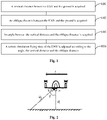
- Fig. 1 shows a step flowchart of Embodiment 1 for a method for terrain simulation flying of the UAV of the disclosure.
- the method may specifically include the steps as follows.
- Step 101 A vertical distance between a UAV and the ground is acquired.
- Step 102 An oblique distance between the UAV and the ground is acquired.
- Step 103 An angle between the vertical distance and the oblique distance is acquired.
- a distance sensor may be installed on the UAV in the embodiment of the disclosure, and the distance between the UAV and the ground can be measured according to the distance sensor. Specifically speaking, the vertical distance between the UAV and the ground and the oblique distance between the UAV and the ground can be acquired by means of the distance sensor.
- At least one vertically-downward vertical distance sensor and at least one obliquely-downward oblique distance sensor may be installed on the UAV.
- the vertical distance sensor is used for acquiring the vertical distance between the UAV and the ground
- the oblique distance sensor is used for acquiring the oblique distance between the UAV and the ground.
- a vertically-downward distance sensor (vertical distance sensor) is installed on the UAV usually, but certainly, there may be multiple vertical distance sensors.
- Multiple obliquely-downward distance sensors (oblique distance sensor) are installed on the UAV usually, but certainly, there may be one oblique distance sensor.
- the oblique distance sensor only acquires the oblique distance of the UAV in a forward direction of the UAV and has been enough to adjust a terrain simulation flying state of the UAV, so the UAV can fly by simulating the terrain in various environments, that is, it is only necessary to acquire the oblique distance sensor of the oblique distance in the forward direction of the UAV.
- the oblique distance sensors may acquire oblique distances of other directions expect the forward direction of the UAV, and are used for adjusting the terrain simulation flying state of the UAV. It is unnecessary to limit in the embodiment of the disclosure.
- the oblique distance sensors are installed in front, back, left and right directions of the vehicle head of the UAV. There may be two manners for acquiring the oblique distance.
- Implementation Manner 1 only one oblique distance sensor works. Specifically, in a terrain simulation flying process of the UAV, in a case that the UAV moves forward toward the direction of the vehicle head, it is necessary to acquire the oblique distance of an oblique distance sensor in front of the vehicle head of the UAV, and at this time, the other oblique distance sensors may not work. In a case that the forward direction of the UAV is changed, e.g., the UAV turns to move forward toward the left side of the vehicle head, it is necessary to acquire the oblique distance of an oblique distance sensor on the left side of the vehicle head of the UAV, and at this time, the other oblique distance sensors may not work.
- Implementation Manner 2 multiple oblique distance sensors work simultaneously. Specifically, in a terrain simulation flying process of the UAV, the oblique distances of the multiple oblique distance sensors are acquired. Even in a case that the forward direction of the UAV is changed, the oblique distances of the multiple oblique distance sensors are also continuously acquired.
- the oblique distance sensors may be installed in a left front direction, a right front direction, a left back direction, a right back direction and other directions of the vehicle head of the UAV, which will not be limited in the embodiment of the disclosure. So, there may be less than or more than four oblique distance sensors practically.
- the number of the oblique distance sensors may be set according to actual demands and is not limited in the embodiment of the disclosure.
- the angle between the vertical distance and the oblique distance may refer to an installation angle of the distance sensors namely an installation angle of the vertical distance sensor and the oblique distance sensor. Since the positions of the distance sensors on the UAV may be fixed, the angle between the distance sensors may be pre-stored and then extracted as needed. Certainly, the angle between the vertical distance and the oblique distance may be obtained by real-time detection, and is not limited in the embodiment of the disclosure.
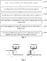
- a distance sensor a is a vertically-downward distance sensor that can be used for acquiring a vertical height H 1 between the UAV and the ground
- a distance sensor b is an oblique distance sensor in a forward direction of the UAV, which can be used for acquiring an oblique distance H 2 between the UAV and the ground.
- An angle between the distance sensor a and the distance sensor b is ⁇ .
- the distance sensor a is a UAV terrain simulation flying sensor for measuring a terrain simulation flying height of the UAV, and a flight controller of the UAV acquires a height of the UAV from the ground by reading the vertical height of the distance sensor a so as to control the UAV to maintain a pre-set height from the ground; and the distance sensor b is a UAV terrain predication judgment sensor for measuring the oblique distance between the UAV and the ground.
- Step 104 A terrain simulation flying state of the UAV is adjusted according to the angle, the vertical distance and the oblique distance.
- the terrain simulation flying state of the UAV is comprehensively adjusted according to the angle, the vertical distance and the oblique distance.
- the UAV in the embodiment of the disclosure can fly by simulating the terrain in various environments, thereby improving the operation efficiency and reliability of the UAV.
- a vertical distance between the UAV and the ground is acquired, and then a terrain simulation flying state of the UAV is adjusted according to the vertical distance, the oblique distance and an angle between the vertical distance and the oblique distance.
- the UAV in the embodiment of the disclosure can be controlled to make different flying movements according to different oblique distances between the UAV and the ground, thereby enabling the UAV to fly by simulating the terrain in various environments such as mountainous regions, hills, terraced fields, plains and high-stalk plants. Not only the operation efficiency of the UAV and the ability of the UAV to adapt to environments are improved, but also the reliability and safety of the UAV are improved.
- the embodiment of the disclosure is particularly applied to plant protection UAVs that need to keep a constant height from the ground and need to adapt to operation in various environments.
- Fig. 3 shows a step flowchart of Embodiment 2 for a method for terrain simulation flying of the UAV of the disclosure.
- the method may specifically include the steps as follows.
- Step 201 A vertical distance between a UAV and the ground is acquired.
- Step 202 An oblique distance between the UAV and the ground is acquired.
- Step 203 An angle between the vertical distance and the oblique distance is acquired.
- Step 201 to Step 203 in Method Embodiment 2 basically correspond to the specific implementation manners in Method Embodiment 1, so non-detailed descriptions for Step 201 to Step 203 in the present embodiment may refer to relevant descriptions in Embodiment 1, and will not be elaborated herein.
- terrain simulation flying of the UAV refers to that: when the ground bulges, the UAV ascends along with the ground, and when the ground sinks, the UAV descends along with the ground, namely the height between the UAV and the ground is constant.
- the flying speed of the UAV may be constant or inconstant, where the constant value may be adjusted by a user.
- the horizontal flying speed of the UAV is not required in the embodiment of the disclosure, may be set according to actual demands, and falls within the scope of coverage of the disclosure.
- the UAV Under some conditions such as field ditches and small gaps between high-stalk plants, the UAV needs to autonomously judge whether it is necessary to change along with the change of the terrain in advance. In a case that the height of the UAV is adjusted along with the change of the terrain without pre-judgment, not only the working efficiency is low and the UAV may be damaged under some terrains, but also the safety of the UAV is reduced.
- a terrain simulation flying state of the UAV is adjusted by combining the vertical distance, the oblique distance and the angle between the vertical distance and the oblique distance in the embodiment of the disclosure.
- the angle is associated with the flying height and speed generally, and in a case that the flying height and speed during agricultural operation are within a fixed range, the angle will be within a fixed range. That is because in a case that the angle is too large, an oblique sensor will become horizontal, and in a case that the angle is too small, the oblique sensor will become vertical. So, the angle is usually a fixed value, can be directly obtained as needed, and does not need to be measured.
- the magnitude of the angle is usually fixed, but may be not fixed, and may be dynamically adjusted according to a flying environment. For example, in case of flat terrain, the angle may be increased, so a pre-judgment distance can be increased. In case of rough terrain, the angle may be decreased, so the terrain condition can be more accurately pre-judged. That is the same as a principle where high beams of an automobile are turned on when a road is straight and low beams are turned on when the road condition is complicated.
- the angle in the embodiment of the present application may be fixed or not fixed. When the embodiment of the present application is implemented, the angle is set according to actual conditions. The embodiment of the present application does not need to limit the angle as a fixed angle.
- Step 204 to Step 206 a specific process that the UAV judges whether it is necessary to change along with the change of the terrain is as shown in Step 204 to Step 206.
- Step 204 One or more items of judgment data are calculated by using the angle and the vertical distance.
- one or more items of judgment data may be calculated according to the vertical distance and the angle between the vertical distance and the oblique distance firstly.
- Step 205 One or more judgment data ranges are composed by the one or more items of judgment data.
- one or more judgment data ranges are composed according to the one or more calculated items of judgment data according to a certain rule to serve as a criterion for adjusting the flying state of the UAV.
- the judgment data ranges may include:
- judgment data ranges are only exemplary.
- the judgment data may be calculated according to actual situations, and the judgment data ranges may be adjusted. No limitations are made in the embodiment of the disclosure.
- judgment conditions may be combined into fewer judgment conditions, or some judgment conditions may be subdivided into more conditions.
- the judgment conditions may be adjusted according to actual situations likewise. No limitations are made in the embodiment of the disclosure likewise.
- Step 206 The terrain simulation flying state of the UAV is adjusted according to a judgment data range within which the oblique distance falls.
- the terrain simulation flying state of the UAV is adjusted according to the judgment data range within which the oblique distance falls, so the UAV can fly in various environments, thereby improving the operation efficiency and reliability of the UAV, where adjusting the flying state of the UAV may include: adjusting the flying height of the UAV, adjusting the flying speed of the UAV, and certainly, making the UAV hover and controlling the UAV to return.
- the flying speed and flying height of the UAV are constant.
- adaptive adjustment will be made according to the terrain.
- Condition 1 In a case that the oblique distance falls within the first judgment data range, a terrain simulation flying speed of the UAV is maintained, and a terrain simulation flying height of the UAV is adjusted according to the vertical distance.
- H 2 satisfies Formula (1): 2 3 ⁇ H 1 / COS ⁇ ⁇ H 2 ⁇ 4 3 ⁇ H 1 / COS ⁇
- the UAV may directly adjust the flying height according to H 1 measured by the distance sensor a, the terrain simulation flying speed of the UAV is maintained, and other movements are not needed.
- H 2 satisfies Formula (2) or Formula (1): 1 3 ⁇ H 1 / COS ⁇ ⁇ H 2 ⁇ 2 3 ⁇ H 1 / COS ⁇
- Condition 2 may be subdivided into two conditions, as shown in Fig. 4-(a) and Fig. 4-(b) respectively.
- Sub-condition 1 in a case that H 2 measured by the distance sensor b within the first schedule time always satisfies Formula (2), as shown in Fig. 4-(a) , it is shown that there is an abrupt slope in a forward direction of the UAV. From the perspective of safety, the UAV needs to reduce the flying speed and is controlled to start ascending the abrupt slope. When the UAV climbs up the abrupt slope, and after H 2 satisfies Formula (1), the UAV continuously operates at the original flying speed. Certainly, the terrain simulation flying height is continuously adjusted according to H 1 measured by the distance sensor a.
- Sub-condition 2 in a case that H 2 measured by the distance sensor b within the first schedule time only satisfies Formula (2) within a short time (second schedule time) and also satisfies Formula (1) within the first schedule time, as shown in Fig. 4-(b) , it is shown that there is a narrow bulge from the ground and the height of the bulge is smaller than 2 3 H 2 . In this case, when the UAV flies over the bulge, the UAV does not need to ascend, but continuously flies according to the original height and speed by directly ignoring the bulge.
- H 2 satisfies Formula (3) and Formula (2): 2 3 ⁇ H 1 / COS ⁇ ⁇ H 2
- H 2 satisfies Formula (3)
- H 2 measured by the distance sensor b satisfies Formula (2)
- the UAV may continuously move forward, the speed may be recovered to the original terrain simulation flying speed of the UAV at this time, and the terrain simulation flying height of the UAV is continuously controlled according to H 2 measured by the distance sensor b.
- H 2 satisfies Formula (4) or Formula (1): 4 3 ⁇ H 1 / COS ⁇ ⁇ H 2 ⁇ 2 * H 1 / COS ⁇
- Condition 4 may be subdivided into two conditions, as shown in Fig. 6-(a) and Fig. 6-(b) respectively.
- Sub-condition 1 in a case that H 2 measured by the distance sensor b within the third schedule time always satisfies Formula (1), as shown in Fig. 6-(a) , it is shown that there is a large pit in the forward direction of the UAV. The UAV needs to reduce the flying speed.
- Sub-condition 2 in a case that the value measured by the distance sensor b satisfies Formula (4) within a short time (fourth schedule time) and then satisfies Formula (1), as shown in Fig. 6-(b) , it is shown that there is a narrow pit in the ground such as a field drainage ditch or a sparse region in high-stalk plants, the UAV does not need to descend, and continuously flies according to the original speed by directly ignoring the pit, and the terrain simulation flying height of the UAV is controlled according to H 2 measured by the distance sensor b.
- first schedule time and the third schedule time may be set to be identical or different.
- first schedule time and the third schedule time may be set as 10m or 20m.
- the second schedule time and the fourth schedule time may be set to be identical or different.
- the second schedule time and the fourth schedule time may be set as 1m or 2m. These times are set according to actual conditions, and are not limited in the embodiment of the disclosure.
- Condition 5 In a case that the oblique distance falls within the fifth judgment data range, the UAV hovers, or the UAV is controlled to return.
- H 2 satisfies Formula (5): 2 * H 1 / COS ⁇ ⁇ H 2
- a vertically-downward distance sensor a controls a terrain simulation flying height of a UAV, and one or more distance sensors b installed in a forward direction of the UAV predict the height conditions of the forward direction of the UAV.
- the UAV makes different movements for different heights of the forward direction, thereby enabling the UAV to fly by simulating the terrain in various complicated environments such as mountainous regions, hills, terraced fields and plains.
- the operation efficiency of the UAV is improved, and the safety and reliability of the UAV are improved.
- the method embodiment is expressed as a series of movement combinations.
- those skilled in the art should learn of that the embodiment of the disclosure is not limited by a described movement sequence. That is because some steps may be executed in other sequences or at the same time according to the embodiment of the disclosure.
- those skilled in the art should also learn of that the embodiment described in the specification falls within preferable embodiments, and involved movements may not be necessary for the embodiment of the disclosure.
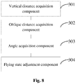
- Fig. 8 shows a block diagram of an embodiment for a Device for terrain simulation flying of the UAV of the disclosure.
- the device may specifically include the following components:
- the flying state adjustment component 304 may include the following sub-components:
- the judgment data ranges include a first judgment data range
- the flying state adjustment sub-component may include the following sub-component: a first flying state adjustment unit, configured to maintain, in a case that the oblique distance falls within the first judgment data range, a terrain simulation flying speed of the UAV, and control a terrain simulation flying height of the UAV according to the vertical distance.
- the judgment data ranges include a second judgment data range
- the flying state adjustment sub-component may include the following sub-components:
- the judgment data ranges include a third judgment data range
- the flying state adjustment sub-component may include the following sub-components:
- the judgment data ranges include a fourth judgment data range
- the flying state adjustment sub-component may include the following sub-components:
- the judgment data ranges include a fifth judgment data range
- the flying state adjustment sub-component may include the following sub-component: an eighth flying state adjustment unit, configured to make, in a case that the oblique distance falls within the fifth judgment data range, the UAV hover, or control the UAV to return.
- the UAV of the disclosure may specifically include: at least one vertically-downward vertical distance sensor, configured to measure a vertical distance between the UAV and the ground; at least one obliquely-downward oblique distance sensor, configured to measure an oblique distance between the UAV and the ground; and the above-mentioned Device for terrain simulation flying of the UAV.
- a vertical distance acquisition component 301 in the Device for terrain simulation flying of the UAV acquires a vertical distance between the UAV and the ground from the vertical distance sensor
- an oblique distance acquisition component 302 in the Device for terrain simulation flying of the UAV acquires an oblique distance between the UAV and the ground from the oblique distance sensor.
- the embodiment of the present application also provides a storage medium.
- the above-mentioned storage medium may be used for storing program codes for executing the UAV terrain simulation flying method provided in the above-mentioned embodiment.
- the above-mentioned storage medium may be located in any one computer terminal in a computer terminal group in a computer network or located in a mobile terminal group.
- the storage medium is configured to store program codes for executing the following steps: acquiring a vertical distance between a UAV and the ground; acquiring an oblique distance between the UAV and the ground; acquiring an angle between the vertical distance and the oblique distance; and adjusting a terrain simulation flying state of the UAV according to the angle, the vertical distance and the oblique distance.
- the embodiment of the present application also provides a processor.
- the above-mentioned processor may run the following program codes for executing the UAV terrain simulation flying method provided in the above-mentioned embodiment: acquiring a vertical distance between a UAV and the ground; acquiring an oblique distance between the UAV and the ground; acquiring an angle between the vertical distance and the oblique distance; and adjusting a terrain simulation flying state of the UAV according to the angle, the vertical distance and the oblique distance.
- the embodiment of the disclosure may be provided as a method, a device or a computer program product.
- forms of complete hardware embodiments, complete software embodiments or embodiments integrating software and hardware may be adopted in the embodiment of the disclosure.
- a form of computer program product implemented on one or more computer available storage media including, but not limited to, a disk memory, a CD Read-Only Memory (CD-ROM), an optical memory and the like
- computer available program codes may be adopted in the embodiment of the disclosure.
- each flow and/or block in the flowcharts and/or the block diagrams and combination of the flows and/or the blocks in the flowcharts and/or the block diagrams may be implemented by computer program instructions.
- These computer program instructions may be provided for a general computer, a dedicated computer, an embedded processor or processors of other programmable data processing terminal equipment to generate a machine, such that a device for implementing functions designated in one or more flows of the flowcharts and/or one or more blocks of the block diagrams is generated via instructions executed by the computers or the processors of the other programmable data processing terminal equipment.
- These computer program instructions may also be stored in a computer readable memory capable of guiding the computers or the other programmable data processing terminal equipment to work in a specific manner, so that a manufactured product including an instruction device is generated via the instructions stored in the computer readable memory, and the instruction device achieves the functions designated in one or more flows of the flowcharts and/or one or more blocks of the block diagrams.
- These computer program instructions may also be loaded to the computers or the other programmable data processing terminal equipment, so that processing implemented by the computers is generated by executing a series of operation steps on the computers or the other programmable terminal equipment, and therefore the instructions executed on the computers or the other programmable terminal equipment provide a step of achieving the functions designated in one or more flows of the flowcharts and/or one or more blocks of the block diagrams.
- relation terms such as 'first' and 'second' are only used for distinguishing an entity or operation from another entity or operation herein, it is not required or implied that these entities or operations have any practical relation or sequence.
- terms 'include', 'have' or any other inflexions thereof are intended to cover non-exclusive inclusions, such that a process, a method, an article or terminal equipment including a series of elements not only includes those elements, but also includes other elements that are not clearly listed, or further includes elements inherent to the process, the method, the article or the terminal equipment. Under the condition of no more limitations, it is not excluded that additional identical elements exist in the process, the method, the article or the terminal equipment including elements defined by a sentence 'including a ...'.
Landscapes
- Engineering & Computer Science (AREA)
- Aviation & Aerospace Engineering (AREA)
- Physics & Mathematics (AREA)
- General Physics & Mathematics (AREA)
- Automation & Control Theory (AREA)
- Remote Sensing (AREA)
- Radar, Positioning & Navigation (AREA)
- Theoretical Computer Science (AREA)
- Business, Economics & Management (AREA)
- Educational Administration (AREA)
- Educational Technology (AREA)
- Control Of Position, Course, Altitude, Or Attitude Of Moving Bodies (AREA)
- Traffic Control Systems (AREA)
Claims (11)
- Procédé de vol de simulation de terrain d'un véhicule aérien sans pilote, UAV, comprenant :l'acquisition d'une distance verticale entre un UAV et le sol (101) ;l'acquisition d'une distance oblique entre l'UAV et le sol (102) ;l'acquisition d'un angle entre la distance verticale et la distance oblique (103) ; etl'ajustement d'un état de vol de simulation de terrain de l'UAV selon l'angle, la distance verticale et la distance oblique (104),dans lequel l'étape d'ajustement de l'état de vol de simulation de terrain de l'UAV selon l'angle, la distance verticale et la distance oblique comprend :le calcul d'un ou plusieurs éléments de données de jugement en utilisant l'angle et la distance verticale ;la composition d'une ou plusieurs plages de données de jugement par le ou les éléments de données de jugement ; etl'ajustement de l'état de vol de simulation de terrain de l'UAV selon une plage de données de jugement dans laquelle tombe la distance oblique ;caractérisé en ce queles plages de données de jugement comprennent une première plage de données de jugement et l'étape d'ajustement de l'état de vol de simulation de terrain de l'UAV, selon une plage de données de jugement dans laquelle tombe la distance oblique, comprend :
dans un cas où la distance oblique tombe dans la première plage de données de jugement, le maintien d'une vitesse de vol de simulation de terrain de l'UAV et l'ajustement d'une hauteur de vol de simulation de terrain de l'UAV selon la distance verticale. - Procédé selon la revendication 1, dans lequel les plages de données de jugement comprennent une deuxième plage de données de jugement et l'étape d'ajustement de l'état de vol de simulation de terrain de l'UAV selon la plage de données de jugement dans laquelle tombe la distance oblique comprend :dans un cas où la distance oblique tombe toujours dans la deuxième plage de données de jugement dans un premier horaire programmé, la diminution de la vitesse de vol de simulation de terrain de l'UAV et l'augmentation de la hauteur de vol de simulation de terrain de l'UAV ; etdans un cas où la distance oblique est commutée pour tomber dans la première plage de données de jugement à partir de la première plage de données de jugement après que la distance oblique tombe dans la deuxième plage de données de jugement dans un second horaire programmé, le maintien de la vitesse de vol de simulation de terrain de l'UAV et l'ajustement de la hauteur de vol de simulation de terrain de l'UAV selon la distance verticale, le deuxième horaire programmé étant inférieur au premier horaire programmé.
- Procédé selon la revendication 2, dans lequel les plages de données de jugement comprennent une troisième plage de données de jugement et l'étape d'ajustement de l'état de vol de simulation de terrain de l'UAV selon la plage de données de jugement dans laquelle tombe la distance oblique comprend :dans un cas où la distance oblique tombe dans la troisième plage de données de jugement, le fait d'amener l'UAV à réaliser un vol stationnaire et l'augmentation de la hauteur de vol de simulation de terrain de l'UAV ; etdans un cas où la présence de la distance oblique dans la troisième plage de données de jugement est commutée pour tomber dans la deuxième plage de données de jugement, la récupération de la vitesse de vol de simulation de terrain de l'UAV et la commande de la hauteur de vol de simulation de terrain de l'UAV selon la verticale distance.
- Procédé selon la revendication 1, dans lequel les plages de données de jugement comprennent une quatrième plage de données de jugement et l'étape d'ajustement de l'état de vol de simulation de terrain de l'UAV selon la plage de données de jugement dans laquelle tombe la distance oblique comprend :dans un cas où la distance oblique tombe toujours dans la quatrième plage de données de jugement dans un troisième horaire programmé, la diminution de la vitesse de vol de simulation de terrain de l'UAV et la réduction de la hauteur de vol de simulation de terrain de I'UAV ; etdans un cas où la présence dans la quatrième plage de données de jugement est commutée pour tomber dans la première plage de données de jugement après que la distance oblique tombe dans la quatrième plage de données de jugement dans un quatrième horaire programmé, le maintien de la vitesse de vol de simulation de terrain de l'UAV et l'ajustement de la hauteur de vol de simulation de terrain de l'UAV selon la distance verticale, le quatrième horaire programmé est inférieur au troisième horaire programmé.
- Procédé selon la revendication 1, dans lequel les plages de données de jugement comprennent une cinquième plage de données de jugement et l'étape d'ajustement de l'état de vol de simulation de terrain de l'UAV selon la plage de données de jugement dans laquelle tombe la distance oblique comprend :dans un cas où la distance oblique tombe dans la cinquième plage de données de jugement, le fait d'amener l'UAV à réaliser un vol stationnaire ou la commande du retour de l'UAV.
- Dispositif de vol de simulation de terrain d'un véhicule aérien sans pilote, UAV, comprenant :un composant d'acquisition de distance verticale (301), configuré pour acquérir une distance verticale entre un UAV et le sol ;un composant d'acquisition de distance oblique (302), configuré pour acquérir une distance oblique entre l'UAV et le sol ;un composant d'acquisition d'angle (303), configuré pour acquérir un angle entre la distance verticale et la distance oblique ; etun composant d'ajustement d'état de vol (304), configuré pour ajuster un état de vol de simulation de terrain de l'UAV selon l'angle, la distance verticale et la distance oblique.dans lequel le composant d'ajustement d'état de vol (304) comprend :un sous-composant de calcul de données de jugement, configuré pour calculer un ou plusieurs éléments de données de jugement en utilisant l'angle et la distance verticale ;un sous-composant de composition de plage de données de jugement, configuré pour composer une ou plusieurs plages de données de jugement par le ou les éléments de données de jugement ; etun sous-composant d'ajustement d'état de vol, configuré pour ajuster l'état de vol de simulation de terrain de l'UAV selon une plage de données de jugement dans laquelle tombe la distance oblique ;caractérisé en ce queles plages de données de jugement comprennent une première plage de données de jugement et le sous-composant d'ajustement d'état de vol comprend : une première unité d'ajustement d'état de vol, configurée pour maintenir, dans un cas où la distance oblique tombe dans la première plage de données de jugement, une vitesse de vol de simulation de terrain de l'UAV et commander une hauteur de vol de simulation de terrain de l'UAV en fonction de la distance verticale.
- Dispositif selon la revendication 6, dans lequel les plages de données de jugement comprennent une deuxième plage de données de jugement et le sous-composant d'ajustement d'état de vol comprend :une deuxième unité d'ajustement d'état de vol, configurée pour diminuer, dans un cas où la distance oblique tombe toujours dans la deuxième plage de données de jugement dans un premier horaire programmé, la vitesse de vol de simulation de terrain de l'UAV et augmenter la hauteur de vol de simulation de terrain de l'UAV ; etune troisième unité d'ajustement d'état de vol, configurée pour maintenir, dans un cas où la présence dans la deuxième plage de données de jugement est commutée pour tomber dans la première plage de données de jugement après que la distance oblique tombe dans la deuxième plage de données de jugement dans un deuxième horaire programmé, la vitesse de vol de simulation de terrain de l'UAV et maintenir la hauteur de vol de simulation de terrain de l'UAV, le deuxième horaire programmé est plus petit que le premier horaire programmé.
- Dispositif selon la revendication 7, dans lequel les plages de données de jugement comprennent une troisième plage de données de jugement et le sous-composant d'ajustement d'état de vol comprend :une quatrième unité d'ajustement d'état de vol, configurée pour amener, dans un cas où la distance oblique tombe dans la troisième plage de données de jugement, l'UAV à réaliser un vol stationnaire et augmenter la hauteur de vol de simulation de terrain de l'UAV ; etune cinquième unité d'ajustement d'état de vol, configurée pour récupérer, dans un cas où la présence de la distance oblique dans la troisième plage de données de jugement est commutée pour tomber dans la deuxième plage de données de jugement, la vitesse de vol de simulation de terrain de l'UAV et commander la hauteur de vol de simulation de terrain de l'UAV selon la distance verticale.
- Dispositif selon la revendication 7, dans lequel les plages de données de jugement comprennent une quatrième plage de données de jugement et le sous-composant d'ajustement d'état de vol comprend :une sixième unité d'ajustement d'état de vol, configurée pour réduire, dans un cas où la distance oblique tombe toujours dans la quatrième plage de données de jugement dans un troisième horaire programmé, la vitesse de vol de simulation de terrain de l'UAV et réduire la hauteur de vol de simulation de terrain de l'UAV ; etune septième unité d'ajustement d'état de vol, configurée pour maintenir, dans un cas où la présence dans la quatrième plage de données de jugement est commutée pour tomber dans la première plage de données de jugement après que la distance oblique tombe dans la quatrième plage de données de jugement dans un quatrième horaire programmé, la vitesse de vol de simulation de terrain de l'UAV et ajuster la hauteur de vol de simulation de terrain de l'UAV selon la distance verticale, le quatrième horaire programmé est inférieur au troisième horaire programmé.
- Dispositif selon la revendication 6, dans lequel les plages de données de jugement comprennent une cinquième plage de données de jugement et le sous-composant d'ajustement d'état de vol comprend :une huitième unité d'ajustement d'état de vol, configurée pour amener, dans un cas où la distance oblique tombe dans la cinquième plage de données de jugement, l'UAV à réaliser un vol stationnaire ou commander le retour de l'UAV.
- Véhicule aérien sans pilote, UAV, comprenant :au moins un capteur de distance verticale, verticalement vers le bas, configuré pour mesurer une distance verticale entre l'UAV et le sol ;au moins un capteur de distance oblique, obliquement vers le bas, configuré pour mesurer une distance oblique entre l'UAV et le sol ; etle dispositif de vol de simulation de terrain de l'UAV selon l'une quelconque des revendications 6 à 10.
Priority Applications (1)
| Application Number | Priority Date | Filing Date | Title |
|---|---|---|---|
| PL17836359T PL3326041T3 (pl) | 2016-08-03 | 2017-07-31 | Sposób i urządzenie do lotu bezzałogowego statku powietrznego z symulacją terenu oraz bezzałogowy statek powietrzny |
Applications Claiming Priority (2)
| Application Number | Priority Date | Filing Date | Title |
|---|---|---|---|
| CN201610633363.8A CN106292699B (zh) | 2016-08-03 | 2016-08-03 | 无人机仿地飞行的方法、装置和无人机 |
| PCT/CN2017/095311 WO2018024177A1 (fr) | 2016-08-03 | 2017-07-31 | Procédé et dispositif de vol de simulation de terrain de véhicule aérien sans pilote et véhicule aérien sans pilote |
Publications (3)
| Publication Number | Publication Date |
|---|---|
| EP3326041A1 EP3326041A1 (fr) | 2018-05-30 |
| EP3326041A4 EP3326041A4 (fr) | 2019-04-03 |
| EP3326041B1 true EP3326041B1 (fr) | 2022-04-13 |
Family
ID=57664790
Family Applications (1)
| Application Number | Title | Priority Date | Filing Date |
|---|---|---|---|
| EP17836359.4A Active EP3326041B1 (fr) | 2016-08-03 | 2017-07-31 | Procédé et dispositif de vol de simulation de terrain de véhicule aérien sans pilote et véhicule aérien sans pilote |
Country Status (10)
| Country | Link |
|---|---|
| US (1) | US10712751B2 (fr) |
| EP (1) | EP3326041B1 (fr) |
| JP (1) | JP6634512B2 (fr) |
| KR (1) | KR20180023959A (fr) |
| CN (1) | CN106292699B (fr) |
| AU (1) | AU2017305353B2 (fr) |
| ES (1) | ES2917002T3 (fr) |
| HU (1) | HUE059027T2 (fr) |
| PL (1) | PL3326041T3 (fr) |
| WO (1) | WO2018024177A1 (fr) |
Families Citing this family (34)
| Publication number | Priority date | Publication date | Assignee | Title |
|---|---|---|---|---|
| CN106292699B (zh) * | 2016-08-03 | 2017-12-12 | 广州极飞科技有限公司 | 无人机仿地飞行的方法、装置和无人机 |
| CN106774376A (zh) * | 2017-01-25 | 2017-05-31 | 上海拓攻机器人有限公司 | 一种无人机仿地飞行控制方法及系统 |
| US10353401B2 (en) * | 2017-05-01 | 2019-07-16 | EAVision Corporation | Detecting and following terrain height autonomously along a flight path |
| CN107515620B (zh) * | 2017-10-20 | 2021-12-24 | 广州极飞科技股份有限公司 | 一种无人机仿地飞行控制方法及装置 |
| EP3637214A4 (fr) * | 2017-12-18 | 2020-12-23 | SZ DJI Technology Co., Ltd. | Procédé de commande de véhicule aérien sans pilote et véhicule aérien sans pilote |
| CN108681328A (zh) * | 2018-05-10 | 2018-10-19 | 杭州瓦屋科技有限公司 | 植保无人机仿地飞行方法及装置 |
| CN108664034A (zh) * | 2018-05-10 | 2018-10-16 | 杭州瓦屋科技有限公司 | 植保无人机在茶园的仿地飞行方法及装置 |
| CN108681335A (zh) * | 2018-05-10 | 2018-10-19 | 杭州瓦屋科技有限公司 | 植保无人机在坡地的仿地飞行方法及装置 |
| CN109032157A (zh) * | 2018-07-23 | 2018-12-18 | 拓攻(南京)机器人有限公司 | 无人机仿地作业方法、装置、设备及存储介质 |
| CN109283936A (zh) * | 2018-08-15 | 2019-01-29 | 广州极飞科技有限公司 | 移动装置控制方法、装置及终端 |
| WO2020047746A1 (fr) * | 2018-09-04 | 2020-03-12 | 深圳市大疆创新科技有限公司 | Procédé et système de commande de robot mobile, et robot mobile |
| CN109298722A (zh) * | 2018-11-05 | 2019-02-01 | 苏州极目机器人科技有限公司 | 地形跟随飞行方法、地形跟随飞行控制方法和作业方法 |
| CN109828274B (zh) * | 2019-01-07 | 2022-03-04 | 深圳市道通智能航空技术股份有限公司 | 调整机载雷达的主探测方向的方法、装置和无人机 |
| CN110001990B (zh) * | 2019-02-21 | 2020-11-10 | 北京航空航天大学 | 基于空间位置的菲涅尔透镜光学助降系统可视化仿真方法 |
| CN113287077B (zh) * | 2019-07-08 | 2024-06-25 | 松下知识产权经营株式会社 | 信息处理装置、信息处理方法以及无人飞行器 |
| WO2021020569A1 (fr) * | 2019-07-31 | 2021-02-04 | ヤマハ発動機株式会社 | Procédé de réalisation de mensuration forestière, système de mensuration forestière, procédé de détermination de trajectoire de vol d'engin volant sans pilote embarqué, procédé de capture d'image, procédé de dispersion et programme informatique |
| CN110703801A (zh) * | 2019-10-30 | 2020-01-17 | 上海歌尔泰克机器人有限公司 | 一种无人机模拟方法、装置及设备和存储介质 |
| CN112773261B (zh) * | 2019-11-04 | 2022-06-21 | 美智纵横科技有限责任公司 | 规避障碍物的方法、装置及扫地机器人 |
| CN112937911A (zh) * | 2019-12-10 | 2021-06-11 | 广州极飞科技股份有限公司 | 无人机的故障检测方法及装置、存储介质和处理器 |
| WO2021237469A1 (fr) * | 2020-05-26 | 2021-12-02 | 深圳市大疆创新科技有限公司 | Procédé de commande de vol d'un véhicule aérien sans pilote, véhicule aérien sans pilote, dispositif électronique et support |
| CN111638514B (zh) * | 2020-06-19 | 2023-08-04 | 四川陆垚控制技术有限公司 | 无人机测高方法及无人机导航滤波器 |
| WO2022094785A1 (fr) * | 2020-11-04 | 2022-05-12 | 深圳市大疆创新科技有限公司 | Procédé de commande de vol, véhicule aérien sans pilote, dispositif électronique et support |
| TWI785442B (zh) * | 2020-12-25 | 2022-12-01 | 為升電裝工業股份有限公司 | 無人機及其飛行控制方法 |
| CN112506229B (zh) * | 2021-02-05 | 2021-04-30 | 四川睿谷联创网络科技有限公司 | 一种旅游观光飞行器的飞行预设路径生成方法 |
| KR102624504B1 (ko) | 2021-10-12 | 2024-01-11 | 한국항공대학교산학협력단 | 무인 비행 장치의 안전 운항을 위한 장애물 주변의 지형적 경계 생성 시스템 및 방법 |
| CN113917458B (zh) * | 2021-10-21 | 2025-08-19 | 应急管理部四川消防研究所 | 一种火灾中建筑结构位移的自动监测方法 |
| CN113963278B (zh) * | 2021-10-27 | 2024-07-30 | 厦门精图信息技术有限公司 | 基于遥感技术的智慧林业综合管理系统、方法及设备 |
| CN117693722A (zh) * | 2021-11-15 | 2024-03-12 | 深圳市大疆创新科技有限公司 | 无人机的控制方法、控制装置、无人机及存储介质 |
| WO2023082282A1 (fr) * | 2021-11-15 | 2023-05-19 | 深圳市大疆创新科技有限公司 | Procédé de commande, dispositif de commande et engin volant sans pilote embarqué |
| CN114038267B (zh) * | 2021-11-30 | 2023-06-06 | 重庆电子工程职业学院 | 一种无人机航空摄影测量教学系统 |
| CN114368335B (zh) * | 2022-02-24 | 2023-04-18 | 浙江华云清洁能源有限公司 | 一种无人机纠偏装置和具有该无人机纠偏装置的移动车 |
| CN116902220B (zh) * | 2023-09-11 | 2023-12-22 | 农业农村部南京农业机械化研究所 | 一种农用无人飞机仿地飞行检测方法和检测设备 |
| CN117429645B (zh) * | 2023-12-21 | 2024-03-19 | 南京拓恒航空科技有限公司 | 一种应用无人机的高空地形勘测测量装置及方法 |
| CN121008592B (zh) * | 2025-10-27 | 2026-02-24 | 北京煜邦电力技术股份有限公司 | 基于ai视觉的配网无人机仿地飞行方法、设备及介质 |
Citations (1)
| Publication number | Priority date | Publication date | Assignee | Title |
|---|---|---|---|---|
| US3530465A (en) * | 1957-07-10 | 1970-09-22 | Sperry Rand Corp | Obstacle clearance system for aircraft |
Family Cites Families (32)
| Publication number | Priority date | Publication date | Assignee | Title |
|---|---|---|---|---|
| FR87853A (fr) * | 1962-05-18 | |||
| FR2585483B1 (fr) * | 1985-07-26 | 1987-10-09 | Thomson Csf | Procede et dispositif d'aide a la tenue de hauteur dans la navigation aerienne |
| US4698635A (en) * | 1986-03-02 | 1987-10-06 | The United States Of America As Represented By The Secretary Of The Navy | Radar guidance system |
| US4760396A (en) * | 1986-07-11 | 1988-07-26 | Merit Technology Incorporated | Apparatus and method for adjusting set clearance altitude in a terrain following radar system |
| US5028998A (en) * | 1989-02-06 | 1991-07-02 | Honeywell Regelsysteme Gmbh | Electronic zoom for wide-angle line scanners |
| JP2000180100A (ja) * | 1998-12-17 | 2000-06-30 | Nec Corp | 夜間用無人偵察装置 |
| US6222464B1 (en) * | 1999-12-02 | 2001-04-24 | Sikorsky Aircraft Corporation | Self compensating target acquisition system for minimizing areas of threat |
| FR2844607B1 (fr) * | 2002-09-16 | 2004-12-10 | Centre Nat Rech Scient | Systeme d'assistance au pilotage de l'altitude et de la vitesse horizontale, perpendiculaire a l'aplomb, d'un aeronefs equipes de ce systeme |
| US7424133B2 (en) * | 2002-11-08 | 2008-09-09 | Pictometry International Corporation | Method and apparatus for capturing, geolocating and measuring oblique images |
| FR2886439B1 (fr) * | 2005-05-24 | 2010-11-05 | Eurocopter France | Procede et dispositif d'aide au pilotage d'un aeronef a basse altitude |
| US8666661B2 (en) * | 2006-03-31 | 2014-03-04 | The Boeing Company | Video navigation |
| US7693617B2 (en) * | 2006-09-19 | 2010-04-06 | The Boeing Company | Aircraft precision approach control |
| FR2913781B1 (fr) * | 2007-03-13 | 2009-04-24 | Thales Sa | Procede de reduction des nuisances d'alerte anticollision avec des obstacles pour aeronef |
| JP5010332B2 (ja) * | 2007-04-24 | 2012-08-29 | 三菱重工業株式会社 | 水中航走体運動制御装置および水中航走体 |
| US7970532B2 (en) | 2007-05-24 | 2011-06-28 | Honeywell International Inc. | Flight path planning to reduce detection of an unmanned aerial vehicle |
| FR2923623B1 (fr) * | 2007-11-13 | 2015-02-27 | Thales Sa | Systeme de securisation d'un plan de vol pour aeronef |
| FR2932306B1 (fr) * | 2008-06-10 | 2010-08-20 | Thales Sa | Procede et dispositif d'aide a la navigation pour un aeronef vis-a-vis des obstacles. |
| FR2969307B1 (fr) * | 2010-12-21 | 2013-01-18 | Thales Sa | Procede et dispositif de suivi de variation de terrain |
| JP5618840B2 (ja) * | 2011-01-04 | 2014-11-05 | 株式会社トプコン | 飛行体の飛行制御システム |
| FR2977333B1 (fr) * | 2011-06-28 | 2014-01-31 | Parrot | Procede de controle dynamique d'attitude d'un drone, pour l'execution automatique d'une figure de type vrille ou salto |
| JP5759392B2 (ja) * | 2012-01-11 | 2015-08-05 | 三井造船株式会社 | 水中航走体 |
| FR2988618B1 (fr) * | 2012-03-30 | 2014-05-09 | Parrot | Estimateur d'altitude pour drone a voilure tournante a rotors multiples |
| KR101400397B1 (ko) * | 2012-11-13 | 2014-05-27 | 재단법인대구경북과학기술원 | 태양광 패널 관리용 무인 비행 로봇 |
| CN104977935A (zh) * | 2014-04-04 | 2015-10-14 | 北京中科火冠科技有限公司 | 一种旋翼无人机风场静电喷药装置及方法 |
| US9635259B2 (en) * | 2015-01-21 | 2017-04-25 | Izak Jan van Cruyningen | Forward motion compensated flight path |
| CN204631626U (zh) * | 2015-06-02 | 2015-09-09 | 成都理工大学 | 一种用于无人机飞行的地形跟踪装置 |
| CN204883371U (zh) * | 2015-07-06 | 2015-12-16 | 杨珊珊 | 一种定维飞行的多旋翼飞行器及其控制器 |
| CN205060033U (zh) * | 2015-09-24 | 2016-03-02 | 郑州领航模型有限公司 | 飞行高度精确的农药喷洒机 |
| CN108319288A (zh) * | 2016-01-26 | 2018-07-24 | 深圳市大疆创新科技有限公司 | 无人机及其飞行控制方法与系统 |
| CN113342038B (zh) * | 2016-02-29 | 2024-08-20 | 星克跃尔株式会社 | 为无人飞行器的飞行生成地图的方法和系统 |
| CN106292699B (zh) * | 2016-08-03 | 2017-12-12 | 广州极飞科技有限公司 | 无人机仿地飞行的方法、装置和无人机 |
| US10353401B2 (en) * | 2017-05-01 | 2019-07-16 | EAVision Corporation | Detecting and following terrain height autonomously along a flight path |
-
2016
- 2016-08-03 CN CN201610633363.8A patent/CN106292699B/zh active Active
-
2017
- 2017-07-31 KR KR1020187001840A patent/KR20180023959A/ko not_active Ceased
- 2017-07-31 WO PCT/CN2017/095311 patent/WO2018024177A1/fr not_active Ceased
- 2017-07-31 AU AU2017305353A patent/AU2017305353B2/en not_active Ceased
- 2017-07-31 EP EP17836359.4A patent/EP3326041B1/fr active Active
- 2017-07-31 ES ES17836359T patent/ES2917002T3/es active Active
- 2017-07-31 US US15/753,841 patent/US10712751B2/en not_active Expired - Fee Related
- 2017-07-31 PL PL17836359T patent/PL3326041T3/pl unknown
- 2017-07-31 JP JP2018508193A patent/JP6634512B2/ja not_active Expired - Fee Related
- 2017-07-31 HU HUE17836359A patent/HUE059027T2/hu unknown
Patent Citations (1)
| Publication number | Priority date | Publication date | Assignee | Title |
|---|---|---|---|---|
| US3530465A (en) * | 1957-07-10 | 1970-09-22 | Sperry Rand Corp | Obstacle clearance system for aircraft |
Also Published As
| Publication number | Publication date |
|---|---|
| PL3326041T3 (pl) | 2022-06-27 |
| US20190146524A1 (en) | 2019-05-16 |
| HUE059027T2 (hu) | 2022-09-28 |
| KR20180023959A (ko) | 2018-03-07 |
| AU2017305353B2 (en) | 2019-02-21 |
| EP3326041A1 (fr) | 2018-05-30 |
| WO2018024177A1 (fr) | 2018-02-08 |
| ES2917002T3 (es) | 2022-07-06 |
| JP2018527669A (ja) | 2018-09-20 |
| CN106292699A (zh) | 2017-01-04 |
| EP3326041A4 (fr) | 2019-04-03 |
| AU2017305353A1 (en) | 2018-03-01 |
| CN106292699B (zh) | 2017-12-12 |
| JP6634512B2 (ja) | 2020-01-22 |
| US10712751B2 (en) | 2020-07-14 |
Similar Documents
| Publication | Publication Date | Title |
|---|---|---|
| EP3326041B1 (fr) | Procédé et dispositif de vol de simulation de terrain de véhicule aérien sans pilote et véhicule aérien sans pilote | |
| US11169541B2 (en) | Detecting and following terrain height autonomously along a flight path | |
| US20220234733A1 (en) | Aerial Vehicle Smart Landing | |
| CN110007686B (zh) | 用于无人飞行器的防撞系统和方法 | |
| EP3128386B1 (fr) | Procédé et dispositif de poursuite d'une cible mobile avec un véhicule aérien | |
| US7765062B2 (en) | Method and system for autonomous tracking of a mobile target by an unmanned aerial vehicle | |
| US10126750B2 (en) | Kinematic motion planning with regional planning constraints | |
| US11922819B2 (en) | System and method for autonomously landing a vertical take-off and landing (VTOL) aircraft | |
| US20240425197A1 (en) | Autonomous landing systems and methods for vertical landing aircraft | |
| CN107544548B (zh) | 控制无人机作业的方法、装置及无人机 | |
| JP2015006874A (ja) | 3次元証拠グリッドを使用する自律着陸のためのシステムおよび方法 | |
| CN109903592B (zh) | 一种基于误差理论的高精度航空器自动近地防撞系统地形扫描方法 | |
| KR20200003897A (ko) | 지형 예측 방법, 장치, 시스템 및 무인기 | |
| CN110221625A (zh) | 无人机精确位置的自主降落导引方法 | |
| JP2021504790A (ja) | 無人機又は農業用無人機の制御方法、及び無人機の制御装置 | |
| CN120215558A (zh) | 一种无人机定点降落控制方法、设备及介质 | |
| EP4300136B1 (fr) | Procédé d'évitement automatique d'obstacle, dispositif électronique et véhicule aérien sans pilote | |
| US20210199798A1 (en) | Continuous wave radar terrain prediction method, device, system, and unmanned aerial vehicle | |
| KR20170101087A (ko) | 복합센서를 이용한 드론 제어 장치 및 그 방법 | |
| US12179936B2 (en) | Landing zone landing assistance system for a rotary wing aircraft | |
| CN114008554A (zh) | 无人机的飞行控制方法、无人机、电子设备及介质 | |
| EP3060952B1 (fr) | Commande de capteur de position et de direction pour la recherche | |
| Portugal | Optimal Multi-Sensor Collision Avoidance System for Small Fixed-Wing UAV | |
| CN112437906A (zh) | 可移动平台的控制方法、可移动平台和存储介质 | |
| CN118747001A (zh) | 一种无人机低空自动避障方法 |
Legal Events
| Date | Code | Title | Description |
|---|---|---|---|
| STAA | Information on the status of an ep patent application or granted ep patent |
Free format text: STATUS: THE INTERNATIONAL PUBLICATION HAS BEEN MADE |
|
| PUAI | Public reference made under article 153(3) epc to a published international application that has entered the european phase |
Free format text: ORIGINAL CODE: 0009012 |
|
| STAA | Information on the status of an ep patent application or granted ep patent |
Free format text: STATUS: REQUEST FOR EXAMINATION WAS MADE |
|
| 17P | Request for examination filed |
Effective date: 20180223 |
|
| AK | Designated contracting states |
Kind code of ref document: A1 Designated state(s): AL AT BE BG CH CY CZ DE DK EE ES FI FR GB GR HR HU IE IS IT LI LT LU LV MC MK MT NL NO PL PT RO RS SE SI SK SM TR |
|
| AX | Request for extension of the european patent |
Extension state: BA ME |
|
| RIN1 | Information on inventor provided before grant (corrected) |
Inventor name: CHEN, YOUSHENG |
|
| A4 | Supplementary search report drawn up and despatched |
Effective date: 20190306 |
|
| RIC1 | Information provided on ipc code assigned before grant |
Ipc: G05D 1/10 20060101AFI20190228BHEP Ipc: G05D 1/06 20060101ALI20190228BHEP |
|
| DAV | Request for validation of the european patent (deleted) | ||
| DAX | Request for extension of the european patent (deleted) | ||
| STAA | Information on the status of an ep patent application or granted ep patent |
Free format text: STATUS: EXAMINATION IS IN PROGRESS |
|
| 17Q | First examination report despatched |
Effective date: 20201209 |
|
| GRAP | Despatch of communication of intention to grant a patent |
Free format text: ORIGINAL CODE: EPIDOSNIGR1 |
|
| STAA | Information on the status of an ep patent application or granted ep patent |
Free format text: STATUS: GRANT OF PATENT IS INTENDED |
|
| INTG | Intention to grant announced |
Effective date: 20211116 |
|
| RAP3 | Party data changed (applicant data changed or rights of an application transferred) |
Owner name: GUANGZHOU XAIRCRAFT TECHNOLOGY CO., LTD. |
|
| GRAS | Grant fee paid |
Free format text: ORIGINAL CODE: EPIDOSNIGR3 |
|
| GRAA | (expected) grant |
Free format text: ORIGINAL CODE: 0009210 |
|
| STAA | Information on the status of an ep patent application or granted ep patent |
Free format text: STATUS: THE PATENT HAS BEEN GRANTED |
|
| AK | Designated contracting states |
Kind code of ref document: B1 Designated state(s): AL AT BE BG CH CY CZ DE DK EE ES FI FR GB GR HR HU IE IS IT LI LT LU LV MC MK MT NL NO PL PT RO RS SE SI SK SM TR |
|
| REG | Reference to a national code |
Ref country code: GB Ref legal event code: FG4D |
|
| REG | Reference to a national code |
Ref country code: CH Ref legal event code: EP |
|
| REG | Reference to a national code |
Ref country code: RO Ref legal event code: EPE |
|
| REG | Reference to a national code |
Ref country code: DE Ref legal event code: R096 Ref document number: 602017056033 Country of ref document: DE |
|
| REG | Reference to a national code |
Ref country code: IE Ref legal event code: FG4D |
|
| REG | Reference to a national code |
Ref country code: AT Ref legal event code: REF Ref document number: 1483891 Country of ref document: AT Kind code of ref document: T Effective date: 20220515 |
|
| REG | Reference to a national code |
Ref country code: ES Ref legal event code: FG2A Ref document number: 2917002 Country of ref document: ES Kind code of ref document: T3 Effective date: 20220706 |
|
| REG | Reference to a national code |
Ref country code: LT Ref legal event code: MG9D |
|
| REG | Reference to a national code |
Ref country code: NL Ref legal event code: MP Effective date: 20220413 |
|
| REG | Reference to a national code |
Ref country code: AT Ref legal event code: MK05 Ref document number: 1483891 Country of ref document: AT Kind code of ref document: T Effective date: 20220413 |
|
| REG | Reference to a national code |
Ref country code: HU Ref legal event code: AG4A Ref document number: E059027 Country of ref document: HU |
|
| PG25 | Lapsed in a contracting state [announced via postgrant information from national office to epo] |
Ref country code: NL Free format text: LAPSE BECAUSE OF FAILURE TO SUBMIT A TRANSLATION OF THE DESCRIPTION OR TO PAY THE FEE WITHIN THE PRESCRIBED TIME-LIMIT Effective date: 20220413 |
|
| PG25 | Lapsed in a contracting state [announced via postgrant information from national office to epo] |
Ref country code: SE Free format text: LAPSE BECAUSE OF FAILURE TO SUBMIT A TRANSLATION OF THE DESCRIPTION OR TO PAY THE FEE WITHIN THE PRESCRIBED TIME-LIMIT Effective date: 20220413 Ref country code: PT Free format text: LAPSE BECAUSE OF FAILURE TO SUBMIT A TRANSLATION OF THE DESCRIPTION OR TO PAY THE FEE WITHIN THE PRESCRIBED TIME-LIMIT Effective date: 20220816 Ref country code: NO Free format text: LAPSE BECAUSE OF FAILURE TO SUBMIT A TRANSLATION OF THE DESCRIPTION OR TO PAY THE FEE WITHIN THE PRESCRIBED TIME-LIMIT Effective date: 20220713 Ref country code: LT Free format text: LAPSE BECAUSE OF FAILURE TO SUBMIT A TRANSLATION OF THE DESCRIPTION OR TO PAY THE FEE WITHIN THE PRESCRIBED TIME-LIMIT Effective date: 20220413 Ref country code: HR Free format text: LAPSE BECAUSE OF FAILURE TO SUBMIT A TRANSLATION OF THE DESCRIPTION OR TO PAY THE FEE WITHIN THE PRESCRIBED TIME-LIMIT Effective date: 20220413 Ref country code: GR Free format text: LAPSE BECAUSE OF FAILURE TO SUBMIT A TRANSLATION OF THE DESCRIPTION OR TO PAY THE FEE WITHIN THE PRESCRIBED TIME-LIMIT Effective date: 20220714 Ref country code: FI Free format text: LAPSE BECAUSE OF FAILURE TO SUBMIT A TRANSLATION OF THE DESCRIPTION OR TO PAY THE FEE WITHIN THE PRESCRIBED TIME-LIMIT Effective date: 20220413 Ref country code: AT Free format text: LAPSE BECAUSE OF FAILURE TO SUBMIT A TRANSLATION OF THE DESCRIPTION OR TO PAY THE FEE WITHIN THE PRESCRIBED TIME-LIMIT Effective date: 20220413 |
|
| PGFP | Annual fee paid to national office [announced via postgrant information from national office to epo] |
Ref country code: TR Payment date: 20220726 Year of fee payment: 6 Ref country code: RO Payment date: 20220718 Year of fee payment: 6 Ref country code: IT Payment date: 20220725 Year of fee payment: 6 Ref country code: BG Payment date: 20220719 Year of fee payment: 6 |
|
| PG25 | Lapsed in a contracting state [announced via postgrant information from national office to epo] |
Ref country code: RS Free format text: LAPSE BECAUSE OF FAILURE TO SUBMIT A TRANSLATION OF THE DESCRIPTION OR TO PAY THE FEE WITHIN THE PRESCRIBED TIME-LIMIT Effective date: 20220413 Ref country code: LV Free format text: LAPSE BECAUSE OF FAILURE TO SUBMIT A TRANSLATION OF THE DESCRIPTION OR TO PAY THE FEE WITHIN THE PRESCRIBED TIME-LIMIT Effective date: 20220413 Ref country code: IS Free format text: LAPSE BECAUSE OF FAILURE TO SUBMIT A TRANSLATION OF THE DESCRIPTION OR TO PAY THE FEE WITHIN THE PRESCRIBED TIME-LIMIT Effective date: 20220813 |
|
| PGFP | Annual fee paid to national office [announced via postgrant information from national office to epo] |
Ref country code: HU Payment date: 20220718 Year of fee payment: 6 Ref country code: FR Payment date: 20220725 Year of fee payment: 6 |
|
| REG | Reference to a national code |
Ref country code: DE Ref legal event code: R097 Ref document number: 602017056033 Country of ref document: DE |
|
| PG25 | Lapsed in a contracting state [announced via postgrant information from national office to epo] |
Ref country code: SM Free format text: LAPSE BECAUSE OF FAILURE TO SUBMIT A TRANSLATION OF THE DESCRIPTION OR TO PAY THE FEE WITHIN THE PRESCRIBED TIME-LIMIT Effective date: 20220413 Ref country code: SK Free format text: LAPSE BECAUSE OF FAILURE TO SUBMIT A TRANSLATION OF THE DESCRIPTION OR TO PAY THE FEE WITHIN THE PRESCRIBED TIME-LIMIT Effective date: 20220413 Ref country code: EE Free format text: LAPSE BECAUSE OF FAILURE TO SUBMIT A TRANSLATION OF THE DESCRIPTION OR TO PAY THE FEE WITHIN THE PRESCRIBED TIME-LIMIT Effective date: 20220413 Ref country code: DK Free format text: LAPSE BECAUSE OF FAILURE TO SUBMIT A TRANSLATION OF THE DESCRIPTION OR TO PAY THE FEE WITHIN THE PRESCRIBED TIME-LIMIT Effective date: 20220413 Ref country code: CZ Free format text: LAPSE BECAUSE OF FAILURE TO SUBMIT A TRANSLATION OF THE DESCRIPTION OR TO PAY THE FEE WITHIN THE PRESCRIBED TIME-LIMIT Effective date: 20220413 |
|
| PLBE | No opposition filed within time limit |
Free format text: ORIGINAL CODE: 0009261 |
|
| STAA | Information on the status of an ep patent application or granted ep patent |
Free format text: STATUS: NO OPPOSITION FILED WITHIN TIME LIMIT |
|
| PG25 | Lapsed in a contracting state [announced via postgrant information from national office to epo] |
Ref country code: MC Free format text: LAPSE BECAUSE OF FAILURE TO SUBMIT A TRANSLATION OF THE DESCRIPTION OR TO PAY THE FEE WITHIN THE PRESCRIBED TIME-LIMIT Effective date: 20220413 |
|
| REG | Reference to a national code |
Ref country code: CH Ref legal event code: PL |
|
| 26N | No opposition filed |
Effective date: 20230116 |
|
| REG | Reference to a national code |
Ref country code: BE Ref legal event code: MM Effective date: 20220731 |
|
| PG25 | Lapsed in a contracting state [announced via postgrant information from national office to epo] |
Ref country code: AL Free format text: LAPSE BECAUSE OF FAILURE TO SUBMIT A TRANSLATION OF THE DESCRIPTION OR TO PAY THE FEE WITHIN THE PRESCRIBED TIME-LIMIT Effective date: 20220413 |
|
| PG25 | Lapsed in a contracting state [announced via postgrant information from national office to epo] |
Ref country code: LU Free format text: LAPSE BECAUSE OF NON-PAYMENT OF DUE FEES Effective date: 20220731 Ref country code: LI Free format text: LAPSE BECAUSE OF NON-PAYMENT OF DUE FEES Effective date: 20220731 Ref country code: CH Free format text: LAPSE BECAUSE OF NON-PAYMENT OF DUE FEES Effective date: 20220731 |
|
| PG25 | Lapsed in a contracting state [announced via postgrant information from national office to epo] |
Ref country code: SI Free format text: LAPSE BECAUSE OF FAILURE TO SUBMIT A TRANSLATION OF THE DESCRIPTION OR TO PAY THE FEE WITHIN THE PRESCRIBED TIME-LIMIT Effective date: 20220413 Ref country code: BE Free format text: LAPSE BECAUSE OF NON-PAYMENT OF DUE FEES Effective date: 20220731 |
|
| PG25 | Lapsed in a contracting state [announced via postgrant information from national office to epo] |
Ref country code: IE Free format text: LAPSE BECAUSE OF NON-PAYMENT OF DUE FEES Effective date: 20220731 |
|
| REG | Reference to a national code |
Ref country code: ES Ref legal event code: FD2A Effective date: 20230830 |
|
| PG25 | Lapsed in a contracting state [announced via postgrant information from national office to epo] |
Ref country code: ES Free format text: LAPSE BECAUSE OF NON-PAYMENT OF DUE FEES Effective date: 20220801 |
|
| PGFP | Annual fee paid to national office [announced via postgrant information from national office to epo] |
Ref country code: GB Payment date: 20230724 Year of fee payment: 7 |
|
| REG | Reference to a national code |
Ref country code: DE Ref legal event code: R079 Ref document number: 602017056033 Country of ref document: DE Free format text: PREVIOUS MAIN CLASS: G05D0001100000 Ipc: G05D0001460000 |
|
| PGFP | Annual fee paid to national office [announced via postgrant information from national office to epo] |
Ref country code: PL Payment date: 20230721 Year of fee payment: 7 Ref country code: DE Payment date: 20230720 Year of fee payment: 7 |
|
| PG25 | Lapsed in a contracting state [announced via postgrant information from national office to epo] |
Ref country code: RO Free format text: LAPSE BECAUSE OF NON-PAYMENT OF DUE FEES Effective date: 20230731 Ref country code: MK Free format text: LAPSE BECAUSE OF FAILURE TO SUBMIT A TRANSLATION OF THE DESCRIPTION OR TO PAY THE FEE WITHIN THE PRESCRIBED TIME-LIMIT Effective date: 20220413 Ref country code: HU Free format text: LAPSE BECAUSE OF NON-PAYMENT OF DUE FEES Effective date: 20230801 Ref country code: CY Free format text: LAPSE BECAUSE OF FAILURE TO SUBMIT A TRANSLATION OF THE DESCRIPTION OR TO PAY THE FEE WITHIN THE PRESCRIBED TIME-LIMIT Effective date: 20220413 Ref country code: BG Free format text: LAPSE BECAUSE OF NON-PAYMENT OF DUE FEES Effective date: 20240131 |
|
| PG25 | Lapsed in a contracting state [announced via postgrant information from national office to epo] |
Ref country code: FR Free format text: LAPSE BECAUSE OF NON-PAYMENT OF DUE FEES Effective date: 20230731 |
|
| PG25 | Lapsed in a contracting state [announced via postgrant information from national office to epo] |
Ref country code: IT Free format text: LAPSE BECAUSE OF NON-PAYMENT OF DUE FEES Effective date: 20230731 |
|
| PG25 | Lapsed in a contracting state [announced via postgrant information from national office to epo] |
Ref country code: MT Free format text: LAPSE BECAUSE OF FAILURE TO SUBMIT A TRANSLATION OF THE DESCRIPTION OR TO PAY THE FEE WITHIN THE PRESCRIBED TIME-LIMIT Effective date: 20220413 |
|
| REG | Reference to a national code |
Ref country code: DE Ref legal event code: R119 Ref document number: 602017056033 Country of ref document: DE |
|
| GBPC | Gb: european patent ceased through non-payment of renewal fee |
Effective date: 20240731 |
|
| PG25 | Lapsed in a contracting state [announced via postgrant information from national office to epo] |
Ref country code: DE Free format text: LAPSE BECAUSE OF NON-PAYMENT OF DUE FEES Effective date: 20250201 |
|
| PG25 | Lapsed in a contracting state [announced via postgrant information from national office to epo] |
Ref country code: GB Free format text: LAPSE BECAUSE OF NON-PAYMENT OF DUE FEES Effective date: 20240731 |
|
| PG25 | Lapsed in a contracting state [announced via postgrant information from national office to epo] |
Ref country code: PL Free format text: LAPSE BECAUSE OF NON-PAYMENT OF DUE FEES Effective date: 20240731 |